PA-16-01/ORDINANCE URBAN CORRIDORS TEXT AMENDMENT
|
|
|
- Allan Hancock
- 6 years ago
- Views:
Transcription
1 B.O.C.C. 9/01/2016 PA-16-01/ORDINANCE URBAN CORRIDORS TEXT AMENDMENT AN ORDINANCE OF THE BOARD OF COUNTY COMMISSIONERS OF MANATEE COUNTY, FLORIDA, REGARDING COMPREHENSIVE PLANNING, AMENDING MANATEE COUNTY ORDINANCE NO , AS AMENDED, THE MANATEE COUNTY COMPREHENSIVE PLAN; PROVIDING FOR PURPOSE AND INTENT; PROVIDING FINDINGS; AMENDING THE FUTURE LAND USE ELEMENT TO DESIGNATE THE GEOGRAPHIC EXTENT OF THE URBAN CORRIDORS WITHIN THE EXISTING URBAN SERVICE AREA ON APPLICABLE MAPS; PROVIDING FOR DEFINITIONS; SAID DEFINITIONS ARE AMENDED TO INCLUDE A DEFINITION OF URBAN CORRIDOR ENCOMPASSING PROPERTIES THAT ABUT SPECIFIED ROADWAYS AS DESIGNATED ON MAP M OF THE FUTURE LAND USE MAP SERIES WITHIN THE URBAN SERVICE AREA OF MANATEE COUNTY AS DESIGNATED ON EXISTING MAP K OF THE FUTURE LAND USE MAP SERIES; SAID ROADWAYS INCLUDE PORTIONS OF MANATEE AVENUE WEST, CORTEZ ROAD WEST/44 TH AVENUE EAST, 53 RD AVENUE WEST/ SR 70, TAMIAMI TRAIL (US 41)/14 TH STREET WEST (BUSINESS US 41), 15 TH STREET EAST AND 1 ST STREET; PROVIDING FOR THE FOLLOWING TEXT AMENDMENTS TO THE FUTURE LAND USE ELEMENT: AMENDING THE POTENTIAL FOR DEVELOPMENT IN TERMS OF EITHER INTENSITY OF USE OR DENSITY (RESIDENTIAL UNITS) FOR PROPERTIES WITHIN THE FOLLOWING FUTURE LAND USE CATEGORIES IF LOCATED WITHIN THE DESIGNATED URBAN CORRIDORS AND SUBJECT TO STANDARDS IN THE LAND DEVELOPMENT CODE FOR: RESIDENTIAL-6 (RES-6), RESIDENTIAL-9 (RES-9), RESIDENTIAL -12 (RES-12) RESIDENTIAL-16 (RES-16), RETAIL OFFICE RESIDENTIAL (ROR), INDUSTRIAL LIGHT (IL), INDUSTRIAL HEAVY (IH), MIXED USE (MU), FUTURE LAND USE CATEGORIES; AMENDING THE ALLOWABLE USES WITHIN THE RESIDENTIAL 6 (RES-6), RESIDENTIAL 9 (RES-9), RESIDENTIAL 12 (RES-12) FUTURE LAND USE CATEGORIES WITHIN DESIGNATED URBAN CORRIDORS TO ALLOW HOTELS AS POTENTIAL USES, SUBJECT TO APPLICABLE COMMERCIAL LOCATIONAL CRITERIA; DELETING THE LIMITATIONS AS TO MAXIMUM SQUARE FOOTAGE FOR COMMERCIAL DEVELOPMENT ALONG DESIGNATED URBAN CORRIDORS; AMENDING THE NET DENSITY RESTRICTIONS FOR SPECIFIED DEVELOPMENT ALONG DESIGNATED URBAN CORRIDORS; DELETING THE REQUIREMENT FOR SPECIAL APPROVAL FOR SPECIFIED DEVELOPMENT ALONG DESIGNATED URBAN CORRIDORS; AMENDING PROVISIONS OF THE COMPREHENSIVE PLAN TO PRESERVE INTERNAL CONSISTENCY; PROVIDING FOR SEVERABILITY AND PROVIDING FOR AN EFFECTIVE DATE.
2 Page 2 of 60 PA Ordinance P.C.: 06/09/2016 B.O.C.C.: 06/21/2016 Transmittal B.O.C.C: 09/01/2016 Adoption App.Rec.: County Initiated Type of Amendment: Text and Amendment to the Future Land Use Map Series Urban Corridors RECOMMENDED MOTION: Based upon the evidence presented, comments made at the Public Hearing, the technical support documents the action of the Planning Commission, and finding the request to be CONSISTENT with the Community Planning Act as codified in applicable portions of Chapter 163, Part II, Florida Statutes and the Manatee County Comprehensive Plan, I move to adopt Ordinance PLANNING COMMISSION ACTION: On June 9, 2016, by a vote of 6 1, the Planning Commission recommended approval revising Map M the Manatee Avenue Corridor to end at 75 th Street West. Mr. Bower voted nay stating he is not opposed to the motion as amended but would like to see more such as deleting sections of map on Manatee Avenue and Cortez Road s west of 34 th Street West to Island. BOARD OF COUNTY COMMISSIONERS ACTION: On June 21, 2016, by a vote of 4 2, the Board of County Commissioners transmitted to the Florida Department of Economic Opportunity. PUBLIC COMMENT AND CORRESPONDENCE: A public comment letter was entered into the record at the June 9, 2016 Planning Commission public hearing. The following people spoke at the June 9, 2016 Planning Commission public hearing: Brad Latham, President of the Palma Sola Park Association, stated would like the plan changed to exclude Manatee Avenue West of 75 th Street to Palm Sola Boulevard. Sandy Marshall stated, don t rush into this, don t allow developers to fast track through the process and don t create non-conforming properties. Thomas Denslow stated he supports and believes in the amendments, he has a client that wants to do a hotel on 14 th Street but can t due to current regulations. Mark Barnebey, stated this is a good opportunity for redevelopment and would like to see TCEA add to areas that currently don t have it. David Gustafson, state in favor of it is a good opportunity to reinvest into area that have been forgotten about.
3 Page 3 of 60 PA Ordinance Ritesh Shas, stated he is the hotel owner discussed by Mr. Denslow, and he is in favor or amendments as he would like to build a hotel and can t due to current regulations. The following people spoke at the June 21, 2016 Board of County Commissioner public hearing: Bradley Latham, representing Palma Sola Park Association, display Urban Service Area maps and stated this is a continuing process requiring careful consideration. Tim Polk, on behalf of Chamber of Commerce, read into the record a portion of a letter to Chairman Baugh dated 6/2/2016 regarding urban infill. Travis Vengroff spoke on one-stop housing and the need for workforce housing. Ernest Sandy Marshall representing Federation of Community Associations, asked the Board to consider the recommendations in this letter dates 6/16/2016.
4 Page 4 of 60 PA Ordinance UPDATE FOR ADOPTION HEARING: A summary of State and Agency comments received after Transmittal and how they are addressed is provided below. All comments received are attached to the staff report. Staff received a no comment letter from the Department of Economic Opportunity (DEO), dated July 30, DEO (Department of Economic Opportunity) The State Land Planning Agency (The Florida Department of Economic Opportunity), by letter dated July 6, 2016, identified no comments related to important State resources and facilities within the Department of Economic Opportunity s (DEO) authorized scope of review that would be adversely impacted by Plan Amendment 16-07, if adopted. In addition to DEO, the following agencies responded with no comment or no objection : FDEP (Florida Department of Environmental Protection) The Florida Department of Environmental Protection, by letter dated July 22, 2016, transmitted its review comments and determined no provision in the Plan Amendment, if adopted, would adversely impact important State resources and facilities, specifically, air and water pollution, wetlands and other surface water of the State, federal and State owned lands and interests in lands including state parks, greenways and trails, conservation easements, solid waste, and water and wastewater treatment. FWC (Florida Fish and Wildlife Conservation Commission) The Florida Fish and Wildlife Conservation Commission (FWC), by letter dated July 13, 2016, have no comments, recommendations, or objections related to fish and wildlife or listed species or their habitat on this amendment. TBRPC (Tampa Bay Regional Planning Commission) The Tampa Bay Regional Planning Council prepared a report on this Plan Amendment and the report identified no adverse effects on regional resources or facilities at identified in Future of the Region: A Strategic Regional Policy Plan for the Tampa Bay Region and no extra-jurisdictional impacts were identified that would be inconsistent with the comprehensive plan of any affected local government.
5 Page 5 of 60 PA Ordinance The following Agencies provided comments or technical assistance comments: SWFMD (Southwest Florida Water Management District) The Southwest Florida Water Management District, by a letter dated July 27, did not identify any state resources or facilities that would be adversely impacted by the Plan Amendment if adopted. The District offered the following technical assistance comments: the District concurs that the potential for full development to occur within the next ten years is low, and this statement is supported by data and analysis, and that the County should nevertheless consider this potential in the next update of its 10-Year Supply Facilities Work Plan. Also, redevelopment can be an opportunity for retrofitting stormwater systems in older areas to provide additional flood protection and water quality treatment. Some redevelopment projects may qualify for an Environmental Resource Permit (ERP) exemption. Staff Response: The potential increase will be reviewed with preparation of the updated 10-Year Supply Facilities Work Plan in the future. Flood protection and water quality will be reviewed with future submittals of Final Site Plan and Construction Plans for individual redevelopment applications. FDOE (Florida Department of Education) The Florida Department of Education, by letter dated July 6, 2016, states that because the amendment does not appear to have the potential to significantly adversely affect public educational facilities, the Department did not identify any concern, but offers the following technical assistance comments: since high schools do not have sufficient capacity to support additional residential dwelling units, should a specific proposal for new residential development be made in the short term, it may be necessary to adopt a planning solution to address the need for additional high school capacity as part of the development approval process. Staff Response: The County and the Manatee County School Board ( School Board ) have adopted and implemented a public school concurrency management system (codified as Goal 12.5 of the County s Comprehensive Plan and Section 360 of the County s Land Development Code) to assure the future availability of public school facilities to serve new development in accordance with Florida Statute (6). The School Board has determined that insufficient high school capacity exists to serve some future projects. Any such future developments will
6 Page 6 of 60 PA Ordinance be required to provide proportionate share mitigation pursuant to the public school concurrency management system. FDOT (Florida Department of Transportation) The Florida Department of Transportation, by letter dated July 27, 2016, transmitted its review comments as to transportation resources and facilities of State importance. FDOT Comment #1 concludes that because there is no specific development proposal associated with the Plan amendment FDOT cannot provide a comprehensive review of the potential impacts on State transportation facilities. As a result, FDOT recommends that a new policy be added to the Plan amendment to include language requiring the coordination with FDOT in the review of any new Urban Corridor land development or redevelopment project to assess potential impacts of density increases on State and SIS transportation facilities within the Urban Service Area. FDOT Comment #2 offers a technical assistance comment to assist the applicant during the developmental phase to create a quality development while protecting the future mobility on the regional network. Per FDOT, The proposed amendment focuses on allowing mixed-use and greater densities and intensities along the designated Urban Corridors subject to meeting urban form design standards, and a better defined development review process. FDOT supports Manatee County for proposing policies that supports multimodal travel and incorporates the County s complete streets policies and livability strategies into future development. FDOT encourages Manatee County to work with FDOT during site development phases to ensure safe access to and between future and existing development, provide alternatives to single occupancy vehicle travel, and to ensure regional mobility on nearby State and SIS transportation facilities. This is in line with FDOT s mission to provide a safe transportation system than ensures the mobility of people and goods, enhances economic prosperity and preserves the quality of environment and communities, which is achieved by working with local and regional partners to provide multimodal transportation facilities to serve all users. Staff Response: Staff currently coordinates with FDOT on all projects impacting State Roads. In addition, staff offers the following additional policy be included in the Plan Amendment in response to Comment #1: Policy Coordinate with FDOT when reviewing development/redevelopment of sites along designated urban corridors to assess the potential traffic impacts of the proposed development on State and Strategic Intermodal Systems (SIS) transportation facilities.
7 Page 7 of 60 PA Ordinance OTHER AMENDMENTS Based on the motion made by the Board during the transmittal hearing, staff is now proposing to amend the comprehensive plan definition of Urban Corridor to include specific beginning and ending points of each roadway, a follows: Urban Corridor The area encompassing the properties that abut the following roadway corridors (see Map M) within Manatee County s Urban Service Area: Manatee Avenue West (from 75th Street West to 34th Street West) Cortez Road West/44th Avenue East (from 75th Street West to 15th Street East) 53rd Avenue West/SR-70 (from 75th Street West to US 301) Tamiami Trail (US 41)/14th Street West (BUS 41) (from 26th Avenue West to University Boulevard) 15th Street East (from US 301 to University Parkway) 1st Street (from 21th Avenue West to Cortez Road West)
8 Page 8 of 60 PA Ordinance PLAN AMENDMENT SUMMARY SHEET Name/Applicant: Manatee County Government Case Number: PA / Ordinance (DTS# ) Request: Location: Type: Recommendation: Amendment to the Definitions and Text of the Future Land Use Element Properties along the designated urban corridors in the Urban Service Area Text and Map Amendments Adoption of Text and Map Amendments Summary Since the late 1990 s, new development has been generally focused east of Interstate 75 and Southwest County has been in a slow, but steady decline in terms of indicators such as property values, average household income levels and other factors in comparison to the overall county. The age of infrastructure, housing, code enforcement cases, crime, and numbers of rental properties in established neighborhoods have been increasing over the years. These trends have been recognized in various plans, studies and by the public for over a decade. The current land development regulations (Comprehensive Plan and Land Development Code) do not accommodate the needs of these older and established urban areas. The existing regulations prescribe suburban types of uses and development pattern, making infill, development and redevelopment in these areas more difficult and more expensive than other areas of the county. These regulations limit reinvestment, as evidenced by the number of vacant, underutilized properties and distressed buildings along the major corridors in Southwest (SW) County. The main focus of the amendments is to improve opportunities for infill, redevelopment and development along the major corridors. The project scope does not include residential subdivisions or existing neighborhoods, just the lands along major corridors in Southwest County s Urban Service Area. These major corridors include portions of the Tamiami Trail, 15th Street East, 53rd Ave/SR 70, Cortez Road, Manatee Avenue West, and 1st Street within the Urban Service Area of the County. The proposed amendments generally provide greater flexibility in the regulations, allows for moderate increases in density and intensity of development, and allows residential and mixed-use development patterns to occur along the corridors.
9 Page 9 of 60 PA Ordinance Background Manatee County has conducted several public visioning, planning exercises and required updates to the Comprehensive Plan since All have stressed the need to provide better infill, development and redevelopment opportunities for Southwest County. Comprehensive Plan & Evaluation & Appraisal Reports The Comprehensive Plan and Future Land Use Map serve as the vision documents for growth and land use in unincorporated Manatee County. Established by requirement of the 1985 Growth Management Act, those documents and the Land Development Code and Zoning Map, generally provide a suburban based growth plan for unincorporated Manatee County. When the Comprehensive Plan was adopted in 1991, it was recognized (Policy , etc.) that the older and established urban areas, mainly in the Southwest portion of the county, did not fit in with the direction of that Plan and nor with the existing Land Development Code, which prescribe more suburban oriented development. The parcels along and immediately adjacent to the major corridors in Southwest County have the most opportunity in terms of land use compatibility, market realities, and the availability of infrastructure and services to consider redevelopment. A review of the specific Comprehensive Plan policies that support development and redevelopment in the urban core and along the corridors are part of the Comprehensive Plan Analysis section of this staff report. The idea that the existing and established neighborhoods behind the commercial corridors will redevelop themselves someday with development at higher densities is not very realistic. The Comprehensive Plan provides strong policies protecting neighborhoods and many of the neighborhoods have active associations, deed restrictions, and County-approved community and neighborhood plans. In addition to the existing Urban Core and related policies and map in the Comprehensive Plan, an Urban Service Area was established in Southwest Manatee in November 2013 consistent with Section , F.S. Urban service areas are determined solely by the local government and recognize the location of existing public facilities and services and areas where these services are intended to be provided and are recognized in the capital improvement element of the local government s Comprehensive Plan. The Urban Service Area, which is outside of the Coastal High Hazard Area, is where County infrastructure and services are most concentrated. In 2013, the County established a definition of the Urban Service Area in the Comprehensive Plan and also introduced a map to the Future Land Use Map series to illustrate the area. The Urban Service Area is an area of focus for the County to facilitate infrastructure and improvements. It is an area, due to its diverse makeup, population and business concentration, is efficient to serve with County infrastructure and services.
10 Page 10 of 60 PA Ordinance Florida Statutes required jurisdictions to audit/update the Comprehensive Plan every seven years via the Evaluation and Appraisal Report (EAR) process. However, the Florida Statutes have since been amended to no longer require EAR updates to the Comprehensive Plan. County EARs were prepared in 2004 and 2011 and urban infill and redevelopment were identified as major issues. The recommendations contained in this report are generally consistent with the EAR recommendations. Manatee Council of Governments Character Compatibility Study, (2005) The Manatee Council of Governments sponsored this study to ensure that the community develops in a compatible manner across governmental jurisdictions. The goal of the study was to create a framework to ensure that new development was more compatible with existing development or land-use codes in adjacent jurisdictions. It focused on future building heights, waterfronts, activity centers, long-range transportation, and overall community character. The study provided insight as to what the community s desires were with regard to development and redevelopment including recommendations for the major corridors of Southwest County. The study was adopted into the County s Comprehensive Plan and recommendations are generally reflected in this study. OneBay (2007; ) A consortium of Tampa Bay regional organizations initiated this study to promote a regional approach to growth management as an antidote to suburban sprawl, to preserve scarce resources, and to promote economic development. The study s recommendations largely echo those of previous studies: Recommendations for new development patterns that seamlessly integrate with transportation systems, including rapid transit, bike lanes, sidewalks and shuttles; higher-density, mixed-use projects clustered around employment centers and/or transit stations; development that enhances open space and promotes green objectives. It recommended mixed uses, focus on multi-modal transportation, expanded nonresidential development opportunities at nodes, and planning for open space, being green, and respecting the existing strong neighborhoods. OneBay had numerous large scale citizen input workshops and an online comment system. After this report was finalized, the Board of County Commissioners selected Scenario C, which focused the above recommendations in the Urban Corridors of Southwest County. How Will We Grow? Report & Urban Land Institute Panel Report for Manatee County The How Will We Grow? Report provided an introspective look, not only at development review, land use and infrastructure planning, but also considered three alternatives to growth and weighed their impacts. A panel from the Urban Land Institute (ULI) reviewed the report and presented its findings to the Board in In June 2013, the Board gave direction to move forward with various changes consistent with a hybrid of Alternative 2 and 3 from the report, which includes these changes to the land development regulations to better facilitate development and redevelopment along the urban corridors in SW County.
11 Page 11 of 60 PA Ordinance Sarasota-Manatee Metropolitan Planning Organization Long Range Transportation Plan The Sarasota-Manatee Metropolitan Planning Organization s (MPO) 2040 Long Range Transportation Plan (LRTP) was adopted in December Per federal requirements, the MPO must develop and update its LRTP, which identifies and assesses infrastructure improvements to the transportation network for a minimum of 20 years. The plan utilizes forecasts of population and employment for the county to the year 2040 for the regional travel demand model to determine future improvements to the transportation network. For the Urban Corridors, growth was forecast in the projections and accounted for in the transportation model and recommended improvements (2040 Needs and Financially Feasible Plan). US 41 s designation as a multi-modal emphasis corridor also provides special emphasis in the form of planning and funding for multimodal projects. Key components of the plan are its regional transit oriented development and land use vision. The LRTP identifies core transit areas/corridors and support areas based on a number of variables including measures of physical form, such as land use diversity, density/intensity, pedestrian conditions; and demographic factors (age and income). These core transit areas include the proposed Urban Corridors. According to the LRTP, the US 41 corridor between Sarasota and Bradenton has the largest potential to create transit oriented development (TOD). US 41 provides more consistent transit access to jobs than any other corridor in the region. Transit serves the two centers of activity in the corridor: Downtown Bradenton and Downtown Sarasota. The changes recommended will potentially increase densities and intensities along the corridor which will help to strengthen and foster investments in transit and with the existing properties. The LRTP also identifies necessary changes to zoning and land development regulations along the key corridors which includes the following: Residential densities >15 dwelling units per acre. Mix of uses to include residential density and employment. Include higher intensities and mix of uses near transit stations. Reduce block size and encourage or require road connections as well as sidewalk and bike connections throughout the area. The proposed amendments to the urban corridors are consistent with the vision and direction of the MPO s 2040 LRTP for Manatee County. Further transportation analysis from the LRTP is included in following sections. Manatee County Urban Corridors Assessment & Recommendations Report (Littlejohn, 2015) Finally, Manatee County hired Littlejohn Consultants in early 2015 to review the current land development regulations to see what obstacles exist to development and redevelopment within the Urban Core. After reviewing the studies previously mentioned and doing their own assessment of existing demographics including: income, age, housing characteristics, reviewing major assets, completing a land use inventory, and looking at existing transportation infrastructure in Southwest County, Littlejohn provided
12 Page 12 of 60 PA Ordinance a report (attached) which outlines current policy and development standards applicable to the major corridors in the Urban Core and offers recommendations for regulatory strategies that will improve opportunities for quality development and which will allow the County to realize its vision of a revitalized urban area. The amendments proposed and discussed within this staff report are a direct result of those recommendations. Purpose of Proposed Amendments The County s current land development regulations make redevelopment in the older and established areas of the county extremely difficult. Many of the properties along the major corridors in Southwest County were developed in the 1950 s and 1960 s, and are now regulated by rules from the 1980 s with potential for 21 st Century type redevelopment opportunities. The existing regulations restrict development along the corridors to a generally low-rise, low-intensity non-residential development pattern and do not provide the necessary flexibility for infill and redevelopment required for today s market trends. The community s desire is to encourage redevelopment of its corridors in Southwest County to attract employment, businesses, and housing opportunities not just for boomers, but for a younger, more educated workforce of millennials. The cost of housing has increased and opportunities affordable to new residents and younger professionals is lacking. These corridors are in close proximity to many of the major employment, educational, and recreational attractors in Southwest County. These corridors are generally well served by existing infrastructure and services. As most of this area is already developed, these amendments are not expected to effect change overnight. Redevelopment and infill will take decades. It is necessary, however, to create this type of flexibility in the land development regulations in these areas to help initiate the transformation of these corridors into a more walkable, transit friendly, and mixed-use area. Mixed-use means the mixture of more than one land use within a single building, or within a single project in separate buildings. In a single building, an example is residential units above a restaurant or shopping. Mixed-use can also describe a restaurant next to an office building, but without the suburban oriented parking standards, landscape buffering and separation of uses typically seen in suburban environments. Mixed-use development tend to locate buildings and uses closer to each other and are more street focused, similar to many older downtown type areas. The proposed Plan amendments mainly focus on allowing mixed-use and greater densities and intensities (by right or through a bonus system) along the designated urban corridors subject to meeting urban form design standards, and better defined development review process. However, it is not the intent of the proposed changes to allow commercial, office, and multi-family residential equally on all sites along the urban
13 Page 13 of 60 PA Ordinance corridors regardless of their future land use designation; or to allow the encroachment of non-residential uses into low density residential areas. The Retail/Office/Residential (ROR) and Mixed Use (MU) Future Land Use Categories will continue to allow a mix of residential and non-residential uses, and some non-residential uses will continue to be allowed within the residential land use categories, but only if the location is appropriate. The proposed changes will be limited to these Urban Corridors which are properties along portions of US 41, 15 th Street East, 1 st Street East, Manatee Avenue West, Cortez Road and 53 rd Avenue within the unincorporated county s Urban Service Area as illustrated on the map in Attachment 3. These corridors are also within the County s Southwest Tax Increment Finance District (TIF) district, which was created to provide additional financial resources to improve Southwest County without raising taxes. Summary of Proposed Amendments The proposed amendments are located in Attachment 1, Ordinance 16-07, and are in a strikeout and underline format. Amendments are to the text of the Definitions section, text of the Future Land Use Element, and the addition of a map, Urban Corridors. Definitions Section. New definitions include Urban Corridors and a new Map M to be included in the Future Land Use Map series. The definition of Floor Area Ratio (FAR) is being amended. FAR is being revised to address mixed-use developments in the Urban Corridors. While countywide, the intensity is calculated by dividing the square footage of non-residential development by the size of the non-residential portion of the lot. In the urban corridors, the FAR will be divided by the size of the entire lot (including residential and non-residential areas). The definition of Gross Residential Density is being amended to address mixed-use developments in the Urban Corridors. While countywide the density is calculated by dividing the number of dwelling units by the size of the residential portion of the lot, in the urban corridors it is divided by the size of the entire lot (including residential and non-residential areas). Future Land Use Element. The following is a summary of the proposed changes: Added Policy to direct the County to adopt incentives for development along urban corridors within the Urban Service Area. Revised Table 2-1 as follows: o Increased the development potential for the following future land use categories if located within the designated Urban Corridors: Residential 6 through 16 Retail/Office/Residential Industrial Light and Heavy Mixed-Use
14 Page 14 of 60 PA Ordinance o Added hotels as a potential use in Residential-6, 9, and 12 future land use categories within designated Urban Corridors. o Eliminated the commercial development size restriction in the following future land use categories (the FAR already limits the size): Residential -16 (RES-16) (now restricted to Medium ) Retail/Office/Residential (ROR) and Mixed Use (MU) (currently limited to Large ) for developments along designated Urban Corridors. o Exempted development along urban corridors from net density restrictions (various policies). o Exempted development along urban corridors from Special Approval requirement (various policies). o Revised Policy to note that Planned Development zoning is not required for projects along the designated Urban Corridors to ensure compatibility if they meet the screening standards of the Land Development Code. This requirement is an obstacle to redevelopment. o Amended Policy to exempt development along designated Urban Corridors from Special Approval based on commercial development size. This requirement is an obstacle to redevelopment. o Added a new map to the Future Land Use Map Series Map M, Urban Corridors (see map in Attachment 3). To determine the appropriateness of a residential site for non-residential development, the Manatee County commercial locational criteria which directs such development to nodes (implemented through rezoning to non-residential districts) is still in effect. That strategy is intended to prevent changing the character of residential areas to commercial. It is also important to reserve some areas for residential development as the commercial area cannot thrive unless there is resident population nearby to support it. Not all areas will be affected by the allowable increases in density and intensity. Areas of the county subject to the Airport Impact Overlay District will not receive the same maximum building height and flexibility in land use. These regulations specifically apply to properties generally in the vicinity and flight paths of the Sarasota-Bradenton International Airport (SRQ). This includes the southern portion of US 41, 15th Street E, western extents of 53rd Avenue West, and Cortez Road (see related maps in Attachment 9). These airport related land use restrictions are in the process of being updated consistent with recent legislation in a separate amendment. The proposed changes are intended to provide new opportunities for properties along the county s major corridors in Southwest County. Redevelopment, potentially introducing investment and new housing opportunities and providing more users of the infrastructure and services that already exists in the area, are goals of these changes.
15 Page 15 of 60 PA Ordinance Change in Circumstance According to the Comprehensive Plan, Introduction, Section C.2.3.2, justification for an amendment to the Comprehensive Plan requires that a change in circumstances be demonstrated. This amendment to the Comprehensive Plan proposes changes that would provide improved opportunities for redevelopment to occur along the major corridors of the Southwest County. These Urban Corridors are within the County s Southwest Tax Increment Finance District (SWTIF) district. While the geographies of the SWTIF and the Urban Service Area do not exactly align they are similar. The SWTIF draft plan tracks economic and community indicators. According to the draft plan, Southwest County has been in a slow, but steady decline in terms of indicators such as property values, average household income levels and other factors in comparison to the overall county. The age of infrastructure, housing, code enforcement cases, crime, and numbers of rental properties in established neighborhoods have been increasing over the years. The health of the neighborhoods is a direct reflection on the number of vacant, underutilized properties and distressed buildings along the major corridors in SW County. These corridors have seen economic decline and limited reinvestment over the past decades as new development has chosen to locate north of the river and east of Interstate 75. As stated previously, a significant quantity of the properties along the major corridors in SW County were developed in the 1950 s and 1960 s, and are now regulated by rules from the 1980 s with potential for 21st Century type redevelopment opportunities. The areas that were once comparatively well-off financially, are no longer due to economic conditions and demographic and employment trends. Many of the residences were home to pensioned World War II retirees. Now much of the nonwaterfront housing stock serves the service industry workers of Manatee County. This demographic change directly reflects the health and vitality of the uses along these corridors. An in-depth analysis of the current conditions and regulations applicable to Southwest County identified a number of obstacles to infill and redevelopment in the County s Comprehensive Plan and Land Development Code. Some of the problems identified included the lack of standards to accommodate mixeduse developments, regulations designed for lower density suburban development, restrictive height limits, densities and intensities that have kept sites underutilized and resulted in strip commercial developments. By providing new regulations and development incentives that are consistent with transit oriented design objectives, new services, employment opportunities and residents will be attracted to these corridors. The area hosts many of the county s major assets to include post-secondary education, recreation and the majority of employment opportunities, which are within Southwest County and close to these corridors. Consistent with the policies in the Comprehensive Plan, SW County should encourage redevelopment and revitalization to continue the vitality and economic prosperity of the area. The concept of increasing densities and intensities along the corridors is typically
16 Page 16 of 60 PA Ordinance equated to burdening roads, schools and other infrastructure. However, one of the main advantages of the potential redevelopment activities within this area, is the County s existing infrastructure and services (extensive grid roadway network, transit, utilities, county schools, libraries, fire and public safety) are already in place. Having an opportunity for some of the future residents of the county to locate to this area as an alternative to other growth areas of the county (east of Interstate 75), helps to maximize existing infrastructure and services which is more economically efficient for the County and its taxpayers. The main purpose of the plan amendments being considered is to entice the development of a mix of uses in the area, which will translate into reducing vehicle miles traveled as people start using other modes of transportation. Considering that, the impacts of the changes on public utilities and infrastructure cannot be measured as they are typically measured for greenfield development. Development consistent with the proposed changes is expected to occur, but not at the same rate that is typically seen occurring with new development east of Interstate 75 associated with a Development of Regional Impact (DRI) or master planned community. It is expected to be a slower process before the county starts seeing the effects of these changes. Staff is preparing amendments to the Land Development Code for these Urban Corridors that would allow the potential for increased development, flexibility of the regulations, and increases in density and intensity for parcels along these specific corridors. These LDC amendments are expected to go before the Planning Commission and Board of County Commissioners after the Comprehensive Plan Amendments are effective. Detailed Analysis of Proposed Amendments The amendments are consistent with Florida Statutes, Section (6)(a)9.b, which states the factors that must be demonstrated to justify the plan amendment so as to prove the plan amendment discourages the proliferation of urban sprawl. The plan amendment must demonstrate a development pattern or urban form that achieves four or more of the following: Directs or locates economic growth and associated land development to geographic areas of the community in a manner that does not have an adverse impact on and protects natural resources and ecosystems. Promotes the efficient and cost-effective provision or extension of public infrastructure and services. Promotes walkable and connected communities and provides for compact development and a mix of uses at densities and intensities that will support a range of housing choices and a multimodal transportation system, including pedestrian, bicycle, and transit, if available. Promotes conservation of water and energy.
17 Page 17 of 60 PA Ordinance Preserves agricultural areas and activities, including silviculture, and dormant, unique, and prime farmlands and soils. Preserves open space and natural lands and provides for public open space and recreation needs. Creates a balance of land uses based upon demands of the residential population for the nonresidential needs of an area. Provides uses, densities, and intensities of use and urban form that would remediate an existing or planned development pattern in the vicinity that constitutes sprawl or if it provides for an innovative development pattern such as transit-oriented developments or new towns as defined in s The following, detailed analysis discusses how the above is being achieved with the proposed amendments. Promotes the efficient and cost-effective provision or extension of public infrastructure and services. Holding Capacity Holding capacity refers to the maximum number of dwelling units that could be accommodated on a site based on the density and intensity allowed. It is typically calculated to determine future public infrastructure and service needs. The adopted Future Land Use Map currently allows maximum potential densities in the established southwestern areas of unincorporated county that are much higher than the actual development present in the area. For example, many areas in the southwestern portion of the county/urban core (see Attachments 4 and 5), have RES-6, 9, or 16 land use designations but are built anywhere from 1 to 3 dwelling units per acre. Many of those areas are established neighborhoods (i.e., Whitfield-Ballantine, Bayshore Gardens, etc.) adjacent to the Urban Corridors. The County has not tried to go back and adjust future land use categories to match the maximum densities and intensities allowed to the actual densities and intensities built within those developments. Instead, the County continues to calculate holding capacity using that maximum holding capacity, which becomes unrealistic as it is certain that those established neighborhoods will never realize the higher densities and intensities allowed. This situation exists all throughout unincorporated county and along the Urban Corridors in Southwest County and within the neighborhoods adjacent to them. It does not mean properties with additional holding capacity will redevelop to a different or more intensive use. Once a local government adopts their Future Land Use Map, like Manatee County did for unincorporated county in 1990, it is not easy to change it back to something more consistent with the existing development pattern. In a perfect world, the Future Land Use Categories of established residential areas would be more consistent with their existing development pattern and the Urban Corridors would have a category more consistent with the vision of the community in terms how the corridors will develop and redevelop over time.
18 Page 18 of 60 PA Ordinance Most amendments to the Comprehensive Plan are not to this scale. They typically involve an amendment in the future land use category to accommodate a proposed new development/use for a specific site. This amendment, however, is intended to encourage infill and redevelopment, which does not typically involve phasing, a timeline, or specific development projects or programs. The County s purpose in adopting the proposed amendments is to entice redevelopment and infill by improving flexibility and options, but understands that the market will dictate when and where those activities will occur, and it is evident that it will not occur as fast as a typical DRI or master planned development like those occurring east of Interstate 75. The impact analysis exercise, therefore, is not as accurate or specific as it would be if there was a specific development proposal involved. However, these increases in holding capacity must be weighed against realistic development trends and projections. Every 5 years, the MPO updates its LRTP. Those projections for population and employment, are also utilized in the updates of the County s master plans for potable water, sanitary sewer, and other infrastructure and services. Those master plan updates look at existing uses, general trends, including projects pending and approved by the development review process, and future population projections. Recommendations and actual CIP improvements are planned and implemented on an annual basis, based on the master plans and updates. Manatee County utilizes a concurrency database to constantly monitor and track projects and available infrastructure capacities versus adopted level of service standards. The following Table 1a shows maximum holding capacity based on the adopted future land use map/element. It assumes that all sites would be redeveloped to maximize their yield. A density/intensity factor was applied to account for the fact that not all sites could or would redevelop at the maximum development potential for many reasons, including existing physical constraints, the provision of surface parking open space, and other amenities that reduce the potential for development. The majority of the land along the urban corridors is within the Retail/Office/Residential (ROR) future land use category. Even though the name of the category indicates that a mix of uses would be allowed, there are currently policies in the plan and land development regulations that make mixed-use very difficult to implement. For that reason, the use split was shown as only 10% residential, and 85% non-residential. This future land use category has resulted in a strip commercial pattern with very little multifamily residential development. Based on the adopted densities/intensities and adjustment factor, the area could potentially accommodate 7,579 dwelling units and 29,029,708 square feet of non-residential development. Table 1b shows the holding capacity based on the proposed increased densities and intensities. A density/intensity factor was once again applied to reflect the fact that
19 Page 19 of 60 PA Ordinance redevelopment will not happen as fast as the county wishes it would, that not all sites will be able to get to the maximum density and intensity offered (the county is adopting standards to ensure compatibility with adjacent single-family zoned sites, which would restrict their maximum yield), and other factors that typically reduce the utilization of a site. The ROR category will be instrumental in creating the mix of uses (vertical and horizontal mix). For the purpose of this analysis, it is assumed that the split of uses will be about half multi-family residential and half non-residential. The RES land use categories allow primarily residential uses, but in certain locations (nodes) sites will continue to be allowed to develop non-residential uses intended to serve the immediate neighborhood needs. Given the location of just a few major intersections in the area, it was assumed that about 10% would be used for retail and office. This scenario shows that, if fully redeveloped, the area could accommodate approximately 24,816 dwelling units and 43,214,247 square feet of non-residential development. That is about 3 times as many dwelling units and less than double the amount of non-residential development. This reflects the intent of the County to bring additional multi-family development to the area to accommodate workforce and low income residents. Table 1c shows a scenario where bonus densities and intensities are applied. In order to get a bonus approved, several conditions have to be met (distance from single family residential districts, provision of vertical mixed-use, parking garages, open space, affordable housing, or workforce housing). Therefore the density/intensity factor for ROR was lowered to reflect the fact that not all sites will be eligible to use such bonus. In this scenario, the potential for dwelling units goes up to 30,345 and the nonresidential square footage goes up to 59,632,890. While the possibility of this much development happening in the next 10 years is low, it is important to offer the higher densities and intensities as well as the bonuses to attract quality mixed-use development in an effort to make this area more sustainable.
20 Page 20 of 60 PA Ordinance Table 1a. Holding Capacity - Based on Adopted Future Land Use Categories FLUC Acres Density Intensity Dens/Int Factor Resid. Share Retail Share Office Share Industrial Share Resid. Units Retail Sq. Ft. Office Sq. Ft. Industrial Sq. Ft. Total Sq. Ft. RES ,744 34,744-69,489 RES , , , ,674 RES RES , , , ,751 ROR 1, ,049 11,545,291 3,552, ,099 15,985,787 IL ,705,150 3,978,684 5,683,834 IH ,174,035 4,696,138 5,870,173 MU TOTAL 2,768 7,579 12,290,248 7,176,539 9,562,921 29,029,708 Resid. Units = residential dwelling units Table 1b. Holding Capacity - Based on Proposed Future Land Use Categories FLUC Acres Density Intensity Dens/Int Factor Resid. Share Retail Share Office Share Industrial Share Resid Units Retail Sq. Ft. Office Sq. Ft. Industrial Sq. Ft. Total Sq. Ft. RES , , ,126 RES ,121 1,888,422 1,888,422-3,776,844 RES RES ,053 1,103,503 1,103,503-2,207,005 ROR 1, ,475 20,299,413 5,074,853-25,374,266 IL ,705,150 3,978,684 5,683,834 IH ,174,035 4,696,138 5,870,173 MU TOTAL 2,768 24,816 23,442,400 11,097,025 8,674,822 43,214,247 Resid. Units = residential dwelling units
21 Page 21 of 60 PA Ordinance Table 1c. Holding Capacity - Based on Proposed Future Land Use Categories with Bonuses FLUC Acres Density Intensity Dens/Int Factor Resid. Share Retail Share Office Share Industrial Share Resid Units Retail Sq. Ft. Office Sq. Ft. Industrial Sq. Ft. Total Sq. Ft. RES , , ,126 RES ,936 1,888,422 1,888,422-3,776,844 RES RES ,053 1,103,503 1,103,503-2,207,005 ROR 1, ,189 33,434,327 8,358,582-41,792,908 IL ,705,150 3,978,684 5,683,834 IH ,174,035 4,696,138 5,870,173 MU TOTAL 2,768 30,344 36,577,314 14,380,750 8,674,822 59,632,890 Resid. Units = residential dwelling units
22 Promotes walkable and connected communities and provides for compact development and a mix of uses at densities and intensities that will support a range of housing choices and a multimodal transportation system, including pedestrian, bicycle, and transit, if available. Provides uses, densities, and intensities of use and urban form that would remediate an existing or planned development pattern in the vicinity that constitutes sprawl or if it provides for an innovative development pattern such as transit-oriented developments or new towns as defined in s Impact on Population Projections and Housing Needs Population projections for Manatee County by the University of Florida s Bureau of Economic and Business Research (BEBR) ranged from 469,800 (low) to 568,500 (high) in 2040, which will vary depending on the economy and other factors. According to the BEBR, inside the County s Urban Service Area, the population is estimated to grow by 23,392 persons which translates to approximately 9,912 dwelling units (Manatee County averages 2.36 persons per household) by Looking at the Traffic Analysis Zones specifically along the Urban Corridors within the Urban Service Area, the population is estimated to grow by 17,996 persons, which translates to approximately 7,625 dwelling units by If the focus was limited to just the TAZs along US 41 within the Urban Service Area (still substantially larger in area compared to the actual parcels along the Urban Corridors), the population is estimated to grow by 6,510 which translates to approximately 2,758 more dwelling units by This presents a very different perspective than the holding capacity numbers identified in the previous tables. Transportation Analysis Summary. Generally speaking, any additional residential development anywhere in the county translates into more traffic in the Southwest area of the county due to the assets within that area. The majority of Manatee County s new residential development is generally occurring northeast and east of Interstate 75, which is consistent with the trends of increasing vehicle miles traveled per capita. People are commuting farther and farther to work, services, education and other attractors, many of those which are in SW County. The areas of growth, such as the Parrish area, has limited existing and future opportunities for services. The land use plan for that area is suburban, mostly low density residential in nature. Unincorporated county has been growing at an average rate approaching 2,000 dwelling units per year since The opportunity to provide housing in Southwest County where infrastructure and services generally exists, provides an opportunity for some of these new residents to live closer to employment and services. This would reduce the amount and rates of lane miles used per capita, vehicle miles driven per capita and increase numbers of future students at public schools that, in recent years, have had more available capacity. While the additional amount of development along the Urban Corridors would translate into more traffic in the area, it is important to emphasize the location of the corridors within the
23 County s urban service area, the push for a more sustainable mix of uses, and the availability of transit. It is expected that many of the trips will be minimized as people will be able to walk, bike or take the bus to nearby destinations. Table 2a. shows an increase of approximately 34,031 additional trips for the proposed amendments with the bonus. See Background section above where the Sarasota-Manatee MPO plans are discussed. Table 2a. Trips Phase Daily Trip Ends Total Trips Inbound Trips Outbound Trips Existing 342,948 38,868 13,985 24,882 Future 522,989 57,188 23,089 34,098 Difference From Existing 180,041 18,320 9,104 9,216 Future + Bonus 665,186 72,492 29,610 42,881 Difference From Existing 322,238 33,624 15,625 17,999 With a multi-modal approach to transportation, it is important to emphasize the location of the corridors within the County s urban service area, the push for a more sustainable mix of uses, and the availability of the County s MCAT transit system and its existing capacity for more ridership. It is not expected that initially people in mass will choose to walk, bike, or take the bus to nearby destinations resulting in minimizing a majority of the trips. But as the area redevelops in a more walkable and transit-oriented fashion, it becomes more possible and viable. Table 2 shows an increase of approximately 34,031 additional trips for the proposed amendments with the bonus. The MPO s LRTP used the University of Florida s Bureau of Economic and Business Research (BEBR) population projections for 2040 for the county, growth was allocated in the LRTP to high growth areas following the County s comprehensive plan, recent approved developments, and economic development visions. Allocations were then refined based on current planning documents and studies to represent the anticipated growth per Traffic Analysis Zone (TAZ). After the population and employment growth was agreed upon by the LRTP Committee, the Technical Advisory Committee and planning staff, the population and employment data was converted into the Florida Standard Urbanized Transportation Modeling Structure (FSUTMS) for data using census demographic trends and future land use maps. Population was broken down into single family and multifamily residential. For the Urban Corridors, growth was forecast. Five network alternatives were developed that included roadway and transit projects in the travel demand model. Adding and removing the MPO established priorities to determine where and how the project benefited the multimodal system. Projects on the regional network and major local were tested and brought forward by the Long Range Transportation Plan Committee, Technical Advisory Committee and local governments consistent with local comprehensive plans or adopted mobility plans. An extensive list of financially feasible improvements are illustrated in the LRTP that will be added to the MPO s Transportation Improvement Program, the Florida Department of Transportation (FDOT) Workplan,
24 Multimodal Emphasis Corridor Program (US41) and other processes to construct necessary future improvements to meet future growth demand in SW County. Currently, and if the amendments are adopted, any new land development application / proposed development is still reviewed against the Comprehensive Plan and Land Development Code, which includes standards and requirements for concurrency. There are two existing Transportation Concurrency Exception Areas (TCEAs) along the US 41 corridor, however the remaining corridors discussed are subject to the existing concurrency and traffic study review processes. New development will be required to perform traffic studies to determine what impacts and mitigation may be required. However, new development is only required to mitigate the impacts to the transportation network attributable to the specific project and not remedy existing deficiencies. New development is responsible for paying their proportionate share of the costs of the improvements to mitigate transportation impacts in accordance with Florida Statute, Section Manatee County updated its impact fees in The fee methodology for transportation was a multi-modal approach, which included a portion of future impact fees collected in SW County to be spent on capacity adding multi-modal improvements. New development after April 18, 2016, will pay impact fees based upon the new schedule. Transit Service via MCAT is available throughout the Urban Service Area (see MCAT Map in Attachments). The urban corridors are completely served by at least one transit route. Some corridors are served by multiple routes. Transit planning typically utilizes a ¼ mile buffer analysis of the routes, which completely cover the parcels adjacent to the urban corridors within the Urban Service Area. The MCAT transit system also has a master plan and update process. The Transit Development Plan (TDP) is updated every 5 years, lastly in The plan analyzes the service area and makes recommendations for changes to better serve the area. This plan and the MPO s LRTP reference the other in terms of data, objectives, and planned improvements. MCAT has numerous routes that cover most of the roads in the area. Improvements will be needed in the future to promote a more efficient service (better headways, additional bus stop infrastructure). These adjustments will be made as the ridership levels go up. Table 2 shows the additional transit miles that, in theory, would be necessary based on the increase in residential units and non-residential development. Table 2b. Transit Demand Units PPH Rate Estimated Demand (Miles) Current Plan 7, ,631 Proposed Plan 24, ,339 Proposed w/bonus 30, ,154 PPH = persons per household The County has a plan for greenways in SW County. A greenway is a linear open space established along a corridor over land along an existing or future right-of-way that is converted to a recreational use for non-motorized pedestrian or bicycle passage. They serve
25 as an open space connector linking parks, nature reserves, cultural features, or historic sites with each other and populated areas. The Manatee County Greenways and Trails Master Plan was adopted in 2002 and more recently, the MPO completed its Bicycle, Pedestrian and Trails Master Plan in The Florida Department of Environmental Protection s Office of Greenways and Trails has an adopted state plan, which includes greenways running northsouth through SW County as illustrated from the County s 2002 plan (see Attachment 8). The County is also in the early concept phases for an enhanced bicycle and pedestrian connection/network from the university area (University of South Florida, New College, etc.) on US 41 South, north to the Lake Flores development area, connecting to the beaches via Cortez Road. While all segments may not be separate from existing roadways like the proposed greenway network, these efforts will connect existing bicycle and pedestrian sidewalk networks to enhance alternative modes of transportation in SW County. Manatee County has made significant progress in increasing the amount of sidewalks in SW County. Bicycle lanes are also being installed with new roads and roads that are planned for resurfacing and restriping are being considered for bike lanes as appropriate. In 2013, Manatee County amended the Comprehensive Plan adopting policies supporting the creation of Complete Streets. Complete Streets standards provide more design focus to transit, pedestrians and bicyclists where appropriate, instead of the same roadway cross-section being used everywhere in the county. Manatee County is in the process of amending its Public Works Engineering Standards Manual to provide specific design guidance on the use of Complete Streets in roadway design for County and private road projects. The adopted Capital Improvements Plan has several projects that will enhance transportation and traffic circulation in SW County. These include the widening of 53 rd Avenue West from 75 th Street to 34 th Street, various intersection improvements and traffic signal system updates. FDOT is working on the PD&E to potentially improve 15 th Street E inside the Urban Service Area, creating a complete street. The FDOT Workplan for Manatee County has improvements to the urban corridors to include adding turn lanes on Cortez Road at 43 rd Street W, intersection improvements at US 41/SR 70, sidewalks on US 41 from 63 rd Avenue W to Bay Drive, etc. In conjunction with the Plan amendments and upcoming Land Development Code revisions, the County is also working on a mobility plan for this area. It is the goal of these amendments to transform this area into vibrant, sustainable corridors and areas where county residents and visitors can find a place to live, work, shop and enjoy the many cultural and recreational resources, and even the natural amenities found nearby. Promotes the efficient and cost-effective provision or extension of public infrastructure and services. Potable Water, Sanitary Sewer and Solid Waste Manatee County is underway with updates to the Southwest Treatment Plant s physical plant and the SW treatment plant s collection system master plans. This update includes the utilization of population and employment projections from the MPO s LRTP to determine
26 necessary system improvements to facilitate future growth. As the urban corridors grow and develop, some of the specific projects and improvements may be up to the developer to provide, keeping in mind the developer is responsible for their proportionate share of the impacts in accordance with Florida Statute, Section Manatee County is underway with updates to the Lake Manatee potable water treatment plant and the distribution system s master plans. This update includes the population and employment projections from the MPO s LRTP as well as the State required 10-Year Potable Water Supply Plan. This update helps determine necessary system improvements to facilitate future growth. As the urban corridors grow and develop, some of the specific projects and improvements may be up to the developer to provide. These updates to the master plans help keep Manatee County s utility infrastructure consistent with existing demands and regulations and able to handle future trends. Tables 3a through c show the water, sewer and solid waste service demand based on the three scenarios mentioned before. One of the many reasons why the County wants to attract development to the core area is to take advantage of the existing infrastructure network. The extension of infrastructure to the suburban area is not only expensive but inefficient. The tables below show that, if all sites were to redevelop overnight (without bonuses), they would increase the water demand by 8.6 MGD, sewer treatment by 7.7 MGD, and solid waste by 546 cubic yards. Table 3a. Water and Sewer Demand Based on Adopted Future Land Use Categories Resid. Units Resid Capita Non-Res Sq. Ft. GPD Water GPD Sewer Solid Waste CY/DAY FLUC Acres PPH RES ,489 40,798 39,409 2 RES , , , , , RES RES , , , , , ROR 1,371 1, ,097 15,985,787 2,054,603 1,734, IL ,683, , , IH ,870, , , MU TOTAL 2,768 7,579 18,445 29,029,708 4,682,538 4,101, Resid. Units = residential dwelling units
27 Table 3b. Water and Sewer Demand Based on Proposed Future Land Use Categories FLUC Acres Resid. Units PPH Resid Capita Non-Res Sq. Ft. GPD Water GPD Sewer Solid Waste CY/DAY RES ,126 68,715 62,672 4 RES , ,364 3,776,844 1,061, , RES RES , ,107 2,207, , , ROR 1,371 17, ,951 25,374,266 5,316,713 4,809, IL ,683, , , IH ,870, , , MU TOTAL 2,768 24,816 52,921 43,314,247 8,625,561 7,761, Resid. Units = residential dwelling units Table 3c. Water and Sewer Demand Based on Proposed Future Land Use Categories Using Bonuses FLUC Acres Resid. Units PPH Resid Capita Non-Res Sq. Ft. GPD Water GPD Sewer Solid Waste CY/DAY RES ,126 68,715 62,672 4 RES , ,364 3,776,844 1,805,810 1,730, RES RES , ,107 2,207, , , ROR 1,371 19, ,377 41,792,908 7,509,675 6,673, IL ,683, , , IH ,870, , , MU TOTAL 2,768 30,344 59,632,890 11,562,447 10,369, Resid. Units = residential dwelling units Table 3d. Available Facility Capacity, Solid Waste, Waste Water (Southwest Plant) and Potable Water Waste Water Capacity Potable Water (SW Plant) Solid Waste Permitted Capacity 52,850,000 15,000,000 32,636,600 Average Daily -37,830,000-12,300,000-18,811,193 15,020,000 2,700,000 13,825,407 Reserved -5,273, ,819-4,673 Available Capacity 9,746,453 GPD 1,960,181 GPD 13,820,734 CYD Schools The urban corridors are served by schools within School Service Area (SSA) 3 east of US 41 and extending to I-75, and SSA 4 west of US 41. According to the School Board s 2015 Annual Assessment Report, SSA 4 has most of the available capacity in the system. This has been the case for almost a decade. The increase in densities and intensities along the urban
28 corridors may result in more apartments and condominiums, but no single family home or duplex development. Tables 4a through c show the increases in student generation for the adopted FLUM, proposed FLUM without bonus, and proposed FLUM with bonus. Table 4c shows that if the urban corridors develop at the maximum densities allowed with the bonus, approximately 4,945 total students will be generated (3,064 elementary, 819 middle, and 1,062 high), which is 3,711 more students than the adopted FLUM if all the properties were to fully develop to the maximum development potential, this amendment would have the potential to generate demand for a new high school. Table 4a. School Demand Based on Adopted Future Land Use Categories Max. Dev. Elementary Middle High Total Resid Type Potential Rate Students Rate Students Rate Students Students Single Family Duplex Other (MF) 7, ,234 TOTAL 7, ,234 Resid Type. = residential dwelling units type / April 1, 2016 student generation rates Table 4b. School Demand Based on Proposed Future Land Use Categories Max. Dev. Elementary Middle High Total Resid Type Potential Rate Students Rate Students Rate Students Students Single Family Duplex Other (MF) 24, , ,044 TOTAL 24,816 2, ,044 Resid Type. = residential dwelling units type / April 1, 2016 student generation rates Table 4c. School Demand Based on Proposed Future Land Use Categories with Bonuses Max. Dev. Elementary Middle High Total Resid Type Potential Rate Students Rate Students Rate Students Students Single Family Duplex Other (MF) 30, , ,062 4,945 TOTAL 30,345 3, ,062 4,945 Resid Type. = residential dwelling units type / April 1, 2016 student generation rates
29 Table 4d. School Capacity Available Available Available LOS Capacity LOS Capacity LOS Capacity Available Capacity SSA LOS Elementary SSA % % % 1,063 86% SSA 4 1,226 82% 1,253 82% 1,321 81% 1,361 80% Middle SSA 3 (136) 105% (141) 105% (145) 105% (147) 105% SSA % % % 23 99% High School % 1,157 91% 1,110 91% % District Wide 5,917 87% 6,068 87% 6,445 86% 6,124 87% Resid Type. = residential dwelling units type Directs or locates economic growth and associated land development to geographic areas of the community in a manner that does not have an adverse impact on and protects natural resources and ecosystems. Unlike other portions of Manatee County, Southwest County is primarily developed. The proposed Urban Corridors are existing, located outside of the Coastal High Hazard Area and the Coastal Evacuation Area, with minimal wetlands. The intent of these amendments is to provide incentive to direct growth to an area of the county, not only where the services already exist, but to an area where there will be minimal impact on the existing natural resources and ecosystems. Parks The Comprehensive Plan establishes a level of service requirement of one local park per 10,000 residents, one district park per 100,000 residents, and one regional park per 500,000 residents. For this exercise, the focus on future park needs will be for the unincorporated portion of the county. The urban corridors are within Parks Districts A and C. Based on population projections, this district has an adequate inventory through the year Table 5 shows the increase in park demand based on the maximum development potential. Manatee County is embarking on a Parks Master Plan in This plan will guide the County for the next 20 years in terms of park planning, programming, and decision making. It will be updated every 5 years, consistent with the release of the MPO s LRTP data.
30 Table 5. Park Land (Acres) Demand Based on Adopted Future Land Use Categories Regional Units PPH Local Parks District Parks Parks LOS 10, , ,000 Current Plan 7, Proposed Plan 24, Proposed w/bonus 30, Natural Features None of the sites are located within the Coastal High Hazard Area or the Coastal Evacuation Area, and very few wetlands are found along the urban corridors. As development plans are submitted for approval, they will be reviewed against the Comprehensive Plan and Land Development Code for compliance with environmental regulations. Permits may also be required from other agencies (i.e., SWFWMD, FDEP, USACOE, FDOT, etc.). Infrastructure Analysis - Summary. There are approximately 2,741 acres of properties along the urban corridors within the Urban Service Area. The following table illustrates the holding capacity for those properties along the corridors for the existing Future Land Use Categories and Comprehensive Plan policies, proposed changes with all the properties developing to the maximum without bonuses and the proposed changes with all the properties development to the maximum with bonuses. Table 6. Summary Acres Residential Units Non- Residential Sq. Ft. Vehicle Trips per Day Potable Water (GPD) Sanitary Sewer (GPD) Solid Waste (CY/Day) Students Existing 2,741 7,579 29,029,708 38,868 4,682,538 4,101, ,234 Proposed 2,741 24,816 43,214,247 57,188 8,625,561 7,761, ,044 Proposed w/bonuses 2,741 30,345 59,632,890 72,492 11,562,447 10,369, ,945 The above numbers are for analysis purposes, but are not at all realistic to expect with development trends in Manatee County or any other similar growing community. Even with the maximums above, the detailed analysis illustrates adequate capacity within the potable water, sanitary sewer and solid waste plants and landfill infrastructure. If the holding capacity for all the developed areas of unincorporated county were calculated in the same manner, the resulting numbers would also be huge but not realistic for public infrastructure and services planning. Generally speaking and accounting for booms and busts with real estate development in Florida and how far back in years researched, Manatee County generally grows between 1,800-2,000 dwelling units per year, on average. What is approved in terms of Future Land
31 Use and a community s holding capacity does not have a bearing on how much development occurs in any given year. Legislative Policy Decision Amendments to the Comprehensive Plan are a legislative policy decision of the Board of County Commissioners. The Board shall determine whether the Proposed Text and Map Amendments are in the best interest of the public considering: Are the proposed Map and Text Amendments compatible with the development trends in the area of consideration? Are the proposed Map and Text Amendments compatible with surrounding uses and densities or intensities? In terms of development trends, Southwest County and the urban corridors have been in a slow, but steady decline in terms of property values, educational attainment, income levels and other factors in comparison to the overall county. The age of infrastructure, housing, code enforcement cases, crime and numbers of rental properties in established neighborhoods have been increasing over the years. It has become apparent that a lack of investment is occurring along the corridors. There are limited development trends in the area. These amendments are designed to help initiate more infill, redevelopment and introduce residential and mixed use development opportunities to the urban corridors. In terms of compatibility with surrounding uses and densities or intensities, the amendments mainly focus on allowing mixed-use and greater densities and intensities (by right or through a bonus system) along the designated urban corridors subject to meeting urban form design standards, and better defined development review process. However, it was not the intent of the proposed changes to allow commercial, office and multi-family residential equally on all sites along the urban corridors regardless of their future land use designation; or to allow the encroachment of non-residential uses into low density residential areas. The Retail/Office/Residential (ROR) and Mixed Use (MU) Future Land Use Categories will continue to allow a mix of residential and non-residential uses, and some non-residential uses will continue to be allowed within the residential land use categories, but only if the location is appropriate. The Comprehensive Plan provides strong policies regarding compatibility and protecting neighborhoods. Specific protections and buffering will be recommended with following Land Development Code Amendments to better ensure compatibility is met. Summary Positive Aspects The proposed changes are generally consistent with policies within the existing Comprehensive Plan. The proposed changes are generally consistent with the Evaluation and Appraisal Reports (2004 & 2011) citing infill and redevelopment as a major issue and recommendations.
32 The proposed changes are generally consistent with recommendations from Imagine Manatee, Manatee County Community Character and Compatibility Study, OneBay, How Will We Grow? Report, and the Urban Land Institute s Panel Recommendations for Manatee County. The proposed changes provide the potential for future residents to live in close proximity to existing major attractors, in terms of concentration of employment, education, services, recreation, etc. The proposed changes provide an alternative to development in the higher growth areas of the north, east and northeastern areas of unincorporated county. The proposed changes potentially re-introduce new residents to areas of the county with existing infrastructure and services, many of which have additional capacity. This project is within the Future Development Area Boundary, Utility Service Area, and the Urban Service Area. The area is heavily served by MCAT and has options for other modes such as walking and biking. The amendments will entice redevelopment and infill within the Urban Core. The amendments will permit and encourage the development of mixed-uses in the Urban Core and Urban Service Area. The proposed amendments encourage the integration of various residential and non-residential uses within the core, which provides for internal trip capture and the reduction in vehicle miles traveled (VMT). Encouraging high intensity mixed-use nodes will discourage strip, isolated, or ribbon type commercial development. Maximizes use of existing infrastructure by increasing density, intensity, and clustering. The changes provide the opportunity for additional residents in an area where retail and residential support related businesses have received less economic growth than other parts of the county. Negative Aspects The potential of increased traffic on existing constrained roadway system associated with potentially more residential units in this area. Mitigating Factors The amendments are consistent with the vision of the Comprehensive Plan, 2040 MPO LRTP, How Will We Grow?, and the Urban Land Institute Report for Manatee County. The area is intended to contain a concentration of higher density and intensity uses that support each other and reduce VMT. There is an intensive grid roadway system, a network of existing public infrastructure, libraries, transit and other existing County services that are ready to serve sites utilizing the new levels of development. The growth in this area is not going to occur overnight. Manatee County continues to grow in population. However, the Future Land Use Map has little to no effect on attracting additional residents beyond what is
33 already projected. On average, approximately 1,800-2,000 new dwelling units are constructed in unincorporated county per year. Providing an opportunity for these new dwelling units to be located in an area more efficient to serve is more beneficial to the taxpayers than continued suburban sprawl. The discouragement of the proliferation of urban sprawl is demonstrated by this Plan Amendment. The urban corridor amendments will provide an opportunity for the urban form to be used in new or redevelopment projects so as to promote the efficient and cost-effective provision or extension of public infrastructure and services, consistent with Florida Statute However, it will take many years before the urban corridors see overall intensification of development. The County will have an opportunity to review the progress and impacts of the proposed amendments. CONSISTENCY OF THE PROPOSED AMENDMENT WITH THE COMPREHENSIVE PLAN The proposed plan amendment is anticipated to assist in attaining the following cited goals and objectives, and appears to be consistent with the following cited policies of the Comprehensive Plan. GOAL 2.1. A distribution of land uses throughout unincorporated Manatee County which limit urban sprawl, providing a predictable and functional urban form, encouraging development and redevelopment in existing urban core area, allowing public facilities and services to be provided in a relatively cost efficient manner. Objective Revitalization of the Urban Core Area: Limit urban sprawl through the infill and redevelopment of residential and non-residential uses into the urban core area thereby encouraging the continued vitality and economic prosperity of these areas. Policy: Recognize areas in the County that are designated as an Urban Service Area. Manatee County shall encourage growth, infill and redevelopment to concentrate within the Urban Service Area. Development within the Urban Service Area shall be consistent with other goals, objectives and policies of the Future Land Use Element. Policy: Limit urban sprawl through the consideration of new development and redevelopment, when deemed compatible with existing and future development, and redevelopment area planning efforts when applicable in areas which are internal to, or are contiguous expansions of the built environment. Objective: Revitalization of the Urban Core Area: Limit urban sprawl through the infill and redevelopment of residential and non-residential uses into the urban core area thereby encouraging the continued vitality and economic prosperity of these areas. Policy Consider the establishment of higher floor area ratios in the urban area. Policy By 2012 establish urban development criteria within the Manatee County Land Development Code. [See also Policy ] Policy Continue to appropriately fund infrastructure needs within the urban area. Policy Continue to leverage funds from the Community Development Block Grant Program to implement redevelopment plans.
34 Policy Encourage projects within the TCEAs established pursuant to Policy to mitigate transportation impacts with multi-modal and design alternatives. Objective Economic Activity Areas. Encourage development of mixed use areas to strengthen and diversify the economy of Manatee County. Policy Identify areas which are established for mixed use intense economic activity. Policy: MU: Establish the Mixed-Use future land use category as follows: Policy: Intent: To identify, textually in the Comprehensive Plan's goals, objectives, and policies, or graphically on the Future Land Map, areas which are established as major centers of suburban/urban activity and are limited to areas with a high level of public facility availability along functionally classified roadways. Also, to provide incentives for, encourage, or require the horizontal or vertical integration of various residential and non-residential uses within these areas, achieving internal trip capture, and the development of a high quality environment for living, working, or visiting. Policy: Range of Potential Uses (see Policies , ): Retail, wholesale, office uses, light industrial uses, research/corporate uses, warehouse/ distribution, suburban or urban residential uses, lodging places, recreational uses, public or semi-public uses, schools, hospitals, short-term agricultural uses, other than special agricultural uses, agriculturally-compatible residential uses, and water-dependent uses. Policy: Range of Potential Density/Intensity: Maximum Gross Residential Density: 9 dwelling units per acre Minimum Gross Residential Density: 7.0 only in UIRA for residential projects that designate a minimum of 25% of the dwelling units as Affordable Housing. Maximum Net Residential Density: 20 dwelling units per acre 24 dwelling units per acre within the UIRA for residential projects that designate a minimum of 25% of the dwelling units as Affordable Housing. Maximum Floor Area Ratio: inside the UIRA. Maximum Square Footage for Neighborhood, Community, or Region-Serving Uses: Large (300,000sf) Policy: Other Information: a) All projects require special approval and are subject to the criteria within b, c, d below, unless all the following are applicable: 1. The proposed project consists of a single family dwelling unit located on a lot of record which is not subject to any change in property boundary lines during the development of the proposed land use, and
35 2. The proposed project is to be developed without generating a requirement for either subdivision review, or final site or development plan review, or equivalent development order review. b) Non-Residential uses exceeding 150,000 square feet of gross building area (regionserving uses) may be considered only if consistent with the requirements for large commercial uses, as described in this element. c) Development in each area designated with the Mixed Use category shall: contain the minimum percentage of at least three of the following general categories of land uses; - 10 %Residential, - 10 %Commercial / Professional, - 10 %Light Industrial / Distribution. - 5 %Recreation / Open Space, - 3 %Public / Semi Public, d) Access between these uses shall be provided by roads other than those shown on the Major Thoroughfare Map Series of this Comprehensive Plan or alternative vehicular and pedestrian access methods acceptable to the County: (e) Development or redevelopment within the area designated under this category shall not be required to achieve compliance with the commercial locational criteria described in Objectives and of this element. Policy: Prohibit the consideration of any development order establishing the potential for commercial development, where the proposed project site is inconsistent with commercial locational criteria. Consistency shall be determined through the application of the commercial location review process described in the operative provisions contained in this Element. Permitted exceptions to these requirements are limited to: - existing commercial uses that are legally permitted, and that are in place at time of comprehensive plan adoption. However, where such uses are nonconforming to other development regulations, nothing in this policy shall render those uses conforming to the subject regulations. - redevelopment of an existing commercial use which does not meet the commercial locational criteria, subject to the finding by the Board of County Commissioners that the proposed project is consistent with the general welfare of Manatee County residents. Policy: Development / Redevelopment within the TCEA shall mitigate impacts through multi-modal objectives and policies of the Comprehensive Plan. Policy: Mitigating measure(s) shall be in proportion to the transportation impacts. Policy: Mitigating measure(s) shall advance the goals of adopted area or subject matter plans specific to the location of the development/redevelopment such as; Neighborhood Revitalization Plans
36 Corridor Revitalization Plans Bike and Pedestrian Master Plan Transit Development Plan Policy: Mitigating measure(s) may include but not be limited to the following: Operational and / or Capital Enhancements for MCAT Participation in a transit pass program for employees, van pooling and/or ride sharing programs. Pedestrian improvements Bus shelter/transit stop improvements Bicycle improvements Lighting improvements Connectivity improvements Roadway / Intersection improvements Streetscape improvements Enhancements to the Automated Traffic Management System (ATMS) Creating parallel travel ways connecting adjacent development Financial contributions to implement actions consistent with this policy Any other measures which increase mobility options and inter-modal connections as may be approved by the County. Where segment or intersection improvements are not possible due to policy, physical, or financial constraints, the County shall have the option of utilizing the funds collected to make improvements designed to alleviate congestion on other facilities in the TCEA. Implementation Mechanism: a) Adopt provisions in the Land Development Code and Administrative Procedures within 12 months of the effective date of this Ordinance. Policy: Any development or redevelopment project within the TCEA that impacts roadway segments or intersections outside the TCEA shall be subject to concurrency requirements for those impacts outside the TCEA. Public Input Associated with the Urban Corridors Project Manatee County has received public input regarding this project. Staff and the consultant hosted several opportunities for the public to provide comment, including: Stakeholder Interviews, May Board of County Commissioners Work Session, April 14, 2015
37 #iseemanatee event for Southwest County at Dolphin Aviation, April 17, 2015 Joint Planning Commission and Board of County Commissioners Worksession, September 15, 2015 Urban Corridors Workshop, Central Library, September 15, 2015 Joint Planning Commission and Board of County Commissioners Worksession, January 5, 2016 Planning Task Force, February 3, 2016, March 31, 2016 #4progress Millennial Con, April 2, 2016 Public Workshop at the Central Library, June 1, 2016 In May of 2015, as part of their initial assessment, Littlejohn Consultants conducted a series of interviews with key stakeholders across the sectors to better understand local perspective (See Chapter 3 of Littlejohn Assessment & Recommendations Report). In addition, an online survey was available for several months and referenced at many of the workshops. The responses are summarized and attached. Staff also presented to local realtor groups, civic organizations, neighborhood associations, the Economic Development Council and with the Chamber of Commerce (Infill Subcommittee, etc.) over the past year. Response summaries of the information from the surveys is attached. Not all groups provided written comment. Staff Recommendation Manatee County continues to grow in population. However, the Future Land Use Map has little to no effect on attracting additional residents beyond what is already projected. On average, approximately 1,800-2,000 new dwelling units are constructed in unincorporated county per year. Providing an opportunity for these new dwelling units to be located in an area more efficient to serve is more beneficial to the taxpayers than continued suburban sprawl. The discouragement of the proliferation of urban sprawl is demonstrated by this Plan Amendment. The urban corridor amendments will provide an opportunity for the urban form to be used in new or redevelopment projects so as to promote the efficient and cost-effective provision or extension of public infrastructure and services, consistent with Florida Statute However, it will take many years before the urban corridors see overall intensification of development. The County will have an opportunity to review the progress and impacts of the proposed amendments and make future adjustments. Staff finds the amendments consistent with the Comprehensive Plan and recommends Adoption. Attachments: 1. Proposed Amendments Ordinance Urban Core Map 3. Urban Service Area Map with Corridors 4. Urban Corridors with Future Land Uses 5. Future Land Use Map with Urban Service Area 6. School Service Area Map
38 7. Manatee County Area Transit (MCAT) Routes 8. FL Department of Environmental Protection s State Trails System Plan 9. Airport Impact Overlay, Noise Exposure, and Protection Zone 10. Consistency with State Comprehensive Plan, Florida Administrative Code, and Florida Statutes 11. Survey Response Summaries #Isee Manatee and Millennial Con Surveys 12. Assessment & Recommendations Report by Littlejohn, November Appendix Studies Referenced in Staff Report Appendix A Manatee Council of Governments Character Compatibility Study, (2005) Glatting, Jackson, Kercher, Anglin Appendix B OneBay (Tampa Bay Regional Planning Council, Tampa Bay Estuary Program, Southwest Florida Water Management District, Tampa Bay Partnership Regional Research & Education Foundation, and the Urban Land Institute Tampa Bay District Council), including Manatee County Public Workshop (10/10/2007), General Overview and Findings (2008), Fact Sheet (7/21/2009), Final OneBay Vision Brochure (2010) Appendix C How Will We Grow? A Conversation with the Community, Manatee County (2/11/2013) Appendix D A ULI Advisory Services Panel ULI (Urban Land Institute), (March 17-22, 2013) Appendix E Sarasota-Manatee Metropolitan Planning Organization 2040 Long Range Transportation Plan, (4/27/2016) Appendix F Sierra Club, Building Better (November 2005) 14. Newspaper Advertising 15. Agencies Comments 16. Summary of Changes from Consultant 17. Public Comment
39 Attachment 1 Proposed Amendments Ordinance 16-07

40 Attachment 2 Urban Core Map

41 Attachment 3 Urban Service Area with the Urban Corridors

42 Attachment 4 Urban Corridors with Future Land Uses

43 Attachment 5 Future Land Use Map with Urban Service Area

44 Attachment 6 School Service Areas
")
45 Attachment 7 Manatee County Area Transit (MCAT) Routes

46 Attachment 8 Florida Department of Environmental Protection s Greenways System Plan

47 Attachment 9 Airport Impact Overlay, Noise Exposure, and Protection Zone
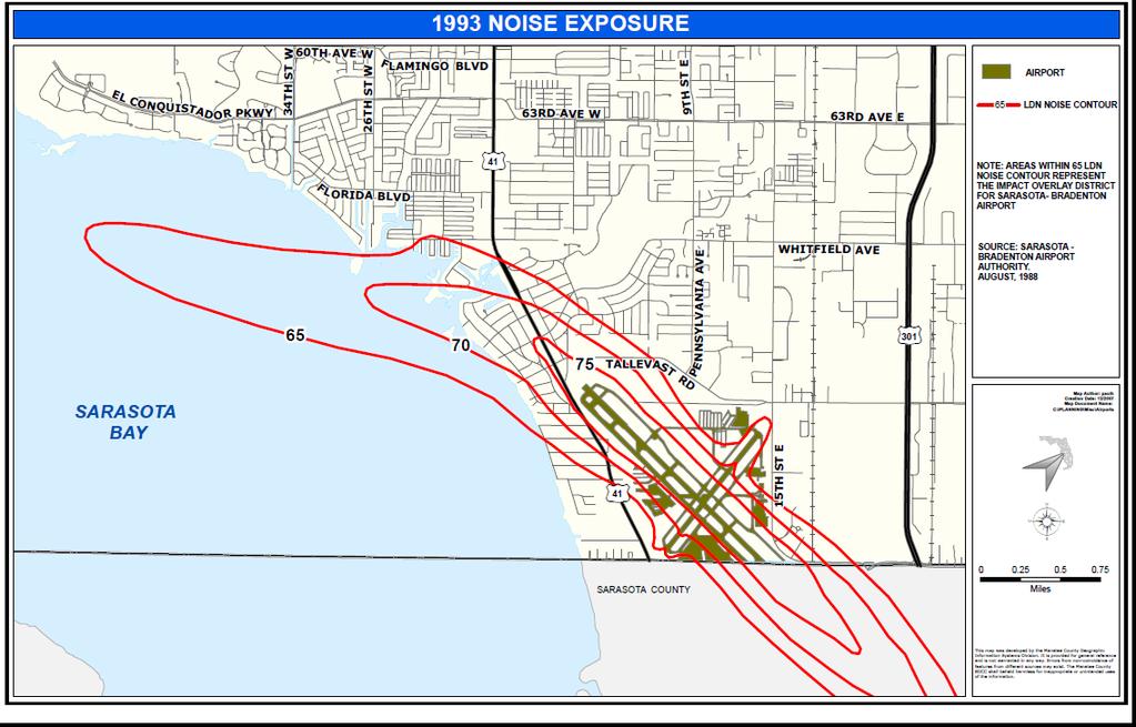
48
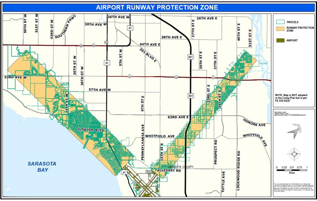
49
50 Attachment 10 Consistency with State Comprehensive Plan, Florida Administrative Code, and Florida Statutes PA-16-01/Ordinance The proposed amendment is consistent with Florida Statutes 163 Part II Process for adoption of comprehensive plan or plan amendment states in compliance means consistent with the requirements of ss , , , , and Required and optional elements of comprehensive plan; studies and surveys This plan amendment request maintains the structure of the Comprehensive Plan Coastal Management This plan amendment request maintains the structure of the Comprehensive Plan Concurrency This plan amendment request maintains the structure of the Comprehensive Plan Evaluation and appraisal of comprehensive plan The county has determined there is no need to amend the Comprehensive Plan through the Evaluation and Appraisal process (December 2013) Sector plans There are no sector plans established at this time Rural Land Stewardship areas There are no Rural Land Stewardship areas established at this time. The proposed amendment is consistent with the following goal(s) and policy(ies) of the State Comprehensive Plan: (15) (a)
51 Attachment 11 Survey Results
52
53
54
55
56
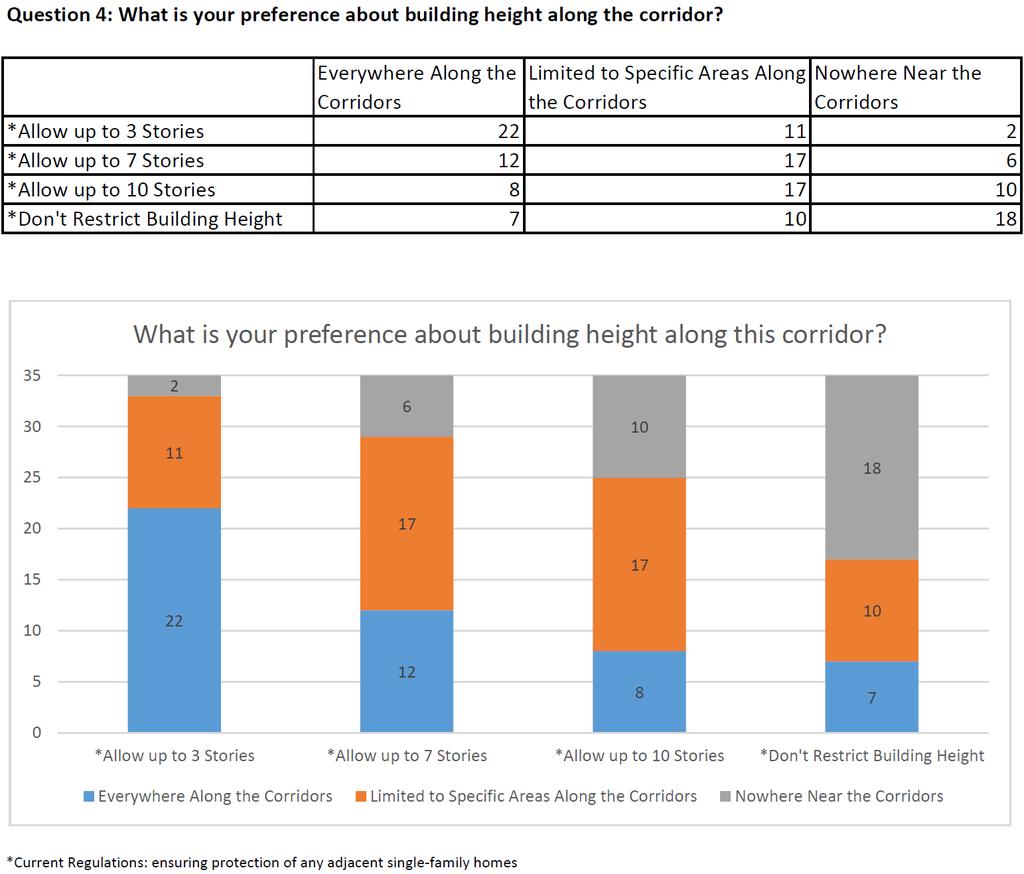
57
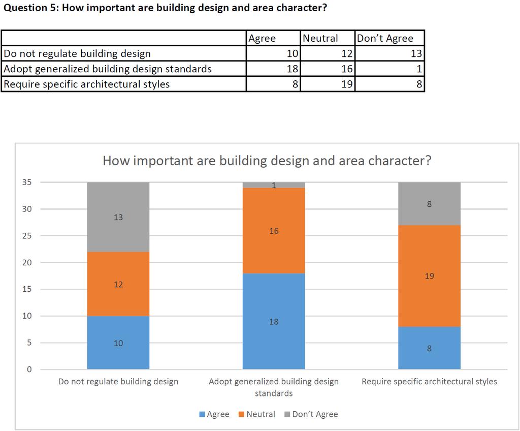
58
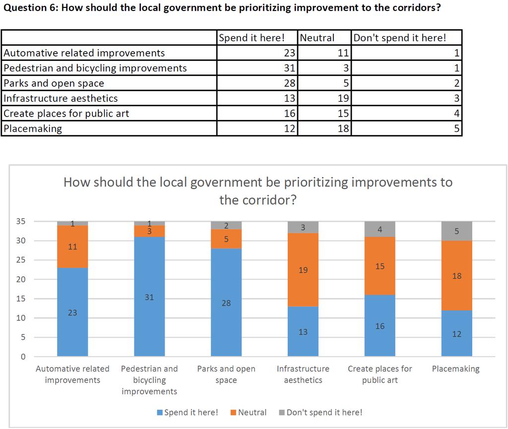
59
Working with Transportation Concurrency Exception Areas
 Working with Transportation Concurrency Exception Areas September 2006 Presented by the Florida Department of Transportation Working with Transportation Concurrency Exception Areas Volume 1, September
Hillsborough County Future Land Use 160
 RURAL-AGRICULTURE LAND USE CLASSIFICATION Agricultural/Mining -1/20 (AM-1/20) RESIDENTIAL GROSS DENSITY TYPICAL USES MAXIMUM FLOOR AREA RATIO OR Up to 1 dwelling unit per 20 gross acres. Alternative methods
LAND USE POLICIES BY COMMUNITY DESIGNATION
 137 2040 138 Land Use Policies by Community Designation As discussed earlier in Thrive MSP 2040, the Council assigns a community designation to each city and township. This designation indicates the overall
IX. STRATEGIC PLAN ELEMENT
 IX. STRATEGIC PLAN ELEMENT The Strategic Plan Element provides the action and implementation plan for the New Brunswick Master Plan. New Brunswick is a fully developed, older urban area in central New
Technical and Physical Feasibility Fact Sheet Alternative 28: Infill/Density
 Technical and Physical Feasibility Fact Sheet Alternative 28: Infill/Density Acknowledgements: This fact sheet was written by Phyllis Taylor of Sites Southwest as part of the Evaluation of Alternative
THE REGION S PLAN POLICY FRAMEWORK. August 2015
 THE REGION S PLAN POLICY FRAMEWORK August 2015 2 What is The Policy Framework? Cover photo credit: Sinan Sinharoy for Atlanta BeltLine, Inc. Atlanta is one of the world s most dynamic metropolitan areas,
OVERVIEW ORDINANCE: ORD # APPLICATION: 2014C-002
 PROPOSED SMALL-SCALE FUTURE LAND USE MAP (FLUM) AMENDMENT OVERVIEW ORDINANCE: ORD # 2014-191 APPLICATION: 2014C-002 APPLICANT: PAUL M. HARDEN PROPERTY LOCATION: 8101 Southside Boulevard Acreage: 1.76 Acres
URBAN CENTER COMMUNITY ROLE COUNCIL ROLE ALL COMMUNITIES URBAN CENTER
 Orderly and Efficient Land Use Align land use, development patterns, and infrastructure to make the best use of public and private investment. Plan for forecasted population and household growth at average
1.1.1.b. Agencies share best practices as they integrate COMPASS facilitates
 Transportation Goals 1.1 Enhance the system to improve accessibility and connectivity to jobs, schools, and services; allow the efficient movement of people and goods; and ensure the reliability of travel
Vero Beach Vision Plan
 Vero Beach Vision Plan City of Vero Beach, Florida Prepared in cooperation with: The Vero Beach Vision Team and The Citizens of Vero Beach Prepared by: Gould Evans Associates 4041 Mill Street Kansas City,
CRTPA Regional Mobility Plan Attachment 1 Agenda Item 4E Page 1 of 11
 CRTPA Regional Mobility Plan Attachment 1 Page 1 of 11 INTRODUCTION Everyone wants to have the ability to move around the city, county, region, country and world in the way that they see fit, when they
Currituck County Moyock Mega-Site Market Feasibility Study March 28, 2016
 Currituck County Moyock Mega-Site Market Feasibility Study March 28, 2016 Presentation Outline Project Background Demographic and Economic Data Review Competitive Market Analysis Feasibility Assessment
FERRY COUNTY COUNTY-WIDE PLANNING POLICIES
 FERRY COUNTY COUNTY-WIDE PLANNING POLICIES This memorandum of understanding lays out the framework upon which the comprehensive planning process for Ferry County and the City of Republic will be built.
SOUTHEAST FLORIDA REGIONAL COMPACT CLIMATE CHANGE. Sustainable Communities & Transportation Planning
 SOUTHEAST FLORIDA REGIONAL COMPACT CLIMATE CHANGE Draft Regional Climate Action Plan Sustainable Communities & Transportation Planning SP-1 Develop criteria in collaboration with municipal and county planning
TREASURE COAST REGIONAL PLANNING COUNCIL M E M O R A N D U M. To: Council Members AGENDA ITEM 3E
 TREASURE COAST REGIONAL PLANNING COUNCIL M E M O R A N D U M To: Council Members AGENDA ITEM 3E From: Date: Subject: Staff May 19, 2017 Council Meeting Local Government Comprehensive Plan Review Draft
SANTA CRUZ LOCAL AGENCY FORMATION COMMISSION SPHERES OF INFLUENCE POLICIES AND GUIDELINES
 SANTA CRUZ LOCAL AGENCY FORMATION COMMISSION SPHERES OF INFLUENCE POLICIES AND GUIDELINES I. Legislative Authority Amended by Resolution No. 2011-1; February 2, 2011 The Knox-Nisbet Act of 1963 (former
II. Land Use A. INTRODUCTION B. BACKGROUND
 II. Land Use A. INTRODUCTION The Land Use Element establishes a comprehensive set of explicit goals, policies and implementation actions which will guide the future use and development of land within the
Florida Department of Transportation Daniels Parkway Fort Myers, FL 33913
 RICK SCOTT GOVERNOR Florida Department of Transportation 10041 Daniels Parkway Fort Myers, FL 33913 ANANTH PRASAD, P.E. SECRETARY Mr. Ray Eubanks Plan Processing Administrator Department of Economic Opportunity
LAND USE PBF LDR ZONING PUD PUD. Proposed Maximum Density (DU/Acre) Existing Maximum Intensity (FAR) .30 FAR/ 173 dwelling units.
 Existing Maximum Intensity (FAR) .30 FAR/ 173 dwelling units.") PROPOSED LARGE SCALE FUTURE LAND USE MAP (FLUM) AMENDMENT OVERVIEW ORDINANCE: 2013-658 APPLICATION: 2013G-001-3-5 APPLICANT: PAUL HARDEN PROPERTY LOCATION: On the south side of Sunbeam Road, at the terminus
PROPOSED LARGE SCALE FUTURE LAND USE MAP (FLUM) AMENDMENT OVERVIEW ORDINANCE: 2013-658 APPLICATION: 2013G-001-3-5 APPLICANT: PAUL HARDEN PROPERTY LOCATION: On the south side of Sunbeam Road, at the terminus
III. King County Guiding Principles
 III. King County Guiding Principles 2016 Comprehensive Plan December 5, 2016 The Comprehensive Plan is based on the principles of creating sustainable neighborhoods, preserving open space, farmland, and
SP Old Florida Investment Resources, LLC SMR Aggregates SR 64 Borrow Pit (DTS # )
") H.O. 03/24/14 SP-14-01 Old Florida Investment Resources, LLC SMR Aggregates SR 64 Borrow Pit (DTS #201400001) Request: Approval of a Special Permit for major earthmoving in the A (General Agriculture)
H.O. 03/24/14 SP-14-01 Old Florida Investment Resources, LLC SMR Aggregates SR 64 Borrow Pit (DTS #201400001) Request: Approval of a Special Permit for major earthmoving in the A (General Agriculture)
Departure from Parking & Loading Standards
 The Maryland-National Capital Park and Planning Commission Prince George's County Planning Department Development Review Division 301-952-3530 Note: Staff reports can be accessed at www.mncppc.org/pgco/planning/plan.htm.
Project Plan for TAX INCREMENTAL FINANCE DISTRICT #41 (UNIVERSITY-WHITNEY) City of Madison
 City of Madison") Project Plan for TAX INCREMENTAL FINANCE DISTRICT #41 (UNIVERSITY-WHITNEY) City of Madison Prepared by: Department of Planning and Community and Economic Development Economic Development Division Office
Project Plan for TAX INCREMENTAL FINANCE DISTRICT #41 (UNIVERSITY-WHITNEY) City of Madison Prepared by: Department of Planning and Community and Economic Development Economic Development Division Office
 EXHIBIT 3 CORRESPONDENCE 1 8/15/16 BCT Broward Next Policy Concept EXHIBIT A Legend Qualified Transit Areas Areas highlighted in orange are within 0.5 miles of a rail station or 0.25 miles of a bus
Community Choices: Clermont County, OH
 Community Choices: Clermont County, OH Today s s Topics Why OKI has to consider land use in transportation planning OKI s Strategic Regional Policy Plan Regional and County Trends Community Choices: Altering
City of Sweetwater. Proposed Comprehensive Plan Amendments; EAR-Based Amendments & Capital Improvements Element Annual Update.
 Proposed Comprehensive Plan Amendments; EAR-Based Amendments & Capital Improvements Element Annual Update December 28, 2010 Florida International University Metropolitan Center Background Comprehensive
Adopted January 15, 1996 Hood River County Ordinance #201
 GOAL 3 AGRICULTURAL LANDS Adopted January 15, 1996 Hood River County Ordinance #201 A. GOAL: To preserve and maintain agricultural lands. B. POLICIES: 1. Agricultural land shall be preserved and maintained
Zoning Text Amendment
 Staff Report PLANNING DIVISION COMMUNITY & ECONOMIC DEVELOPMENT To: From: Salt Lake City Planning Commission Amy Thompson, 801-535-7281 or amy.thompson@slcgov.com Date: September 23, 2015 Re: PLNPCM2015-00578
City of Tacoma Planning and Development Services
 Agenda Item D-1 City of Tacoma Planning and Development Services To: Planning Commission From: Elliott Barnett, Planning Services Division Subject: Application #2014-01 Point Ruston Mixed-Use Center Meeting
SR 29 Project Development & Environment Study. Presentation to SR 29 Stakeholders Advisory Committee. January 23, 2014
 SR 29 Project Development & Environment Study Presentation to SR 29 Stakeholders Advisory Committee January 23, 2014 Purpose and Need Enhancing Economic Competitiveness Improving Emergency Evacuation Capabilities
Wheaton PRELIMINARY RECOMMENDATIONS
 Wheaton PRELIMINARY RECOMMENDATIONS Wheaton Finding the right balance of land uses within the diversity unique to Wheaton Wheaton s Role in the County Wheaton + Silver Spring = full set Services employment,
LUNDY S LANE COMMUNITY IMPROVEMENT PLAN STUDY
 PUBLIC INFORMATION MEETING # October, 0 LUNDY S LANE COMMUNITY IMPROVEMENT PLAN STUDY AGENDA :00 to :0pm: Open House :0 to :pm: Presentation : to :00pm: Individual paced workshop with the Study Team PUBLIC
CHAPTER 14. Key Public Investments
 CHAPTER 14 Key Public Investments Photo by MVI via Flickr Chapter 14. Key Public Investments Goal: Use public improvements to catalyze investment, increase revenues, minimize public expenditures, increase
City of Palo Alto (ID # 7047) City Council Staff Report
 City Council Staff Report") City of Palo Alto (ID # 7047) City Council Staff Report Report Type: Consent Calendar Meeting Date: 6/13/2016 Summary Title: East Palo Alto Comment Letter Title: Approval and Authorization for the City
City of Palo Alto (ID # 7047) City Council Staff Report Report Type: Consent Calendar Meeting Date: 6/13/2016 Summary Title: East Palo Alto Comment Letter Title: Approval and Authorization for the City
APPENDIX B. Public Works and Development Engineering Services Division Guidelines for Traffic Impact Studies
 APPENDIX B Public Works and Development Engineering Services Division Guidelines for Traffic Impact Studies Revised December 7, 2010 via Resolution # 100991 Reformatted March 18, 2011 TABLE OF CONTENTS
Tax Increment Finance: An Emerging Community Revitalization Tool
 Tax Increment Finance: An Emerging Community Revitalization Tool May 3, 2007 St. Louis, MO About CDFA National non-profit dedicated to the advancement of the development finance industry Founded in 1982
A THRIVING MIDDLE GEORGIA
 Plan for A THRIVING MIDDLE GEORGIA Regional Opportunities and Action Items Part I January 8, 2015 Update since December 16 Meetings in each of the 11 counties. Topics include: future development patterns
Purpose of the Countywide Transportation Plan SAN FRANCISCO COUNTY TRANSPORTATION AUTHORITY
 > 12 Purpose of the Countywide Transportation Plan SAN FRANCISCO COUNTY TRANSPORTATION AUTHORITY 13 SAN FRANCISCO S MULTIMODAL transportation network is crucial to San Francisco s status as a major regional
Notwithstanding article VII of this chapter, the following conditional uses may be permitted in the planned mixed use development (PMUD) zone:
 zone:") DIVISION 14. - PLANNED MIXED USE DEVELOPMENT (PMUD) Sec. 78-1021. - Purpose. The town is a community with a rich tradition of mixed use neighborhoods and a paucity of land area dedicated for large commercial,
DIVISION 14. - PLANNED MIXED USE DEVELOPMENT (PMUD) Sec. 78-1021. - Purpose. The town is a community with a rich tradition of mixed use neighborhoods and a paucity of land area dedicated for large commercial,
GOAL 13 ENERGY CONSERVATION
 GOAL 13 ENERGY CONSERVATION A. Goal: To conserve energy. B. Policies: Energy Conservation: c. Strategies: a. An energy policy cannot be completed in a single statement but should be a framework within
Your Bright Future: Municipal Development Plan
 Your Bright Future: Municipal Development Plan 2010-2020 Executive Summary OVERVIEW Municipalities face many challenges and opportunities. Central to a municipality s ability to provide a high standard
Introduction Page I-1 INTRODUCTION
 Introduction Page I-1 INTRODUCTION The Arcata General Plan: 2020 will help shape how the city of Arcata will look, function, provide services, and manage resources for the next 20 years. The plan is the
Subarea Mobility Enhancements. 5.1 Transit and Pedestrian Improvements
 Section Five Section 5: Subarea Mobility Enhancements 5.1 Transit and Pedestrian Improvements From the outset of the master planning process, one of the primary goals was to integrate transit and pedestrian-oriented
Transit Oriented Development Study
 Federal Way Link Extension Transit Oriented Development Study Table of Contents Executive Summary ES 1 Chapter 1: Introduction.. 1-1 Chapter 2: Methodology. 2-1 Chapter 3: Project Overview 3-1 Chapter
Infrastructure Financing Programs (DIF)
") Infrastructure Financing Programs (DIF) Massachusetts Municipal Association January 24, 2015 Infrastructure Needs in Massachusetts* Approximately 10% of bridges are classified as Structurally Deficient
Infrastructure Financing Programs (DIF) Massachusetts Municipal Association January 24, 2015 Infrastructure Needs in Massachusetts* Approximately 10% of bridges are classified as Structurally Deficient
SMART GROWTH IMPLEMENTATION COMMITTEE FINAL REPORT SUGGESTED COUNTY ACTIONS
 SMART GROWTH IMPLEMENTATION COMMITTEE FINAL REPORT SUGGESTED COUNTY ACTIONS SMART GROWTH PRINCIPLES (From Staff s Perspective) Foster Distinctive, Attractive Communities with a Strong Sense of Place Direct
INTERGOVERNMENTAL COORDINATION ELEMENT GOALS, OBJECTIVES, AND POLICIES
 INTERGOVERNMENTAL COORDINATION ELEMENT GOALS, OBJECTIVES, AND POLICIES Goal 8 To provide accessible, effective and frequent intergovernmental opportunities to achieve consistency among all government agencies
Calvert County Comprehensive Plan. October 2017 Draft
 Calvert County Comprehensive Plan October 2017 Draft DRAFT 10/16/17 Calvert County Comprehensive Plan CHAPTER 1. EXECUTIVE SUMMARY... 1-1 Calvert County s Twin Goals... 1-1 Visions... 1-1 Managing Residential
State of Florida Department of Community Affairs Areas of Critical State Concern Implementation Status Report Apalachicola Bay Area
 State of Florida Department of Community Affairs Areas of Critical State Concern Implementation Status Report Apalachicola Bay Area Thaddeus L. Cohen, AIA Secretary November 2006 CONTENTS Part 1 - Summary
2.1 Summary of Existing and Future Population Estimates
 SECTION 2 Demographics This technical memorandum identifies the uncertainties and describes potential future demographics that might affect wastewater facilities in the City of McCall, Idaho (the City).
TRANSPORTATION IMPACT STUDIES
 January 28, 2009 POLICIES AND PROCEDURES FOR TRANSPORTATION IMPACT STUDIES Related to Highway Occupancy Permits Pennsylvania Department of Transportation Bureau of Highway Safety and Traffic Engineering
YAKIMA COUNTY-WIDE PLANNING POLICY
 YAKIMA COUNTY-WIDE PLANNING POLICY A Policy Framework to Guide the Development of Comprehensive Plans Under the Washington State Growth Management Act Originally adopted June 1993 Revised and adopted October
Potable Water Supply, Wastewater & Reuse Element
 Potable Water Supply, Wastewater & Reuse Element GOAL ONE: HIGH QUALITY AND AFFORDABLE POTABLE WATER WILL BE AVAILABLE TO MEET THE EXISTING AND PROJECTED DEMANDS OF PINELLAS COUNTY UTILITY CUSTOMERS. 1.1.
Public Hearing January 13, Request Conditional Use Permit (Auto Repair Garage) Staff Planner Carolyn A.K. Smith
 Staff Planner Carolyn A.K. Smith") Applicant Property Owner Holland Century Associates, LLP Public Hearing January 13, 2016 Request Conditional Use Permit (Auto Repair Garage) Staff Planner Carolyn A.K. Smith Location 3949 Holland Road
Applicant Property Owner Holland Century Associates, LLP Public Hearing January 13, 2016 Request Conditional Use Permit (Auto Repair Garage) Staff Planner Carolyn A.K. Smith Location 3949 Holland Road
Sustainability. Sustainability Principles. 1. Framework. Spokane Transit s definition of Sustainability is:
 Sustainability Spokane Transit s definition of Sustainability is: Sustainability at Spokane Transit is about providing services in ways that optimize our ability to meet the needs of present and future
Memorandum. FROM: Jim Ortbal Rosalynn Hughey Barry Ng TO: HONORABLE MAYOR, CITY COUNCIL. DATE: June 16, 2017
 CITY OF SANjOSE CAPITAL OF SILICON VALLEY TO: HONORABLE MAYOR, CITY COUNCIL SUBJECT: TRANSPORTATION POLICY UPDATE REQUIRED BY STATE LAW - LOS TO VMT Memorandum FROM: Jim Ortbal Rosalynn Hughey Barry Ng
Introduction: Jason Giffen, Assistant Vice President, Planning and Green Port
 Introduction: Jason Giffen, Assistant Vice President, Planning and Green Port Today I want to talk about how the Port of San Diego is preparing for it s future through planning, implementation, and exploration.
Zoning codes and land use regulations need
 F. Zoning and Other Development Regulations Zoning codes and land use regulations need reorganizing and updating from time to time. Incremental amendments can introduce inconsistencies, ambiguity, and
Ballard-Interbay MIC Summary Statistics
 BallardInterbay MIC Founded in 1869, the City of Seattle is the leading commercial, cultural and advanced technology center of the U.S. Pacific Northwest, and a major port city for transpacific and European
Chapter One LAND USE ELEMENT INTRODUCTION
 Chapter One LAND USE ELEMENT INTRODUCTION The Land Use Element designates the type, intensity, and general distribution of uses of land for housing, business, industry, open space, agriculture, natural
CITY OF JACKSONVILLE 2030 MOBILITY PLAN STUDY UPDATE GOALS, OBJECTIVES, AND PERFORMANCE MEASURES PREPARED FOR: CITY OF JACKSONVILLE
 CITY OF JACKSONVILLE 2030 MOBILITY PLAN STUDY UPDATE GOALS, OBJECTIVES, AND PERFORMANCE MEASURES 3.20.2017 PREPARED FOR: CITY OF JACKSONVILLE 55 Railroad Row White River Junction, VT 05001 802.295.4999
An Overview of Tax Increment Financing and Economic Development
 An Overview of Tax Increment Financing and Economic Development A Presentation to the City of Saco, Maine November 14, 2016 www.camoinassociates.com What is Tax Increment Financing (TIF)? A financing method
University North Park TIF Project. City of Norman, Oklahoma TIF District No. 2
 University North Park TIF Project City of Norman, Oklahoma TIF District No. 2 WHAT IS A TIF? TIF is short for tax increment finance districts. These are development tools authorized by state law for cities
Corridor Residential Traditional District Regulations City of St. Petersburg City Code Chapter 16, Land Development Regulations
 Section 16.20.060 - Corridor Residential Traditional Districts ( CRT ) Typical Buildings in the CRT District Sections: 16.20.060.1 Composition of Traditional Residential Corridors 16.20.060.2 Purpose and
Neighborhood Traditional Single-Family District Regulations City of St. Petersburg City Code Chapter 16, Land Development Regulations
 Section 16.20.010 - Neighborhood Traditional Single-Family Districts ( NT ) Typical Houses in a Neighborhood Traditional District Typical Block in a Neighborhood Traditional District Common Features of
FAQ Sheet. Proposed Southside St. Petersburg Community Redevelopment Area
 The City of St. Petersburg is proposing to designate Southside St. Petersburg as a community redevelopment area (CRA), an effort that will last throughout the remainder of 2013 and carry into 2014. The
City of La Palma Agenda Item No. 2
 City of La Palma Agenda Item No. 2 MEETING DATE: March 9, 2015 TO: FROM: SUBMITTED BY: AGENDA TITLE: DEVELOPMENT COMMITTEE DOUGLAS D. DUMHART COMMUNITY DEVELOPMENT DIRECTOR SCOTT HUTTER, ASSOCIATE PLANNER
DOWNTOWN FREDERICK HOTEL AND CONFERENCE CENTER PROJECT Frequently Asked Questions (FAQ s) Version
 Version") DOWNTOWN FREDERICK HOTEL AND CONFERENCE CENTER PROJECT Version 3.0 12-3-15 The following are provided to assist with factual responses to questions, concerns, or interest in the project. This is a fluid
DOWNTOWN FREDERICK HOTEL AND CONFERENCE CENTER PROJECT Version 3.0 12-3-15 The following are provided to assist with factual responses to questions, concerns, or interest in the project. This is a fluid
Osceola County Long Range Transit Plan. Prepared for. Prepared by
 TABLE OF CONTENTS title PAGE Prepared for Prepared by TABLE OF CONTENTS 4.2.5. US 441/Orange Blossom Trail/US 17-92... 23 4.2.6. Lake Toho Parkway (Proposed)... 23 4.2.7. Southport Connector/SR 417 Extension
Oregon Theodore R. Kulongoski, Governor
 Oregon Theodore R. Kulongoski, Governor NOTICE OF ADOPTED AMENDMENT Department of Land Conservation and Development 635 Capitol Street NE, Suite 150 Salem, Oregon 97301-2524 Phone: (503) 373-0050 First
The Policies section will also provide guidance and short range policies in order to accomplish the goals and objectives.
 4 Goals & Objectives INTRODUCTION The 2015-2040 MTP preserves and promotes the quality of life and economic prosperity of the MAB by providing a transportation system consistent with the regional goals.
CHAPTER 13 R-5 MANUFACTURED MOBILE HOME PARK RESIDENTIAL DISTRICT
 15.1300 CHAPTER 13 R-5 MANUFACTURED MOBILE HOME PARK RESIDENTIAL DISTRICT 15.1301 SECTION 13.01 STATEMENT OF PURPOSE To provide for manufactured home park development, of long-term duration of stay, in
Provincial Policy Statement 2014 Training Aid
 This job aid has been developed for education and training purposes as a high-level summary of the policy changes in the PPS 2014. It should not be relied upon as a substitute for specialized legal or
COMMISSION ACTION FORM SUBJECT: PROPOSED BARILLA URBAN RENEWAL AREA AND TAX INCREMENT FINANCING DISTRICT
 ITEM # 7 DATE 06-21-17 COMMISSION ACTION FORM SUBJECT: PROPOSED BARILLA URBAN RENEWAL AREA AND TAX INCREMENT FINANCING DISTRICT BACKGROUND: At the City Council meeting on February 28, 2017, the City Manager
PARCEL P-12 DEVELOPMENT & URBAN DESIGN GUIDELINES
 PARCEL P-12 DEVELOPMENT & URBAN DESIGN GUIDELINES Development Guidelines Parcel P-12 is an approximately 30,000 square feet parcel located in the South Cove Urban Renewal Area, owned by the Boston Redevelopment
Working Group Agenda Meeting 1
 KITTITAS COUNTY COMMUNITY DEVELOPMENT SERVICES Building Partnerships Building Communities 411 N. Ruby St., Suite 2, Ellensburg, WA 98926 COMPPLAN@CO.KITTITAS.WA.US Office (509) 962-7506 Fax (509) 962-7682
Department: Physical Classification: Union: Wage Class: Salary Range: Organizational Summary: Job Description-Planning & Zoning Admin.
 Title: Department: Physical Classification: Union: Wage Class: Salary Range: Planning and Zoning Administrator Planning and Zoning Light / Sedentary N/A Hourly, Full-time (40 hours a week) Part-time applicants
TRANSPORTATION IMPACT ANALYSIS GUIDELINES
 TRANSPORTATION IMPACT ANALYSIS GUIDELINES SANTA CLARA COUNTY TRANSPORTATION AUTHORITY CONGESTION MANAGEMENT PROGRAM ADOPTED MARCH 2009 TABLE OF CONTENTS PART I - STATUTE AND AUTHORITY...1 CHAPTER 1. CMP
Rapid Transit in Winnipeg. Winnipeg TOD Summit November 17, 2014
 Rapid Transit in Winnipeg Winnipeg TOD Summit November 17, 2014 Presentation Overview Rapid Transit (RT) in Winnipeg What is RT? What are our RT plans? Near term Longer term Comments re: TOD OurWinnipeg
LEGISLATIVE AGENDA. North Myrtle Beach Chamber of Commerce Local Legislative Agenda PUBLIC POLICY COUNCIL GOAL:
 North Myrtle Beach Chamber of Commerce Local Legislative Agenda 2014-2015 LEGISLATIVE AGENDA PUBLIC POLICY COUNCIL GOAL: Our commitment is to be recognized as the business voice in the legislative process,
Chapter 4. Evaluation of Plan Alternatives
 Chapter 4. Evaluation of Plan Alternatives 4.1. Introduction 4.1.1. State Requirements The primary intent of the alternatives analysis in an EIR, as stated in 15126.6(a) of the State CEQA Guidelines, is
Department of Planning and Land Services Director
 Pierce County Department of Planning and Land Services DENNIS HANBERG Director 2401 South 35th Street Tacoma, Washington 98409-7460 C-4 COMMUNITY PLAN AMENDMENT: SOUTH HILL EMPLOYMENT SERVICES ZONE (ES)
Corporate Report. Report from Office of the Chief Administrative Officer, Administration
 Corporate Report Report from Office of the Chief Administrative Officer, Administration Date of Report: April 12, 2013 Date of Meeting: April 22, 2013 Report Number: CAO-110-2013 File: 35.23.26 Subject:
Mall Area Redevelopment TIF District Proposal
 Mall Area Redevelopment TIF District Proposal (SDFPAB) Economic Development Committee April 7, 2014 Purpose Provide background for each redevelopment area Provide overview of proposal for new TIF district
TRANSPORTATION TRANSPORTATION 9-1
 TRANSPORTATION Community Vision 2028 Because we place such high value on our natural surroundings, we responsibly plan for, manage, and mitigate the impacts of growth on those surroundings. Kezziah Watkins
Project Plan and Financing Plan for Reinvestment Zone Number Two,
 Project Plan and Financing Plan for Reinvestment Zone Number Two, City of Richardson, Texas (Program for Tax Increment Financing) Revised November 2012 Stein Planning, LLC by for the City of Richardson
Provincial. Statement
 Provincial Statement This publication was produced by the Ministry of Municipal Affairs and Housing. For more copies of this document, in either English or French, please contact: Publications Ontario
MADISON COUNTY 2020 LAND USE AND RESOURCE MANAGEMENT PLAN
 TABLE OF CONTENTS MADISON COUNTY 2020 LAND USE AND RESOURCE MANAGEMENT PLAN PART I EXECUTIVE SUMMARY Executive Summary... 1 Plan Goals... 4 Plan Recommendations... 5 American Bottoms Corridor Plan... 5
B-2 COMMUNITY COMMERCIAL BUSINESS DISTRICT. Uses allowed in the B-2 Community Commercial Business District are subject to the following conditions:
 SECTION 46-53.1 B-2 COMMUNITY COMMERCIAL BUSINESS DISTRICT A. PURPOSE The B-2 Community Commercial Business District is oriented toward retail, service businesses and multi-family residential development.
2.9 PLANNING ISSUES SUSTAINABILITY AND ENERGY
 2.9 PLANNING ISSUES SUSTAINABILITY AND ENERGY Objectives: 1. To create an enduring future that promotes quality of life, financial prosperity and innovative ideas and technologies while respecting and
MnDOT GREATER MN STAND ALONE NOISE BARRIER PROGRAM
 MnDOT GREATER MN STAND ALONE NOISE BARRIER PROGRAM 7 November 2017 MINNESOTA S EXPERIENCE WITH HIGHWAY NOISE MITIGATION The Minnesota Department of Transportation (MnDOT) has been constructing noise walls
MDX Contract #: RFP MDX Work Program #: ETDM #: 11501
 SR 874/Don Shula Expressway Ramp Connector Project Development & Environment (PD&E) Study PUBLIC HEARING December 8, 2011 MDX Contract #: RFP-09-04 MDX Work Program #: 87410.011 ETDM #: 11501 1 This Public
1RUWKZHVW#:LFKLWD 0DMRU#,QYHVWPHQW#6WXG\
 1RUWKZHVW#:LFKLWD 0DMRU#,QYHVWPHQW#6WXG\ Executive Summary 3UHSDUHGýIRUã 3UHSDUHGýE\ã.DQVDVý'HSDUWPHQWýRI 7UDQVSRUWDWLRQ,QýDVVRFLDWLRQýZLWKã (DUWKý7HFKý,QFï EXECUTIVE SUMMARY Introduction This Northwest
PROVINCIAL POLICY STATEMENT RELATION TO THE PROVINCIAL PLAN
 COUNTY OF LAMBTON OFFICIAL PLAN UPDATE BACKGROUND REPORT NO. 1 PROVINCIAL POLICY STATEMENT RELATION TO THE PROVINCIAL PLAN Image Source: (Word Clip Art Stock Photos, 2011) Date: May, 2015 BACKGROUND PLANNING
Prepared for: Broome County Department of Planning and Economic Development Allee King Rosen & Fleming, Inc.
 LAND USE CONSIDERATIONS FOR THE BROOME COUNTY PLAN FOR SUSTAINABLE ECONOMIC DEVELOPMENT Recommendations by the Broome County Environmental Management Council Adopted April 16, 2002 Prepared for: Broome
POTABLE WATER ELEMENT
 Goal 4.0. Provide current and future residents of the County's utility service areas, and large users of the regional raw water system a cost-effective and equitable potable or raw water supply system
GRAND NIAGARA Proposed Secondary Plan
 GRAND NIAGARA Proposed Secondary Plan Public Open House #3 January 17. 2017 scope + process BUILT Grand Niagara Secondary Plan The Grand Niagara Secondary Plan will establish a framework for the future
6.0 Indirect Effects and Cumulative Impacts
 6.0 Effects and Impacts 6.1 Introduction This chapter of the Draft EIS addresses potential indirect and cumulative impacts of the Bottineau Transitway project. effects are those that are caused by the
SPACE COAST TRANSPORTATION PLANNING ORGANIZATION
 SPACE COAST TRANSPORTATION PLANNING ORGANIZATION DRAFT AUGUST 2015 This page intentionally left blank SPACE COAST TRANSPORTATION PLANNING ORGANIZATION DRAFT AUGUST 2015 prepared by: This page intentionally