Monitoring water quality of the Southeastern Mediterranean sea using remote sensing
|
|
|
- Reynold Wheeler
- 6 years ago
- Views:
Transcription

1 Monitoring water quality of the Southeastern Mediterranean sea using remote sensing Tamir Caras The Remote Sensing Laboratory Jacob Blaustein Institutes for Desert Research Ben-Gurion University of the Negev 1

2 Overview Water quality basics and overview Remote sensing of water quality Temporal and spatial dimension Problem solving: chlorophyll and TSS separation VENµS 2


3 Water quality basics and overview Water quality and detecting Pollution Physical Chemical Biological Thermal Sediments (TSS) Dissolved organic matter Algae Sea Surface Temperature (SST) 3 3

4 Sewage ponds - oxidation process 4
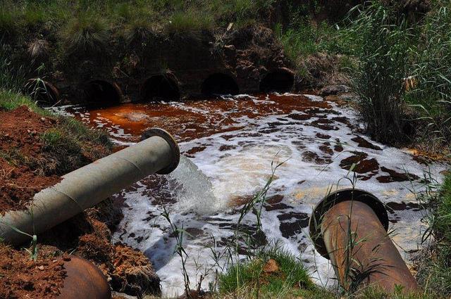
5 And anthropogenic pollution 5

6 Remote sensing of water quality Reflectance = Detected energy / Available energy 6
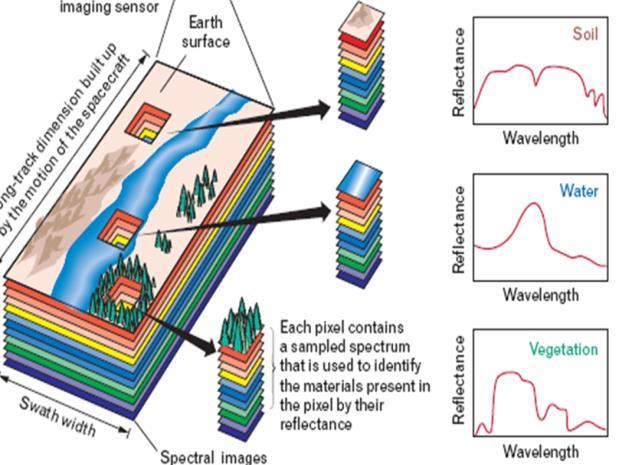
7 Spectral signature of ground features Signatures the foundation of detection Visible Reflected Infrared 7
![Chlorophyll and TSS separation Suspended Matter [mgl -1 ] Problem : Suspended matter present in water affects Chl-a* detection erroneously high Chl-a](/docs-images/77/75552920/images/8-1.jpg "detected * Chl-a represents algae that is an indicator of pollution Suspended Matter June 2001 Chlorophyll June 2001 Egypt Israel Egypt Israel Chlorophyll")
8 Chlorophyll and TSS separation Suspended Matter [mgl -1 ] Problem : Suspended matter present in water affects Chl-a* detection erroneously high Chl-a detected * Chl-a represents algae that is an indicator of pollution Suspended Matter June 2001 Chlorophyll June 2001 Egypt Israel Egypt Israel Chlorophyll [mgm -3 ] 8

9 Solution: Careful masking high levels of sedimentation Chlorophyll June 2001 After masking sediments: Chlorophyll June 2001 Israel Egypt Chlorophyll [mgm -3 ] Chlorophyll [mgm -3 ] 9
 2")

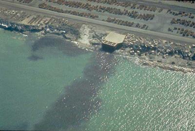
10 Coastal pollution near Tel Aviv Chlorophyll (mg/m 3 ) 2 February 2003 A sewage pipe breaks and raw sewage pores into the sea 10


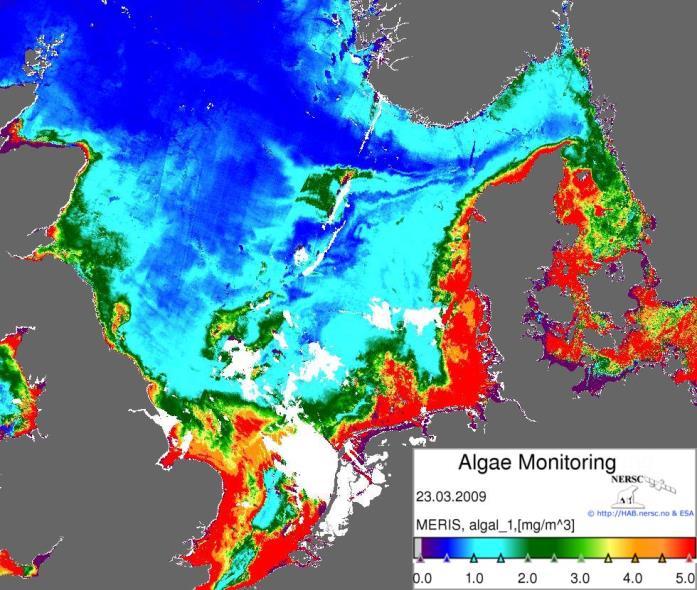
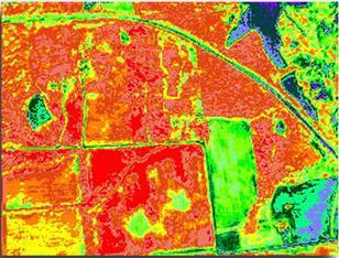
11 Monitoring an algal event: June
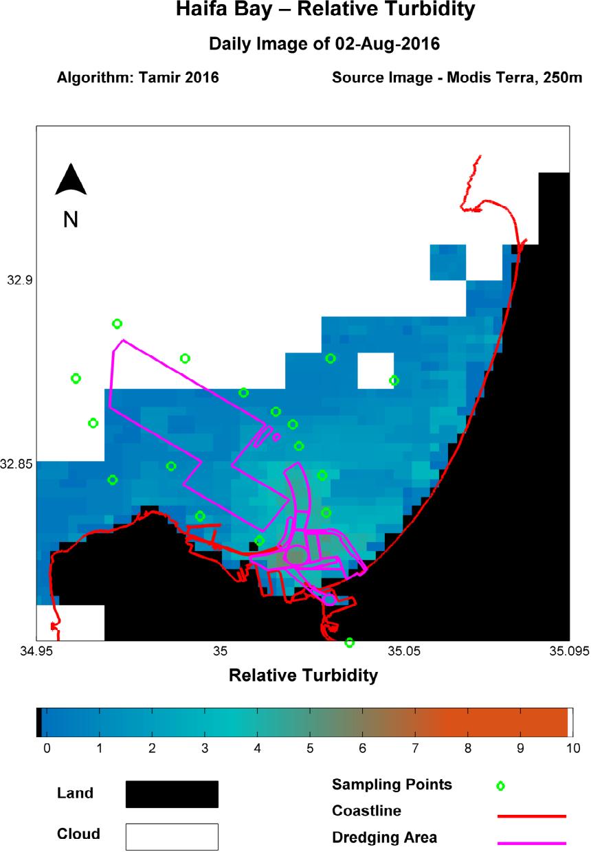
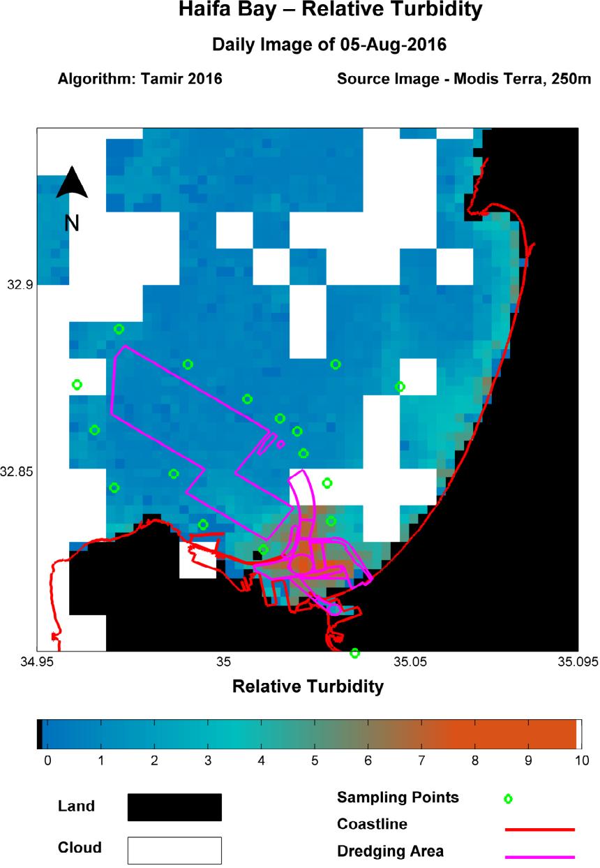
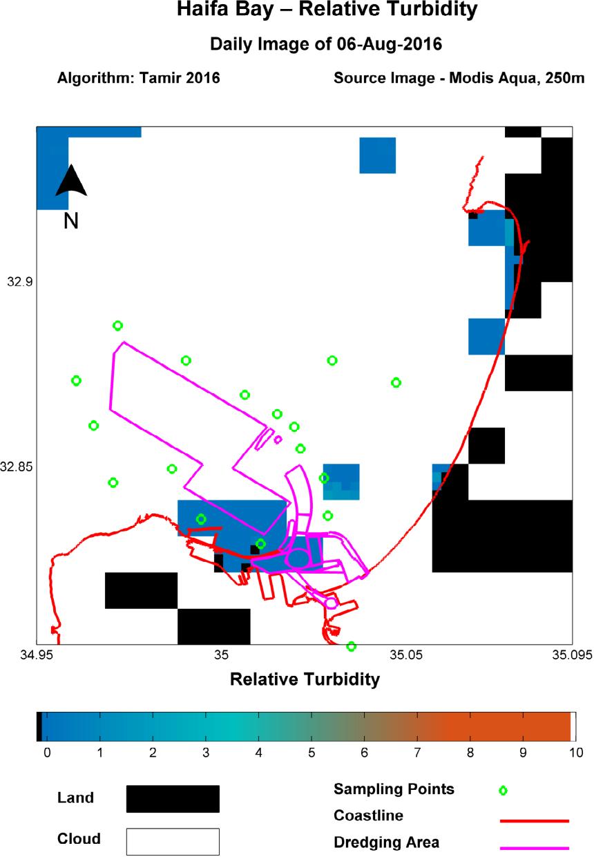
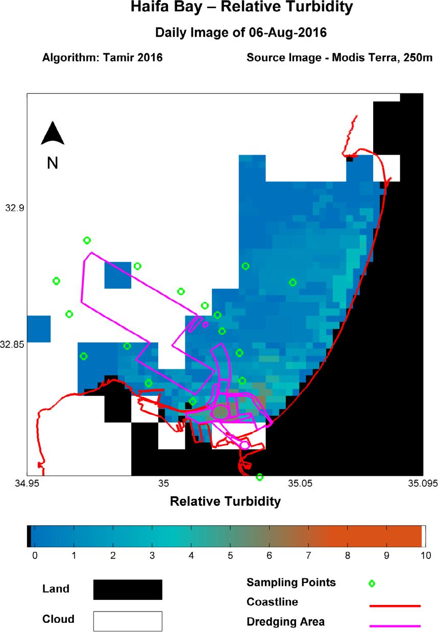
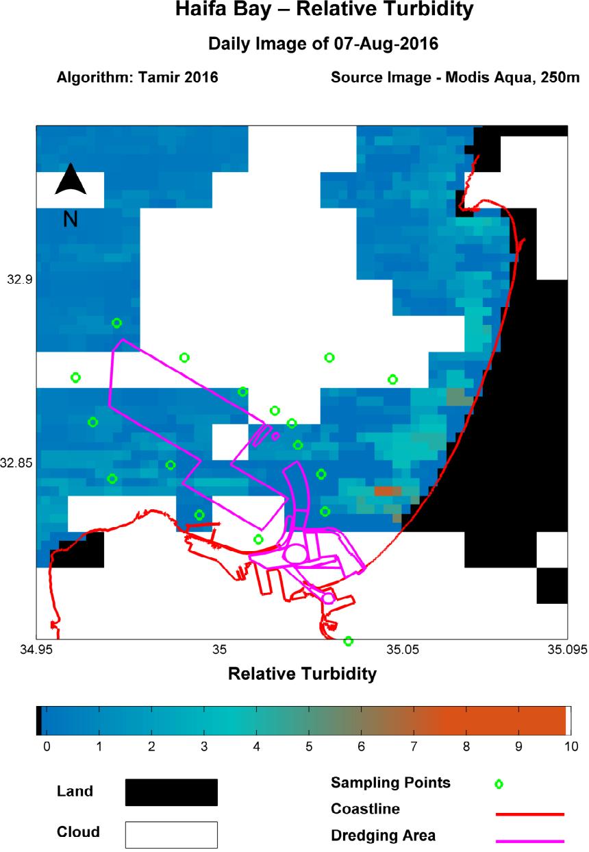
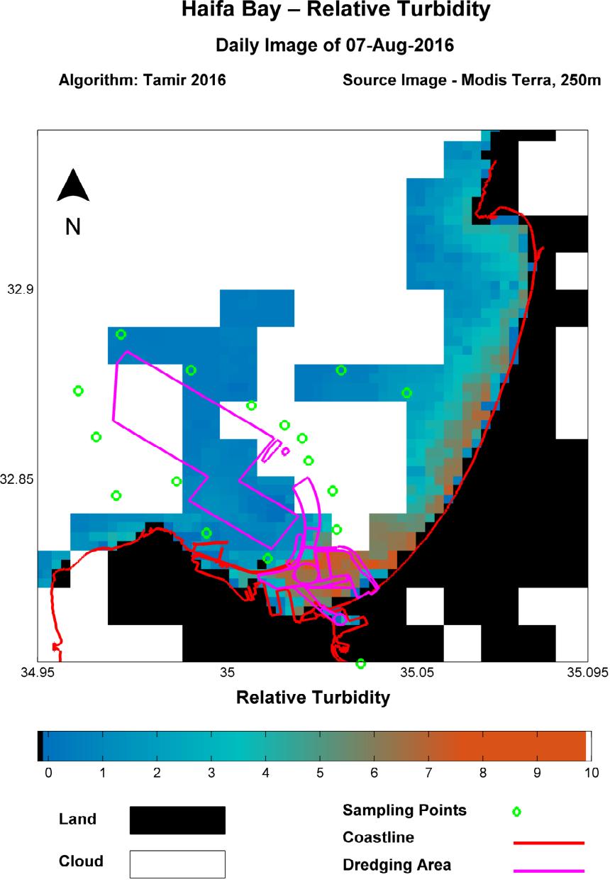


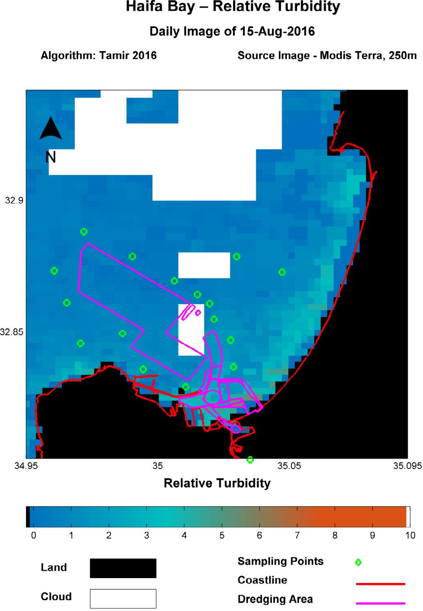
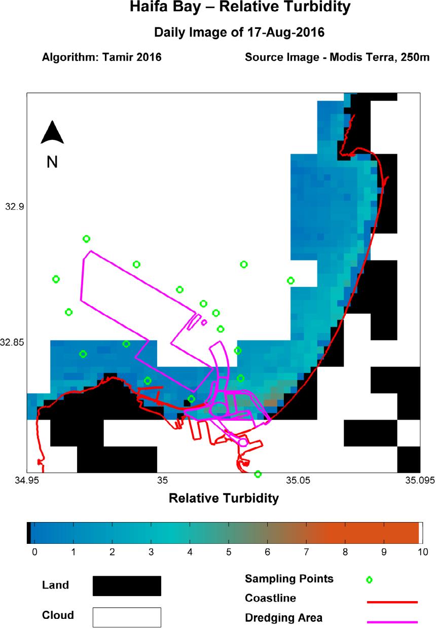
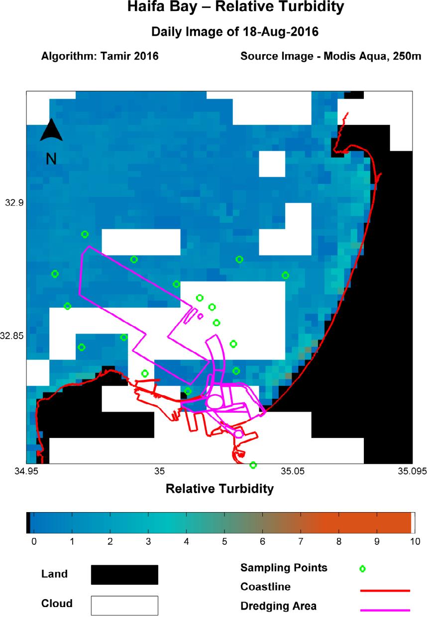

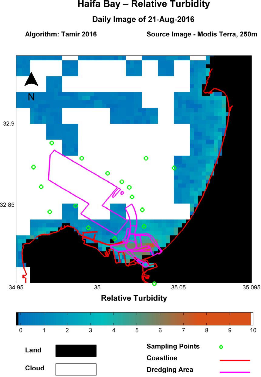


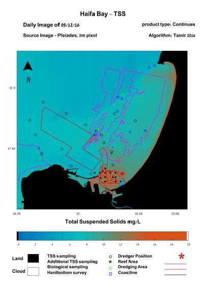
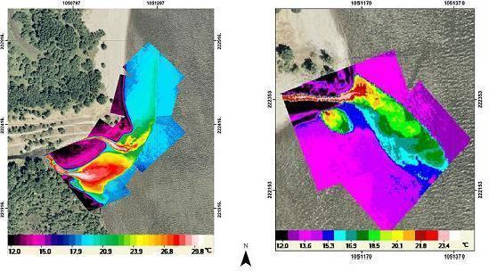
12 Monitoring sedimentation in Haifa port August
13 VENµS - Scientific Applications Land Vegetation Agriculture Digital Elevation Model Atmosphere Water Water quality Inland and coastal water Precision farming Water vapor Aerosol optical thickness Cloud and height 13
 Tilting capability: +/-30 across and along track Radiometric resolution: 10 bits Equator crossing time: 10:30 AM, descending mode Mission start/duration:")
14 VENµS Mission Characteristics Orbit: near polar, sun-synchronic (constant view angle) Altitude: 720 km Inclination: Revisit time: two days Swath: km Spatial resolution: 5.3 m Number of spectral bands: 12 (VIS-NIR) Tilting capability: +/-30 across and along track Radiometric resolution: 10 bits Equator crossing time: 10:30 AM, descending mode Mission start/duration: June, 2017, 4.25 years June
15 Spectra of Water Constituents Volume Reflectance Clear Water Null Null Point Point Chl, ug/l SM, mg/l CDOM, mgc/l B1 B3 B2 B4 Clear Water B5 B6 B7 B8 B Wavelength (nm) 15

16 Conclusion Venus may not be the best at any one category but it is the best all-rounder spaceborne sensor to date 16
17 17
18 18


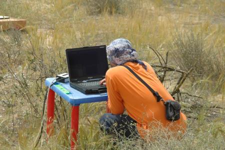
19 Remote Sensing of river chlorophyll ote Sensing dissolved carbon in lakes and coast 19
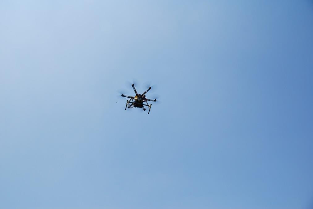
 Remote Sensing the Phytoplankton Seasonal")
20 Red Sea seasonal climatologies of MODIS Chl-a (mg/m3) and SST ( C). Raitsos DE, Pradhan Y, Brewin RJW, Stenchikov G, Hoteit I (2013) Remote Sensing the Phytoplankton Seasonal Succession of the Red Sea. PLOS ONE 8(6): e
 Digitise This! A Quick and Easy Remote Sensing Method to Monitor the Daily Extent of Dredge Plumes.")
21 Series of images showing how the digitised plume of a MODIS image relates to a clearer high resolution image and the range of TSS thresholds analysed in this study. Evans RD, Murray KL, Field SN, Moore JAY, Shedrawi G, et al. (2012) Digitise This! A Quick and Easy Remote Sensing Method to Monitor the Daily Extent of Dredge Plumes. PLOS ONE 7(12): e

22 Absorption and Scattering Attenuation in Pure Water Maximum Transparency at 470 nm Effective Wavelength = nm 22 22
23 23 23
24 25
25 R 510 > Rule 1 A RS ( xi, yi) 26
")
26 Rule 1 A R 765 > RS ( xi, yi) 27
 ( xi, yi) > 2.0 28")
27 Rule 2 R R RS RS ( xi, yi) ( xi, yi) >
28 Radiometer vs. Spectrometer Radiometer Point spectrometer Image spectrometer 29
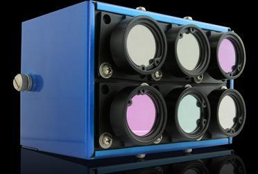
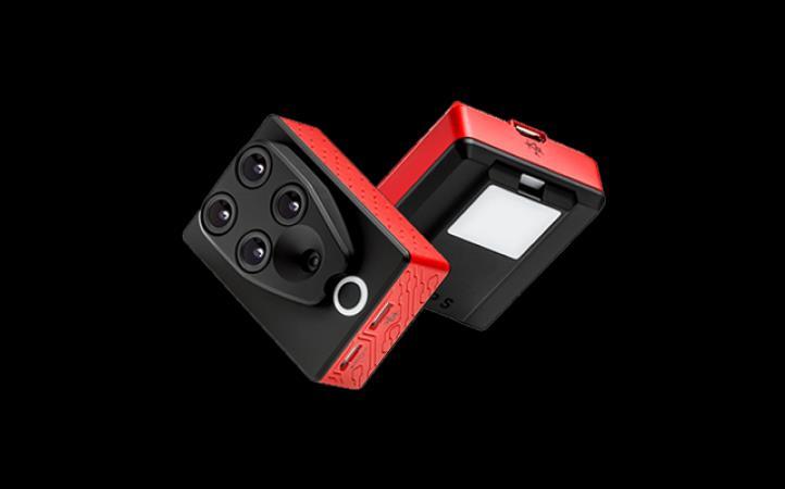
29 Multispectral Camera 6 band 30


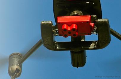
30 MS Camera on a Drone 31

31 Other Systems 32
32 33


33 Water Constituents Chlorophyll Sediments Dissolved organic carbon 34
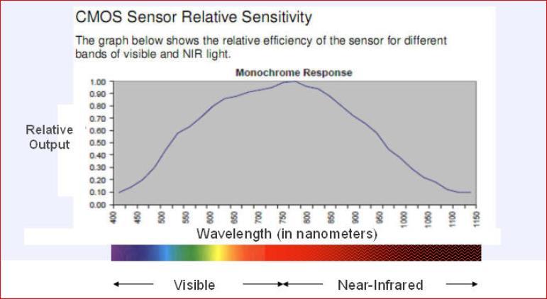
34 Scientific Applications 35 Band Center Land/Vegetation Water quality Atmosphere (nm) Desert lower plants Dissolved organic matter; Turbidity Atmospheric resistance Maximum chlorophyll-a vegetation indices absorption Chlorophyll, other pigments; attenuation Green peak; Vegetation Chlorophyll reference; indices Suspended sediments Chlorophyll absorption; Suspended sediments Detect clouds and cloud edges Atmospheric correction Cloud properties Vegetation indices Digital Elevation Model Suspended sediments Top cloud detection Red edge Chlorophyll absorption Cloud properties Red edge Red edge Red edge Maximum reflectance; Vegetation indices Water vapor reference Water vapor April 27, 2006
Measuring Ocean Color: The Basics
 Measuring Ocean Color: The Basics Radiation of energy from the Sun and the Earth s surface. Recall from previous lectures that the Sun (6000 K), radiates energy in three portions of the energy spectrum:
Mapping water constituents concentrations in estuaries using MERIS full resolution satellite data
 Mapping water constituents concentrations in estuaries using MERIS full resolution satellite data David Doxaran, Marcel Babin Laboratoire d Océanographie de Villefranche UMR 7093 CNRS - FRANCE In collaboration
Lake transparency: a window into decadal variations in dissolved organic carbon concentrations in Lakes of Acadia National Park, Maine
 Lake transparency: a window into decadal variations in dissolved organic carbon concentrations in Lakes of Acadia National Park, Maine Collin Roesler Department of Earth and Oceanographic Science, Bowdoin
Estimation of Water Quality Parameters for Lake Kemp Texas Derived From Remotely Sensed Data.
 Estimation of Water Quality Parameters for Lake Kemp Texas Derived From Remotely Sensed Data. Bassil El-Masri and A. Faiz Rahman Department of Natural Resources Management, Texas Tech University, Box 42125,
Land surface albedo and downwelling shortwave radiation from MSG: Retrieval, validation and impact assessment in NWP and LSM models
 Land surface albedo and downwelling shortwave radiation from MSG: Retrieval, validation and impact assessment in NWP and LSM models Jean-Louis ROUJEAN, Dominique CARRER, Xavier CEAMANOS, Olivier HAUTECOEUR,
Application of Gliders for Near-Real Time METOC Data Collection Capability for Battlespace Characterization
 DISTRIBUTION STATEMENT A: Approved for public release; distribution is unlimited. Application of Gliders for Near-Real Time METOC Data Collection Capability for Battlespace Characterization Charles Trees
Belair Litora. B E L A I R WO R KS H OP J U N E 1 3, G e m bl o u x, B e l g i um
 Belair Litora B E L A I R WO R KS H OP 2 0 1 4 - J U N E 1 3, 2 0 1 4 G e m bl o u x, B e l g i um E l s k n a e ps, D r i e s R ay m a e ke rs, S i v e e C h a w l a, N i t i n B h a t i a, P i e t e
Light and the Aquatic Ecosystem
 Light and the Aquatic Ecosystem Why is light important? Ultimate source of energy in all carbon containing materials entering the water. Sunlight drives the entire aquatic ecosystem. What Do Limnologists
Global Warming: What is the role of aerosol?
 Global Warming: What is the role of aerosol? Barbara Wyslouzil, Sept. 10 2007 Outline Aerosols 101 The greenhouse effect Global temperature records The global warming problem How do aerosols play a role
SPECTRAL REFLECTANCE SIGNATURES OF CASE II WATERS: POTENTIAL FOR TROPICAL ALGAL BLOOM MONITORING USING SATELLITE OCEAN COLOUR SENSORS
 Paper presented at the th JSPS/VCC Joint Seminar on Marine and Fisheries Sciences, Melaka, Malaysia, 9 Nov - Dec 999 SPECTRAL REFLECTANCE SIGNATURES OF CASE II WATERS: POTENTIAL FOR TROPICAL ALGAL BLOOM
Detecting Change in the Global Ocean Biosphere using SeaWiFS Satellite Ocean Color Observations
 Detecting Change in the Global Ocean Biosphere using SeaWiFS Satellite Ocean Color Observations Part 2: Confronting Bio-Optical Complexity David Siegel Earth Research Institute, UC Santa Barbara david.siegel@ucsb.edu
EUTROPHICATION. Student Lab Workbook
 EUTROPHICATION Student Lab Workbook THE SCIENTIFIC METHOD 1. Research Background literature research about a topic of interest 2. Identification of a problem Determine a problem (with regards to the topic)
AlgaeTorch. The handy measurement instrument for rapid deployment. Fast and simple algae monitoring
 www.bbe-moldaenke.de The handy instrument for rapid deployment Fast and simple algae monitoring Designed for all types of surface water: lakes, reservoirs, rivers and bathing water What does the offer?
ГЕОЛОГИЯ МЕСТОРОЖДЕНИЙ ПОЛЕЗНЫХ ИСКОПАЕМЫХ
 LE HUNG TRINH (Le Quy Don Technical University) APPLICATION OF REMOTE SENSING TECHNIQUE TO DETECT AND MAP IRON OXIDE, CLAY MINERALS, AND FERROUS MINERALS IN THAI NGUYEN PROVINCE (VIETNAM) This article
LINKE TURBIDITY FACTOR FOR BRAŞOV URBAN AREA
 LINKE TURBIDITY FACTOR FOR BRAŞOV URBAN AREA Elena EFTIMIE Abstract: Atmospheric turbidity is an important parameter for assessing the air pollution in local areas, as well as being the main parameter
Feasibility Study for an Aquatic Ecosystem Earth Observing System
 Feasibility Study for an Aquatic Ecosystem Earth Observing System Version 1.1. 16 November 2017 1 Feasibility Study for an Aquatic Ecosystem Earth Observing System Committee on Earth Observing Satellites
QUALITATIVE ASSESSMENT OF INLAND AND COASTAL WATERS BY USING REMOTELY SENSED DATA
 QUALITATIVE ASSESSMENT OF INLAND AND COASTAL WATERS BY USING REMOTELY SENSED DATA Asif M. Bhatti a, *, Donald Rundquist b, John Schalles c, Mark Steele d, Masataka Takagi e a,e Department of Infrastructure
Landsat 5 & 7 Band Combinations
 Landsat 5 & 7 Band Combinations By James W. Quinn Landsat 5 (TM sensor) Wavelength (micrometers) Resolution (meters) Band 1 0.45-0.52 30 Band 2 0.52-0.60
What is Hydrologic Optics? Optics Attentuation Inherent properties Scatter Absorption Apparent properties
 1 of 7 3/22/2006 1:29 PM Water quality research Water quality Hydrologic optics Components of water quality SERC water research projects CISNet program What is Hydrologic Optics? Optics Attentuation Inherent
The Spectral Reflectance Responses of Water with Different Levels
 Turkish J. Eng. Env. Sci. 29 (2005), 351 360. c TÜBİTAK The Spectral Reflectance Responses of Water with Different Levels of Suspended Sediment in The Presence of Algae Murat KARABULUT Kahramanmaraş Sütçü
Earth Explorer 8 Candidate
 Earth Explorer 8 Candidate Hartmut Bösch University of Leicester CarbonSat Earth Explorer 8 Mission Advisory Group Heinrich Bovensmann, IUP, University of Bremen, Bremen, D (Chair) Hartmut Bösch, University
Climate Change in Korea and Algal Bloom Monitoring
 IAIA17 Conference Proceedings IA s Contribution in Addressing Climate Change 37 th Annual Conference of the International Association for Impact Assessment 4-7 April 2017 Le Centre Sheraton Montréal Canada
Remote Sensing Models of Algal Blooms and Cyanobacteria in Lake Champlain
 University of Massachusetts Amherst ScholarWorks@UMass Amherst Environmental & Water Resources Engineering Masters Projects Civil and Environmental Engineering 2-2012 Remote Sensing Models of Algal Blooms
Global Greenhouse Gas Observation by Satellite
 Global Greenhouse Gas Observation by Satellite Greenhouse gases Observing SATellite Figure 1. Overview of GOSAT ( JAXA) The Greenhouse Gases Observing Satellite (GOSAT) will be the world s first satellite
GeoCarb. PI: Berrien OU (Leadership, science analysis)
") PI: Berrien Moore @ OU (Leadership, science analysis) Partner Institutions: Lockheed-Martin (instrument) CSU (Algorithms) NASA Ames (Validation) GeoCarb A NASA Earth-Ventures mission, awarded in Dec 2016,
PI: Berrien Moore @ OU (Leadership, science analysis) Partner Institutions: Lockheed-Martin (instrument) CSU (Algorithms) NASA Ames (Validation) GeoCarb A NASA Earth-Ventures mission, awarded in Dec 2016,
A LIDAR SYSTEM FOR REMOTE MEASUREMENT OF OIL FILM THICKNESS ON SEA SURFACE *
 A LIDAR SYSTEM FOR REMOTE MEASUREMENT OF OIL FILM THICKNESS ON SEA SURFACE * Jacek Piskozub, Violetta Drozdowska Institute of Oceanology PAS, Sopot, Poland; email: piskozub@iopan.gda Viktor Varlamov Institute
CLASSIFICATION OF ALGAL BLOOM TYPES FROM REMOTE SENSING REFLECTANCE
 Proceedings of the st Asian Conference on Remote Sensing, 4-8 Dec, Taipei, Taiwan, Vol., 794-799. CLASSIFICATION OF ALGAL BLOOM TYPES FROM REMOTE SENSING REFLECTANCE Soo Chin LIEW, Leong Keong KWOH, and
From research to applications: monitoring optically complex waters with MERIS/ENVISAT data
 DISSERTATIONES GEOPHYSICALES UNIVERSITATIS TARTUENSIS 27 KRISTA ALIKAS From research to applications: monitoring optically complex waters with MERIS/ENVISAT data DISSERTATIONES GEOPHYSICALES UNIVERSITATIS
OptiLIS 201 & 301. Online multi-parameter continuous water analyzers. OptiLIS 201 OptiLIS 301
 OptiLIS 201 & 301 Online multi-parameter continuous water analyzers OptiLIS 201 OptiLIS 301 These Ces deux two analyseurs analyzers permettent enable you le to contrôle control de both la qualité water
Dawn of Satellite Lidar in Oceanography
 Dawn of Satellite Lidar in Oceanography Passive Ocean Color Measurements atmosphere dominates measured signal and correction is challenging ocean component of signal dominated by upper ½ optical depth
Capacity building for Environmental observations in Finland CLEO workshop Inari, Finland June 2-3, 2016
 Capacity building for Environmental observations in Finland CLEO workshop Inari, Finland June 2-3, 2016 Saku Anttila Finnish Environment Institute Finnish Environment Institute SYKE SYKE is an environmental
Field-test at Betonstal Sp. z.o.o. Szczecin/ Poland
 Field-test at Betonstal Sp. z.o.o. Szczecin/ Poland M. Schmidt, R. Brandenburg, A. Schwock Executive Summary Field experiments were performed in order to investigate the feasibility of the removal of gaseous
Remote Sensing of Inland Lake Harmful Algal Blooms
 Remote Sensing of Inland Lake Harmful Algal Blooms Linda Novitski Cooperative Institute for Limnology and Ecosystems Research Ann Arbor, Michigan May 2, 2014 Talk Outline Introduction to harmful algal
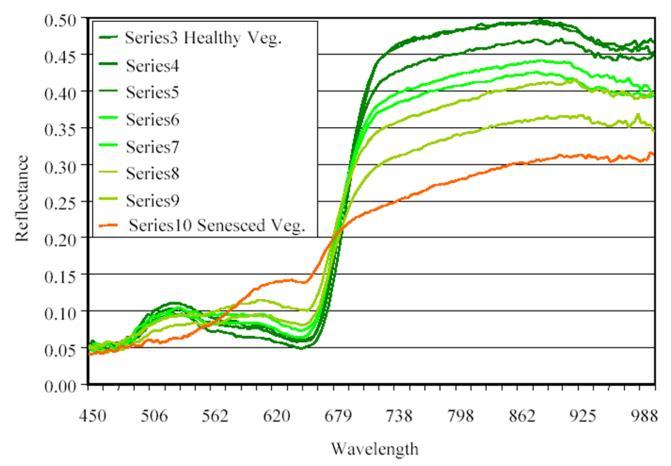
Remote Estimation of Leaf and Canopy Water Content in Winter Wheat with Different Vertical Distribution of Water-Related Properties
 Remote Sens. 2015, 7, 4626-4650; doi:10.3390/rs70404626 Article OPEN ACCESS remote sensing ISSN 2072-4292 www.mdpi.com/journal/remotesensing Remote Estimation of Leaf and Canopy Water Content in Winter
APPLICATIONS USING THE ATMOSPHERIC DATA OF THE PACE MISSION
 APPLICATIONS USING THE ATMOSPHERIC DATA OF THE PACE MISSION Ali H. Omar (NASA) Maria Tzortziou (CCNY), Woody Turner (NASA) Groups/Subgroups: Atmospheric Correction, Applications, Atmospheric by-products
MERIS VALIDATION WITH RESPECT TO OPERATIONAL MONITORING NEEDS IN THE NORTH AND BALTIC SEA
 MERIS VALIDATION WITH RESPECT TO OPERATIONAL MONITORING NEEDS IN THE NORTH AND BALTIC SEA Kerstin Stelzer (1), Jasmin Geißler (1), Carsten Brockmann (1), Holger Klein (2), Jeanette Göbel (3), Anu Reinart
Unmanned Aerial Vehicle (UAV)-Based Remote Sensing for Crop Phenotyping
-Based Remote Sensing for Crop Phenotyping") Unmanned Aerial Vehicle (UAV)-Based Remote Sensing for Crop Phenotyping Sanaz Shafian 1, Nithya Rajan 1, Yeyin Shi 2, John Valasek 3 & Jeff Olsenholler 4 1 Dept. of Soil and Crop Sciences; 2 Dept. of Biological
Unmanned Aerial Vehicle (UAV)-Based Remote Sensing for Crop Phenotyping Sanaz Shafian 1, Nithya Rajan 1, Yeyin Shi 2, John Valasek 3 & Jeff Olsenholler 4 1 Dept. of Soil and Crop Sciences; 2 Dept. of Biological
Innovating on Wide-ranged Ecology Research by Hyper-sensor
 Innovating on Wide-ranged Ecology Research by Hyper-sensor Evaluation of the High-Carbon Reservoirs: Tropical Peatland by Integrated MRV System Kazuyo Hirose *1, Tomomi Takeda *1, Seido Onishi *2, Osamu
Greenhouse Gas Measurements from Space. Chris O Dell Colorado State University
 Greenhouse Gas Measurements from Space Chris O Dell Colorado State University 1 Climate Forcings & Feedbacks Forcings Greenhouse Gases Aerosols Volcanic Eruptions Solar Forcing Temperature Change Feedbacks
SOIL MOISTURE RETRIEVAL FROM OPTICAL AND THERMAL SPACEBORNE REMOTE SENSING
 Comm. Appl. Biol. Sci, Ghent University, 70/2, 2005 1 SOIL MOISTURE RETRIEVAL FROM OPTICAL AND THERMAL SPACEBORNE REMOTE SENSING W.W. VERSTRAETEN 1,2 ; F. VEROUSTRAETE 2 ; J. FEYEN 1 1 Laboratory of Soil
Design of an Agricultural Runoff Monitoring & Incentive System for Maryland
 Design of an Agricultural Runoff Monitoring & Incentive System for Maryland Hoon Cheong, Willie Heart, Lisa Watkins, and Harry Yoo Department of Systems Engineering and Operations Research George Mason
BOTH inherent and apparent optical properties (IOPs and
 1136 IEEE GEOSCIENCE AND REMOTE SENSING LETTERS, VOL. 12, NO. 5, MAY 2015 Influence of Particle Composition on Remote Sensing Reflectance and MERIS Maximum Chlorophyll Index Algorithm: Examples From Taihu
Air pollution monitoring based on remote sensing and simultaneous ground PM 10 and PM2.5 measurements: the WebAir-2 project
 Air pollution monitoring based on remote sensing and simultaneous ground PM 10 and PM2.5 measurements: the WebAir-2 project Hadjimitsis D. G. 1 *, Agapiou A. 1, Themistokleous K. 1, Achilleos C. 1, Nisantzi
Title: CEDEX Proposal for Use. of CHRIS imagery for Monitoring. Authors: Spain) Topic/subtopic
 Topic/subtopic") Title: CEDEX Proposal for Use of CHRIS imagery for Monitoring oring Ecological Water Quality in smallest Mediterranean Reservoirs integrated in the Intercalibration Exercise of WFD Implementation Process
Title: CEDEX Proposal for Use of CHRIS imagery for Monitoring oring Ecological Water Quality in smallest Mediterranean Reservoirs integrated in the Intercalibration Exercise of WFD Implementation Process
Remote Sensing of CO from AIRS AIRS typically sees 82% of the globe each day
 Remote Sensing of CO from AIRS 14 AIRS typically sees 82% of the globe each day From McMillan, et. al., AIRS Science Team Meeting, Spring, 2004 Addressing Aerosol / CO Interactions Sub-Saharan biomass
Developing the next generation of coastal water quality products and services - the FP7/HIGHROC project
 Developing the next generation of coastal water quality products and services - the FP7/HIGHROC project K. Ruddick, C. Brockmann, E. Capuzzo, K. Collingridge, S. Constantin, V. Créach, L. De Keukelaere,
Measurement of water colour using AVIRIS imagery to assess the potential for an operational monitoring capability in the Pamlico Sound Estuary, USA
 International Journal of Remote Sensing Vol. 30, No. 13, 10 July 2009, 3291 3314 Measurement of water colour using AVIRIS imagery to assess the potential for an operational monitoring capability in the
MARINE POLLUTION DEGRADATION MITIGATION MANAGEMENT IS ESSENTIAL FOR IMPROVING MARINE ENVIRONMENT
 MARINE POLLUTION DEGRADATION MITIGATION MANAGEMENT IS ESSENTIAL FOR IMPROVING MARINE ENVIRONMENT The health of the world s oceans and marine life is degrading rapidly as a result of excess human activities.
ACOLITE processing for Sentinel-2 and Landsat-8: atmospheric correction and aquatic applications
 ACOLITE processing for Sentinel-2 and Landsat-8: atmospheric correction and aquatic applications Quinten Vanhellemont, Kevin Ruddick Royal Belgian Institute of Natural Sciences, Operational Directorate
LAND AND WATER - EARTH OBSERVATION INFORMATICS FSP
 Earth Observation for Water Resources Management Arnold Dekker,Juan P Guerschman, Randall Donohue, Tom Van Niel, Luigi Renzullo,, Tim Malthus, Tim McVicar and Albert Van Dijk LAND AND WATER - EARTH OBSERVATION
Measuring canopy nitrogen nutrition in tobacco plants using hyper spectrum parameters
 Measuring canopy nitrogen nutrition in tobacco plants using hyper spectrum parameters Yong Zou, Xiaoqing YE, et al. Shenzhen Tobacco Ind. Co., Ltd. of CNTC Layout Background Experimental Program Experimental
Global Warming and the Hydrological Cycle
 Global Warming and the Hydrological Cycle Climate Change Projections Wet regions will become wetter Dry regions will become drier Precipitation will occur less frequently Precipitation will be more intense
Hyperspectral Remote Sensing of Total Phosphorus (TP) in Three Central Indiana Water Supply Reservoirs
 in Three Central Indiana Water Supply Reservoirs") Water Air Soil Pollut (212) 223:1481 152 DOI 1.17/s1127-11-959-6 Hyperspectral Remote Sensing of Total Phosphorus (TP) in Three Central Indiana Water Supply Reservoirs Kaishan Song & Lin Li & Shuai Li
Water Air Soil Pollut (212) 223:1481 152 DOI 1.17/s1127-11-959-6 Hyperspectral Remote Sensing of Total Phosphorus (TP) in Three Central Indiana Water Supply Reservoirs Kaishan Song & Lin Li & Shuai Li
On SEBI-SEBS validation in France, Italy, Spain, USA and China
 On SEBI-SEBS validation in France, Italy, Spain, USA and China Massimo Menenti Li Jia 2 and ZongBo Su 2 - Laboratoire des Sciences de l Image, de l Informatique et de la Télédétection (LSIIT), Strasbourg,
OMI on board of EOS-Aura OMI TES MLS HIRDLS
 OMI on board of EOS-Aura OMI TES MLS HIRDLS 21 Ozone Monitoring Instrument OMI UV and VIS backscatter instrument (270-500 nm) Wide swath telescope yields daily global maps (2600 km) Urban scale resolution
Trace Gas Performance of Sentinel 4 UVN on Meteosat Third Generation
 Trace Gas Performance of Sentinel 4 UVN on Meteosat Third Generation Heinrich Bovensmann, S. Noël, K. Bramstedt, P. Liebing, A. Richter, V. Rozanov, M. Vountas, J. P. Burrows University of Bremen, Germany
Earth energy budget and balance
 Earth energy budget and balance 31% total reflection (3% clouds. 8% surface) 69% absorption( 0% clouds, 49% surface) Reflection is frequency dependent but will be treated as average value for visible light
20 Global Climate Change
 20 Global Climate Change Overview of Chapter 20 Introduction to Climate Change Causes of Global Climate Change Effects of Climate Change Melting Ice and Rising Sea Level Changes in Precipitation Patterns
Name: Class: Date: 6. Most air pollution is produced by a. thermal inversions. c. ozone layer depletion. b. fuel burning. d. volcanic eruptions.
 Name: Class: Date: Air Test Multiple Choice Identify the choice that best completes the statement or answers the question. 1. Which of the following is often used to remove poisonous gases from industrial
POLLUTION SURVEILLANCE AND DATA ACQUISITION ABSTRACT INTRODUCTION
 Vol. 6, No. 6 WATER RESOURCES BULLETIN November-December 197 POLLUTION SURVEILLANCE AND DATA ACQUISITION USING MULTISPECTRAL REMOTE SENSING Chester T. Wezernak and Fabian C. PoZcyn2 ABSTRACT Large scale
Climate: Earth s Dynamic Equilibrium
 Climate: Earth s Dynamic Equilibrium review session CCIU April 30, 2016 High-school standard HS-ESS2-4 focuses on the role energy flows play in Earth s climate HS-ESS2-4 Use a model to describe how variations
TerraSAR-X Applications Guide
 TerraSAR-X Applications Guide Extract: Change Detection and Monitoring: Forestry April 2015 Airbus Defence and Space Geo-Intelligence Programme Line Change Detection and Monitoring: Forestry Issue Anthropogenic
Estimating Michigan s Trophic State Trends with Satellite Imagery USGS Recent Inland Lake Studies
 Estimating Michigan s Trophic State Trends with Satellite Imagery USGS Recent Inland Lake Studies Lori Fuller USGS Michigan-Ohio Water Science Center 2016 Michigan Inland Lakes Convention April 29, 2016
Study of attenuation depths for MODIS bands in the Bohai Sea in China
 Acta Oceanologica Sinica 2009, Vol.28, No.5, p.39-48 http://www.hyxb.org.cn E-mail: hyxbe@263.net Study of attenuation depths for MODIS bands in the Bohai Sea in China LIU Ying 1,2, LI Guosheng 1 1 Institute
Status and Trends of Water Quality in Wisconsin s Lakes, Streams, and Rivers
 Status and Trends of Water Quality in Wisconsin s Lakes, Streams, and Rivers Tim Asplund, Matt Diebel, Katie Hein, and Mike Shupryt Water Resources Program, WDNR AWRA Wisconsin Section Annual Meeting March
 http://www.photonics.com/article.aspx?aid=60709 HARI VENUGOPALAN, CRYSTAL IS INC. UVC LEDs are fast becoming the technology of choice for designers developing a new breed of spectroscopy devices that are
Status of FerryBox Systems in Europe. Franciscus Colijn and Wilhelm Petersen HZG
 Status of FerryBox Systems in Europe Franciscus Colijn and Wilhelm Petersen HZG History of using Ships of Opportunity (SoOs) for Ocean Monitoring 1853 Brussels Conference: systemizing reporting of marine
Application of Digital Thermal Imaging Cameras for Environmental Analysis
 Application of Digital Thermal Imaging Cameras for Environmental Analysis Mark Landress P.G. Project Navigator, Ltd. 10497 Town & Country Way Suite 830 Houston, TX 77024 www.projectnavigator.com TAEP -
SURFACE REFLECTANCE AND UNDERWATER DOWNWELLING IRRADIANCE IN ALQUEVA RESERVOIR, SOUTHEAST PORTUGAL
 SURFACE REFLECTANCE AND UNDERWATER DOWNWELLING IRRADIANCE IN ALQUEVA RESERVOIR, SOUTHEAST PORTUGAL M. Potes, R. Salgado, M. J. Costa, M. Morais, D. Bortoli and I. Kostadinov Institute of Earth Sciences
SOLAR THERMAL ELECTRICITY GENERATION. By Franz Trieb, Carsten Hoyer, Stefan Kronshage, Richard Meyer, Marion Schroedter-Homscheidt
 SOLAR THERMAL ELECTRICITY GENERATION By Franz Trieb, Carsten Hoyer, Stefan Kronshage, Richard Meyer, Marion Schroedter-Homscheidt 28 Solar Potentials and Markets Power Solar irradiance is the fuel for
Monitoring the Fluctuation of Lake Qinghai Using Multi-Source Remote Sensing Data
 Remote Sens. 2014, 6, 10457-10482; doi:10.3390/rs61110457 Article OPEN ACCESS remote sensing ISSN 2072-4292 www.mdpi.com/journal/remotesensing Monitoring the Fluctuation of Lake Qinghai Using Multi-Source
CONFOUNDING CONSTITUENTS IN REMOTE SENSING OF PHYCOCYANIN
 CONFOUNDING CONSTITUENTS IN REMOTE SENSING OF PHYCOCYANIN Lara Anne Vallely Submitted to the faculty of the University Graduate School in partial fulfillment of the requirements for the degree Master of
1. Introduction. Conference Paper. Mochamad Firman Ghazali 1,2, Agung Budi Harto 1,2, and Ketut Wikantika 3. Abstract
 2nd International Conference on Sustainable Agriculture and Food Security: A Comprehensive Approach Volume 2017 Conference Paper The Simple Method to Assess Land Quality of Paddy Field Using Spectral,
EFFECTS OF ALUM ON THE QUALITY OF AQUACULTURE EFFLUENTS IN SETTLING PONDS
 166 The Israeli Journal of Aquaculture Bamidgeh 56(3), 24, 166-175. EFFECTS OF ALUM ON THE QUALITY OF AQUACULTURE EFFLUENTS IN SETTLING PONDS Martha Rowan1, Amit Gross2* and Claude E. Boyd3 1 Department
Watts in a comfort index:
 Watts in a comfort index: Evaluating pedestrian energy exchange and thermal stress in urban environments David Pearlmutter Desert Architecture & Urban Planning Bona Terra Department of Man in the Desert
ESA Programmes Earth Observation Navigation
 05 March 2007 SSOM Engelberg Lectures R. Hartmann / Eumetsat, Meteosat-8, 28-Jun-2004, VIS+IR ESA Programmes Earth Observation Navigation Urs Frei Swiss Space Office (SSO) SSOM Engelberg Lectures, 05 March
DR1000 Flying Laboratory, Drone Environmental Monitoring
 cccc DR1000 Flying Laboratory, Drone Environmental Monitoring 1 P a g e Mission Statement The Scentroid DR1000 is a fully capable flying laboratory, used to sample and analyze ambient air at heights of
Remotely-Sensed Fire Danger Rating System to Support Forest/Land Fire Management in Indonesia
 Remotely-Sensed Fire Danger Rating System to Support Forest/Land Fire Management in Indonesia Orbita Roswintiarti Indonesian National Institute of Aeronautics and Space (LAPAN) SE Asia Regional Research
16.2 Scanning Infrared Spectrometers
 16.2 Scanning Infrared Spectrometers it's difficult to find materials transparent in the infrared water vapor and atmospheric CO 2 can cause problems there are three common sources high diffraction orders
SCIENCE & TECHNOLOGY
 Pertanika J. Sci. & Technol. 25 (4): 1135-1146 (2017) SCIENCE & TECHNOLOGY Journal homepage: http://www.pertanika.upm.edu.my/ Empirical Ocean Colour Algorithms for Estimating Sea Surface Salinity in Coastal
Arctic shipping activities and possible consequences for the regional climate
 Arctic shipping activities and possible consequences for the regional climate Andreas Massling, Department of Environmental Science, Aarhus University, Roskilde, Denmark Jesper Christensen, Department
Vehicle Remote Sensing - Next Generation - Results. Portable Emissions Measurement Systems International Conference & Workshop
 Vehicle Remote Sensing - Next Generation - Results Portable Emissions Measurement Systems International Conference & Workshop MARCH 26, 2015 A new, patented remote sensing system for vehicle exhaust, based
CTD (CONDUCTIVITY-TEMPERATURE-DEPTH)
") CTD (CONDUCTIVITY-TEMPERATURE-DEPTH) Related lesson plan Fresh and Seawater Density What is this sensor? CTD is an acronym for Conductivity, Temperature and Depth. However, this is somewhat misleading
CTD (CONDUCTIVITY-TEMPERATURE-DEPTH) Related lesson plan Fresh and Seawater Density What is this sensor? CTD is an acronym for Conductivity, Temperature and Depth. However, this is somewhat misleading
The role of Remote Sensing in Irrigation Monitoring and Management. Mutlu Ozdogan
 The role of Remote Sensing in Irrigation Monitoring and Management Mutlu Ozdogan Outline Why do we care about irrigation? Remote sensing for irrigated agriculture What are the needs of irrigators? Future
Optical Coatings. Photonics 4 Luxury Coatings , Genève. Dr. Andreas Bächli Head of Optical Coatings at RhySearch, Buchs (SG)
") Optical Coatings Photonics 4 Luxury Coatings 21.06.2017, Genève Dr. Andreas Bächli Head of Optical Coatings at RhySearch, Buchs (SG) RhySearch The Research- and Innovation Center in the Rhine Valley RhySearch
Optical Coatings Photonics 4 Luxury Coatings 21.06.2017, Genève Dr. Andreas Bächli Head of Optical Coatings at RhySearch, Buchs (SG) RhySearch The Research- and Innovation Center in the Rhine Valley RhySearch
Hydrology and Water Quality. Water. Water 9/13/2016. Molecular Water a great solvent. Molecular Water
 Hydrology and Water Quality Water Molecular Water Exists as an equilibrium But equilibrium altered by what is dissolved in it Water Molecular Water a great solvent In reality, water in the environment
* Author to whom correspondence should be addressed; Tel.:
 Remote Sens. 2013, 5, 1439-1464; doi:10.3390/rs5031439 Article OPEN ACCESS Remote Sensing ISSN 2072-4292 www.mdpi.com/journal/remotesensing Chromophoric Dissolved Organic Matter and Dissolved Organic Carbon
AIRBORNE MAPPING OF VEGETATION CHANGES IN RECLAIMED AREAS AT HIGHLAND VALLEY BETWEEN 2001 AND Gary Borstad, Leslie Brown, Mar Martinez
 AIRBORNE MAPPING OF VEGETATION CHANGES IN RECLAIMED AREAS AT HIGHLAND VALLEY BETWEEN 21 AND 28 1 Gary Borstad, Leslie Brown, Mar Martinez ASL Borstad Remote Sensing Inc, Sidney BC Bob Hamaguchi, Jaimie
Satellite Based Crop Monitoring and Estimation System for Food Security Application in Bangladesh
 Satellite Based Crop Monitoring and Estimation System for Food Security Application in Bangladesh Dr. Hafizur Rahman Head, Agriculture Division Bangladesh Space Research and Remote Sensing Organization
Numerical Modeling of Thermal Bar Evolution in Lake Ontario using the EFDC Model Rumana Reaz Arifin
 Numerical Modeling of Thermal Bar Evolution in Lake Ontario using the EFDC Model Rumana Reaz Arifin 14 th Great Lakes Beach Association Conference November 14, 2014 Layout Introduction EFDC Lake Ontario
Monitoring Lake Simcoe Water Quality using Landsat TM Images
 Monitoring Lake Simcoe Water Quality using Landsat TM Images By Xian Guan A thesis presented to the University of Waterloo in fulfillment of the thesis requirement for the degree of Master of Science in
Annual Deforestation Mapping in Sumatera using multi temporal digital classification
 Annual Deforestation Mapping in Sumatera 1990-2014 using multi temporal digital classification Kustiyo Remote Sensing Technology and Data Center LAPAN International Workshop on Land Use/Cover Change and
HYPOXIA Definition: ~63 µm; 2 mg l -1 ; 1.4 ml l -1 ; 30 %
 HYPOXIA Definition: ~63 µm; 2 mg l -1 ; 1.4 ml l -1 ; 30 % Consequences of hypoxia Reduce habitat for living resources Change biogeochemical processes P released from sediments Denitrification reduced
Planetary Energy Balance
 Planetary Energy Balance Overview of Planetary Energy Balance Energy coming into the Earth s atmosphere from the sun is always in balance with the energy leaving Earth s atmosphere going back out into
S-0163 Revision B. C-sense pco 2 Sensor
 S-0163 Revision B C-sense pco 2 Sensor pco 2 Overview pco 2 is the partial pressure of CO 2 in a given gas sample. In air, pco 2 is ~400-500 ppm (dependent on location, true nature ~400 ppm, in and near
APPLICATIONS OF THE RAPIDEYE RED EDGE BAND
 APPLICATIONS OF THE RAPIDEYE RED EDGE BAND Introduction The Red Edge band is a unique feature that distinguishes RapidEye satellites from most other multispectral satellites. The Red Edge band is located
MIKE 21/3 FLOW MODEL HD FM
 MIKE 21/3 FLOW MODEL HD FM 2D and 3D hydrodynamic modelling using flexible mesh DHI/Photo Simon Mortensen, DHI-AUK component will teach you the fundamentals of 2D and 3D hydrodynamic modelling (HD) and
EUTROPHICATION. Teacher s Manual
 EUTROPHICATION Teacher s Manual Preface The following is a, hands on, and inquiry based lesson plan developed by COSEE Mid-Atlantic for teaching eutrophication. The National Education Science Standards