Sunnyside Heights (Grandview Heights Area #2) Neighbourhood Concept Plan (NCP) - Engineering Servicing and Financial Strategies
|
|
|
- Patrick Dennis
- 6 years ago
- Views:
Transcription
 Neighbourhood Concept Plan (NCP) - Engineering Servicing and Financial Strategies RECOMMENDATION The Engineering Department recommends that Council: 1.")
1 CORPORATE REPORT NO: R236 COUNCIL DATE: November 15, 2010 REGULAR COUNCIL TO: Mayor & Council DATE: November 10, 2010 FROM: General Manager, Engineering FILE: (GH#2) SUBJECT: Sunnyside Heights (Grandview Heights Area #2) Neighbourhood Concept Plan (NCP) - Engineering Servicing and Financial Strategies RECOMMENDATION The Engineering Department recommends that Council: 1. Approve the engineering servicing and related financial strategies as documented in this report and as contained in the Sunnyside Heights (Grandview Heights Area #2) Neighbourhood Concept Plan (NCP) as a means of managing the provision of engineering services for development in this NCP area; 2. Authorize staff to include in the City s 10-Year Servicing Plan the Development Cost Charge (DCC)-eligible infrastructure items for drainage, water and transportation services as documented in Appendix I of this report; and 3. Authorize staff to bring forward a new DCC By-law that includes an adjustment to the Highway 99 Corridor area specific DCC rate as part of the next DCC update. INTENT The purpose of this report is to provide: Council with an overview of the engineering servicing and related financial strategies for the Sunnyside Heights (Grandview Heights Area #2) NCP; and Support the Sunnyside Heights (Grandview Heights Area #2) Stage 2 Final Report, which is to be forwarded for consideration by Council at the same meeting as this report is to be considered. BACKGROUND Council approved in principle the Stage 1 Land Use Concept Plan for Sunnyside Heights (Grandview Heights Area #2) at its Regular meeting on July 23, Staff noted at that time that there were a number of engineering and financial issues to be resolved as part of the Sunnyside Heights NCP - Stage 2 process. The Sunnyside Heights NCP Stage 2 report has been completed based on the approved Land Use Concept Plan.
2 - 2 - DISCUSSION An engineering servicing analysis and financial plan for the Sunnyside Heights NCP has been completed. Only those works that normally form part of the City s DCC program, such as major trunk sewer and water grid mains, major collector and arterial roads, and major stormwater management infrastructure, are discussed in detail in this report. The report does not address localized site servicing as that servicing will be addressed on a site by site basis by individual development applicants in conjunction with their application approval process as is normal for all development applications in NCP areas. The only exception is the on-site stormwater management controls that will be specified in the NCP for all developments in the NCP and reflect new stormwater best management practices. Water The NCP area is partially serviced with small diameter water mains. A new network of distribution mains and pressure reducing stations will be required in the area. The topography of the NCP requires that two separate pressure zones (142m & 110m) be established. Water supply to the 132m zone that is generally above 70-75m elevation contour will be provided from the existing Grandview Pump Station and feeder mains on 24 Avenue. The pump station and the feeder mains have been designed to allow for their use in servicing this NCP. The lower 110m pressure zone will ultimately be serviced from the Grandview reservoir by way of a proposed 600mm gravity main on 24 Avenue and an existing 500mm gravity feeder main along the 164 Street corridor. The watermain network will be developed to reflect the phasing of development applications. Transportation The transportation plan for Sunnyside Heights NCP has been developed based on the guiding principles contained in the City s Transportation Strategic Plan. A modified grid road system will create a liveable urban community. The proposed modified grid street system takes into account property lines, tree protection, environmental protection and topography. When combined with the network of greenways and public lanes, the road system supports good internal circulation providing residents with safe continuous routes to walk or cycle to schools, parks and other services and facilities in the area. The road network has been designed to provide connectivity and integration with the transportation network in the surrounding areas and supports the reasonable dispersion of traffic throughout the neighbourhood. On-street parking will be permitted on most of the residential streets within the NCP while collector roads like 164 Street and 20 Avenue will provide opportunities for future transit service within the neighbourhood. The planned road network provides a grid system and level of street connections comparable with other NCPs including East Clayton, Clover Valley Station and Panorama, and establishes block sizes in the range of 100/150m by 200m, which are considered reasonable for development while allowing for a walkable community.
3 - 3 - Residential street connectivity and spacing provides for interesting, safe and friendly place making public open spaces. Multi-family sites are planned as open communities that blend with the adjacent land uses. Some of the residential local roads are shown as Flex Roads to highlight the need for connectivity but allow flexible alignments and/or cross sections to address tree protection or other matters that are important to building a great neighbourhood. Analysis has shown that the proposed road network will accommodate the projected traffic volumes from the proposed land uses including overall background traffic growth. The NCP area is bounded by three arterial roads: 16 Avenue to the south, 24 Avenue to the north and 168 Street to the east. As identified through the City s South Surrey Traffic Model, to accommodate the traffic volumes of development in this NCP area and the South of Fraser region, 24 Avenue and 16 Avenue are each planned for widening to a six-lane cross-section in the future. 24 Avenue has already been identified as a future Frequent Transit Network route by TransLink, and the right-ofway width being protected will allow for the implementation of higher order transit service (i.e., Bus rapid transit (BRT), LRT or street car) along this corridor. Four-lane cross-sections on 168 Street and on 20 Avenue west of 164 Street will be sufficient to satisfy projected future traffic demand. The required road allowances will be dedicated to the City as the adjacent lands develop. Sanitary Sewer There is no City sanitary sewer system in the NCP area at the present time. The nearest City sewer with capacity is at 160 Street and 24 Avenue, which was sized to receive the sewer flow from this NCP area. The topography of the area includes a ridge line that runs in an east-west direction at about 24 Avenue with a moderate slope toward the south. The north-eastern half of the NCP can be serviced by gravity via a trunk sewer following the slope to the existing sewer invert level at 24 Avenue and 160 Street. The remaining southern and western half of the NCP area will be serviced by means of a future pump station located approximately in the 1400 block of 168 Street, which will pump sewage to the north to the sewer at 24 Avenue and 160 Street. Stormwater Sunnyside Heights NCP is located within the Fergus Creek watershed. Fergus Creek drains toward the Campbell River and then into Semiahmoo Bay. Fergus Creek is a fish-bearing watercourse with some areas where downstream erosion is evident. In advance of the NCP planning process, the Engineering Department completed the Fergus Creek Integrated Stormwater Management Plan (ISMP). The work associated with developing the ISMP included an investigation of the watershed with the goal of facilitating development while protecting the environment by integrating land use planning with stormwater engineering, flood and erosion protection, and environmental protection. The most significant recommendation from the ISMP was the need for the introduction of enhanced infiltration systems in the NCP, as traditional stormwater detention ponds were not considered to be appropriate in the context of providing significant stream base flow augmentation nor would they address downstream erosion concerns.
4 - 4 - In order to achieve urban forms of density in an open watercourse area to meet the needs identified in the ISMP, the stormwater system for Sunnyside Heights NCP will consist of an interrelated set of private (on-site) and public storm water controls including storm water corridors, perforated local storm drains, and landscape-based low impact source controls on individual lots. 1. On-Site Stormwater Management Controls On-site stormwater management controls will be incorporated into each development site within the NCP area. The intent is to maximize infiltration and evapo-transpiration of rainwater. The following table summarizes the required on-site controls by proposed land use. Land Use On-Site Stormwater Management Control Requirements Single-family Residential A minimum 150 mm depth of amended topsoil on pervious (landscape) areas. Multi-family Residential, A minimum 150 mm depth of amended topsoil on pervious Commercial, and Institutional (landscape) areas. On-site runoff storage equal to 150 m3/ha of gross site area released at a rate of L/s/ha or L/s/ha dependent on location within the NCP. Water quality treatment for any specific high risk contaminants associated with the site s land use activities 2. Stormwater Corridors A network of stormwater infiltration corridors distributed across the area varying in width from 5m to 20m is proposed for this NCP area, which differs significantly from traditional stormwater detention ponds. Stormwater corridors are being proposed as they have the advantage of reducing total runoff volume, which is not achieved by traditional stormwater management techniques. This reduced runoff volume acts to mitigate the potential for downstream erosion. Stormwater Management Approach Peak Flow Control Runoff Volume Control Water Quality Treatment Base Flow Augmentation Detention Pond yes no yes no Stormwater Corridors yes yes yes yes Approximately 80% of the proposed stormwater corridors are 5m wide, approximately 20% are 10m wide, and only a few segments are 20m wide. This is a refinement of the Fergus ISMP as the stormwater corridors are more practical than the proposed green corridors which concentrated the impact to a few significant corridors that had a proposed width of 40m. Each of the proposed stormwater corridors is identified in the NCP document and can include: Bioswales to promote infiltration and provide runoff treatment; Sub-surface storage and perforated underdrains to promote infiltration; Amended topsoils; and Trees.
5 - 5 - Stormwater corridors are located throughout the NCP area to capture as much of the runoff as possible and provide volume reduction, peak attenuation, and water quality treatment without the need for traditional detention ponds. In all, approximately 5% of the land area will be used for infiltration corridors. 3. Perforated Storm Drains Perforated storm drain systems will be installed under local residential streets to maximize the potential for stormwater infiltration. A perforated storm drain is laid parallel to the storm sewer pipe tying into the manholes. This storm drain system promotes infiltration during drier months but also conveys runoff during wet weather months when the capacity for infiltration through the perforated pipe is exceeded by the incoming storm water flows. 4. Detention Pond Option Although the proposed infiltration system has clear advantages, there may be limited opportunity within the NCP area to introduce stormwater detention, in place of the infiltration system, and still meet the objectives identified in the ISMP. A potential location for a detention pond is the southwest corner of 20 Avenue and the existing 164 Street alignment. This detention pond would service an area of 35 ha. The cost difference between the stormwater corridors in this area and the proposed pond is $0.7 million. Other opportunities to introduce a second pond in this area were also examined, but found to cost more than $3.0 million more than the stormwater corridor option. As a result, as it is economically feasible to manage stormwater either through corridors or by a detention pond in this area, both options have been provided to allow the greatest flexibility for the future development of this area. Other opportunities to introduce detention ponds elsewhere in the NCP area were evaluated, but these were found to be cost prohibitive. Financial Analysis A comprehensive financial analysis is included in the NCP engineering report. The following table summarizes the projected DCC revenues and construction costs for the infrastructure needed to provide trunk engineering services to and in the NCP area. The revenues are based on the current DCC rates for each land use category as proposed in the NCP Land Use Concept. Services Estimated DCC Total Estimated DCC Revenues Expenditures Balance Sanitary Sewer $7,434,000 $12,523,000 -$5,089,000 Water $4,335,000 $3,027,000 $1,308,000 Drainage $6,710,000 $25,203,000 -$18,493,o00 Non-Arterial Streets $5,370,000 $3,674,000 $1,696,000 Arterial Streets $24,576,000 $13,250,000 $11,326,000 Appendix I lists the 10 Year Servicing Plan Projects required for this NCP and the DCC-eligible cost component for drainage, water and transportation infrastructure for this NCP area that should be included in the City s 10-Year Servicing Plan.
6 - 6 - The arterial DCC balance will be used to assist in funding other road improvements some of which will ultimately be required for and provide benefit to this NCP area, such as the planned future interchanges at 16 Avenue and 24 Avenue, which will be very costly. Financing of Sanitary Sewer System As previously referenced in this report, the NCP area is divided into areas relative to the means by which sanitary sewer service will be provided. Sanitary Service Area 1, as illustrated in Appendix II will be serviced by gravity sewers without the need for pumping, while Sanitary Service Area 2 will be serviced by way of gravity sewers and a pump station and related force main. This pump station in Sanitary Service Area 2 will also service other areas surrounding the NCP area, including parts of the Highway 99 Corridor NCP and future development in Grandview NCP Areas #3 and #5. The Pump Station is proposed to be phased to meet present servicing needs with the possibility for efficient capacity upgrades in the future. After reviewing the DCC contribution from the Highway 99 Corridor NCP based on expected flows, it was determined that a DCC rate adjustment is necessary for the Highway 99 Corridor area in relation to the contributory flows that will be generated by development in that area. As a result, an adjustment to the Highway 99 Corridor area specific DCC rates will be necessary to account for the revised sanitary servicing costs. Staff, as part of the annual DCC review process, are planning to bring forward a new DCC By-law for Council s consideration by the end of this year. After factoring the appropriate contributions from the benefitting areas of the Highway 99 Corridor NCP, there is a DCC shortfall in the Sanitary Service Area 2 of the Sunnyside Heights NCP. To overcome this shortfall it will be necessary for developers in the area to use one of the following tools: 1. A DCC Front-enders Agreement over the entire sanitary service area; 2. A Development Works Agreement over Sanitary Service Area 2. A Development Works Agreement requires the consent of a majority of the owners of the properties located within the benefitting sanitary service catchment area. Based on the net developable area of each of the above-referenced sanitary service areas in the Sunnyside Heights NCP, the value of the Development Works Agreement is estimated as follows: Sanitary Service Area Servicing Cost Total Estimated DCC Revenues Balance (DWA Value or DCC Adjustment) Approximate Charge Per Acre Per Unit (1) 1 (upper) $1,518,000 $1,518,000 $0 $0 $0 2 (lower) $6,669,000 $4,135,000 $2,534,000 (2) $20,500 $1,710 Hwy. 99 $4,336,000 $1,781,000 $2,555,000 (3) $12,775 n/a (1) Based on 12 units per acre for comparative purposes (2) DWA Value (3) DCC Adjustment
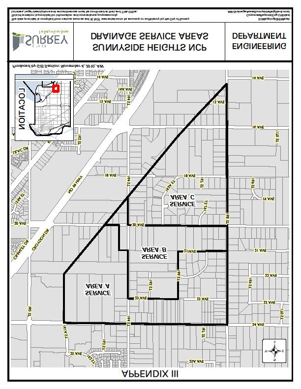
7 - 7 - The approximate DWA charge detailed above is based on the preliminary boundary between sanitary service areas. A detailed review of this boundary will be undertaken in conjunction with a DWA application and will require more detailed engineering analysis. If sufficient property owner support is not achieved to proceed with a Development Works Agreement, the front ending developer will have the choice of: moving forward with the project and absorbing the short fall; re-initiating the voting process with new boundaries; or deciding not to move forward with the project. There are no legislative constraints related to re-initiating a Development Works Agreement vote or the number of times that such a vote can be undertaken. Financing of Stormwater Corridors Originally, a stormwater management scheme was proposed that required the dedication of up to 5m of stormwater corridor area along almost all of the streets within the NCP area; however, the development industry has advised that the applicants making such dedications for stormwater purposes should be compensated for these areas so as to equalize the burden across development in the NCP. This will be accomplished by means of an area charge. As there is the potential to introduce a stormwater detention pond in one sub-area of the NCP, the NCP area has been divided into three drainage service areas. These areas are identified in Appendix III. By compensating the developers in the area for the stormwater corridors, the value of the DCC drainage expenditures increases from $6.6 million to $25.2 million, based on a maximum reimbursement of $750,000 per acre. To overcome this shortfall developer(s) will be required to frontend the stormwater corridors within their development and recover the costs of these corridors through: 1. A DCC Front-enders Agreement for the drainage service area; and 2. A Development Works Agreement for the drainage service area. A Development Works Agreement requires the consent of the owners of properties within the benefitting service area. Based on the net developable area of each drainage service area, the value of the Development Works Agreement for each area is estimated as documented in the following table:
8 - 8 - Drainage Service Area A (upper) B (central) C (lower) Stormwater Management Approach Stormwater Corridors Detention Pond or Stormwater Corridors Stormwater Corridors Servicing Cost Estimated DCC Revenues Balance (DWA Value) Approximate DWA Charge Per Acre Per Unit (1) $11,020,000 $3,411,000 $7,609,000 $83,500 $7,000 $7,000,000 $1,119,000 $5,881,000 $122,000 $10,200 $7,183,000 $2,180,000 $5,003,000 $56,500 $4,700 (1) Based on 12 units per acre for comparative purposes If the front-ending developer is not successful in achieving sufficient support for a Development Works Agreement, the developer will have the choice of: moving forward with the project and absorbing the short fall; re-initiating the voting process with new boundaries or owners; or deciding not to move forward with the project. There are no legislative constraints related to re-initiating a Development Works Agreement vote or the number of times that such a vote can be undertaken. Engineering Services Financial Strategy As outlined above, the engineering services financial strategy for the Sunnyside Heights relies on a combination of development cost charges, DCC Front-enders Agreements, and Development Works Agreements. These various mechanisms are necessary to finance the required services in order to ensure costs are distributed equitably over the benefitting area, and to minimize the investment that any one developer needs to make. Although this financial strategy may seem complicated, it is a strategy that is not unique, and one that the City has applied in recent greenfield development areas such as Grandview Heights Area 1 Morgan Heights, and the Douglas NCP area. Development Phasing New development must connect to a City sanitary sewer system. Those properties that can be connected to the City s sanitary sewer system by gravity (sanitary service area 1) will likely be easier to develop than the properties that require the installation of a pump station (sanitary service area 2).
9 - 9 - Energy Management In addition to the traditional engineering servicing included as part of the Sunnyside Heights NCP, staff have commenced an evaluation of energy management opportunities for all the City s NCP areas. Staff is pursuing the potential to develop a geo-exchange heating system and LED street lighting in this NCP area. 1. Geo-exchange Heating System Based on a preliminary evaluation it appears that geoexchange heating systems for individual developments in this NCP area are technically feasible and financially viable. Staff will be contacting the development community in this area to provide a copy of the geoexchange report and to alert them to the benefits of the alternative energy sources available in the area. 2. Light Emitting Diode (LED) Street Lighting LED street lighting is a rapidly evolving technology that offers significant power savings over conventional street lights. The Engineering Department is recommending that all street lights in this NCP area be LED street lights. There is currently about a $750 premium per lamp for these types of street lights but prices are steadily dropping. The Engineering Department is currently evaluating a number of alternatives and will be able to identify one or more products suitable for installation in short order. Staff will also be exploring opportunities with suppliers to reduce the cost of the LED street lights for installations within this new neighbourhood.
10 CONCLUSION The infrastructure proposed in this report will support the land use proposed in the Sunnyside Heights (Grandview Heights Area #2) NCP. The financial strategy as proposed is in accordance with Council s policy; namely, the development-pay principle and requiring each NCP to be financially self-sufficient. Based on the above discussion, the Engineering Department recommends that Council: Approve the engineering servicing and related financial strategies as documented in this report and as contained in the Sunnyside Heights (Grandview Heights Area #2) Neighbourhood Concept Plan (NCP) as a means of managing the provision of engineering services for development in this NCP area; Authorize staff to include in the City s 10-Year Servicing Plan the Development Cost Charge (DCC)-eligible infrastructure items for drainage, water and transportation services as documented in Appendix I of this report; and Authorize staff to bring forward a new DCC By-law that includes an adjustment to the Highway 99 Corridor area specific DCC rate as part of the next DCC program update. Appendix I - 10-Year Servicing Plan Projects Appendix II - Sanitary Service Areas Appendix III - Drainage Service Areas JB/JA/JML/jkb/brb Vincent Lalonde, P.Eng. General Manager, Engineering g:\wp-docs\2010\administration\cr\ jml.docx BRB 11/12/10 7:05 AM
11 APPENDIX I 10-Year Servicing Plan Projects The projects listed in the following tables are eligible to be included into the 10-Year Servicing Plan. Drainage Project Project Cost Growth Non-Growth Cost Cost Component Component (DCC) Trunks $3,546,000 $0 $3,546,000 Ditch Erosion Protection $63,900 $0 $63,900 Bioswale construction in $917,600 $0 $917,600 medians Stormwater Corridors - Area A $3,343,000 $0 $3,343,000 Stormwater Corridors - Area C $2,027,000 $0 $2,027,000 Stormwater Corridors or Detention Pond - Area B $1,345,000 $0 $1,345,000 Water Project Project Cost Non-Growth Cost Component Growth Cost Component (DCC) PRV at 17/163 $75,000 $0 $75,000 Circulation PRVs, various $40,000 $0 $40,000 locations 200m of 350mm dia watermain $154,000 $68,000 $86, St: 23 & 24 Ave 200m of 350mm dia watermain $154,000 $68,000 $86, St: Ave 200m of 300mm dia watermain $148,000 $0 $148, Ave: St 200m of 300mm dia watermain $148,000 $0 $148, Ave: St 200m of 300mm dia watermain $148,000 $66,000 $82, Ave: St 100m of 300mm dia watermain $74,000 $33,000 $41, Ave: 161A St 100m of 300mm dia watermain $74,000 $33,000 $41,000-23A Ave: 161A St 100m of 300mm dia watermain $74,000 $33,000 $41, St: 23A - 24 Ave 100m of 300mm dia watermain $74,000 $33,000 $41,000-20A Ave: A St 100m of 300mm dia watermain - 17 Ave: 167A-168 St $74,000 $33,000 $41,000
12 - 2 - Sewer Project 300m of 675mm - 24 Ave:160 St to 161A St (Area 1) 360m of 375mm - From 22 Ave/163A St to 21 Ave/165 St (Area 1) 125m of 450mm - From 22 Ave/163A St to 22A/163St (Area 1) Sanitary Sewer Upsizing - North Catchment (Area 1) 100m of 525mm St: from 14 Ave to 14A Ave (Area 2) 280m of 375mm - Along BC Hydro ROW from 16 Ave to 17 Ave (Area 2) Sanitary Sewer Upsizing - South Catchment (Area 2) Grandview South Pump Station and Forcemain (Area 2 Component) Grandview South Pump Station and Forcemain (Hwy 99 Component) Project Cost Non-Growth Cost Component Growth Cost Component (DCC) $459,000 $0 $459,000 $390,000 $0 $390,000 $148,000 $0 $148,000 $521,000 $0 $521,000 $164,000 $0 $164,000 $305,000 $0 $305,000 $436,000 $0 $436,000 $3,230,000 $0 $3,230,000 $4,336,000 $0 $4,336,000 Transportation Arterial Project Project Cost Non-Growth Cost Component Growth Cost Component (DCC) Arterial Widening (to 5 lanes) - $8,400,000 $0 $8,400, Avenue: Street Traffic Signal - 24 Avenue / 162 $150,000 $0 $150,000 Street Total $8,550,000 $0 $8,550,000 Collector Project Project Cost Non-Growth Cost Component Growth Cost Component (DCC) Traffic Signal - 24 Avenue / 164 $150,000 $0 $150,000 Street Roundabout 20 Avenue / 164 $1,534,000 $0 $1,534,000 Street Traffic Signal 20 Avenue / 168 $150,000 $0 $150,000 Street Total $1,734,000 $0 $1,734,000
13
14
GRAND NIAGARA Proposed Secondary Plan
 GRAND NIAGARA Proposed Secondary Plan Public Open House #3 January 17. 2017 scope + process BUILT Grand Niagara Secondary Plan The Grand Niagara Secondary Plan will establish a framework for the future
TES Industrial Development SW ¼ SEC Lacombe County Outline Plan
 TES Industrial Development Lacombe County Outline Plan 112849297 June 2012 am v:\1128\active\112849297\07_reports_studies\rpt_tes_20120508.doc i Table of Contents 1.0 INTRODUCTION... 1 1.1 PURPOSE... 1
The Lakes District and Schooner Cove Integrated Stormwater Management Plan Kerr Wood Leidal, Draft Report, July 2012 (revised October 2013)
") To: Jeremy Holm, Regional District of Nanaimo cc: Geoff Garbutt, Regional District of Nanaimo From: Dan Huang / Ehren Lee 1.0 INTRODUCTION Urban Systems has been asked to assist the Regional District of
To: Jeremy Holm, Regional District of Nanaimo cc: Geoff Garbutt, Regional District of Nanaimo From: Dan Huang / Ehren Lee 1.0 INTRODUCTION Urban Systems has been asked to assist the Regional District of
Development in the City of Toronto
 Development in the City of Toronto Water Infrastructure Challenges and Opportunities Graham Harding, P.Eng. Toronto Water, City of Toronto Urban Land Institute Leadership Program February 16, 2017 Toronto
STORM WATER MANAGEMENT REPORT
 Silvercreek Junction STORM WATER MANAGEMENT REPORT Howitt Creek at the Silvercreek Parkway Site Guelph, Ontario August, 2008 TSH File 22304A-04 August 19, 2008 STORMWATER MANAGEMENT REPORT Howitt Creek
E. STORMWATER MANAGEMENT
 E. STORMWATER MANAGEMENT 1. Existing Conditions The Project Site is located within the Lower Hudson Watershed. According to the New York State Department of Environmental Conservation (NYSDEC), Lower Hudson
Sewer System Flood Reduction Measures in the Rockcliffe Area
 PW28.6 REPORT FOR ACTION Sewer System Flood Reduction Measures in the Rockcliffe Area Date: March 26, 2018 To: Public Works and Infrastructure Committee From: General Manager, Toronto Water Wards: Ward
Municipal Stormwater Ordinances Summary Table
 APPENDIX F Municipal Ordinances Summary Table Municipality Abington Bryn Athyn Borough Hatboro Borough Ordinance, SALDO Runoff equals pre post Erosion Sediment Control Water Quality Requirements Any which
UNIVERSITY OF OREGON NORTH CAMPUS CONDITIONAL USE PERMIT PROJECT Draft Conditional Use Permit Stormwater, Sanitary Sewer, and Water Analysis Report
 UNIVERSITY OF OREGON NORTH CAMPUS CONDITIONAL USE PERMIT PROJECT Draft Conditional Use Permit Stormwater, Sanitary Sewer, and Water Analysis Report Prepared for: Cameron McCarthy Landscape Architects LLP
SECTION 3 DRAINAGE. 3-1 General. 3-2 Drainage Ordinances and Legal Requirements
 SECTION 3 DRAINAGE 3-1 General All Drainage plans for proposed development shall be prepared by a Professional Engineer registered in Virginia, except as noted below. Further, their seal and signature
Julia Bahen, Urban Strategies Inc.
 THE MUNICIPAL INFRASTRUCTURE GROUP LTD. 8800 Dufferin Street, Suite 200 Vaughan, Ontario L4K 0C5 T 905.738.5700 F 905.738.0065 www.tmig.ca TECHNICAL MEMORANDUM DATE June 13, 2017 TO CC SUBJECT FROM PROJECT
Municipality of Kincardine Kincardine Business Park (KBP) Servicing Master Plan
 Servicing Master Plan") Municipality of Kincardine Kincardine Business Park (KBP) Servicing Master Plan Public Meeting and Open-House March 27, 2013 Agenda The Master Plan Process History of the Area Draft Servicing Strategy
Municipality of Kincardine Kincardine Business Park (KBP) Servicing Master Plan Public Meeting and Open-House March 27, 2013 Agenda The Master Plan Process History of the Area Draft Servicing Strategy
Storm Water and Sanitary Sewer
 Public Works Department Summary Report on Planned Capital Improvements Storm Water and Sanitary Sewer Introduction Public Works has assembled this summary report to highlight major capital improvements
What is a stormwater utility fee?
 What is a stormwater utility fee? A stormwater utility fee is similar to a water or sewer utility fee. In essence, customers pay a fee to convey stormwater from their properties. The City of Goodlettsville
Surface Water Drainage Pro-forma for major developments
 Surface Water Drainage Pro-forma for major developments We advise that developers complete this form and submit it to the Local Planning Authority with their planning application, referencing from where
DEVELOPMENT ENGINEERING REVIEW MANUAL (Regional Services)
") DEVELOPMENT ENGINEERING REVIEW MANUAL (Regional Services) FEBRUARY, 2005 PLANNING AND TRANSPORTATION SERVICES PLANNING AND PUBLIC WORKS DEPARTMENT TABLE OF CONTENTS Introduction 1 Application Review 1.1
DEVELOPMENT ENGINEERING REVIEW MANUAL (Regional Services) FEBRUARY, 2005 PLANNING AND TRANSPORTATION SERVICES PLANNING AND PUBLIC WORKS DEPARTMENT TABLE OF CONTENTS Introduction 1 Application Review 1.1
Reducing Flood Risk in Toronto. David Kellershohn, M.Eng., P. Eng. Toronto Water, City of Toronto
 Reducing Flood Risk in Toronto David Kellershohn, M.Eng., P. Eng. Toronto Water, City of Toronto Institute for Catastrophic Loss Reduction February 19, 2016 1 Agenda Reducing Flood Risk in Toronto 1) Overview
Learning objectives. Upon successful completion of this lecture, the participants will be able to:
 Solomon Seyoum Learning objectives Upon successful completion of this lecture, the participants will be able to: Describe and perform the required step for designing sewer system networks Outline Design
Regional District of Okanagan-Similkameen 101 Martin Street Penticton, BC V2A 5J9. November 2008 Project No
 Sawmill Road Area Sanitary Sewer Feasibility Study Regional District of Okanagan-Similkameen 101 Martin Street Penticton, BC V2A 5J9 November 2008 Project No. 104258 Table of Contents SECTION TITLE PAGE
Factor Potential Effects Mitigation Measures
 Natural Environment No impacts of provincial significance to the natural environment are anticipated for the rapid transit project. Other impacts and how they will be mitigated are outlined in the table
Chapter 7. Street Drainage. 7.0 Introduction. 7.1 Function of Streets in the Drainage System. 7.2 Street Classification
 7. Introduction This chapter summarizes methods to evaluate runoff conveyance in various street cross sections and curb types in the Town of Castle Rock and identifies acceptable upper limits of street
CHAPTER 6 COLLECTION SYSTEM HYDRAULIC MODEL
 CHAPTER 6 COLLECTION SYSTEM HYDRAULIC MODEL INTRODUCTION The District developed a hydraulic model of the sanitary sewer system as part the 2000 Wastewater Comprehensive Plan. The output from this model
S.O.P. No. HMD
 Page: 1 of 9 PURPOSE: To establish (SOP) for submission requirements, review process and approval of applications for Non-vehicular Access Permits for the purpose of connection or discharge to any MassDOT
STREAM AND BUFFER AREA PROTECTION/RESTORATION
 STREAM AND BUFFER AREA PROTECTION/RESTORATION AMENDMENT OPTIONS TO STRENGTHEN POLICY IN HEADWATERS AREAS DRAFT SUBSEQUENT TO THE JANUARY 25, 2007 MEETING OF THE PLANNING COMMISSION ENVIRONMENT COMMITTEE
SEWER SYSTEM DESIGN GUIDELINES
 SEWER SYSTEM DESIGN GUIDELINES PART 1 GENERAL 1.1 GENERAL GUIDELINES A. The following sewer system design guidelines are based on Federal, State and Local health requirements, and the Berkeley County Water
SPRINGBANK Phase 1 Background Report
 Phase 1 Background Report Table of Contents 1.0 CONTEXT... 4 CENTRAL ASP... 4 NORTH ASP... 4 MODDLE ASP... 5 2.0 PROJECT SCOPE... 5 3.0 PLANNING POLICY FRAMEWORK... 6 COUNTY PLAN (BYLAW C-7280-2013)...
The rezoning application and proposed transportation facility warrants consideration.
 Date: November 11, 2014 To: Re: Chair and Members Planning & Development Committee PDE File Number: REZ1400020 275 Conception Bay South Bypass Road, Ward 5 Application to Rezone Land to Industrial General
DESIGN AND CONSTRUCTION OF DERRY ROAD AND CANADIAN NATIONAL RAIL GRADE SEPARATION
 DESIGN AND CONSTRUCTION OF DERRY ROAD AND CANADIAN NATIONAL RAIL GRADE SEPARATION Vireak Hinh, P.Eng. R.V. Anderson Associates Ltd., Toronto, Canada Jennifer Trimble Region of Halton, Oakville, Canada
Attachment A: TransformTO Short-term Strategies
 Attachment A: Short-term Strategies PE15.1 Attachment A 1. Supporting energy efficiency in buildings Expand current programs to reduce energy use in houses, multi- residential and other buildings. This
Comox. Valley A. Rainwater Benefits. Six
 Comox Valley Local Governments Showcase A Regional Response to Infrastructure Liability Rainwater Management in a Watershed Context: Do More With Less & Achieve Stream Health Benefits Six in a series published
SECTION STORM DRAINAGE DESIGN, GRADING, AND WATER QUALITY TECHNICAL CRITERIA TABLE OF CONTENTS PAGE 402 STORM DRAINAGE DESIGN CRITERIA 400-1
 CITY OF THORNTON Standards and Specifications Revised: October 2012 SECTION 400 - STORM DRAINAGE DESIGN, GRADING, AND WATER QUALITY TECHNICAL CRITERIA TABLE OF CONTENTS PAGE 401 GENERAL PROVISIONS 400-1
City of Brantford Chapter 3 TABLE OF CONTENTS
 Chapter 3 The Land Use & Transportation Connection TABLE OF CONTENTS 3.1 THE LAND USE & TRANSPORTATION LINK... 1 3.2 POPULATION & EMPLOYMENT GROWTH FORECASTS... 3 3.2.1 Proposed Places to Grow Plan Forecasts
D. B. G R A Y E N G I N E E R I N G I N C.
 SERVICING BRIEF Mutchmor Public School Addition 185 Fifth Avenue Ottawa, Ontario Report No. 12073-SB February 15, 2013 D. B. G R A Y E N G I N E E R I N G I N C. Stormwater Management - Grading & Drainage
10.0 Storm Sewer Systems
 October 2003 Chapter 10.0, Storm Sewer Systems Page 1 10.0 Storm Sewer Systems 10.1 Introduction A storm sewer system consists of a system of inlets, pipes, manholes, junctions, cleanouts, outlets, and
Stormwater Management Studies PDS Engineering Services Division ES Policy # 3-01
 Stormwater Management Studies PDS Engineering Services Division Revised Date: 2/28/08 INTRODUCTION The City of Overland Park requires submission of a stormwater management study as part of the development
FUN NCTIONAL SER RVICING AN ND STO R MA ORMWATER ANAGEMENT PREPARED FOR: CITY O 333 AN REET EAST ND 351 KING STR OF TORONTO VICTORIA PA
 FUN NCTIONAL SER RVICING AN ND STO ORMWATER R MA ANAGEMENT T RE PORT 333 AN ND 351 KING STR REET EAST P PREPARED FOR: CITY O OF TORONTO F IRST GULF COR PORATION 3 751 VICTORIA PA ARK AVENUE T TORONTO,
THE CROSSROADS IN WINCHESTER 4. DRAINAGE PLAN. 4. Drainage Plan. a. Drainage Plan Description
 THE CROSSROADS IN WINCHESTER 4. DRAINAGE PLAN 4. Drainage Plan a. Drainage Plan Description The Specific Plan area drains naturally into two separate watersheds: approximately 6 percent of the Specific
Stormwater Local Design Manual For Houston County, Georgia
 Stormwater Local Design Manual For Houston County, Georgia Adopted November 15, 2005 TABLE OF CONTENTS 1. FORWARD... 1 2. GENERAL LEVEL OF SERVICE STANDARDS... 2 2.1. DETENTION REQUIREMENTS... 2 2.1.1.
Water Balance Methodology
 Water Balance Methodology Integrating the Site with the Watershed and the Stream March 2012 An initiative under the umbrella of the Water Sustainability Action Plan for British Columbia Water Balance Methodology
XI. Thornton Planning Area
 XI. A. OVERVIEW The covers 120 square miles in the northwest corner of San Joaquin County. It consists primarily of low-lying Delta islands, sloughs, and large farms. The town of Thornton, a small agriculturally-based
Attachment 12 Stage 1 Flood Risk Assessment (IE RP-0001)
") IE0311133-22-RP-0001, Issue A 17/10/2013 Attachment 12 Stage 1 Flood Risk Assessment (IE0311133-30-RP-0001) IE0311133-22-RP-0001_A_02.DOC Flood Risk Assessment Celebrating 40 Years in Business Jazz Pharmaceuticals
IE0311133-22-RP-0001, Issue A 17/10/2013 Attachment 12 Stage 1 Flood Risk Assessment (IE0311133-30-RP-0001) IE0311133-22-RP-0001_A_02.DOC Flood Risk Assessment Celebrating 40 Years in Business Jazz Pharmaceuticals
Chapter 6. Hydrology. 6.0 Introduction. 6.1 Design Rainfall
 6.0 Introduction This chapter summarizes methodology for determining rainfall and runoff information for the design of stormwater management facilities in the City. The methodology is based on the procedures
STORMWATER AND EROSION CONTROL PERMIT
 STORMWATER MANAGEMENT AND EROSION CONTROL PERMIT INSTRUCTIONS AND INFORMATION Any project that involves the disturbance of ANY quantity of land requires the applicant to receive approval for the project
INSTRUCTIONS FOR SUBMITTING A COMMERCIAL SEWAGE DISPOSAL PERMIT APPLICATION
 Permits will be processed only when ALL required information is provided Application MUST be accompanied by the following: Property address or road location with distance from nearest intersection. IT
SANITARY SEWER FEASIBILITY STUDY AND REPORT NORTH SEBASTIAN AREA
 SANITARY SEWER FEASIBILITY STUDY AND REPORT FOR THE NORTH SEBASTIAN AREA INDIAN RIVER COUNTY, FLORIDA November 2013 Prepared for: Indian River County Utilities Prepared by: MASTELLER & MOLER, INC. ~ CONSULTING
SECTION 4 SURFACE WATER MANAGEMENT DESIGN AND CONSTRUCTION REQUIREMENTS
 SECTION 4 SURFACE WATER MANAGEMENT DESIGN AND CONSTRUCTION REQUIREMENTS Page 4-1 INTRODUCTION 4-3 4-1.01 Applicability of VMCs 14.24, 14.25, 14.26 4-4 4-1.02 Minimum Requirements - Projects Below Threshold
East St. Tammany Storm Surge Protection Project Request
 East St. Tammany Storm Surge Protection Project Request Submitted to Coastal Protection & Restoration Authority of Louisiana (CPRA) August 2015 Contact Information: Thomas Nolan Thompson The East St. Tammany
For Public Input Period
 20142018 CAPITAL IMPROVEMENT PLAN ( Thousands) CITY OF HOUSTON STREET & TRAFFIC CONTROL Project: Kingwood Drive N100011 Loop 494 to Woodland Hills Project Description Project provides for the ROW acquisition,
MODEL Stormwater Local Design Manual. City of Centerville
 MODEL Stormwater Local Design Manual City of Centerville Adopted December 6, 2005 TABLE OF CONTENTS 1. FORWARD... 1 2. GENERAL LEVEL OF SERVICE STANDARDS... 1 2.1. DETENTION REQUIREMENTS... 1 2.1.1. Discharge
PLANNED UNIT DEVELOPMENT, PLANNING APPROVAL & SUBDIVISION STAFF REPORT Date: June 4, 2015
 PLANNED UNIT DEVELOPMENT, PLANNING APPROVAL & SUBDIVISION STAFF REPORT Date: June 4, 2015 NAME SUBDIVISION NAME CC Williams Plant Subdivision CC Williams Plant Subdivision LOCATION CITY COUNCIL DISTRICT
COON CREEK WATERSHED DISTRICT PERMIT REVIEW. Spring Lake Park Schools Westwood Middle School st Avenue NE, Spring Lake Park, MN 55432
 PAN 16-112, Westwood Middle School, Page 1 of 6 COON CREEK WATERSHED DISTRICT PERMIT REVIEW MEETING DATE: August 22, 2016 AGENDA NUMBER: 10 FILE NUMBER: 16-112 ITEM: Westwood Middle School RECOMMENDATION:
EXAMPLE Stormwater Management Plans w/ CSS BMP Sizing Calculator (v2.1)
") 525 Golden Gate Avenue, 11th Floor San Francisco, CA 94102 EXAMPLE Stormwater Management Plans w/ CSS BMP Sizing Calculator (v2.1) The following example Stormwater Management Plans (SMPs) are provided
525 Golden Gate Avenue, 11th Floor San Francisco, CA 94102 EXAMPLE Stormwater Management Plans w/ CSS BMP Sizing Calculator (v2.1) The following example Stormwater Management Plans (SMPs) are provided
Coalitions and Green Pledges
 Sustainability Actions Recently Taken Passed a Resolution on Sustainability Appointed a citizens' green committee Established an internal green task force Adopted a sustainability plan Updated existing
BACKGROUND INFORMATION DEVELOPMENT COST CHARGE BYLAW REVIEW & UPDATE
 BACKGROUND INFORMATION DEVELOPMENT COST CHARGE BYLAW REVIEW & UPDATE On April 29, 2013 the District of North Vancouver adopted a new DCC bylaw containing new rates that become effective November 1, 2013.
Storm Sewer Design. Bob Pitt University of Alabama and Shirley Clark Penn State Harrisburg
 Storm Sewer Design Bob Pitt University of Alabama and Shirley Clark Penn State Harrisburg Major floods are dramatic and water flow routes must be recognized when minor drainage systems fail. These types
Pressure Sewer Systems. Why Use a Barnes Pressure Sewer System?
 Pressure Sewer Systems Why Use a Barnes Pressure Sewer System? Why Use a Presssure Sewer System? Pressure sewer systems are an effective method to move residential wastewater through small diameter pipes
CHECKLIST FOR STREETS, INLETS, AND STORM SEWER DESIGN
 CHECKLIST FOR STREETS, INLETS, I. STREET CLASSIFICATION AND DESIGN CRITERIA A. Determine drainage classification for the roadway section using Table 7-1 or Table 7-2. B. Determine the allowable flow depth
3 PROJECT DESCRIPTION
 3.1 PROJECT OVERVIEW 3 PROJECT DESCRIPTION The Rocklin 60 project (proposed project) includes the subdivision of 56.9 acres of land, construction of 179 single-family, detached dwelling units, and installation
Bonnie Doon Grade Separation
 6. 2 Bonnie Doon Grade Separation Recommendation: That the April 18, 2017, Integrated Infrastructure Services report CR_4461, be received for information. Report Summary This report provides information
The Islamic University of Gaza- Civil Engineering Department Sanitary Engineering- ECIV 4325 L5. Storm water Management
 The Islamic University of Gaza- Civil Engineering Department Sanitary Engineering- ECIV 4325 L5. Storm water Management Husam Al-Najar Storm water management : Collection System Design principles The Objectives
Keys Edge Community Development District. Engineer s Report Infrastructure Improvements
 Keys Edge Community Development District Engineer s Report Infrastructure Improvements Prepared for Keys Edge Community Development District Board of Supervisors Miami-Dade County, Florida Prepared by
DIVISION 5 STORM DRAINAGE CRITERIA
 DIVISION 5 STORM DRAINAGE CRITERIA Section 5.01 GENERAL The following storm drainage design criteria shall apply to all storm drainage designs in the City. Additional design criteria are specified in the
CITY OF HAMILTON PUBLIC WORKS DEPARTMENT Hamilton Water Division
 CITY OF HAMILTON PUBLIC WORKS DEPARTMENT Hamilton Water Division TO: Chair and Members Public Works Committee COMMITTEE DATE: March 17, 2014 SUBJECT/REPORT NO: Accelerated Remediation of Illegal Sewer
The City of Cocoa (City) is located in east
 is located in east") FWRJ Reclaimed Water and Stormwater: A Perfect Pair to Meet Total Maximum Daily Load Wasteload Allocations? Danielle Honour, James Wittig, John A. Walsh, and Don Stevens Danielle Honour, P.E., D.WRE, and
FWRJ Reclaimed Water and Stormwater: A Perfect Pair to Meet Total Maximum Daily Load Wasteload Allocations? Danielle Honour, James Wittig, John A. Walsh, and Don Stevens Danielle Honour, P.E., D.WRE, and
GOALS, OBJECTIVES, & POLICIES
 ELEMENT 9 INFRASTRUCTURE ELEMENT STORM WATER MANAGEMENT SUB-ELEMENT Goal 1 To provide adequate stormwater management facilities and services to meet the present and future needs of the University and to
Bay Area Hydrology Model
 Bay Area Hydrology Model Doug Beyerlein, P.E. Joe Brascher Shanon White Clear Creek Solutions, Inc. www.clearcreeksolutions.com Bay Area Hydrology Model This introductory presentation was given at BAHM
Task Order Authorization
 Task Order Authorization Task Order Number: 6 Task Order Name: 2017 Small Drainage Program Hourly Rate: See attached Exhibit B Budget Not To Exceed: $79,795.00 This Task Order pertains to the On-Call Agreement
Engineering Department
 Engineering Department Stormwater Mission: To provide for the efficient and effective cleaning and repair of the stormwater collection system and implement the federally mandated Stormwater Pollution Prevention
Site Utility Study. Prepared By: Rodolfo Ibarra, PE, PA SW 117 th Avenue Unit #3 Miami, Florida 33177
 WEST BRICKELL CENTRE Major Use Special Permit 290 SW 10 th Street, 245 SW 11 th Street,240-270 SW 10 th Street, 251-253 SW 11 th Street, 255 SW 11 th Street, and 267 SW 11 th Street Site Utility Study
CITY OF REDLANDS MASTER PLAN OF DRAINAGE San Bernardino County, California
 CITY OF REDLANDS MASTER PLAN OF DRAINAGE San Bernardino County, California Prepared for City of Redlands 35 Cajon Street Redlands, California 92373 Prepared by 14725 Alton Parkway Irvine, CA 92618 Contact
iswm TM Criteria Manual City of Azle Section 14 City of Azle Subdivision Ordinance DRAFT-June Chapter 1
 City of Azle Section 14 City of Azle Subdivision Ordinance DRAFT-June 2010... Chapter 1 i CITY OF AZLE iswm CRITERIA MANUAL FOR SITE DEVELOPMENT AND CONSTRUCTION Incorporating the Regional NCTCOG Integrated
Initial Construction Costs For Various Pavement and Drainage Options
 Interpave Initial Construction Costs For Various Pavement and Drainage Options Final Prepared For Interpave Scott Wilson Ltd Interpave Pavement Design CONTENTS 1. Overview 2. Summary of Pavement Types
Town of Petawawa Infrastructure Study Update 2013
 2013 TABLE OF CONTENTS Chapter 1 Overview Chapter 2 Sanitary Sewer System Chapter 3 Storm Drainage System Chapter 4 Road System Chapter 5 Water Distribution System Chapter 6 Comprehensive Plan Appendix
LAFAYETTE RAILROAD RELOCATION, NORFOLK SOUTHERN CORRIDOR
 LAFAYETTE RAILROAD RELOCATION, NORFOLK SOUTHERN CORRIDOR July 12, 2002 A Paper Submitted for the AREMA Annual Conference by: Paul B. Satterly, P.E. HNTB CORPORATION 111 Monument Circle, Suite 1200 Indianapolis,
Staff Report. Agenda Item Title: 14-02: Northwest Santa Rosa Reorganization No Sequoia Park Associates, LP
 SONOMA LOCAL AGENCY FORMATION COMMISSION 575 ADMINISTRATION DRIVE, ROOM 104A, SANTA ROSA, CA 95403 (707) 565-2577 FAX (707) 565-3778 www.sonomalafco.org Item 4.1 Staff Report Meeting Date: April 2, 2014
SOUTH FLORIDA WATER MANAGEMENT DISTRICT. Question 13: Wetlands
 SOUTH FLORIDA WATER MANAGEMENT DISTRICT Question 13: Wetlands 1. The wetland responses and topographical data provided in the ADA for the 520- acre project site are conceptual in nature. The referenced
Tweed Shire Demand Management Strategy & Water Supply Augmentation Options Study A Brief Technical Review
 Tweed Shire Demand Management Strategy & Water Supply Augmentation Options Study A Brief Technical Review quality solutions sustainable future Tweed Shire Demand Management Strategy & Water Supply Augmentation
Project Type: Drainage and Storm Systems
 580 Dakin Avenue Box Culvert & Utility Improvements Project $944,952 Improvements to approx. 3,000 lf of existing 4'x5' concrete box culvert; clean interior, patch surface, fill joints/cracks; install
Table D-1. Montour County Hazard Mitigation Projects - Municipalities Affected. Structural Projects
 Table D-1 Montour County Hazard Mitigation Projects - Municipalities Affected Structural Projects Project Description Mitigation Objective Hazard Municipality(s) Affected Pursue re-mapping of the 100-year
Woodhills Bay Colony Stormwater Master Plan
 Woodhills Bay Colony Stormwater Master Plan FREP Noon Network Fox Lake February 18, 2015 Michael E. Novotney, PE Water Resources Professional Stormwater Master Plan Presents an overall stormwater management
Design of Sewerage System for Jaffarpur area in Southwest New Delhi
 International Journal of Civil Engineering Research. ISSN 2278-3652 Volume 5, Number 1 (2014), pp. 29-34 Research India Publications http://www.ripublication.com/ijcer.htm Design of Sewerage System for
Chapter 1. Introduction
 Chapter 1 Introduction James P. Heaney, Robert Pitt, and Richard Field Introduction Stormwater has traditionally been considered a nuisance, requiring rapid and complete drainage from areas of habitation.
CITY OF BRANTFORD GROWTH MANAGEMENT STRATEGY MHBC PLANNING
 CITY OF BRANTFORD GROWTH MANAGEMENT STRATEGY MHBC PLANNING April 18, 2006 TABLE OF CONTENTS Executive Summary...i Introduction...1 Part A The Identification of Land Needs...2 Factors Affecting Growth Trends
Information for File # PRH
 Information for File # 2016-02602-PRH Applicant Corps Contact Tom Morley Paul Hauser Address 152 Baker Drive, Redwood Falls, MN 56283 E-Mail Paul.R.Hauser@usace.army.mil Phone 651-290-5357 Primary County
Drainage, Sewerage System, Groundwater and Surface Water drainage
 Drainage, Sewerage System, Groundwater and Surface Water drainage Summary There are significant impacts to the community from high levels of groundwater on a regular basis. In extreme cases, these can
CHAPTER 8 EROSION AND SEDIMENT CONTROL PLAN REQUIREMENTS
 CHAPTER 8 EROSION AND SEDIMENT CONTROL PLAN REQUIREMENTS 8.1 INTRODUCTION To minimize the detrimental effects of erosion and sedimentation, Henrico County requires that those individuals responsible for
Location Drainage Study
 Location Drainage Study PROJECT ROUTE: LIMITS: MUNICIPALITY/COUNTY: JOB NUMBER: IL 47 at Burlington Road 750ft NW to 750ft SE of IL 47(Burlington), & 1000ft S to 1000ft N of Burlington (IL47) Kane County
HIGH SCHOOL #2 Severance, CO MANAGEMENT PLAN November,
 HIGH SCHOOL #2 Severance, CO MANAGEMENT PLAN November, 18 2016 1 VICINITY MAP Site Data Land Use Statistics o Proposed Developed Site 55 acres 22.8% o Flood Plain 6 acres 2.4% o Open Space 100.6 acres
Project Name: Add a unique name that appropriately identifies the submission
 PTAPP Online Municipal Tracking Tool Instructions Project Name: Add a unique name that appropriately identifies the submission Municipal Project: Check this box if the project is part of municipal efforts
Sag Pipe (depressed sewers, or Inverted siphons) Dr. Sataa A. Al-Bayati(10-11)
 Dr. Sataa A. Al-Bayati(10-11)") بسم هللا الرحمن الرحيم Sag Pipe (depressed sewers, or Inverted siphons) Dr. Sataa A. Al-Bayati(10-11) A sewer that drops below the hydraulic gradient to pass under an obstruction, such as a railroad cut,
بسم هللا الرحمن الرحيم Sag Pipe (depressed sewers, or Inverted siphons) Dr. Sataa A. Al-Bayati(10-11) A sewer that drops below the hydraulic gradient to pass under an obstruction, such as a railroad cut,
City of Redwood City Stormwater Pollution Prevention Program. Drainage Guidelines for Residential Development
 City of Redwood City Stormwater Pollution Prevention Program Drainage Guidelines for Residential Development General Requirements A. Plot & Finished Grading Plan must be submitted with Building Permit
Contact the Jurisdictional Engineer for materials allowed by each jurisdiction.
 Design Manual Chapter 3 - Sanitary Sewers 3C - Facility Design 3C-1 Facility Design A. Capacity of Pipe Pipe sizes 15 inches and smaller should carry the peak flow at a depth of no more than 0.67 of the
Town of New Tecumseth Engineering Design Criteria and Standards for Subdivisions and Capital Works Projects
 2.0 ROADWAYS 2.1 Road Classification 2.1.1 Standard Drawing Classification All Road Widths and Road Allowances shall be designed in accordance with the most recent Town of New Tecumseth Standards: TNT.SD
STORMWATER MANAGEMENT LEGISLATION IN COOK COUNTY (P.A )
") STORMWATER MANAGEMENT LEGISLATION IN COOK COUNTY (P.A. 093-1049) Summary of the Act In November 2004, the responsibility of Stormwater Management* in Cook County was placed under the authority of the MWRDGC
STORMWATER MANAGEMENT LEGISLATION IN COOK COUNTY (P.A. 093-1049) Summary of the Act In November 2004, the responsibility of Stormwater Management* in Cook County was placed under the authority of the MWRDGC
Greater Vancouver Regional District Liquid Waste Management Plan
 Greater Vancouver Regional District Liquid Waste Management Plan February 2001 Greater Vancouver Regional District Liquid Waste Management Plan February 2001 GREATER VANCOUVER REGIONAL DISTRICT LIQUID
RECOMMENDATION: Staff recommends approval and provides the following motion for the commission s consideration:
 PZ Case No. 17-09 Planning & Zoning Commission COMMUNITY DEVELOPMENT DEPARTMENT March 13, 2017 Subject: Consider making a recommendation on PZ Case No. 17-09; the site plans for Amega Garage Doors at 4901
DATE: December 10, 2012 REPORT NO. PW CHAIR AND MEMBERS COMMITTEE OF THE WHOLE OPERATIONS AND ADMINISTRATION
 PUBLIC WORKS COMMISSION DATE: December 10, 2012 REPORT NO. PW2012-073 TO: FROM: CHAIR AND MEMBERS COMMITTEE OF THE WHOLE OPERATIONS AND ADMINISTRATION GEOFF RAE, MBA, P.ENG. GENERAL MANAGER, PUBLIC WORKS
Welcome. Public Information Event. Dufferin Sanitary Trunk Sewer (STS) System Improvements Municipal Class Environmental Assessment Study
 System Improvements Municipal Class Environmental Assessment Study") Welcome Public Information Event Dufferin Sanitary Trunk Sewer (STS) System Improvements Municipal Class Environmental Assessment Study Please sign in to be added to the study mailing list and receive
Welcome Public Information Event Dufferin Sanitary Trunk Sewer (STS) System Improvements Municipal Class Environmental Assessment Study Please sign in to be added to the study mailing list and receive
Chapter 10 Natural Environment
 Chapter 10 Natural Environment Existing Conditions The Natural Environment Element addresses the protection, conservation, preservation, and restoration of the natural resources the Bayview Ridge Subarea,