Performance Standards for Target Hydrology
|
|
|
- Daniel O’Brien’
- 6 years ago
- Views:
Transcription


1 Performance Standards for Target Hydrology Steve Eggers Senior Ecologist Regulatory Branch St. Paul District December 10, 2015 US Army Corps of Engineers

2 Introduction Target Hydrology: the hydrology necessary to achieve the objectives of a compensation site Target Vegetation: the specific wetland plant communities to be established at a compensation site Goal: match target hydrology with target vegetation to achieve a higher degree of success at wetland compensation sites A compensation site that meets performance standards for both target hydrology and target vegetation is typically on the correct trajectory for success 12/9/2015 2
3 History (MN/WI) By 2005, seed mixes and performance standards for target vegetation had advanced significantly However, performance standards for target hydrology often consisted of a one size fits all, minimum for wetland hydrology the driest condition that would minimally meet wetland criteria The goal is not to establish the minimum wetland hydrology, but rather to establish the optimum hydrology for targeted wetland plant communities and associated functions and services 12/9/2015 3

4 Target Hydrology Performance Standards (PS) for MN/WI Deep Marshes Shallow Marshes Sedge Meadows Fresh (Wet) Meadows Wet to Wet-Mesic Prairies Calcareous Fens Open Bogs Coniferous Bogs Shrub-Carrs Alder Thickets Hardwood Swamps Coniferous Swamps Floodplain Forests Seasonally Flooded Basins Target hydrology PS developed for specific plant communities based on monitoring well data, field observations, scientific literature and other sources Plant communities based on: Wetland Plants and Plant Communities of MN and WI, Version 3.2
5 Components of Target Hydrology PS for Specific Wetland Plant Communities Specify minimums and maximums for depth, duration and frequency of inundation and/or a water table <12 inches below the soil surface During the growing season In the context of antecedent precipitation Use monitoring wells/dataloggers to confirm whether PS are met Regionalized to account for different plant communities, climatic conditions, etc. 12/9/2015 5

 12/9/2015 6")
6 Components of Target Hydrology PS for Specific Wetland Plant Communities During the growing season Growing season is determined in accordance with the regional supplements to the 1987 Corps of Engineers Wetlands Delineation Manual (e.g., the green up indicator) 12/9/2015 6
7 Components of Target Hydrology PS for Specific Wetland Plant Communities In the context of antecedent precipitation PS specify the antecedent conditions under which inundation and/or a water table <12 inches below the soil surface is required Many types of wetlands are naturally dry during late summer or during periods of below normal precipitation Thus, it would not be reasonable nor prudent to require inundation, or a water table <12 inches below the soil surface, for 100 percent of the growing season every year Inundation and/or a water table <12 inches below the soil surface is not required for certain wetland plant communities during monitoring periods that are drier than normal 12/9/2015 7
8 Defining Antecedent Precipitation Terminology Used in the PS References for categorizing antecedent precipitation as normal, wetter than normal, and drier than normal Accessing and Using Meteorological Data to Evaluate Wetland Hydrology (Sprecher and Warne 2000) Hydrology Tools for Wetland Determination (Woodward, ed. 1997) 12/9/2015 8

9 Methodology for Defining Antecedent Precipitation Terminology Used in the PS For a particular weather station, 30 years of monthly precipitation data are used to generate a bell-shaped curve. The normal range of precipitation for each month is defined as that between the 30 th and 70 th percentiles of monthly precipitation totals.

10 Recommended approach for presenting precipitation data in monitoring reports 12/9/
11 Components of Target Hydrology PS for Specific Wetland Plant Communities Monitoring Wells/Dataloggers PS are based on a consecutive number of days of inundation and/or a water table <12 inches below the soil surface Once weekly, twice weekly, etc., readings are not suitable because they do not confirm whether the consecutive day requirement is met Recommended approach is installation of monitoring wells/ dataloggers set for multiple readings/day 12/9/
12 Depth, Duration & Frequency of Inundation and/or the Water Table Starting point is the wetland hydrology technical standard for interpreting monitoring well data (U.S. Army Corps of Engineers 2005) Inundation and/or a water table <12 inches below the soil surface for >14 consecutive days during the growing season in most years (>50 percent probability) Use reference standard wetlands, if practicable Build PS based on best available information: (1) scientific literature; (2) hydrological data collected by watershed districts, for research projects, monitoring of previously constructed compensation sites, etc.; (3) stream gauge data; and (4) consultation with regional wetland experts. 12/9/
13 Depth to Water Table vs. Saturated Soils The wetland hydrology tech standard uses depth to the water table; therefore, the PS use depth to the water table Depth to saturated soils is problematic for purposes of the PS and is not used for that reason Upper limit of soil saturation due to the capillary fringe* can be difficult to measure in the field and is not practical for daily hydrologic monitoring Monitoring wells measure depth to the water table cannot measure saturation due to capillary fringe Depth to the water table can be monitored readily and consistently using monitoring wells * Tension-saturated zone 12/9/
14 Reference Standard Wetlands Least altered wetlands in the least altered landscapes that are of the same type as that proposed for the compensation site Located on-site or as close as possible to the compensation site Data from monitoring wells/dataloggers in reference standard wetland are then compared to that from the restored/enhanced/created wetland of the compensation site This approach is the ideal; however, finding and instrumenting reference standard wetlands in proximity to a compensation site is often not practicable 12/9/
15 Reference Standard Wetlands Example: A compensation site plan proposes restoration of a depressional (HGM class), hardwood swamp community on Histosols (organic soils) A reference standard depressional, hardwood swamp community on Histosols and in proximity to the compensation site is instrumented with monitoring wells/dataloggers Monitoring well data are then compared between restored and reference standard hardwood swamp communities Set criteria for acceptable range of differences in inundation and/or depth to the water table (e.g., plus or minus 20%) 12/9/
16 Building PS Based on Hydrological Data Example: Characteristic hydrograph for certain wetland plant communities in MN/WI is inundation and/or a water table <12 inches below the soil surface for 4-6 weeks during the early growing season (April-May-June) followed by a water table more than 12 inches below the soil surface for the remainder of the growing season ( seasonal wetlands ) April-May-June July-Aug-Sept-Oct Nov Soil Surface 12 inches 12/9/

17 From Eggers and Reed (2015) Example WET PRAIRIES General Description: Herbaceous communities dominated by native, hydrophytic grasses and forbs associated with prairies; growing on hydric mineral soils with a seasonal high water table; periodically inundated for brief duration following snowmelt and heavy precipitation events.* *Cowardin et al. (1979) hydrologic regime saturated 12/9/
18 Example: Target Hydrology PS for WET PRAIRIES (Seasonal High Water Table) Hydrology shall consist of a water table 12 inches or less below the soil surface for a minimum of 28 consecutive days during the growing season under normal to wetter than normal hydrological conditions. (Inundation) Inundation during the growing season shall not occur except: (1) at the start of the growing season (following snowmelt); and (2) following the 10- year, 24-hour or greater precipitation events. Depth of inundation shall be less than 6 inches with a duration of less than 14 consecutive days. Comments: This PS is based on wet prairies that exhibit a water table <12 inches below the soil surface for 4-6 weeks early in the growing season followed by a decline in the water table below 12 inches. Thus, 4 consecutive weeks (28 days) is applied as the minimum duration of a water table <12 inches below the soil surface. Reference standard wet prairies are typically dry during drier than normal conditions so it is not a negative if the compensation site wet prairie community lacks a water table <12 inches below the soil surface during drier than normal conditions. But it also does not inform us of whether the required water table depth/duration would be met during normal and wetter than normal conditions. Answer: continue monitoring. 12/9/

 hydrologic regime temporarily flooded Low River Stage: No Inundation Steve D.")
19 From Eggers and Reed (2015) Example FLOODPLAIN FORESTS General Description: Forested communities dominated by hydrophytic, deciduous hardwoods growing on alluvial soils associated with riverine systems. Inundated during flood events but relatively well-drained for much of the growing season.* Flood Event Steve D. Eggers *Cowardin et al. (1979) hydrologic regime temporarily flooded Low River Stage: No Inundation Steve D. Eggers 12/9/
20 Example: Target Hydrology PS for FLOODPLAIN FORESTS* Hydrology shall consist of inundation for a minimum of 14 consecutive days during the growing season at the following frequencies: Elevations below 700: >90% of growing seasons Elevations : >70% of growing seasons Elevations : >50% of growing seasons Duration of inundation during the growing season shall not exceed consecutive days. Base duration on flood tolerances of the target vegetation *Requires stream gauge data and 1-foot contour interval mapping of the compensation site Steve D. Eggers 12/9/
21 Example: Target Hydrology PS for FLOODPLAIN FORESTS Hydrology shall consist of inundation for a minimum of 14 consecutive days during the growing season at the following frequencies: Elevations below 700: >90% of growing seasons Elevations : >70% of growing seasons Elevations : >50% of growing seasons Note that 14 consecutive days of inundation would result in an additional number of days of a water table <12 inches below the soil surface depending on soil textures Steve D. Eggers 12/9/
 *Cowardin et al.")
22 Example DEEP MARSHES General Description: Depth of inundation during the growing season ranges from 6 inches to 36 inches except under drought conditions.* Vegetation comprised of herbaceous emergent, floating, floating-leaved and submergent species. From Eggers and Reed (2015) *Cowardin et al. (1979) hydrologic regimes semi-permanently flooded and intermittently exposed 12/9/


23 Example: Target Hydrology PS for DEEP MARSHES Hydrology shall consist of inundation 6 inches to 36 inches in depth throughout the growing season with the exception of drought conditions. To be enforceable, any term or phrase used in a PS must be specifically defined or have an accepted methodology So precisely what constitutes drought conditions? Drought? 12/9/


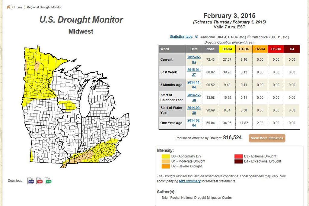
24 Example: Drought Conditions Source: National Drought Mitigation Center
25 Summary Develop target hydrology PS for specific wetland plant communities based on reference standard wetlands and best available information Use site-specific data to tailor target hydrology PS to achieve the objectives of a particular compensation site Match appropriate target hydrology with target vegetation Confirm whether PS are met using monitoring wells/dataloggers set for multiple readings/day Use 30-day rolling totals to characterize precipitation during each monitoring year Use best professional judgment and, when warranted, flexibility in applying the target hydrology PS Contact: Steve Eggers, Senior Ecologist, steve.d.eggers@usace.army.mil or /9/
d. Estimated potential indirect impacts to ombrotrophic bog communities due to proposed mine dewatering should not be rated as no effect.
 CEMVP-OP-R (MVP-1999-5528-JKA) 15 January 2015 MEMORANDUM SUBJECT: Response to Public Comments on Distinguishing Ombrotrophic and Somewhat Minerotrophic Bog Communities for Purposes of Estimating Potential
Guidelines for Conducting and Reporting Hydrologic Assessments of Potential Wetland Sites
 Wetlands Regulatory Assistance Program ERDC TN-WRAP-00-01 Guidelines for Conducting and Reporting Hydrologic Assessments of Potential Wetland Sites PURPOSE: This technical note provides guidance on performing
7.6 Wetlands, Riparian and Littoral Habitats
 7.6 Wetlands, Riparian and Littoral Habitats 7.6.1 Overview Yuba County Water Agency This section discusses wetland, riparian and littoral habitats in the vicinity 1 of Yuba County Water Agency s (YCWA
DEPARTMENT OF ENVIRONMENTAL PROTECTION Bureau of Water Quality Protection. Design Criteria - Wetlands Replacement/Monitoring
 DEPARTMENT OF ENVIRONMENTAL PROTECTION Bureau of Water Quality Protection DOCUMENT NUMBER: 363-0300-001 TITLE: Design Criteria - Wetlands Replacement/Monitoring EFFECTIVE DATE: February 11, 1997 AUTHORITY:
Municipal Stadium Wetland
 W A T E R S H E D F A C T S Total watershed area 140 mi 2 Average annual rainfall 38 in Average annual temperature 58 F Elevation Max 1321 ft Min 899 ft C. J. Brown Reservoir controls flow from 83 mi 2
CHAPTER FIVE Runoff. Engineering Hydrology (ECIV 4323) Instructors: Dr. Yunes Mogheir Dr. Ramadan Al Khatib. Overland flow interflow
 Instructors: Dr. Yunes Mogheir Dr. Ramadan Al Khatib. Overland flow interflow") Engineering Hydrology (ECIV 4323) CHAPTER FIVE Runoff Instructors: Dr. Yunes Mogheir Dr. Ramadan Al Khatib Overland flow interflow Base flow Saturated overland flow ١ ٢ 5.1 Introduction To Runoff Runoff
Engineering Hydrology (ECIV 4323) CHAPTER FIVE Runoff Instructors: Dr. Yunes Mogheir Dr. Ramadan Al Khatib Overland flow interflow Base flow Saturated overland flow ١ ٢ 5.1 Introduction To Runoff Runoff
WETLANDS AND OPEN WATERS Compensatory Mitigation Definitions of Factors
 Adverse effects as used in this section of the SOP means any adverse ecological effect on wetlands or areas of open water. Those effects, or impacts, include filling, excavating, flooding, draining, clearing,
Wetlands Project Guidance
 HABITAT Wetlands Project Guidance Stakeholder Informed Introduction Wetlands are lands saturated with water permanently or seasonally. Wetlands are typically defined by three characteristics: 1) The area
Water Table Monitoring Project Design
 Wetlands Regulatory Assistance Program ERDC TN-WRAP-06-2 Water Table Monitoring Project Design by Chris V. Noble PURPOSE: This document provides guidance for planning and implementing a wetland hydrology
HYDRIC SOILS. By Neal Svendsen Resource Soil Scientist Natural Resources Conservation Service Sept 2006
 HYDRIC SOILS By Neal Svendsen Resource Soil Scientist Natural Resources Conservation Service Sept 2006 Wetlands and Hydric Soils The term hydric soils proposed by Cowardin in 1979 Classification of Wetlands
An Explanation of the Hydric Soil Technical Standard and Normal Precipitation
 An Explanation of the Hydric Soil Technical Standard and Normal Precipitation From: National Technical Committee for Hydric Soils. 2001. Hydric Soil Technical Standard (Technical Note 11). http://soils.usda.gov/soil_us
G.B. Sonny Hall, PhD. Veronika Thiebach
 G.B. Sonny Hall, PhD Technical Program Manager Veronika Thiebach Senior Assistant General Counsel St. Johns River Water Management District 1 SJRWMD MFLs Method MFLs Method Premises Case studies Lake Hiawassee
Wetland and Stream Functional Assessment in North Carolina- A New Regulatory World?
 Wetland and Stream Functional Assessment in North Carolina- A New Regulatory World? John R. Dorney Moffatt & Nichol, Raleigh, NC September 14, 2015 North Carolina APWA Stormwater Conference, Wilmington,
PERFORMANCE STANDARDS AND MONITORING PROTOCOL FOR TIDAL WETLAND MITIGATION BANKS. October 28, 2016
 PERFORMANCE STANDARDS AND MONITORING PROTOCOL FOR TIDAL WETLAND MITIGATION BANKS October 28, 2016 A. Tidal wetland mitigation banks shall conform to the following performance standards by the end of the
Hydrology and Hydraulic Design Criteria for the Creation and Restoration of Wetlands
 WRP Technical Note HY-RS-3. 1 Hydrology and Hydraulic Design Criteria for the Creation and Restoration of Wetlands PURPOSE: Hydrology is generally accepted as the single most important factor governing
San Antonio Water System Mitchell Lake Constructed Wetlands Below the Dam Preliminary Hydrologic Analysis
 San Antonio Water System enhancement. This recommendation was based on limited water quality data provided by SAWS and using a free-water surface constructed wetland with approximately 112 acres of wetted
Wetlands in Alberta: Challenges and Opportunities. David Locky, PhD, PWS, PBiol Grant MacEwan University
 Wetlands in Alberta: Challenges and Opportunities David Locky, PhD, PWS, PBiol Grant MacEwan University Overview What & Where Function & Value Alberta s Keystone Ecosystem Losses & Impacts Restoration
Public Notice ISSUED: June 29, 2017 EXPIRES: July 31, 2017
 SPONSOR: Gary Pestorious Public Notice ISSUED: June 29, 2017 EXPIRES: July 31, 2017 REFER TO: 2012-01634-DAS SECTION:404 - Clean Water Act 1. WETLAND COMPENSATORY MITIGATION BANK PROPOSAL: Pickerel Lake
VIDEO: Freshwater Wetlands
 VIDEO: Freshwater Wetlands Adapted from: Freshwater Wetlands-Life at the Waterworks. Educational Media Corporation / North Carolina State Museum of Natural Sciences. Introduction to Wetlands Grade Level:
PART I: ASSESSMENT OF WETLAND HYDROLOGY AT RESTORATION SITES PART II: CLIMATE CHANGE IMPACTS ON WETLAND HYDROLOGY BOUNDARIES. Mike Vepraskas NC State
 PART I: ASSESSMENT OF WETLAND HYDROLOGY AT RESTORATION SITES PART II: CLIMATE CHANGE IMPACTS ON WETLAND HYDROLOGY BOUNDARIES Mike Vepraskas NC State Do these sites have wetland hydrology? Restored and
POLICY FOR NATURAL RESOURCE MANAGEMENT AREAS
 POLICY FOR NATURAL RESOURCE MANAGEMENT AREAS I. POLICY STATEMENT Auburn University's (the University's) "Policy for Natural Resource Management Areas" implements the Campus Master Plan Land Use Element
Manitoba s Submission Guidelines for Peatland Management Plans
 Manitoba s Submission Guidelines for Peatland Management Plans Peatland Management Guidebook Forestry and Peatlands Branch Manitoba Sustainable Development First Published: September 2017 Review by: 2022
Biogeochemistry of Wetlands: Wetland hydrology
 Institute of Food and Agricultural Sciences (IFAS) Wetland hydrology, transport processes, and modeling June 23-26, 2008 Gainesville, Florida Wetland Biogeochemistry Laboratory Soil and Water Science Department
Information for File # PRH
 Information for File # 2016-02602-PRH Applicant Corps Contact Tom Morley Paul Hauser Address 152 Baker Drive, Redwood Falls, MN 56283 E-Mail Paul.R.Hauser@usace.army.mil Phone 651-290-5357 Primary County
Public Notice ISSUED: August 11, 2015 EXPIRES: September 10, 2015
 APPLICANT: John Deer Horicon Works Public Notice ISSUED: August 11, 2015 EXPIRES: September 10, 2015 REFER TO: MVP-2015-02020-JVD SECTION: 404 - Clean Water Act 1. APPLICATION FOR PERMIT TO discharge fill
Nantahala Pisgah NF Plan Process - Natural Range of Variation. Gary Kauffman National Forests in NC Ecologist
 Nantahala Pisgah NF Plan Process - Natural Range of Variation Gary Kauffman National Forests in NC Ecologist 1 NRV Plan Directives indicate must contain plan components, including standards or guidelines,
Department of the Army Permit Application
 Department of the Army Permit Application DA File Number U.S. Army Corps of Engineers Honolulu District Date Received by CEPOH-RO Send Completed Application to: Honolulu District, U.S. Army Corps of Engineers
NJDEP Regulations that impact or soon will impact agricultural operations. April 1, 2007 Horses 2007
 NJDEP Regulations that impact or soon will impact agricultural operations. April 1, 2007 Horses 2007 Peter L. Kallin, Ph.D., P.W.S. Phone: 732-499-3600 Ext. 237 E-mail: pkallin@aesop.rutgers.edu www.water.rutgers.edu
Wetland Animals. Grade Level: Basic or intermediate. Duration: 30 minutes 1 hour. Setting: Classroom
 Wetland Animals Wetland Animals Adapted from: Wetland Address in WOW! Wonders of Wetlands: An Educator s Guide. Bozeman: The Watercourse and Environmental Concern, Inc., 1995. Grade Level: Basic or intermediate
NEW CASTLE CONSERVATION DISTRICT. through. (Name of Municipality) PLAN REVIEW APPLICATION DRAINAGE, STORMWATER MANAGEMENT, EROSION & SEDIMENT CONTROL
 PLAN REVIEW APPLICATION DRAINAGE, STORMWATER MANAGEMENT, EROSION & SEDIMENT CONTROL") NEW CASTLE CONSERVATION DISTRICT through (Name of Municipality) PLAN REVIEW APPLICATION DRAINAGE, STORMWATER MANAGEMENT, EROSION & SEDIMENT CONTROL Office use only: Received by Municipality: Received by
NEW CASTLE CONSERVATION DISTRICT through (Name of Municipality) PLAN REVIEW APPLICATION DRAINAGE, STORMWATER MANAGEMENT, EROSION & SEDIMENT CONTROL Office use only: Received by Municipality: Received by
Pennsylvania Stormwater Best Management Practices Manual. Chapter 3. Stormwater Management Principles and Recommended Control Guidelines
 Pennsylvania Stormwater Best Management Practices Manual Chapter 3 Stormwater Management Principles and Recommended Control Guidelines 363-0300-002 / December 30, 2006 Chapter 3 Stormwater Management Principles
BIOMES. Living World
 BIOMES Living World Biomes Biomes are large regions of the world with distinctive climate, wildlife and vegetation. They are divided by terrestrial (land) or aquatic biomes. Terrestrial Biomes Terrestrial
SW-74 SERENOVA PRESERVE SITES 2, 3, 4, 8 MITIGATION PLAN
 SW-74 SERENOVA PRESERVE SITES 2, 3, 4, 8 MITIGATION PLAN BACKGROUND INFORMATION Project SWIM? Aquatic Control? Exotic Control? Mitigation Bank? Type No No No No Mitigation Restoration and enhancement Type
Application of a Basin Scale Hydrological Model for Characterizing flow and Drought Trend
 Application of a Basin Scale Hydrological Model for Characterizing flow and Drought Trend 20 July 2012 International SWAT conference, Delhi INDIA TIPAPORN HOMDEE 1 Ph.D candidate Prof. KOBKIAT PONGPUT
Surface Water and Non-Wetland Surface Waters Delineation and Classification pursuant Chapter F.A.C.
 Surface Water and Non-Wetland Surface Waters Delineation and Classification pursuant Chapter 62-340 F.A.C. What are Waters? 373.019 F.S. Definitions (20) Water or waters in the state means any and all
Climate: describes the average condition, including temperature and precipitation, over long periods in a given area
 Ch. 6 - Biomes Section 6.1: Defining Biomes Biome: a group of ecosystems that share similar biotic and abiotic conditions, large region characterized by a specific type of climate, plants, and animals
M.L. Kavvas, Z. Q. Chen, M. Anderson, L. Liang, N. Ohara Hydrologic Research Laboratory, Civil and Environmental Engineering, UC Davis
 Assessment of the Restoration Activities on Water Balance and Water Quality at Last Chance Creek Watershed Using Watershed Environmental Hydrology (WEHY) Model M.L. Kavvas, Z. Q. Chen, M. Anderson, L.
John H. Kerr Dam and Reservoir Virginia and North Carolina (Section 216)
") John H. Kerr Dam and Reservoir Virginia and North Carolina (Section 216) Wilmington District, Corps of Engineers Stakeholder Update Presentation January 24, 2014 Authorized under Section 216 of Public
John H. Kerr Dam and Reservoir Virginia and North Carolina (Section 216) Wilmington District, Corps of Engineers Stakeholder Update Presentation January 24, 2014 Authorized under Section 216 of Public
COMPENSATORY MITIGATION AND THE MITIGATION RULE. USACE, Jacksonville District
 COMPENSATORY MITIGATION AND THE MITIGATION RULE USACE, Jacksonville District US US Army Army Corps Corps of of Engineers Engineers BUILDING BUILDING STRONG STRONG What is Mitigation? Sequential process
Feasibility Report with Integrated Environmental Assessment Rip Rap Landing HREP APPENDIX M MONITORING & ADAPTIVE MANAGEMENT PLAN
 Feasibility Report with Integrated Environmental Assessment APPENDIX M MONITORING & ADAPTIVE MANAGEMENT PLAN Feasibility Report with Integrated Environmental Assessment INTENTIONALLY LEFT BLANK Feasiblity
Hubbard Lake State Game Area Master Plan
 Hubbard Lake State Game Area Master Plan MICHIGAN DEPARTMENT OF NATURAL RESOURCES WILDLIFE DIVISION BRIAN PICCOLO AUGUST 2017 Intended Purpose and General Management Direction Hubbard Lake State Game Area
Constructed Wetland Use in Nonpoint Source Control
 Constructed Wetland Use in Nonpoint Source Control Description Constructed wetlands are excavated basins with irregular perimeters and undulating bottom contours into which wetland vegetation is purposely
Examples of Performance Standards for Wetland Creation and Restoration in Section 404 Permits and an Approach to Developing Performance Standards
 Examples of Performance Standards for Wetland Creation and Restoration in Section 404 Permits and an Approach to Developing Performance Standards PURPOSE: This technical note accomplishes the following:
I THOUGHT IT WAS JUST WET LAND: A GUIDE TO ENVIRONMENTAL PERMITTING FOR AIRPORTS ROAD SCHOOL 2018 SIMON DAVIES, SENIOR SCIENTIST MARCH 7, 2018
 I THOUGHT IT WAS JUST WET LAND: A GUIDE TO ENVIRONMENTAL PERMITTING FOR AIRPORTS ROAD SCHOOL 2018 SIMON DAVIES, SENIOR SCIENTIST MARCH 7, 2018 Definition Regulatory Definition - Those areas that are inundated
Prepared by: Rummel, Klepper & Kahl
 WETLAND DELINEATION REPORT Kutztown Road (SR 1033) Resurfacing and Bridge Replacement Upper Hanover Township, Montgomery County, Pennsylvania Prepared for: PennDOT District 6-0 Prepared by: Rummel, Klepper
Wetland Restoration in Alberta
 Wetland Restoration in Alberta Thorsten Hebben, MSc., PBiol. Limnologist and Policy Analyst Policy Division Alberta Environment & Sustainable Resource Development Outline Mechanisms Legislative Authority
Chapter 10 Natural Environment
 Chapter 10 Natural Environment Existing Conditions The Natural Environment Element addresses the protection, conservation, preservation, and restoration of the natural resources the Bayview Ridge Subarea,
Montana Ground-Water Assessment Statewide Monitoring Well Network
 Montana Ground-Water Assessment Statewide Monitoring Well Network Montana Ground-Water Assessment Water-level Monitoring and Drought: January - March 2003 Tom Patton - Montana Bureau of Mines and Geology
6.0 Runoff. 6.1 Introduction. 6.2 Flood Control Design Runoff
 October 2003, Revised February 2005 Chapter 6.0, Runoff Page 1 6.1 Introduction 6.0 Runoff The timing, peak rates of discharge, and volume of stormwater runoff are the primary considerations in the design
Vegetation Management and Water Yield: Silver Bullet or a Pipe Dream?
 Vegetation Management and Water Yield: Silver Bullet or a Pipe Dream? Lee H. MacDonald rofessor Emeritus and Senior Research Scientist Watershed Science/NREL Colorado State University, Fort Collins, CO
Alberta Transportation s Wetland Habitat Compensation Program
 Alberta Transportation s Wetland Habitat Compensation Program Water Technologies Symposium 2014 Mark Svenson, P.Biol Provincial Transportation Environmental Coordinator Alberta Transportation Outline Wetland
Chapter 13: Wildlife and Vegetation
 Chapter 13: Wildlife and Vegetation Introduction and Setting Nevada County contains an extremely wide range of plants, animals and habitat types. With topographic elevations ranging from 300 feet in the
COMFORT LAKE - FOREST LAKE WATERSHED DISTRICT RULES. Adopted December 18, 2008 Amended March, 24, 2011
 COMFORT LAKE - FOREST LAKE WATERSHED DISTRICT RULES Adopted December 18, 2008 Amended March, 24, 2011 INTRODUCTION... 2 DEFINITIONS... 3 1.0 PROCEDURAL REQUIREMENTS... 8 2.0 STORMWATER MANAGEMENT... 10
New Castle County, DE. Floodplain Regulations
 New Castle County, DE Floodplain Regulations John J. Gysling, PE CFM Department of Land Use New Castle County, DE February 26, 2009 Today s Presentation Floodplain Protection and Uses Terms and Definitions
The History and Use of Field Indicators of Hydric Soils in the United States
 The History and Use of Field Indicators of Hydric Soils in the United States Lenore Matula Vasilas Soil Scientist USDA NRCS Beltsville, MD 1970s Soil Taxonomy incorporates wet soils into the classification
Kevin L. Erwin CE PWS Kevin L. Erwin Consulting Ecologist, Inc Bayside Parkway Ft. Myers, Florida USA
 Kevin L. Erwin CE PWS Kevin L. Erwin Consulting Ecologist, Inc. 2077 Bayside Parkway Ft. Myers, Florida 33901 USA The Lee County DR/GR: Implications for future restoration and management Estero Bay Watershed
U.S. Army Corps of Engineers Permit Application Tips
 U.S. Army Corps of Engineers Permit Application Tips MnDOT Environmental Conference Ben Orne and Sarah Wingert, USACE 4-29-2015 US Army Corps of Engineers BUILDING STRONG Outline Introduction to Corps
Adapting Watershed Tools to Protect Wetlands
 W E T L A N D S & W A T E R S H E D S Adapting Watershed Tools to Protect Wetlands DECEMBER 2005 3 Adapting Watershed Tools to Protect Wetlands Wetlands & Watersheds Article #3 Prepared by: Karen Cappiella,
RAPID ASSESSMENT OF WETLAND FUNCTIONAL VALUES FOR THE WAUKESHA WEST BYPASS ALTERNATIVE ROUTES
 RAPID ASSESSMENT OF WETLAND FUNCTIONAL VALUES FOR THE WAUKESHA WEST BYPASS ALTERNATIVE ROUTES S O U T H E A S T E R N W I S C O N S I N R E G I O N A L P L A N N I N G C O M M I S S I O N TABLE OF CONTENTS
Intermittent Stream Reclamation
 Reclamation About Mosaic Reclamation > In carrying out its mission to help the world grow the food it needs, Mosaic couples recovery of phosphate resources with respect of the phosphate-rich land that
Water and Watersheds. Data Maps Action
 Water and Watersheds Data Maps Action What is the Wildlife Action Plan? Restore rare wildlife and habitats. Keep common species common. 2015 Revision: Partners in Conservation Science 2015 Revision Data
M E M O R A N D U M Clallam County Public Works Department
 M E M O R A N D U M Clallam County Public Works Department TO: TO: Craig Jacobs, Public Works Director Joel Winborn, Division Manager FROM: Dave Lasorsa, Environmental Coordinator SUBJ: Wetland Assessment
Public Notice ISSUED: 26 December 2017 EXPIRES: 26 January 2018
 SPONSOR: Carex Group, LLC Public Notice ISSUED: 26 December 2017 EXPIRES: 26 January 2018 REFER TO: MVP-2015-01348-EJI SECTION:404 - Clean Water Act 1 WETLAND COMPENSATORY MITIGATION BANK PROPOSAL 2 SPECIFIC
Lower Columbia River Pile Dike Assessment
 Lower Columbia River Pile Dike Assessment David Gorman, PE August 2, 2011 Credits Hans R. Moritz, US Army Corps of Engineers Portland District Carl Kassebaum, AECOM Project Manager AECOM Coastal and Rivers
Uncertainty in Hydrologic Modelling for PMF Estimation
 Uncertainty in Hydrologic Modelling for PMF Estimation Introduction Estimation of the Probable Maximum Flood (PMF) has become a core component of the hydrotechnical design of dam structures 1. There is
PIMA COUNTY COMPREHENSIVE PLAN CO PIMA COUNTY REGIONAL COMPREHENSIVE PLAN POLICY MAJOR PLAN AMENDMENT
 PIMA COUNTY COMPREHENSIVE PLAN CO7-07-04 PIMA COUNTY REGIONAL COMPREHENSIVE PLAN POLICY MAJOR PLAN AMENDMENT Arizona law [A.R.S. 11-821(C)(3)] requires: Planning for water resources that addresses: a)
Dane County Wetlands Resource Management Guide
 Dane County Wetlands Resource Management Guide May 2008 Dane County Wetlands Resource Management Guide Capital Area Regional Planning Commission: Project Staff: Kamran Mesbah, Deputy Director and Director,
Doyle Park Reconstruction Project Improving Flood Control Facilities to Meet a TMDL
 Doyle Park Reconstruction Project Improving Flood Control Facilities to Meet a TMDL Ann Arbor, Michigan Washtenaw County Drain Commissioner & Malletts Creek Coordinating Committee November, 2007 Janis
Recent Developments in Water Withdrawal Management
 Recent Developments in Water Withdrawal Management Frank Ruswick David A. Hamilton Michigan Department of Environmental Quality Overview What Water Withdrawals are regulated? Water Withdrawal Assessment
Interest in a Community Model for Operational Delta Forecasting
 NOAA s National Weather Service California-Nevada River Forecast Center Interest in a Community Model for Operational Delta Forecasting Rob Hartman Hydrologist in Charge Mission of NWS Hydrologic Services
7.0 natural resources. 178 Natural Resources
 7.0 natural resources 178 Natural Resources 7.0 Natural Resources 7.1 Natural Areas and Agricultural Features Sibley County is rich in vast areas of cropland and steeped in the agricultural industry. While
Hydrologic Analysis Techniques ( 87 Manual Hydrology Tools )
") Hydrologic Analysis Techniques ( 87 Manual Hydrology Tools ) Objectives Know which wetland applies to which technique Define the Wetland Water Budget Locate data Understand the time step Understand Limitations
Hydrologic Analysis Techniques ( 87 Manual Hydrology Tools ) Objectives Know which wetland applies to which technique Define the Wetland Water Budget Locate data Understand the time step Understand Limitations
Calculating Mitigation
 US Army Corps of Engineers Jacksonville District Calculating Mitigation Lift Loss 1 US Army Corps of Engineers Jacksonville District Under the U.S. Army Corps of Engineers Regulatory Program, mitigation
1. GENERAL DESCRIPTION OF LAND USE / COVER TYPES (SEE GENERAL DESCRIPTIONS ON PAGE 7) A 2. ADJACENT LANDS & EASEMENTS 3. FAMILY AGRICULTURAL LEGACY
 A 2. ADJACENT LANDS & EASEMENTS 3. FAMILY AGRICULTURAL LEGACY") CONSERVATION EASEMENT PROJECT: COUNTY: NAME OF LANDOWNER: CELL/OFFICE PHONE: NAME OF FARM / SITE MANAGER: CELL/OFFICE PHONE: GENERAL DESCRIPTION OF LAND USE / COVER TYPES (SEE GENERAL DESCRIPTIONS ON PAGE
CONSERVATION EASEMENT PROJECT: COUNTY: NAME OF LANDOWNER: CELL/OFFICE PHONE: NAME OF FARM / SITE MANAGER: CELL/OFFICE PHONE: GENERAL DESCRIPTION OF LAND USE / COVER TYPES (SEE GENERAL DESCRIPTIONS ON PAGE
Rural Wetland Functions and Protection: A Case Study. by Doug Littauer
 Rural Wetland Functions and Protection: A Case Study by Doug Littauer A Thesis Submitted in partial fulfillment of the requirements for the degree Master of Environmental Studies The Evergreen State College
Stormwater Local Design Manual For Houston County, Georgia
 Stormwater Local Design Manual For Houston County, Georgia Adopted November 15, 2005 TABLE OF CONTENTS 1. FORWARD... 1 2. GENERAL LEVEL OF SERVICE STANDARDS... 2 2.1. DETENTION REQUIREMENTS... 2 2.1.1.
The Sustainability of Floods Pond
 The Sustainability of Floods Pond Bangor Water District s Public Water Supply Presented By: Rick Pershken Bangor Water District Overview Brief BWD History Watershed Characteristics Lake Characteristics
Freight Street Development Strategy
 Freight Street Development Strategy Appendix B: Naugatuck River Floodplain Analysis Freight Street Development Strategy DECEMBER 2017 Page B-1 1.0 NAUGATUCK RIVER FLOODPLAIN AT FREIGHT STREET 1.1 Watershed
Section 4. Terrestrial Habitats
 Section 4. Terrestrial Habitats Components of Reports... 1226 Definition ranking Key factors Indicators of condition Conservation actions Monitoring Terrestrial Habitat Reports... 1231 Caves, Mines, Sinkholes,
Spring Forecast Based Operations, Folsom Dam, California
 Spring Forecast Based Operations, Folsom Dam, California Paul E. Pugner, P.E. Chief, Water Management Section Sacramento District U.S. Army 1325 J Street, Room 1126 Sacramento, CA 95814-2922 Tel: (916)
Constructed Wetland Pond T-8
 Constructed Wetland Pond T-8 Description A constructed wetlands pond is a shallow retention pond designed to permit the growth of wetland plants such as rushes, willows, and cattails. Constructed wetlands
MODEL Stormwater Local Design Manual. City of Centerville
 MODEL Stormwater Local Design Manual City of Centerville Adopted December 6, 2005 TABLE OF CONTENTS 1. FORWARD... 1 2. GENERAL LEVEL OF SERVICE STANDARDS... 1 2.1. DETENTION REQUIREMENTS... 1 2.1.1. Discharge
Irrigating Efficiently: tools, tips & techniques. Steve Castagnoli, OSU Extension Service
 Irrigating Efficiently: tools, tips & techniques Steve Castagnoli, OSU Extension Service Tonight s class: Why plants need water When plants need water How much water plants need Soil as a reservoir of
Information for File #MVP MVM
 Information for File #MVP-2015-04077-MVM Applicant: Preferred Properties and Management, LLC Corps Contact: Marissa Merriman Address: 180 Fifth Street East, Suite 700, St. Paul, Minnesota 55101-1678 E-Mail:
Climate Change Vulnerability Assessment of Natural Features in Michigan s Coastal Zone Phase I: Potential Changes to Natural Communities
 Climate Change Vulnerability Assessment of Natural Features in Michigan s Coastal Zone Phase I: Potential Changes to Natural Communities Prepared by: Michael A. Kost and Yu Man Lee Michigan Natural Features
US Army Corps of Engineers and Stream Restoration Permitting
 US Army Corps of Engineers and Stream Restoration Permitting Jack Dinne US Army Corps of Engineers-Baltimore Maryland Section Northern May 6, 2014 US Army Corps of Engineers Presentation Overview Corps
 Good Morning! Bruce Gilman Department of Environmental Conservation and Horticulture Finger Lakes Community College 3325 Marvin Sands Drive Canandaigua, New York 14424 585-785- 1255 gilmanba@flcc.edu Northern
Once There Were Beavers: A Stream Flow Restoration Project for the Potomac Headwaters. Cacapon Institute High View, WV
 Once There Were Beavers: A Stream Flow Restoration Project for the Potomac Headwaters Cacapon Institute High View, WV Technical Committee: John Schmidt (USFWS), Ed Kesecker (USDA-NRCS), Pam Edwards (USDA-
Great Lakes Update. Volume 189: 2013 January through June Summary
 Great Lakes Update Volume 189: 2013 January through June Summary The U.S. Army Corps of Engineers (USACE) tracks the water levels of each of the Great Lakes. This report highlights hydrologic conditions
Overview of Corps Regulatory Program
 Overview of Corps Regulatory Program Lee Anne Devine Chief, Regulatory Branch Louisville District US Army Corps of Engineers Regulatory Program Corps Authority (Laws) Waters Applying for a Permit Types
THE WATER IS RISING SCALABLE, RELIABLE, AND RELEVANT INFORMATION SUPPORTING FIRST RESPONDERS. May 3, 2017
 THE WATER IS RISING SCALABLE, RELIABLE, AND RELEVANT INFORMATION SUPPORTING FIRST RESPONDERS May 3, 2017 Association of State Floodplain Managers 2017 Conference Jim Keith, PE, CFM Walter P Moore Andy
EFFECTS OF WATERSHED TOPOGRAPHY, SOILS, LAND USE, AND CLIMATE ON BASEFLOW HYDROLOGY IN HUMID REGIONS: A REVIEW
 PROGRESS IN PHYSICAL GEOGRAPHY EFFECTS OF WATERSHED TOPOGRAPHY, SOILS, LAND USE, AND CLIMATE ON BASEFLOW HYDROLOGY IN HUMID REGIONS: A REVIEW KATIE PRICE 2011 Presented by: Jordan Martin Article Overview
12/9/2011. Constructed Wetlands. Functions, Design Criteria
 Constructed Wetlands Functions, Design Criteria 1 2 Functions of Wetlands Flood mitigation Water filtration/purification (treatment) Wildlife habitat, biodiversity Biogeochemical cycles Recreation Reasons
REROUTING DRAINAGE SYSTEMS
 MINNESOTA WETLAND RESTORATION GUIDE REROUTING DRAINAGE SYSTEMS TECHNICAL GUIDANCE DOCUMENT Document No.: WRG 4A-4 Publication Date: 10/14/2015 Table of Contents Introduction Application Design Considerations
Simulation of Event Based Runoff Using HEC-HMS Model for an Experimental Watershed
 International Journal of Hydraulic Engineering 213, 2(2): 28-33 DOI: 1.5923/j.ijhe.21322.2 Simulation of Event Based Runoff Using HEC-HMS Model for an Experimental Watershed Reshma T *, Venkata Reddy K,
3 Objectives 3 Ob jec tives
 3 Objectives 3 Objectives 3 Objectives 3 Objectives contents Objective number Page 3.1 Ki uta ki tai: mountains to the sea O1-O5 37 3.2 Beneficial use and development O6-O13 38 3.3 Māori relationships
Climate Change Impacts in Washington State
 Climate Change Impacts in Washington State Lara Whitely Binder Climate Impacts Group College of the Environment University of Washington Evergreen College January 13, 2016 Climate Science in the Public
EVALUATION OF HYDROLOGIC AND WATER RESOURCES RESPONSE TO METEOROLOGICAL DROUGHT IN THESSALY, GREECE
 EVALUATION OF HYDROLOGIC AND WATER RESOURCES RESPONSE TO METEOROLOGICAL DROUGHT IN THESSALY, GREECE A. LOUKAS*, AND L. VASILIADES Laboratory of Hydrology and Water Systems Analysis,, Volos, Greece *E-mail:
Definitions 3/16/2010. GG22A: GEOSPHERE & HYDROSPHERE Hydrology
 GG22A: GEOSPHERE & HYDROSPHERE Hydrology Definitions Streamflow volume of water in a river passing a defined point over a specific time period = VxA discharge m 3 s -1 Runoff excess precipitation - precipitation