SAN BERNARD RIVER WATER QUALITY MODEL UPDATE. August 18, 2011
|
|
|
- Alvin Hoover
- 6 years ago
- Views:
Transcription

1 SAN BERNARD RIVER WATER QUALITY MODEL UPDATE August 18, 2011
2 Agenda Model Set-up Watershed model Watershed delineations Generate model input files & establish coefficients Receiving Water model Establish boundary conditions Segmentation based on tidal conditions and stream volumes Develop model and establish coefficients Data gathering Next Steps
3 Agenda Model Set-up Watershed model Watershed delineations Generate model input files & establish coefficients Receiving Water model Establish boundary conditions Segmentation based on tidal conditions and stream volumes Develop model and establish coefficients Data gathering Next Steps
4 Watershed delineation: input data Necessary to delineate watersheds to take into account: Calibration stations Point sources Tidal boundary Tributary confluence with main steam of river Predominant watershed characteristics Data sources Digital Elevation Model (DEM) Stream Network Shapefile Land Use/Land Cover Data Layer Soil Data Layer

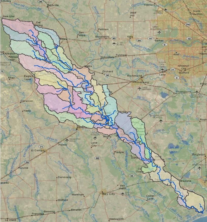

5 Delineated subbasins
6 Watershed Model Generate model input files Input files are being developed Model input file requires: Land use/land cover information Watershed practices Soils information Information about bacteria sources in the watershed to establish land practices and model coefficients
7 Agenda Model Set-up Watershed model Watershed delineations Generate model input files & establish coefficients Receiving Water model Establish boundary conditions Segmentation based on tidal conditions and stream volumes Develop model and establish coefficients Data gathering Next Steps

8 Tidal Prism Boundary Conditions Upper boundary established at State Highway 35 salt water barrier dam

9 Tidal Prism Boundary Conditions Lower boundary established at upstream side of intercoastal water way
10 Receiving Water Model Develop model Model being developed Model requires: Stream invert elevations Input from upstream and watershed runoff from watershed model Information about in-stream bacteria sources to establish loading and model coefficients
11 Agenda Model Set-up Watershed model Watershed delineations Generate model input files & establish coefficients Receiving Water model Establish boundary conditions Segmentation based on tidal conditions and stream volumes Develop model and establish coefficients Data gathering Next Steps
12 Data Gathering Weather data Rainfall Temperature Solar radiation Relative Humidity Wind speed Water quality data Bacteria Salinity Flow data
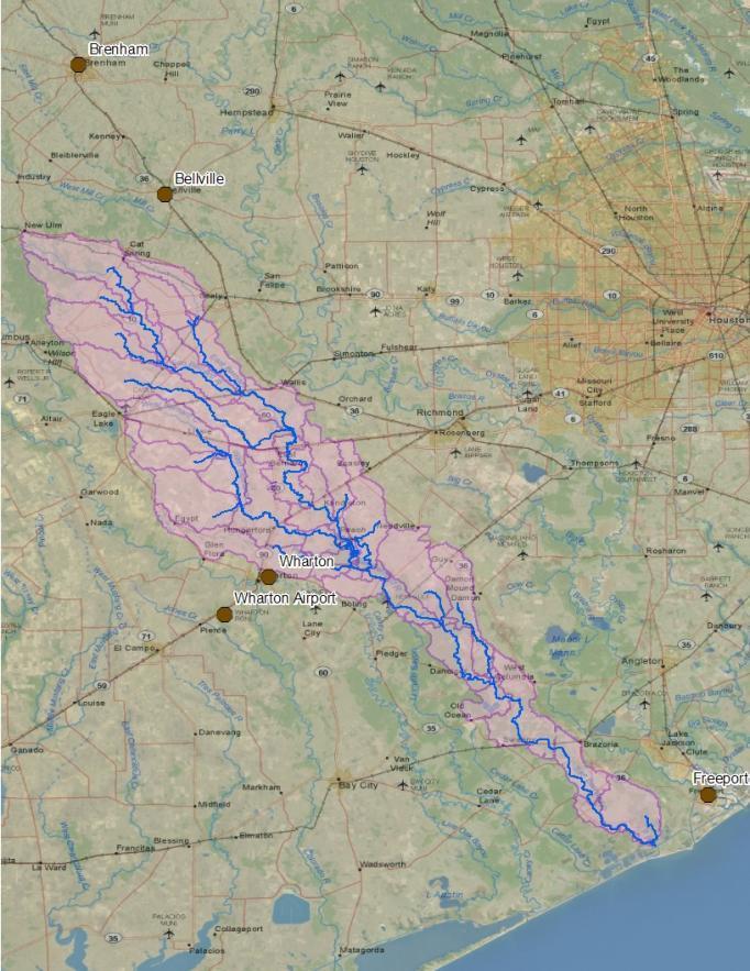
13 Precipitation Stations
14 Overall Simulation and Calibration/Validation Period Selection Rainfall Data Stations ID # Records Period of Record Bellville 1189 Jan June 2011 Freeport 1086 Jan June 2011 Wharton 1548 Jan June 2011 Brenham 818 June July 2011 LCRA 1026 Jan May 2011 Rainfall and weather data available from January 2000 through May 2011
15 Calibration Stations - Flow
16 Calibration and Validation Period Selection Stations ID # Records Period of Record USGS 3891 Jan Sept LCRA 4141 Jan May 2011 Flow data available through January 2000 through September 2010

17 Calibration Stations Water quality
18 Daily Flow (cfs) USGS Daily Flow Data
19 Daily Flow (cfs) LCRA Daily Flow Data
20 Overall Simulation and Calibration/Validation Period Selection Water Quality Data Stations ID # Records Period of Record Oct March Jan Oct Jan Aug Oct Aug Dec July Jan Aug Feb Aug Feb Aug April Oct Oct Oct Majority of bacteria data available from January 2001 through July 2010


21 E. Coli (MPN/100 ml) E. coli vs. Time, Upper Region Station Non-Tidal Station ID: Date
 Enterococci vs.")


22 E. Coli (MPN/100 ml) Enterococci vs. Time, Lower Region Station Tidal Station ID: Date
23 Calibration and Validation Period Selection criteria: Majority of data are available January 2001 through July 2010 Flow data available beginning in January 2000 Model simulation period: January 1 st, 2000 to September 30 th, 2010 Calibration Period: January 1 st, 2001 to December 31 st, 2003 Validation Period: January 1 st, 2006 to December 31 st, 2009
24 Agenda Model Set-up Watershed model Watershed delineations Generate model input files & establish coefficients Receiving Water model Establish boundary conditions Segmentation based on tidal conditions and stream volumes Develop model and establish coefficients Data gathering Next Steps
25 Next steps Watershed model Complete model set-up Calibrate/validate BMP evaluation Tidal prism Complete model development Calibrate/validate Test BMP evaluation scenarios from the watershed model
Rock Creek Floodplain Analysis
 Rock Creek Floodplain Analysis www.co.washington.or.us By Jon Franczyk 1996 Flood, www.co.washington.or.us 1996 Flood, www.co.washington.or.us Project Outline Project Goals Introduction Background Study
The Impacts of Climate Change on Portland s Water Supply
 The Impacts of Climate Change on Portland s Water Supply Richard Palmer and Margaret Hahn University of Washington Department of Civil and Environmental Engineering Joe Dvorak, Dennis Kessler, Azad Mohammadi
Utilization of the SWAT Model and Remote Sensing to Demonstrate the Effects of Shrub Encroachment on a Small Watershed
 Utilization of the SWAT Model and Remote Sensing to Demonstrate the Effects of Shrub Encroachment on a Small Watershed Jason Afinowicz Department of Biological and Agricultural Engineering Texas A&M University
The Fourth Assessment of the Intergovernmental
 Hydrologic Characterization of the Koshi Basin and the Impact of Climate Change Luna Bharati, Pabitra Gurung and Priyantha Jayakody Luna Bharati Pabitra Gurung Priyantha Jayakody Abstract: Assessment of
IMPACT OF CLIMATE CHANGE ON WATER AVAILABILITY AND EXTREME FLOWS IN ADDIS ABABA
 IMPACT OF CLIMATE CHANGE ON WATER AVAILABILITY AND EXTREME FLOWS IN ADDIS ABABA Contents Background of climate change Climate Change Studies in and Around Addis Ababa Impact of climate change on Water
Overview of the Surface Hydrology of Hawai i Watersheds. Ali Fares Associate Professor of Hydrology NREM-CTAHR
 Overview of the Surface Hydrology of Hawai i Watersheds Ali Fares Associate Professor of Hydrology NREM-CTAHR 5/23/2008 Watershed Hydrology Lab 1 What is Hydrology? Hydrology is the water science that
Chehalis Basin Strategy Causes of Extreme Flooding. October 11, 2016 Policy Workshop
 Chehalis Basin Strategy Causes of Extreme Flooding October 11, 2016 Policy Workshop Agenda Hydrology o Precipitation o Flow Climate Change Effects Land Use o Channel straightening and incision o Riparian
San Antonio Water System Mitchell Lake Constructed Wetlands Below the Dam Preliminary Hydrologic Analysis
 San Antonio Water System enhancement. This recommendation was based on limited water quality data provided by SAWS and using a free-water surface constructed wetland with approximately 112 acres of wetted
M.L. Kavvas, Z. Q. Chen, M. Anderson, L. Liang, N. Ohara Hydrologic Research Laboratory, Civil and Environmental Engineering, UC Davis
 Assessment of the Restoration Activities on Water Balance and Water Quality at Last Chance Creek Watershed Using Watershed Environmental Hydrology (WEHY) Model M.L. Kavvas, Z. Q. Chen, M. Anderson, L.
RIO GRANDE HEADWATERS RESPONSE TO CLIMATE AND FOREST CHANGE
 RIO GRANDE HEADWATERS RESPONSE TO CLIMATE AND FOREST CHANGE Melissa Valentin, PE, PhD Student and Terri Hogue, PhD, Professor Department of Civil and Environmental Engineering Colorado School of Mines,
Mekong Climate Change and Adaptation Initiative of the Mekong River Commission
 Mekong Climate Change and Adaptation Initiative of the Mekong River Commission H. E. Mr. Kol Vathana Mekong River Commission; Deputy Secretary General Cambodia National Mekong Committee Mekong is one of
Application of a Basin Scale Hydrological Model for Characterizing flow and Drought Trend
 Application of a Basin Scale Hydrological Model for Characterizing flow and Drought Trend 20 July 2012 International SWAT conference, Delhi INDIA TIPAPORN HOMDEE 1 Ph.D candidate Prof. KOBKIAT PONGPUT
REGIONAL STORMWATER CAPTURE & USE FEASIBILITY STUDY TAC MEETING #1 - JULY 18, 2017
 REGIONAL STORMWATER CAPTURE & USE FEASIBILITY STUDY TAC MEETING #1 - JULY 18, 2017 Agenda 1. Welcome & Introductions Project Team Technical Advisory Committee (TAC) 2. Study Overview 3. TAC Charter 4.
2
 1 2 3 4 5 6 The program is designed for surface water hydrology simulation. It includes components for representing precipitation, evaporation, and snowmelt; the atmospheric conditions over a watershed.
CHAPTER FIVE Runoff. Engineering Hydrology (ECIV 4323) Instructors: Dr. Yunes Mogheir Dr. Ramadan Al Khatib. Overland flow interflow
 Instructors: Dr. Yunes Mogheir Dr. Ramadan Al Khatib. Overland flow interflow") Engineering Hydrology (ECIV 4323) CHAPTER FIVE Runoff Instructors: Dr. Yunes Mogheir Dr. Ramadan Al Khatib Overland flow interflow Base flow Saturated overland flow ١ ٢ 5.1 Introduction To Runoff Runoff
Engineering Hydrology (ECIV 4323) CHAPTER FIVE Runoff Instructors: Dr. Yunes Mogheir Dr. Ramadan Al Khatib Overland flow interflow Base flow Saturated overland flow ١ ٢ 5.1 Introduction To Runoff Runoff
The Confluence Model. Presentation to Modeling and Forecasting Working Group January 21, 2015
 The Confluence Model Presentation to Modeling and Forecasting Working Group January 21, 2015 Introductions Presenter: Gary Fiske Working Group Water Department staff Objective: Penetrate the Black Box
Water Operations 101. Jerry Johns and John Leahigh Department of Water Resources BDCP Steering Committee 5/8/09
 Water Operations 101 Jerry Johns and John Leahigh Department of Water Resources BDCP Steering Committee 5/8/09 Water Operations Overview Where Does BDCP Fit Into California Planning Hydrologic Variability
Estimation of Actual Evapotranspiration at Regional Annual scale using SWAT
 Estimation of Actual Evapotranspiration at Regional Annual scale using SWAT Azizallah Izady Ph.D student of Water Resources Engineering Department of Water Engineering, Faculty of Agriculture, Ferdowsi
USING ARCSWAT TO EVALUATE EFFECTS OF LAND USE CHANGE ON WATER QUALITY. Adam Gold Geog 591
 USING ARCSWAT TO EVALUATE EFFECTS OF LAND USE CHANGE ON WATER QUALITY Adam Gold Geog 591 Introduction The Soil and Water Assessment Tool (SWAT) is a hydrologic transport model with an objective to predict
Relationship Between Bacteria and Conventional Water Quality Parameters
 Relationship Between Bacteria and Conventional Water Quality Parameters Hanadi S. Rifai, Ph. D., P. E., F. ASCE Professor and Director Environmental Engineering Graduate Program Civil and Environmental
GULF OF MEXICO - SEGMENT 2501
 GULF OF MEXICO - SEGMENT 2501 GULF OF MEXICO - SEGMENT 2501 LAND COVER BACTERIA CHLOROPHYLL A Impairment Concern No Impairments or Concerns GULF OF MEXICO - SEGMENT 2501 OTHER IMPAIRMENTS Bays & Estuaries
Development of a tool to estimate Best Management Practices (BMP) efficiency using SWAT
 efficiency using SWAT") 5 th International SWAT Conference Development of a tool to estimate Best Management Practices (BMP) efficiency using SWAT Maringanti C., I. Chaubey, B. Engel Purdue University, West Lafayette, IN M. Arabi
5 th International SWAT Conference Development of a tool to estimate Best Management Practices (BMP) efficiency using SWAT Maringanti C., I. Chaubey, B. Engel Purdue University, West Lafayette, IN M. Arabi
EVALUATION OF HYDROLOGIC AND WATER RESOURCES RESPONSE TO METEOROLOGICAL DROUGHT IN THESSALY, GREECE
 EVALUATION OF HYDROLOGIC AND WATER RESOURCES RESPONSE TO METEOROLOGICAL DROUGHT IN THESSALY, GREECE A. LOUKAS*, AND L. VASILIADES Laboratory of Hydrology and Water Systems Analysis,, Volos, Greece *E-mail:
SURFACE WATER WITHDRAWALS & LOW FLOW PROTECTION POLICY MICHAEL COLLEGE, P.E. SUSQUEHANNA RIVER BASIN COMMISSION
 SURFACE WATER WITHDRAWALS & LOW FLOW PROTECTION POLICY MICHAEL COLLEGE, P.E. SUSQUEHANNA RIVER BASIN COMMISSION SCENARIOS Direct withdrawal from surface water (SW): PA MOU w/padep NY MOU w/nysdec MD No
An Environmental Accounting System to Track Nonpoint Source Phosphorus Pollution in the Lake Champlain Basin. Year 2 Project Work Plan
 An Environmental Accounting System to Track Nonpoint Source Phosphorus Pollution in the Lake Champlain Basin Mary Watzin and Lula Ghebremichael University of Vermont, Rubenstein School of Environment and
Simulation of Event Based Runoff Using HEC-HMS Model for an Experimental Watershed
 International Journal of Hydraulic Engineering 213, 2(2): 28-33 DOI: 1.5923/j.ijhe.21322.2 Simulation of Event Based Runoff Using HEC-HMS Model for an Experimental Watershed Reshma T *, Venkata Reddy K,
Science Supporting Policy: The Case For Flow Quantity
 MassDEP Water Management Program Science Supporting Policy: The Case For Flow Quantity Integrating Water Resources Management UMASS Conference April 8, 2008 Overview Human impact on streamflow and aquatic
Climate Change & Urbanization Have Changed River Flows in Ontario
 Climate Change & Urbanization Have Changed River Flows in Ontario by Trevor Dickinson & Ramesh Rudra Water Resources Engineering University of Guelph Acknowledgements Agencies NSERC, OMAF & Environment
Lecture 9A: Drainage Basins
 GEOG415 Lecture 9A: Drainage Basins 9-1 Drainage basin (watershed, catchment) -Drains surfacewater to a common outlet Drainage divide - how is it defined? Scale effects? - Represents a hydrologic cycle
Water Quality Study In the Streams of Flint Creek and Flint River Watersheds For TMDL Development
 Water Quality Study In the Streams of Flint Creek and Flint River Watersheds For TMDL Development Idris Abdi Doctoral Dissertation Presentation Major Advisor: Dr. Teferi Tsegaye April 18, 2005 Alabama
Stanley J. Woodcock, Michael Thiemann, and Larry E. Brazil Riverside Technology, inc., Fort Collins, Colorado
 7.5 FRASER RIVER EXTENDED STREAMFLOW PREDICTION SYSTEM Stanley J. Woodcock, Michael Thiemann, and Larry E. Brazil Riverside Technology, inc., Fort Collins, Colorado Esther Vincent and Andy Pineda * Northern
Pennsylvania s Phase III Watershed Implementation Plan: What are the Expectations?
 Pennsylvania s Phase III Watershed Implementation Plan: What are the Expectations? Phase 3 WIP Steering Committee April 3, 2017 Agenda Progress Made and the Job Ahead of Us Need Your Engagement to Move
Hydrologic Modeling with the Distributed-Hydrology- Soils- Vegetation Model (DHSVM)
") Hydrologic Modeling with the Distributed-Hydrology- Soils- Vegetation Model (DHSVM) DHSVM was developed by researchers at the University of Washington and the Pacific Northwest National Lab 200 Simulated
Hydrologic Modeling with the Distributed-Hydrology- Soils- Vegetation Model (DHSVM) DHSVM was developed by researchers at the University of Washington and the Pacific Northwest National Lab 200 Simulated
2.2 Middle Fork Nooksack River
 2118 2119 2120 2121 2122 2123 2124 2125 2126 2127 2128 2129 2130 2131 2132 2133 2134 2135 2136 2137 2138 2139 2140 2141 2142 2143 2144 2145 2146 2147 2148 2149 2150 2151 2152 2153 2154 2155 2156 2157 2158
Surface Soil Moisture Assimilation with SWAT
 Surface Soil Moisture Assimilation with SWAT Eunjin Han, Venatesh Merwade School of Civil Engineering, Purdue University, West Lafayette, IN, USA Gary C. Heathman USDA-ARS, National Soil Erosion Research
A Heavy Metal Module Coupled in SWAT Model and Its Application
 216 International SWAT Conference A Heavy Metal Module Coupled in SWAT Model and Its Application Lingfeng Zhou* Yaobin Meng* Chao Lu* Wan Ye* Ganlin Wu* *Academy of Disaster Reduction and Emergency Management,
Reforestation in grassland areas of Uchindile, Kilombero, Tanzania & Mapanda, Mufindi, Tanzania
 Reforestation in grassland areas of Uchindile, Kilombero, Tanzania & Mapanda, Mufindi, Tanzania Biodiversity Monitoring Results 2 nd September 2012 to 31 st December 2013 18 th August 2014 Version 1 1
CARTERS & BURTON CREEK TMDL MONITORING CASE STUDY. Kevin Wagner, PhD
 CARTERS & BURTON CREEK TMDL MONITORING CASE STUDY Kevin Wagner, PhD klwagner@ag.tamu.edu 979.845.2649 CARTERS CREEK WATERSHED Small (36,434 ac.) rapidly urbanizing watershed Ambient flow mostly made up
Non-point Source Pollution Assessment of the San Antonio - Nueces Coastal Basin
 Non-point Source Pollution Assessment of the San Antonio - Nueces Coastal Basin By David R. Maidment and William K. Saunders Center for Research in Water Resources University of Texas Austin, TX 78712
Appendix 5. Fox River Study Group Interim Monitoring Evaluation
 Appendix 5. Fox River Study Group Interim Monitoring Evaluation Introduction Submitted to Fox River Study Group 6 March 3 The purpose of this report is to review data collected by the Fox River Study Group
Tangible benefits of technological prospection and prefeasibility studies in SHP projects Ing. Sergio Armando Trelles Jasso
 5 th and 6 th December 2012, Panama City, Panama Tangible benefits of technological prospection and prefeasibility studies in SHP projects Ing. Sergio Armando Trelles Jasso Agenda Artisanal vs Technological
John H. Kerr Dam and Reservoir Virginia and North Carolina (Section 216)
") John H. Kerr Dam and Reservoir Virginia and North Carolina (Section 216) Wilmington District, Corps of Engineers Stakeholder Update Presentation January 24, 2014 Authorized under Section 216 of Public
John H. Kerr Dam and Reservoir Virginia and North Carolina (Section 216) Wilmington District, Corps of Engineers Stakeholder Update Presentation January 24, 2014 Authorized under Section 216 of Public
Impacts of changes in climate and land use on hydrology of the Flint River
 Impacts of changes in climate and land use on hydrology of the Flint River Geospatial Research and Education Center (GREC) USDA NIFA Anil Acharya Department of Mechanical and Civil Engineering Alabama
Title: Modelling of Cascade Dams & Reservoir Operation for Optimal Water Use: Application to the Omo River Basin, Ethiopia
 . Teshome Seyoum Bachilor Degree in Agric-al Engineering, Alemaya University,Ethiopia, 1995 Work in Water supply & irrigation projects from 1996-2005 Master Degree in Irrigation Engineering, Arbaminch
Sources and Persistence of E. coli in Inland Texas Streams
 Sources and Persistence of E. coli in Inland Texas Streams MICHAEL BARRETT, Ph.D. UNIVERSITY OF TEXAS AT AUSTIN CENTER FOR RESEARCH IN WATER RESOURCES Acknowledgements Support for this study provided by
RAINFALL-RUNOFF STUDY FOR SINGAPORE RIVER CATCHMENT
 10 th International Conference on Hydroinformatics HIC 2012, Hamburg, GERMANY RAINFALL-RUNOFF STUDY FOR SINGAPORE RIVER CATCHMENT CHI DUNG DOAN (1)(3), JIANDONG LIU (1), SHIE-YUI LIONG (1), ADRI VERWEY
Impact of Point Rainfall Data Uncertainties on SWAT Simulations
 Impact of Point Rainfall Data Uncertainties on SWAT Simulations Michael Rode & Gerald Wenk Department of Hydrological Modelling Magdeburg, Germany 4th International SWAT Conference 2007 4.- 6. July UNESCO-IHP
Coupling SWAT with land cover and hydropower models for sustainable development in the Mekong Basin
 Coupling SWAT with land cover and hydropower models for sustainable development in the Mekong Basin Mauricio E. Arias 1 Tom A. Cochrane 1, Thanapon Piman 1,2, Ornanorg Vonnarart 2, Thomas B. Wild 3, Daniel
Training Course Brochure Building Capacity in Rural & Urban Water Management
 Training Course Brochure 2015 Building Capacity in Rural & Urban Water Management Introduction The WastePro Academy seeks to encourage the use of desktop software applications in the water and environmental
Technical Memorandum. 1.0 Introduction
 Technical Memorandum To: Jennifer Saran and Christie Kearney, Poly Met Mining, Inc. Project: 23/69-0862.12 100 001 c: Keith Hanson and Tina Pint, Barr Engineering Co. Disclaimer: This is a working document.
Crop Water Requirement. Presented by: Felix Jaria:
 Crop Water Requirement Presented by: Felix Jaria: Presentation outline Crop water requirement Irrigation Water requirement Eto Penman Monteith Etcrop Kc factor Ks Factor Total Available water Readily available
Land Use Change Effects on Discharge and Sediment Yield of Song Cau Catchment in Northern Vietnam
 NPUST 2010 INTERNATIONAL SWAT CONFERENCE August 4-6 th, 2010 MAYFIELD HOTEL, SEOUL, KOREA Land Use Change Effects on Discharge and Sediment Yield of Song Cau Catchment in Northern Vietnam Phan Dinh Binh
GIS Hydropower Resource Mapping Country Report for Ghana 1
 GIS Hydropower Resource Mapping Country Report for Ghana 1 GIS Hydropower Resource Mapping Country Report for Ghana 2 GIS Hydropower Resource Mapping Country Report for Ghana 3 GIS Hydropower Resource
Gwinnett County Stormwater System Assessment Program
 Gwinnett County Stormwater System Assessment Program Jonathan Semerjian, PE Dept. of Water Resources Stormwater Management Sam Fleming, PE Dewberry Presentation Overview Project Background Drivers Enhanced
CITY OF LONDON ENVIRONMENTAL & ENGINEERING SERVICES DEPARTMENT WASTEWATER TREATMENT OPERATIONS GREENWAY POLLUTION CONTROL CENTRE 2013 ANNUAL REPORT
 CITY OF LONDON ENVIRONMENTAL & ENGINEERING SERVICES DEPARTMENT WASTEWATER TREATMENT OPERATIONS GREENWAY POLLUTION CONTROL CENTRE 2013 ANNUAL REPORT FEBRUARY 2014 SUMMARY This annual report is in response
GIS Hydropower Resource Mapping Country Report for Niger 1
 GIS Hydropower Resource Mapping Country Report for Niger 1 GIS Hydropower Resource Mapping Country Report for Niger 2 GIS Hydropower Resource Mapping Country Report for Niger 3 GIS Hydropower Resource
Grand River Monitoring
 City of Grand Rapids Environmental Services Grand River Monitoring by Mike Lunn Environmental Services Department Manager Grand River Monitoring History 1968 Grand River Monitoring Network Since 1988 Data
General Instream Flow Methods Overview. Agency Meeting on 2012 Draft Study Descriptions January 24, 2011
 General Instream Flow Methods Overview Agency Meeting on 2012 Draft Study Descriptions January 24, 2011 1 Susitna River 2 Main Channel and Side Channels 3 Sloughs and Side Channels 4 Turbidity Portage
Climate Change Challenges faced by Agriculture in Punjab
 Climate Change Challenges faced by Agriculture in Punjab Dr. M. Mohsin Iqbal and Dr. Arshad M. Khan Global Change Impact Studies Centre (GCISC), Islamabad Seminar on Impacts of Climate Change on Agriculture
Cedar River Watershed Habitat Conservation Plan
 Cedar River Watershed Habitat Conservation Plan Briefing for the WRIA 8 Salmon Recovery Council November 21, 2013 Cyndy Holtz Seattle Public Utilities cyndy.holtz@seattle.gov What is an HCP? Habitat Conservation
Hydrologic Engineering Center. Training Course on. Hydrologic Modeling with HEC-HMS. Davis, CA. Course Description
 Hydrologic Engineering Center Training Course on Hydrologic Modeling with HEC-HMS Davis, CA Course Description The course provides an introduction to HEC-HMS for new users, focusing both on using the program
CEE3430 Engineering Hydrology
 CEE3430 Engineering Hydrology Practice Exam (There are multiple practice questions here A 110 min test will likely not have more than four questions) 1. Water Balance Write the water balance as Δ Where
Uncertainty in hydrologic impacts of climate change: A California case study
 Uncertainty in hydrologic impacts of climate change: A California case study Ed Maurer Civil Engineering Dept. Santa Clara University Photos from USGS Motivating Questions What are potential impacts of
San Diego Basin Study IRWM RAC Meeting
 San Diego Basin Study IRWM RAC Meeting April 4 th, 2018 Allison Danner U.S. Bureau of Reclamation adanner@usbr.gov Sarah Brower, Ph.D. City of San Diego sbrower@sandiego. gov Agenda Task 2.4 Updates Review
2.0 Scope of Work. 3.0 Stream Discharge Measurements. Technical Memorandum City of Farmers Branch Page 2
 Technical Memorandum City of Farmers Branch Page 2 over the No. 1 dam. Discharge of commingled water from the reservoirs must be of sufficient quality to meet the Surface Water Quality Standards of Segment
2013 SWAT CONFERENCE Toulouse, France, July 17-19, 2013
 7/19/2013 2013 SWAT CONFERENCE Toulouse, France, July 17-19, 2013 Nguyen Kim Loi (1), Nguyen Duy Liem (1), Pham Cong Thien (1), Le Van Phan (1), Le Hoang Tu (1), Hoang Thi Thuy (1), Nguyen Van Trai (1),
VI. WATER QUALITY MODELING
 VI. WATER QUALITY MODELING As was mentioned previously in Chapter V, the Hamblin Pond/Jehu Pond and Quashnet River sub-systems of Waquoit Bay were a part of the larger hydrodynamic model of the Waquoit
Hood River Basin Study
 Hood River Basin Study Climate Change Impacts to Streamflow & Opportunities for a Sustainable Future Cindy Thieman Hood River Watershed Group Niklas Christensen Watershed Professionals Network Overview
Improved Water Supply Forecasts for the Kootenay Basin
 Improved Water Supply Forecasts for the Kootenay Basin Randal T. Wortman Hydraulic Engineer August 4, 2005 Columbia Basin Water Management Division, U.S. Army Corps PO Box 2870, Portland, OR 97208-2870
L-THIA Online and LID in a watershed investigation
 L-THIA Online and LID in a watershed investigation Larry Theller Agricultural and Biological Engineering, Purdue University Great Lakes Sedimentation Workshop Ann Arbor Mi. L-THIA On-line watershed delineation
Does Water Resources Management in the Snake River Basin Matter for the Lower Columbia River? Or Is the Snake River Part of Another Watershed?
 Does Water Resources Management in the Snake River Basin Matter for the Lower Columbia River? Or Is the Snake River Part of Another Watershed? John C. Tracy, Director Idaho Water Resources Research Institute
Estimation of Areal Average Rainfall in the Mountainous Kamo River Watershed, Japan
 Full Paper Journal of Agricultural Meteorology 71 (2): 9-97, 215 Estimation of Areal Average Rainfall in the Mountainous Kamo River Watershed, Japan Sanz Grifrio LIMIN a, Hiroki OUE b, and Keiji TAKASE
Continuous Simulation Modeling of Stormwater Ponds, Lakes, & Wetlands: A BUILT-IN APPLICATION OF PONDS 3.2
 Continuous Simulation Modeling of Stormwater Ponds, Lakes, & Wetlands: A BUILT-IN APPLICATION OF PONDS 3.2 PRESENTED AT THE SFWMD WORKSHOP PRE-DEVELOPMENT VERSUS POST DEVELOPMENT RUNOFF VOLUME ANALYSIS
Joint Research Centre (JRC)
") Joint Research Centre (JRC) Marco Pastori and Faycal Bouraoui IES - Institute for Environment and Sustainability Ispra - Italy http://ies.jrc.ec.europa.eu/ http://www.jrc.ec.europa.eu/ CONTENT Introduction
Joint Research Centre (JRC) Marco Pastori and Faycal Bouraoui IES - Institute for Environment and Sustainability Ispra - Italy http://ies.jrc.ec.europa.eu/ http://www.jrc.ec.europa.eu/ CONTENT Introduction
Appendix VI: Illustrative example
 Central Valley Hydrology Study (CVHS) Appendix VI: Illustrative example November 5, 2009 US Army Corps of Engineers, Sacramento District Prepared by: David Ford Consulting Engineers, Inc. Table of contents
Memorandum. 1 Introduction
 3200 Chapel Hill-Nelson Hwy, Suite 105 PO Box 14409 Research Triangle Park, NC 27709 Tel 919-485-8278 Fax 919-485-8280 Memorandum To: Michael Hahn (SEWRPC) Date: September 17, 2012 (FINAL) From: Kevin
ROUGE RIVER MONITORING FOR E. COLI TMDL IMPLEMENTATION FINAL REPORT GRANT#
 1 ROUGE RIVER MONITORING FOR E. COLI TMDL IMPLEMENTATION FINAL REPORT GRANT# 2011-0504 FUNDED BY: MICHIGAN DEPARTMENT OF ENVIRONMENTAL QUALITY CLEAN MICHIGAN INITIATIVE CLEAN WATER FUND LANSING, MI PREPARED
Lecture 1: Importance of Irrigation and Drainage
 The Islamic University of Gaza- Civil Engineering Department Irrigation and Drainage- ECIV 5327 Lecture 1: Importance of Irrigation and Drainage Prepared by Husam Al-Najar 1 Irrigation and Drainage- course
State of West Virginia Source Water Assessment and Protection Program Source Water Assessment Report
 State of West Virginia Source Water Assessment and Protection Program Source Water Assessment Report Beckley Water Company Raleigh County PWSID: WV3304104 Prepared by: West Virginia Department of Health
WATER QUALITY ASSESSMENT REPORT 2013 SAGINAW CHIPPEWA INDIAN TRIBE. Clean Water Act Section 106 October 1, 2012 September 31, 2013 Grant #: I 00E57603
 WATER QUALITY ASSESSMENT REPORT 2013 SAGINAW CHIPPEWA INDIAN TRIBE Clean Water Act Section 106 October 1, 2012 September 31, 2013 Grant #: I 00E57603 Technical Contacts: Carey Pauquette Water Quality Specialist
San Bernard River Watershed Data Report
 San Bernard River Watershed Data Report July 2013 The preparation of this report was prepared in cooperation with, and financed through, grants from the Texas Commission on Environmental Quality and the
NBI strategic water resources analysis Phase I findings
 NBI strategic water resources analysis Phase I findings Abdulkarim H Seid NBI Secretariat The NBI Strategic Water Resources Analysis Key question: how to meet demands for water, food and energy upstream
PREDICTION OF FLOW DURATION CURVES FOR USE IN HYDROPOWER ANALYSIS AT UNGAGED SITES IN KOSRAE, FSM
 PREDICTION OF FLOW DURATION CURVES FOR USE IN HYDROPOWER ANALYSIS AT UNGAGED SITES IN KOSRAE, FSM By Dr. Leroy F. Heitz P.E. Dr. Shahram Khosrowpanah P.E. Technical Report No. 137 June 2012 PREDICTION
Multi-Objective Optimization Tool for the Selection and Placement of BMPs for Pesticide (Atrazine) Control
 Control") Multi-Objective Optimization Tool for the Selection and Placement of BMPs for Pesticide (Atrazine) Control Chetan, M., Chaubey, I. Purdue University, IN Arabi, M. Colorado State University, CO ASABE AIM
Multi-Objective Optimization Tool for the Selection and Placement of BMPs for Pesticide (Atrazine) Control Chetan, M., Chaubey, I. Purdue University, IN Arabi, M. Colorado State University, CO ASABE AIM
Assessment of Future Flow of Hatirjheel- Begunbari Drainage System due to Climate Change
 Journal of Modern Science and Technology Vol. 3. No. 1. March 2015 Issue. Pp.102-116 Assessment of Future Flow of Hatirjheel- Begunbari Drainage System due to Climate Change Sadia Afrin 1, Md. Maksimul
July, International SWAT Conference & Workshops
 Analysis of the impact of water conservation measures on the hydrological response of a medium-sized watershed July, 212 212 International SWAT Conference & Workshops ANALYSIS OF THE IMPACT OF WATER CONSERVATION
Nutrient Loading: NAWQA Regional SPARROW model
 Nutrient Loading: NAWQA Regional SPARROW model Pee Dee River Basin and Winyah Bay Estuary Waccamaw Water Quality Data Conference Wednesday, September 19, 2013 Celeste Journey, Water-Quality Specialist
December 7, Dr. Christine Pomeroy University of Utah Civil and Environmental Engineering MCE Salt Lake City, UT. Dear Dr.
 December 7, 2012 Dr. Christine Pomeroy University of Utah Civil and Environmental Engineering MCE 2042 Salt Lake City, UT 84112 Dear Dr. Pomeroy, The following document is the final report of the Red Butte
Annual Stream Runoff and Climate in Minnesota s River Basins
 ST. ANTHONY FALLS LABORATORY Engineering, Environmental and Geophysical Fluid Dynamics Project Report No. 543 Annual Stream Runoff and Climate in Minnesota s River Basins by Todd R. Vandegrift and Heinz
Two Dimensional Modeling to Simulate Stormwater Flows at Photovoltaic Solar Energy Sites
 Two Dimensional Modeling to Simulate Stormwater Flows at Photovoltaic Solar Energy Sites Thomas E. Barnard, 1 Mohamed Agnaou 2 and James Barbis 1 1 Amec Foster Wheeler, Blue Bell, Pennsylvania; 2 Atkins,
For Bandon Utilities Commission
 For Bandon Utilities Commission July 12, 2017 Profile BPA, a component of the U.S. Department of Energy, is a non-profit and self-funded power marketing administration in the Pacific Northwest. Congress
National Integrated Drought Information System Southeast US Pilot for Apalachicola- Chattahooche-Flint River Basin. 14 August 2012
 National Integrated Drought Information System Southeast US Pilot for Apalachicola- Chattahooche-Flint River Basin 14 August 2012 Outline Welcome Keith Ingram, UF, Southeast Climate Consortium Current
Bexar County Flood Warning System. Curtis Beitel, PE, CFM, Anthony Henry and Wayne Tschirhart, PE, PMP
 Bexar County Flood Warning System Curtis Beitel, PE, CFM, Anthony Henry and Wayne Tschirhart, PE, PMP Software Overview 2 Processes Hydrometric DB Event Manager Automatic Low = Every 6 hours High = Every
Narragansett Bay and Watershed Restoration Bond Fund
 Narragansett Bay and Watershed Restoration Bond Fund 1) Govt. Entities Nonpoint Source Water Pollution Control Fund 2) Non-Govt. Non-point Source Water Pollution Control Fund 3) Riparian Buffer Restoration
LELY AREA STORMWATER IMPROVEMENT PROGRAM (LASIP) STAGE AND FLOW SUMMARY
 STAGE AND FLOW SUMMARY") LELY AREA STORMWATER IMPROVEMENT PROGRAM (LASIP) STAGE AND FLOW SUMMARY 2009 Activity Report Prepared for: Collier County Stormwater Management Department Prepared by: Johnson Engineering, Inc. 2350 Stanford
LELY AREA STORMWATER IMPROVEMENT PROGRAM (LASIP) STAGE AND FLOW SUMMARY 2009 Activity Report Prepared for: Collier County Stormwater Management Department Prepared by: Johnson Engineering, Inc. 2350 Stanford
Coupling Transport and Transformation Model with Land Surface Scheme SABAE- HW: Application to the Canadian Prairies
 HW-1 Coupling Transport and Transformation Model with Land Surface Scheme SABAE- HW: Application to the Canadian Prairies Allan D. Woodbury, Alireza Hejazi Department of Civil Engineering University of
Hydrology and Water Management. Dr. Mujahid Khan, UET Peshawar
 Hydrology and Water Management Dr. Mujahid Khan, UET Peshawar Course Outline Hydrologic Cycle and its Processes Water Balance Approach Estimation and Analysis of Precipitation Data Infiltration and Runoff
Culvert Sizing procedures for the 100-Year Peak Flow
 CULVERT SIZING PROCEDURES FOR THE 100-YEAR PEAK FLOW 343 APPENDIX A: Culvert Sizing procedures for the 100-Year Peak Flow A. INTRODUCTION Several methods have been developed for estimating the peak flood
WILPINJONG COAL PTY LTD. Environment Protection Licence (EPL) 12425
 12425") WILPINJONG COAL PTY LTD Environment Protection Licence (EPL) 12425 Link to Environment Protection Licence EPL12425 LICENCE MONITORING DATA MONTHLY SUMMARY REPORT for 1 June 2017 to 30 June 2017 Air Monitoring
WILPINJONG COAL PTY LTD Environment Protection Licence (EPL) 12425 Link to Environment Protection Licence EPL12425 LICENCE MONITORING DATA MONTHLY SUMMARY REPORT for 1 June 2017 to 30 June 2017 Air Monitoring