Simple toolbox for worldwide topography based soils reclassification for initialization of SWAT
|
|
|
- Gabriella Flynn
- 6 years ago
- Views:
Transcription
1 Simple toolbox for worldwide topography based soils reclassification for initialization of SWAT Daniel R. Fuka, Charlotte MacAlister, Solomon Seyoum, Todd Walter, Zachary Easton Cornell University IWMI East Africa Virginia Tech
2 Why is Topography Important My h-index of course! Fuka, Daniel R., Zachary M. Easton, Erin S. Brooks, Jan Boll, Tammo S. Steenhuis, and M. Todd Walter, A Simple Process-Based Snowmelt Routine to Model Spatially Distributed Snow Depth and Snowmelt in the SWAT Model. Journal of the American Water Resources Association (JAWRA) DOI: /j x
3 And of course Surface energy budgets Snow accumulation and melt Crop modeling Hydrological processes Interflow, overland flow, VSA Soil genesis Depth, components, OM, chemistry, etc

4 Which will need topography to derive/estimate? SWE - change snow water equivalent S - net incident solar radiation L a - atmospheric long wave radiation L t terrestrial long wave radiation H - sensible heat exchange E - energy flux latent heats, vaporization & condensation G - ground heat conduction P - heat added by rainfall SWE(C T s ) - change of snowpack heat storage λ latent heat of fusion

5 Topography in SWAT brings hill-slope hydrology to the basins
6 More process based helps with autocalibration issues
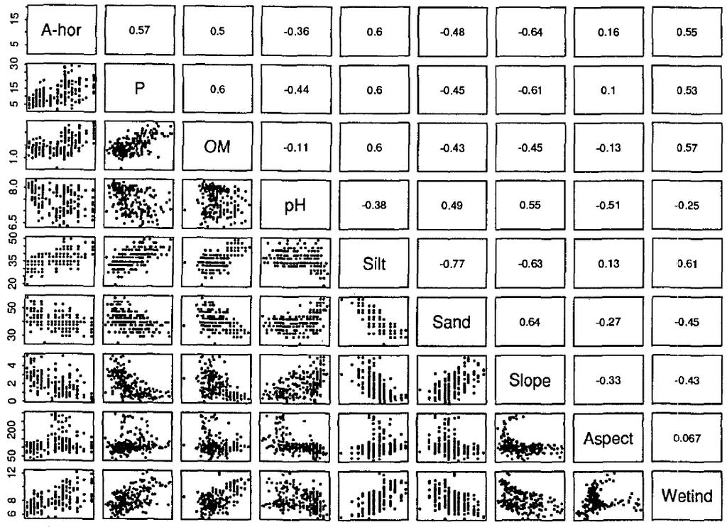
7 Topographic index not a new concept (Kirby + Beven late 70 s) - used to describe the spatial distribution of the soil moisture and soil properties related landscape processes. - as contributing area (specific catchment area) increases and slope steepness decreases, topographic index and soil moisture content increase. - can lead to higher correlations of soil moisture with topographic index than with specific catchment area and slope steepness. Topographic index controls : flow accumulation, soil moisture, distribution of saturation zones, depth of water table, evapotranspiration, thickness of soil horizons, organic matter, ph, silt and sand content, plant cover distribution.
8 Topographic Index λ = i ln α i tan βi λ i = topographic index of grid cell, i α i = the upslope contributing area per unit length of contour β i = topographic slope of the cell Topographic Index raster calculator-ready [TI] = Ln ( ( [FlowAcc] + 1 ) / ([Slope] / ) )


9 Overland flow generating areas Infiltration Infiltration Interflow Saturated Runoff Interflow Gully formation Exposed rock

10 Maybar, Ethiopia Chance that rainfall intensity will exceed infiltration capacity is very small Infiltration rate or rainfall intensity cm/hr Medium infiltration rate Rainfall Intensity Minimum infiltration rate Probability of Excedance
11

12
13
14 Soil-Topography Dynamics (1) Ethiopia, borrowed from Solomon Seyoum Soil Layer 1: SOL_CBN CLAY% SILT% SAND% y = x R² = Soil Property y = x R² = y = x R² = TI Class
15 Nothing new here. Next image borrowed from Moore et al. 1993
16
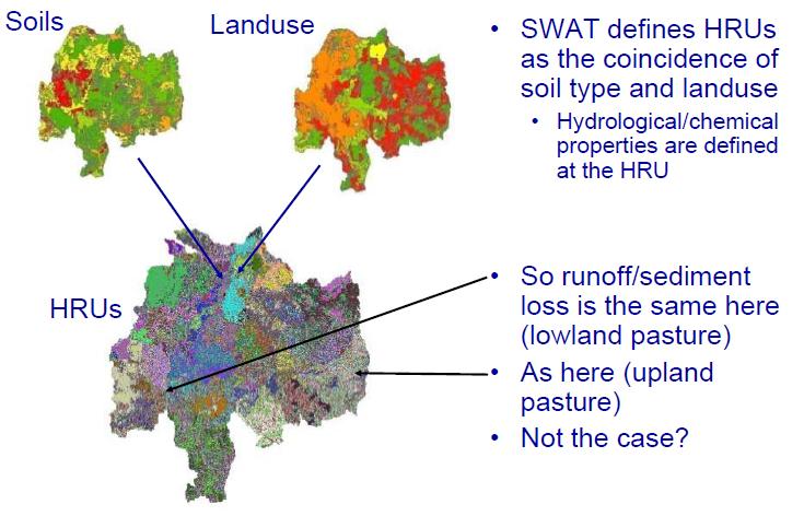
17 Traditional SWAT
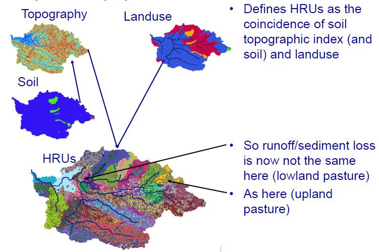
18 SWAT VSA

 b")
")
19 a SWAT-VSA Soil Water (mm) b SWAT Soil Water (mm)
 b SWAT")


20 a SWAT-VSA Runoff (mm) b SWAT Runoff (mm)
21 Arc Toolbox to Expand ArcSWAT Allows better initialization based on type of SWAT modeling project you want to perform. International FAO soils Low resolution, but works anywhere Aspect Better surface energy budget Crop centric modeling Snow dominated processes Elevation Better temperature and precipitation distribution Crop Centric modeling Snow dominated processes Intra-basin hydrology Topographic Index Hill slope hydrology Surface and interflow routing (In the latest version of SWAT, per Arnold)

22 Automating the Topographic Index in ArcGIS


23 Simple add to ArcSWAT Initialization Select project Select database Choose what you want represented Topographic Index Elevation increment in meters D8 Aspect

24 Just Soil, only 2 classes for 1200km 2 Two Few for your project?

25 Elevation at 500m/5 0 increments 7 soils

26 D8 Aspect 16 soils
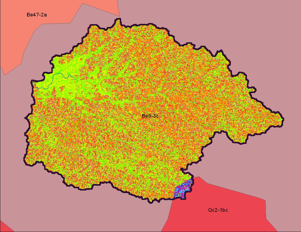
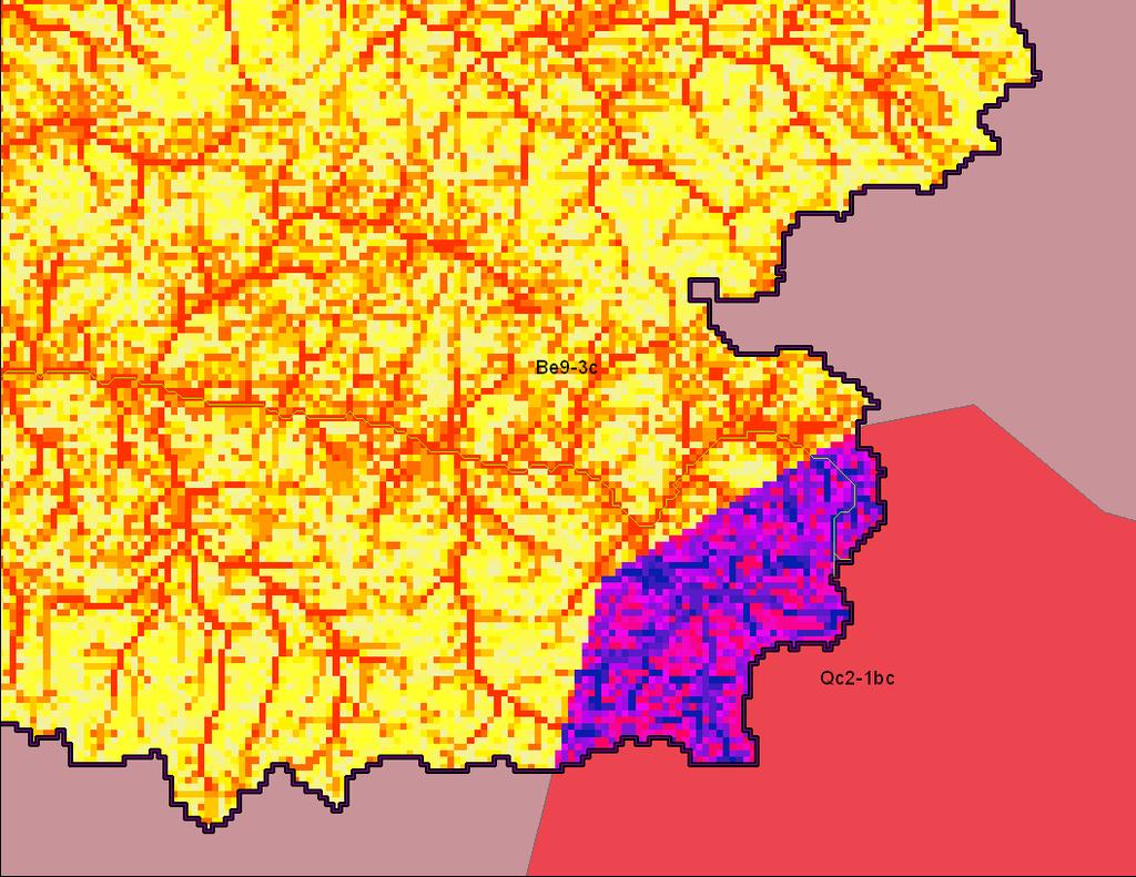
27 Topographic Index 20 soils


28 Elevation 500m, TI, D8 Aspect 504 soils

29 Building a Topography Layer ArcSWAT Delineation vs TopoSWAT
30 Current Toolbox Status Currently supported on ArcSWAT2009 Arc10 Porting to ArcSWAT 9.x Porting to ArcSWAT2012 (Arc10) Available from
31 Conclusions Adding topography is only really necessary for those that want to model energy based processes, management practices, climate change effects in watersheds general speaking.. hydrology. Hoping for initial feed back to support the integration of these simple steps into the main ArcSWAT distribution, but the toolbox needs more testing before we actively pester for it being included.
M.L. Kavvas, Z. Q. Chen, M. Anderson, L. Liang, N. Ohara Hydrologic Research Laboratory, Civil and Environmental Engineering, UC Davis
 Assessment of the Restoration Activities on Water Balance and Water Quality at Last Chance Creek Watershed Using Watershed Environmental Hydrology (WEHY) Model M.L. Kavvas, Z. Q. Chen, M. Anderson, L.
Chapter 3 Physical Factors Affecting Runoff
 Chapter 3 Physical Factors Affecting Runoff Copyright 2003 David G Tarboton, Utah State University CHAPTER 3: PHYSICAL FACTORS AFFECTING RUNOFF The general climatic regime controls the total volume of
Ramos MC, Martínez-Casasnovas JA & Balasch JC
 Runoff and soil loss prediction in a vineyard area at very detail scale using SWAT: comparison between dry and wet years Runoff and soil loss prediction in a vineyard area at very detailed scale Ramos
USING ARCSWAT TO EVALUATE EFFECTS OF LAND USE CHANGE ON WATER QUALITY. Adam Gold Geog 591
 USING ARCSWAT TO EVALUATE EFFECTS OF LAND USE CHANGE ON WATER QUALITY Adam Gold Geog 591 Introduction The Soil and Water Assessment Tool (SWAT) is a hydrologic transport model with an objective to predict
Introduction. Welcome to the Belgium Study Abroad Program. Courses:
 Introduction Welcome to the Belgium Study Abroad Program Courses: AGSM 335: Soil and Water Management BAEN 460: Principals of Environmental Hydrology BAEN 460 / AGSM 335 Combined lecture and HW sessions
Lecture 9A: Drainage Basins
 GEOG415 Lecture 9A: Drainage Basins 9-1 Drainage basin (watershed, catchment) -Drains surfacewater to a common outlet Drainage divide - how is it defined? Scale effects? - Represents a hydrologic cycle
DEVELOPMENT AND APPLICATION OF A PHYSICALLY BASED LANDSCAPE WATER BALANCE IN THE SWAT MODEL. A Thesis. of Cornell University
 DEVELOPMENT AND APPLICATION OF A PHYSICALLY BASED LANDSCAPE WATER BALANCE IN THE SWAT MODEL A Thesis Presented to the Faculty of the Graduate School of Cornell University In Partial Fulfillment of the
Using a topographic index to distribute variable source area runoff predicted with the SCS curve-number equation
 HYDROLOGICAL PROCESSES Hydrol. Process. 18, 2757 2771 (24) Published online 3 June 24 in Wiley InterScience (www.interscience.wiley.com). DOI: 1.12/hyp.1494 Using a topographic index to distribute variable
CHAPTER FIVE Runoff. Engineering Hydrology (ECIV 4323) Instructors: Dr. Yunes Mogheir Dr. Ramadan Al Khatib. Overland flow interflow
 Instructors: Dr. Yunes Mogheir Dr. Ramadan Al Khatib. Overland flow interflow") Engineering Hydrology (ECIV 4323) CHAPTER FIVE Runoff Instructors: Dr. Yunes Mogheir Dr. Ramadan Al Khatib Overland flow interflow Base flow Saturated overland flow ١ ٢ 5.1 Introduction To Runoff Runoff
Engineering Hydrology (ECIV 4323) CHAPTER FIVE Runoff Instructors: Dr. Yunes Mogheir Dr. Ramadan Al Khatib Overland flow interflow Base flow Saturated overland flow ١ ٢ 5.1 Introduction To Runoff Runoff
Runoff and soil loss. (Quantification and modeling of watershed discharge and sediment yield) Kassa Tadele (Dr.Ing) Arba Minch University
 Kassa Tadele (Dr.Ing) Arba Minch University") Runoff and soil loss (Quantification and modeling of watershed discharge and sediment yield) Kassa Tadele (Dr.Ing) Arba Minch University Part I. Runoff Contents 1. Fundamental Concepts 2. Generation of
Runoff and soil loss (Quantification and modeling of watershed discharge and sediment yield) Kassa Tadele (Dr.Ing) Arba Minch University Part I. Runoff Contents 1. Fundamental Concepts 2. Generation of
Definitions 3/16/2010. GG22A: GEOSPHERE & HYDROSPHERE Hydrology
 GG22A: GEOSPHERE & HYDROSPHERE Hydrology Definitions Streamflow volume of water in a river passing a defined point over a specific time period = VxA discharge m 3 s -1 Runoff excess precipitation - precipitation
Use of GIS to identify potential sites for small hydroelectric plants: general concepts and example of application
 Use of GIS to identify potential sites for small hydroelectric plants: general concepts and example of application Joanne Félix Antoine Dubas STUCKY SA STUCKY SA Rue du lac 33 Rue du lac 33 P/O box P/O
2
 1 2 3 4 5 6 The program is designed for surface water hydrology simulation. It includes components for representing precipitation, evaporation, and snowmelt; the atmospheric conditions over a watershed.
Water Resources on PEI: an overview and brief discussion of challenges
 Water Resources on PEI: an overview and brief discussion of challenges Components: Components and links Atmospheric water Surface water (including glacial water) Groundwater Links: Precipitation (atm(
The Fourth Assessment of the Intergovernmental
 Hydrologic Characterization of the Koshi Basin and the Impact of Climate Change Luna Bharati, Pabitra Gurung and Priyantha Jayakody Luna Bharati Pabitra Gurung Priyantha Jayakody Abstract: Assessment of
Using SWAT model to evaluate the impact of community-based soil and water conservation interventions for an Ethiopian watershed
 Using SWAT model to evaluate the impact of community-based soil and water conservation interventions for an Ethiopian watershed Hailu Kendie Addis Amhara Regional Agricultural Research Institute, Bahir
Prediction in ungauged basins (PUB) - (still) the holy grail in hydrology. Thomas Skaugen Norwegian Water Resources and Energy directorate, Norway
 - (still) the holy grail in hydrology. Thomas Skaugen Norwegian Water Resources and Energy directorate, Norway") Prediction in ungauged basins (PUB) - (still) the holy grail in hydrology Thomas Skaugen Norwegian Water Resources and Energy directorate, Norway PUB (2003-2012) Wonderful theme for a community effort.
Prediction in ungauged basins (PUB) - (still) the holy grail in hydrology Thomas Skaugen Norwegian Water Resources and Energy directorate, Norway PUB (2003-2012) Wonderful theme for a community effort.
Modeling Nutrient and Sediment Losses from Cropland D. J. Mulla Dept. Soil, Water, & Climate University of Minnesota
 Modeling Nutrient and Sediment Losses from Cropland D. J. Mulla Dept. Soil, Water, & Climate University of Minnesota Watershed Management Framework Identify the problems and their extent Monitor water
SWATMODEL: A MULTI-OPERATING SYSTEM, MULTI-PLATFORM SWAT MODEL PACKAGE IN R 1
 AMERICAN WATER RESOURCES ASSOCIATION SWATMODEL: A MULTI-OPERATING SYSTEM, MULTI-PLATFORM SWAT MODEL PACKAGE IN R 1 Daniel R. Fuka, M. Todd Walter, Charlotte MacAlister, Tammo S. Steenhuis, and Zachary
Mission. Selected Accomplishments from Walnut Gulch. Facilities. To develop knowledge and technology to conserve water and soil in semi-arid lands
 USDA-ARS Southwest Watershed Research Center Mission Sound Science for Watershed Decisions To develop knowledge and technology to conserve water and soil in semi-arid lands ARS Watershed Locations Selected
Issues include coverage gaps, delays, measurement continuity and consistency, data format and QC, political restrictions
 Satellite-based Estimates of Groundwater Depletion, Ph.D. Chief, Hydrological Sciences Laboratory NASA Goddard Space Flight Center Greenbelt, MD Groundwater Monitoring Inadequacy of Surface Observations
Hydrology and Water Management. Dr. Mujahid Khan, UET Peshawar
 Hydrology and Water Management Dr. Mujahid Khan, UET Peshawar Course Outline Hydrologic Cycle and its Processes Water Balance Approach Estimation and Analysis of Precipitation Data Infiltration and Runoff
An Overview of JULES. Christina Bakopoulou
 An Overview of JULES Christina Bakopoulou JULES, MOSES AND TRIFFID JULES (Joint UK Land Environment Simulator) is a new land surface model Joint initiative: NERC through the CEH, CLASSIC, QUEST and the
July, International SWAT Conference & Workshops
 Analysis of the impact of water conservation measures on the hydrological response of a medium-sized watershed July, 212 212 International SWAT Conference & Workshops ANALYSIS OF THE IMPACT OF WATER CONSERVATION
Soil Processes: SVAT, ET, and the Subsurface. Summary
 Soil Processes: SVAT, ET, and the Subsurface CIVE 781: Principles of Hydrologic Modelling University of Waterloo Jun 19 24, 2017 Summary The role of soil and vegetation in the water cycle Soil Physics:
EFFECTS OF WATERSHED TOPOGRAPHY, SOILS, LAND USE, AND CLIMATE ON BASEFLOW HYDROLOGY IN HUMID REGIONS: A REVIEW
 PROGRESS IN PHYSICAL GEOGRAPHY EFFECTS OF WATERSHED TOPOGRAPHY, SOILS, LAND USE, AND CLIMATE ON BASEFLOW HYDROLOGY IN HUMID REGIONS: A REVIEW KATIE PRICE 2011 Presented by: Jordan Martin Article Overview
Linking hydrology to erosion modelling in a river basin decision support and management system
 Integrated Water Resources Management (Proceedings of a symposium held at Davis. California. April 2000). I APIS Publ. no. 272. 2001. 243 Linking hydrology to erosion modelling in a river basin decision
Application of a Basin Scale Hydrological Model for Characterizing flow and Drought Trend
 Application of a Basin Scale Hydrological Model for Characterizing flow and Drought Trend 20 July 2012 International SWAT conference, Delhi INDIA TIPAPORN HOMDEE 1 Ph.D candidate Prof. KOBKIAT PONGPUT
Climate Change in the Columbia Basin. Stephanie Smith Manager of Hydrology, BC Hydro
 Climate Change in the Columbia Basin Stephanie Smith Manager of Hydrology, BC Hydro June 20, 2017 Outline Climate change in the Columbia River basin What has happened? What could happen? What can we do
1.6 Influence of Human Activities and Land use Changes on Hydrologic Cycle
 1.6 Influence of Human Activities and Land use Changes on Hydrologic Cycle Watersheds are subjected to many types of changes, major or minor, for various reasons. Some of these are natural changes and
Urbanization effects on the hydrology of the Atlanta area, Georgia (USA)
") 14/06/01 Impact of Human Activity on Groundwater Dynamics (Proceedings of a symposium held during the Sixth IAHS Scientific Assembly at Maastricht, The Netherlands, July 2001). IAHS Publ. no. 269, 2001.
14/06/01 Impact of Human Activity on Groundwater Dynamics (Proceedings of a symposium held during the Sixth IAHS Scientific Assembly at Maastricht, The Netherlands, July 2001). IAHS Publ. no. 269, 2001.
CEE3430 Engineering Hydrology
 CEE3430 Engineering Hydrology Practice Exam (There are multiple practice questions here A 110 min test will likely not have more than four questions) 1. Water Balance Write the water balance as Δ Where
Uncertainty in Hydrologic Modelling for PMF Estimation
 Uncertainty in Hydrologic Modelling for PMF Estimation Introduction Estimation of the Probable Maximum Flood (PMF) has become a core component of the hydrotechnical design of dam structures 1. There is
Wolf Creek Cold Regions Model Set-up, Parameterisation and Modelling Summary
 Wolf Creek Cold Regions Model Set-up, Parameterisation and Modelling Summary Centre for Hydrology Report No. 8 John Pomeroy, Centre for Hydrology, University of Saskatchewan, Saskatoon Olga M. Semenova,
Page 1. Name:
 Name: 7574-1 - Page 1 1) The diagram below shows the result of leaving an empty, dry clay flowerpot in a full container of water for a period of time. The water level in the container dropped to level
Write It! Station Directions
 Write It! Station Directions It is recommended that you have completed at least two of the following stations before working at this station. -Read It! -Explore It! -Watch It! -Research It! Answer each
The Noah-MP Land Surface Model. Michael Barlage Research Applications Laboratory National Center for Atmospheric Research
 The Noah-MP Land Surface Model Michael Barlage Research Applications Laboratory National Center for Atmospheric Research 1 2 Conceptual Land Surface Processes Precipitation Transpiration Canopy Water Evaporation
Incorporating variable source area hydrology into a curve-number-based watershed model
 HYDROLOGICAL PROCESSES Hydrol. Process. 2, 342 343 (27) Published online 24 July 27 in Wiley InterScience (www.interscience.wiley.com).6556 Incorporating variable source area hydrology into a curve-number-based
SCS-CN HYDROLOGIC MODELING OF THE GREAT DISMAL SWAMP WITH HEC-HMS
 SCS-CN HYDROLOGIC MODELING OF THE GREAT DISMAL SWAMP WITH HEC-HMS Committee: by Timothy R. Larson A Thesis Submitted to the Graduate Faculty of George Mason University in Partial Fulfillment of The Requirements
ENVS 435: Watershed Management. 3 Credits INSTR.: Dr. R.M. Bajracharya
 ENVS 435: Watershed Management 3 Credits INSTR.: Dr. R.M. Bajracharya Unit 1: Introduction - Watershed Concepts Definitions of watershed The elevated line separating the head streams which are tributaries
Water Budget IV: Soil Water Processes P = Q + ET + G + ΔS
 Water Budget IV: Soil Water Processes P = Q + ET + G + ΔS Infiltration Infiltration capacity: The maximum rate at which water can enter soil. Infiltration capacity curve: A graph showing the time-variation
Runoff Processes. Daene C. McKinney
 CE 374 K Hydrology Runoff Processes Daene C. McKinney Watershed Watershed Area draining to a stream Streamflow generated by water entering surface channels Affected by Physical, vegetative, and climatic
Runoff Risk Advisory Forecast (RRAF) for Wisconsin
 for Wisconsin") Runoff Risk Advisory Forecast (RRAF) for Wisconsin Development & Production of a Real-Time Decision Support System for Wisconsin Manure Producers Dustin Goering North Central River Forecast Center (NCRFC)
Runoff Risk Advisory Forecast (RRAF) for Wisconsin Development & Production of a Real-Time Decision Support System for Wisconsin Manure Producers Dustin Goering North Central River Forecast Center (NCRFC)
GIS Applications in Water Resources Engineering
 King Fahd University of Petroleum & Minerals City & Regional Planning Department Introduction to Geographic Information Systems Term Paper Presentation GIS Applications in Water Resources Engineering Prepared
Chapter 6. Hydrology. 6.0 Introduction. 6.1 Design Rainfall
 6.0 Introduction This chapter summarizes methodology for determining rainfall and runoff information for the design of stormwater management facilities in the City. The methodology is based on the procedures
ENGINEERING HYDROLOGY
 ENGINEERING HYDROLOGY Prof. Rajesh Bhagat Asst. Professor Civil Engineering Department Yeshwantrao Chavan College Of Engineering Nagpur B. E. (Civil Engg.) M. Tech. (Enviro. Engg.) GCOE, Amravati VNIT,
Coupling Transport and Transformation Model with Land Surface Scheme SABAE- HW: Application to the Canadian Prairies
 HW-1 Coupling Transport and Transformation Model with Land Surface Scheme SABAE- HW: Application to the Canadian Prairies Allan D. Woodbury, Alireza Hejazi Department of Civil Engineering University of
GIS Analysis of Gully Head Erosion Rates on High Ridge Tree Farm in Winona County, Minnesota
 GIS Analysis of Gully Head Erosion Rates on High Ridge Tree Farm in Winona County, Minnesota Lisa M. Worrell Department of Resource Analysis, Saint Mary s University of Minnesota, Winona, MN 55987. Keywords:
Peatland Carbon Stocks and Fluxes:
 Peatland Carbon Stocks and Fluxes: monitoring, measurements and modelling Dr Andreas Heinemeyer ah126@york.ac.uk University of York, Stockholm Environment Institute UNFCCC 24 th October 2013 South Africa:
Hydrology Experiment Design: An Open-Ended Lab to Foster Student Engagement and Critical Thinking
 Paper ID #14671 Hydrology Experiment Design: An Open-Ended Lab to Foster Student Engagement and Critical Thinking Dr. Cara J Poor P.E., University of Portland Dr. Poor teaches many of the integral undergraduate
Using GIS, Terrain Attributes and Hydrologic Models to Predict the Risk of Soil Erosion and Stream Water Deterioration Caused by Forest Roads
 Using GIS, Terrain Attributes and Hydrologic Models to Predict the Risk of Soil Erosion and Stream Water Deterioration Caused by Forest Roads a Farabi, H. and b James, R. a Gorgan University (Iran) and
Comparison of Recharge Estimation Methods Used in Minnesota
 Comparison of Recharge Estimation Methods Used in Minnesota by Geoffrey Delin, Richard Healy, David Lorenz, and John Nimmo Minnesota Ground Water Association Spring Conference Methods for Solving Complex
PREDICTION OF FLOW DURATION CURVES FOR USE IN HYDROPOWER ANALYSIS AT UNGAGED SITES IN KOSRAE, FSM
 PREDICTION OF FLOW DURATION CURVES FOR USE IN HYDROPOWER ANALYSIS AT UNGAGED SITES IN KOSRAE, FSM By Dr. Leroy F. Heitz P.E. Dr. Shahram Khosrowpanah P.E. Technical Report No. 137 June 2012 PREDICTION
Potential uses of Indices (PDSI,CMI) and other Indicators to estimate drought in Barbados. Presented by: Shontelle Stoute
 and other Indicators to estimate drought in Barbados. Presented by: Shontelle Stoute") Potential uses of Indices (PDSI,CMI) and other Indicators to estimate drought in Barbados Presented by: Shontelle Stoute What is drought? Insufficient quantity of water, relative to what is normal, to
Potential uses of Indices (PDSI,CMI) and other Indicators to estimate drought in Barbados Presented by: Shontelle Stoute What is drought? Insufficient quantity of water, relative to what is normal, to
Energy Balance and Evapotranspiration Measurement
 Energy Balance and Evapotranspiration Measurement Yu-Jun Cui Ecole Nationale des Ponts et Chaussée, Paris, France Jorge G. Zornberg The University of Texas at Austin, USA ABOUT THIS TOPIC - Multi-disciplinary
Appendix 4 ADB. IN THE 6 CI's RIVER BASIN TERRITORY - PACKAGE B. Final Report B.2 - Strategic Spatial Planning
 ADB TA 7189-INO: INSTITUTIONAL STRENGTHENING FOR INTEGRATED WATER RESOURCES MANAGEMENT (IWRM) IN THE 6 CI's RIVER BASIN TERRITORY - PACKAGE B Final Report B.2 - Strategic Spatial Planning Appendix 4 Modeling
Lecture 19. Landfill hydrology
 Lecture 19 Landfill hydrology Landfill hydrology Water Pathways Rainfall/Snowfall Transpiration Snow Evaporation Interception Interception Evaporation Runoff Snow Melt Snow Accumulation Plant Growth Infiltration
Flood forecasting model based on geographical information system
 doi:10.5194/piahs-368-192-2015 192 Remote Sensing and GIS for Hydrology and Water Resources (IAHS Publ. 368, 2015) (Proceedings RSHS14 and ICGRHWE14, Guangzhou, China, August 2014). Flood forecasting model
The evaluation of coupled WRF + Noah-MP and 1-d offline Noah-MP at the FLUXNET sites over Canada
 The evaluation of coupled WRF + Noah-MP and 1-d offline Noah-MP at the FLUXNET sites over Canada Yanping Li, Liang Chen Univ of Saskatchewan Fei Chen, NCAR Alan Barr, Environment Canada I. The calibration
Received 29 May 2002; accepted 9 July 2003
 Journal of Hydrology 284 (2003) 57 76 www.elsevier.com/locate/jhydrol Application of two hydrologic models with different runoff mechanisms to a hillslope dominated watershed in the northeastern US: a
East Maui Watershed Partnership Adapted from Utah State University and University of Wisconsin Ground Water Project Ages 7 th -Adult
 INTRODUCTION What is groundwater? Water contained in saturated soil and rock materials below the surface of the earth. It is not NEW water, but is recycled water through the hydraulic cycle. The source
Impact of precipitation and temperature on hydrological responses in the Ethiopian Highlands
 Impact of precipitation and temperature on hydrological responses in the Ethiopian Highlands Tatenda Lemann, 1,2,3 Vincent Roth, 1,2,3 Gete Zeleke, 1,3 1 Centre for Development and Environment (CDE), University
EVALUATING A MULTI-VELOCITY HYDROLOGICAL PARAMETERIZATION IN THE AMAZON BASIN
 Annual Journal of Hydraulic Engineering, JSCE, Vol.55 2011 February EVALUATING A MULTI-VELOCITY HYDROLOGICAL PARAMETERIZATION IN THE AMAZON BASIN Roberto Valmir DA SILVA1, Yosuke YAMASHIKI2 and Kaoru TAKARA3
DRAINAGE PLAN OF NAU S EASTBURN EDUCATION AND GAMMAGE BUILDINGS FINAL PROPOSAL
 MAY 10, 2016 DRAINAGE PLAN OF NAU S EASTBURN EDUCATION AND GAMMAGE BUILDINGS FINAL PROPOSAL Connor Klein, Jiangnan Yi, Yuzhi Zhang, Yi Yang NORTHERN ARIZONA UNIVERSITY NAU Water Buffalo Engineering Table
The Effect of Surface Texture on Evaporation, Infiltration and Storage Properties of Paved Surfaces
 The Effect of Surface Texture on Evaporation, Infiltration and Storage Properties of Paved Surfaces M. Mansell* and F. Rollet School of Engineering and Science, University of the West of Scotland, Paisley
Detailed spatial analysis of the plausibility of surface runoff and sediment yields at HRU level in a mountainous watershed in China
 Christian-Albrechts-Universität zu Kiel Institut für Natur- und Ressourcenschutz Detailed spatial analysis of the plausibility of surface runoff and sediment yields at HRU level in a mountainous watershed
Soil Properties that influence detachment and runoff
 Soil Properties that influence detachment and runoff Texture Structure Aggregation Density/compaction Wettability Antecedent soil moisture Organic Matter Sandy soils Sands are easily detacted However,
Uncertainty in hydrologic impacts of climate change: A California case study
 Uncertainty in hydrologic impacts of climate change: A California case study Ed Maurer Civil Engineering Dept. Santa Clara University Photos from USGS Motivating Questions What are potential impacts of
Influence of spatial and temporal resolutions in hydrologic models
 Influence of spatial and temporal resolutions in hydrologic models Ingjerd Haddeland (University of Oslo) Dennis P. Lettenmaier (University of Washington) Thomas Skaugen (University of Oslo) Outline Background,
NREM 407/507 WATERSHED MANAGEMENT
 NREM 407/507 WATERSHED MANAGEMENT Please pick up Syllabus, Reading Material & Today s Lab on the Table in the Front Dick Schultz Instructor Sara Berges Teaching Assistant January 13, 2009 1. Conduct Get
Title: Modelling of Cascade Dams & Reservoir Operation for Optimal Water Use: Application to the Omo River Basin, Ethiopia
 . Teshome Seyoum Bachilor Degree in Agric-al Engineering, Alemaya University,Ethiopia, 1995 Work in Water supply & irrigation projects from 1996-2005 Master Degree in Irrigation Engineering, Arbaminch
Chehalis Basin Strategy Causes of Extreme Flooding. October 11, 2016 Policy Workshop
 Chehalis Basin Strategy Causes of Extreme Flooding October 11, 2016 Policy Workshop Agenda Hydrology o Precipitation o Flow Climate Change Effects Land Use o Channel straightening and incision o Riparian
WATER USES and AVAILABLE RESOURCES
 WATER USES and AVAILABLE RESOURCES DEMAND Estimating the demand (domestic and industrial) implies generally to determine a daily equivalent discharge that includes all the uses, cumulated and averaged
Estimating Stormwater Runoff from the 3D-model of an Urban Area in Istanbul
 198 Estimating Stormwater Runoff from the 3D-model of an Urban Area in Istanbul Muhammed Ali Örnek 1, Melike Ersoy 2, Yasin Çağatay Seçkin 3 1 Istanbul Technical University, Istanbul/Turkey maornek@itu.edu.tr
UNIT HYDROGRAPH AND EFFECTIVE RAINFALL S INFLUENCE OVER THE STORM RUNOFF HYDROGRAPH
 UNIT HYDROGRAPH AND EFFECTIVE RAINFALL S INFLUENCE OVER THE STORM RUNOFF HYDROGRAPH INTRODUCTION Water is a common chemical substance essential for the existence of life and exhibits many notable and unique
Answer Test Questions Finish Climate Discussion
 NREM 301 Forest Ecology & Soils Day 30 December 4, 2008 Answer Test Questions Finish Climate Discussion Take-Home Test Due Dec 11 5 pm No Final Exam Lab Today Finish & e-mail all materials to Dick Class
The Islamic University of Gaza- Civil Engineering Department Sanitary Engineering- ECIV 4325 L5. Storm water Management
 The Islamic University of Gaza- Civil Engineering Department Sanitary Engineering- ECIV 4325 L5. Storm water Management Husam Al-Najar Storm water management : Collection System Design principles The Objectives
Ontario Flow Assessment Tool
 Ministry of Natural Ministry Resources of Natural and Resources Forestry Ontario Flow Assessment Tool Spatial Data Infrastructure Unit Steve Damaia Acting Far North Project Manager steve.damaia@ontario.ca
EVALUATION OF HYDROLOGIC AND WATER RESOURCES RESPONSE TO METEOROLOGICAL DROUGHT IN THESSALY, GREECE
 EVALUATION OF HYDROLOGIC AND WATER RESOURCES RESPONSE TO METEOROLOGICAL DROUGHT IN THESSALY, GREECE A. LOUKAS*, AND L. VASILIADES Laboratory of Hydrology and Water Systems Analysis,, Volos, Greece *E-mail:
SUSTAINABLE LAND USE. A New Paradigm in
 Marco Schmidt A New Paradigm in SUSTAINABLE LAND USE The global change in land use and its impact on the hydrology reduces evaporation and precipitation rates and releases heat. In urban areas, the priority
Event and Continuous Hydrological Modeling with HEC- HMS: A Review Study
 Event and Continuous Hydrological Modeling with HEC- HMS: A Review Study Sonu Duhan *, Mohit Kumar # * M.E (Water Resources Engineering) Civil Engineering Student, PEC University Of Technology, Chandigarh,
Topographic Influence on the Seasonal and Interannual Variation of Water and Energy Balance of Basins in North America
 1MAY 2001 CHEN AND KUMAR 1989 Topographic Influence on the Seasonal and Interannual Variation of Water and Energy Balance of Basins in North America JI CHEN AND PRAVEEN KUMAR Environmental Hydrology and
Hydrology Forecasting using SWAT Hydrologic Models for the 2014 California Drought
 Hydrology Forecasting using SWAT Hydrologic Models for the 2014 California Drought Guobiao Huang and Francis Chung Bay-Delta Office CA Department of Water Resources CWEMF Annual Meeting March 10, 2015
Phase 1 Part 2 CSO Control Plan Wellington Avenue CSO Facility. Hydraulic Modeling Software Selection
 DRAFT Technical Memorandum Phase 1 Part 2 CSO Control Plan Wellington Avenue CSO Facility Hydraulic Modeling Software Selection Prepared for: City of Newport Public Works Department 70 Halsey Street Newport,
MODELING SEDIMENT AND PHOSPHORUS YIELDS USING THE HSPF MODEL IN THE DEEP HOLLOW WATERSHED, MISSISSIPPI
 MODELING SEDIMENT AND PHOSPHORUS YIELDS USING THE HSPF MODEL IN THE DEEP HOLLOW WATERSHED, MISSISSIPPI Jairo Diaz-Ramirez, James Martin, William McAnally, and Richard A. Rebich Outline Background Objectives
Overview of the Surface Hydrology of Hawai i Watersheds. Ali Fares Associate Professor of Hydrology NREM-CTAHR
 Overview of the Surface Hydrology of Hawai i Watersheds Ali Fares Associate Professor of Hydrology NREM-CTAHR 5/23/2008 Watershed Hydrology Lab 1 What is Hydrology? Hydrology is the water science that
Hydrologic Engineering Center. Training Course on. Hydrologic Modeling with HEC-HMS. Davis, CA. Course Description
 Hydrologic Engineering Center Training Course on Hydrologic Modeling with HEC-HMS Davis, CA Course Description The course provides an introduction to HEC-HMS for new users, focusing both on using the program
Surface Irrigation Suitability Assessment of the Soils of Almanaqil Ridge, Gezira State, Sudan
 IJETST-Vol. 2 Issue 7 Pages 23-2814 July ISSN 2348-94 2015 International Journal of Emerging Trends in Science and Technology Surface Irrigation Suitability Assessment of the Soils of Almanaqil Ridge,
DRAFT USER S REFERENCE GUIDE
 DRAFT USER S REFERENCE GUIDE Revised Universal Soil Loss Equation Version 2 (RUSLE2) Prepared for USDA-Agricultural Research Service Washington, D.C. May 15, 2008 2 Acknowledgements RUSLE2 was developed
Assessing the impacts of climate change on groundwater and dependent ecosystems: Experiences from cold regions (Finland) Bjørn Kløve
 Bjørn Kløve") Assessing the impacts of climate change on groundwater and dependent ecosystems: Experiences from cold regions (Finland) Bjørn Kløve Case Study Aquifers 7 FP project 25 partners 2009-2013 About 100 researchers
Assessing the impacts of climate change on groundwater and dependent ecosystems: Experiences from cold regions (Finland) Bjørn Kløve Case Study Aquifers 7 FP project 25 partners 2009-2013 About 100 researchers
MMEA, WP5.2.7 Mining Deliverable D
 Research Report Helsinki August 2015 Panu Juntunen (SYKE) MMEA, WP5.2.7 Mining Deliverable D5.2.7.8 Water balance modeling using weather forecast CLEEN LTD ETELÄRANTA 10 P.O. BOX 10 FI-00130 HELSINKI FINLAND
Automated Method to Develop a Clark Synthetic Unit Hydrograph within ArcGIS
 Automated Method to Develop a Clark Synthetic Unit Hydrograph within ArcGIS by Michael Follum PURPOSE: This Coastal and Hydraulics Engineering technical note (CHETN) describes an automated method to develop
URBAN FLOODING: HEC-HMS
 1.0 Introduction URBAN FLOODING: HEC-HMS -Sunil Kumar, Director, NWA All major ancient civilisations were developed in the river valleys because river served as source of water, food, transportation and
Utilization of the SWAT Model and Remote Sensing to Demonstrate the Effects of Shrub Encroachment on a Small Watershed
 Utilization of the SWAT Model and Remote Sensing to Demonstrate the Effects of Shrub Encroachment on a Small Watershed Jason Afinowicz Department of Biological and Agricultural Engineering Texas A&M University
Joint Research Centre (JRC)
") Joint Research Centre (JRC) Marco Pastori and Faycal Bouraoui IES - Institute for Environment and Sustainability Ispra - Italy http://ies.jrc.ec.europa.eu/ http://www.jrc.ec.europa.eu/ CONTENT Introduction
Joint Research Centre (JRC) Marco Pastori and Faycal Bouraoui IES - Institute for Environment and Sustainability Ispra - Italy http://ies.jrc.ec.europa.eu/ http://www.jrc.ec.europa.eu/ CONTENT Introduction
Where Did the Water Go?: Watershed Study Middle School Sample Classroom Assessment
 Where Did the Water Go?: Watershed Study Middle School Sample Classroom Assessment Introduction In this task, students will demonstrate their understanding of the water cycle by considering the inputs
Distributed modeling of landsurface water and energy budgets in the inland Heihe river basin of China
 Author(s) 2009. This work is distributed under the Creative Commons Attribution 3.0 License. Hydrology and Earth System Sciences Distributed modeling of landsurface water and energy budgets in the inland
State of West Virginia Source Water Assessment and Protection Program Source Water Assessment Report
 State of West Virginia Source Water Assessment and Protection Program Source Water Assessment Report Beckley Water Company Raleigh County PWSID: WV3304104 Prepared by: West Virginia Department of Health
Review of existing simulation based flood frequency frameworks in Greece
 European Procedures for Flood Frequency Estimation FLOODFREQ COST ACTION ES0901 3 rd Management Committee Meeting, Prague, 28 29 October 2010 WG3: Use of rainfall runoff models for flood frequency estimation
AN INTEGRATED GROUNDWATER RECHARGE AND FLOW MODEL TO PREDICT BASE FLOW
 AN INTEGRATED GROUNDWATER RECHARGE AND FLOW MODEL TO PREDICT BASE FLOW By XIAOJING NI A THESIS Submitted to Michigan State University in partial fulfillment of the requirements for the degree of Civil