CLARE COUNTY COUNCIL. STRATEGIC ENVIRONMENTAL ASSESSMENT Clare County Development Plan a) Environmental Report
|
|
|
- Jacob Parrish
- 6 years ago
- Views:
Transcription
 Environmental Report This Clare County Development Plan")

1 CLARE COUNTY COUNCIL STRATEGIC ENVIRONMENTAL ASSESSMENT Clare County Development Plan a) Environmental Report This Clare County Development Plan was adopted on 10th January 2011 and is effective from 7th February This is an interim printed version Planning, Land Use and Transportation Clare County Council
2
3 Table of Contents List of Tables...i List of Figures... ii List of Figures... ii List of Maps... ii Abbreviations... iii Abbreviations... iii Glossary... v Chapter 1: SEA Introduction and Background : Introduction and Terms of Reference : SEA Definition and Role : Legislative and Guidelines Context : SEA Process : Integration of the County Development Plan, SEA and Habitats Directive Assessment : Implications of SEA for the Plan...5 Chapter 2: Strategic Environmental Assessment Methodology : Introduction : SEA Stages : Legislative Conformance : Technical/Difficulties Encountered during the Process Chapter 3: The SEA Process: Relevant International and National Policy Documents, Strategies and Guidelines : Introduction - Hierarchy of Strategic Actions : Relevant International Legislation and Policy : National Policies, Plans and Programmes/National Policy Documents : Regional - Relevant Policies and Plans at Regional Level : County - Relevant Policies and Plans at County Level Chapter 4: Summary of the Key Objectives of the Clare County Development Plan : Introduction : Nature and Lifespan of the Clare County Development Plan : Plan Vision and Strategic Goals : Main Goals of Clare County Development Plan : Interaction with Relevant Planning Policy : Location and Nature of Proposed Development within the County during the Lifetime of the Plan : Settlement Hierarchy Proposed Settlement Structure : Environmental Protection Objectives : Alternatives Chapter 5: Consultation : Introduction : Timeframe Review Process and Consultation : Consultation during the SEA Process Chapter 6: Environmental Parameter Baseline of County Clare : Introduction : Environmental Parameters : Technical Difficulties Encountered and Information Gaps : Biodiversity, Flora and Fauna : Population, Human Health and Quality of Life : Soil and Geology : Water : Air and Climate : Material Assets : Cultural Heritage including Architectural and Archaeological Heritage : Landscape Chapter 7: Strategic Environmental Objectives, Targets and Indicators
4 7.1: Introduction : Development of SEA Objectives Chapter 8: Alternative Plan Scenarios Identification, Description and Evaluation : Introduction : Identification and Description of Alternative Plan Scenarios : Evaluation against SEOs : Conclusion The Preferred Scenario Chapter 9: Evaluation of the Development Plan Objectives : Introduction : Methodology Chapter 10: Mitigation Measures : Introduction : SEA Recommendations : Mitigation Measures Chapter 11: Monitoring Programme : Introduction : Responsibilities : Indicators, Targets and Thresholds : Reporting : Conclusion References SEA Process Checklist
5 List of Tables Table 1.1: An Outline of the Integrated Development Plan Review, the SEA Process and Habitat Directive Assessment...3 Table 2.1: Summary of the SEA Process...6 Table 4.1: Mid West Region Population Targets by Table 5.1: General Timeframe for the Review Process Table 5.2: Informal Review Notification sent to Prescribed Environmental Bodies and other Interested Parties Table 5.3: Public Information Workshop Details Table 5.4: Pre Draft Submissions for the Draft Clare County Development Plan Table 5.5: Elected Members Directions Issued and the Manager s Recommendations Table 6.1: Special Areas of Conservation in County Clare Table 6.2: Special Protection Areas in County Clare Table 6.3a: Natural Heritage Areas in County Clare Table 6.3b: Proposed Natural Heritage Areas in County Clare Table 6.4: Population Growth for the Mid West Region Table 6.5: County Clare: Population Change Table 6.6: Persons Aged 5+ by distance travelled to work, school or college, Table 6.7: Percentage of Unoccupied Houses in County Clare Table 6.8: Population Targets 2022 by County Table 6.9: Population Targets Breakdown Table 6.10: Integrated Pollution Prevention and Control Sites in County Clare. 117 Table 6.11: Energy Related CO 2 Reductions Sought in County Clare Table 6.12: County Clare s Energy Consumption and CO 2 emissions Table 6.13: Category of Roads and their corresponding Lengths in County Clare Table 6.14: Proposed Projects Identified for Future Development Table 6.15: Waste Licenses Issued in County Clare Table 6.16: Water Supply Schemes in County Clare Table 7.2: SEO Internal Compatibility Assessment Table 7.1: Strategic Environmental Protection Objectives Table 8.1: Evaluation of Alternative Scenarios against the SEOs Table 9.1: Criteria for Appraising the Effect of Plan Objectives on SEOs Table 9.2: Strategic Environmental Assessment of the CCDP bjectives Table 11.1: Environmental Objectives, Targets and Indicators
6 List of Figures Figure 4.1: County Clare Plan Area Age Profile (CSO, 2006) Figure 6.1: Plan Area Age Profile in County Clare in Figure 6.2: West Clare Population Change Figure 6.3: Energy Consumption in County Clare Figure 6.4: Water Supply in County Clare Figure 6.5: Types of Wastewater Systems in County Clare List of Maps Map 3.1: Mid West Region Regional Development Zones Map 3.2: Mid West Region Regional Development Zones with Population Targets in County Clare Map 4.1: Clare County Development Plan Area Map 4.2: Settlement Hierarchy for County Clare Map 6.1: Clare County Development Plan Study Area Map 6.2: Ecological Designations in County Clare Map 6.3: Regional Development Zones Map 6.4: Projected Growth to 2017 by Zone Map 6.5: Estimated Percentage of Homes above the Reference Level in Co. Clare Map 6.6: Soil Groups in County Clare Map 6.7: Irish Forestry Soil and Subsoils Map 6.8: Geology Map of County Clare Map 6.9: Geological Heritage Sites in County Clare Map 6.10: Distribution of known Quarrying Activities in Co. Clare Map 6.11: Water Framework Directive Water Management Units Map 6.12: Water Framework Directive Water Status in Co. Clare River Waterbodies Map 6.13: Water Framework Directive Water Status in Co. Clare Lakes Map 6.14: Water Framework Directive Water Status in Co. Clare Coastal and Transitional Waterbodies Map 6.15: Designated Bathing Waters in Co. Clare Map 6.16: Water Framework Directive Water Status in Co. Clare - Shellfish Waters and Salmonid Waters Map 6.17: Catchment Areas for Freshwater Pearl Mussels (Cloon River) Map 6.18: GSI Groundwater Vulnerability Map 6.19: Water Framework Directive Water Status in Co. Clare - Groundwater Map 6.20: Clare County Council In-house Flooding Survey Map 6.21: JBA Consultants Flooding Survey in Co. Clare Map 6.22: Integrated Pollution Prevention and Control Sites Licensed Activities Map 6.23: Road Network in County Clare Map 6.24: Wastewater Treatment Plants in County Clare Map 6.25: Recorded Monuments in County Clare Map 6.26: Architectural Heritage in County Clare Map 6.27: Landscape Character Areas in County Clare Map 6.28: Seascapes in County Clare Map 6.29: Landscape Designations in County Clare
7 ACA C&D CBP CCDP csac CSO DoCMNR DoEHLG EDEN EEA EIA EPA ER EU GHG GIS GSI HDA IGHP IPCC LAP LCEA MWRA MWRPG s NDP NGO NHA NIAH NO 2 NPWS NRA NREAP NSS NTS O 3 OPW P/P PE Pm10 pnha POMS PPP PRP RBD RBMP RMP RPGs RPS RWP S.I. No. SAA SAC Abbreviations List of Abbreviations Architectural Conservation Area Construction and Demolition Customs and Border Protection Clare County Development Plan Candidate Special Area of Conservation Central Statistics Office Department of Communications, Marine & Natural Resources Department of the Environment, Heritage and Local Government Environmental Data Exchange Network European Environmental Agency Environmental Impact Assessment Environmental Protection Agency Environmental Report European Union Green House Gas Emissions Geographical Information Systems Geological Survey of Ireland Habitats Directive Assessment Irish Geological Heritage Programme Integrated Pollution Prevention and Control Local Area Plan Limerick Clare Energy Agency Mid West Regional Authority Mid West Regional Planning Guidelines National Development Plan Non Governmental Organisation Natural Heritage Area National Inventory of Architectural Heritage Nitrogen dioxide National Parks and Wildlife Service National Roads Authority National Renewable Energy Action Plan National Spatial Strategy Non Technical Summary Ozone Office of Public Works Plan/Programme Population Equivalent Particulate matter with diameter less than ten microns Proposed Natural Heritage Area Programme of Measures Public Private Partnership Pollution Reduction Programmes River Basin District River Basin Management Plans Record of Monuments and Places Regional Planning Guidelines Record of Protected Structures The Rural Water Programme Statutory Instrument Number Shannon Airport Authority Special Area of Conservation
8 SDZ SEA SEO SFRA SIRBD SO 2 SPA SuDS WFD WMU WRBD WSIP WWTP Strategic Development Zone Strategic Environmental Assessment Strategic Environmental Objective Strategic Flood Risk Assessment Shannon International River Basin District Sulphur dioxide Special Protection Area Sustainable Drainage Systems Water Framework Directive Water Management Units Western River Basin District The Water Services Investment Programme Waste Water Treatment Plant
9 Glossary Alternatives (Reasonable) Appropriate Assessment Baseline environment: Baseline Survey Biodiversity, Flora and Fauna Biotic Index Values (Q Values) Birds Directive Built Environment Cumulative Effects Data Designated Environmental Authority Alternatives should take into account the objectives and geographical scope of the P/P. There can be different ways of fulfilling the P/P objectives, or of dealing with environmental problems. The alternatives should be realistic, capable of implementation and should fall within the legal and geographical competence of the authority concerned. An assessment of the effects of a plan or project on the Natura 2000 network. The Natura 2000 network comprises Special Protection Areas under the Birds Directive, Special Areas of Conservation under the Habitats Directive and Ramsar sites designated under the Ramsar Convention (collectively referred to as European sites). A description of the present state of the environment of the P/P area. Description of the existing environment against which future changes can be measured. Biodiversity is the variability among living organisms from all sources including inter alia, terrestrial, marine and other aquatic ecosystems and the ecological complexes of which they are a part; this includes diversity within species, between species and of ecosystems (United Nations Convention on Biological Diversity 1992). Flora is all of the plants found in a given area. Fauna is all of the animals found in a given area. The Biotic Index Values, or Q values, are assigned to rivers in accordance with biological monitoring of surface waters - low Q ratings, as low as Q1, are indicative of low biodiversity and polluted waters, and high Q ratings, as high as Q5, are indicative of high biodiversity and unpolluted waters. Good status as defined by the Water Framework Directive equates to approximately Q4 in the national scheme of biological classification of rivers as set out by the Environmental Protection Agency. Council Directive of 2nd April 1979 on the conservation of wild birds (79/409/EEC). Refers to both architectural heritage and archaeological heritage. Effects on the environment that result from incremental changes caused by the strategic action together with other past, present, and reasonably foreseeable future actions. These effects can result from individually minor but collectively significant actions taking place over time or space Includes environmental data, proxy data, any other relevant statistical data. An organisation that must be consulted in accordance with the SEA Regulations. For Ireland these are the Environmental Protection Agency (EPA), the Department of the Environment, Heritage and Local Government (DoEHLG) and the Department of Communications, Energy and Natural Resources
10 Ecology Environmental Assessment Environmental Characteristics Environmental Impact Assessment (EIA) Environmental Impact Statement (EIS) Environmental indicator Environmental objective Environmental Problems Environmental Receptors Environmental Report (ER) (DCENR). The study of relationships between living organisms and between organisms and their environment (especially animal and plant communities), their energy flows and their interactions with their surroundings. The preparation of an environmental report, the carrying out of consultations, the taking into account of the environmental report and the results of the consultations in decision-making and the provision of information on the decision (in accordance with Articles 4 to 9 of the SEA Directive). Environmental resources, issues and trends in the area affected by the P/P. An ordered exercise designed to enable the environmental impacts of a proposed development/project to be anticipated before the project is carried out. A statement of results from the ordered exercise which focuses on anticipating all environmental impacts of significance of a proposed development, prior to implementation or construction, and which specifies those measures which should be taken to eliminate or mitigate such impacts to an acceptable level. An environmental indicator is a measure of an environmental variable over time, used to measure achievement of environmental objectives and targets. Environmental objectives are broad, overarching principles which should specify a desired direction of environmental change. Annex I of Directive 2001/42/EC of the European Parliament and of the Council of Ministers, of 27 June 2001, on the assessment of the effects of certain plans and programmes on the environment (the Strategic Environmental Assessment Directive) requires that information is provided on any existing environmental problems which are relevant to the plan or programme, thus, helping to ensure that the proposed strategic action does not make existing environmental problems worse. Environmental problems arise where there is a conflict between current environmental conditions and ideal targets. If environmental problems are identified at the outset they can help focus attention on important issues and geographical areas where environmental effects of the plan or programme may be likely. Include biodiversity, population, human health, fauna, flora, soil, water, air, climatic factors, material assets, cultural heritage (including architectural and archaeological) and landscape as listed in the SEA Directive. This list is not exhaustive, and can include other receptors which may arise for a particular P/P. A document required by the SEA Directive as part of an environmental assessment which identifies, describes and evaluates the likely significant effects
11 Environmental Targets Environmental Vectors Evolution of the Baseline Geographical Information System (GIS) Geology Habitat Habitats Directive Habitats Directive Assessment Hierarchy of Plans Indirect effect Interrelationships Issues Paper Invasive alien species Key environmental issues Key environmental receptors Material Assets on the environment of implementing a plan or programme. A target usually underpins an objective often having a time deadline that should be met and should be accompanied by limits or thresholds. Environmental vectors are environmental components, such as air, water or soil, through which contaminants or pollutants, which have the potential to cause harm, can be transported so that they come into contact with human beings. A description of the future state of the baseline in the absence of a plan or programme assuming business as usual or do nothing scenarios, depending on which is more reasonable for the P/P being proposed. is a computer system that collects, stores, views and analyses geographical information and commonly creates maps as an output Science of the earth, including the composition, structure and origin of its ROCKS Area in which an organism or group of organisms live. Council Directive 92/43/EEC of 21 May 1992 on the conservation of natural habitats and of wild fauna and flora. An assessment of the effects of a plan or project on the Natura 2000 network. The Natura 2000 network comprises Special Protection Areas under the Birds Directive, Special Areas of Conservation under the Habitats Directive and Ramsar sites designated under the Ramsar Convention (collectively referred to as European sites) Both higher and lower level P/P relevant to the P/P being assessed. Any aspect of a P/P that may have an impact (positive or negative) on the environment, but that is not a direct result of the proposed P/P. May also be referred to as a secondary effect Associations or linkages, related to environmental impact of the proposed P/P usually on environmental receptors. Paper produced as part of the consultation process, usually for Land Use Plans, to facilitate consultation with stakeholders on key issues. Plants or animals which did not originally occur in Ireland before human colonisation of the country and which are expanding their numbers and distribution so as to cause a competitive threat to such native fauna and flora. Those significant environmental issues, which are of particular relevance and significance within a P/P area and/or the zone of influence of that P/P. These issues should be identified during SEA Scoping process. Aspects of the environment likely to be significantly impacted by the proposed P/P. Critical infrastructure essential for the functioning of
12 Member States Mitigate Mitigation Measures Monitoring Monitoring Programme Natura 2000 Site Natural Heritage Non-technical summary Plan or Programme society such as: electricity generation and distribution, water supply, wastewater treatment transportation etc. Those countries that belong to the European Union. To make or become less severe or harsh Mitigation measures are measures envisaged to prevent, reduce and, as fully as possible, offset any significant adverse impacts on the environment of implementing a human action, be it a plan, programme or project. Mitigation involves ameliorating significant negative effects. Where there are significant negative effects, consideration should be given in the first instance to preventing such effects or, where this is not possible, to lessening or offsetting those effects. Mitigation measures can be roughly divided into those that: avoid effects; reduce the magnitude or extent, probability and/or severity of effects; repair effects after they have occurred; and compensate for effects, balancing out negative impacts with other positive ones. A continuing assessment of environmental conditions at, and surrounding, the plan or programme. This determines if effects occur as predicted or if operations remain within acceptable limits, and if mitigation measures are as effective as predicted. The primary purpose of monitoring is to identify significant environmental effects which arise during the implementation stage against those predicted during the plan preparation stage. A detailed description of the monitoring arrangements to be put in place to carry out the monitoring of the impact of the proposed P/P on the environment including; frequency of monitoring, who has responsibility for monitoring, and responses if monitoring identifies significant negative impacts. Designated European Site. In combination Special Areas of Conservation and Special Protection Areas will constitute Natura 2000 network of protected sites for habitats and species across the EU. Refers to habitats and species of flora and fauna. A summary of the findings of the ER, summarized under the headings listed in Annex 1 of the SEA Directive that can be readily understood by decisionmakers and by the general public. It should accurately reflect the findings of the ER. Including those co-financed by the European Community, as well as any modifications to them: - which are subject to preparation and/or adoption by an authority at national, regional or local level or which are prepared by an authority for adoption, through a legislative procedure by Parliament or Government, and - which are required by legislative, regulatory or administrative provisions. In accordance with the SEA Directive, P/P that require SEA are those that fulfil the conditions listed in Article 2(a) and Article 3 of the SEA Directive.
13 Post-mitigation residual impacts Protected Structure Proxy data Public Recorded Monument Scoping Screening SEA Directive SEA Statement Environmental effects that remain after mitigation measures have been employed. Protected Structure is the term used in the Planning Act of 2000 to define a structure included by a planning authority in its Record of Protected Structures. Such a structure shall not be altered or demolished in whole or part without obtaining planning permission or confirmation from the planning authority that the part of the structure to be altered is not protected. Is a measure of activity resulting from a P/P which provides information on environmental impact without the need for a direct measure of an environmental receptor. For example, an increase in the number of vehicles (activity resulting from a P/P) can provide information on the impact on air quality and greenhouse gases without having to measure the concentration of these parameters in the receiving environmental receptor. One or more natural or legal persons and, in accordance with national legislation or practice, their associations, organisations or groups. A monument included in the list and marked on the map which comprises the Record of Monuments and Places that is set out County by County under Section 12 of the National Monuments (Amendment) Act, 1994 by the Archaeological Survey of Ireland. The definition includes Zones of Archaeological Potential in towns and all other monuments of archaeological interest which have so far been identified. Any works at or in relation to a recorded monument requires two months notice to the Department of the Environment, Heritage and Local Government under section 12 of the National Monuments (Amendment) Act, The process of deciding the content and level of detail of an SEA, including the key environmental issues, likely significant environmental effects and alternatives which need to be considered, the assessment methods to be employed, and the structure and contents of the Environmental Report. The determination of whether implementation of a P/P would be likely to have significant environmental effects on the environment. The process of deciding whether a P/P requires SEA. Directive 2001/42/EC on the assessment of the effects of certain plans and programmes on the environment. A statement summarising: - how environmental considerations have been integrated into the P/P - how the ER, the opinions of the public and designated authorities, and the results of transboundary consultations have been taken into account - the reasons for choosing the P/P as adopted in the light of other reasonable alternatives.
14 Secondary effect Sensitivity Short-term effects Significant effects SPA Statutory Authority Statutory Instrument Strategic Actions Strategic Environmental Assessment (SEA) Strategic Environmental Objective (SEO) Synergistic effect Effects that are not a direct result of the P/P, same as indirect effect. Potential for significant change to any element in the environment that is subject to impacts. These are typical of those effects that may occur during construction stage of a development, for example, the increased traffic going to and from a site during construction, or, the noise associated with construction activities. Effects on the environment, including on issues such as biodiversity, population, human health, fauna, flora, soil, water, air, climatic factors, material assets, cultural heritage including architectural and archaeological heritage, landscape and the interrelationship between the above factors. Special Protection Area under Birds Directive (79/409/EEC), designated for bird species listed in Annex I of the Directive, in particular internationally important concentrations of migratory and wetland birds. Designation is focused on habitats of these species. The authority by which or on whose behalf the plan or programme is prepared. Any order, regulation, rule, scheme or bye-law made in exercise of a power conferred by statute. Strategic actions include: Policies, which may be considered as inspiration and guidance for action and which set the framework for plans and programmes; Plans, sets of co-ordinated and timed objectives for the implementation of the policy; and Programmes, sets of projects in a particular area. Strategic Environmental Assessment (SEA) is the formal, systematic evaluation of the likely significant environmental effects of implementing a plan or programme before a decision is made to adopt it. The objective of this Directive is to provide for a high level of protection of the environment and to contribute to the integration of environmental considerations into the preparation and adoption of plans and programmes with a view to promoting sustainable development, by ensuring that, in accordance with this Directive, an environmental assessment is carried out of certain plans and programmes which are likely to have significant effects on the environment Strategic Environmental Objectives (SEOs) are methodological measures which are developed from international, national and regional policies which generally govern environmental protection objectives and against which the environmental effects of the County Development Plan can be tested. The SEOs are used as standards against which the objectives of the County Development Plan can be evaluated in order to help identify areas in which significant adverse impacts are likely to occur, if not mitigated. Effects that, when totalled, result in a greater or lesser effect than the sum of the individual effects.
15 Threshold Transboundary Consultation Zone of Influence Magnitude of a project, which if exceeded, will trigger the requirement for an Environmental Impact Assessment. If a plan or programme is being prepared that is likely to have significant effects on the environment in another Member State, or where a Member State likely to be significantly affected so requests, the Member State in whose territory the plan or programme is being prepared shall, before the plan or programmes adoption or submission to the legislative procedure, forward a copy of the draft plan or programme and the relevant environmental report to the other Member State. The area over which a plan can impact on the environment.
16 SEA Introduction and Background Chapter 1: SEA Introduction and Background Pursuant to Part II, Section 11 of the Planning and Development Acts 2000 to 2006 and Article 13B of the Planning and Development (SEA) Regulations 2004, Clare County Council in February 2009 gave notice that it intended to review the existing County Development Plan and to prepare a Clare County Development Plan Pursuant of Article 13B of the Planning and Development (SEA) Regulations 2004 and Articles 6(3) and (4) of the Habitats Directive, Clare County Council also proposed to carry out a Strategic Environmental Assessment (SEA) and Habitats Directive Assessment (HDA) as part of the Development Plan Review. Consequently, this SEA Environmental Report has been prepared in tandem with the Clare County Development Plan The Habitats Directive Assessment although carried out in parallel with the Development Plan Review and SEA was prepared as a separate document. 1.1: Introduction and Terms of Reference Clare County Council was required to review the 2005 County Development Plan and prepare the Clare County Development Plan This was a two year process which commenced on the 27 th February 2009 and led to the adoption of the Clare County Development Plan on January 10 th The following document is an Environmental Report prepared as part of the Strategic Environmental Assessment (SEA) of the Clare County Development Plan The purpose of this Environmental Report is to identify, describe and evaluate the likely significant effects on the environment of implementing the proposed Clare County Development Plan and should be read in conjunction with the Plan. The aim of the Environmental Report is to identify: Existing environmental issues in County Clare; The likely significant effects on the environment resulting from implementation of the Clare County Development Plan ; How the impact(s) on the environment can be prevented or reduced; and How to monitor environmental impacts over the lifetime of the Development Plan. It should be noted that this Environmental Report forms only part of the SEA process carried out in parallel with the review of the Development Plan. The SEA review process also comprises a Scoping Report, a Non Technical Summary and an Environmental Statement. The Scoping Report determined the baseline environmental parameter data and issues to be considered in the Environmental Report. The purpose of this Environmental Report is to document the process that has been followed in carrying out the SEA. The Environmental Report has guided the preparation of objectives and development scenarios for the Development Plan with an ultimate goal of achieving sustainable development in the County, through development without causing adverse harm to the environment. This Environmental Report is the key consultation document in the SEA process because it provides an explanation of the process of conducting the SEA, identifies the key environmental effects, highlights mitigation and monitoring measures, and provides an opportunity for interested parties to comment on the environmental issues associated with the new Plan. The Environmental Statement outlines how environmental considerations have been integrated into the Plan; how the Environmental Report, the opinions of the public and designated authorities; and the results of transboundary consultations have been taken into account, and the reasons for choosing the Plan as adopted in the light of other reasonable alternatives. Note 1: Throughout the SEA process all submissions received during consultation were taken into consideration in the Manager s Reports and incorporated into the 1
17 SEA Introduction and Background SEA Environmental Report and the Non Technical Summary, were appropriate. This information is highlighted in the Environmental Report and detailed in the Environmental Statement. Note 2: Requested changes from the submissions received in June 2010 have been incorporated into this Environmental Report, the Non-Technical Summary and outlined in the Environmental Statement. Note 3: The changes recommended in the October 2010 amendment to the Draft Clare County Development Plan on Information on the likely Significant Environmental Effects of Implementing the Proposed Amendments to the Draft Clare County Development Plan have been incorporated into the updated Clare County Development Plan Note 4: The EPA SEA Process Draft Checklist (2008) has been included at the end of this Report : SEA Definition and Role Strategic Environmental Assessment (SEA) is the formal, systematic evaluation of the likely significant environmental effects of implementing a plan or programme before a decision is made to adopt the plan or programme. The SEA process is also intended to facilitate the identification and appraisal of alternative plan strategies, raise awareness of the environmental impacts of the Plan and encourage the inclusion of measurable targets and indicators to aid monitoring. SEA is an important mechanism in promoting sustainable development and in raising awareness of significant environmental issues and in ensuring that such issues are addressed within the capacity of the planning system. It seeks to inform the decision-making process before a decision is made to adopt the plan. The overall aim of SEA is to: Provide a high level of protection to the environment; To integrate environmental considerations into the preparation and adoption of Plans and Programmes; To promote sustainable development; and To increase public participation in environmental decision-making. 1.3: Legislative and Guidelines Context The European Community issued the Strategic Environmental Assessment (SEA) Directive 2001/42/EC on the assessment of the effects of certain plans and programmes on the environment. This introduced the requirement that SEA be carried out on plans and programmes, including those of land use planning. Article 1 of the SEA Directive states: The objective of this directive is to provide for a high level of protection of the environment and to contribute to the integration of environmental considerations into the preparation and adoption of plans and programmes with a view to promoting sustainable development, by ensuring that, in accordance with this Directive, an environmental assessment is carried out of certain plans and programmes which are likely to have significant effects on the environment. The SEA Directive was transposed into Irish Law in 2004 becoming operational on the 21 st July 2004, through the following Regulations: European Communities (Environmental Assessment of Certain Plans and Programmes) Regulations 2004, S.I. No. 435 of 2004, and the Planning and Development (Strategic Environmental Assessment) Regulations 2004, S.I. No. 436 of In 2003, the EPA published Development of Strategic Environmental Assessment (SEA) Methodologies for Plans and Programs in Ireland. In 2004, the Department of the Environment, Heritage and Local Government also published Guidelines to Regional Authorities and Planning Authorities on the implementation of the SEA 1 As per the EPA submission recommendation June
18 SEA Introduction and Background Directive. These documents together with the above legislation have been used to guide this review process. This assessment process is a key mechanism in promoting sustainable development; in raising awareness of significant environmental issues in County Clare and in ensuring that such issues are properly addressed within the capacity of the planning system. It has the potential to bring considerable added value to the implementation of the County Development Plan over the next six years. 1.4: SEA Process The Strategic Process is discussed in the following chapters. Chapter 2 sets out the Strategic Environmental Assessment methodology. Chapter 3 discusses the important International and National policy documents, strategies and guidelines relevant to the Plan Review and the SEA process. Chapter 4 summarises the key objectives of the Clare County Development Plan Consultation carried out through the review is detailed in Chapter 5. Chapter 6 details the Environmental parameter baseline which forms the environmental context within which the Plan will operate. Chapter 7 discusses the strategic environmental objectives, targets and indicators necessary to predict impacts and monitor significant environmental effects. Chapter 8 identifies, describes and evaluates Alternative Plan Scenarios. Chapter 9 evaluates the Plan Objectives against the strategic environmental objectives. Chapter 10 and 11 outline mitigation measures and future monitoring requirements, respectively. 1.5: Integration of the County Development Plan, SEA and Habitats Directive Assessment The SEA legislation and guidelines indicate that there should be complete integration between the preparation of the Plan, the SEA process and Habitats Directive Assessment (HDA). The Environmental Report outlines the SEA process carried out in tandem with the Clare County Development Plan and the HDA. The SEA process ensured that the Plan was informed by environmental considerations from the outset. The SEA Team were fully involved in the analysis of development options and were in a position to make suggestions throughout the process of plan preparation to ensure that environmental considerations and environmental effects were considered in the formulation of strategic goals and development objectives. Table 1.1 summarises the integrated Development Plan Review and SEA process. As mentioned above, the Habitats Directive Assessment although carried out in parallel with the Development Plan Review and SEA was prepared as a separate document. Table 1.1: An Outline of the Integrated Development Plan Review, the SEA Process and Habitat Directive Assessment Development Plan SEA & HDA Strategic Issues Paper (for public consultation) 2 nd March 2009 Manager s Report on Submissions SEA Scoping Report (EPA) (for County Council Members) 16 th June 2010 Council Meeting on Manager s Report (Manager directed to prepare Development Plan, Environmental Report & HDA) Draft CCDP (for Elected Members consultation) Environmental Report & HDA (for Elected Members consultation) 3
19 SEA Introduction and Background Draft CCDP Environmental Report & HDA (for public consultation 10 weeks) 25 th January 2010 until 6 th April 2010 both dates inclusive Manager s Report on Submissions (for Elected Members) 25 th June 2010 Decision to Adopt Plan, ER and HDA or Propose Changes (which would require further public consultation) Amendments to Draft Clare County Development Plan, SEA & HDA (for public consultation 4 weeks) 5 th October 2010 until 3 rd November 2010 both dates inclusive Submission of Manager s Report to Members on submissions on the Amendments to the Draft Development Plan, ER & HDA 25 th November 2010 Clare County Development Plan , SEA and HDA adopted on 10 th January 2011 Clare County Development Plan , SEA (ER & Statement) & HDA comes into effect on 7 th February 2011 The Planning and Development Act, 2000 (as amended) requires the Planning Authority to prepare a Development Plan every six years for its jurisdiction. The Clare County Development Plan 2005 was adopted on the 28 th February 2005, and its statutory review (after four years) began on 25 th February Submissions and observations were invited from 27 th February - 24 th April 2009 on a Strategic Issues Paper which highlighted and integrated SEA environmental parameters, their issues and the main development and environmental issues for the County. Following this, a Manager s Report on received submissions was completed and issued to the Clare County Council Elected Members. The EPA Scoping Report was discussed with the Environmental Authorities (see Chapter 5 - Consultation). Following direction from the Elected Members up until the 24th August 2009 the County Manager was directed to prepare a Pre Draft Clare County Development Plan, Environmental Report and Habitats Directive Assessment. A multi-disciplinary team with representatives from various sections within the County Council collaborated in order to create consistent documents. The Environmental Report identified a preferred Plan strategy, significant environmental effects, proposed methods for reducing the effects over the six year period, and outlined monitoring procedures agreed. The Elected Members received the Pre Draft documents on the 16 th November 2009 for their consideration. A Special Council Meeting was held on the 7 th January 2010 where the elected members by resolution amended the "pre"- Draft Development Plan. The Draft Environmental Report was made available for public viewing with the Draft Clare County Development Plan from the 25 th January th April 2010 (both dates inclusive). Submission/observations with respect to the Draft Plan were made and these were considered in the preparation of the amended Environmental Report. The submissions/observations received were screened as per the SEA process and subsequently informed the opinions and recommendations in the Manager s Report which was submitted to the Elected Members for their consideration on 26 th June Amendments were made by the represented Councillors by resolution at the September Council Meeting on 13 th September These Amendments to the Draft Development Plan, SEA and HDA were put on public display from 5 th October to the 3 rd November
20 SEA Introduction and Background whereby the public could submit observations/submissions as necessary. The final Manager s Report on Submissions received was issued to the Elected Members on 25 th November 2010 (taking full account of SEA and HDA recommendations). The Draft Clare County Development Plan and associated SEA and HDA were adopted on 10 th January 2011 and are due to come into effect on 7 th February 2011 with the Environmental Statement. 1.6: Implications of SEA for the Plan This Environmental Report, which identifies the likely significant effects on the environment of implementing the Clare County Development Plan was submitted to the Elected Members for their consideration and should be read in conjunction with the Clare County Development Plan and the Habitats Directive Assessment. The results of the Environmental Report and Habitats Directive Assessment must be fully taken into account before the Clare County Development Plan is adopted. 5
 is a key mechanism in promoting sustainable development and in raising awareness of significant environmental issues and in ensuring that such")

21 Strategic Environmental Assessment Methodology Chapter 2: Strategic Environmental Assessment Methodology 2.1: Introduction Strategic Environmental Assessment (SEA) is a key mechanism in promoting sustainable development and in raising awareness of significant environmental issues and in ensuring that such issues are addressed within the capacity of the planning system. SEA is intended to facilitate the identification and appraisal of alternative plan strategies, raise awareness of the environmental impacts of the Plan and encourage the inclusion of measurable goals, targets and indicators to aid monitoring. 2.2: SEA Stages The preparation of a County Development Plan requires a full Strategic Environmental Assessment. Accordingly, the preparation of this Environmental Report is a statutory requirement. The SEA process can be divided into a number of stages as outlined in Table 2.1. Table 2.1: Summary of the SEA Process Stage Comments Screening Scoping Consultation with the Environmental Authorities Scoping Report Preparation of ER & CCDP Environmental Objectives established Development Objectives established Consultation with EPA, etc. Assessment of Alternative Scenarios Mitigation measures detailed Monitoring measures detailed Monitoring the County Development Plan An Environmental Report is mandatory for the Clare County Development Plan No Screening was undertaken. Scoping was conducted to determine the baseline environmental parameter data and issues to be considered in the Environmental Report. Submissions received and a Scoping Meeting held with Environmental Protection Agency. Submissions received from Environmental Authorities were incorporated into the Scoping Report and baseline data was amended. Multi disciplinary team established to create policy consistent documents and to examine the effects on the environment of implementing the objectives and policies. Objectives created in Development Plan assessed in ER and Development Scenarios for the County examined. Feedback from on-going Plan preparation process & ER preparation Favoured scenario chosen. Mitigation measures discussed and chosen. Monitoring incorporated into existing methods. Monitoring significant environmental effects over the lifetime of the Clare County Development Plan : Screening Screening is the process for deciding whether a particular Plan or Programme, other than those for which SEA is mandatory, would be likely to have significant environmental effects, and thus would warrant SEA. The Planning and Development (Strategic Environmental Assessment) Regulations 2004 require that SEA forms a mandatory part of the preparation of a County Development Plan and therefore screening was not required. 6
22 Strategic Environmental Assessment Methodology 2.2.2: Scoping Scoping is the procedure whereby the range of environmental issues and the level of detail to be included in the Environmental Report are decided upon, in conjunction with the prescribed Environmental Authorities. In February 2009, a Strategic Issues Paper was issued in order to stimulate public consultation on the preparation of the Clare County Development Plan This Issues Paper incorporated the SEA environmental parameters with the aim of identifying important environmental issues to be scoped and the level of detail to be contained in the Environmental Report. A Scoping Report was then prepared by the Forward Planning Section of the Department of Planning, Land Use and Transportation within Clare County Council, which identified the key environmental issues that would be addressed appropriately in the Environmental Report : Consultation Stages Article 13A(4)(a) of the SEA Regulations requires that the following prescribed Environmental Authorities must be consulted:: Environmental Protection Agency (EPA) is to be consulted in all cases. Consultation should take place with the Minister for the Environment, Heritage and Local Government (DoEHLG) where it appears to the Planning Authority that the plan might have significant effects in relation to the architectural or archaeological heritage or to nature conservation; or if consultations are to take place with Northern Ireland. Consultation should take place with the Minister for Communications, Energy and Natural Resources (DoCENR) where it appears to the competent authority that the plan or modification to a plan might have significant effects on the fisheries or marine environment. Consultation should take place with the SEA Co-ordinator, Environmental and Heritage Service, Department of the Environment, Northern Ireland (DoENI) where it appears that the plan may have significant environmental transboundary effects. As part of the SEA process, the Environmental Authorities, i.e. the Environmental Protection Agency, the Department of the Environment, Heritage and Local Government and the Department of Communications, Energy and Natural Resources were consulted together with prescribed non-statutory bodies, other interested parties and neighbouring Local Authorities. Chapter 5 outlines in detail the consultation undertaken : Planning Authority Team A Multi-disciplinary team comprising members from various sections of the Planning Authority was established in order to prepare a consistent Development Plan and to examine the significant environmental impacts which may result from the implementation of the County Development Plan. Consultations were also undertaken with a number of internal Departments within Clare County Council, including Environment, Community and Enterprise, Infrastructure, Water and Heritage Sections. This enhanced the identification of environmental issues and the level of detail required. The Environmental Report and Development Plan documents were compiled by the Planning, Land Use and Transportation Department of Clare County Council based on the input of the SEA Officer and a multi-disciplinary team : Consultation with the Statutory Environmental Authorities In compliance with the SEA Regulations 2004, Clare County Council gave notice to the Environment Authorities that it intended to review its existing Development Plan and prepare a new Development Plan for the County. The Environmental Authorities were initially provided with the Issues Paper and subsequently invited to submit submissions/observations in relation to the Draft Development Plan and amendments to these. A Scoping Report (based on the EPA s SEA scoping issues document) was prepared identifying the key environmental issues that would be addressed in more 7
23 8 Strategic Environmental Assessment Methodology detail in the Environmental Report. This Scoping Report was discussed at a meeting held with the EPA (see Chapter 5) : Consultation with Non-Statutory Prescribed Authorities Clare County Council complied with the Planning and Development Regulations, 2006 (S.I. No. 685) in relation to informing the prescribed bodies for the purposes of preparing and making a Development Plan. A complete list of the Bodies and other Interested Parties are illustrated in Chapter 5 Consultation. The Prescribed Bodies were initially provided with the Issues Paper and subsequently invited to submit submissions/observations in relation to the Draft Development Plan and SEA and amendments to these : Public Consultation Public Consultation regarding the County Development Plan , which included the SEA and HDA, commenced in February 2009 with the publication of the Issues Paper outlining the review of the Clare County Development Plan 2005 and the preparation of the Clare County Development Plan The Issues paper was distributed to community groups, local agencies and displayed on the Local Authority Website. Notification on the preparation of a new Development Plan was also issued to Parish newsletters and broadcasted on local radio. A number of public consultation workshops on the new Development Plan were held around the County. Any public body/person were invited to submit submissions/observations in relation to the Draft Development Plan, SEA and HAD, and amendments to these : Environmental Baseline and Data Collection (and other Strategic Actions) The process of SEA commences with a description of the existing environmental baseline and from this; information on the likely effects of implementing the Plan can be identified and evaluated. In order to describe the current state of the environment of County Clare, a baseline description of the current physical environment of the County, with particular reference to the aspects of the environment which are experiencing existing environmental problems, or are likely to be significantly affected by implementation of the Plan was required. Similarly, from the existing environmental baseline description, monitoring the effects of implementing the Plan can also be assessed through the use of measurable objectives, targets and indicators. The SEA Guidelines indicate that authorities should identify available data sources, rather than undertake major new data collection. The Guidelines also identify that where information gaps arise, the plan-making authority should identify and consider how those gaps might be addressed in the future. A variety of data was collected to establish the environmental baseline in County Clare from existing and relevant data resources (see Chapter 6 Environmental Parameter Baseline of County Clare) : Environmental Report This Environmental Report contains the following requirements as set out in Schedule 2B (No. S.I. 436 of 2004): Non-Technical Summary o This is a brief summary of the Environmental Report, its main points and conclusions. Introduction o This is a brief description of the type of plan involved and purpose of the report, SEA requirements, its benefits and how the Development Plan and Environmental Reports have progressed. SEA Methodology o This includes the steps taken in the SEA process, authors, methods used, technical difficulties encountered, and a list of environmental authorities consulted, etc. Summary of Key Objectives of The Plan
24 o Strategic Environmental Assessment Methodology The key objectives of the Plan are included in this section. There is also a brief description of County Clare. Relationship of the Plan with Other Relevant Plans and Programmes o Relevant plans and programmes are described in this section. These documents must be considered in the preparation of the County Development Plan. Summary of Baseline Environment/Existing Environmental Problems o This is a summary of the baseline information gathered together at the Scoping Stage. The main environmental problems are outlined here. Environmental Protection Objectives o Environmental Objectives are gathered together from International and National legislation and policy and are applied to Development Objectives and policies of the County Development Plan. Assessment of Alternatives and Selection of Preferred Alternatives o An assessment of proposed development alternatives in the County are considered at this stage. Scenarios are tested and the most appropriate one is chosen. Incorporation of Mitigation Measures and Assessment Results into the Plan o Proposed objectives are examined in terms of their effects on the environment, should these be significant, measures to prevent, reduce or offset these effects are proposed and integrated into the County Development Plan. Monitoring Proposals o This contains the expected proposals for monitoring the significant effects of the County Development Plan on the environment. A number of indicators of change and targets are identified and existing monitoring arrangements are utilised. As the Environmental Report accompanies the Draft Plan, it may need to be altered if new objectives, etc. are proposed at the amendment stage, which would be likely to have significant environmental effects. In order to document this process, the Environmental Report was updated. Between the published Environmental Report and the Environmental Statement there were four key changes: This Environmental Report was updated in light of the consultation process and submissions received by the Planning Authority, from members of the public, from the Environmental Authorities and other interested parties. The SEA process assessed any significant environmental changes to the Development Plan arising from the consultation process. The recommendations and mitigation measures identified through the SEA process generated changes to the adopted Clare County Development Plan The monitoring was updated inline with any significant changes to the Development Plan arising from the consultation process, recommendations and/or mitigation measures : Alternatives The Environmental Report is required by the SEA Directive and Regulations to consider reasonable alternatives taking into account the objectives and the geographical scope of the plan or programme and the significant environmental effects of the alternatives selected. Alternatives were formulated having regard to the objectives of the Plan, its geographical scope and its location within the hierarchy of land-use plans. Alternative development scenarios for the County were formulated, based on the environmental receptors (i.e. landscape, biodiversity, human health, etc.) and areas with existing environmental problems. These Alternatives are identified, described and evaluated in Chapter 8 of this Environmental Report. 9
25 Strategic Environmental Assessment Methodology 2.2.7: Mitigation This stage provides information on the mitigation measures that will be put in place to minimise/eliminate any significant adverse impacts due to the implementation of the Plan. Section (g) of Schedule 2B of the SEA Regulations require information on the mitigation measures that will be put in place to minimise/eliminate any significant adverse impacts due to the implementation of the Clare County Development Plan Mitigation measures and methods of offsetting potential impacts have been proposed during the course of the preparation of the two documents. This has resulted in objectives and policies which are more robust and environmentally sustainable. Chapter 10 details the mitigation measures necessary to prevent, reduce and, as fully as possible, offset any significant adverse impacts on the environment of implementing the Plan : Monitoring Under Article 10 of the SEA Directive and Section (i) of Schedule 2B of the SEA Regulations, monitoring is required in order to identify at an early stage any unforeseen adverse effects caused by the Clare County Development Plan This allows remedial action to be taken at the outset. Monitoring allows major problems to be identified and dealt with in a timely fashion, and also allows baseline information to be gathered for future Plan reviews. Furthermore, it ensures mitigation measures are carried out and that no unforeseen impacts have occurred. Chapter 11 discusses the monitoring requirements for the Clare County Development Plan Methods of monitoring and indicators of change in the environment have been proposed with set targets to be reviewed over the duration of the County Development Plan : SEA Statement (Information on Decision) When the County Development Plan was adopted, the public, statutory consultees (including the Environmental Authorities) and other stakeholders were informed. The SEA Directive and Regulations (Section 13I) require that the Environmental Report accounts for the opinions expressed by the public, statutory consultees (including the Environmental Authorities), any other stakeholders and the outcome of any transboundary consultation. In turn this must be taken into account during the preparation of the Plan and prior to its adoption. This detail has been outlined in the Information on Decision also known as the Environmental Statement. An SEA Statement must also be made available as a public document which summarises how environmental considerations were integrated into the Plan. The Statement indicates how the Environmental Report and the outcome of consultations were taken account of and responded to, the reasons for choosing the Plan as adopted, having regard to the alternatives considered and monitoring measures. With the adoption of the Clare County Development Plan , an Environmental Statement was prepared identifying how environmental considerations have been integrated into the Development Plan, making reference to submissions received or details of consultations, the reasons for choosing the Plan in light of other reasonable alternatives, and giving details of proposed monitoring procedures of the significant environmental effects of implementing the County Development Plan. 2.3: Legislative Conformance This Environmental Report complies with the provisions of the SEA Directive and Regulations and is written in accordance with Annex I of the Directive and Schedule 2B of the Planning and Development (Strategic Environmental Assessment) Regulations 2004 (S.I. No. 436 of 2004). 2.4: Technical/Difficulties Encountered during the Process During the SEA review process no new research was undertaken and information was gathered from existing sources of data. It should be noted that there are a number of areas where data were not readily available and/or in an appropriate format. These issues are discussed under the relevant Sections in Chapter 6. 10
26 The SEA Process: Relevant International and National Policy Documents, Strategies and Guidelines Chapter 3: The SEA Process: Relevant International and National Policy Documents, Strategies and Guidelines 3.1: Introduction - Hierarchy of Strategic Actions The Clare County Development Plan nestles within a clear hierarchy of spatial policy documents. This hierarchy of strategies, policies, plans, etc. (as detailed below), follows a format which commences with high level International and/or EU documents feeding progressively downwards into site specific local plans and policies. As this is a County Development Plan, it is at an important level in terms of the development of County Clare, though it must adhere to policy and strategic options which are pre-determined by higher level plans and guidelines. The Clare County Development Plan will be affected by, and will affect a wide range of other relevant plans and programmes, and environmental objectives. It is therefore important to identify relevant plans and programmes which will affect the Plan that must be examined in the context of Strategic Environmental Assessment. Paragraph (e) of Schedule 2B of the Planning and Development (SEA) Regulations 2004 states that this Report must contain: the environmental protection objectives, established at International, European Union or National level, which are relevant to the plan, and the way those objectives and any environmental considerations have been taken into account during its preparation. This chapter summarises the International and National legislation and policy documents, strategies and guidelines that are relevant to this SEA process and the Clare County Development Plan The purpose of this contextual review is to take into consideration the legislative and policy framework within which the Clare County Development Plan must conform. In undertaking this contextual review a central question must be posed: Does the plan take due consideration of the objectives set out in the legislative and policy framework? It is clear from this analysis that a distinction must be made between the different sets of objectives, which have an influence on the preparation of this Plan. The International and National strategies and policies have a strong role to play in establishing higher level agendas such as climate change, while the County level plan objectives are more specific and localised in their orientation. Additionally, a third set of objectives, i.e. environmental objectives (see Chapter 7 Strategic Environmental Objectives, Targets and Indicators) must also be taken into account in this review. 3.2: Relevant International Legislation and Policy Ireland has ratified a range of International Agreements in relation to our environment. Such Agreements place legal obligations on the State in relation to the conservation and management of our environment and heritage. This section is discusses the key European legislation, policy, conventions and treaties : Sustainable Development Johannestown Plan of Implementation This International policy initiative sets out an action plan for the implementation of the activities adopted at the World Summit on Sustainable Development in It covers topics such as poverty eradication, changing unsustainable patterns of production and consumption, managing natural resources, sustainable development and other aspects of the implementation of Agenda 21. Agenda 21 Sustainable Development emerged as an idea in the late 1980s and led to the United Nations Conference on Environment and Development (Earth Summit) in 11
27 The SEA Process: Relevant International and National Policy Documents, Strategies and Guidelines Rio de Janeiro in At the Summit, world leaders agreed to implement an action programme for Sustainable development called, Agenda 21. Agenda 21 is a process which facilitates sustainable development at community level. It is an approach, based on participation which respects the social, cultural, economic and environmental needs of the present and future citizens of a community in all its diversity, and which relates that the community and its future to the Regional, National and International community of which it is a part. The Conference also endorsed the concept of sustainable development, requiring that economic growth must be compatible with the needs of both present and future generations and that environmental protection should form an integral part of the development process. These principles are required to be supported by a precautionary approach, which ensures that an absence of complete scientific certainty is not a justification for postponing measures to prevent environmental degradation. The key role of Environmental Impact Assessment is stressed in respect of activities that may have significant affect on the environment. Local Agenda 21 aims to promote sustainable development at local and Regional level. EU Sixth Environmental Action Programme (1998) The Environment Action Programme (EAP) takes a broad look at the challenges of environmental policy and provides a strategic framework for the Commission's environmental policy up to It identifies four environmental areas for priority actions: Climate Change Nature and Biodiversity Environment and Health and Quality of Life Natural Resources and Waste The 6 th EAP calls for the development of seven Thematic Strategies in the field of soil and the marine environment (in the priority area of biodiversity), air, pesticides and urban environment (in the priority area of environment, health and quality of life) and natural resources and waste recycling (in the priority area of natural resources and waste). The Thematic Strategies constitute the framework for action at EU level in each of the concerned priorities. Furthermore, the 6 th EAP establishes strategic approaches to meet the environmental goals and sets objectives and priority actions on International issues. The strategic approaches include among others: the development of Community legislation and its effective implementation and enforcement, the integration of environment protection requirements in other Community policies and the promotion of sustainable production and consumption patterns, improving collaboration with enterprises and informing individual consumers, enterprises and public purchasers about the environmental impact of processes and products : Spatial Development European Spatial Development Perspective (1999) The European Spatial Development Perspective (ESDP) is a legally non-binding document. It is a policy framework for better co-operation between EU sectoral policies with significant spatial impacts and between Member States, their regions and cities. The ESDP pursues three fundamental goals: 1. Economic and Social Cohesion across the Community. 2. Conservation of natural resources and cultural heritage. 3. Balanced competitiveness across the EU. The main policy aims of the ESDP are directed primarily towards a more balanced and multicentric system of cities and a new urban-rural relationship, the parity of 12
28 The SEA Process: Relevant International and National Policy Documents, Strategies and Guidelines access to infrastructure and knowledge and the prudent management and development of the natural and cultural heritage. Each of these general aims is accompanied by a limited number of more practical options which take into account the need for a more integrated, multi-sectoral approach at the European level : Air and Climate Change Kyoto Protocol The Kyoto Protocol is an agreement made under the United Nations Framework Convention on Climate Change. It was decided in December 1997 and entered into force on 16 th February Its objective is to substantially reduce greenhouse gas emissions in response to climate change. Developed countries, the so-called Annex 1 states, must reduce their greenhouse gas emissions by a collective average of 5% below their 1990 levels by An Annex 1 country which fails to meet its Kyoto obligation is subject to possible penalties, although the Protocol also makes provision for flexible mechanisms which permit the purchasing of greenhouse gas emission allowances from other states. Following the Conference of Parties to the Climate Change Convention (COP) meeting in Copenhagen, 2009, the EU revised its commitment to reducing greenhouse gases by increasing the target to 20% reduction on 1990 levels by : Energy EU White Paper on Renewable Energy (1997) This paper identified a potential growth in the contribution of renewable energy to total energy supply from 14.3% in 1997 to 23.5% by Consequently, Directive 2001/77/EC of September 2001 on the promotion of electricity from renewable sources in the internal electricity market places an obligation on Member States to establish a programme to increase the gross consumption of energy from renewable electricity generating plants ( green electricity ). The indicative target addressed to Ireland in the Directive is to increase green electricity usage from 3.6% of gross electricity consumption in 1997 to 13.2% by Energy Performance in Buildings Directive, 2005 Arising from the Kyoto Protocol, the EU has set the reduction of greenhouse gas emissions as an important objective. The most significant greenhouse gas is CO ² ; primarily from energy use. Over 40% of such emissions derive from energy use in buildings including 27% from housing. The energy used in buildings could be reduced by having more energy efficient design and construction. The EU adopted the Energy Performance in Buildings Directive in 2002 and it has since been transposed into Irish legislation that requires: The energy rating of newly constructed buildings, existing buildings (when existing buildings are let or sold) and of public service buildings; Improvement of the energy efficiency of certain classes of boilers and heating installations; and Inspection of air-conditioning systems. Energy rating requires that in the design of a building, a performance target must be established and when the building is completed it must perform as well as or better than the target. Currently Clare County Council, as a Housing Authority, carries out energy ratings (BER certificates) for all its housing at every letting. 13
29 The SEA Process: Relevant International and National Policy Documents, Strategies and Guidelines EU Directive on the Energy Performance of Buildings (recast), 2010 Directive 2010/31/EU examines the concept of nearly Zero-energy buildings, their importance and deadline dates for their introduction by 2020 (2018 in the public sector). Article 2 specifically states that a significant amount of energy for future building should come from renewable sources, specifically local renewable sources. This Directive must be transposed into Irish law by EU Guidance on Undertaking New Non-Energy Extractive Activities in accordance with Natura 2000 Requirements, 2010 This document provides guidance on how best to ensure that Non-Energy Extractive Industry (NEEI) developments are compatible with the provisions of the EU Habitats and Birds Directives, which are the cornerstone of Europe s biodiversity policy. It focuses in particular on the procedures necessary and provides clarity on certain key aspects of the approval process in the context of NEEI developments : Wastewater EU Urban Waste Water Treatment Directive (91/271/EEC) 1991 The aim of the Directive (91/271/EEC) is to protect inland surface waters from the adverse effects of discharges of urban wastewater and discharge of certain biodegradable industrial waste water (particularly from the agro-food industry). Its purpose is to ensure that aquatic water quality is not negatively affected by uncontrolled urban wastewater discharges, such as from sewage treatment plants. It mandates that appropriate collection and treatment systems are put in place by a series of deadlines which relate to the size of an urban area. Target dates are set for the provision of specified levels of collection and treatment facilities. In particular it requires provision for all urban agglomerations above 2,000 population equivalent, sewerage systems and secondary, (i.e. biological) wastewater treatments. It also requires secondary treatment to be deployed by a series of specified dates. Where the receiving environment is sensitive, and subject to certain exceptions, additional treatment measures need to be put in place. The Directive came into effect in June 1993 and is transposed into Irish law mainly by the Urban Waste Water Treatment Regulations 2001 (S.I. No. 254 of 2001) : Waste The Waste Framework Directive 75/442/EEC (and amending legislation) 15 th July 1975 This Directive outlines the overall structure for an effective waste management regime within the EU. EU Directive on Waste The Directive on Waste (2006/12/EC) was originally issued in 1975 and revised in It mandates that EU States publish waste management plans. It requires a system of permits and registrations to be put in place to authorise all waste management infrastructure, as well as setting down the basic requirements that need to be satisfied for these statutory authorisations to be issued. EU Landfill Directive Besides setting EU-wide standards for landfill design and operation, the Council Directive on Landfill (91/31/EEC) mandates a series of targets to cause a substantial reduction of the land filling of biodegradable municipal waste by EU countries. Using the amount of waste landfilled by each EU state in 1995 as a 14
30 The SEA Process: Relevant International and National Policy Documents, Strategies and Guidelines baseline, it requires that biodegradable waste passing to landfill sites is reduced progressively to 35% of the 1995 level over a period of some 15 years. A national strategy is required to be published by each EU Member State on how this is to be achieved : Dangerous Substances COMAH (Seveso II) Directive European Communities (Control of Major Accident Hazards involving Dangerous Substances) Regulations, 2000 The Seveso II Directive, sometimes referred to as COMAH, stipulates certain requirements for storage of relatively large quantities of substances classified as dangerous. EU Major Accident (Seveso II) Directive, (96/82/EC) 1996 This Directive aims to prevent major-accident hazards involving dangerous substances. Hazardous sites are identified that may pose a threat and development should be limited in the vicinity of such sites. The control of such hazardous sites for the purposes of reducing the risk, or limiting the consequences, of a major accident is a mandatory objective of a Development Plan. Dangerous Substances Directive 76/464/EEC (S.I. No. 258 of 1998, S.I. No. 12 of 2001) Dangerous Substances Directive 76/464/EEC creates a legislative framework for dealing with water pollution caused by an extensive list of dangerous substances. Member States are required to adopt pollution-reduction programmes that involve binding water quality objectives and a system of authorisations for discharges : SEA Protocol on Strategic Environmental Assessment (SEA) The Protocol was adopted at a meeting of the Parties to the ESPOO Convention on 21 May 2003 during a Ministerial Environment for Europe Conference in Kiev. It developed from the ESPOO Convention by requiring Parties to evaluate the environmental and health-related consequences of their official plans and programmes using Strategic Environmental Assessment (SEA). It was signed by Ireland in SEA Directive (2001/42/EC) - Assessment of the effects of certain plans and programmes on the Environment. This Directive requires plan-makers to carry out an assessment of the likely significant environmental effects of implementing a plan or programme before the plan or programme is adopted. There are two statutory instruments which transposed the SEA Directive into Irish Law: European Communities (Environmental Assessment of Certain Plans and Programmes) Regulations 2004, S.I. No. 435 of 2004 Planning and Development (Strategic Environmental Assessment) Regulations 2004, S.I. No. 436 of : Environmental Impact Assessment ESPOO Convention The Convention on Environmental Impact Assessment (EIA) in a transboundary context is also known as ESPOO (EIA) Convention. The Convention entered into force in September 1997, being ratified by Ireland in It requires Parties to 15
31 The SEA Process: Relevant International and National Policy Documents, Strategies and Guidelines put in place appropriate and effective measures to prevent, reduce and control significant adverse transboundary environmental impacts from proposed industrial and other activities. This must be achieved in the context of each country having legal and other measures in place to ensure that specified projects which may cause significant adverse transboundary impacts are subject to EIA prior to any formal approval being granted on their commencement. Member States that may be affected by a proposed project must be notified and may participate in the EIA process. The Convention also promotes EIA procedures being extended to cover not only projects but also a State s policies, plans and programmes. Environmental Impact Assessment Directive 85/337/EEC Environmental Impact Assessment Directive 85/337/EEC (amended by Directive 97/11/EC), requires Member States to carry out Environmental Impact Assessments (EIA) of certain public and private projects, before they are authorised, where it is believed that the projects are likely to have a significant impact on the environment. The EIA procedure is an integral part of the planning process and the public can provide input and express environmental concerns with regard to the project. The results of this consultation must be taken into account during the authorisation process : Natural and Cultural Heritage UNESCO Convention concerning the Protection of the World Cultural and Natural Heritage This Convention was drawn up in 1972 and ratified by Ireland in It covers not only monuments and groups of buildings and sites which have outstanding universal value, but also natural sites of major importance. Parties are required to identify these locations and to ensure that they are protected and conserved for future generations. A World Heritage Committee has been established to approve the inclusion of individual Convention Party States proposals onto a World Heritage List : Biodiversity European Biodiversity Strategy, 1998 This strategy aims to anticipate, prevent and attack the causes of significant reduction or loss of biodiversity at source. This will help both to reverse present trends in biodiversity decline and to place species and ecosystems, including agro-ecosystems, at a satisfactory conservation status, both within and beyond the territory of the European Union (EU). Convention on Wetlands of International Importance (Ramsar Convention 1971) The Convention on Wetlands, signed in Ramsar, Iran, in 1971, is an Intergovernmental Treaty, which provides the framework for National action and International cooperation for the conservation and sensible use of wetlands and their resources. Each Member State must recognise and preserve internationally important wetlands. Ireland has designated 45 (there is one in County Clare, i.e. Galway Bay) 2 wetlands for inclusion in the Ramsar List of Wetlands of International Importance, the majority of which are owned by the State. 2 Updated as per Clare Biodiversity recommendation, June
32 The SEA Process: Relevant International and National Policy Documents, Strategies and Guidelines EU Directive on the Conservation of Natural Habitats and of Wild Flora and Fauna The EU Directive on the Conservation of Natural Habitats and of Wild Flora and Fauna (known as the Habitats Directive) (92/43/EEC) was transposed into Irish law by the European Communities (Natural Habitats) Regulations, 1997 (S.I. No. 94 of 1997). The main aim of the Directive is to promote the maintenance of biodiversity by requiring Member States to take measures to maintain, protect or restore natural habitats, animal and plant species to a favourable conservation status, introducing robust protection for those habitats and species of European importance. For Ireland, these habitats include limestone pavement 3, raised bogs, active blanket bogs, turloughs, sand dunes, machair (flat sandy plains on the north and west coasts), heaths, lakes, rivers, woodlands, estuaries and sea inlets. The Directive provides for a network of protected sites known as The Natura 2000 network, which limits the extent and nature of development which may have a detrimental effect on the flora or fauna identified therein. Special Areas of Conservation (SACs) are part of the Natura 2000 Network and as such Ireland is required to propose relevant areas for designation as SACs to ensure the natural habitats and species habitats are maintained and restored if necessary to a favourable conservation status. Animals and plant species that are in need of strict protection are listed in Annexes to the Directive. The Habitats Directive is considered the most important EU initiative to support National and International biodiversity. EU Directive on the Conservation of Wild Birds The Council Directive on the Conservation of Wild Birds (known as the Birds Directive) (79/409/EEC) provides a common framework for the conservation of naturally occurring species of wild birds and their habitats throughout the EU. It is transposed into Irish law by the European Communities (Natural Habitats) Regulation It obligates EU states to preserve, maintain and re-establish sufficient areas in order to safeguard the habitats of listed migratory and wetland species in order to ensure their survival and reproduction in their area of distribution. The most suitable areas for these species are classified as Special Protection Areas (SPAs) under the Natura 2000 network. Ireland is obliged to take appropriate steps to avoid pollution or deterioration of habitats or any disturbances affecting the birds. Only activities that do not have significant effects on birds are acceptable in SPAs. The Birds Directive also requires the avoidance of pollution or deterioration of habitats generally outside specifically protected sites. Additional requirements are mandated in relation to a list of key bird species set down in the Directive s Annex I. For Ireland, this protection is conferred on such species such as the Whooper swan, Chough 4, Corncrake and regularly occurring migratory species such as, ducks and geese. Key wetland areas, especially those which attract large numbers of migratory birds each year, are required to be designated. Ireland must draw up a preliminary list of proposed SACs and SPAs and notify these to the European Commission. Once a site s importance has been agreed with the Commission, a system that formalises the designation of the site as an SAC/SPA is required to follow. If formally designated, the site must be protected and, where necessary, additional conservation objectives addressed. 3 Updated as per Clare Biodiversity recommendation, June Updated as per Clare Biodiversity recommendation, June
33 The SEA Process: Relevant International and National Policy Documents, Strategies and Guidelines EU Freshwater Fish Directive, 1978 The aim of the EU Freshwater Fish Directive (78/659/EEC) is to protect fish life from pollution discharge into waters and lays out water sampling and monitoring procedures and definitions. The Directive was ratified by Ireland by S.I. No. 293 of 1988, and aims to protect those fresh waterbodies identified by Member States as waters suitable for sustaining fish populations. The Directive will be repealed in 2013 by the EU Water Framework Directive. European Communities Quality of Salmonid Waters Regulations, 1998 European Communities (Quality of Salmonid Waters) Regulations 1998 (S.I. No. 293 of 1988) supports and protects designated Salmonid Waters, which are capable of supporting salmon (Salmo salar), trout (Salmo trutta), char (Salvelinus) and whitefish (Coregonus). UN Convention of Biological Diversity, 1992 The main objectives of this Convention (ratified in 1996) were to conserve biological species, genetic resources, habitats and ecosystems; to ensure the sustainable use of biological materials; and to guarantee the fair and equitable sharing of benefits derived from genetic resources. The UN Convention on Biological Diversity was a direct result of the Earth Summit in Rio de Janeiro. It came into force in 1993, being ratified by Ireland in Its objective is the conservation of global biodiversity, as well as to ensure equitable access to the world s genetic resources. It requires each party to develop strategies, plans or programmes for the conservation and sustainable use of biological diversity and that these should be integrated into other national initiatives that may have biodiversity implications. Monitoring programmes and appropriate designations for protected areas must be established, while undesirable alien species which threaten ecosystems should be controlled. In April 2002, the Parties to the Convention committed themselves to achieve, by 2010, a significant reduction of the current rate of biodiversity loss at global, national and Regional levels. However, the agreed 2010 target reduction of biodiversity loss has yet to be achieved 5. OSPAR Convention The purpose of the 1992 OSPAR Convention is to encourage International cooperation to protect the marine environment of the North-East Atlantic. It replaced the earlier 1972 Oslo Convention on dumping waste at sea and the 1974 Paris Convention on land-based sources of marine pollution. It was ratified by Ireland in 1997 and entered into force in Convention signatories are required to take steps to prevent and eliminate marine pollution and to protect the maritime area, thereby safeguarding human health and conserving marine ecosystems. Where practicable, damaged marine areas are to be restored. Both the precautionary principle and polluter pays principle are to apply. All possible steps are to be taken to prevent and eliminate pollution from land-based sources, with joint assessments of the quality of the marine environment being undertaken by party states : Water EU Nitrates Directive (91/676/EEC) The Council Directive concerning the Protection of Waters against Pollution caused by Nitrates from Agricultural Sources (The Nitrates Directive) (91/676/EEC) was adopted in Its aim is to reduce water pollution and protect all aquatic ecosystems from nitrate pollution caused by agricultural sources, (livestock 5 Updated as per Clare Biodiversity recommendation, June
34 The SEA Process: Relevant International and National Policy Documents, Strategies and Guidelines effluents and the excessive use of fertilisers) and prevent further such pollution, with the primary emphasis being on the management of livestock manures and other fertilisers. These materials all contain significant levels of nitrogen, with the Directive requiring EU states to designate sensitive aquatic environments as nitrate vulnerable zones. Action programmes are to be put in place to safeguard and improve water quality. A code of practice is required to be drawn up, covering relevant protection measures such as appropriate periods for fertilizer spreading and storage vessel construction. The Directive is transposed into Irish Law by the European Communities (Good Agricultural Practice for Protection of Waters) Regulations 2006 (S.I. No. 378 of 2006). EU Groundwater Directive (80/68/EEC) Groundwater Directive 80/68/EEC requires Member States to apply a system of investigation and authorisation to waste disposal and other activities in order to ensure that groundwater is not polluted by dangerous substances. EU Surface Water Directive (75/440/EEC) The Directive aims to protect public health by ensuring that surface water abstracted for use as drinking water reaches certain quality standards before it is supplied to the public. The Directive lays down nonbinding guide values and binding imperative values and requires Member States to monitor the quality of surface waters from which drinking water is abstracted and to take measures to ensure that it complies with the minimum quality standards. This Directive has been integrated into the proposed Water Framework Directive (2000/60/EC). Integrated Pollution Prevention and Control (IPPC) Licensing A system of Integrated Pollution Prevention and Control (IPPC) licensing came into effect in Ireland on 12 th July The primary aims of IPPC licensing are to prevent or reduce emissions to air, water and land, to reduce waste and to use energy efficiently. The IPPC system replaces Integrated Pollution Control (IPC) as the licensing regime applicable to certain industrial activities in Ireland. EU Bathing Water Directive (76/160/EEC) S.I. No. 155 of 1992, S.I. No. 230 of 1996 Directive 76/160/EEC concerns the quality of bathing water, with the exception of water intended for therapeutic purposes and water used in swimming pools. It lays down the minimum quality criteria to be met by bathing water. EU Directive establishing a Framework for the Community Action in the Field of Water Policy, 2000 E.U Council Directive 2000/60/EC (Water Framework Directive) was adopted in 2000 and encompasses many previous EU Directives aimed at reducing pollution 6.The Water Framework Directive (WFD) sets a framework for the comprehensive management of water resources in the European Community. The main aim is to provide a strengthened system for the protection and improvement of water resources ensuring that all waters achieve at least good status by Member States are required to manage all waters including rivers, lakes, groundwater, estuaries and coastal waters, inland surface waters and groundwater and to ensure that a co-ordinated approach is adopted for the achievement of the objectives of the WFD and for the implementation of programmes of measures for this purpose. The Directive rationalises and updates existing water legislation and provides for water management on the basis of River Basin Districts (RBD's). Irrespective of 6 These include Urban Waste Water Treatment, Nitrates, Bathing Waters, Shellfish, Habitats and Dangerous Substances Directives. 19
35 The SEA Process: Relevant International and National Policy Documents, Strategies and Guidelines political boundaries, the river basin is the natural unit for water management; Ireland is divided into eight (8) River Basin Districts, upon which two, are within County Clare Shannon River Basin District (SRBD) and the Western River Basin District (WRBD). The RBD s serve as administrative areas for coordinated water management, so the responsible authorities must coordinate their water management actions for their region.besides protecting and enhancing water quality and aquatic ecosystems, the Directive is also intended to promote the sustainable use of high quality water resources. The Directive is transposed into Irish law mainly by the European Communities (Water Policy) Regulations 2004 (S.I. No. 722 of 2003). Further important pieces of International and National legislation which provide the main statutory provisions that the council must comply with in protecting the environment include 7 ; EU Urban Waste Water Treatment Regulations 2001, 2004 and 2010 Water Services Act 2007 Waste water Discharge Authorisation Regulations 2007 and all authorisations issued under these Regulations European Communities (Drinking Water No. 2) Regulations 2007 European Communities Environmental Objectives (Surface Water) Regulations 2009 European Communities Environmental Objectives (Groundwater) Regulations, 2010 Water Framework Directive, implemented in Ireland by the Water Policy Regulations, 2003 Water Framework Directive as implemented by the Water Policy Regulations, 2003 The EU Water Framework Directive (WFD) is implemented in Ireland under the Water Policy Regulations 2003 Water Pollution Act, Waste Management Act Protection of the Environment Act 2003 EC Environmental Objectives (Surface Waters) Regulations 2009 EC Bathing Water Quality Regulations 2008 EC Quality of Shellfish Waters (Amendment) Regulations 2009 EC Environmental Objectives (Freshwater Pearl Mussel) Regulations, 2009 EC Good Agricultural Practice for Protection of Waters Regulations 2009 EC Environmental Liability Regulations 2008 Pollution Reduction Programme for Shellfish Waters in the Clare Region : Cultural Heritage European Convention on the Protection of the Archaeological Heritage, 1992 (The Valletta Convention) This Convention was ratified by Ireland in 1997 and as such the Planning Authority is legally bound by it. The aim of the Convention is to protect the archaeological heritage as a source of the European collective memory and as an instrument for historical and scientific study. It requires that appropriate consideration be given to archaeological issues at all stages of the planning and development process. 7 As per EPA submission recommendation June As per EPA submission recommendation June
36 The SEA Process: Relevant International and National Policy Documents, Strategies and Guidelines Granada Convention for the Protection of the Architectural Heritage of Europe 1985 This Convention was ratified by Ireland in 1985 and establishes common principles and strategy, which have informed Part IV of the 2000 Planning and Development Act Convention for the Protection of the Architectural Heritage of Europe Ratified by Ireland in 1997, the 1985 Convention for the Protection of the Architectural Heritage of Europe is intended to reinforce and promote policies for the conservation and enhancement of Europe s heritage. The Convention is dualpurpose, involving the promotion of architectural heritage policies while fostering European-wide co-operation measures. Covering monuments, groups of buildings and sites of importance, the Convention requires a national inventory of architectural heritage to be developed. Legal protection measures must be established, with a system of formal authorisation required for works affecting protected sites and structures. Architectural heritage conservation considerations are required to feature in the Convention signatories town and Regional planning processes : Landscape European Landscape Convention, 2000 The 2000 European Landscape Convention, adopted in Florence (and was ratified by Ireland in 2002), requires a commitment to introduce policies on landscape protection and management. It promotes the protection, management and planning of EU landscapes as a response to European-wide concerns that the quality and diversity of landscapes were deteriorating. The underlying purpose of the Convention is to encourage public authorities to adopt policies and measures at local, Regional, National and International level to protect and manage landscapes throughout Europe. It requires the landscape dimension to feature in a country s spatial planning and environmental policies and for landscape quality objectives to be drawn up. EU Soil Directive 9 There is no legislation relating directly to soil and soil protection, even though various EU policies contribute to soil protection. Unfortunately, they are not sufficient to ensure an adequate level of protection for all soil in Europe, including in this instance Ireland. In September 2006, the European Commission published the final Thematic Strategy for Soil Protection (COM(2006)231 final) and a proposal for a Directive establishing a framework for the protection of soil across the EU (COM(2006)232). The overall objective of the strategy is the protection and sustainable use of soil, based on the guiding principles of preserving soil functions, preventing further degradation and restoring degraded soils to a level of functionality consistent with current and intended use. Once adopted the European Soil Thematic Strategy will guide and frame Ireland s approach to developing its own soil protection strategy. In the proposed Soil Framework Directive, there are a series of specified obligations aimed at a shared objective which is the identification of the location and extent of the problem of soil degradation and the obligation to act upon it. These obligations are: Identification of risk areas for erosion, soil organic matter decline, salinisation, compaction and landslides Adoption of a programme of measures for these areas 9 As per EPA submission recommendation June
37 The SEA Process: Relevant International and National Policy Documents, Strategies and Guidelines Development of an inventory of contaminated sites Adoption of a National Remediation Strategy Establishment of a Soil Status report Development of a mechanism for funding the remediation of orphan sites Increasing Awareness raising Giving priority to the rehabilitation of brownfield sites and the use of soil saving construction techniques. 3.3: National Policies, Plans and Programmes/National Policy Documents The policies and proposals contained in the Clare County Development Plan are further influenced by the objectives of relevant National and Regional policies, plans and programmes. The relationship of the Clare County Development Plan to National polices, plans and programmes is set out below : Sustainable Development Sustainable Development: A Strategy for Ireland, 1997 The Irish Government published Sustainable Development: A Strategy for Ireland in 1997 which tailors Agenda 21 to Irish circumstances. The Strategy sets down a strategic framework for all the main sectors of the Irish economy. The concept of sustainable development now permeates every aspect of Government policy. The most widely used and well known definition for the term is that set out by the Bruntland Commission (convened 1983); namely, that it involves meeting the needs of the present generation without prejudicing the ability of future generations to meet their own needs. The key to this concept is the need to achieve a balance between human activity, development and the protection of the environment. The key aim of this document, which is developed further by a number of other, more recent, National policy documents discussed in this section, is to achieve sustainable development by balancing economic growth with a continued commitment to promoting environmental quality. This Strategy recognises the need for good spatial planning and the inclusion of sustainability goals in urban and built environment policies. The Strategy also recognises that the pattern and density of urban development has a major impact on travel patterns. It encourages activities which entail frequent short duration journey patterns to locate in areas of maximum accessibility to public transport so as to reduce growth in transport demand. As a general principle, the minimisation of potential growth in transport demand will be incorporated as a leading consideration in land use planning. The Strategy also aims to ensure a clear demarcation between urban and rural land use, to help prevent urban sprawl and to encourage more sustainable development patterns in settlements. Making Ireland s Development Sustainable Review, Assessment and Future Actions, 2002 This publication, Making Ireland s Development Sustainable (2002) reviews progress in sustainable development in Ireland since Rio de Janeiro, assesses the challenge we now face and sets out policies and actions to meet that challenge. It considers that key initiatives in relation to sustainable development will include: Working to break the link between economic growth and damage to the environment Looking to business and the economic sector to join this work Engaging the interest and support of individuals in this agenda Implementing the revised National Anti Poverty Strategy 1997, the National Climate Change Strategy and the National Biodiversity and Heritage Plans. 22
38 The SEA Process: Relevant International and National Policy Documents, Strategies and Guidelines 3.3.2: Spatial Development National Spatial Strategy The National Spatial Strategy (NSS) is a 20 year strategic planning framework designed to achieve a better balance of social, economic, physical development and population growth in Ireland. The NSS is based upon the European Spatial Development Perspective. Its focus is on people, on places and on building communities. It is hoped that it will deliver more balanced Regional development, hence a reduction in disparities between and within regions, thereby facilitating all areas of country contributing to their full potential. The NSS is intended to provide an upper-tier of strategic guidance that feeds into general government policy-making and also into the Regional and local development planning framework. In order to further these aims, the NSS sets down a series of policies in relation to: employment, housing, rural development, access to services, and quality of life/environmental quality. The strategy identifies a limited number of Regional Gateways and Hubs. In County Clare, Ennis is identified as a Hub town with Shannon town forming part of the Limerick- Shannon Gateway. National Development Plan (NDP), The National Development Plan and Community Support Framework (NDP/CSF) made a major contribution to the State s strong economic performance over the plan period. This was expressed through steady economic growth, high employment levels and significantly enhanced competitiveness. The benefits of projects and programmes in areas including childcare, housing, rural development, training and business innovation were experienced nationwide. The completion of many of these programmes has both improved the social infrastructure and encouraged Regional development. NDP invested over 54 billion up to December 2006 throughout the country benefiting education, roads, public transport, rural development, industry, water and waste services, social housing, childcare and local development. National Development Plan (NDP), The NDP provides for an indicative investment of 184 billion in the broad areas of infrastructure, enterprise, human capital and social inclusion, as well as health services, social housing, education, roads, public transport, rural development, industry, and water and waste services. The vast bulk of this investment (some 143 billion) is being provided by the central exchequer. The objective of this ambitious investment plan is to deliver a better quality of life for all within a strong and vibrant economy that maintains International competitiveness and promotes Regional development, social justice and environmental sustainability. The investment priorities are carefully aligned with the specific objectives of the National Spatial Strategy in achieving balanced Regional development. Development Management Guidelines (DoEHLG), 2007 Development Management Guidelines for Planning Authorities was published in June 2007, replacing Development Control Advice and Guidelines which was issued in These guidelines are of relevance to all types of planning applications, including Local Authorities, applicants and their advisers, on the operation of the planning process. They are also intended to promote best practice levels within Planning Authorities. Unlike many of the other guidelines on development control, these guidelines focus on the planning process rather than planning policy. They therefore act as an essential guide to anybody who wishes to interact with the development management (assessment of planning applications), planning system. 23
39 The SEA Process: Relevant International and National Policy Documents, Strategies and Guidelines 3.3.3: Transport Transport 21 Launched in 2005, Transport 21 is a 10 year ( ), 34.4 billion investment programme in transport infrastructure throughout Ireland. Connecting communities and promoting prosperity is the core aim of this Strategy. The programme seeks to meet the transport needs of the Country s citizens and also underpin competitiveness into the future. Transport 21 recognises that quality, integrated transport is critical for competitiveness, return on investment and Regional development. It covers national roads, rail, bus services and Regional airports. It relates to two investment programmes, i.e. a national programme and a separate programme for the Greater Dublin Area. One of its key objectives is to support the NSS by developing connectivity between the Greater Dublin Area and the identified centres which comprise the NSS gateways and hubs. Draft Planning Guidelines on Spatial Planning and National Roads, 2010 The Draft Planning Guidelines on Spatial Planning and National Roads (2010) are currently being drafted and when complete will replace the previous departmental documentation, Policy and Planning Framework for Roads (1985). The guidelines set out planning policy considerations relating to development affecting National roads outside the 50-kph speed limit zones for cities, towns and villages, including motorways, National primary and National secondary roads. Smarter Travel: A New transport Policy for Ireland has set the context for this document and both share the important aim to align spatial and transport planning European Charter of Pedestrian Rights The Committee on the Environment, Public Health and Consumer Protection of the European Parliament produced a report highlighting the importance of pedestrians and pedestrian areas. From this the European Parliament adopted a resolution on the protection of pedestrians and the European Charter of Pedestrians Rights, which called on all Member States to adopt all the measures needed to meet the requirements of the Charter. National Secondary Roads Needs Study (in preparation) The National Road Authority will set out a comprehensive programme of improvements for a number of priority routes on the National Secondary Road Network, which will be delivered by National Development Plan funding or through the Public Private Partnership (PPP) Programme : Flooding The Planning System and Flood Risk Management Guidelines (and Technical Appendices) for Planning Authorities (DoEHLG, OPW), 2009 In September 2009 the DoEHLG in conjunction with the Office of Public Works (OPW) issued consultation guidelines for Planning Authorities on The Planning System and Flood Risk Management. The new guidelines focus on a number of areas. Firstly, the likelihood that the frequency, pattern and severity of flooding incidents both in County Clare and across the State are expected to increase flood risk as a result of climate change. Such patterns are likely to become more common during the lifetime of the Plan and beyond. Secondly, built development can, and most likely has, exacerbated the problems of flooding by accelerating and increasing surface water runoff, altering watercourses and removing floodplain storage. 24
40 The SEA Process: Relevant International and National Policy Documents, Strategies and Guidelines The principal aim of the Guidelines is that flood risk prevention must now be firmly built into the planning process as a result of the sustained population and economic growth in Ireland during the course of the previous plan which has resulted in significant additional built development across all areas of the State including County Clare. The core objectives of the guidelines are to: Avoid inappropriate development in areas at risk of flooding; Avoid new developments which might increase flood risk elsewhere, including that which may arise from surface run-off; Ensure effective management of residual risks for development permitted in floodplains; Avoid unnecessary restriction of National, Regional or local economic and social growth; Improve the understanding of flood risk among relevant stakeholders; Ensure that the requirements of EU and National law in relation to the natural environment and nature conservation are complied with at all stages of flood risk management The OPW provides guidance on Planning Policy in relation to flooding. The policy which the Planning Authority should adopt is Development should not itself be subject to an inappropriate risk of flooding nor should it cause or exacerbate such a risk at other locations. This provides for run-off areas and the provision of appropriate drains. There should be set-back zones from the edge of watercourses. Minimum design standards should be applied and a requirement for flood impact assessments in certain developments and certification from a competent person that a development will not contribute to flooding within the relevant catchment : Noise Noise Regulations, 1994 These Regulations, relating to the 1992 EPA Act, simplify and strengthen the procedures for dealing with noise nuisance, and give Local Authorities power to take action when they consider that it is necessary to do so in order to prevent or limit noise Energy Delivering a Sustainable Energy Future for Ireland - The Energy Policy Framework, (White Paper) This White Paper sets out the Government s Energy Policy Framework to deliver a sustainable energy future for Ireland. It is set firmly in the global and European context which has put energy security and climate change among the most urgent International challenges. The White Paper sets out the actions to be taken in response to the energy challenges facing Ireland. The objective is to deliver a sustainable energy future, starting now, with a time horizon of 2020 but also looking beyond that. Wind Energy Development Guidelines - Guidelines for Planning Authorities (DoEHLG, 2006) These Guidelines offer advice to Planning Authorities on planning for wind energy through the development plan process and in determining applications for planning permission. The guidelines are also intended to ensure a consistency of approach throughout the Country in the identification of suitable locations for wind energy development and the treatment of planning applications for wind energy developments. They should also be of assistance to developers and the wider public in considering wind energy development. 25
41 The SEA Process: Relevant International and National Policy Documents, Strategies and Guidelines Green Paper on Sustainable Energy, 1999 This paper set a target of increasing the percentage of electricity generated by renewable sources from 6.3% in 2000 to 12.39% in This was to be achieved by the installation of an additional 500 MW from renewable energy sources by 2005, mainly from wind energy. Following on from the Green Paper, the main aim of the Strategy for Intensifying Wind Energy Deployment (July 2000) was to support the delivery of this 500 MW target of renewable energybased electricity generating plant. Government White Paper-Delivering a Sustainable Energy Future for Ireland Popularly known as the Energy Policy Framework , this document addresses how Ireland is to respond to International energy supply issues in the context of severe limitations on indigenous fuel supplies. Recognising that 90% of energy is currently imported, the White Paper set down a series of strategic goals including actions relating to security of energy supply, of which the development of additional electrical inter-connectors with other European countries is a particular priority. Other measures include ensuring fuel diversity, the upgrading of the National transmission networks, stimulating hydrocarbon exploration and contingency planning in respect of possible energy supply disruption. The sustainable supply and use of energy is also a theme, with policy proposals to address climate change and energy efficiency. In relation to the use of renewables, a highly ambitious 33% contribution to electricity generation by 2020 is proposed. National Renewable Energy Action Plan (NREAP), 2010 Directive 2009/28/EC on the Promotion of the Use of Energy from Renewable Sources required each Member State to adopt a National Renewable Energy Action Plan (NREAP) and submit this to the European Commission by 30 June These plans are to set out Member States National targets for the share of energy from renewable sources consumed in transport, electricity and heating and cooling in 2020, taking into account the effects of other policy measures relating to energy efficiency on final consumption of energy. Ireland s NREAP sets out the Government s strategic approach and concrete measures to deliver on Ireland s 16% target and a commitment to the development of renewable energy as a central objective in energy policy in Ireland. Draft Offshore Renewable Energy Development Plan, 2010 Ireland stands at an important juncture in terms of setting an appropriate policy framework within which an offshore marine renewable energy industry can develop. It was for this reason that it was decided to have a Strategic Environmental Assessment (SEA) conducted on the offshore marine environment to examine various development scenarios for offshore wind, wave and tidal energy to ascertain the level of development that appears feasible when environmental considerations are taken on board. The findings of the SEA will be used to feed into evidence-based policy development in taking the sector forward. The policy setting pertaining to the offshore marine renewable energy sector in Ireland is at a developmental stage and is spread across several ministries and state bodies. One of the key challenges in taking the offshore marine renewable energy sector forward is to develop a mechanism for the enhanced co-ordination and collaboration on the sector between the relevant bodies, while respecting each body s individual statutory remit, function and role in delivering and implementing policy. This document is currently at draft consultation phase. 26
42 The SEA Process: Relevant International and National Policy Documents, Strategies and Guidelines Residential Sustainable Residential Development in Urban Areas Guidelines for Planning Authorities, 2008 These guidelines focus on creating sustainable communities by incorporating high design standards and providing a co-ordinated approach to the delivery of essential infrastructure and services. There is a major emphasis in the guidelines on the need for new residential developments to be supported and facilitated by the necessary supporting services and infrastructure. Crucial infrastructure such as education and health facilities, public transport, child-care and community amenities are established as equally important as the usual hard infrastructure needed like water services and road access. The objectives of these new guidelines are to: Set out stronger planning requirements to facilitate the development of sustainable communities through strengthening planning and the provision of necessary supporting services and amenities; Help achieve the most efficient use of urban land through housing densities that are appropriate to the location involved and availability of supporting services and infrastructure, particularly transport; and Set high standards in terms of space and facilities to meet the needs of the Irish context. These guidelines were adopted in December They address the prediction that national housing needs may increase from the current level of 1.8 million units to over 2.5 million by This very considerable increase in housing stock is acknowledged as needing to be accommodated in a way which supports the development of sustainable, integrated neighbourhoods within Irish cities, towns and villages. The guidelines describe the key planning principles which must feature in Development Plans and local area plans, and which will later act as reference points in the process of the preparation and assessment of planning applications for residential development in urban areas. Planning authorities are urged to ensure that an adopted local area plan is the only effective policy framework within which to consider major development proposals Retail Retail Planning Guidelines, 2005 (DoEHLG) These Guidelines introduced the concept of Retail Hierarchy, in four broad tiers, linked to size of settlement. Generally, the principle is one of matching outlet type and size to a population capable of supporting them, by virtue of density and spending capacity. The health of town centres as a focus of Regional and local strength is stressed. The Guidelines recommend analysis of the sector, and in particular of town centres and their boundaries, retail hierarchy including locations and scale of development and the general requirement for retail floor space. They also outline criteria for assessing proposals for retail development. Retail Strategy for the Mid-West Region The Retail Strategy for the Mid-West region covers the period This strategy supersedes the previous Regional strategy and also replaces the Retail Strategy for County Clare The strategy is intended to provide a more strategic region-wide approach to achieving a balance in retail development. It is included as Volume 6 of the Clare County Development Plan Housing Limerick/Clare Joint Housing Strategy
43 The SEA Process: Relevant International and National Policy Documents, Strategies and Guidelines Clare County Council, in conjunction with Limerick City Council and Limerick County Council, prepared a Joint Housing Strategy for This Strategy replaces the existing County Clare Housing Strategy. It is included in the Development Plan as Volume 7. Sustainable Rural Housing Guidelines for Planning Authorities, 2005 The guidelines, published by the DoEHLG identify a number of key requirements of rural housing to be implemented by Planning Authorities in making Development Plans and in the operation of the development management system to ensure a vibrant future for all rural areas. These include: Preservation of the quality and character of urban or rural areas Protecting and preserving the quality of the environment; including the prevention, limitation, elimination, abatement or reduction of environmental pollution and the protection of waters, groundwater, the seashore and the atmosphere; Protecting features of the landscape which are of major importance for wild fauna and flora; Preserving the character of the landscape, including views and prospects, and the amenities of places and features of natural beauty or interest. In dealing with the issue of housing in rural areas, the Guidelines also identify that the development plan is required to detail: Links to the housing strategy as the overarching policy context in relation to future housing needs; Overall objectives and associated policies for rural settlement; Objectives in relation to the various aspects of the natural and cultural heritage; Objectives in relation to the identification and protection of key Natural assets such as surface and ground water resources, minerals and aggregates; and Objectives in relation to the future development and safe operation of transport infrastructure. Design Standards and New Apartments Guidelines, 2007 These guidelines were published by the DoEHLG in September They are intended to promote sustainable urban housing, by ensuring that the design and layout of new apartments provides satisfactory accommodation for a variety of household types and sizes (including families with children) over the medium to long term. Delivering Homes, Sustaining Communities The 2007 policy statement Delivering Homes, Sustaining Communities provide a key foundation in the policy framework for an integrated approach to housing and planning. Continued strong demand for housing is recognised as presenting major challenges in respect of the planning of new housing and associated services. Sustainable neighbourhoods involve the efficient use of land and quality urban design, effectively integrated with the supply of appropriate physical and social infrastructure by providing a quality environment; sustainable neighbourhoods also contribute to the provision of attractive locations to support the NSS objective for a more coherent form of future Regional development. Further legislation and guidelines were also considered in the preparation of the Development Plan and SEA including; The Housing (Traveller Accommodation) Act, 1998 Sustainable Residential Development in Urban Areas and accompanying Urban Design Manual, (DoEHLG)
44 The SEA Process: Relevant International and National Policy Documents, Strategies and Guidelines National Housing Strategy for people with a disability, Building for Everyone (BFE) 2009 The Right Living Space The housing and accommodation needs of people with disabilities Communications Guidelines on Telecommunication Antennas and Support Structures These 1996 guidelines are intended to assist planning authorities in balancing the need for the comprehensive national provision of telecommunications services against local environmental and public health-related concerns. While upland areas are often favoured for technical reasons, there is an obvious need to consider other relevant impacts; similarly the location of free-standing masts in residential areas or in proximity to schools is discouraged. Mast sharing by different service providers is also stressed Quarries Guidelines on Quarries and Ancillary Activities Aggregates are a significant natural resource. The extractive industry makes an important contribution to economic development in Ireland. However, the operation of quarries can give rise to land use and environmental issues which should be mitigated and controlled through the planning system. These Guidelines seek to identify those issues and to suggest best practice in dealing with them. It is important that Planning Authorities recognise that quarries (including sand-and-gravel pits) vary greatly in size, with varying environmental impacts, and that the planning response to proposed developments should be tailored accordingly. Quarries and Ancillary Activities Guidelines for Planning Authorities was published in April 2004, coinciding with the commencement of Section 261 of the Planning and Development Act This Section introduced a system for the once-off registration for all quarries other than those which had been granted planning permission in the five years preceding the commencement of Section 261. Besides providing guidance on the operation of the registration system, this publication also covers the quarry-related policies to be contained in the Development Plan and relevant issues relating to the content and consideration of planning applications for new quarries. The Guidelines contain a series of best practice recommendations, including those relating to noise, dust and vibration management, traffic management, groundwater protection and landscape conservation. Guidance is also provided on the assessment of environmental impact statements. Section 261 of the Planning and Development (Amendment) Bill 2009, not yet commenced, further expands the original Section 261 to include measures to address issues highlighted by ECJ decision cases 215/06 and 66/06 on the 3 rd July Wastewater National Urban Wastewater Study, 2005 This study is the most comprehensive examination of Ireland s public wastewater infrastructure. The study involved the collation, mapping, assessment and analysis of drainage systems including wastewater treatment facilities. An inventory of all wastewater infrastructure was prepared, which also covered its condition and performance. Sewerage system and treatment plant deficiencies were analysed, having regard to the relevant legislation and the assimilative capacity of the receiving waters. Recommendations are made in respect of the 29
45 The SEA Process: Relevant International and National Policy Documents, Strategies and Guidelines needs for a National programme of wastewater infrastructure rehabilitation and guidelines for the funding of future developments are included. Code of Practice: Wastewater Treatment Systems for Single Houses (P.E. <10), 2009 The purpose of this document is to provide guidance on the provision of wastewater treatment and disposal systems for single houses with a population equivalent (PE) less than 10. Guidance is provided for on site suitability assessment, selection of appropriate wastewater treatment system, design criteria for conventional septic tank systems and secondary treatment systems; and installation, operation and maintenance of the selected system. This document modifies some of the information in the earlier treatment manual for on-site systems for single houses. The key messages of the code of practice are: The importance of proper site assessment taking account of not only local conditions specific to the proposed site but wider experience in the area, patterns of development, provisions of the development plan and other policies, etc., The need for design of on site wastewater disposal systems specific to the local conditions, The need for follow through by the developer/occupier i.e. installation/commissioning/maintenance as per design and attendant recommendation/conditions otherwise breaches of various legislative codes occurs : Waste National Strategy for Biodegradable Waste, 2006 The National Strategy for Biodegradable Waste was implemented as an obligation on Ireland by the EU Landfill Directive (1999/31/EC). The main aim of the Strategy is to set out how the three progressive landfill diversion targets of the Directive are to have effect. While significant progress on the development of recycling and waste reclamation initiative is noted, the continuing National dependency on landfill is described as substantial. It states that a major increase in recycling and biological treatment capacity is necessary in order to facilitate the EU requirement for the diversion of biodegradable municipal waste away from landfill. Changing Our Ways, 1998 Waste Management Changing our Ways sets out a National policy framework for the adoption and implementation by Local Authorities of their waste management plans. It emphasises the pressing need for Irish waste management to move away from landfill, viewing the ultimate role of landfill as acting as a disposal outlet only for residual waste that cannot be reclaimed or recycled. It specifies that a small National network of Regional landfill sites is required, with this network being served by increasing numbers of more localised waste recovery facilities and composting plants. Changing our Ways reiterates the targets for the progressive reduction of the use of landfill for biodegradable waste which are set down in the EU Landfill Directive, but adds further National targets such as for the reclamation of construction and demolition waste. Preventing and Recycling Waste: Delivering Change, 2002 Building on Changing our Ways, the 2002 policy statement Preventing and Recycling Waste Delivering Change focuses on the non-landfill alternative waste infrastructure that is required in Ireland, as well as on ways of improving waste handling systems such as segregated waste collection and recycling, waste 30
46 The SEA Process: Relevant International and National Policy Documents, Strategies and Guidelines prevention initiatives and so on. It points to the need to develop a National network of new facilities for the collection, sorting and treatment of recyclables, as well as a series of new biological treatment facilities to process organic and green wastes. Taking Stock and Moving Forward, 2004 Waste Management Taking Stock and Moving Forward is a 2004 review of National progress in the development of non-landfill based waste infrastructure. It notes the need for a much greater level of investment in organic waste collection and biological waste processing. This is viewed as particularly important as biodegradable waste not only makes a significant contribution to the municipal waste stream, but constitutes material that can be readily recovered. This publication also points to the need to provide additional non-landfill waste management infrastructure for handing commercial and industrial waste : Social Inclusion National Anti-Poverty Strategy, The National Anti-Poverty Strategy (NAPS) ( ) sets out the government s strategic initiative to place the needs of the poor and socially excluded at the top of the National agenda. The strategy recognises the unacceptable scale of poverty and its impact on those directly affected and on the wider society. It also particularly notes the distinct spatial aspects of poverty in urban and rural areas. The strategy emphasises the importance of a crossdepartmental policy response in dealing with the problem. The strategy states that The future challenge is one of optimising the current employment and labour mix in Ireland consistent with maintaining sustainable rate of economic and employment growth combined with policies aimed at tackling social exclusion, poverty and inequality. Its target is to reduce the number of those experiencing consistent poverty to between 2% and 4% by 2012, with the aim of eliminating consistent poverty by 2016, under the revised definition. National Partnership Agreement Towards, 2016 The publication of "Towards 2016" in June 2006 marked the completion of the National Social Partnership negotiations. It is the first in a series of National social inclusion processes that culminated with the publication of the National Report on Strategies for Social Protection and Social Inclusion. It sets out a 10 year framework intended to achieve the vision of a dynamic, internationalised and participatory Irish society and economy, founded on a commitment to social justice, and economic development that is both environmentally sustainable and internationally competitive. National Action Plan for Social Inclusion, The Government is committed to a coherent strategy for social inclusion based on the lifecycle approach set out in the National partnership agreement. This National Action Plan for Social Inclusion complemented by the social inclusion elements of the National Development Plan sets out how the social inclusion strategy will be achieved over the period The new strategic framework will facilitate greater co-ordination and integration of structures and procedures across Government at National and local levels, as well as improved reporting and monitoring mechanisms The National Disability Authority Strategic Plan The National Disability Authority is the lead state agency on disability issues and universal design, providing independent expert advice to the Government on policy and practice. The Strategic Plan contains four key priorities: 31
47 The SEA Process: Relevant International and National Policy Documents, Strategies and Guidelines To provide support and evidence-based advice to government departments and public bodies in effective implementation of and in monitoring the National Disability Strategy To provide policy advice to promote independence and the quality of daily life for people with disabilities across the life-cycle To promote inclusion through accessibility and Universal Design To build the NDA's capacity to deliver on its strategic goals : Biodiversity National Biodiversity Plan, 2002 The National Biodiversity Plan (NBP) 2002, prepared in response to the UN Convention of Biological Diversity, comprises 15 themes and sectors setting out 91 actions to halt the current and continuing loss of plant species, as well as the vegetation and habitats they compose by The Plan pays special attention to the need for the integration of the conservation and sustainable use of biological diversity into all relevant sectors. The overall objective of the Plan is to secure the conservation, including where possible the enhancement, and sustainable use of biological diversity in Ireland and to contribute to conservation and sustainable use of biodiversity globally. The objectives of the National Biodiversity Plan include to; Conserve habitat diversity, including all sites of special biodiversity importance; Conserve species diversity; Conserve genetic diversity, both wild and domesticated; Contribute to the conservation and sustainable use of biodiversity; and Advancing other obligations of the European Community Biodiversity Strategy in the EU, Regionally and internationally. An Interim Review of the National Biodiversity Plan (NBP) was launched in The review documents the progress achieved in respect of the 91 actions in the NBP. In total, 23 actions were found to have been implemented, 60 were ongoing, and 8 were found not to have progressed substantially. National Heritage Plan, 2002 The core objective of the National Heritage Plan (2002) is to protect our heritage. In this regard the 'polluter pays' principle and the precautionary principle are operable. Specifically in regard to archaeological heritage the 'Framework and Principles for the Protection of the Archaeological Heritage' document (1999) sets out the archaeological policies and principles that should be applied by all bodies when undertaking or authorising development. The National Heritage Plan 2002 sets out a vision for the management of the National Heritage and its aim is to ensure the protection of our Heritage and to promote its enjoyment by all. A key objective of the National Heritage Plan is to promote the role that local communities play in protecting and enhancing Local Heritage. This is achieved through the preparation and adoption of Local Heritage Plans by Local Authorities. Growing for the Future: A Strategic Plan for the Development of the Forestry Sector in Ireland, 1996 The aim of this strategy is to develop forestry to a scale and in a manner which maximises its contribution to National economic and social well-being on a sustainable basis and which is compatible with the protection of the environment. In Growing for the Future, a commitment was made to promote quality in all aspects of Irish forestry and to provide the instruments to achieve this. 32
48 The SEA Process: Relevant International and National Policy Documents, Strategies and Guidelines Irish National Forest Standard, 2000 The Irish National Forest Standard published by the Forest Service in 2000 provides the framework for the future of Irish forestry including the need for protection of biodiversity, landscape, archaeology and enhanced community involvement to ensure sustainable forest management. The Irish National Forest Standard is the result of a consultative process initiated in Working parties were set up to consider environmental, economic, social and legal aspects of forestry and sustainable forest management. The groups were charged with developing indicators for Sustainable Forest Management. Wildlife (Amendment) Act, 2000 The Wildlife (Amendment) Act 2000 supersedes the Wildlife Act 1976 as the principal National legislation provided for the protection of wildlife and the control of activities that may adversely affect wildlife. The 2000 act was subsequently amended in The main objectives of the Wildlife (Amendment) Act, 2000 are to: Provide a mechanism to give statutory protection to NHAs; Provide for statutory protection for important geological and geomorphological sites, including fossil sites by designation as NHAs; Improve some existing measures, and introduce new ones, to enhance the conservation of wildlife species and their habitats; Enhance a number of existing controls in respect of hunting, which are designed to serve the interests of wildlife conservation; Broaden the scope of the Wildlife Acts to include most species, including the majority of fish and aquatic invertebrate species which were excluded from the 1976 Act; Introduce new provisions to enable regulation of the business of commercial shoot operators; Ensure or strengthen compliance with International agreements and, in particular, enable Ireland to ratify the Convention on International Trade in Endangered Species (CITES) and the African-Eurasian Migratory Waterbirds Agreement (AEWA). Increase substantially the level of fines for contravention of the Wildlife Acts and to allow for the imposition of prison sentences; Provide mechanisms to allow the Minister to act independently of forestry legislation, for example, in relation to the acquisition of land by agreement; Strengthen the provisions relating to the cutting of hedgerows during the critical bird-nesting period and include a requirement that hedgerows may only be cut during that period by public bodies, including local authorities, for reasons of public health or safety; Strengthen the protective regime for Special Areas of Conservation (SACs) by removing any doubt that protection will in all cases apply from the time of notification of proposed sites; Give specific statutory recognition to the Minister's responsibilities in regard to promoting the conservation of biological diversity, in light of Ireland's commitment to the UN Convention on Biological Diversity. Creating a Green Infrastructure for Ireland- Enhancing Natural Capital for Human Wellbeing, 2010 Creating a Green Infrastructure for Ireland 2010, commissioned by Comhar Sustainable Development Council (SDC) sets out a broad definition of Green Infrastructure and explores and proposes an approach and a set of principles that should be followed in Green Infrastructure planning. The promotion and development of the Green Infrastructure concept, which can be defined as an interconnected network of green space that conserves natural ecosystem values 33
49 The SEA Process: Relevant International and National Policy Documents, Strategies and Guidelines and functions and provides associated benefits to human populations, can assist in halting the loss of biodiversity and decline in ecosystem services : Air and Climate National Climate Change Strategy, This strategy developed from the 2000 Climate Change Strategy, taking into account the review contained in Ireland s Pathway to Kyoto Compliance (2006). Its purpose is to demonstrate how Ireland is to meet its Kyoto commitments and to identify further policy measures needed for the period from 2012 and after This strategy was published in Ireland ratified the Kyoto Protocol on the 31 st May, 2002, along with the EU and all other Member States, and is internationally legally bound to meet the challenging greenhouse gas emissions reduction target. Under Kyoto Protocol, Ireland agreed to a target of limiting its greenhouse gas emissions to 13% above 1990 levels by the first commitment period as part of its contribution to the overall EU target. To ensure Ireland reaches its target under the Kyoto Protocol and, building on measures put in place following the publication of the Climate Change Strategy in 2000, the Government has published the National Climate Strategy This Strategy builds on the commitment to sustainable development, to address climate change and energy issues. The strategy shows, sector by sector, how the commitment is to be met by a range of existing and additional measures which collectively will cause Ireland s greenhouse gas emissions to reduce by over 17 million tones of carbon dioxide equivalent. For the period from 2012 to 2020, the strategy describes a number of possible avenues to respond to the EU s commitment to reduce greenhouse gas emissions by at least 20% of the 1990 level. National Climate Change Strategy Air Pollution Act, 1987 This Act defines air pollution and enables Local Authorities to take measures to prevent or limit pollution. Discussion Paper-Strategy to Reduce Emissions of Transboundary Air Pollution by 2010 The Government s 2003 discussion paper, entitled Strategy to Reduce Emissions of Transboundary Pollution by 2010 to comply with National Emissions Ceilings, sets out how Ireland intended to meet its commitment to reduce, by 2010, the level of emissions of four transboundary air pollutants: nitrogen oxides, volatile organic compounds, ammonia and sulphur dioxide. This is a requirement of the 1999 Gothenburg Protocol, as these pollutants contribute to Regional acidification eutrophication and local air pollution across Europe. This commitment is additional to the separate undertakings relating to the Kyoto Protocol. The Discussion Document summarises the obligations placed on Ireland, analysing the potential for emission reductions in the context of the economic costs and benefits of the necessary measures. The paper concludes that meeting the nitrogen oxides and volatile organic compounds will be most challenging, with the ammonia and sulphur dioxide targets being met with relative ease. National Programme for Ireland on Transboundary Pollutants Update and Revision, 2007 The 2007 publication, Update and Revision of the National Programme for Ireland under Article 6(3) of Directive 2001/81/EC for the progressive Reduction of National Emissions of Transboundary Pollutants by 2010, sets out Ireland s progress in reducing four transboundary air pollutants: nitrogen oxides, volatile organic compounds, ammonia, and sulphur dioxide. Significant reductions are 34
50 The SEA Process: Relevant International and National Policy Documents, Strategies and Guidelines documented from the power generation, transport and agricultural sectors and projections suggested that emissions of all four pollutants could continue to fall in the period up to 2010 and beyond. With the exception of nitrogen oxides, Ireland was noted to be on target to comply. However, further additional measures are stated to be required to ensure that the required reduction of nitrogen oxides takes place in accordance with EU law Water Local Government (Water Pollution) Acts, 1977 and 1990 This Act and associated regulations set out quality standards for Phosphorus in surface waters, particularly rivers and lakes and makes provisions for the protection of watercourses. The Phosphorus Regulations require that water quality be maintained or improved by reference to the baseline biological quality rating (rivers) or trophic status (lakes) assigned by the EPA. Section 4 of the 1977 Act Licensing of trade and sewage effluents, and Section 16 Licensing of discharges to sewers give measures for controlling the level of pollutants entering water. Water Quality (Dangerous Substances) Regulations These Regulations give effect to the Dangerous Substances Directive 76/464/EC and the Water Framework Directive 2000/60/EC. They prescribe water quality standards and aim to ensure that, in relation to a substance present, where the existing condition of a water body does not meet a specific standard there shall be no disimprovement in the condition of the water body : Cultural Heritage Architectural Heritage Protection Guidelines for Planning Authorities These guidelines provide relevant guidance in the context of Part IV of the Planning and Development Act These guidelines are a response to Section 52 of the Act, which requires that guidelines are issues to Planning Authorities on the need to protect structures of architectural, historical or other importance and on the preservation of the character of Architectural Conservation Areas (ACA). These guidelines include the criteria to be applied when selecting proposed protected structures for inclusion in the Record of Protected Structures (RPS), guidance to planning authorities on declarations and determining planning applications in relation to a protected structure, a proposed protected structure or the exterior of a building within an ACA. It also contains supplementary detailed guidance to support planning authorities in their role to protect the architectural heritage when a protected structure, a proposed protected structure or the exterior of a building within an ACA is the subject of development proposals and when a declaration is sought in relation to a protected structure. A separate publication originally covered issues relating to churches and cathedrals: Architectural heritage protection for Places of Public Worship Guidelines for Planning Authorities. This has now been included as Chapter 5 of the Architectural Heritage Protection Guidelines for Planning Authorities. National Inventory of Architectural Heritage (NIAH) The National Inventory of Architectural Heritage (NIAH) is a state initiative under the administration of the Department of the Environment, Heritage and Local Government. The purpose of the NIAH is to identify, record, and evaluate the post-1700 architectural heritage of Ireland, uniformly and consistently as an aid in the protection and conservation of the built heritage. NIAH surveys provide the basis for the recommendations of the Minister for the Environment, Heritage 35
51 The SEA Process: Relevant International and National Policy Documents, Strategies and Guidelines and Local Government to the planning authorities for the inclusion of particular structures in their Record of Protected Structures (RPS). Framework and Principles for the Protection of the Archaeological Heritage, 1999 This document is intended to set out the basic principles of National policy on the protection of the archaeological heritage. The document has a particular focus on the principles which should apply in respect of development and the archaeological heritage : Landscape Landscape and Landscape Assessment Guidelines, 2000 The Guidelines favour a method of characterisation which is the discernment of the character of the landscape based initially on land cover trees, vegetation, settlement, water etc. and landform which results from geological and geomorphological history and secondly, the value of the landscape is assessed in terms of historical, cultural, religious and other understandings of the landscape. A Landscape Character Assessment allows for a proactive approach to landscape management. It aids the development management process as it gives indicators of development types which would be suited to certain locations using certain design criteria and consequently the character of the landscape remains intact. 3.4: Regional - Relevant Policies and Plans at Regional Level 3.4.1: Replacement Waste Management Plan for Limerick/Clare/Kerry Region The Waste Management Plan for the Midwest Region has been jointly prepared by Clare County Council, Limerick City Council, Limerick County Council and Kerry County Council. The Waste Management Plan sets out the policy for integrated waste management within the region and places an emphasis on waste prevention and minimization through source reduction, producer responsibility and public awareness and the management of recovery/recycling/disposal of Regional waste. Specifically the Waste Management Plan aims to achieve the following objectives; To implement EU policy on waste including the waste management hierarchy To implement National Policy on Waste Management To achieve targets set in the EU Landfill Directive To implement targets set out in the National Biodegradable Waste Strategy The policies and objectives of the County Development Plan are consistent with the Waste Management Plan for the Region : Mid-West Regional Planning Guidelines The Mid West Regional Planning Guidelines (MWRPG s) give effect, at a Regional level, to the National Planning Framework put forward in the National Spatial Strategy (NSS) and National Development Plan (NDP). The MWRPG s provide a Regional framework for the formulation of policies and strategy in the County Development Plan and seek to ensure the proper balance between the different settlements in the region with regard to development, population and services. The Guidelines present an updated Regional settlement strategy. They also set out Population Targets for the region and for each County, including County Clare, which have been formulated having regard to the January 2009 population targets issued by the Department of Environment, Heritage and Local Government (DoEHLG) and supplementary guidance of August and October

52 The SEA Process: Relevant International and National Policy Documents, Strategies and Guidelines Furthermore, the Guidelines outline a range of criteria for Development Plans in the context of population and settlement and identify strategic infrastructure investments for the region. This Regional guidance has influenced the development of the settlement strategy for County Clare. The MWRPG s continue the Zone based strategy (Zone 1 Zone 8) (Map 3.1) that was employed in the 2004 Guidelines, outlining the development potential and needs of each zone in turn 10. The MWRPG s continue the Zone based strategy that was provided in the 2004 Guidelines, outlining the development potential and needs of each zone in turn. Map 3.1: Mid West Region Regional Development Zones Source: Mid West Regional Authority (2010) The MWRPG Zones which relate to County Clare are listed below along with a brief description as outlined in the 2010 MWRPGs. The zones relevant to County Clare are 1, 2, 3 and 7, as illustrated in Map 3.2. It should be noted that Zone 1 also includes areas within the Region which are outside of County Clare: Zone 1: Limerick / Ennis / Shannon: This is the core area of the Mid West Region, which has a high level of population growth, good internal and external accessibility, a large range of social and community facilities, and a strong settlement structure. The total population of this Zone in the 2006 Census was 229,539. From the Lichfield report in over 45 years ago - the triangle of Limerick-Shannon-Ennis has been designated as the economic engine of the Region. The modern designation of Limerick-Shannon as the Gateway and of Ennis as a Hub continues this designation in the NSS. Zone One encompasses Limerick-Shannon-Ennis. It contains a little over half of the Region s population and more than two thirds of the Region s employment. The zone incorporates the city as well as parts of all three counties making up the Region. About a fifth of the jobs are held by people commuting in from other parts of the Region. Reflecting the relative density of settlement as well as geological conditions, between a fifth and a third of the ground Map 3.2: Mid West Region Regional Development Zones with Population Targets in County Clare 10 Updated as per EPA submissions recommendation June
53 The SEA Process: Relevant International and National Policy Documents, Strategies and Guidelines (Source: Mid-West Regional Planning Guidelines 2010) and surface waters in Zone One are in need of remediation. The WSIPs 11 propose to spend some 220 million on water and sewerage schemes. Only about a seventh of the land area is subject to some environmental designation such as SAC, SPA or NHA. However, the zone borders the Shannon and Fergus estuaries and is bisected by the Shannon which is itself designated as SAC. Zone 2: West Clare: This zone shows population decline, a poor settlement structure, limited accessibility and a modest level of social and community services. It has, however, significant tourism potential, marine resources and the potential of the Shannon Estuary. The population in this area in 2006 was 16,736. West Clare is bounded principally by the Atlantic Sea Coast and the Shannon and Fergus estuaries. The area is home to about 5% of Region s population. While very little of the land area is subject to environmental designation, nearly half the seacoast is subject to SAC designation and the zone bounds the Shannon and Fergus estuaries which are SAC designated. Groundwater quality is, in the main, good and more than 90% of surface water is likewise good. The decentralisation programme brought about a significant increase in employment in the area although a fifth of the workforce commutes to Zone One for employment. It is probable that more than a third of the housing stock of the area is accounted for by holiday homes. The Clare WSIP proposed to spend more than 26 million improving water and sewerage schemes in the Region (Mid-West Regional Planning Guidelines, ). Zone 3: North Clare: The area demonstrates many of the characteristics of Zone 2. It does however have the Burren and high quality land for cattle winterage. While its settlement structure is weak, it must also be considered in the context of Galway and the town of Gort. The population in this area in 2006 was 13,706. This sub-region is located on the south shore of Galway Bay and bounded by the Atlantic Sea Coast. Ennistymon is the service town. It is home to about 4% of the Region s population but is internationally recognisable through the Burren Landscape and Cliffs of Moher. Consequently about a third of the land area and three quarters of the Atlantic coast are subject to SAC designation. About a fifth 11 Water Services Investment Programme (WSIP) , DoEHLG 38
54 The SEA Process: Relevant International and National Policy Documents, Strategies and Guidelines of the residents commute to the core for employment. Surface water status is poor over about a third of the area although groundwater quality is generally good. The Clare WSIP18 proposes to spend 12 million on water and sewerage schemes. Zone 7: North East Clare: This zone contains an area around Scarriff/Tuamgraney with access difficulties as it is a significant distance from all service centres. The area, in time, might be linked to Zone 1, but in the medium term the development of a significant service centre is important. The population in 2006 was 4,523. This sub-region is located in a mountainous area bordered on the east by Lough Derg. It is home to a little over 1% of the Region s population. Scarriff is the designated service town for the area. Due to its location and terrain, more than two thirds of the land area is subject to SPA designation. Groundwater condition is generally good and only about 10% of surface waters were in need of remediation. The Clare WSIP proposed to spend 12 million on water and sewerage facilities. More than a fifth of the workforce commutes to Zone One for employment : The Atlantic Gateways Initiative Achieving Critical Mass, September 2006 Framework Plan The Atlantic Gateways Initiative is a Government initiative, augmenting the National Spatial Strategy, aimed to co-ordinate and focus development and infrastructure provision in a corridor linking the Gateway cities of Galway, Limerick-Shannon, Cork and Waterford, and, together with the Hub towns including Ennis, develop a critical-mass of population capable of competing with the Greater Dublin Region for future investment and delivering an appropriate balance in the delivery of jobs, services and opportunities between Dublin and the regions : Mid-West Area Strategic Plan (MWASP) A strategic Planning, Land Use and Transportation Strategy for the Mid-West region is currently being developed which shall include the County Council of Clare, Limerick, North Tipperary and Limerick City Council. MWASP will provide for a comprehensive integrated plan for Land Use Planning and Transportation in the Mid-West Region over the next 30 years : Mid-West Regional Retail Strategy The Retail Strategy for the Mid-West region covers the period This Retail Strategy supersedes the previous Regional strategy and also replaces the Retail Strategy for County Clare The Strategy is intended, to provide a more strategic region-wide approach to achieving a balance in retail development. This Strategy is included as Volume 6 of the Clare County Development Plan : Clare, Limerick City and County Housing Strategy Part V of the Planning and Development Act 2000 places an onus on all Local Authorities to prepare a Housing Strategy for their areas. The Housing Strategy provides for housing for the existing and projected future populations of the development plan area in accordance with the principles of proper planning and sustainable development and aims to provide an equitable level of social and affordable housing. Clare County Council in conjunction with Limerick County Council and City Council have prepared a Joint Housing Strategy for the period The Planning Authority must ensure that sufficient and suitable land is zoned to meet the requirements of the Housing Strategy and that a scarcity of such land does not occur at any time during the period of the Plan. 39
55 The SEA Process: Relevant International and National Policy Documents, Strategies and Guidelines 3.4.7: Transboundary Development Plans The Development Plans of adjoining Planning Authorities were reviewed during the SEA process and transboundary consultation took place in relation to same: Ennis and Environs Development Plan Kilrush Development Plan Galway County Development Plan Limerick City Development Plan Limerick County Development Plan North Tipperary Development Plan : Shannon River Basin Management Plan and Western River Basin Management Plan, 2010 County Clare is located in the catchment area of both the Shannon and Western River Basin Management Plans. These plans set out a program of measures aimed at protection and improvement of the aquatic environment (both groundwater and surface waters). These measures will be associated with numerous aspects of strategic planning and land use zoning, as well as Government prioritised investment strategy in the provision of water and wastewater services throughout the County : Tourism Strategy for the Shannon Region This publication provides an agreed and coherent framework to guide the actions of those involved in the tourist sector. Highlights of the strategy include: The potential of tourism in the national context A healthy record of tourist growth in recent years within the Shannon Region, Issues of competitiveness, connectivity, branding and innovation, A specific Action Plan and key targets for visitor numbers. 3.5: County - Relevant Policies and Plans at County Level The Clare County Development Plan is most likely to influence local environmental issues such as the protection of specific amenities, resources, natural and cultural heritage. It will also set the planning direction for future lower level specific concerns such as those observed in Local Area Plans (LAP) and project level Environmental Impact Assessments (EIA) and Habitats Directive Assessment. The Planning and Development Act 2000 introduced a more tiered and plan-led system, for development control, cascading down from National strategies to Local Area Plans. The Development Plan is the foundation of this system, transposing National policies into practice. The scale, location and nature of virtually all forms of new development is determined in the context of the Development Plan, with compatibility with the Development Plan being a key factor in the consideration of planning applications. The following Development Plans were reviewed with regard to the County Development Plan : Ennis and Environs Development Plan ( ) Kilrush Development Plan ( ) 3.5.1: Local Area Plans Local Area Plans (LAPs) are required for locations that have a population in excess of 2,000 people and which are designated as towns in the most recent census. They may also be developed for towns that are to be located on substantial brownfield or greenfield sites. The purpose of LAPs is to facilitate the sustainable development of the area, thereby avoiding piecemeal and incoherent expansion and ensuring that the social or physical infrastructure required is 40
56 The SEA Process: Relevant International and National Policy Documents, Strategies and Guidelines provided alongside residential development. The following Local Area Plans were reviewed with regard to the County Development Plan : West Clare LAP ( ) North Clare LAP ( ) East Clare LAP ( ) South Clare LAP ( ) 3.5.2: County Plans and Strategy s The following County plans and strategies were also reviewed with regard to the County Development Plan and SEA process: Clare Heritage Plan 2003 Clare Biodiversity Action Plan Clare Landscape Character Assessment 2004 Clare County Retail Strategy, 2003 Limerick Clare Joint Housing Strategy Shaping the Future Integrated Strategy for the Economic, Social and Cultural Development of County Clare County Development Board. County Clare Recreation and Sports Strategy Strategy for the Coordination of Public Services to the Travelling Community in County Clare. 41
57 Summary of the Key Objectives of the Clare County Development Plan Chapter 4: Summary of the Key Objectives of the Clare County Development Plan : Introduction The Development Plan is the principal policy document of the Planning Authority which sets out an overall strategy for the proper planning and sustainable development of its functional area over a 6 year period. Development Plans comprise of a written statement supported by maps indicating the development goals and objectives for the area in question, including a number of mandatory objectives. A Planning Authority is required to prepare and adopt a Development Plan every 6 years. The previous Clare County Development Plan , was adopted at a Council meeting held on 28 th February It came into effect from 28 th March The Plan was varied on the 12 th September 2005 to provide for a revision of the N18 bypass and on the 14 th of December 2009 to incorporate a revised and updated Wind Energy Strategy. Under Section 11 of the Planning and Development Act, 2000 (as amended), a Planning Authority is required to review its existing Development Plan and commence the preparation of a new one, not later than 4 years after the adoption of the Development Plan. 4.2: Nature and Lifespan of the Clare County Development Plan The Clare County Development Plan governs the functional area of Clare County Council (Map 4.1) but excludes the Ennis and Environs Area and Kilrush Town area, both of which have their own Development Plans. Since adoption on the 10 th January 2010 the Clare County Development Plan replaces the previous 2005 Clare County Development Plan. 4.3: Plan Vision and Strategic Goals In order to give effect and a common understanding of the purpose and scope of this Development Plan it is critical that a common Vision for County Clare is identified: "A County where people want to live and sustainably work and visit because of it's unique quality of life. An inclusive County of sustainable communities that each have respect for their environment, a sense of awareness of place, a sense of shared purpose and a sense of civic pride." This vision is to be achieved by having a number of development objectives in the Plan : Main Goals of Clare County Development Plan The main development goals for the Clare County Development Plan include the following: i. A County Clare that drives local and Regional growth through harnessing the potential of its unique location, quality of life, natural resources and other ii. iii. competitive advantages. A County Clare of strong and balanced urban and rural areas providing key services and a good quality of life and where people have the choice to live in the area where they are from. A County Clare with high quality housing at appropriate locations throughout the County, ensuring the development of a range of house types, sizes and tenures to accommodate differing household needs, promote sustainable communities, social integration and inclusion and facilitating a sense of place. iv. A County Clare whereby the sustainable growth of the County is developed and integrated with the timely delivery of a wide range of community, educational and cultural facilities and where through a commitment to equality, accessibility and social inclusion, the County develops as a unique location with an enhanced quality of life for its citizens and visitors. v. A County Clare in which jobs and people are brought together and where the growth of employment, indigenous enterprise and economic activity is pursed proactively across all economic sectors throughout the County. 12 Changes to CCDP key objectives are updated as per EPA submission recommendation June
58
59 Summary of the Key Objectives of the Clare County Development Plan vi. A County Clare with viable and vibrant town and village centres across the County that have shopping areas and markets at appropriate scales and locations which function to serve their communities and rural hinterlands, while supporting and enhancing the scale, mix and attractiveness of the retail on offer in Ennis and Shannon fulfilling their roles of serving the population of the County and attracting trade from the Mid-West catchment area. vii. A County Clare which protects and develops the County s water and wastewater infrastructure, integrating their provision with the County s overall land use strategies whilst having regard to environmental responsibilities and complying with European and National legislation. viii. A County Clare which manages and protects its natural resources, groundwater and air quality, manages flood risk, promotes the concepts of reducing, re-using and recycling and facilitates the reduction of greenhouse emissions and promotes sustainable development in full conformance with the requirements of the Habitats Directive. ix. A County Clare that is the National leader in renewable energy generation which supports energy efficiency and conservation and with an accessible modern telecommunications infrastructure which achieves balanced social and economic development throughout the County and assists Ireland s Green Energy target. x. A County Clare which facilitates and encourages sustainable forms of movement and transport in our towns, villages and rural areas, promotes the delivery of local transport links, provides safe and efficient road and rail access within the County and to other regions and achieves its full potential and attractiveness for International air and marine transport and connectivity. xi. A County Clare in which tourism growth continues to play a major role in the future development of the County, adapting to the challenges of competing markets by maximising the development of a high quality diverse tourist product throughout County Clare. xii. A County Clare with diverse and strong rural communities and economy, where its natural resources are harnessed in a manner that is compatible with the sensitivity of rural areas and the existing quality of life. xiii. A County Clare that builds on the strategic location and natural resources of the Estuary by facilitating and maximising it s potential for industrial development including port and harbour facilities in appropriate locations, improving connectivity, promoting its tourism and recreational assets, while managing the estuarine and natural environment. xiv. A County Clare which maximises and manages the economic, social and recreational potential of the Atlantic Coastline and Shannon Estuary while protecting the coastal zone and its resources and adapting to and managing the challenges of climate change including flooding and sea-level rise. xv. A County Clare of living landscapes where people live, work, recreate and visit while respecting, managing and taking pride in the unique landscape of County Clare. xvi. A County Clare which protects and enhances the County s unique natural heritage and biodiversity, while promoting and developing its cultural, educational and eco-tourism potential in a sustainable manner. xvii. A County Clare that affords adequate protection and conservation to buildings, areas, structures, sites and features of special architectural, historical, archaeological, artistic, cultural, scientific, social or technical interest and recognises them as a social, cultural and economic asset to the County. xviii. A County Clare which promotes and develops all buildings, urban spaces and public realm of the highest quality and ensures all development adheres to the principles of good design and contributes to the establishment of distinctive buildings and areas with a sense of place xix. A County Clare that facilitates and encourages the social, economic and physical renewal of urban and rural areas of the County and adjoining areas through the sensitive regeneration, reinvigoration of communities and the creation of areas with high quality living environments. 44
60 Summary of the Key Objectives of the Clare County Development Plan xx. A County Clare where the overall strategic objectives of the County Development Plan are translated into Local Area Plans containing detailed land-use zonings and master-planning of neighbourhoods in an evidenced based plan-led approach with a focus on ensuring a high quality of life.4.5: Forward Planning Strategic Actions (Overall Strategic Aims) 4.5.1: Introduction The Clare County Development Plan is situated within a hierarchy of National and Regional policies. The Plan must be consistent with the objectives of these higherlevel strategic actions, whilst any programmes and projects must in turn be driven by the County Development Plan. The policies described in the following Section and Chapter 3 of this Environmental Report demonstrates how the objectives in the Clare County Development Plan were formulated : National Spatial Strategy The National Spatial Strategy provides a planning framework on delivering a more balanced social, economic and physical development between the regions of Ireland. It proposes a more balanced pattern of spatial development throughout Ireland, with continued growth in Dublin but with significant improvement in the rate of development in nine Gateway locations and nine Hub towns. The strategy emphasises the critical role of Gateways and Hubs in achieving balanced Regional development and designates Shannon as part of a linked Gateway with Limerick, while Ennis is designated as a Hub : National Development Plan This plan sets out a programme of integrated investments aimed at underpinning Ireland s ability to grow in a manner that is economically, socially and environmentally sustainable. To complement the emergent Dublin-Belfast corridor, the Government s Investment Strategy identifies the Atlantic (Road) Corridor and the Western Rail Corridor between the Gateways of Cork, Limerick-Shannon, Galway and Waterford and onwards to other gateways such as Sligo and Letterkenny-Derry. The Atlantic Gateways of Cork, Limerick-Shannon, Galway and Waterford have potential through strengthened individual cities, enhanced connectivity and a collaborative approach to planning and promotion, to develop a second major metropolitan corridor on the island of Ireland. The National Development Plan recognises the Limerick-Shannon Gateway potential as the economic core of the Mid-West Region and puts forward priority investments to facilitate future growth : Regional Planning Guidelines for the Mid-West Area The National Planning Framework put forward in the National Spatial Strategy has been provided for at Regional level through the Mid West Regional Planning Guidelines (MWRPGs) which encompasses the Mid West Region of Clare, Limerick City and County and North Tipperary. The MWRPGs provide a Regional framework for the formulation of the policies and strategies in the County Development Plan and seek to ensure the proper balance between the different settlements in the region with regard to development, population and services. The MWRPGs identifies a Zone based strategy for the Mid West Region which identifies distinct characteristics of different areas within the region and identifies eight different zones (Zone 1 Zone 8) (See Section 3.4.2). The MWRPGs propose that the identified zones be developed in ways that reflect their particular characteristics and outlines the development potential and development needs of the various zones in the region : Shaping the Future Integrated Strategy for Economic, Social and Cultural Development in County Clare The Integrated Strategy for the Social, Economic and Cultural Development of Clare, provides a comprehensive framework of how the County should develop over the next 10 years. The Strategy represents the agreed approach between Local Government, State Agencies, Local Development Groups, the Social Partners and the 45
61 Summary of the Key Objectives of the Clare County Development Plan Community/Voluntary sector. The Strategy is developed by the County Development Board and highlights the need for strategic planning of public policy at the Local Authority level. 4.6: Interaction with Relevant Planning Policy The key objective of the National Spatial Strategy and Mid-West Regional Planning Guidelines, which influence the policies contained in the Plan and within which the Plan is consistent with, are as follows: To enhance the Shannon linked Gateway through the promotion of economic development, innovation and the development of International and National transport connections; To designate a hierarchy of urban settlements from the Hub of Ennis and the Linked Gateway of Shannon for appropriately scaled development in order to achieve the critical mass to provide a range of facilities and services to act as drivers for sub-regional growth throughout County Clare and the Mid-West Region; To provide for population growth having regard to population targets for County Clare, and the linked Gateway of Shannon/Limerick allocated by the Mid West Regional Authority and distributed having regard to the County settlement hierarchy, while working in co-operation with, and having regard to the population targets for Ennis Town Council Planning Authority; To designate Key Towns for population growth; To provide sufficient zoned land to accommodate population targets and associated development in a sustainable manner; To promote linkages as a means of moving people, goods, energy and information throughout the region; To define sustainable rural housing objectives, in accordance with Ministerial Guidelines on Sustainable Rural Housing; To include policies proposing compliance with the recommendations of the proposed Regional Housing Strategy; To sustain the success of established tourism areas along the West Coast of Clare and Lough Derg, while enhancing the physical access and developing the potential of tourism in particular along the Shannon Estuary and East Clare uplands; To recognise the needs of a co-ordinated development approach to the Shannon Estuary, Lough Derg, the Burren, Atlantic Coast and Slieve Aughty. 4.7: Location and Nature of Proposed Development within the County during the Lifetime of the Plan 4.7.1: Population Profile The population of County Clare based on the 2006 Census was 110,950, showing an increase of 7.4% since The MWRPGs identifies a Zone based strategy for the Mid West Region which identifies distinct characteristics of different areas within the region over eight different zones. County Clare has 151 Electoral Districts (EDs) within the zones 1, 2, 3, and 7 (these are described in Section ). The MWRPGs propose that the identified zones be developed in ways that reflect their particular characteristics and outlines the development potential and development needs of the various zones in the region. These development needs identified by the MWRA- Regional Planning Guidelines (2004) (see Section 3.4.2) have guided planning policy in the County. Table 4.1 sets out the targets as they apply to the Mid West Region and individual Counties. The population of County Clare is anticipated to grow from 110,950 to 139,650 by 2022, showing an annual growth rate of 1.62%. Figure 4.1 highlights the age demographics for the different areas of County Clare in South Clare and Ennis and Environs have the highest percentages of and 13 Updated as per EPA submissions recommendation June
62 Summary of the Key Objectives of the Clare County Development Plan Figure 4.1: County Clare Plan Area Age Profile (CSO, 2006) West Clare South Clare East Clare North Clare Ennis & Environs Kilrush Urban year olds, while West Clare has the lowest percentage with their highest age group being 65+. This underlines a clear contrast in age profiles between the urban corridor and the rural parts of the County. The age dependency ratio for County Clare is 49.8% which is higher than the state dependency ratio of 45.8%. Table 4.1: Mid West Region Population Targets by 2022 (Source: Mid-West Regional Planning Guidelines 2010) 4.7.2: Settlement Hierarchy Proposed Settlement Structure 2006 % % % 2022 Clare 110,950 31% 131,321 31% 141,600 31% Limerick 124,265 34% 147,081 34% 157,065 34% City 59,790 17% 70,768 17% 81,240 18% N.Tipp 66,023 18% 78,145 18% 82,123 18% Totals 361, % 427, % 462, % The aim of the settlement strategy is to ensure that future development is directed in a balanced plan-led manner from rural and urban areas throughout the County as appropriate. The settlement strategy recognises the role of all towns, villages and, importantly, the countryside as components of a balanced settlement strategy in County Clare. Map 4.2 shows the settlement hierarchy for the County which is summarised below. i. Hub Town Ennis and its environs with a population of approximately 28,000 is the largest settlement in County Clare. It is designated as a Hub town in the National Spatial Strategy and, as the County Town, is an important residential, service and commercial centre providing significant levels of employment. The strategy for the Ennis and Environs Area is outlined in more detail in the Ennis and Environs Development Plan ii. Gateway Shannon has a population of approximately 8,000 and its strategic regional and National importance is recognised in its designation as part of the Limerick-Shannon Gateway in the National Spatial Strategy. The strategy for Shannon is outlined in more detail in the South Clare Local Area Plan
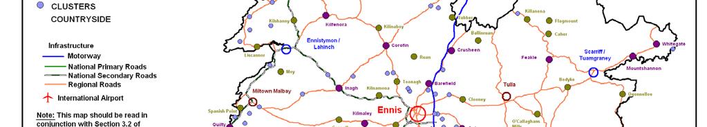
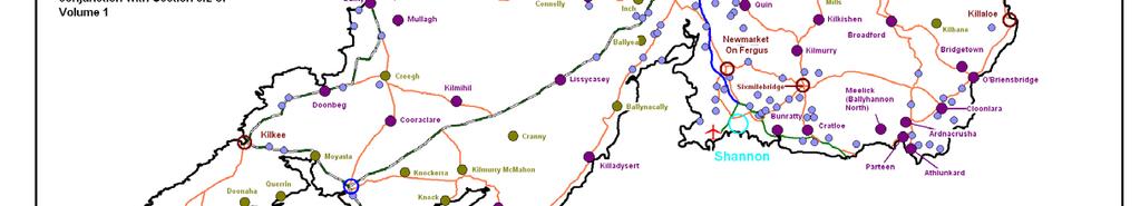
63
64 Summary of the Key Objectives of the Clare County Development Plan iii. Service Towns The Mid-West Regional Planning Guidelines identify three service towns in County Clare. The Development Plan reflects the designations and having regard to the local characteristics of these settlements namely Kilrush, Ennistymon/Lahinch and Scariff/Tuamgraney. They are been designated as service towns due to their role as important service centres and drivers of growth for their respective hinterlands. iv. Small Towns There are 9 small towns throughout the County identified in the Settlement hierarchy. They tend to have a population of approximately 1,000 persons or have the potential to grow to that level. They are of fundamental importance in offering services and facilities to their own populations and surrounding rural areas. They are also important employment and tourist centres. The strategy for the individual small towns is outlined in more detail in the Local Area Plans throughout the County. v. Large Villages Large villages generally accommodate a population of several hundred people and provide a reasonable range of services and facilities. Due to their existing and envisaged size the strategy for large villages is to provide for small scale well designed residential, commercial and community developments which have regard to the rural character of these settlements. A key priority is to retain community and social facilities within these villages, and the encouragement of indigenous enterprises and service provision. The strategy for the individual large villages is outlined in more detail in the Local Area Plans throughout the County. vi. Small Villages These are smaller settlements of up to approximately two hundred people with a rural character with some public services, e.g. a church, a school. The strategy for these settlements is that permitted residential growth will be small scale and on an incremental basis and must be reflective of the very rural nature of these settlements. The strategy for the individual small villages is outlined in more detail in the Local Area Plans throughout the County. vii. Clusters This is the smallest type of settlement in the hierarchy and the character of these areas reflects traditional clocháns of a loose collection of rural dwellings clustered around one or more focal points. Focal points may include existing rural houses around a cross road, or a community or social facility such as a shop, school, Church and/or post office. viii. Countryside The countryside are those parts of County Clare outside of recognised settlements and is therefore the lowest level of the settlement hierarchy in that its population is dispersed at the lowest density levels. The National Spatial Strategy and the Sustainable Rural Housing Guidelines recognise and support the long tradition of people living in the countryside and policies relating to this are included in the Plan. The strategic aims are: To ensure that Ennis Hub Town and Shannon Linked Gateway are drivers for the growth and development of both Clare and the Mid-West region. 49
65 Summary of the Key Objectives of the Clare County Development Plan To provide a strategic settlement strategy to manage population growth/targets and its respective housing needs and to achieve balanced development within the County. To promote sustainable urban development at a scale appropriate to the existing settlements and their location within the County, thus managing their development in an attractive, incremental, plan-led manner. To ensure that the specific needs of rural communities are identified and that policies are put in place to sustain and renew established rural communities : Joint Housing Strategy for Clare Local Authorities and Limerick City & County Councils Part V of the Planning and Development Act 2000 (as amended) places an onus on all Local Authorities to prepare a Housing Strategy for their areas. Clare County Council in conjunction with Limerick County Council and Limerick City Council has prepared a Joint Housing Strategy for This Housing Strategy replaces the Clare County Housing Strategy The Councils must ensure that sufficient and suitable land is zoned to meet the requirements of the Housing Strategy over the lifetime of the Development Plan. This Strategy is included in the Development Plan as Volume : Social Inclusion, Community, Education and Cultural Development The importance of providing for social and community infrastructure in towns, villages and rural areas, is an important element of the plan. Objectives to support the integration of planning and development of the County with the social, community and cultural requirements of the County and its population include: To promote, encourage and facilitate physical, social and cultural inclusion throughout the County and across all communities. To ensure that the principles of physical, social and cultural access and integration are central in all developments To promote and support improved social, community and cultural facilities and services throughout the County To encourage, promote and facilitate active and inclusive participation in physical, social and cultural activities : Employment, Economy and Enterprise In accordance with the overall plan Vision, the following Strategic Aims are considered critical to guide the economic development of the County through the Plan period 2011 to Ensure Ennis Hub Town and Shannon Linked Gateway continue to develop as drivers of economic growth in County Clare and the Mid-West region; Ensure the benefits of economic growth and prosperity are spread to all parts of the County; Maintain and promote County Clare s broad economic and employment base; Encourage, support and facilitate enterprise development at appropriate locations throughout the County; Encourage, support and facilitate Research, Technology, Development and Innovation as well as start-up business with high potential; Maintain, adapt and promote the industrial areas in Shannon as a driver of economic and industrial growth throughout the Mid-West Region; 50
66 Summary of the Key Objectives of the Clare County Development Plan Facilitate the diversification of the County s rural economy and encourage cottage industry and micro-enterprise; Facilitate social infrastructural investment for sustainable development : Retail Strategy This Retail Strategy for the Mid West Region has informed the preparation of this Clare County Development Plan and is subsequently added as Volume 6 to the Plan. In accordance with the overall Vision of the Plan, the following strategic aims are considered essential to the development of the County: To ensure that the retail needs of the County s residents are met in so far as is possible within County Clare To identify town centres that require the preparation of town centre strategies, in order to encourage and facilitate the enhancement and improvement of the town centres. To ensure that town and village centres be sufficiently pleasant, safe, accessible and vibrant to attract the public for shopping and social purposes. To examine mechanisms that could assist in the delivery of town centre sites as well as the redevelopment/rejuvenation of derelict sites for retail purposes. This will be revisited through the Local Area Plan process : Water Supply and Wastewater Services The provision of good quality water supply and effective wastewater disposal infrastructure are critical requirements for the future economic development, quality of life and sustainable growth of the County. In order to achieve this, the following strategic aims are considered essential: To protect, improve and conserve the County s water resources to meet the requirements of the Water Framework Directive. To facilitate the sustainable provision of necessary water supply and wastewater infrastructure. To facilitate the safe and controlled disposal of surface waters to approved receptors : Environment The natural environment is a valuable but vulnerable resource. In order to successfully manage the environment the following strategic aims are considered essential To achieve an integrated and sustainable approach to developing the County, and to strike a balance between development and the prudent management of the environment and natural resources. To encourage and promote the benefits of re-use and recycling of waste facilitates and to enable the provision of such facilities throughout the County. To achieve the highest possible standards of water supplies, wastewater treatment facilities and air quality. To enable the future sustainable development of the County by ensuring that future development is considered and managed against the risk of flooding. To minimise the level of flood risk to people, businesses, infrastructure and the environment. 51
67 Summary of the Key Objectives of the Clare County Development Plan : Energy and Communication The provision of high quality and reliable energy and communications infrastructure is essential for County Clare to attract and retain high-tech economic investment, maintain a high quality of life reduce our dependence on fossil fuels to meet our climate change targets. As part of the plan a Wind Energy Strategy was prepared which set out a plan-led approach to wind energy development in the County in terms of identifying strategic areas for wind energy development, it is added as Volume 5 of the Plan. Key objectives therefore include: To ensure security of energy supply throughout the County. To reduce County Clare s dependency on imported fuels and to provide alternative energy sources by harnessing the County s potential for renewable energy sources. To reduce County Clare s CO 2 emissions by achieving National, Regional and County targets. To promote and facilitate the provision and continued development of broadband and ICT infrastructure within the County to further enhance the social and economic development of Clare, particularly in the more peripheral areas of the County : Transport and Access The provision of a high quality transportation infrastructure in County Clare is a critical element to the County s socio-economic development. The integration of transport planning, accessibility and land use considerations is essential in order to provide for sustainable forms of transport. As such the following objectives are essential to achieve this: To provide a safe and efficient network of transport to serve the needs of the people, goods and services travelling to and within County Clare. To inform the settlement strategy and other land use considerations. To provide access for all. To promote and encourage the use of alternative sustainable modes of transport : Tourism The sustainable and successful development of the tourism industry is critical to the economy of County Clare and also to the wider Mid-West Region. The tourism industry contributes to the vitality and sustainability of a wide variety of local enterprises, particularly in rural areas, and tourism promotes an enhanced awareness of and positive appreciation of local traditions and ways of life. Strategic aims to maintain and further develop this industry include: To develop and enhance new and existing tourism products, attractions and tourism infrastructure To capitalise on the diversity of the County and promote appropriate and sustainable tourism-related development To develop strong, all year-round, high-quality integrated tourist products. To protect the environmental quality of the County on which much of the tourism quality is based To enhance physical access and maximise the potential of underdeveloped areas for tourism : Rural Development and Natural Resources The sustainable development of rural communities whilst maintaining their intrinsic qualities, diversifying the rural economy, developing natural resources 52
68 Summary of the Key Objectives of the Clare County Development Plan and maintaining vibrant rural communities is an essential part of the plan. Key aims to achieve this include: To reinforce the vitality and future of rural villages and settlements and to recognise the roles that they play in the wider social and economic context. To encourage and support the social and economic development of the rural parts of the County with a particular focus on the more disadvantaged areas. Existing local rural economies will continue to be supported and the diversification of local rural enterprises will be facilitated. To ensure that key assets of rural areas such as the natural and built environment are protected and enhanced, and rural areas with resources such as wind energy, water sources, and aggregates are sustainably developed. To harness the pride of place among rural communities and to assist rural communities to promote their cultural and national resources : Marine Resources and Coastal Zone Management County Clare has an extensive and varied coastline, network of waterways and lakes, which are a significant asset to the County. In order to manage and protect these assets the following objectives are required: To balance the protection of sensitive environmental areas with the utilisation of the natural resources in the area; To encourage improved access to the marine resources for both visitors and residents of the County; To promote the further development of the fishing and aquaculture industries; To protect the beaches and sand dunes of the County from degradation and damage; To manage coastal erosion and flooding in the County : Landscape The importance of landscape and visual amenity and the role of planning in its protection is recognised in the Planning and Development Act, 2000 (as amended), which requires that Development Plans include objectives for the preservation of the landscape, views and prospects and the amenities of places and features of natural beauty. To implement the Clare s Living Landscapes approach to landscape management and enhancement throughout the County. To encourage the utilisation of the Clare County Landscape Character Assessment in both the preparation and assessment of planning applications. To utilise the Clare Living Landscapes approach to ensure that development in the County takes place in the location/landscape deemed most appropriate. To sustain the natural and cultural heritage of the County : Natural Heritage County Clare is a County with a wealth of natural heritage and biodiversity that are of Local, National and International importance. In accordance with the overall Vision of the Plan, the following strategic aims are essential: To protect sites which have been designated for their ecological or environmental sensitivity from inappropriate development(s). To increase education and awareness of our natural heritage. 53
69 Summary of the Key Objectives of the Clare County Development Plan To promote sustainable development, in harmony with local biodiversity and, if possible, take steps to enhance the natural environment. To conserve and enhance the outstanding natural heritage and landscape of the County : Architectural and Archaeological Heritage Architectural Heritage represents the built environment of past centuries. It informs us about the lives of past generations and contributes to the form of present landscapes, both urban and rural. The structures can be of value as historic artefacts, as landmarks or as functioning buildings of today. In order to protect the legacy of historic buildings the following objectives are necessary: To protect and enhance the character of the built environment by means of the Record of Protected Structures and Architectural Conservation Areas To enhance present and future environments by protecting the Architectural Heritage of the County and successfully integrating new development. To protect the resource of archaeology in the County for both its intrinsic and tourism value : Design and Built Environment The built environment of Clare ranges from the historic towns of Ennis, Killaloe and Ennistymon, the new town of Shannon, to a variety of attractive smaller towns and villages. The built form also inhabits the countryside with an array of building types. Achieving a good quality built environment is essential for ensuring that County Clare is an attractive place to live, work and visit. The following objectives are therefore essential: To ensure that each structure or group of structures, whether in an urban or rural setting would enhance the environment. To ensure that structures or group of structures in urban areas are designed to create spaces between buildings which are attractive places for people to occupy. To ensure that structures or group of structures in rural areas are designed to protect and enhance the quality of the landscape particularly in the case of extensions to, or reuse of, vernacular buildings. To ensure that each structure or group of structures be designed and sited to maximise conservation of energy and resources and to facilitate flexible and sustainable use : Local Area Plans, Land Use and Zonings Key objectives for land-use zoning include: To ensure that adequate land is zoned to meet the needs of the population of the County. To ensure that sufficient land is zoned and serviced to provide for sustainable development and settlement growth throughout the County, in order to achieve the specified population targets of the Plan. To ensure that the land-use considerations in the Local Area Plans are set within the policy framework of the County Development Plan To ensure that social and physical infrastructure is developed in line with the growth of settlements in the County. To ensure that proposed developments are, where appropriate, directed to suitably zoned lands within designated settlement areas as provided for in the Plan. 54
70 Summary of the Key Objectives of the Clare County Development Plan : Environmental Protection Objectives The Environmental Objectives are derived from International, European and National policies on various aspects of the environment. The Environmental Objectives developed for this report are based on the environmental parameters as set out in Schedule 2B of the SEA Regulations. In addition to the settlement objectives as set out in the plan, the County Development Plan is subject to a number of high level National and International environmental protection policies and objectives, including those which have been identified and adopted as Strategic Environmental Objectives in Chapter 7. The Development Plan must be consistent with these objectives and implement them at County level. 4.9: Alternatives Chapter 8 of this report identifies, describes and evaluates different alternative scenarios for the future development of the Plan area, taking into account the relevant land use strategic actions, the Strategic Environmental Objectives (SEOs) identified in Chapter 7 of this report, as well as the geographical scope of the County. The evaluation of the alternatives results in the identification of potential impacts and leads to the emergence of a preferred alternative for the Clare County Development Plan
71 Consultation Chapter 5: Consultation 5.1: Introduction Under Article 13D of the SEA Regulations 2004 there is a requirement on Clare County Council to give notice to the Environment Authorities the scope of the Environmental Report. 13D(2)(c) of this Article indicates that: a submission or observation in relation to the scope and level of detail of the information to be included in the environmental report may be made to the planning authority within a specified period which shall be not less than 4 weeks from the date of the notice. Under Article 13A(4)(a) of the SEA Regulations 2004 the prescribed Environment Authorities are: the Environmental Protection Agency (EPA) the Minister for the Environment, Heritage and Local Government (DoEHLG), and the Minister for Communications, Energy and Natural Resources (DoCENR) Under Article 13F of the SEA Regulations 2004 there is a requirement to conduct transboundary consultation where there may be significant effects on another Member State. In this instance, counties bordering County Clare, i.e. Counties Galway, Limerick (and city), North Tipperary, and Kerry Local Authorities were consulted as part of the SEA process. Note: The Environmental Statement discusses how consultation and submissions have been taken into account during the preparation of the plan, and how environmental considerations have been integrated into the Plan. 5.2: Timeframe Review Process and Consultation Table 5.1 outlines a general timetable for the stages of the Review Process in the preparation of the Clare County Development Plan Table 5.1: General Timeframe for the Review Process Stage Date Commencement of Review and Preparation of DP, 25 rd February, 2009 ER & HDA. Closing Date for Public Consultation 24 th April, 2009 Submission of Manager s Report on Pre-Draft 16 th June, 2009 Consultation Process Elected Members to issue directions to the Manager regarding the preparation of the Draft DP, ER & HDA. Meettings held with the Environmental Authorities (EPA, NPWS) On or before 24 th August, nd September, th November, 2009 Preparation of a Pre-Draft Clare County Development Plan, the Environmental Report and Habitats Directive Assessment (following direction from elected members) by a multi-disciplinary team with representatives from various sections within the County Council Submission to Elected Members of Pre-Draft DP, ER & HDA. Latest date for amendments by resolution by Elected Members and thus deemed a Draft DP, ER & HDA. Commencement of public display and invitation of public submissions on Draft DP, ER & HDA. Closing date for public submissions on Draft DP< ER & HDA. 24 th August th November th November, th January, th January, th April,
72 Consultation Manager submitted report on submissions/observations received to the Members of the Planning Authority Members made amendments to Draft DP by resolution 4-week public display of Amendments to Draft DP, ER & HDA Manager submitted report on submissions/ observations received on the Amendments to Draft DP, ER & HDA to Members Managers Report should be read in conjunction with the HDA and Environmental Report, which identifies the likely significant effects on the environment of implementing the proposed CCDP. The Environmental Report must be taken account of before adopting the Plan. Adoption of CCDP , SEA Reports and HDA 25 th June th September th October 3 rd November th November th November January th January 2011 Implementation of CCDP , SEA Reports 7 th February 2011 (incl. Statement) and HDA 5.3: Consultation during the SEA Process Clare County Council consulted with the prescribed environmental authorities and other potentially interested bodies including transboundary consultations prior to and during the preparation of this Environmental Report. Clare County Council complied with the Planning and Development Act, 2000 (as amended) and the Planning & Development Regulations, 2006 in relation to informing the prescribed bodies for the purposes of preparing and making a Development Plan. A complete list of these Bodies and other interested Parties is illustrated in Table 5.2. In addition, internal consultation was carried out though the County Development Plan Cross Directorate Working Group and themed meetings with and between the Planning, Land Use and Transportation Department and other Council Departments. These meetings were on-going and central to the preparation of the Clare County Development Plan , the EPA Scoping Issues document and this Environmental Report. Elected Member workshops, public displays and workshops, and wide ranging consultation took place throughout the 2 year process. Initially a letter dated the 31 st October 2008 was sent to the prescribed environmental bodies and other interested parties (see Table 5.2) outlining Clare County Council s intention to undertake a SEA as part of the statutory review of the County Development Plan commencing in February Between theses dates an informal review was undertaken to collate SEA environmental parameter baseline data required for the Plan review under the following headings: Data collection: survey and analysis Informal consultation Identification of strategic and scoping issues Preliminary identification of alternatives, and Preliminary scoping of the Environmental Report Regarding the review of the exiting 2005 County Development Plan and the preparation of the Clare County Development Plan , an Issues paper identifying planning and environmental issues that the Draft Plan could address was prepared for public consultation and comment. The Issues Paper booklet Have Your Say in the Future of County Clare was made available in all libraries and offices of Clare Local Authority and also on the Local Authority website. 57
73 Consultation Table 5.2: Informal Review Notification sent to Prescribed Environmental Bodies and other Interested Parties Aer Rianta An Bord Pleanála An Taisce Bord Gáis Bus Eireann Inland Fisheries Ireland Clare County Enterprise Board Coillte Teoranta Dept. for Trade, Enterprise and Employment Dept. for Arts, Sports and Tourism Dept. of Agricultural, Fisheries and Food Dept. of Education and Science Dept. of ECNR (Minister) Dept. of ECNR (Coordination Unit, Cavan) Dept. of ECNR (Exploration and Mining Division) Dept. of EHLG (Development Applications Unit) Dept. of EHLG (Spatial Policy Section) Dept. of EHLG (Western Division, NPWS) Eircom Environmental Protection Agency ESB Fáilte Ireland Forás Galway County Council Health and Safety Executive Health Service Executive Iarnród Eireann Irish Concrete Federation Kerry County Council Limerick City Council Limerick County Council Mid-West Regional Authority National Road Authority Office of Public Works Safety and Aviation Standards School of Spatial Planning, DIT Shannon Development Shannon Regional Fisheries Board The Heritage Council Tipperary N.R. County Council This Issues Paper set out what were considered the main development issues facing County Clare between , while acknowledging this list was non exhaustive. The issues paper welcomed public debate on what the broad planning, development and environmental matters should be copies of this booklet were circulated to the Elected Members, the public, community groups, Statutory, State and Government bodies. Appendix C of the Manager s report to Members on submissions arising from the Pre-draft Consultation Stage (16 th June 2009) lists the persons, bodies and public access points which were furnished with copies of the Issues booklet. 58
74 Consultation As part of this process a series of public consultation events were held throughout the County to gather the views of local communities, organisations and other interest groups, which were advertised in the Clare Champion, Clare People, Clare Courier, County Express, and on Clare FM radio station. A series of Public Information Workshops, as set out below in Table 5.3, were also held during the consultation period to which all members of the public and other interested groups were invited. The aim of these workshops was to raise awareness of the Review, the role of the public in the preparation of the new Plan, and to encourage submissions regarding their views on what should be included in the Draft Clare County Development Plan Section 5 of the Manager s report to Members on submissions arising from the Pre-draft Consultation Stage (16 th June 2009) summarises the issues raised. Table 5.3: Public Information Workshop Details Venue Date Kilrush Community Centre: 10 th March 2009 Ennistymon Community Centre 11 th March 2009 Oakwood Arms Hotel, Shannon 18 th March 2009 Ballyvaughan Community Hall 23 rd March 2009 Scariff G.A.A. Hall 24 th March 2009 Carrigaholt/Kilbaha area 26 th March 2009 Westbury/Parteen area 31 st March 2009 Áras Contae an Chláir, Ennis 1 st April 2009 Submissions or observations regarding the review of the existing 2005 Clare County Development Plan and preparation of the Clare County Development Plan together with the SEA and HDA processes could be made in writing or by to Clare County Council between Friday 27 th February 2009 and Friday 24 th April, In total 72 formal written submissions were received by the Planning Authority within the statutory time period. Table 5.4 summarises the 72 submissions received together with comments and recommendations from the Elected Members 14. Following consideration of the 72 written submissions and the outcome of the public workshops a Manager s report was submitted to the Elected Members on the 16 th June Subsequently, a number of workshops with the Elected Members were carried out (a number of workshops with the Elected Members were carried out throughout the review process). The main issues raised by the Elected Members at the workshops were: Settlement Strategy Social Inclusion Energy and Telecommunications Employment and Economic Development Retail Planning Wastewater Treatment and Services Roadway Development Tourism Development Furthermore, a meeting was held with the EPA to outline the SEA Scoping Issues which determined the baseline environmental parameter data and issues to be considered in the Environmental Report. Also, a meeting was held with the National Parks and Wildlife Service (NPWS) to outline both the SEA and HDA considerations. Following consideration of the Manager s Report (16 th June 2009), the Elected Members issued direction to the Manager regarding the preparation of the Pre- 14 Also see the Environmental Statement for details 59
75 Consultation Table 5.4: Pre Draft Submissions for the Draft Clare County Development Plan Sub Person/Organisation Summary of Submission Comments Recommendation to Members 001 Shannon Broadband Ltd, Shannon Development Draft CDP should refer to urgent need for the physical broadband infrastructure in Shannon and Ennis. CDP should mandate use of new broadband planning guidelines currently under development by Shannon Development. 002 Jim Martin, Miltown Malbay Draft CDP should encourage provision of micro generation wind turbines for reasons of efficiency to users. 003 Jackie Whelan, Chairman, West Clare Railway Ltd. Draft CDP should support aims of WCR to restore the line between Kilrush and Kilkee as a major tourist attraction. (See also 011) 004 Cllr Christy Curtin Draft CDP should support the preparation of a database for floodplains, storm water systems and watercourses throughout the County. 005 Irish Concrete Federation Submission concentrates on access to extractive industry resources. Suggests policy statement for inclusion in draft CDP. Need for longer term permissions. Need to tighten controls on unauthorised operators. Need to allow extraction below water table. Need to map resources of County. Recycle construction waste to extractive industry. 006 Dept of Education & Science Information provided relating to size and space standards for new schools. References to recent DoEHLG and DES guidance on site suitability. 007 John Cleary, The Hand Cross As owner of a substantial area of land around Sliabh Calláin, considers that the area is suitable for the exploitation of wind energy. 008 Seósamh Mac Ionnrachtaigh Coiste Forbartha Gaeltachta an Chláir Cill Mhíchíl 009 George Brew Kilrush Advocates the establishment of Gaeltacht status for all or part of Clare. This should be recognised in draft CDP. Settlement location policy should make provision for town dwellers with family land outside town to build a house for their own occupation. Agree with submission. Section on broadband communications in existing CDP to be updated to take account of the submission. The Planning and Development Regulations 2007 increased the range of micro- renewable energy installations exempt from planning permission. References to be incorporated into draft Plan. The WCR Co. have prepared a detailed development programme for the restoration of the line between Kilrush and Kilkee and this is to be commended as a major tourist attraction for the area. The surviving WCR steam locomotive is being restored to working order and there are plans to develop museum facilities. The OPW have mapped all areas of flood risk in the 28 counties. In September 2008 the DoEHLG published draft guidelines on flood risk management and these give guidance on how this issue should be addressed in the preparation of development plans. Some of the issues raised in the submission are covered by existing legislation and CDP policies. Policy in respect of recycling construction waste is supported. Appropriate references will be made in the relevant section of the draft CDP. It is considered more appropriate that this submission be considered in the preparation of the new Wind Energy Strategy. This will inform the draft Plan. The responsibility for establishing new Gaeltachtaí lies with the Minister for Community, Rural and Gaeltacht Affairs and as such the submission is outside the scope of the draft Plan. Unless the family land is in a structurally weak area any such policy would be contrary to the Sustainable Issues raised should be taken into consideration in the preparation of the draft Plan. Issues raised should be taken into consideration in the preparation of the draft Plan. Draft CDP should contain a specific policy safeguarding the route of the line between Kilrush and Kilkee and supporting proposals to restore the line to working order. Submission noted. Issues raised should where appropriate be taken into consideration in the preparation of the draft Plan. Appropriate references to standards for new schools should be included in the draft Plan. Submission noted. Submission noted. No action. Submission noted. No action. 60
76 Consultation 010 Jackie Whelan Tullagower Quarries Ltd. Kilrush 011 Jackie Whelan, West Clare Railway Ltd. 012 Fintan Moloney Bodyke Clare Recycling and Manufacturing is a wholly owned subsidiary of TQL. Draft CDP should recognise the importance of waste recycling. Expands on submission 003 to suggest promoting the bogland area between Kilkee and Cooraclare as an attraction for sustainable tourism development. Process of obtaining permission for housing development in villages is too long. Suggests improvements to design of houses in the countryside. The headquarters of the proposed Burren Geopark should be located at the Spa Wells Centre. rural Housing Guidelines. The WCR Co. has prepared a detailed development programme for the restoration of the line between Kilrush and Kilkee and this is to be commended as a potential major tourist attraction for the area. The surviving WCR steam locomotive is being restored to working order and there are plans to develop museum facilities. The promotion of the adjacent bogland as a complementary visitor attraction is to be welcomed. There are no proposals to amend the Rural House Design Guide. 013 Peter Curtin on behalf of Lisdoonvarna Fáilte. This is a site specific issue which lies outside the scope of the CDP review. 014 Ennis Chamber Submission consists of 2 documents: These refer to issues that relate to the E&E Issues for Ennis (undated) Development Plan area and are outside the remit of Submission to E&E Draft Plan the CDP review. 015 Dept. of Education and Science Similar to 006 but with additional references to projected pupil numbers Discussions are ongoing with the Department to for high and low growth scenarios. ensure that the Code of Practice for Planning Authorities and the Provision of Schools is followed. 016 David Johnson Investigate the feasibility of a coastal cycle route in Clare. The issue of cycle routes will be addressed in the Tourism and Recreation chapters of the draft Plan. 017 NRA Draws attention to NRA policies in relation to the impact of development on interchanges, protecting route options for new or improved road schemes (N85), access to national roads, services areas (none currently proposed in Clare) and exceptional circumstances when major developments may be allowed direct access. 018 McCarthy Keville O Sullivan on behalf of Coillte Teoranta Requests that the draft CDP ensures: protection of the safety, carrying capacity and efficiency of existing and future national roads is maintained integrated approach to land use and transportation so that local traffic generated by developments is catered for primarily within the framework of the local road network. Requests that the draft CDP gives a clear commitment to the positive consideration of high quality tourism and outdoor recreation proposals based on natural assets and features, with a general presumption in favour of such developments that offer significant economic benefits for the area. The policies of the NRA will be taken into account when in the preparation of the draft Plan. It is considered that there should be an exception to the ban on new accesses to National Secondary Routes in circumstances where a new dwelling is required on family land and where there is no existing access. Such cases occur rarely and, provided the relevant sight distances can be achieved, it is considered that such development would not have a material impact on traffic safety. The importance of enhancing the tourism product in the current economic climate is recognised and will be given due weight when preparing the draft Plan. Draft CDP should contain a specific policy safeguarding the route of the line between Kilrush and Kilkee and supporting proposals to restore the line to working order. Submission noted. No action. Submission noted. No action. Submission noted. No action. Appropriate references to future schools requirements should be included in the draft Plan. The issue raised should be considered in the preparation of the draft Plan. The policies of the NRA should be taken into account in the preparation of the draft Plan. The exception referred to should remain in the CDP. Issues raised should be taken into consideration in the preparation of the draft Plan. 019 Department of Transport Draws attention to Guidelines on public safety zones at state airports Submission noted. Submission noted. 61
77 Consultation currently being prepared by the DoEHLG. 020 An Taisce Encourage eco-tourism. Protect old and new walkways. Place services before development. Impact of climate change and future fuel shortages on travel to work distances. Submission also refers to flood risk, retentions and inadequate enforcement. 021 Donna Smith, Raises a number of planning, environment and signposting matters. Flagmount 022 Siobhán Mulcahy FRIAI Tulla Raises the following issues of relevance to the CDP: Public transport, home working, housing development size, infrastructure, built heritage, one off houses, design. 023 EirGrid Concerned that the CDP should support the provision of new high voltage infrastructure. Suggests new policy wording: The development of secure and reliable electricity infrastructure is recognised as a key factor for supporting economic development and attracting investment to the area. It is the policy of the Planning Authority to support the infrastructural renewal and development of electricity networks in the region. 024 Iarnród Éireann Priorities for investment in Clare are: provide additional capacity need to serve an expanding commuter belt need to address bottlenecks in the system upgrade facilities in line with customer expectations Need to encourage land use policies that support investment in public transport to ensure maximum economic, social and environmental benefit. Integration of land use and transport a key issue. 025 Paddy Cusack Lisdoonvarna Submission relates to specific proposals within the settlement boundary of Lisdoonvarna, including new permanent housing in the town centre and reserving the Council owned land at Rooska as a land bank for employment generating uses, sheltered housing and serviced sites. 026 Limerick Regeneration Agencies Whilst outside the functional area of Clare, the Northside regeneration areas of Moyross and St. Mary s lie adjacent to the County boundary. The Agencies wish to ensure that there is no conflict between their policies and plans and those of the County Council and have identified the following strategic planning issues that are relevant to both bodies: housing/settlement The submission is noted and insofar as is practical these issues will be addressed in the preparation of the draft Plan. Most of the points raised are outside the remit of the CDP and are operational issues CDP should have as an objective the desirability of restricting highway signage in vulnerable landscape areas, architectural conservation areas and on scenic routes. The submission is noted and insofar as is practical these issues will be addressed in the preparation of the draft Plan. The suggested policy is similar to the wording of para in the current Plan. The submission refers to the progress on the Western Rail Corridor, including proposed major improvements at Limerick station and passing loop between Ennis and Limerick. There is however no reference to the land zoned at two locations in the Ennis and Environs Plan area and at Crusheen for new stations and to the statement in the existing CDP for stations to serve Shannon, Cratloe and Quin/Newmarket. No reference to the Shannon rail link. The North Clare Local Area is due to be reviewed by February 2011 and it is more appropriate that a submission of this nature is considered as part of the review. The proposals of the Agencies should be recognised and supported in the appropriate chapters in the draft Plan. No action. Issues raised where appropriate should be considered in the preparation of the draft Plan. Draft CDP should have an objective that roadside signage on scenic routes, in vulnerable landscape areas and architectural conservation areas should be minimised without compromising traffic safety. Issues raised where appropriate should be considered in the preparation of the draft Plan. The suggested policy is supported and should appear in the draft Plan. The Planning Authority supports the current and proposed improvements between Limerick and Galway. Draft Plan should contain policies supporting Shannon rail link and additional stations. Submission noted. No action. Issues raised should be considered in the appropriate chapters of the draft Plan. 62
78 Consultation transport planning employment facilitation retail planning amenities 027 Brendan McGrath and Associates a) Include a policy to enter into discussions with Limerick City and Limerick County regarding the preparation of a Limerick City and Environs Development Plan and including the Parteen villages. b) Include a policy for an eco-village on the line of the Ennis to Limerick railway. c) Develop a new physical strategy for the Burren. 028 McHale Plant Sales Birdhill 029 McHale Plant Sales Birdhill 030 McHale Plant Sales Birdhill 031 James Whelan Killaloe 032 Michael Courtney Killaloe 033 Brian Whelan Killaloe Zone 28 acres at Killaloe for mixed uses, integrated tourism and residential. Zone 15 acres at Killaloe for integrated tourism. Zone 14 acres at Killaloe for residential. Zone 9 acres at Ardclooney, Killaloe as a residential cluster. Zone 18 acres at Ballyheefy, Killaloe for integrated tourism. Zone 38 acres at Ardclooney, Killaloe for integrated tourism. a) Unlike Limerick County, that part of suburban Limerick lying in Clare is comparatively small and largely comprises the Westbury area, which has developed in a sustainable manner and poses no threat to the vitality of Limerick City centre. Any suggestions for a joint development plan should await the outcome of the proposals to extend the city boundary. b) It is considered that Clare does not have the critical mass for the establishment of a new village. The current settlement strategy is well established and would be undermined by the addition of a new settlement tier. c) It is considered that the existing agencies involved in the management of the Burren provide sufficient physical protection for the area. The opportunity to enhance this protection will arise if the area gains world heritage status. The East Clare Local Area Plan is due to be reviewed by February 2011 and it is more appropriate that a submission of this nature is considered as part of the review. The East Clare Local Area Plan is due to be reviewed by February 2011 and it is more appropriate that a submission of this nature is considered as part of the review. The East Clare Local Area Plan is due to be reviewed by February 2011 and it is more appropriate that a submission of this nature is considered as part of the review. The East Clare Local Area Plan is due to be reviewed by February 2011 and it is more appropriate that a submission of this nature is considered as part of the review. The East Clare Local Area Plan is due to be reviewed by February 2011 and it is more appropriate that a submission of this nature is considered as part of the review. The East Clare Local Area Plan is due to be reviewed by February 2011 and it is more Draft Plan should not consider the preparation of a joint development Plan for the greater Limerick area. Draft Plan should not consider the establishment of a new village. In the event of the Burren gaining world heritage status during the lifetime of the Plan, the draft Plan should include appropriate policies enhancing the physical protection of the area. Submission noted. No action. Submission noted. No action. Submission noted. No action. Submission noted. No action. Submission noted. No action. Submission noted. No action. 63
79 Consultation 034 Brian Cullen Killaloe 035 HRA Planning on behalf of Brian Whelan 036 Doonbeg Community Development Ltd. Zone 40 acres at Killaloe for residential. Zone lands at Ardclooney, Killaloe for integrated tourism. The submission is mainly concerned with site specific and local issues in the Doonbeg area but also deals with the scale and nature of recent development in Doonbeg. 037 Cyril O Reilly Design Ltd. a) Raises issues of definitions and interpretation in relation to rural housing policies in the current CDP. b) Draft Plan should have structurally weak and urban generated designations only. c) Policy relating to replacement of derelict dwellings should be clarified. d) Raises issues of residential design. 038 Andrew Clancy Moy Beg Lahinch Extend structurally weak area to include area around Moy church and school. 039 Shannon Foynes Port Co. Identifies 15 potential sites for deepwater port areas on the Clare side of the estuary. 040 Doonbeg Business and Marketing Group 041 Centre for Environmental Living and Training (CELT) Scariff 042 John Spain Associates on behalf of Aldi Stores N68 from Ennis needs major upgrade Serviced sites needed in settlements Tourism potential of W. Clare should be developed Broadband in W. Clare needs to be improved Better bus services needed The submission provides a detailed response to each of the questions raised in the Issues Paper and reflects the principles of sustainability that CELT encourages. CDP should recognise important role of discount foodstores and contain specific policies and objectives. CDP should recognise appropriateness of permitting discount foodstores in neighbourhood centres. Definition of discount foodstore should be included in CDP. appropriate that a submission of this nature is considered as part of the review. The East Clare Local Area Plan is due to be reviewed by February 2011 and it is more appropriate that a submission of this nature is considered as part of the review. The East Clare Local Area Plan is due to be reviewed by February 2011 and it is more appropriate that a submission of the nature is considered as part of the review. Doonbeg is ranked as a large village in the current CDP where controlled settlement growth is permitted in principle. The status of Doonbeg and other settlements will be reassessed as part of the review. Points a) b) and c) will be re-examined in the preparation of the draft Plan. A review of designations will be undertaken during the preparation of the draft Plan. A similar submission was made in respect of the West Clare Local Area Plan. (Completion of report and recommendation awaiting adoption of LAP) The submission focuses on the exploitation of West Clare s tourism potential and its importance to the local economy and the need to improve transport and telecommunications to the area. The points raised will be considered in the appropriate chapters when preparing the draft Plan. This is a wide ranging and detailed submission and refers to policies and issues that are in the current CDP. These will be addressed in the preparation of the draft Plan. Aldi and Lidl are the two main discount foodstores operating in Ireland and sell a similar range of goods. Until now their site requirements have usually been for a simple shed structure with a dedicated car park, although a recent store in Submission noted. No action. Submission noted. No action. Settlement hierarchy should be reassessed in the preparation of the draft Plan. Issues of rural settlement policy and derelict dwellings should be considered in the preparation of the draft Plan. A review of rural settlement policy designations should be considered in the preparation of the draft Plan. Issues raised where appropriate should be considered in the preparation of the draft Plan. Issues raised should be taken into consideration where appropriate in the preparation of the draft Plan. The new retail planning guidelines will inform the Plan and will be taken into account in the preparation of retail policies. 64
80 Consultation 043 Carrigaholt Development Association Vision for the economic development of Loop Head peninsular is dependent on the promotion of tourism, added value to local family farms and development of local small businesses. 044 Clare Biodiversity Ltd. The submission provides a detailed response to the questions raised in the Issues Paper and covers similar issues that were dealt with in 041. (comments from Congella) 045 Miriam Hynes Identifies parcels of land and requests that they be included in the Bellharbour Bellharbour settlement boundary. 046 Shannon Chamber Submission is based on the responses to a survey of the Chamber s members. Issues raised include: Improving the physical attractiveness of the town. Shannon Town Centre Masterplan. Housing self build sites needed. Long term commitment to Shannon rail link needed. Continued improvement to national road network needed. Commercial development similar to Kildare Village Outlet should be considered for Shannon. Reliable broadband service essential. Sea front areas of towns and villages need upgrading. Clare s potential for activity holidays needs to be further exploited. Multiplicity of agencies offering business advice is confusing. More attention should be directed at advice to start up business. Issues in respect of renewable energy and climate change. 047 Shane Burke, Leagard South Reduce speed limit on N67 south of Miltown. (Covering submission for 048 to 054) Oranmore is on the ground floor of a mixed use development. There are two discount stores in Ennis and one in Shannon. The potential for further discount foodstores in the CDP area is limited and probably confined to Shannon. New retail planning guidelines for the Mid West Region are currently being prepared and will inform the draft Plan. The peninsular has a distinct character with its rugged coastline and ladder field systems and deserves to be better known as a visitor destination. The issues of strengthening tourism and local enterprise will be addressed in the preparation of the draft Plan. The submission refers to policies and issues that are in the current CDP. These will be addressed in the preparation of the draft Plan. The submission is outside the remit of the CDP. Some of the issues raised relate to the South Clare LAP or are operational matters. Other issues will be considered during the preparation of the draft Plan. The concept of a village outlet in Shannon is to be welcomed. Outside remit of CDP. Referred to T&I for attention. Issues raised should be taken into consideration where appropriate in the preparation of the draft Plan. Issues raised should be taken into consideration where appropriate in the preparation of the draft Plan. Submission noted. No action. Issues raised should be taken into consideration where appropriate in the preparation of the draft Plan. Submission noted. 048 Shane Burke, Leagard South As above As above Submission noted. 049 Mary Burke, Leagard South As above As above Submission noted. 050 Hallam Studdert, Leagard South As above As above Submission noted. 051 Ann & Patrick Kenneelly, Leagard As above As above Submission noted. South 052 Patrick J Egan, Leagard South As above As above Submission noted 053 Dominic Murrihy, Spanish Point As above As above Submission noted 054 Michael Lyons, Leagard South As above As above Submission noted 65
81 Consultation 055 Michael Lynch Chairman Clare IFA 056 Eamonn Dunne on behalf of Padraig Moroney, Broadford Policies in the draft Plan should be positive towards farming. Conservation and development of the agricultural sector one of the best ways forward for the County. Access by hill walkers should be regulated by a structured system of consultation. a) Structurally weak designation should take precedence over vulnerable landscape. b) Definition of housing need should be specifically defined. 057 Cllr Tony O Brien Specific zoning category for self build sites. Housing need should be clearly defined. Local Rural Person should be replaced by Local Person, defined as one applying for a residential permission within a 10km radius of where they live, whether urban or rural. Visual considerations within urban areas should be clearly defined. All heritage towns should have a master plan. CDP should recognise the importance of the Shannon to the economy and future development of Clare. 058 Terence Corry Kildysert 059 Tom Varley on behalf of the Aughty Development Group 060 Andy Curry Liscannor No necessity for local area plans. Reuse of derelict houses should be encouraged. Water quality in Clare not adequately protected. Cahercon Pier should be again proposed as a protected structure. Issues of declaring legal interests issues where lands proposed for zoning. CDP should identify the potential of the Slieve Aughty area for the promotion of its natural and cultural assets. The opportunity exists for a creative collaboration between Clare and Galway for the area as a whole. Following issues regarding Liscannor area: inadequate waste water treatment, upgrade road from Ennis to Cliffs of Moher, extend broadband, coastal erosion, development of harbour and exploit the potential of the town s connection with the inventor of the submarine. 061 Whelan Group Issues with Cahercon Pier. Suggests policies for the recovery and recycling of construction and It is considered that policies in respect of agriculture in the current CDP are broadly relevant today and these should be reflected in the draft Plan with updating as necessary. The structurally weak and vulnerable landscape designation areas are being re-examined as part of the review. Where the two coincide the vulnerable landscape policy will take precedence. It is intended that the review will clarify and simplify terms and phrases. Zoning issues are considerations for LAPs. As a policy issue reference to self build sites can be included in the draft Plan. It is intended to include clearly understood definitions of words and phrases in the new Plan. Such a definition would not be in conformity with the Sustainable Rural Guidelines. ACAs have clearly defined boundaries. Heritage Towns are members of a private organisation. Historic towns are officially recognised zones of archaeology. There are 5 in the Plan area. And 19 ACAs. 3 village design statements are being prepared. It is considered that the preparation of master plans is resource intensive and that ACA policies are sufficiently robust in themselves. The importance of the River Shannon and Shannon will continue to be recognised in the CDP. The draft Plan will address the issue of wording of policies relating to derelict buildings so that they can be more easily understood. (Cahercon Pier to await WCLAP) It is considered that the Tourism chapter refers to the potential of the Slieve Aughty area and its natural and wildlife assets and distinctive character on the Clare Galway border. Some of the issues raised relate to operational matters. Commitment to continued improvement to road and broadband networks will be referred to in the draft Plan. Issues raised should be taken into consideration in the preparation of the draft Plan. The issue of rural housing policy should be considered in the preparation of the draft Plan. The issues raised in a, b and f should be taken into consideration in the preparation of the draft Plan. Issues raised should where appropriate be taken into consideration in the preparation of the draft Plan. Draft Plan should include references to Slieve Aughty area. Issues raised where appropriate should be taken into consideration in the preparation of the draft Plan. 66
82 Consultation 062 Development Applications Unit DoEHLG demolition waste, and alternative sources of energy. Detailed submission with recommendations in respect of nature conservation, archaeological and architectural heritage issues. 063 Construction Industry Federation A detailed submission, it reiterates the views of the CIF, many of which reflect the statutory obligations of a planning authority in preparing a development plan and its role in coordinating development and social and physical infrastructure considerations. A fuller submission will be made to the draft Plan. 064 Roger Garland on behalf of Keep Ireland Open 065 Town and Country Resources Ltd on behalf of Doonbeg Golf Club Ltd 066 Mary Lynch on behalf of University of Limerick Detailed submission with suggestions and recommendations in respect of rights of way, walking routes and access to open land. a) CDP should promote sustainable tourism and the development of tourist facilities. b) CDP should encourage tourist infrastructure. c) CDP should include policy provision for the consolidation and further development of established tourism assets in the County. The submission contains a detailed description of the facilities at UL and their future expansion. UL would welcome the detailed provisions in the South Clare LAP being reflected strategically in the CDP and in this context the wording for a policy framework statement is suggested. 067 Dublin Airport Authority Provides an overview of the facilities at Shannon Airport and plans for their continued development. The importance of continued improvement to road and rail infrastructure to the airport from the wider region is stressed. A more detailed submission will be made to the draft Plan. 068 Cunnane Stratton Reynolds on behalf of Zinc Properties Ltd 069 Cunnane Stratton Reynolds on behalf of Greenband Investments and Sean Halpin Include strategic objective in CDP recognising the benefits of development of a sustainable recycling and renewable energy ecobusiness park. The former Burlington site at Gillogue is referred to in this respect. Update current CDP to take account of advances in technology in sustainable recycling and energy production. Shannon is deficient in bulky goods provision. Requests that the CDP acknowledges the need to broaden the retailing base of the town, particularly in the area of bulky goods. A new County Housing Strategy will be prepared in parallel with the draft Plan and this will take into account the new population targets and forecasts from the Mid West Regional Authority, DoEHLG and the CSO. All data will be updated in order to ensure the current economic and housing market situation is taken into account. While the submission focuses on the Doonbeg hotel and golf complex and its importance to the economy and employment locally, the issues raised are relevant to the County as a whole. The development of sustainable tourism is vital to Clare at a time when other sources of employment are set to remain scarce for some time and the submission is to be welcomed. The South Clare LAP 2009 contains a policy supporting the continued expansion of UL. This policy will be strengthened in the draft Plan in a strategic context. The draft Plan will emphasise the importance of continued long term commitment to improved transport infrastructure serving the airport. The South Clare LAP 2009 identifies the Burlington site as a Proposal Site with a list of appropriate uses. Any proposal to develop this site must be accompanied by a masterplan. There is retail leakage, including bulky goods shopping, to Ennis and Limerick. The South Clare LAP 2009 identifies the proposed extension to Shannon town centre as an appropriate location for this type of development. A planning application for a mixed use development is currently before the The issues raised should be taken into account in the preparation of the draft Plan and Housing Strategy. The issues raised should where appropriate be taken into consideration in the preparation of the draft Plan. The policy framework in the South Clare LAP should be transposed into the draft Plan and strengthened to reflect the importance of UL to the County and the wider region. The draft Plan should emphasise the importance of continued long term commitment to improved transport infrastructure serving the airport. Submission noted. 67
83 Consultation 070 Pat Sweeney Mountshannon 071 Susan Bellow Lahinch 072 Community & Enterprise On behalf of Clare County Development Board Critical of scale of development in settlements over last 10 years. Issues in respect of the following: Light pollution from street lamps. Surface water drainage and flooding. Encourage cycling and walking. Building design and public open spaces. Vulnerable landscapes. ID. no. of key strategic areas for the future CCDB are delivering a no. of strategic documents that the CCDP must take account of Council. The forthcoming Planning and Development Bill will introduce restrictions on the amount of land that can be zoned for housing development in development plans and LAPs. The East Clare LAP is due to be reviewed by February The submission relates mainly to operational matters. The risk of flooding in new developments is being addressed by following the principles of sustainable urban drainage. Work of CCDB acknowledged and will inform policies and objectives Submission noted. Submission noted. 68
84 Consultation Draft Development Plan (see Table 5.5). The Elected Members received this Pre- Draft Plan for their consideration on 16 th November Between 19 th Table 5.5: Elected Members Directions Issued and the Manager s Recommendations Summary of Direction Issued Policy to allow rural house if land owned for more than 10 years. Extension of definition of LRP to define local area within 20 miles of site Policy to facilitate rural house for persons with physical and intellectual disabilities where rural environment essential Policy to facilitate development of small scale rural enterprise in all parts of CDP area Critique of 2005 CDP. Enclosed minutes of 8 meetings of Kilrush EA members in 3/06, 4/06 and 5/06 Senior Planner to meet applicants on site following refusal and intention to reapply Engineer s report on sight distances be accepted Townlands where population is static or declining be designated low pressure Designations, inc. vv, to be assessed on townland basis by review cttee of members and planners LRP defined as one born within 10 miles of site/same status to parents, children/same status to one living in same area for any 5 years of life/parishioner qualify as LRP LRP by association working in area, involved in sporting, cultural or business life of parish Housing refusals to go on extension of time and discussed by review committee Rural houses under 2,500 sq ft be allowed without restriction on design except extremely undesirable designs to go before review committee Pre planning meetings to be recorded Site assessments passed by members of panel be accepted Housing applicant be notified if application is due for grant subject to subject to successful outcome of costly procedures e.g. archaeological digs Planning decisions made known 4 days prior to due date Parents and children of landowners also nieces and nephews qualify for LRP status Internal reports in withdrawn applications be available to members Site meetings prior to planning application Robust critique of 2005 CDP. Return to format of 1999 CDP. Includes a summary of Kilrush EA members meetings in 2006 Request Manager get legal advice on assessment of personal circumstances of applicants Have concerns about groundwater quality in parts of County. SRBMP will impact on development proposals in plan area Request CCC develop best practice broadband strategy. Plan should include connection targets. Plan to take account of findings of trials by SEI soon to begin on effectiveness of micro wind turbines Identify and preserve route of WCR where possible Refer to work by NUI Maynooth s research unit on climate change Detailed request from Keep Ireland Open on several issues to be in plan. Effectively a supplementary pre draft submission submitted Outreach services from UL and NUIG should be objectives in plan plan to refer to recovering materials from end of life vehicles Industrial and commercial development to be provided not to create shadow fallout. Town and village centres focus for commercial 69
85 Consultation November 2009 and 6 th January 2010 the members considered the Pre-Draft Development Plan before making amendments to the Pre-Draft (by resolution) at the January 2010 Council Meeting The Draft Clare County Development Plan , consisting of five volumes, was advertised in the local newspapers and placed on public display for a period of 10 weeks from 25 th January, 2010 to 6 th April, In complying with the SEA Directive (2001/42/EC), the Planning and Development (Strategic Environmental Assessment) Regulations 2004, and the Habitats Directive (92/43/EEC) information on likely significant effects on the environment of implementing the proposed Development Plan were prepared in the form of a Draft SEA Environmental Report and Draft Habitat Directive Assessment in conjunction with the Draft Clare County Development Plan During this public consultation period, copies of the Draft Plan, Environmental Report and Habitats Directive Assessment were submitted to the Elected Members, the Minister for Environment Heritage and Local Government, An Bord Pleanála, the prescribed Environmental Authorities, adjoining Local Authorities and other statutory bodies in accordance with Section 12(1)(a) of the Planning and Development 2000 (as amended). The Plan and associated Environmental documents were also made available to the public in hard copy format, CD format and electronic format on Clare County Council s website. Following this period of public consultation a Manager s Report (25 th June 2010) summarising 106 formal written submissions received within the statutory period was presented to the Elected Members for their consideration taking account of the proper planning and sustainable development of the area, the statutory obligations of any Local Authority in the area, and any relevant policies or objectives of the Government or of any Minister of the Government. Under Section 12(5) of the Planning and Development Act 2000 (as amended), following receipt of this document, the Members were required to consider the Draft Development Plan, Environmental Reports, and the Manager s Report. After consideration of all the documents, the Members, by resolution, materially amended the Draft Clare County Development Plan by resolution at the (13 th ) September 2010 Council Meeting, in accordance with the provisions of Section 12(6) of the Planning and Development Act 2000 (as amended). These material alterations were required to have regard to and be informed by the SEA and HDA processes. These proposed material amendments, consisting of seven volumes, including the SEA Environmental Report and Appropriate Assessment Screening report went on public display in October The process commenced with a notice in the local newspapers and the subsequent commencement of 4 weeks public consultation, from the 5 th October rd November 2010, having regard to the provisions of Section 12(7) of the Planning and Development Act 2000 (as amended) and the Planning and Development SEA Regulations and Habitats Directive. In total, 111 submissions were received within the statutory period. Under Section 12(8) of the Planning and Development Act 2000 (as amended) a Manager s Report (26 th November 2010) was prepared on the submissions and observations received and submitted to the Elected Members for consideration. This report related to the submissions to the proposed amendments to the Draft Clare County Development Plan, the associated Draft SEA and Draft Habitat Directive Assessment. Under Section 12(9) of the Planning and Development Act 2000 (as amended), following receipt of this document, the Members were required to consider the Proposed Amendments to the Draft Development Plan, SEA, HDA and the Manager s Report within a 6 week period from the 26 th November, 2010 (excluding the Christmas period). In line with Section 12(10) of the Planning and Development Act 2000 (as amended) upon consideration of the Manager s Report, the proposed Amendments to the Draft Development Plan and Environmental Reports, the Members, by resolution, made the Clare County Development Plan with amendments. 70
86 Environmental Parameter Baseline of County Clare Chapter 6: Environmental Parameter Baseline of County Clare 6.1: Introduction The environmental baseline of County Clare is described in this chapter. This baseline information outlines the environmental context within which the Clare County Development Plan will operate and the opportunities, constraints and targets that this context puts on the Plan. This environmental data is described in line with the legislative requirements of the SEA Directive and Regulations under the following environmental parameter headings: 1. Biodiversity, Fauna, Flora, 2. Population, Human Health, 3. Soil and Geology, 4. Water, 5. Air and Climatic factors, 6. Material Assets, 7. Cultural Heritage including Architectural and Archaeological Heritage, 8. Landscape and the interrelationship between the above factors The purpose of this Chapter is to provide baseline information for each environmental parameter to: Support the process of assessing significant environmental effects; Support the identification of existing environmental problems including data gaps; Provide a baseline against which future monitoring programmes can be set up and data can be compared : Study Area County Clare is a coastal County on the western seaboard in the province of Munster, covering an area of some 318,784 hectares (787,715 acres). It is bounded by counties Galway to the north, Tipperary to the east and Limerick to the south. County Clare s natural environment is made up of many elements, with virtually all the County boundaries associated with water. The Atlantic coastline stretches along the western boundary and a significant part of the northern boundary comprising Galway Bay; the Shannon Estuary forms the majority of the southern boundary; and the River Shannon and Lough Derg occupies a significant part of the eastern boundary. Together with North Tipperary, and the City and County of Limerick, it constitutes the Mid West Region of Ireland (Map 6.1). The County has a diverse topography, varying from bare limestone pavement to estuarial mudflats and from high Atlantic cliffs to inland lakes and waterways. The County s coastline is 360km in length. Much of the County is underlain with limestone which is highly permeable. County Clare is noted for its agriculture, tourism and outstanding landscapes. It is home to the Burren in the north of the County, which is renowned for its natural, cultural and aesthetic heritage. 71
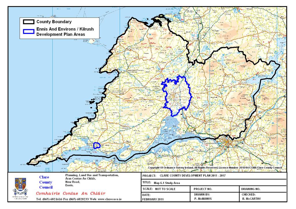
87
88 6.2: Environmental Parameters Each environmental parameter will address: Environmental Parameter Baseline of County Clare The baseline description of the relevant aspects of the current state of the environment; Existing environmental problems; The likely evolution of the environment without the implementation of the Clare County Development Plan Baseline data is essential to establish the current state of the environment to assist the identification, evaluation and monitoring of the likely significant effects of the Clare County Development Plan Baseline data was collected and collated from various sources for each environmental parameter identified in the SEA Directive and Regulations. Significant gaps in the data are discussed under each environmental parameter. The baseline information formed the platform to identify existing environmental problems. Highlighted environmental issues were used to establish the Strategic Environmental Objectives (SEOs). Finally, the likely evolution of the environment without the implementation of the Clare County Development Plan is discussed. This chapter also references a large number of maps associated with the environmental parameters. Clare County Council s GIS system was utilised to collate the data into an operational database allowing the development of individual and/or combination environmental parameter maps and variations of these maps, as well as opportunity and constraint maps for the County at various scales. This baseline information and existing environmental issues together with the SEOs, which are outlined in Chapter 7, will help identify, describe and evaluate the likely significant environmental effects of implementing the Clare County Development Plan and determine appropriate mitigation and monitoring measures. 6.3: Technical Difficulties Encountered and Information Gaps A considerable amount of data was gathered and collated in preparing this SEA Environmental Report. However, there were a number of areas where data did not exist, was not freely available and/or not in GIS format. At County level considerable variations exist in the availability and quality of environmental information for the different parameters. However, it must be noted that this is a National issue. Whilst certain information is readily and easily accessible, such as data relating to water quality, other information is more difficult to ascertain or is not yet available, such as complete ecological coverage, e.g. habitats, trees and hedgerows; coastal sea-level rise data, and landslide susceptibility mapping. Nonetheless, the GIS database established for this SEA should assist in identifying data gaps and as information becomes more available at County and/or local level Significant gaps in the environmental parameters data are discussed under each parameter section below. However, key technical difficulties encountered include: 1. Ecological designation conservation plans some of these plans are currently unavailable 2. Detailed information on health problems and issues in the County are not available 3. Lack of landslide or soil erosion data Noise Maps for the County are not available 16 Recommendation: it is recommended that as information becomes available such data be integrated, where possible, into the GIS database for Clare County Development Plan : Biodiversity, Flora and Fauna 6.4.1: Introduction Biological diversity means the variability among living organisms from all sources including, inter alia, terrestrial, marine and other aquatic ecosystems and the ecological complexes of which they are part; this includes diversity within species, 15 As per EPA submission recommendation June As per EPA submission recommendation June
89 Environmental Parameter Baseline of County Clare between species and of ecosystems (The United Nations Convention on Biodiversity, 1992). A habitat is the type of environment in which a plant or animal species or group of plant and animal species normally lives or occurs. A habitat can also be the characteristics of the soil, geology, water and other plants and animals that make it possible for certain species to occur there. There are a variety of valuable habitats and species that occur in County Clare. Some of these habitats and species are of International or National importance and others are locally important. Areas of International importance for habitats and species are mainly protected as Special Areas of Conservation (SACs) while Special Protection Areas (SPAs) are internationally important for the species and populations of birds they support. These are collectively known as Natura 2000 sites. Areas of National importance are designated as Natural Heritage Areas (NHAs) or proposed Natural Heritage Areas (pnhas). Annexed habitats and species also occur outside of these designated sites, as well as many more common, but extremely important habitats and species. Although approximately 12% of land is officially designated in Ireland the remainder of the countryside is also extremely valuable for habitats and individual species : Designations County Clare has a diversity of habitats and associated flora and fauna, evidenced through the high number of natural heritage designations of International, and National importance. In total, Clare has 37 Special Areas of Conservation (SACs), 10 Special Protection Areas (SPAs), 14 Natural Heritage Areas (NHAs) and 35 proposed Natural Heritage Areas (pnhas). In addition, there is one National Park, i.e. the Burren National Park, 1 Ramsar Site north of the Burren, in Galway Bay, 5 Wildlife Sanctuaries and 4 Nature reserves. It should be noted that the protection of species such as bats, birds, fish and mammals can only be achieved by recognising and protecting breeding, feeding, and roosting/hibernation sites, and by protecting migration and flight paths in the form of wildlife corridors, hedgerows and riparian zones. Fragmentation or obstruction of these corridors will impact negatively on the protection of these species a: Natura 2000 Sites The Habitats Directive (1992) is considered the most important EU initiative to support National and International biodiversity, it provides for the designation and protection of sites that support annexed habitats and species by requiring, among other things, their favourable conservation status to be maintained or restored. These sites of International and National importance are known as Natura 2000 sites and can fall into two categories, namely SAC and SPA. Special Areas of Conservation (SAC) - These sites are established for the protection and conservation of habitats and species listed in Annex I (habitats) and Annex II (species not birds) of the EU Habitats Directive. Potentially damaging activities are listed under Notifiable Actions and permission must be sought from the Minister for Environment, Heritage and Local Government before such actions are carried out. SACs support a diversity of habitats including priority habitats such as limestone pavement, turloughs, active raised and blanket bogs, coastal lagoons, petrifying springs and orchid rich grasslands among others. A number of sites occurring within the County are also designated due to the presence of a particular Annex II species, particularly Lesser Horseshoe bats. Special Protection Area (SPA) These sites are established under the EU Birds Directive, which was implemented in Ireland through the Conservation of Wild Birds Regulations (S.I. No. 291 of 1985). These sites are established for the protection and conservation of Annex I (rare and threatened bird species), and regularly occurring migratory species, and for bird habitats (particularly wetlands). SPAs are of particular ornithological interest and in County Clare can be generally categorised into sites for seabirds, sites for wildfowl and waders, and sites for birds of prey. 74
90 Environmental Parameter Baseline of County Clare Together these Natura 2000 sites form part of the network of sites of highest biodiversity importance in the EU. It should be noted that many of the SPA designations overlap with the SAC designations. The Directive presumes against plans and projects that adversely affects the integrity of a Natura 2000 site from being allowed to proceed except in exceptional circumstances, i.e. where: 1. No reasonable alternatives exist, and 2. There are IROPI - Imperative Reasons of Overriding Public Interest (in the case of all Annex I habitats and Annex II species). In the case of priority habitats, the only IROPI that may be raised are matters of Human Health and Public Safety. The Planning Authority acknowledge the importance of such designated sites and therefore will require any proposals for development on, or adjacent to, a Natura 2000 site to be accompanied by a Habitats Directive Assessment. It is an objective of the Council to require all planning applications for development within, adjacent to, or likely to impact on Natura 2000 sites, to carry out a Habitats Directive Assessment in accordance with the Habitats Directive (1992), including the following: Developments likely to give rise to downstream impacts on water sensitive Natura 2000 sites (including coastal sites). Developments likely to give rise to cumulative impacts on Natura 2000 sites, i.e. taking into account impacts from existing development and possible future development. Developments likely to give rise to in combination impacts on Natura 2000 sites, i.e. developments requiring master plans, ancillary developments. Developments likely to fragment destroy or encroach on Natura 2000 sites and their buffer zones. Developments likely to disrupt the flight paths, movements, feeding and breeding areas of annexed species. Table 6.1 and 6.2 lists the SACs and SPAs respectively occurring in County Clare. The location of each site is illustrated in Map 6.2. The site synopsis, qualifying interests, current threats to SACs and SPAs and generic conservation management objectives of each site are outlined in Appendix 2 of the Habitats Directive Assessment Report associated with the Clare County Development Plan and this Environmental Report b: Natural Heritage Areas Natural Heritage Areas (NHAs) are sites that have been established for the purpose of the conservation of plants, animals and wildlife habitats of National and International importance. These sites were established under the Wildlife (Amendment) Act, 2000, but their statutory protection derives from the Wildlife Acts, They form the foundation for the National system for protecting Ireland s natural habitats. All NHAs in County Clare are bog sites, i.e. blanket bog and raised bog. There are as yet no designated geological NHAs although they are supported by they Act. Proposed Natural Heritage Areas (pnhas) are sites which have been identified through various sources, including early inventories, as areas of biodiversity importance or conservation interest. As such their potential importance is recognised and acknowledged through proper planning and sustainable development. Table 6.3a and 6.3b below lists the NHAs and pnhas occurring in County Clare. The location of each site is illustrated in Map 6.2. The site synopsis of each can be accessed on the National Parks and Wildlife website. 75
91 Environmental Parameter Baseline of County Clare Table 6.1: Special Areas of Conservation in County Clare Code SAC Name Ballyallia Lake SAC Ballycullinan Lake SAC Ballyogan Lough SAC Black Head - Poulsallagh Complex SAC Danes Hole, Poulnalecka SAC Dromore Woods and Loughs SAC Inagh River Estuary SAC Pouladatig Cave SAC Lough Gash Turlough SAC Moneen Mountain SAC Moyree River System SAC Poulnagordon Cave (Quin) SAC Galway Bay Complex SAC Loughatorick South Bog SAC Ballyteige (Clare) SAC Ballyvaughan Turlough SAC Glenomra Wood SAC Carrowmore Point To Spanish Point and Islands SAC Termon Lough SAC Glendree Bog SAC East Burren Complex SAC Old Domestic Building (Keevagh) SAC Newhall and Edenvale Complex SAC Pollagoona Bog SAC Newgrove House SAC Lower River Shannon SAC Old Farm Buildings, Ballymacrogan SAC Ballycullinan, Old Domestic Building SAC Toonagh Estate SAC Carrowmore Dunes SAC Kilkee Reefs SAC Slieve Bernagh Bog SAC Old Domestic Buildings, Rylane SAC Ratty River Cave SAC Knockanira House SAC Kilkishen House SAC Tullaher Lough and Bog SAC Table 6.2: Special Protection Areas in County Clare Code SPA Name Cliffs of Moher SPA Inner Galway Bay SPA Ballyallia Lake Wildfowl Sanctuary SPA Lough Derg (Shannon) SPA River Shannon and River Fergus Estuaries SPA Illaunonearaun SPA Loop Head SPA Slieve Aughty Mountains SPA Mid - Clare Coast SPA Corofin Wetlands SPA 76
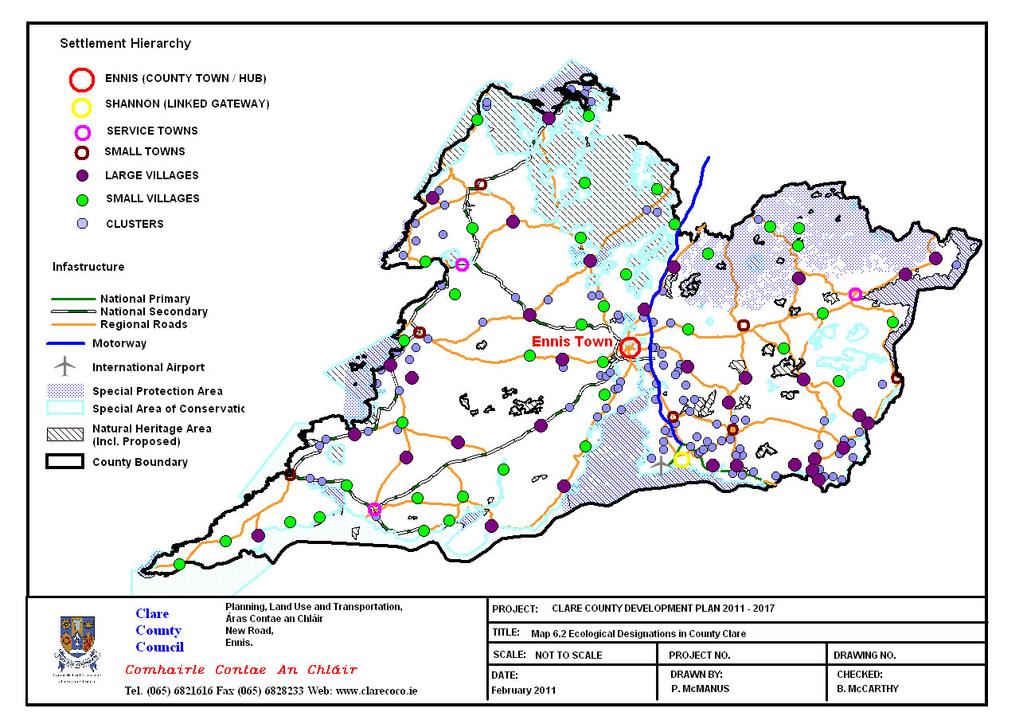
92
93 Environmental Parameter Baseline of County Clare Table 6.3a: Natural Heritage Areas in County Clare Code NHA name Doon Lough NHA Ayle Lower Bog NHA Loughanilloon Bog NHA Cloonloum More Bog NHA Lough Naminna NHA Lough Atorick District Bogs NHA Slievecallan Mountain Bog NHA Cragnashingaun Bogs NHA Gortacullin Bog NHA Woodcock Hill Bog NHA Lough Acrow Bogs NHA Oysterman's Marsh NHA Maghera Mountain Bogs NHA Illaunonearaun NHA Table 6.3b: Proposed Natural Heritage Areas in County Clare Site Code Site Name Designation Ballycar Lough pnha Cahermurphy Wood pnha Cloonlara House pnha Durra Castle pnha Fort Fergus (Ballynacally) pnha Inchicronan Lough pnha Lough Goller pnha Derrygeeha Lough pnha Newpark House (Ennis) pnha Paradise House (Ballynacally) pnha Poulnasherry Bay pnha Turloughnagullaun pnha Farrihy Lough pnha Castle Lake pnha Cahiracon Wood pnha Cahiracalla Wood pnha Cloonsnaghta Lough pnha Derryhumma Wood pnha Derrymore Wood pnha Dromoland Lough pnha Fin Lough (Clare) pnha Garrannon Wood pnha Gortglass Lough pnha Lough Cullaunyheeda pnha Lough O'Grady pnha Derryvinnaun Wood pnha Caherkinallia Wood pnha St. Senan's Lough pnha Lough Cleggan pnha Cloonamirran Wood pnha Lough Graney Woods pnha Scattery Island pnha Knockalisheen Marsh pnha Rosroe Lough pnha Lough Derg pnha 78
94 Environmental Parameter Baseline of County Clare 6.4.2c: Other Sites for Environmental and Ecological Protection There are a number of other sites across the County that have been designated for environmental and/or ecological protection. These sites include the Burren National Park, one Ramsar site (Galway Bay), 5 Wildlife Sanctuaries (Mutton Island, Islandavanna, Tullagher Lough, Ballyallia Lough and part of the Inagh river) and 4 Nature Reserves (Ballyteigue, Caher (Murphy), Keelhilla (Slieve Carron) and Dromore). These areas are hugely important for the protection of biodiversity at a local level and also in the provision of a vital amenity and educational resource in the County. Outside the designated sites, habitats associated with agricultural activity and other land uses represent a further biodiversity resource. Habitats such as hedgerows have been an important feature of the landscape in most parts of Ireland for centuries. They provide a habitat for many species and also function as wildlife corridors for animals to move through. For example, there are a large number of Lesser Horseshoe Bat (Rhinolophus hipposideros) designated sites throughout the Clare area. It is particularly critical that wildlife corridors, tree lines and hedgerows within the area of Lesser Horseshoe Bat roosts are retained to allow for the free movement of these bats and others species within and through the surrounding area. Riparian zones and field margins can provide food, shelter, breeding areas and corridors for insects such as beetles and ground nesting birds. An indication of the range of habitats in the County can be ascertained through land use data, in particular the European Corine Datasets (2000, 2006). In addition, Clare County Council commissioned a number of specialist consultants to conduct field-by-field habitat mapping surveys for almost half of the County, creating an important record of local biodiversity throughout the County. Habitat mapping has taken place in North Clare, South Clare (including the Shannon Estuary), Ennis and Environs, the majority of Mid Clare and the Lough Derg area. Burren National Park The Burren National Park is located in the southeastern corner of the Burren and is approximately 1500 hectares in size. It contains examples of the significant major habitats within the Burren area including; Limestone Pavement, Calcareous grassland, Hazel scrub, Ash/hazel woodland, Turloughs, Lakes, Petrifying springs, cliffs and Fen. Mammals found in the Burren National Park include the Pygmy Shrew (Surex mjnutus); Field Mouse (Apodemus sylvaticus), Brown Rat (Rattus norvegicus), Bank Vole (Clethrionomys glareolus), Rabbit (Oryctulagus cuniculus), Irish Hare (Lepus timidus hibernicus) and Otter (Lutra lutra). Much of the National Park is designated as a SAC and its potential as a UNESCO-accredited European Geopark is being investigated and developed based on its unique natural features. Clare County Council has sought UNESCO World Heritage Site Status for the Burren area and, to date, has been included on the tentative list for World Heritage Site status. River Shannon and Lough Derg The Shannon Estuary (bordered by Counties Clare, Limerick, Kerry) is recognised as a natural habitat with an overall designation as a SAC and specific designations of NHA and SPA. The Lower River Shannon encompassing Lough Derg is designated an SAC and Lough Derg (Shannon) and River Shannon Estuary are designated SPAs. Lough Derg, the largest lake on the Shannon, bordered by Counties Clare, North Tipperary and Galway is home to areas of natural and semi-natural habitat, particularly wetlands, in the areas of general ecological/biodiversity interest. These habitats of significance were highlighted as a result of a habitats survey undertaken in the County. Lough Derg is also recognised and listed on the Register of Protected Areas under the Water Framework Directive and represents an important regional resource, with requirements for coordinated planning and environmental management : Existing Environmental Problems Biodiversity has become an integral part of the conservation of our habitats and species and is a measure of the number, variety and variability of living organisms within a given area. The primary mechanism for conserving, protecting and enhancing 79
95 Environmental Parameter Baseline of County Clare biodiversity in the wider countryside is through the National Biodiversity Plan 2002 of which a key concept is that Local Authorities and other Agencies share responsibility for the conservation and sustainable use of biodiversity. Elsewhere, site designations and wildlife legislation are key concerns. In County Clare habitat loss, fragmentation, and disturbance to wildlife are probably the greatest threats, with climate change and invasive species also important issues. Other issues include intensification or abandonment of agricultural activity, housing development, run off, contaminated sites, forestry monocultures. In general, development in the County is not significantly impacting upon ecological designations which have been afforded protection through European legislation. Where available the designation qualifying interests, current threats to designation qualifying interests and conservation management objectives of each site are outlined in Appendix 2 of the Habitats Directive Assessment Report. However, localised adverse impacts on some designated sites may be occurring as a result of individual developments both in the form of multi-unit housing development and one off dwellings. Natural heritage is not confined to statutory designated sites, but is found throughout the countryside and in built-up areas. When development occurs on Greenfield sites in the County, natural and semi-natural habitats are replaced with artificial surfaces and there is inevitably an impact on existing flora and fauna. Developments on Greenfield sites often results in fragmentation and a loss of hedgerows which act as wildlife corridors, stepping stones and ecological networks. These corridors are essential in order for wildlife to move from one area to another for breeding, in search of food, etc. The significance of this potential loss is dependant on the scale of development and the cumulative and in-combination effects. Many habitats are considered semi-natural as they have been altered by human activity. For example, the vast majority of grasslands are grazed and/or mown; most deciduous woodlands are grazed and have been at least partially planted at some stage. Grasslands which are farmed intensively and which have been re-seeded and/or heavily fertilised support much fewer species than extensively or traditionally farmed grasslands. Drainage is damaging to wet grasslands, as is overgrazing. In the Burren, scrub is a problem as it is expanding onto areas of limestone pavement and dry calcareous grassland, while in other parts of Clare, woodland/ scrub habitat is declining, mainly due to clearance for agriculture or housing. The reclamation of land for agriculture, development of land and land abandonment pose a threat to limestone pavement. Water pollution and the alteration of hydrology in limestone areas can affect limestone features such as cave systems. Many rivers have been modified to reduce flooding, leading to the loss of flood plains. Climate change is a transboundary issue affecting the entire globe and is fundamental to social stability and sustainable development. In 2007, the European Union agreed new climate and energy targets by % reduction in greenhouse gas emissions; 20% energy efficiency and 20% of the EU s energy consumption to be from renewable sources all by Following on from this Ireland has given an undertaking to reduce net emissions by at least 80% by 2050 (on 1990 levels) and an emissions reduction trajectory of an average of 3% per year until 2020 as set out in the Climate Change Bill, Most greenhouse emissions are related to energy generation, transport, agriculture, and industry sectors. Focus is being put on predicting how a changing climate will impact on some of our most threatened species, for example, species at the range limits. Sea level rise is another issue of concern. Alternative energy options are being explored in the County. A common concern in relation to wind energy developments relates to impacts on peat soils and hydrogeology, impacts on bird species, and habitat disturbance. These are discussed in more detail in the Clare Wind Energy Strategy Vol. 5 of Clare County Development Plan Invasive alien species are defined as plants or animals which did not originally occur in Ireland before human colonisation of the country and which are expanding their numbers and distribution so as to cause a competitive threat to such native fauna and flora. Invasive alien species are rated globally as the second biggest threat to biodiversity after habitat loss. In Ireland the scale of impacts is immense not just on biodiversity but also on agriculture, forestry, fisheries, water quality, tourism, 80
96 Environmental Parameter Baseline of County Clare infrastructure, etc. A number of invasive, non native species of both flora and fauna are present throughout the County, for example, the Zebra Mussel which poses a direct threat to aquatic ecosystems and human activities by blocking water pipes and boat engines and affecting our native fish species. Clare County Council, in association with Clare Biodiversity Ltd. and The Heritage Council conducted a project aimed at providing a current review of the distribution and threats posed by Invasive Alien Species in the County, and to present a draft strategy for a coordinated control programme (EirEco Environmental Consultants, 2009). Floodplains and wetlands are essential for flood control, pollution control, water supply, while peat lands also serve as vital carbon sinks that could help address climate change. Locating development in an area at risk from flooding (a floodplain) can lead to property damage, human stress, hardship and ill-health, problems obtaining property insurance and consequential demands for the expenditure of Local Authority or Central Government resources on flood protection works. The construction of protection works at the time of the development, or at a later date, will incur significant additional costs and will not provide absolute immunity from the risk of flooding. Development located in an area prone to flooding can therefore increase flood risk and/or necessitate heavy expenditure on flood protection works. In times of flood, a river can flow not only through its normal channel but also along its floodplains. Any constriction of the natural flow path can restrict flow, back-up the river and lead to increased flood levels upstream. The construction of buildings or houses, and particularly embankments for infrastructure or protection, in or across a floodplain or in areas at risk of flooding can therefore not only put the development itself at risk of flooding as described above, but can also increase the flood risk for land and properties upstream. The County as a whole is at risk from several sources of flooding including river and estuarine flooding, however, a significant threat posed by flooding is by way of coastal flooding particularly during storm surges. Floodplains have, therefore, a valuable function both in attenuating or storing floodwater and through their ability to convey floodwater in a relatively controlled and safe way. Clare County Council conducted a Strategic Flood Risk Assessment (SFRA) which is discussed in Volume 3 with flood zoning mapping included in Volume 2 of the Clare Count Development Plan Clare County Council also conducted a County wetland survey in 2008 to record and map significant areas of wetland in the County. There are 34 wetland types in County Clare (23,440 ha), 22 of which are listed in Annex I of the EU Habitats Directive. Areas of floodplain and wetlands should therefore be recognised and preserved as natural defences against flood risk : Evolution of Biodiversity in the absence of the CCDP County Clare has a vast and diverse natural heritage and as such there are many plans and guidance documents at European, National and Local level, which aim to guide development in order to ensure that this natural heritage is protected. However, in the absence of the CCDP there would not be a framework within which to regulate, aid and/or control development whether economic, social or environmental. In the absence of the Plan pressures on biodiversity, flora and fauna would occur and possibly escalate even though designated habitats and species are protected under EU and National legislation. Loss, disturbance, deterioration and fragmentation of biodiversity, flora and fauna are the greatest threats for biodiversity as well as changes in land use (increase, decrease or change in agricultural activity or other land use particularly energy crops). Also, other important habitats currently not listed or proposed for statutory designation and their ecological connectivity would be susceptible to adverse changes through incompatible uses, resulting in a diminished natural environment and loss of biodiversity, flora and fauna. Development would have no policy regulation or guidance in relation to where or at what scale it could occur. Furthermore, the cumulative effects of individual developments would not be easily overseen or coordinated and assessed for their effects on habitats, species and their ecological connectivity. Activities which would lead to, for example, Greenfield site development, wastewater treatment facilities, increased runoff due to urbanisation, etc. are all factors which are influenced by the 81
97 Environmental Parameter Baseline of County Clare Development Plan process and can potentially impact adversely on habitats and species. The role that biodiversity plays can not be reproduced synthetically as it is a process that has taken thousands of years to develop. Each element of biodiversity is dependent on or responsible for another element. If something is effected within the biodiversity system, it can have a ripple effect'. Due to the interrelationships of biodiversity, flora and fauna with the other environmental parameters they would also be adversely affected to varying degrees. For example, development of floodplains would result not only in direct loss of habitats and species, but would also disrupt the hydrological system which would have consequentially negative effects on others aquatic environments. Thus, under these circumstances the evolution of biodiversity, flora and fauna in the absence of the Plan would be highly dependent on the rate and extent of uncontrolled developments. Ultimately, the potential for fragmentation, loss, and/or deterioration of biodiversity, flora and fauna would occur. 82

98 6.5: Population, Human Health and Quality of Life Environmental Parameter Baseline of County Clare 6.5.1: Introduction This section discusses the impact of the Plan on the population of County Clare. It must be noted at this stage that specific data relating to spatial analysis of the County could not be mapped as there was a deficiency in available data information : Historical Population Trends The population of County Clare based on the 2006 Census was 110,950, an increase of 7.4% since County Clare has 151 Electoral Districts (EDs) within the zones 1, 2, 3 and 7. The Mid West Regional Planning Guidelines (MWRPG s) identifies a Zone based strategy for the Mid West Region highlighting distinct characteristics of nine different areas within the region (Map 6.3). The MWRPG s propose that the identified zones be developed in ways that reflect their particular characteristics and outlines the development potential and development needs of the various zones in the region. Map 6.3: Regional Development Zones Source: Mid West Regional Authority (2010) Table 6.4 demonstrates population growth in County Clare over the last Census period compared with the Mid West Region and the State. Three major trends determine population change, namely; the number of births, the number of deaths and migration. The 2006 Census results showed the national population increased by 17% between 1996 and 2006 to 4.2 million. At a County level, the population of Clare grew steadily by 18% between the same 10 year period to a total population of 110,950 (Table 6.5). In order to properly plan for the sustainable development of County Clare through the Development Plan period up to 2017, it is vitally important to be aware of the population for whom the Plan will cater. The target population assigned by the MWRA for County Clare is 132,022 to Figure 6.1 highlights the age demographics for the different areas of County Clare in The age of the population is significant because it represents the number of people available to become part of the labour force as well as indicating the proportion of the population who might be classified as dependent. South Clare and Ennis & Environs have the highest percentages of and year olds, while West Clare has the lowest percentage (of and year olds) with the 65+ age group 17 As per EPA submission recommendation June
99 Environmental Parameter Baseline of County Clare comprising the greatest part of their population. This underlines a clear contrast in age profiles between the urban corridor and the rural parts of the County. Age dependency ratios offer helpful summary measures of the age structure of the population at a particular point in time. The young and old dependency ratios are derived by expressing the young population (aged 0-14 years) and the old population (aged 65 years and over) as percentages of the population of working age (15-64 years). The age dependency ratio for County Clare is 49.8% which is higher the state dependency ratio of 45.8%. Table 6.4: Population Growth for the Mid West Region % Change Zone % Zone 2 South West % Zone 3 North West % Zone 7 North East % Total Co. Clare 103, , % Mid West Region 339, , % State 3,917,203 4,239, % Source: Census 2002 & 2006 Table 6.5: County Clare: Population Change % Change % Change Clare County 94, , , East Clare 12,576 13,584 14, Ennis & Environs 21,461 26,063 28, Kilrush Urban 2,594 2,699 2, North Clare 16,451 17,300 18, South Clare 24,323 27,385 29, West Clare 16,601 16,246 16, Source: CSO 2006 Figure 6.1: Plan Area Age Profile in County Clare in West Clare South Clare East Clare North Clare Ennis & Environs Kilrush Urban Source: CSO (2006) 84
100 6.5.3: Distance to Work Environmental Parameter Baseline of County Clare While a persons journey to work time and place of work is a factor in determining one s quality of life, it is also a measure of the sustainability of settlements. In Clare, 35.1% of people aged 5 and over travelling to work, school or college are travelling over 10Km, and 44.2% are travelling less than 9Km to their place of work (Table 6.6). It should be noted 20.7% did not state the distance when completing the Census questionnaire, therefore the percentages for travelling could be higher (CSO 2006). Table 6.6: Persons Aged 5+ by distance travelled to work, school or college, Km 1 Km 2 4 Km 5 9 Km Km Km Km 50 Km+ Not Stated Total Co. Clare East Clare Ennis & Environs Kilrush North Clare South Clare West Clare Source: CSO : Household Size The national trend is one of falling household size from an average of 3.14 persons per household in 1996 to 2.81 in 2006 (Census 2006). County Clare has followed the same trend with an average of 3.13 persons per household in 1996 to 2.79 in Whilst the census maps demonstrated the size of households in County Clare is declining in line with the pattern elsewhere in the Country, the actual number of households has been increasing. This will have implications for the number and type of houses required to meet the housing needs of County Clare over the period of the Clare County Development Plan , and in particular, how and where the balanced growth of County Clare is facilitated : Unoccupied Housing While the Census does not provide data on holiday homes, it does provide information on unoccupied houses which gives an indication of vacant houses in the area. The percentage of vacant dwellings in County Clare on the night of the census was 21.5% (Table 6.7) which is the second highest rate in Munster after County Kerry. The national average vacancy rate is 16.7%. West Clare has the largest vacancy percentage followed by North Clare where 31.6% of houses are vacant. This pattern coincides with the fact that both West Clare and North Clare are situated on the coast and many of the houses are holiday home developments. Consequently, this has an effect on the provision of services in these areas and how the future population growth is planned. Table 6.7: Percentage of Unoccupied Houses in County Clare Total % Geographic Area Occupied Unoccupied housing Unoccupied Clare County % East Clare % Ennis & Environs % Kilrush Urban % North Clare % South Clare % West Clare % Source: CSO
101 Environmental Parameter Baseline of County Clare West Clare has seen a population increase of 4.6% between 2002 (16,246) and 2006 (16,989), representing a total increase of 743 persons. This differs from the previous Census period where a population decrease of 2.1% (from 16,601 to 16,246) was recorded (Figure 6.2). Figure 6.2: West Clare Population Change ,200 17,000 16,989 16,800 16,600 16,601 16,400 16,200 16,246 16,000 15, Source: CSO : Population Targets Future population targets 18 are an essential element of a County Development Plan as they have direct effects on various housing, community, and educational provisions and assist in determining future development and how to plan for it. In 2009, the DoEHLG published a set of population targets for each region in Ireland for The Mid West Regional Planning Guidelines divided the appropriate population targets between the 9 different zones in the Mid West Region. Table 6.8 sets out these targets as they apply to the Mid West Region and individual Counties. County Clare has an anticipated population growth of 141,600 by 2022, a growth rate of 31%. Map 6.4 highlights the population targets for the different zones applicable to County Clare Electoral Districts (EDs) for 2017, which will accommodate the target increase in population of 21,072 from 2006 to a total population of 132,022 in The emphasis on the Gateway and Hub is evident with Zone 1 accounting for nearly 84% of the growth for the County. Table 6.8: Population Targets 2022 by County 2006 Percent Percent 2016 Totals 361, % 427, % 462, % Source: Mid-West Regional Planning Guidelines (2010) Map 6.4: Projected Growth to 2017 by Zone 2022 Percent 2022 Clare 110,950 31% 131,321 31% 141,600 31% Limerick 124,265 34% 147,081 34% 157,065 34% City 59,790 17% 70,768 17% 81,240 18% N.Tipp 66,023 18% 78,145 18% 82,123 18% 18 Section updated as per EPA submission recommendation June
. By contrast the Ennis Hub (population 24,253 in 2006) experienced population growth at 120.")
102 Environmental Parameter Baseline of County Clare Source: Mid-West Regional Planning Guidelines (2010) The Limerick/Shannon Gateway (population 99,979 in 2006) has experienced particularly slow population growth since 2002 (at only 56.8% of the National population growth rate). By contrast the Ennis Hub (population 24,253 in 2006) experienced population growth at 120.4% of the National population growth rate. The DoEHLG s report on the State of the Regions (2009) requires the Limerick/Shannon Gateway to play a crucial role in shaping a new growth dynamic for the Mid West Region. The report emphasises that growth in the Gateway would need to be complemented by strong growth in the larger of the lower order towns, and therefore the Ennis Hub should play an important role. Clare County Council has directly transposed the target populations from the DoEHLG and Mid-West Regional Authority into the preparation of the Clare County Development Plan Table 6.9 contains the breakdown of the population targets within County Clare and the various allocations to different zones and Service Towns highlighting the emphasis on the Gateway and the Hub as required by the DoEHLG. For the purpose of the Development Plan, which ceases to have effect at the end of 2017, the target population for County Clare has been calculated as 132,022 for that year. Table 6.9: Population Targets Breakdown Population 2002 Population 2006 Service Towns 2017 Gateway Hub Remainder of Zone 6 Targets 2017 Zone 1 69,341 75,985 +1,753 +5,981 +7,219 90,938 SW Clare 2 16,230 16, ,767 19,397 NW Clare 3 13,200 13, ,409 16,146 NE Clare 7 4,506 4, ,541 Total 103, ,950 +2,406 +1,753 +5, , ,022 1 Shannon/2 Ennis/3 Kilrush/4 Ennistymon/Lahinch/5 Scarriff/Tuamgraney/6 Remainder of Zone includes total population of settlements and rural area Source: MWRA (2010) 87

103 Environmental Parameter Baseline of County Clare 6.5.7: Human Health and Quality of Life Radon levels in the County have been collated from the Radiological Protection Institute of Ireland 19. The estimated percentage of homes above the Reference Level is indicated on Map 6.5 as per the associated legend. Human health data for the County is not easily available. However, impacts on human health and quality of life may derive from any of the environmental parameters. Ultimately, all of the effects of a development on the environment impinge upon human beings and their quality of life, both positively and negatively. Direct effects relate to matters such as water and air quality, noise, and landscape change. Indirect effects relate to such matters as flora and fauna. Accordingly, the topic of human beings and their quality of life is addressed in this Environmental Report by means of an appraisal of the indirect effects, etc. of the Development Plan on the other environment parameters, of which human beings and their quality of life are an integral part. Where appropriate, mitigation measures to reduce/avoid adverse impacts are identified and incorporated into this Report and the Plan under the other environmental parameters. Map 6.5: Estimated Percentage of Homes above the Reference Level in Co. Clare > 20% 10% - 20% 5% - 10% 1% - 5% < 1% 6.5.8: Noise Measures to deal with noise pollution associated with major noise sources such as transportation and infrastructure in County Clare have been taken into consideration by the Council by adopting a Noise Action Plan. The Clare Noise Action Plan was published in October 2008 and is a five year strategic document published under the Environmental Noise Directive 2002/49/EC to address noise from major transport sources to which individuals are exposed. The Directive does not include noise caused by an individual, noise from domestic activities, noise caused by neighbours or noise at places of work : Existing Environmental Problems The current national seasonally adjusted unemployment rate stands at 13.6 % (December 2010). The ESRI (2010), in their Quarterly Economic Commentary, have estimated that the rate of unemployment is expected to average 13 ½ per cent in 2011 and 13 per cent in This increase presents serious challenges for the future of both the national and local economy. Challenges for the future include retaining the young working population of Clare to prevent high levels of emigration 19 As per EPA submission recommendation June
104 Environmental Parameter Baseline of County Clare by encouraging them to live and work in the area. Additionally, there is an increasing trend of elderly age cohorts and their needs also must be catered for. The oversupply of holiday or second homes within an area can contribute to the reduction in amenity for the permanent population and can impact negatively on the proper planning and sustainable development of an area. Population health and quality of life are very much influenced by the presence and state of the other environmental parameters. Thus, all of the issues raised under the other environmental parameters are important issues which cannot be comprehensively covered in this section, but which are considered in the overall assessment : Evolution of Population in the absence of the CCDP In the absence of the CCDP there would not be a framework within which to regulate, aid and/or control development whether economic, social or environmental. A lack of controlled development could lead to imbalance in population distribution in particular areas within the County which would put pressure on adequate service provisions and infrastructural facilities, thus effecting the natural environment in which the population lives leading to human health and quality of life issues. In the absence of an agreed target population and appropriate zoning of settlement land all of the environmental parameters would be adversely affected to varying degrees. In order to properly plan for the sustainable development of the County, it is essential to be aware of the population for whom the County will cater. The assigned target population of 132,022 to 2017 must be taken into account when formulating objectives and polices for the County. In assessing demographic projections, cognisance has been taken of the impact of population projections on housing, education and workforce. In the absence of the Plan, Core Strategy and population targets; infrastructure, including services and housing provision would not be catered for accurately. Issues affecting the current population in addition to the population increase may not be realised and could result in deterioration of the environment and mismanaged resources. 89
105 Environmental Parameter Baseline of County Clare 6.6: Soil and Geology 6.6.1: Introduction This Section discusses soils and geology which is defined as all natural materials underlying a development, from the ground surface to an appropriate depth underground. This includes bedrock, subsoils, topsoils and geological features such as karst, caves and areas of geological interest : Soils The upper most layer of the earth s surface is generally termed soil. It comprises for the most part organic matter, minerals and fine to course grained weathered rocks. The variability in the constituent parts and the percentage content of each in the soil matrix results in differing characteristics. Numerous natural factors influence the composition of soils, notably bedrock, climate and topography. This has implications for overall land use and the appropriateness for differing land use practices. The main Great Soil Groups in County Clare described below are illustrated by Map , while Map 6.7 shows soils and subsoils based on the EPA Mapping Project (K. Daly and Fealy, 2007). Brown Earths are relatively mature well drained mineral soils processing a uniform soil horizon. Most Brown Earths occur on lime deficient parent materials and are therefore acid in nature i.e. Acid Brown Earths. Brown Earths can also occur on more lime-rich materials. Brown Earths possess medium soil texture and have good structure and drainage characteristics and are extensively cultivated. They have relatively low nutrient status. Brown Podzolics Brown podzolics have a good mix of mineral and organic matter in the surface layer and generally have a low inherent nutrient status and display good physical characteristics. They are usually devoted to cropping and pasture production. Grey Brown Podzolics are usually formed from a calcareous parent material which counters the effects of leaching. This restricts the podzolisation process. Grey Brown Podzolics are good all purpose soils. Gleys are soils in which the effects of drainage impedance dominate and which have developed under the influence of permanent or intermittent waterlogging. Waterlogging may be due to a high water table giving groundwater gleys, a perched water table due to impervious nature of the soils giving a surface water gley or from seepage or runoff from slopes. Most gleys have poor physical conditions and restricted growth seasons. Peaty gleys have organic horizons containing 20 to 50% organic matter on the surface and are found in wetter conditions. Rendzinas are shallow soils not more than 50cm deep derived from parent material containing 40 percent carbonates. The surface horizon has a strong structure with a neutral or alkaline reaction. Use is often limited by shallowness. Blanket Peats Peats are characterised by having high organic matter content, usually over 30 percent and are at least 30 cm deep. Blanket peat (or climatic peat) accumulates in areas of high rainfall and humidity predominately in the west and upper part of mountain ranges. Poor drainage and adverse physical conditions limit their agricultural use. Basin peats have formed in lake basins, hollows or river valleys or where the subsoil is impermeable. Two types of basin peats are recognised, raised bogs and fen peats. Fen peats are formed under the influence of base rich groundwater. The agricultural use of basin peats can be increased following drainage and reclamation works : Geology Geology encompasses the understanding and study of the solid and liquid matter that constitutes the earth and the processes by which they are formed, moved and changed. Its understanding is necessary to fully appreciate the geological factors that shape and influence the world and its particular structure. The bedrock foundation, 20 Key updated to answer EPA submission recommendation June
106 Environmental Parameter Baseline of County Clare with hundreds of millions of years in the formation and shaping, and the more recent history of geomorphological processes such as coastal erosion and limestone solution are what has created that underlying geodiversity (Parkes, McAteer and Engering, 2005). The geology of the County is shown in Map 6.8. The predominant rock types in the Clare area are sedimentary rocks, limestone and sandstone and shales in particular. There are also some minor igneous rocks. The most common metamorphic rocks in Clare are Slates, which were originally shales. In 1998 the Geological Survey of Ireland, in conjunction with the National Parks and Wildlife Service established the Irish Geological Heritage Programme. There are 89 areas of geological importance within the County that are considered to be of national importance as best representative examples of particular geological formations or features, for example, cave systems, limestone pavements and mushroom stones. The Geological Survey of Ireland (GSI) as part of their Irish Geological Heritage Programme has identified some of these areas as Geological Heritage Sites. Sites identified in County Clare by the GSI are outlined in Map 6.9 in this report. The programme aims to identify and select sites of geological heritage within Ireland for future designation as NHAs : Existing Environmental Problems Changes in soils result from both natural processes and human activities and contribute to their dynamic and evolving nature. However, anthropogenic activities can occur at a much faster rate and to a greater extent than natural processes. Of concern is the physical, biological and/or chemical degradation of soils, which can cause the direct loss of soil (data relating to the potential for soil erosion and landslides is currently unavailable, although the Wind Energy Strategy references landslide data 21 ), and indirectly impair ecologically essential soil processes, reduce productive capacity, and deplete soil quality and biodiversity. In general the main pressures on soil resources are caused by intensive agriculture and organic waste disposal, forestry, industry, peat extraction and urbanisation and infrastructure development. These activities can lead to soil degradation including loss of organic matter, decline in soil fertility, acidification, diffuse pollution including organic waste disposal and air deposition, industrial contamination, salinisation, loss of soil stability, increased soil erosion, soil compaction, contamination, loss of biodiversity, loss of soil to urbanisation, buildings and infrastructure, and flooding. The type and depth of soil has direct implications on water movement which can lead to increased pollution threats if not properly considered. Land spreading of both organic and artificial fertilisers, the use of pesticides/herbicides/fungicides can, if inappropriately used, particularly when adverse weather conditions prevail, be carried from the point of use to rivers, lakes and ground water resources. Land spreading of farm effluent and application of fertilisers in agricultural areas is a delicate balance, particularly on low permeability soils with possible implications on water quality (discussed in Section 6.7). Also in certain areas the soil s poor percolation characteristics render them unsuitable for conventional septic tank methods of domestic effluent disposal. Geological Heritage sites are supported under the Wildlife (Amendment) Act, 2000 but no geological NHAs exist as yet. There were 208 applications to register quarries in County Clare under Section 261 of the Planning and Development Act, 2000 (as amended) however approximately 40 abandoned/unused quarries were identified during the registration process. Of the remainder of active quarries there are approximately 15 quarries located on the coastal fringes in Clare, which are in areas of high scenic value. Map 6.10 indicates the distribution of known quarries in the County. Adverse environmental impacts can occur from extractive industries, from both existing quarries and new quarry extensions if not managed. Extraction ultimately leads to the total removal of a resource within a given area and can lead to localised environmental issues. The implications of this for the natural and cultural environment can result in the landscape being eroded, archaeological heritage being 21 As per EPA submission recommendation June
107 Environmental Parameter Baseline of County Clare lost, and pollution occurring. Due to the nature of quarrying it can result in reprofiling of the landform which can have adverse visual impacts on the landscape and on scenic routes. Biodiversity, groundwater and aquifer resources are also vulnerable, issues include run-off and water management. The extraction of materials from the foreshore, beaches, sand dunes and water courses can have adverse impacts on ecosystems in an area and coastal erosion : Evolution of Soil and Geology in the absence of the CCDP Section 261 of the Planning and Development Act, 2000 (as amended) provides for the registration and control of quarries, and the Quarry and Ancillary Activity Guidelines for Planning Authorities 2004 (Department of the Environment Heritage and Local Government) are useful to Local Authorities when assessing applications for quarry developments. Furthermore, the Planning Authority in Clare County Council is currently putting together best practice guidelines for the integration and rehabilitation of quarries in County Clare 22. Also, the current pre-planning process will advise inclusion of rehabilitation/restoration plans in new applications, where a condition will be attached to this end in the event of permission being granted. There is no formal European legislation to protect soils. Presently, in Ireland the protection of the soil environment is indirectly enforced through the Code of Good Agricultural Practice (2006). However, in September 2006, the European Commission published the final Thematic Strategy for Soil Protection (COM(2006)231 final) and a proposal for a Directive establishing a framework for the protection of soil across the EU (COM(2006)232). The overall objective of the strategy is the protection and sustainable use of soil, based on the guiding principles of preserving soil functions, preventing further degradation and restoring degraded soils to a level of functionality consistent with current and intended use. Once adopted the European Soil Thematic Strategy will guide and frame Ireland s approach to developing its own soil protection strategy 23. Thus, in the absence of the CCDP there would not be a framework within which to promote sustainable development to and regulate, aid and/or control development whether economic, social or environmental. Development would have no policy regulation or guidance over where or to what extent it could occur, leading to a significant deterioration in the soil and geology environment. In the absence of a Plan greenfield sites may be developed over existing brownfield site resulting in the accumulation of non-renewable soil and subsoil resources. The harvesting of peat would be likely to continue resulting in losses of peat soils. Quarrying activity would operate without policy control thus having a potentially negative effect on geology and geological heritage. It is likely that there would be applications to set up and/or expand quarrying activities in certain areas which are underlain by valuable deposits. Such development would also result in the reduction of non-renewable subsoil and soil resources. Any uncontrolled development would have a direct negative impact due to soil loss and run-off, directly impacting on water and also causing indirect impacts from potential contamination due to ancillary works associated with the development or lack of appropriate waste water facilities. Furthermore, the cumulative effects of individual developments would not be easily overseen or coordinated and assessed for their effects on soil and geology. Soil and Geology is closely linked to biodiversity and landscape thus loss, fragmentation and/or deterioration of soils and geology would have a direct negative impact on biodiversity and the landscape. The scenic landscapes in County Clare have formed over hundreds of millions of years by various geological processes, each one leaving its mark in the rock record, and thus have the potential to shed light on the evolution of the Clare landscape. 22 As per EPA submission recommendation June As per EPA submission recommendation June
108
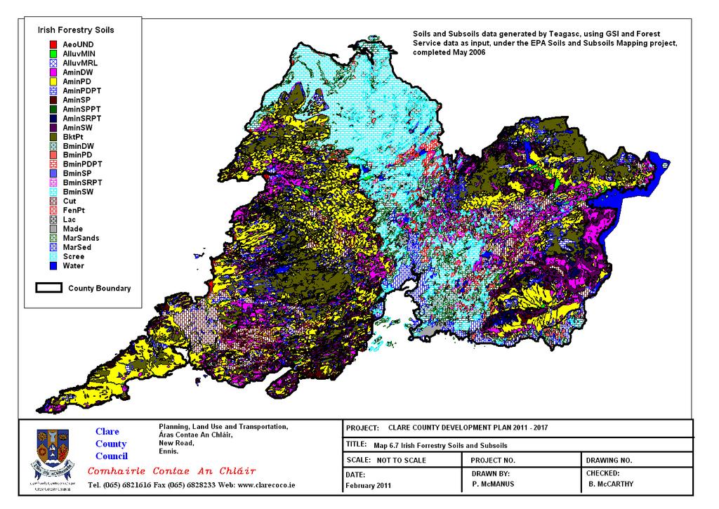
109
110
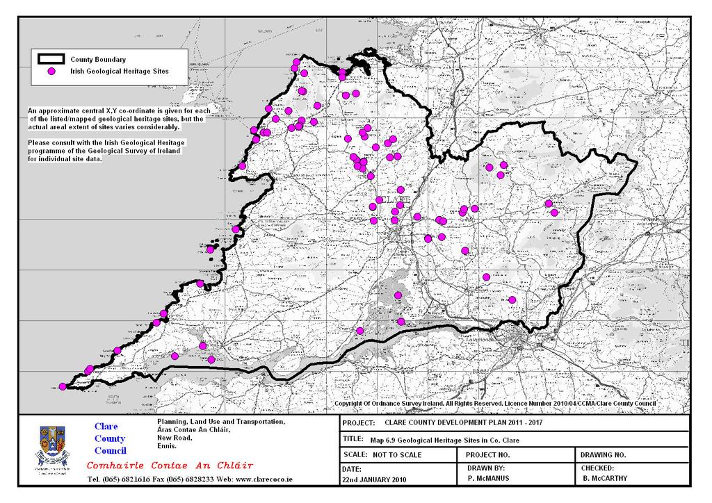
111
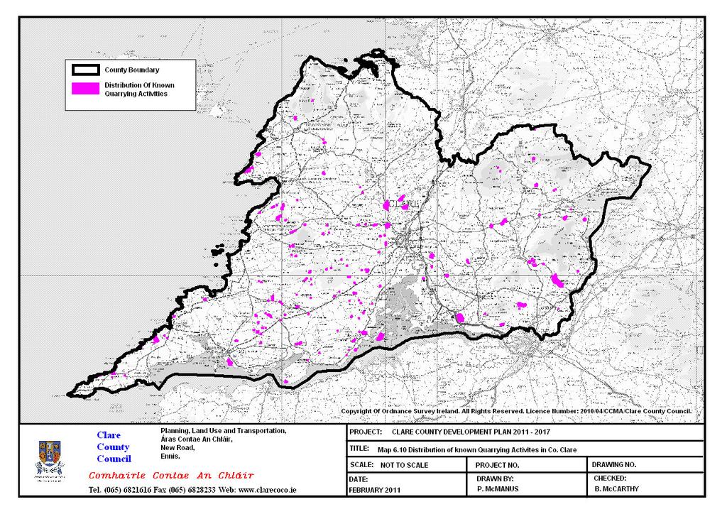
112
113 Environmental Parameter Baseline of County Clare 6.7: Water 6.7.1: Introduction This Section discusses water, i.e. surface water (rivers and lakes, transitional (estuarine) and coastal waters) and groundwater in County Clare. Flooding is also dealt with in this Section. Wastewater and water supply may be referred to in this section but will primarily be dealt with in Section Material Assets in this Chapter : Surface Water County Clare has a significant number of rivers, lakes and turloughs. The main rivers within and surrounding the County are the River Shannon and River Fergus. The Shannon and Fergus estuaries together form the Country s largest estuarine complex. Both rivers have a significant number of tributaries. Lough Derg in the east of the County is the largest lake on the River Shannon. Since 2000, Water Management in the EU has been directed by the Water Framework Directive (WFD) 2000/60/EC which was transposed into Irish law under the European Communities (Water Policy) Regulations 2003 (S.I. No. 722/2003). This Directive requires all Member States to protect and manage their water resources based on the natural geographic boundaries, i.e. the river catchment or basin. The WFD establishes a common framework for the sustainable and integrated management of all waters covering groundwater, inland surface waters, transitional waters and coastal water. Under this Directive Member States must keep a Register of all the water bodies that require extra controls on their quality by virtue of how the water is used by people and by wildlife. In order to achieve good status and to protect our good and high quality waters, the provisions of the WFD, are implemented through River Basin Management Plans (RBMPs). For administration, the plans are implemented on a River Basin District basis. County Clare is divided between the Western River Basin District (WRBD) and Shannon International River Basin District (SIRBD), with approximately 95% of the County within the Shannon IRBD. The Shannon IRBD also includes coastal parts of Clare and Kerry, which drain to the sea. Shannon IRBD is the largest RBD in the Country, covering an area of 18,000km 2. The key objectives of this Directive for the Shannon International River Basin District are aimed at: Maintaining high status of waters where it exists; Preventing any deterioration in the existing status of waters and; Achieving at least good status in relation to all waters in the Shannon IRBD by Similar management plans are developed for the other 6 river basin districts throughout Ireland and for all river basins districts across the EU. There are 5 Water Management Units in County Clare (Map 6.11). Four of these are within the Shannon River Basin District these are Lough Derg WMU, Fergus WMU, West Coast Clare WMU and South Clare/Shannon Estuary WMU. The Kinvarra WMU is in the Western River Basin District and includes an area in the north of the County. Water Management Units group river waterbodies in the County according to their river main catchments and receiving waters. This gives some order and logical when devising action plans for the implementation of programmes of measures and objectives, and, provides for a reporting structure to Europe. There are action plan developed for all WMU in the County. In 2005, all waterbodies were assessed and given a score based on the likelihood of achieving the key WFD objective. Maps , 6.13 and 6.14 show the principal surface waters and their WFD status in the County. Between 1998 and 2007 the main programme in Ireland for improving water quality in our surface waters was the Phosphorus Regulations. This involved the establishment of baseline data for many of 24 Updated as per EPA submission recommendation June
114 Environmental Parameter Baseline of County Clare our rivers and lakes, set out water quality targets to reach and a programme of action whereby the Local Authority would aim to achieve these targets and bring about improvements. The assessment of water quality was discerned through biological quality data using the biological quality index or Q values (Q1(seriously polluted) to Q5(pristine)) or through the measurement of phosphorus levels in the waters where a specific number of samples were required at a certain sampling frequency. Since the adoption of the Water Framework Directive 2000 and its implementation into Ireland through the European Communities (Water Policy) Regulations, 2003 the area of water quality has come into a new management regime whereby management is based on river basin districts and encompasses all waters for improvement including rivers, lakes, groundwater, transitional water and coastal water. New quality standards have been set for surface waters under the European Communities Environmental Objectives (Surface Waters) Regulations, 2009 and for groundwater under European Communities Environmental Objectives (Groundwater) Regulations, Monitoring programmes for surface waters in County Clare have been set up and commenced in 2007 for rivers and lakes. There are 31 river sites and 10 lakes monitored by Clare County Council. These results are reported to the EPA through the Environmental Data Exchange Network (EDEN) and used along with other data to determine status of water bodies in the County and shows trends in water quality. The groundwater and transitional monitoring programmes are carried out by the EPA and the coastal monitoring programme carried out by the Marine Institute. There are 156 river water bodies in County Clare and have been assigned status of which: 34 High Status 21.8% 48 Good Status 30.8% 32 Moderate Status 20.5% 42 Poor Status 26.9% 0 Bad Status 0% This translates to 52.6% of river waterbodies meeting WFD objective of having at least good status, with 47.4% currently failing to meet good status. Of the many lakes in the county there are 37 with water quality data and have been assigned status of which: 10.8% High Status 21.6% Good Status 62.2% Moderate status 5.4% Poor status 0% Bad status Of the transitional and coastal waters there are 33 bodies assigned status of which: 9.1% High Status 27.3% Good Status 21.2% Moderate status 0% Poor status 0% Bad status 42.4% Unassigned (pending data) Where waterbodies are at less than good status the objective is to restore water quality. Where high or good status exists the objective is to protect and maintain status. In any event there must be no deterioration in water quality allowed to occur in any waterbody. There are 11 Designated Bathing Waters identified in County Clare (Map 6.15) in accordance with the Bathing Water Quality Regulations 2008 (S.I. No. 79 of 2008). The Local Authority must monitor for microbiological parameters during bathing water season, which runs from 1 st June to 15 th September in any year. Under the 99
115 Environmental Parameter Baseline of County Clare Regulations, a Bathing Water Profile must be prepared for each designated bathing waters, no later than 24 th March These profiles identify the catchment of a bathing water and the various pressures that may impact or affect water quality particularly in terms of microbial loading which could lead to impacts to human health. Through assessment of data derived from the Local Authority s monitoring programme, the EPA will then give the bathing water a classification which describes the bathing water quality status. All bathing waters must achieve at least the sufficient status classification. However, all Local Authorities must strive to achieve a good or excellent status classification. There are 5 designated Shellfish Waters in County Clare (Map 6.16), namely Aughinish Bay, Poulnaclogh Bay (part of Ballyvaughan Bay), Poulnasharry Bay, Carrigaholy Bay and Rinnevella Bay. These were designated under the European Communities (Quality of Shellfish Waters) (Amendment) Regulations 2009, S.I. No. 55 of This designated an additional 49 water bodies in Ireland from a previous 14 that had been designated under the Shellfish Directive 79/923/EC. This Directive was implemented into Irish Law under the European Communities (Quality of Shellfish Waters) Regulations 2006 (SI No 268 of 2006). The purpose of the Directive is to protect and improve shellfish waters in order to support the growth and production of shellfish (bivalve and gastropod molluscs) and their habitats. Shellfish includes oysters, mussels, scallops, cockles and clams. Shellfish Flesh is sampled and monitored by the Sea Fisheries Protection Authority Department of Agriculture, Fisheries and Food the results of which can classify shellfish waters in terms of quality according to the levels of specific parameters found. In order to improve and/or protect water quality in these water bodies, Pollution Reduction Programmes (PRP) for all designated shellfish waters were developed in December 2009 by the DEHLG in compliance with Section 6 of the European Communities (Quality of Shellfish Waters) Regulations 2006 and Shellfish Directive 2006/113/EC. Under these regulations, local authorities are a prescribed body tasked with implementation of the PRPs, which are also regarded as sub-basin plans under the relevant River Basin Management Plans, for the improvement and protection of shellfish waters. Shellfish Waters are regarded as protected areas under the WFD and are prioritised as regards improving and protecting water quality. The aim of the PRP is to identify pressures and potential pressures within the catchments of shellfish production areas and by the implementation of existing legislation, minimise these impacts and thereby improve and protect water quality to ensure that compliance limits of Schedule 2 of S.I. 268 of 2006 can be met. This fulfils objectives of the WFD, serves to protect the shellfish production industry and human health. The PRPs that were developed and published by DEHLG in 2009 sets out a characterisation of the shellfish waters and their catchments in order to identify pressures in conjunction with natural and anthropogenic conditions. Of the 5 Designated Shellfish Waters in the County two are within the Western River Basin District Aughinish and Ballyvaughan/Poulnaclogh, with the rest situated within the Shannon River Basin District. There is one designated Salmonid Water in County Clare (Map 6.16) as prescribed under the European Communities (Quality of Salmonid Waters) Regulations, This is the River Fergus main channel. According to these Regulations, Salmonid waters must meet water quality standards that are set out in the second schedule of the Regulations. These standards are set to ensure that water quality is such as to support salmonid fish life Salmon (Salmo salar), Trout (Salmo trutta), Char (Salvelinus) and Whitefish (Coregonus). According to the Salmonid Regulations, Salmonid waters must be sampled once per month as is the case with the River Fergus. This data is then submitted to the EPA. There are nine sampling locations along the Fergus River that Clare County Council monitor under these Regulations. County Clare has one waterbody which is designated under the EC Environmental Objectives (Freshwater Pearl Mussel) Regulations 2009 (Map 6.17). The purpose of these Regulations is to support the achievement of favourable conservation status for the freshwater pearl mussel. The Regulations require, inter alia, the production of sub-basin management plans with programmes of measures, for all designated water bodies to achieve these objectives. The catchment area of the Cloon River is 59km2. 100
116 Environmental Parameter Baseline of County Clare The river is listed as 15 th (in status terms) out of 27 in Ireland. There is currently a draft Freshwater Pearl Mussel Sub-Basin Management Plan for the Cloon River. This sets out a programme of measures that must be implemented into the catchment of the Cloon River to improve water quality and conditions so as to promote population growth in pearl mussels and achieve a favourable conservation status. The pearl mussel Margaritifera margaritifera (L., 1758) is protected under several tiers of International and National legislation: The Wildlife Act, 1976 and Wildlife (Amendment) Act, 2000 (The pearl mussel was given protected faunal species status under The Wildlife Act, 1976 (Protection of Wild Animals) Regulations, 1990, S.I. No. 112, 1990) The Habitats Directive (Council Directive 92/43/EEC on the conservation of natural habitats and of wild fauna and flora) as transposed by the European Communities (Natural Habitats) Regulations, S.I. 94/1997, as amended by S.I. 233/1998 and S.I. 378/2005.The pearl mussel is listed on Annex II and Annex V to the Directive, Bern Convention Appendix 3 The freshwater pearl mussel Margaritifera margaritifera (L., 1758) is also on the following red data lists: IUCN Red Data List as Endangered (IUCN, 1996) Red Data (Ireland) as Critically Endangered (Moorkens, 2006) 6.7.3: Groundwater Groundwater is defined as the water stored underground in formations of saturated rock, sand, gravel, and soil. Surface water and groundwater are intimately linked to each other within the hydrological cycle, and groundwater is an important source of water for rivers, streams, and lakes. Thus, the protection of groundwater quality from the impact of harmful human activities is a high priority, as resources are susceptible to pollution with long term consequences both for humans and the natural environment. The Geological Survey of Ireland (GSI) rates aquifers according to their vulnerability to pollution. Aquifer vulnerability refers to the ease with which pollutants of various kinds can enter underground water. Map 6.18 highlights areas of extreme to low vulnerability. A large area in the County is rated as being of extreme and extreme (Rock Surface or Karst) vulnerability. In West Clare beyond a line running from Doonbeg to Kilrush and as far west as Cross the vulnerability is classified as low with pockets of extreme along the west coast from Loop Head to Doonbeg. Map 6.19 shows the WFD groundwater status in County Clare. There are 36 Groundwater bodies in the County assigned status of which: 0% High Status 75% Good Status 0% Moderate status 25% Poor status 0% Bad status 6.7.4: Flooding The Planning System and Flood Risk Guidelines (2009) state that: Flooding is a natural process that can happen at any time in a wide variety of locations. Flooding from the sea and from rivers is probably best known but prolonged and intense rainfall can also cause sewer flooding, overland flow and groundwater flooding. When it impacts on human activities, it can threaten people, their property and the environment. Assets at risk can include housing, transport and public service infrastructure, and commercial, industrial and agricultural enterprises. The health, social, economic and environmental impacts of flooding can be significant and have a wide community impact. There is an increased risk of flooding due to development, climate change and rainfall patterns. The findings of the 2005 EPA report Climate Change: Regional Climate Model Predictions for Ireland (Mc Grath et al., 2005) estimates that future river 101
117 Environmental Parameter Baseline of County Clare discharge will increase by up to 20% in the winter months of December and January in the region, while there is also some evidence of an increase in the frequency of extreme precipitation events. This will have implications for an area already prone to flood events. An in-house flood risk assessment was carried out based on records and interviews with Clare County Council engineers (Map 6.20). A Strategic Flood Risk Assessment (SFRA) was also carried out for the Clare County Development Plan (Map It provides a broad, County-wide SFRA and reflects the broad and strategic nature of the Development Plan. This assessment is similar in some respects to a Regional Flood Risk Appraisal as set out in The Planning System and Flood Risk Management Guidelines for Planning Authorities (OPW, 2009). It includes a broad overview of the sources and significance of flooding across the County and is based on the Flood Zone approach defined below. Clare County is vulnerable to flooding from a number of flood hazard sources: Fluvial flooding from rivers. Pluvial flooding resulting from rainfall that is unable to be absorbed by the ground or drainage system. Coastal flooding from tidal surge. Groundwater, particularly in Karst areas such as the Burren. Urban and suburban flooding caused by surcharge of sewers and drainage systems. Canal, reservoir or embankment breach. The location of flood hazard in the County has been mapped through the specific investigation of two sources of flood hazard. The two sources are coastal flood hazard from tidal surge, and fluvial flood hazard from rivers. The sources should be viewed in isolation and do not account for joint probability issues. The Planning Guidelines define flood hazard through the following zonal classification: Zone A High probability of flooding: >1% probability for river flooding, >0.5% for coastal flooding Zone B Moderate probability of flooding: 1% to 0.1% probability for river flooding, 0.5% to 0.1% probability for coastal flooding Zone C Low probability of flooding: <0.1% probability A probability of 1% corresponds to an average return period of 1 in 100 years, similarly 0.5% is 1 in 200 years and 0.1% is 1 in 1000 years. For County Clare the mapping shows: Moderate (Zone B) and high (Zone A) probability of flooding, of limited extent, associated with numerous river rivers in the County. Moderate (Zone B) and high (Zone A) probability of flooding associated with certain stretches of the County s coastline and tidal estuaries. The flood risk zones are overlaid on the County settlement strategy map to provide a composite map (Map 6.21). This identifies the location of coastal and fluvial flood risk in relation to the settlement strategy. Preliminary analysis indicates: Location of most settlements in the County on or near rivers and floodplains. Limited extent of areas at risk of flooding for most settlements. Clustering of historical flood events : Existing Environmental Problems Water pollution is an important issue in the County for both its inhabitants and its wildlife. This presents significant challenges in terms of appropriate land use and the long term protection of vulnerable resources. Pressures on water bodies have a variety of sources including domestic, industrial, agricultural uses, and development. Water runoff and wastewater treatment plant discharges are the likely cause for the deterioration of water quality, e.g. one-off housing and its impacts on surface and groundwater with relation to septic tanks and percolation areas. Developments and their impact on watercourses, with the removal of floodplain storage may result in lack 102
118 Environmental Parameter Baseline of County Clare of permeable areas to mitigate the likely impact of runoff and future water level consistency (particularly re freshwater bodies). Areas within the Shannon IRBD have one of the highest proportions of waterbodies across all water types at risk from pressures. The most significant pressures on these waterbodies are; diffuse pollution sources particularly from urban and agricultural land use; and, morphological alterations particularly channel drainage associated with rivers, impoundments on lakes and activities associated with ports in transitional and coastal waters. Groundwater quality is influenced by surrounding geology and as stated is prone to pollution from external sources. Once polluted it is extremely difficult to remedy so prevention is always advised. Groundwater reserves are a valuable source of water supply at present but particularly for future domestic use, industry and agriculture uses, and it also performs an important role in sustaining the base flows in the County especially the River Shannon, River Fergus and their tributaries. Principal water pollutants have been identified as on-site treatment systems and agricultural runoff. In certain cases, poorly managed areas of forestry have caused pollution of waters. One-off dwellings in un-serviced areas and their reliance on on-site treatment systems are of concern particular where there is an over concentration of such systems, especially in groundwater dependent areas. There are also certain areas where onsite systems may not be appropriate due to soil type or shallow depth of soil. There is an increased risk of flooding due to development, climate change and rainfall patterns. Development can exacerbate the problems of flooding by accelerating and increasing surface water runoff, altering watercourses and removing floodplain storage. It is now recognised that flood risk management must be treated as a central issue in the development of the County. Floodplains have, therefore, a valuable function in attenuating and/or storing floodwater and through their ability to convey floodwater in a relatively controlled and safe way. Areas of floodplain and wetlands should therefore be recognised and preserved as natural defences against flood risk : Evolution of Water in the absence of the CCDP Legislation and guidance documents at European and National level protect and maintain existing waterbodies in the County. However, in the absence of the Clare County Development Plan there would not be a framework within which to regulate, aid and/or control development whether economic, social or environmental. The baseline information for County Clare has highlighted that a number of waterbodies are under pressure from various sources of pollution. Diffuse sources of pollution and morphological processes within the rivers and lakes have been identified as the main causes. Furthermore, based on the current risk assessments in the Shannon and Western RBD characterisation reports a number of waterbodies are at significant risk of failing to meet the requirements of the Water Framework Directive by If existing wastewater treatment facilities are currently close to or at maximum capacity, future development in the absence of the Clare County Development Plan would have a negative effect on the water quality of the entire County and other Counties. However, this issue would not be evenly spread throughout the County and certain areas would have greater water quality issues than other areas. If new and uncontrolled development is not accompanied by appropriate wastewater infrastructure/capacity then it is most likely that surface and groundwater bodies would fail to meet the objectives of the Water Framework Directive by 2015; and there would be significant adverse direct and indirect impacts, etc. on water and the other environmental parameters in the County to varying degrees. For example, human health would be directly adversely affected as a result of poor water quality. Furthermore, in the absence of the Plan, Sustainable Drainage Systems (SuDS) could not be implemented, thus surface water run-off due to uncontrolled development would be discharged directly into the groundwater system. The cumulative effects of such run-off have the potential if combined with other factors, e.g. severe rainfall, to result in flooding. Biodiversity would be exposed and vulnerable to a direct loss of 103
119 Environmental Parameter Baseline of County Clare species types and numbers, and tourism could indirectly suffer if lake and beaches in the County suffered reduction in their water quality status. 104
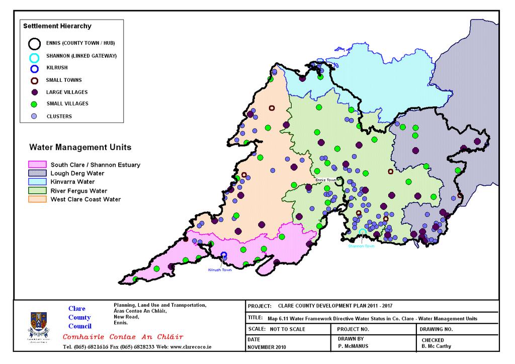
120
121
122
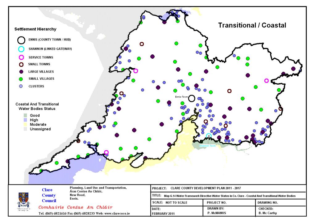
123
124
125
126
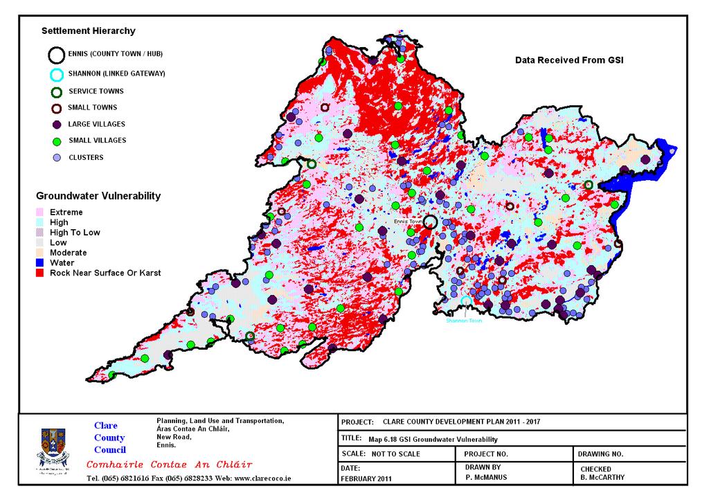
127
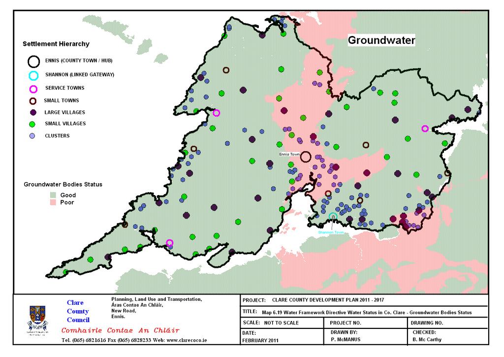
128
129
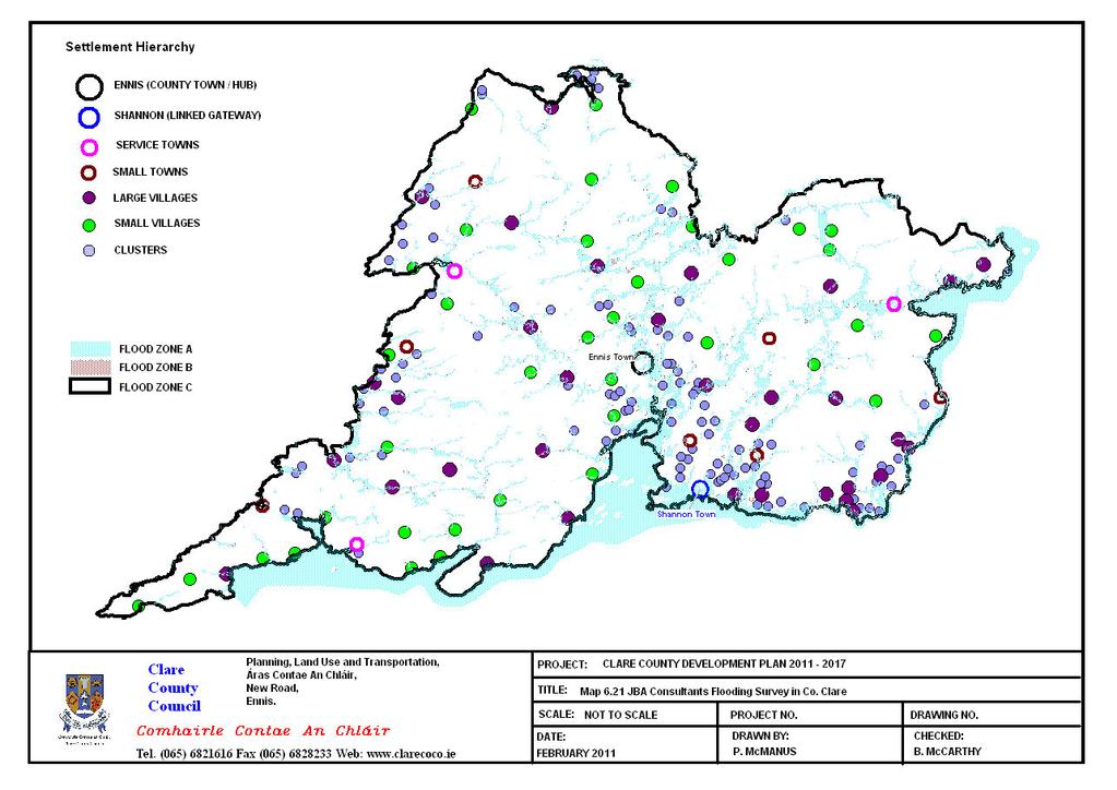
130
131 Environmental Parameter Baseline of County Clare 6.8: Air and Climate 6.8.1: Air Quality Air quality monitoring in Ireland is undertaken largely to implement EC Directives on smoke and sulphur dioxide (SO 2 ), lead, ozone (O 3 ) and nitrogen dioxide (NO 2 ) and to assess compliance with national air quality standards. The Environmental Protection Agency has become involved in air quality monitoring and have installed a number of air quality monitoring stations throughout Ireland, with one located within Ennis, i.e. a mobile unit which is the only monitoring station in the County. Ireland is divided into four zones for the purpose of monitoring. Ennis is in Zone C, with the remainder of the County in Zone D. O 3, NO 2, SO 2 and Pm10 (particulate matter with diameter less than ten microns) are measured in Zone C. The EPA report entitled Air Quality in Ireland 2006 Key Indicators of Ambient Air Quality notes that the highest concentrations of SO 2 at 11 stations nationwide were recorded in Ennis and Wexford, two of the smaller Zone C towns. The report concludes that this is most likely due to burning of coal and other solid fuel. Also the report discusses PM10 stating that PM10 levels were similar to those measured in 2005, and all stations were compliant with the 2005 limit value which permits no more than 35 exceedances greater than 50 μg/m 3. The highest PM10 was also recorded in Ennis and Wexford, two of the smaller Zone C towns. The report also concluded that this is most likely due to burning of coal and other solid fuel. In 2007, the highest PM10 levels were recorded in Ennis and two other towns in Ireland, again this was most likely due to burning of coal and transport emissions. With the exception of PM10, all other parameters measured for Zone D were beneath the lower assessment threshold. Five categories are used to describe air quality information. These categories are: Very good, good, fair, poor and very poor. The index is based on a maximum of four parameters; the one-hour average of SO 2, NO 2 and O 3, combined with the rolling 24- hour average of PM10. The index rating for overall air quality in Zone C, derived from results from the Ennis station which includes all of the Plan area, is good. Air quality is also tested at nearby Shannon Estuary, at Askeaton and County Limerick, classified Zone D (this area includes rural sections of the Country). Currently, the air quality there is very good. The quality of air at Shannon airport is monitored at 6 monthly intervals in three strategic locations over continuous 10-day periods. The monitoring programme collects a range of data for a number of prescribed parameters, which are then compiled in a detailed report for review by the Safety and Environmental Department. There are Integrated Pollution Prevention and Control licensed activities in the County (see Map 6.22 and Table 6.10). The most notable one is the ESB power station at Moneypoint and the remainder of these licensed activities mainly located in Shannon. 25 Updated as per EPA submission recommendation June
132 Environmental Parameter Baseline of County Clare Table 6.10: Integrated Pollution Prevention and Control Sites in County Clare Facility IPPC No. Location Principle Activity Roche Ireland Limited P Clarecastle, County Clare, Clare Chemicals Schwarz Pharma Limited P Shannon Free Zone, Shannon, County Clare, Clare. Chemicals Finsa Forest Products Limited P Scarriff, County Clare, Clare : Wood, Paper, Textiles and Leather Essidev S.A. Trading As Organic Lens P Gort Road Industrial Estate, Ennis, County Clare, Clare. Chemicals Manufacturing Shannon Aerospace Limited P Shannon Airport, Shannon, County Clare, Clare : Surface Coatings Devcon Limited P Shannon Industrial Estate, Shannon, County Clare, Chemicals Clare. Chemifloc Ltd. P Smithstown Industrial Estate, Shannon, Co. Clare, Chemicals Clare. Saint-Gobain Performance Plastics Ireland P Kilrush, County Clare, Clare Surface Coatings Heraeus Metal Processing Limited P No. 75, Shannon Industrial Estate, Shannon, Co Clare, Metals Clare. Molex Ireland Limited P Shannon Industrial Estate, Shannon, Co. Clare, Clare. Surface Coatings Galvotech (International) Limited P Smithstown Industrial Estate, Shannon, Co. Clare, Surface Coatings Clare. Shannonside Building Supplies Limited P Fort Road, Kilrush, Co. Clare, Clare. Wood, Paper, Textiles and Leather Lufthansa Technik Painting Shannon Limited P Shannon Airport, Shannon, County Clare, Clare. Surface Coatings Element Six P Bay 371, Shannon Industrial Estate, Shannon, County Mineral Fibres and Glass Clare, Clare. Electricity Supply Board (Moneypoint) P Moneypoint Generating Station, Killimer Kilrush, County Energy Clare, Clare. Clogrennane Lime Limited P Toonagh Quarry, Ennis, County Clare, Clare. The production of lime in a kiln. 117
133 Environmental Parameter Baseline of County Clare 6.8.2: Climate Change Climate Change is a transboundary issue affecting the entire globe and is fundamental to social stability and sustainable development. It is widely recognised that the build up of atmospheric Greenhouse Gases (GHG s) such as carbon dioxide is threatening global climate stability. Most GHG emissions are related to the energy generation, transport, agriculture, and industry sectors. Ireland ratified the UN Framework Convention on Climate Change in 1994 and the Kyoto Protocol in Following the Conference of Parties to the Climate Change Convention meeting in Copenhagen, 2009, the EU revised its commitment to reducing greenhouse gases by increasing the target to 20% reduction on 1990 levels by The transport sector in County Clare presently accounts for 42% of all energy use in the County, and produces 452,000 tonnes of CO 2. The Limerick Clare Energy Agency (LCEA) estimates that energy needs in the County are set to double from 1990 levels to Two key actions required under the LCEA Regional Climate Change Strategy are to reduce the use of fossil fuels and to increase our renewable energy resources. The Limerick Clare area is unusual in that it has a number of large energy producers and consumers namely: i. Moneypoint electricity largest energy generating station ii. Aughinish Alumina, large energy consumer and soon electricity producer (CHP) iii. Irish Cement Ltd, large energy consumer iv. Shannon airport, large energy consumer These four sites have been estimated to be responsible for over 12,300,000 tonnes of CO 2 per annum. All these sites except Shannon Airport are dealt with under the National Emissions Trading Scheme. Oil is the predominant fuel used in the area and it counted for 58% of all CO 2 emissions in At a regional level, the Limerick Clare Climate Change Strategy 2006 identifies that achieving sustainability for the Limerick and Clare region depends upon securing a supply of energy. The amount of energy currently being produced and consumed in the region must be identified and the environmental implications associated with the consumption of the energy must be assessed relative to National and International obligations as outlined in the National Climate Change Strategy A Clare Climate Change Strategy was published in The strategy set out to address the local delivery of National policy. The Mid-West Climate Change Strategy 2007 and Action Plan and the ongoing publications of the Limerick Clare Energy Agency (LCEA) have set out local sectoral objectives and issues relevant to their achievement (see Table 6.11). Table 6.12 and Figure 6.3, shows that County Clare s energy consumption and CO 2 emissions are higher than the National average. To enable the County to develop a low carbon economy it is important that everybody in Clare reduces their CO 2 emissions by 5.2 tonnes per annum. This can be achieved through employing energy conservation methods and increased energy efficiency in buildings and utilising alternatives sources of energy. The challenge of addressing climate change can present many opportunities. The development of a low carbon economy and society has been identified as a significant opportunity to create many jobs in clean energy technologies. County Clare has a long and proud tradition of producing reliable and secure energy resources for the nation. The County is very well placed to develop this tradition, making a significant contribution to reducing Ireland s energy related CO 2 emissions and creating employment. The findings of the Limerick Clare Climate Strategy indicate that County Clare will produce approximately 1.4 million tonnes of CO 2 in When contrasted with the level in %, County Clare exceeds the 2010 target by 489,000 tonnes. Since the publication of the Mid West Regional Climate Change Strategy there have been two important documents:- 1. Mid West Regional Biomass Action Plan, MWRA, County Clare Wind Energy Strategy

134 Environmental Parameter Baseline of County Clare Table 6.11: Energy Related CO 2 Reductions Sought in County Clare 000 Tonnes CO 2 Clare Energy Production & Supply* * Transport Built Environment Industry/Commercial Services Agriculture Waste Total Source: Mid West Regional Climate Change Strategy, 2008, MWRA Table 6.12: County Clare s Energy Consumption and CO 2 emissions Indicator Ireland Clare Ireland Clare Ireland Clare Population (000) 3, , , Energy Related Emissions (ktt- CO 2 ) 31, , , ,206.9 CO 2 Emissions / Capita (T CO 2 / Inhabitant) Source: Clare Climate Change Strategy, 2006, LCEA Figure 6.3: Energy Consumption in County Clare Source: Limerick Clare Energy Agency The MWR Biomass Action Plan identifies the potential for development of biomass for heat and electricity generation in the region and the County. The action plan identifies that County Clare will need financial stimulus to enable it to meet the 12% target for heat from renewable energy by However, County Clare does have the renewable biomass resources (forestry) necessary and if those resources are harvested for heat the CO 2 reductions would be 51,000 tonnes. However, under the White Paper on Energy (DCENR, 2007), it is expected that Moneypoint power station will commence co-firing with biomass in Trials have been conducted and the plant may co-fire at rates up to 20% biomass (20% of energy input by biomass). Should Moneypoint power station co fire the reductions in CO 2 emissions would be significant: 5% biomass co-firing would reduce plant CO 2 emissions by 257,000 tonnes per annum 10% biomass co-firing would reduce plant CO 2 emissions by 514,000 tonnes per annum 20% biomass co-firing would reduce plant CO 2 emissions by 1,028,000 tonnes per annum 119
135 Environmental Parameter Baseline of County Clare The County Clare Wind Energy Strategy has identified areas of the County where the wind resources and electricity infrastructure can be harnessed to meet an initial target of 550 MW. This strategic approach to renewable electricity generation is the first to be published in Ireland and will enable key strategic energy resources to be developed, and if the target of 550 MW is reached the reduction in CO 2 emissions would be 1,000,000 tonnes per annum. County Clare imports over 90% of its energy needs. This is wholly unsustainable for a County to depend on external resources for its energy requirements. County Clare has however the capacity to generate energy without depending on conventional resources. Renewable energy resources such as wind, tidal, wave, hydro and biomass are readily available in Clare but are under utilised. Recent developments have shown that strategic approaches to heat and electricity generation can make substantial contributions to the County s energy, economic and social security. Over 2,000,000 tonnes of CO 2 reductions are possible, making significant contributions to our Kyoto commitments and Climate Change. The SFRA mapping for the County took account of sea-level and climate change scenarios : Existing Environmental Problems Whilst Ireland generally does not have a significant outdoor air quality problem the biggest threat is emissions from road traffic. According to the Limerick Clare Energy Agency, the greatest energy consumers and producers of CO 2 in County Clare are the energy production and transport sectors. Some strategic solutions to CO 2 reductions in the energy production sector have been outlined above. The transport sector has emerged as the sector with the next greatest share of energy consumption. Correspondingly, this sector also shows the highest increase in the level of emissions since 1990 with a 143% increase to This trend is set to continue unless GHG emissions are strongly targeted. In County Clare, CO 2 reductions per capita of 4.7 tonnes are required. Overall, road traffic has now become the greatest source of air pollution generally. In urban areas, concern has clearly shifted to a range of pollutants associated with this source which may be considered relatively new in the context of air quality control. The most important of these pollutants are NO 2, PM10, CO and a wide variety of VOC, including carcinogens such as benzene. Advances in engine technology and fuel development will, it is predicted, offset any rise in tail pipe emissions from increased car usage due to an increased population. The majority of the Plan area is rural in nature where travel is an essential part of daily life. Agriculture is changing and is likely to change further with the ongoing discussions on the mid-term review of the Common Agricultural Policy (CAP). The outcome of the review is unknown, so too are the consequences for the national herd, directly related to methane production. Land use changes can and will have far-reaching implications for climate change that could include sweeping changes to commuter patterns with the building of more one-off houses in rural areas (also influenced by government policy such as the Guidelines for Sustainable Rural Housing) and the resultant increase in GHGs, SO 2, NOx, VOC and other pollutant emissions : Evolution of Air and Climate in the absence of the CCDP In the absence of the CCDP there would not be a framework within which to regulate, aid and/or control development whether economic, social or environmental. Energy conservation objectives and potential for renewable energy may not be realised, thus the County would not be contributing to achieving the overall national targets under the Kyoto Protocol. Development would have no policy regulation or guidance over where it could occur or what construction standards and energy regulations should be achieved. This could lead to non-strategic developments in isolated areas resulting in significant increases in population, increase in car usage and therefore increase in emissions causing air pollution and the associated knock-on effects on human health. Air pollution would impact on the health of sensitive populations or groups and eco systems. In the absence of the Plan sustainable mobility objectives may not be implemented thus the transport sector which is a great energy consumer could not be monitored. Specific 120
136 Environmental Parameter Baseline of County Clare issues associated with climate change such as sea-level rise, extreme flooding and drought, changes in species distribution would continue unchecked and lead to catastrophic consequences, for example, continued and increased flooding, significant risk to human quality of life, property, biodiversity, agriculture productivity and water quality. Furthermore, the cumulative effects of individual developments would not be easily overseen or coordinated and assessed for their effects. 121
137
138 Environmental Parameter Baseline of County Clare 6.9: Material Assets 6.9.1: Introduction The EPA SEA Process Draft Checklist (2008) defines material assets as the critical infrastructure essential for the functioning of society such as: electricity generation and distribution, water supply, wastewater treatment, transportation, etc. Thus this Section will discuss the following: 1. Transportation (largely car-based) Waste Management 3. Water Supplies 4. Wastewater Treatment Infrastructure 5. Renewable and Alternative Energy 6.9.2: Transportation Due to the position of County Clare on the western seaboard with an International Airport, deep water estuary, railway and high quality Motorway, National, Regional and local road networks, the County has a significant strategic transportation infrastructure within the Mid-West Region. The Limerick/Shannon area is designated as a Gateway under the National Spatial Strategy. Gateways are strategically located both nationally and relative to their surrounding areas. Such centres provide nationalscale social, economic infrastructure and support services. Further development of these Gateways is a key component of the National Spatial Strategy. Shannon International Airport is a critical element in the National transport infrastructure, not only to the County but to the wider region. It is a key access gateway for the region and connects the West of Ireland to other European and International destinations. The designation of Ennis as a Hub town has brought forward improvements in transport infrastructure, including the construction of the Ennis bypass and Ennis western relief road, and the improvement of the Ennis to Limerick railway line. The road network in the County is made up of Motorway, National Primary Road, National Secondary Roads, Regional Roads and Local Roads. Map 6.23 outlines the Motorway, National and Regional roads, while Table shows the category of roads in the County and their corresponding lengths. Table 6.13: Category of Roads and their corresponding Lengths in County Clare Category of Roads Length Motorway 31.62km National Primary Roads 56km National Secondary Roads 187km Regional Roads 620km Local Roads 3,399km* Total Length 4,293.62km *The Local Road Map may be revised in due course as some roads that were taken in charge in recent years have yet to be added to the system The Motorway, National primary and secondary roads play a pivotal role in providing ready access to all regions of the County. They link the County with the adjoining Region and their Gateways, provide direct access to Shannon International Airport, and to the regional rail network and to ports. The County is serviced by two main National Primary Routes the N18 Galway-Limerick and the N19 which branches off the N18 towards Shannon Airport. National secondary routes provide medium distance through-routes connecting main towns. The National Secondary Routes in Clare consist of the N85 Ennis-Inagh- Ennistymon, N67 Killimer-Kilrush-Lahinch-Ballyvaughan and N68 Kilrush-Ennis. A series of Regional roads run through the County. These roads provide an important function in linking the smaller towns and villages with the larger urban centres and 26 Inserted as per EPA recommendation June Table 6.13 linked to Map 6.23 as per EPA recommendation June
139 Environmental Parameter Baseline of County Clare with the national primary and secondary routes. Table 6.14 lists Proposed Projects Identified for Future Development of significant scale in County Clare. 80% of the road network in Clare is classified as local roads. Local roads are divided in to Local Primary Roads, Local Secondary Roads and Local Tertiary Roads. The local roads of the County provide mobility links to the regional roads and national routes within the County. The road network of national and regional roads is shown in Map Table 6.14: Proposed Projects Identified for Future Development Northern Limerick Distributor Road (Knockalisheen) providing linkage and access to UL campus between Coonagh and the N18 and the N7 main Dublin road north of the University of Limerick. Western By-Pass of Killaloe Shannon Crossing South of Killaloe Realignment of sections of N85 Ennis Ennistymon Kilkee lower ring road linking the N67 at Kilkee Bay Hotel, running west to the Carrigaholt road, linking with the coast road. Sixmilebridge Inner Relief Road Rail services in the County are provided by a branch off the Limerick line, and serving Ennis. The upgrading of the Ennis to Limerick railway and the provision of a more frequent service has led to a substantial increase in passenger numbers. The Planning Authority has designated an area of land for a new station and park and ride facility at Clarecastle. This location is within a few minutes drive of a substantial part of the Ennis area using the new N18/N85 road network. A recently achieved objective of Transport 21 was the re-opening of the Western Rail Corridor. This project has upgraded the rail service provided in the County and involved upgrading of 36 miles of track and associated infrastructure, plus the provision of five stations at Gort, Ardrahan and Craughwell (on the Ennis/Athenry section), Sixmilebridge (on the Limerick/Ennis section) and Oranmore (on the Athenry/Galway section). The County Development Plan supports the provision of a station at Crusheen (CDP 11.9). Capable of accommodating both freight and passenger trains, there are currently 5 services operating between Limerick and Galway cities in each direction. It is hoped that this service will also enhance access to Shannon Airport from other parts of the west of the country. Shannon Airport was the first airport in the world, outside of the Americas, to offer full US Customs and Border Protection (CBP) preclearance facilities to airlines travelling to the USA. It also plans to develop a US cargo preclearance facility and as such Shannon Airport Authority (SAA) proposes that a rail link to the Airport is needed to facilitate this increased cargo capacity. Bus services in the County are mainly limited to long distance routes between Cork, Limerick and Galway from Ennis. A local bus service between Ennis and Shannon Airport stops at a number of points on the Limerick road between and as far as Clarecastle. The bus station at Ennis is being upgraded for both bus and rail passengers. Bus Eireann are currently looking at opportunities to improve their local service. There is a sparse bus service run by Bus Eireann within rural areas of the Plan. There is also a limited community transport service in rural County Clare. The transport of goods and passengers is well established between Clare and the Aran Islands and Clare and Kerry. There are two ferry services operating, from Killimer to Tarbert, Co. Kerry and Doolin to the Aran Islands in Co. Galway. The County also has harbour resources, most notably the deep sea port associated with Moneypoint. The Shannon Foynes Port Company is Ireland s second largest port operation and has statutory jurisdiction over all marine activities on a 500 km 2 area on the Shannon Estuary, stretching from Kerry/Loop Heads to Limerick City : Waste Management The Local Authorities of Clare County Council, Kerry County Council, Limerick City Council and Limerick County Council have adopted the Replacement Waste Management Plan for the Limerick/Clare/Kerry Region for the region which 124
140 Environmental Parameter Baseline of County Clare was assessed under SEA process as will any review document 28. The Waste Management Plan is aimed at securing the best environmental management of waste, including prevention and minimisation where possible and practical, and treat waste produced in the region which includes for the planning, regulation, collection, prevention, recycling, energy recovery, and disposal of wastes in accordance with current National and EU waste legislation and policies. In Clare County, the mass of waste generated per person increased by over 3% to 431kg between 2004 and 2006, this is considerably above the 384kg per person average for the region. Household recycling rates have been growing since 2004 and in County Clare in 2006, 23.6% of household waste was recycled 29. The aim is to achieve a 45% recycling rate by 2011 which is achievable 30. Clare County Council operates one main central waste management facility at Ballyduffbeg in Inagh, two recycling centres in Ennis and Shannon, and two recycling centres, and transfer stations in Lisdeen and Scariff (see Table 6.15). Clare County Council no longer provides a waste collection service. However, private waste collection is regulated by the Local Authority through the waste collection permitting system. There are a number of private waste collectors operating within the County. Collection services are provided by permitted waste collection operators. Construction and Demolition (C&D) has declined in the region by 5.95% between 2002 and The waste management plan noted that the Region has seen little infrastructural development for C&D waste, other than a C&D Waste Recycling Plant operated privately in County Kerry. In total there are 53 Bring Banks throughout the County, which provides an average of 2.64 sites per 5,000 head of population and Clare County Council also operates an annual Spring Cleaning Campaign. Table 6.15: Waste Licenses Issued in County Clare Facility Licence Name Activity No. Doora Landfill Site W Clare County Landfill Council Tradaree Point E.T.P. W Clare County Sludge Treatment Council Facility Enva Ireland Ltd W Shannon Hazardous Waste Trading As Enva Environmental Facility Services Ltd. Central Waste Management Facility, Inagh Scarriff Civic Amenity Centre Lisdeen Recycling Centre & Transfer Station Clean (Ire) Refuse & Recycling Ltd W / W Clare County Council W Clare County Council W Clare County Council W Clean (Ire) Refuse & Recycling Ltd Landfill Waste Transfer Station Waste Transfer Station Materials Recovery Facility 6.9.4: Water Supplies The DoEHLG provides capital funding for new and upgraded water and waste water infrastructure. It does so through a number of programmes. The Water Services Investment Programme (WSIP) goal is to ensure that the timing and scale of water services investment facilitates economic development and other development, compliance with all statutory requirements for drinking water and waste water treatment and the achievement of environmental sustainability objectives. The DoEHLG requires all programmes of investment in infrastructure to prioritise projects that target environmental compliance issues, while supporting economic growth and employment. 28 As per EPA submission recommendation June EPA recommendation to make reference to residential waste and recycling 30 As per EPA submission recommendation June
141 Environmental Parameter Baseline of County Clare The Rural Water Programme (RWP) provides funding for projects up to 1million. Selection and management of projects to be funded by the RWP are devolved to Local Authorities. Group water and sewerage schemes, which are a widespread means of provision of infrastructure in rural areas, are part of the RWP. Clare County Council operates a number of measures to deal with deficiencies in group water schemes, small public water and sewerage schemes and private supplies where there is no existing alternative group or public supply in the area. The Rural Water Programme has two elements: 1) Group water and sewerage schemes, which are a widespread means of provision of infrastructure in rural areas. This includes provision of small private water supplies, including individual bored wells where appropriate, where there is no existing alternative group or public supply in the area. 2) Small public water and sewerage schemes, operated by Clare County Council to deal with local deficiencies in public water and sewerage infrastructure. Clare County Council Assessment of Water Services Needs The DoEHLG require Water Services Authorities to provide an Assessment of Water Services Needs to ensure projects selected for funding are well aligned with National programme priorities. The Assessment of Needs for Clare for the period 2010 to 2012 has been prepared in accordance with Circular L6/09 from the DoEHLG. It is possible for some projects to be included in more than one category, and this is the case for a number of County Clare projects included in the assessment. The Assessment of Water Services Needs is currently done every three years, and therefore such Assessments will be undertaken during the lifetime of the Plan, Clare County Council, as the Water Services Authority for the County, is responsible for providing and maintaining adequate public water supply infrastructure throughout the County and continues to invest in the improvement of existing and development of new water supplies, in accordance with the Water Services Investment Programme and Rural Water Programme. Figure 6.4 illustrates the percentage categorisation of water supply in County Clare and Table 6.16 lists the Water Supply Schemes in County Clare giving the name, source and stating whether the scheme is public or private. Private water supplies provide an alternative for areas that are not served by public water supply infrastructure and comprise mainly of wells for single dwellings and certain private group water schemes for rural clusters and small settlements. The drinking water sources in the County are abstracted from surface water and groundwater. Public supply sources and their associated catchments are listed in an Appendix of the County Development Plan : Waste Water Treatment Infrastructure The safe treatment and disposal of sewerage is fundamental to the sustainable development of our society. The treatment of wastewater is either through wastewater treatment plants or individual septic tank units. Figure 6.5 summarises the percentage by Types of Wastewater Systems in County Clare. Outside of the larger towns and villages within the County, most developments are not connected to a public wastewater disposal system. Effluent disposal is treated by individual proprietary wastewater treatment plants and septic tanks. The majority of development taking place within the rural hinterland is predominantly individual housing developments that require their own wastewater treatment units. Map 6.24 shows the waste water treatment plants in the County. A number of wastewater treatment plants are in operation in close proximity to surface waters in the at risk category which are at significant risk of failing to meeting the objectives of the Water Framework Directive. Developments of single treatment systems for housing developments of 10 houses or less in established villages or clusters will only be permitted where it is demonstrated that such development is in accordance with the EPA wastewater treatment code of practice, that proper management and maintenance arrangements are in place, and there is no threat to the integrity of Natura 2000 sites, NHAs or pnhas. 126

142 Environmental Parameter Baseline of County Clare 6.9.6: Renewable and Alternative Energy This is discussed in the Wind Energy Strategy included as Volume 5 of the Clare County Development Plan Figure 6.4: Water Supply in County Clare Other private source Group scheme 10.5% with private source 6.3% None 0.4% Not stated 3.1% Group scheme with Local Authority source 17.7% Public main 62.0% Table 6.16: Water Supply Schemes in County Clare Supply Scheme Name Source Public/Private Ardtaggle Ardtaggle borehole Public Ballyvaughan Newtown well, Acres Springs Public Bodyke Coolready borehole Private group scheme Bridgetown Bridgetown borehole Public Broadford Crean borehole Public Carron Termon Spring Public Corofin Lough Inchiquin Public Ennis Drumcliffe Springs Public Ennistymon Lickeen lake Public Fanore Caher river Private group scheme Feakle Bauregaun borehole Public Flagmount Lough Graney Public Kildysert Lake Gortglass Public Kilkee Lislanaghan reservoir Public Kilkeady Kilkeady spring Public Killaloe Creevrua and Garraunboy boreholes Public Killone Killone lake/borehole Private group scheme Kilmaley-Inagh Lough Namina Private group scheme Kilnaboy Kilnaboy borehole Private group scheme Lemenagh/Roughan Lemenagh borehole Private group scheme Limerick environs Shannon River Public Lisseycasey Lough acrow, Furoor borehole Private group scheme Lisdoonvarna Lickeen lake and Kilmoon spring Public Milltown Malbay Lough Keagh Public Monreagh/Tubber Monreagh Spring Private group scheme Mountshannon Cloonmirran borehole Public Newmarket on Fergus Castle lake Public O Briensbridge Montpelier borehole Public Ranaghan Lough George Private group scheme Raheen Raheen borehole Private group scheme Scariff Magherareagh borehole Public Shannon Airport Rosroe lake Private Shannon Castle lake Public Sixmilebridge Castle lake Public Toonagh-Dysert Ballycullinan lake Private group scheme Tulla Castle lake and Crean borehole Public Turlough Turlough borehole Public West Clare Doo Lough Public Whitegate Clonoolia borehole Public Williamstown Williamstown well Private group scheme 127
143 Environmental Parameter Baseline of County Clare Figure 6.5: Types of Wastewater Systems in County Clare Other individual 3% No sewerage 1% Other 1% Not stated 3% Individual Treatment System 44% Public scheme 48% 6.9.7: Existing Environmental Problems County Clare is a large geographical area so travel patterns are very much governed by the use of the private car. The County is therefore dependent on an efficient and adequate road network. As such, the maintenance and upgrade of the existing road network and where necessary, the provision of new road networks or realignments of existing roads are essential to ensure that the road network and its carrying capacity are maintained to a high standard. Accordingly, the Council recognise the importance of provision of a safe and efficient road network for users. Transportation is the cornerstone of the Irish economy and will continue to be promoted as an essential component to the further sustainable development of the County. However, the function of the Local Authority is somewhat limited in that the National roads Authority are directly responsible for the national roads network, Iarnród Éireann are directly responsible for the rail network and Bus Éireann and other private operators are responsible for public bus services. However, the Local Authorities have and will continue to liaise with the relevant authorities in enhancing service provision to the inhabitants of Plan area. A downturn in the aviation sector could have negative impacts on the economy of the County. On average, approximately 90% of waste in Ireland is sent to landfill. The average household produces almost 1.5 tonnes of waste a year. This amount of waste can be reduced by prevention, minimisation, reuse and recycling. In fact about half of this waste could usefully be recycled. Recycling reduces the use of raw materials, lowers energy costs and results in less waste going to landfill. The disposal of waste material is an important issue. Limited landfill capacity means that an increasing amount of our household and commercial waste needs to be recycled. Waste Management Plan - The Plan aims to ensure that waste is used as a resource, resulting in a better solution for the people and the environment in the region. Illegal dumping remains a big problem in the County at large and the proposed increases in enforcement activity and staffing will assist greatly in tracking down unauthorised collectors of waste as well as the origins of the dumped material. It is recognised in the Waste Plan that increased public awareness and education would be fundamental to the achievement of these objectives. Other threats which have been outlined in the joint Waste Management Plan include Lack of suitable sites for Bring Banks; No security of supply for Thermal Treatment Facilities; No major Construction and Demolition waste recycling facilities (Also a national issue); and Lack of facilities for treatment of biological waste. There is insufficient wastewater treatment infrastructure in County Clare to serve existing and proposed population. Therefore, there is a need to provide additional wastewater treatment infrastructure/capacity. Poorly functioning septic tanks have 128
144 Environmental Parameter Baseline of County Clare the potential to place pressure on surface and groundwater resources. There are implications however from the operation of both forms of treatment [wastewater treatment plants or individual septic tank units], entailing principally the discharge to the receiving environment. Insufficient treatment has the potential to adversely affect the quality of the groundwater and surface water with significant potential adverse effects on biodiversity and human health and amenity : Evolution of Material Assets in the absence of the CCDP In the absence of the CCDP there would not be a framework within which to regulate, aid and/or control development whether economic, social or environmental. In the absence of the Plan, issues such as future water demand, resource identification and protection will not be comprehensively assessed resulting in a poor level of service provision and possible degradation of important reserves. Also, the future investment in key infrastructure will not be targeted appropriately to key development areas. The result would be a haphazard, un-coordinated delivery of service, resulting in negative environmental impacts. 129
145
146
147 Environmental Parameter Baseline of County Clare 6.10: Cultural Heritage including Architectural and Archaeological Heritage : Introduction This section of the Environmental Report discusses cultural heritage which includes archaeological and architectural heritage : Archaeological Heritage 31 Archaeological heritage is defined as including structures, places, caves, sites, features or other objects, whether on land underwater or in inter-tidal zones. All archaeological structures, constructions, groups of buildings, developed sites, all recorded monuments as well as their contexts, and moveable objects, situated both on land and underwater are part of the Archaeological Heritage. Therefore the archaeological heritage of the area is not confined to the archaeological sites within the Record of Monuments and Places. It also includes any archaeological sites that may not have been recorded yet, as well as archaeology beneath the ground surface, or underwater as well as the context of any such site discovered. County Clare possesses a rich and varied archaeological record covering eight millennia (Map 6.25). There are currently c.7500 monuments in Clare, which is more than most counties in Ireland. Notably, there is little evidence from the earliest period, the Mesolithic, but the Neolithic or New Stone Age and subsequent eras are well represented with many sites and artefacts demonstrating life in Clare for the past 6,000 years. These early farmers left little evidence of their settlements but their territorial/burial monuments survive. Large numbers of megalithic structures are found in the Burren including the Poulawack Cairn, a burial mound constructed more than 5500 years ago, which is of National importance. Nearby are Parknabinnia Chambered Tomb and a pre-historic quarry possibly used to extract stone to build these structures? North of this cluster stands what is possibly the most iconic monument in County Clare, the Poulnabrone Portal Tomb. Various megalithic tombs also survive in other areas of County. The Bronze Age, BC is represented by less dramatic visible structures, but no less important. They include wedge tombs, standing stones, stone circles and various types of burial mounds or barrows. By far the most common monuments in County Clare are ringfort enclosures existing in large numbers in rural areas (c. 3,000 examples). There are a number of different types: earthbank (rath or fairyfort), stone wall (caiseal) and combined earth and stone. Originally, it is thought they were farmsteads protecting people and livestock and some were reused more recently as cillíns or burial sites for strangers and unbaptised children. Common also from this early mediaeval period are Crannógs or small artificial islands in lakes. There are over 170 medieval stone churches in County Clare, as well as a number of larger ecclesiastical sites, such as Clare Augustinian Abbey, Corcomroe Cistercian Abbey and Ennis and Quin Franciscan Friaries. During the Medieval period, Norman castles were built at Bunratty (later demolished), Quin and Clarecastle, while over 230 Gaelic tower houses were built in the County during the 15 th century. The list of recorded monuments in Clare also includes field systems, log boats, souterains, watermills, fulachta fiadh (ancient cooking places), holy wells, medieval roads, bridges, promontory forts, round towers and earthworks. This is a rich and varied record of past human activity, in the County : Architectural Heritage Section 2 of the Architectural Heritage (National Inventory) and National Monuments (Miscellaneous Provisions) Act, 1999 (NIAH Act) defines the term architectural heritage as: structures and buildings together with their settings and attendant grounds, fixtures and fittings, groups of structures and buildings, and sites, which are of architectural, historical, archaeological, artistic, cultural, scientific, social or technical interest and where a structure is protected, the protection includes the 31 Spelling correction as per EPA submission recommendation June
148 Environmental Parameter Baseline of County Clare structure, its interior and the land within its curtilage (including their interiors) and all fixtures and features which form part of the interior or exterior of all these structures. Protected Structures and Architectural Conservation Areas (ACAs) come under the provisions of the 2000 Planning and Development Act Part IV (as amended), which, together with policies pertaining to vernacular architecture, covers architectural heritage in the County. There are two requirements under the Act, i.e. to compile and maintain a Record of Protected Structures, and to designate Architectural Conservation Areas (ACAs). There are over 854 Protected Structures in County Clare, including the Ennis and Kilrush Records (Map 6.26). These are structures considered to be of special architectural, historical, archaeological, artistic, cultural, scientific, social or technical interest, and these include town and country houses, cottages, railway stations, churches, harbours, mills, bridges, mileposts etc. There are 22 ACAs identified within the County (Map 6.26). An ACA refers to a place, area, group of structures or townscape, that is of special architectural, historical, archaeological, artistic, cultural, scientific, social or technical interest or that contributes to the appreciation of a protected structure, and whose character it is an objective of a Development Plan to preserve. Examples include the towns of Killaloe, Ennistymon, Corofin and Tulla. Their inclusion within the Plan, in terms of Section 81, Part IV of the Planning and Development Act, 2000 (as amended) affords greater control over the form of development that may be permitted and reduces instances of inappropriate development, demolition and unnecessary change within the designated area. There is also, in County Clare, a rich heritage of traditional farm complexes, stone buildings and examples of a rich vernacular building tradition which evolved, over many millennia, to suit life on the western sea-board. While many of these are not included in the Recorded of Protected Structures, they nevertheless contribute to the character of an area by their history, use of local, sustainable materials, classical proportions and inoffensive scale. It is important that such buildings are preserved into the future to maintain the attractive character of our rural landscape and contribute to the amenity and pleasure of residents and visitors alike : Existing Environmental Problems Although cultural heritage is afforded the highest level of legislative protection, impacts may occur due to pressure from inappropriate developments. Significant development pressures may vary depending on the location within the County. For example, there may be more demand for development in areas of tourism potential and along the Ennis-Limerick economic corridor. Coastal locations are always in demand when it comes to holiday accommodation. Thus, cultural heritage in these areas may experience more pressure. Tourism can also have an impact on the built heritage due to requirements for infrastructural works to serve tourism attractions. Development which involves material alteration or additions to protected structures can detract from the special character of the structure and its setting, and have the potential to result in the loss of features of architectural or historic interest unless the historic form and structural integrity of the structure are retained. Also, development in close proximity to sites and areas of cultural heritage maybe adversely impact upon the cultural landscape setting : Evolution of Cultural Heritage in the absence of the CCDP County Clare has a significant assembly of cultural heritage with extensive and effective legislation and guidance from International to national level affording both the architectural and archaeological heritage a high level of protection. However, in the absence of the CCDP there may not be a framework within which to regulate, aid and/or control development whether economic, social or environmental. This may lead to uncontrolled development resulting in losses and/or deterioration in the cultural heritage of County Clare. Development may have no appropriate policy regulation or guidance. Potential indirect effects due to the absence of a Plan include a negative impact on the cultural amenity value and the tourism economy. Uncontrolled development could lead to the excavation and movement of soil which could in turn interfere with subsurface cultural heritage. Furthermore, the cumulative 133
149 Environmental Parameter Baseline of County Clare effects of individual developments would not be easily monitored or coordinated and assessed for their effects on the archaeological landscape, built environment and Architectural Conservation Areas (ACAs). Under the above circumstances, the cultural heritage within the County, in the absence of the Plan would suffer due to insufficient monitoring and guidance. Thus, the evolution of cultural heritage within the County in the absence of the Plan would be highly dependent on the rate and extent of uncontrolled developments. Ultimately, the potential for fragmentation, loss, and/or deterioration of cultural heritage would occur of this irreplaceable resource. 134
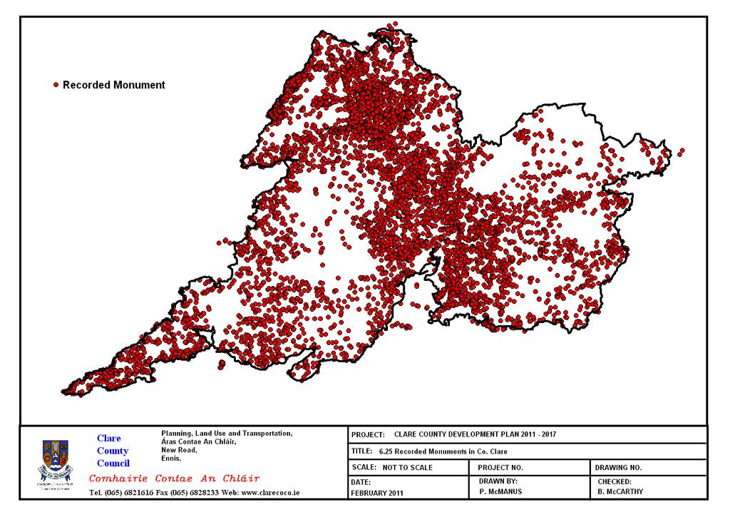
150
151
152 Environmental Parameter Baseline of County Clare 6.11: Landscape : Introduction The Heritage Act (1995) defines landscape as including areas, sites, vistas and features of significant scenic, archaeological, geological, historical, ecological or other scientific interest. The European Landscape Convention, 2002 provides the following definition of landscape; Landscape as an area, as perceived by people, whose character is the result of the action and interaction of natural and/or human factors. The landscape is made up whole great than its individual elements. As well as being an important part of people s lives - giving individuals and communities a sense of identity and belonging, and bestowing a sense of place on our surroundings - the landscape is the context in which all change takes place : Evolution of Landscape Designations and Protections in County Clare Clare County Council s policy approaches since 1967 shows the importance that has always been attributed to areas such as the Burren, the Atlantic Coast, Lough Derg, the Shannon Estuary, and upland areas such as the Slieve Aughty Mountains. There have been a number of studies to characterise the diverse landscapes of County Clare. These studies were combined to provide a very detailed set of landscape designations that appeared in the 2005 Clare County Development Plan. These Reports are: The CAAS Report (1997) Criteria for the Evaluation of Landscape Quality which identified the visually sensitive features of the landscapes of the County and informed the 1999 Clare County Development Plan, and The Heritage Council Landscape Character Study/ERM (2003) which provided a very detailed characterisation of the different parts of the County in line with the thinking of the DoEHLG s (2000) Landscape and Landscape Assessment Draft Guidelines for Planning Authorities. In the Clare County Development Plan Clare County Council in conjunction with CAAS Environmental Services have revisited the policy approach termed Clare s Living Landscapes. This approach builds on the Landscape Character Assessment of County Clare outlined below : Landscape Character Assessment One of the aims of the Landscape Character Assessment is to integrate components so that Landscape Character Areas for the County could be defined. These components are Landscape Character types, Landscape Character Areas and Seascape Character Areas a: Landscape Character Types Landscape character types are distinct types of landscape that are relatively homogenous in character. They are generic in nature in that they may occur in different localities throughout the County. Nonetheless, where they do occur, they commonly share similar combinations of geology, topography, land cover and historical land use, for example, limestone river valleys and blanket bog uplands. The Clare Landscape Character Assessment identifies 26 Landscape Character Types sub divided into 3 groups, namely; Upland Types, Lowland Types and Coastal Types. The LCA also identified Habitat Types and Historic Landscape Types. A Habitat Type is an area in which an organism or group of organisms lives, and is defined by the living (biotic) and non-living (abiotic) components of the environment. The latter includes physical, chemical and geographical factors, in addition to human impact or management. An archaeological or historic landscape is a discrete landscape based on the scale and integrity of the archaeological features [that] reflect significantly on the human history and land use of that area 137
153 Environmental Parameter Baseline of County Clare b: Landscape Character Areas Landscape Character Areas are units of the landscape that are geographically specific and have their own character and sense of place. Each Landscape Character Areas distinctive character is based upon patterns of geology, landform, landuse, cultural, historical and ecological features. The Landscape Character Assessment for County Clare identified 21 Landscape Character Areas illustration in Map c: Seascape Character Areas In the context of the Landscape Character Assessment process a Seascape is defined as comprising one or more views from land to sea, views from sea to land, views along coastline, and/or the effect on landscape of the conjunction of sea and land. The length of the County Clare coastline totals some 344km of which approximately 317km is on mainland Clare with the remaining 27km of coastline on the islands within the County. The LCA for County Clare identified 12 Seascape Character Areas which are outlined in Map : Living Landscapes of County Clare The Clare County Development Plan proposes a vision of Clare as a series of Living Landscapes where different parts of the County are regarded as having different potential for how communities can pursue their ambitions and aspirations. This approach is based on using places that make the best use of the different strengths and weaknesses of each area. Some areas have strong potential for tourism on account of their heritage and scenery, for example, while others have different potential on account of proximity to major roads or power lines. In this way different approaches emerge that are the most suitable for each area. It follows from this that what may be suitable in one area may not be suitable elsewhere. The three Living Landscape types outlined in Map 6.29 are: Settled landscapes where people live and work Working Landscapes intensively settled and developed areas within Settled landscapes or areas with a unique natural resource Heritage Landscapes where natural and cultural heritage are given priority but where development is not precluded rather things must happen more slowly and carefully a: Settled Landscapes Settled Landscapes comprise the network of farmland, villages and towns that make up the majority of the County. These landscapes are where the majority of the population live and work. They provide opportunities for enterprise, leisure and personal fulfilment. They contain the resources of land, soil, minerals and water that are used to sustain the economy. They accommodate the roads, power-lines, quarries and piped services that service settlements and industry. Settled Landscapes also contain areas of concentrated development called Working landscapes which are considered in more detail below. Uses envisaged within Settled Landscapes include agriculture, energy, forestry, extraction, transportation, industry & commerce, tourism, recreation and leisure, education, healthcare and social infrastructure. Criteria for definition of Settled Landscapes boundary All lands not classified as Heritage or Working Landscapes b: Working Landscapes Working Landscapes are parts Settled Landscapes that contain areas of concentrated development or a unique natural resource. This Plan identifies two in the County, namely; the Western Corridor - Ennis to Limerick Working landscape, and the Shannon Estuary Working Landscape. Western Corridor Working Landscape This part of the County contains the highest concentrations of population and jobs and the strongest transport links and connectivity. It includes the linked Gateway of 138
154 Environmental Parameter Baseline of County Clare Shannon and the County Town/Hub Town of Ennis. It is the economic driver of the County and an important component of the Mid West Region. Criteria for definition of Western Corridor Working Landscape All lands within 10km on either side of the N18/M18 except as excluded by Heritage Landscapes. The Shannon Estuary Working Landscape The Lower Shannon Estuary contains a nationally significant concentration of economic and natural resources. Extensive areas of sheltered deep water combined with one of the largest concentrations of high voltage transmission and generation capacity in the Country as well as adjacency to a large-scale International airport provide the conditions for the development of large-scale shipping, transhipment, logistic, manufacturing and associated economic and service activities. Criteria for definition of Shannon Estuary Working Landscape All shores and waters between Moyne Point & Ballynacragga point excluding Clonderalaw bay c: Heritage Landscapes These areas define places where the majority of County Clare s sensitive environmental resources scenic, ecological and historic, occur together. Heritage Landscapes are envisioned as the most valued parts of the County that are important to the people of Clare as well as the wider community both National and International. The principle role of Heritage Landscapes is to sustain natural and cultural Heritage. The word sustain is used to convey the idea of keeping something alive as opposed to conserve or preserve which might imply something dead or beyond use. These landscapes have to continue to evolve to accommodate both the renewal of existing houses, farms, roads, power-lines etc as well as the development of new facilities needed to support the community, particularly in areas where agriculture can no longer provide sufficient income. Uses within these landscapes are expected to include refurbishment of dwellings, new dwellings for members of the existing rural community and developments for agriculture, small-scale employment, tourism, forestry, education, culture and social services. Criteria for definition of Heritage Landscape boundary Heritage Landscape 1: Lough Derg and the Eastern Uplands This has been arrived at having regard to Heritage Council s LCA Study Unit 5 Slieve Aughty Uplands, Unit 6 Lough Graney and Unit 7 Lough Derg Basin Heritage Landscape 2: The Burren This has been arrived at having regard to Heritage Council s LCA Study Unit 1 Burren Uplands, Unit 2 Low Burren and Unit 4 Fergus Loughlands. Heritage Landscape 3: The Fergus/Shannon Estuary This has been arrived at having regard to the Heritage Council s Seascape Areas 9-12 Heritage Landscape 4: The Coast This has been arrived at having regard to the Heritage Council s Seascape Areas : Scenic Routes County Clare contains a number of valuable scenic routes which offer a very attractive cross-sectional view and overall impression of differing landscapes within Clare as one traverses the County. These scenic routes are interwoven with the Living, Working and Historic Landscapes as outlined above. Map 6.27 highlights Designated Scenic Routes throughout the County : Existing Environmental Problems In general the landscape is under the influence of several factors of change which may result in deterioration in the quality of its landscape. Forces of change to the landscape include changes in farming practices, the loss of traditional components of the landscape, e.g. stone walls, hedgerows, hazel scrub, inappropriate modern 139
155 Environmental Parameter Baseline of County Clare development and dereliction of older properties, and road development and improvements not sensitive to the surrounding landscape. A large portion of the Plan area is under urban generated development pressure with towns and villages experiencing rapid growth and development pressures over the last number of years. The expansion of settlements and influence of urban areas have had a negative effect on landscape change in some areas. In urban settings, townscape, streetscapes, and open space requirement issues arise. Also, in some areas the development of unsympathetic housing styles has had a negative impact on the rural quality of the landscape. The dereliction of farms and stone cottages and their replacement by modern bungalows not reflective of traditional vernacular styles have also impacted on the area. The unsustainable development of holiday homes in areas heavily frequented by tourists such as Kilkee and Lahinch disrupts the natural flow of the landscape. Pressures for increased tourism-related facilities such as Bunratty have also impacted on the landscape of the area. Visual detractors such as communication masts and windfarms in prominent high points threaten the visual quality of the landscape. Also, inappropriate expansion of coniferous forestry plantations can also detract from the natural landscape. Many areas within the Settled Landscapes, the Working Landscape, and the Heritage landscapes of Clare contain ground and surface waters that are sensitive to the risk of pollution and coincide with areas identified for nature conservation. The majority of the areas within the Shannon Estuary Working Landscape and the Heritage Landscapes contain sites, species, habitats and natural resources that are protected under the provisions of the Habitats Directive and/or the Birds Directive. Also, many areas within Heritage Landscapes contain significant concentrations of National Monuments. Some areas the land adjoining scenic routes can have relatively limited capacity (both environmentally and in terms of scenic amenity) to accommodate houses or other developments. Views and prospects to and from scenic routes are also under pressure : Evolution of Landscape in the absence of the CCDP In the absence of the CCDP there would not be a framework within which to regulate, aid and/or control development whether economic, social or environmental. A lack of development objectives would lead to large scale uncontrolled development haphazardly emerging throughout the County with no framework for directing housing and other development to appropriate locations. Certain areas, particularly along the coast, lakeshores and heritage areas would experience unprecedented pressures for individual dwellings, second homes and tourist related developments. This would have a direct adverse impact on the scenic views and visa in these area, and effect the overall quality and character of the landscape. With uncontrolled development the capacity of an area to visually absorb development at uninhibited scales will be challenged particularly as development becomes the dominant feature in a landscape. It is also likely that in the absence of a County Development Plan the cumulative effects of large development applications such as windfarm and quarrying applications would not be easily overseen or coordinated and assessed for their combined effects. Ultimately, the potential for fragmentation, loss, and/or deterioration of the landscape would occur. In addition, the landscape is made up of individual natural and cultural heritage elements, the environmental parameters and their interrelationships. Thus, under these circumstances the evolution of the Landscape in the absence of the Plan would be highly dependent on the rate and extent of uncontrolled developments. 140
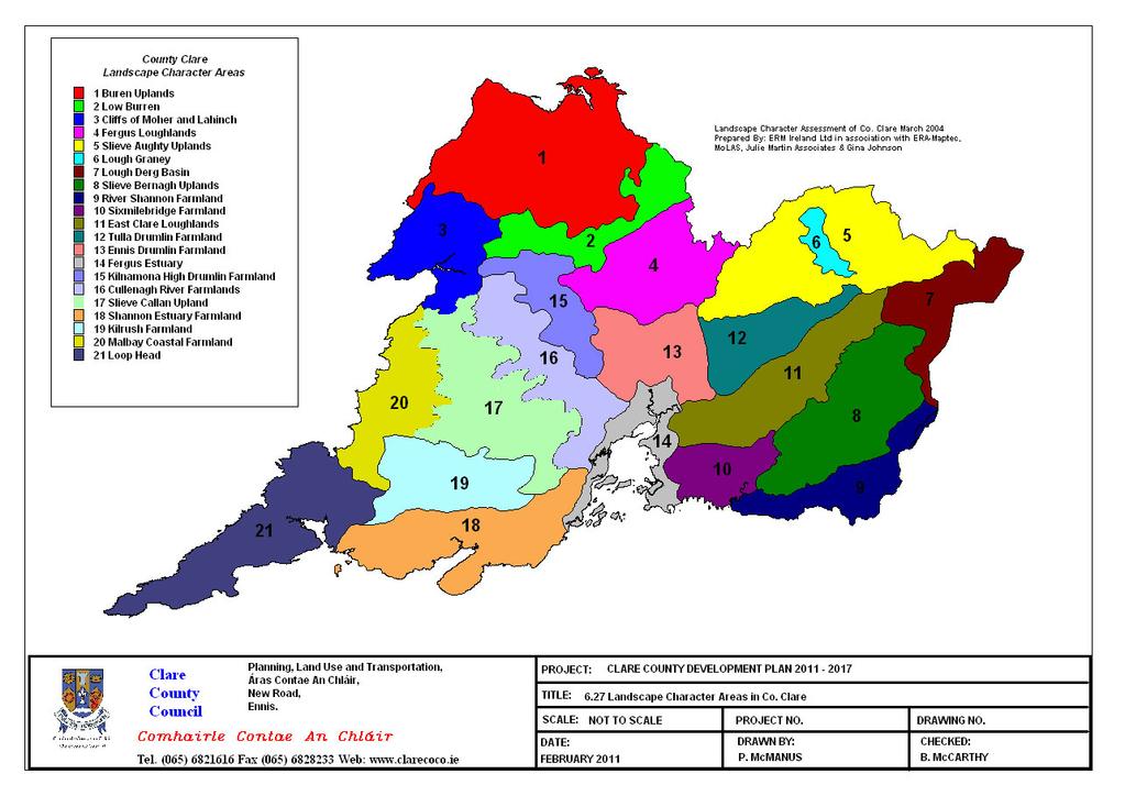
156
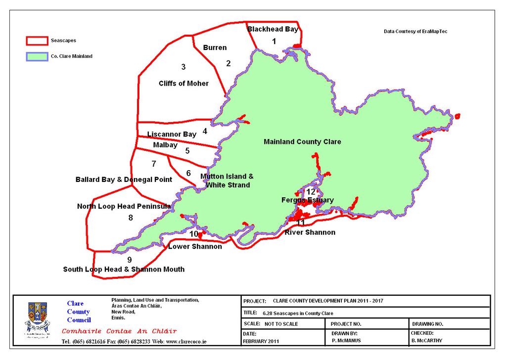
157
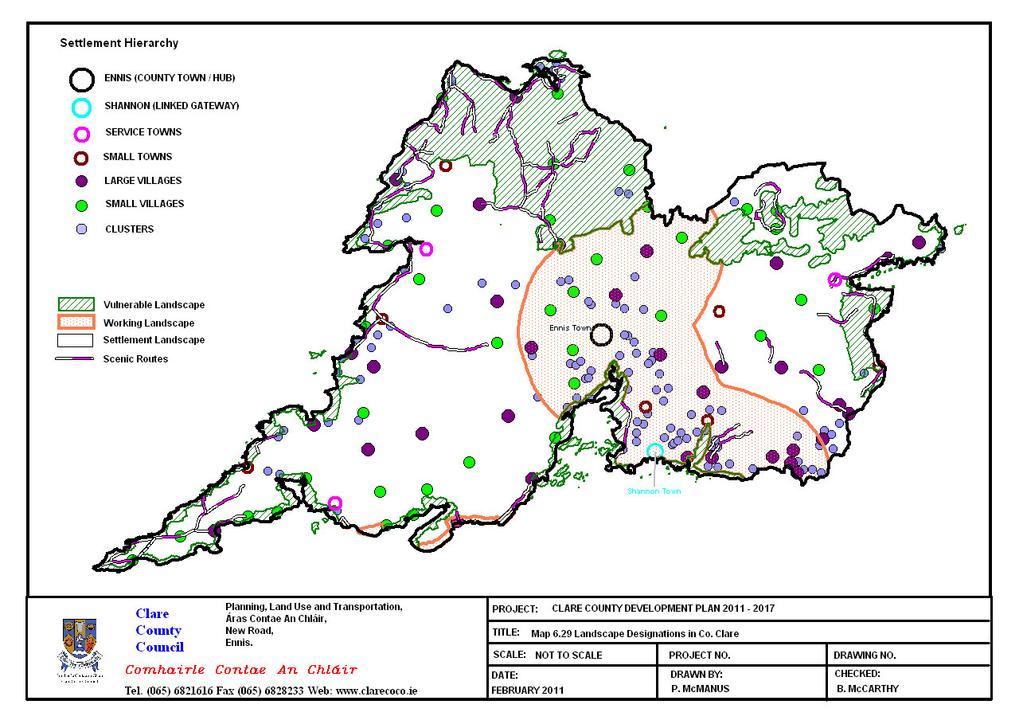
158
SEA OF EDENDERRY LOCAL AREA PLAN
 EDENDERRY LOCAL AREA PLAN 2017-2023 Strategic Environmental Assessment Environmental Report CLIENT Offaly County Council DATE September 2017 P a g e Contents Amendment Record This report has been issued
Cork County Development Plan Volume Three: SEA Statement and Natura Impact Report
 Cork County Development Plan 2014 Volume Three: SEA Statement and Natura Impact Report 3 Volume 3: SEA Statement and Natura Impact Report Cork County Development Plan 2014 Contents Section 1 Strategic
18 Cumulative Impacts and Interaction of Effects
 18 Cumulative Impacts and Interaction of Effects 18.1 Introduction This chapter addresses the cumulative impacts and main interactions between different aspects of the environment likely to be significantly
Draft Renewable Electricity Policy and Development Framework DRAFT STRATEGIC ENVIRONMENTAL ASSESSMENT SCOPING REPORT
 Draft Renewable Electricity Policy and Development Framework DRAFT STRATEGIC ENVIRONMENTAL ASSESSMENT SCOPING REPORT - 2016 Draft Renewable Electricity Policy and Development Framework DRAFT STRATEGIC
Performance Standard 6 V2
 Introduction 1. Performance Standard 6 recognizes that protecting and conserving biodiversity, maintaining ecosystem services, and sustainably managing living natural resources are fundamental to sustainable
Information on the focal point for the Convention. Information on the point of contact for the Convention
 Questionnaire for the REPORT OF MONTENEGRO ON THE IMPLEMENTATION OF THE CONVENTION ON ENVIRONMENTAL IMPACT ASSESSMENT IN A TRANSBOUNDARY CONTEXT in the period 2006 2009 Information on the focal point for
Clifton Marsh Landfill Variation of planning permission 05/09/0376 & 06/09/0395 for the continuation of landfilling until Non Technical Summary
 Clifton Marsh Landfill Variation of planning permission 05/09/0376 & 06/09/0395 for the continuation of landfilling until 2035 Non Technical Summary SLR Consulting Limited Project Ref: 403.00079.00474
Deliverable 2: Procedural guidelines as a recommendation to the national competent authorities
 Deliverable 2: Procedural guidelines as a recommendation to the national competent authorities Content Introduction... 2 Procedural Guidelines... 2 1. Scope of recommended procedural guidelines... 3 2.
Strategic Environmental Assessment Scoping Report. Dublin Port Masterplan Review Stakeholder Consultation
 Strategic Environmental Assessment Scoping Report Dublin Port Masterplan Review 2017 Stakeholder Consultation Table of Contents 1 Introduction... 1 1.1 Background... 1 1.2 Strategic Environmental Assessment...
Environmental Impact Assessment (EIA) Owen Struthers Development Management Branch Welsh Government
 Owen Struthers Development Management Branch Welsh Government") Environmental Impact Assessment (EIA) Owen Struthers Development Management Branch Welsh Government Environmental Impact Assessment Introduction New Directive: Directive 2014/52/EU of the European Parliament
Environmental Impact Assessment (EIA) Owen Struthers Development Management Branch Welsh Government Environmental Impact Assessment Introduction New Directive: Directive 2014/52/EU of the European Parliament
Water Framework Directive. Draft River Basin Management Plans. National Summary Programme of Measures
 Water Framework Directive Draft River Basin Management Plans National Summary Programme of Measures December 2008 Draft River Basin Management Plans National Summary of Programme of Measures Contents 1
STRATEGIC ENVIRONMENTAL ASSESSMENT SCREENING REPORT. for PROPOSED VARIATION NO 3 OF THE MEATH COUNTY DEVELOPMENT PLAN
 STRATEGIC ENVIRONMENTAL ASSESSMENT SCREENING REPORT for PROPOSED VARIATION NO 3 OF THE MEATH COUNTY DEVELOPMENT PLAN 2013-2019 for MEATH COUNTY COUNCIL December 2015 Brady Shipman Martin Canal House Canal
FRAMEWORK CONVENTION ON THE PROTECTION AND SUSTAINABLE DEVELOPMENT OF THE CARPATHIANS
 FRAMEWORK CONVENTION ON THE PROTECTION AND SUSTAINABLE DEVELOPMENT OF THE CARPATHIANS 2 The Parties, ACKNOWLEDGING that the Carpathians are a unique natural treasure of great beauty and ecological value,
ENVIRONMENTAL IMPACT ASSESSMENT (EIA) AND THE ENVIRONMENTAL IMPACT STATEMENT (EIS) 2.0 Developments requiring preparation of an EIS
 AND THE ENVIRONMENTAL IMPACT STATEMENT (EIS) 2.0 Developments requiring preparation of an EIS") ENVIRONMENTAL IMPACT ASSESSMENT (EIA) AND THE ENVIRONMENTAL IMPACT STATEMENT (EIS) 1.0 Background 2.0 Developments requiring preparation of an EIS 3.0 The contents of an EIS 4.0 Exemption from the requirement
ENVIRONMENTAL IMPACT ASSESSMENT (EIA) AND THE ENVIRONMENTAL IMPACT STATEMENT (EIS) 1.0 Background 2.0 Developments requiring preparation of an EIS 3.0 The contents of an EIS 4.0 Exemption from the requirement
1. RIVER BASIN MANAGEMENT
 1. RIVER BASIN MANAGEMENT 1.1 General New arrangements are being put in place to strengthen systems for the management of water quality and the protection of aquatic ecosystems. The new arrangements have
Spoil and Water. Irish Ports Association Conference Ciaran Callan Dublin Port Company. 26 th September 2008
 Spoil and Water Ciaran Callan Dublin Port Company Irish Ports Association Conference 2008 26 th September 2008 Disposal of Dredge Material: Regulation and Process of Application Requirement for disposal
ENVIRONMENTAL AND SOCIAL IMPACT ASSESSMENT GUIDELINES FOR HYDROPOWER PROJECTS IN MYANMAR
 ENVIRONMENTAL AND SOCIAL IMPACT ASSESSMENT GUIDELINES FOR HYDROPOWER PROJECTS IN MYANMAR Overview of Presentation 1. Objectives of the Consultancy 2. Hydropower in Myanmar 3. Draft Table of Contents 4.
Biodiversity Priorities for Ireland ( ) Andy Bleasdale
 Andy Bleasdale") Biodiversity Priorities for Ireland (2014-20) Andy Bleasdale Outline Introduction Natura 2000 in Ireland EU Biodiversity Strategy to 2020 Article 17 (and Article 12) Prioritised Action Framework for Ireland
Biodiversity Priorities for Ireland (2014-20) Andy Bleasdale Outline Introduction Natura 2000 in Ireland EU Biodiversity Strategy to 2020 Article 17 (and Article 12) Prioritised Action Framework for Ireland
Environmental Report Draft Dee Flood Risk Management Plan
 Environmental Report Draft Dee Flood Risk Management Plan Rev No 1.0 October 2014 Published by: Natural Resources Wales Cambria House 29 Newport Road Cardiff CF24 0TP 0300 065 3000 (Mon-Fri, 8am - 6pm)
Applying the proposed Strategic Siting Assessment Criteria: a study of the potential environmental and sustainability effects Appendices
 Towards a nuclear national policy statement Applying the proposed Strategic Siting Assessment Criteria: a study of the potential environmental and sustainability effects Appendices JULY 2008 Contents
SUPPORT IN THE PREPARATION OF THE STRATEGIC ENVIRONMENTAL ASSESSMENT (SEA) FOR THE REPUBLIC OF CROATIA S TRANSPORT DEVELOPMENT STRATEGY
 FOR THE REPUBLIC OF CROATIA S TRANSPORT DEVELOPMENT STRATEGY") S T U V W X Y Z [ Z \ V Z SUPPORT IN THE PREPARATION OF THE STRATEGIC ENVIRONMENTAL ASSESSMENT (SEA) FOR THE REPUBLIC OF CROATIA S TRANSPORT DEVELOPMENT STRATEGY NON-TEHNICAL October 2014 # $ % & $ ' (
S T U V W X Y Z [ Z \ V Z SUPPORT IN THE PREPARATION OF THE STRATEGIC ENVIRONMENTAL ASSESSMENT (SEA) FOR THE REPUBLIC OF CROATIA S TRANSPORT DEVELOPMENT STRATEGY NON-TEHNICAL October 2014 # $ % & $ ' (
Shell Quest Carbon Capture and Storage Project. Shell Canada Limited
 SCREENING SCOPING DOCUMENT For the proposed Shell Quest Carbon Capture and Storage Project Shell Canada Limited Prepared by: Canadian Environmental Assessment Agency Natural Resources Canada Fisheries
Technical Briefing: Water Framework Directive
 Technical Briefing: Water Framework Directive Summary: The Water Framework Directive (WFD) will revolutionise the way that the water environment is managed and protected. It replaces today s piecemeal
Report for Agenda Item: 2
 QLDC Council 28 September 2017 Department: Planning & Development Report for Agenda Item: 2 Stage 2 Proposed District Plan Notification Purpose The purpose of this paper is to present those parts of Stage
Guidelines for the Treatment of Air Quality During the Planning and Construction of National Road Schemes
 Guidelines for the Treatment of Air Quality During the Planning and Construction of National Road Schemes Consultation Draft NATIONAL ROADS AUTHORITY Guidelines for the Treatment of Air Quality During
Improving the condition of Solway Tweed s water environment Tweed area management plan
 Improving the condition of Solway Tweed s water environment Tweed area management plan 2010 2015 Supplementary to the river basin management plan for the Solway Tweed river basin district Page 1 of 20
Joint Statement. Pyli, Prespa, 2 February 2010
 Pyli, Prespa, 2 February 2010 Joint Statement The Ministers for the Environment of the three States sharing the Prespa Lakes Area and the European Commissioner for the Environment salute the conclusion
Alien species that threaten ecosystems, habitats or species I. STATUS AND TRENDS
 Page 249 VI/23. Alien species that threaten ecosystems, habitats or species The Conference of the Parties I. STATUS AND TRENDS 1. Notes the report on the status, impacts and trends of alien species that
STANDARD. Document information. Version: v4.8 Dec Date: Dec (c) 2012 European Water Partnership. All rights reserved.
 2012 European Water Partnership. All rights reserved.") STANDARD Document information Version: v4.8 Dec 2012 Language: English Date: Dec 2012 (c) 2012 European Water Partnership. All rights reserved. PAGE LEFT BLANK ON PURPOSE European Water Stewardship (EWS)
STANDARD Document information Version: v4.8 Dec 2012 Language: English Date: Dec 2012 (c) 2012 European Water Partnership. All rights reserved. PAGE LEFT BLANK ON PURPOSE European Water Stewardship (EWS)
Water Framework Directive Water for Life and Livelihoods
 England and Wales Approach to Implementation UKELA Conference 17th June 2005 Dr Martin Griffiths Environment Agency England and Wales Purpose Prevent deterioration, enhance status of aquatic ecosystems
Explanatory Memorandum to the Town and Country Planning (Environmental Impact Assessment) (Wales) Regulations 2017
 (Wales) Regulations 2017") Explanatory Memorandum to the Town and Country Planning (Environmental Impact Assessment) (Wales) Regulations 2017 This Explanatory Memorandum has been prepared by Planning Directorate and is laid before
Explanatory Memorandum to the Town and Country Planning (Environmental Impact Assessment) (Wales) Regulations 2017 This Explanatory Memorandum has been prepared by Planning Directorate and is laid before
THE COVENANT OF MAYORS FOR CLIMATE AND ENERGY
 THE COVENANT OF MAYORS FOR CLIMATE AND ENERGY We, the Mayors signing this Covenant, share a vision for a sustainable future - whatever the size of our municipality or its location on the world map. This
Integrated Coastal Zone Management
 Integrated Coastal Zone Management Steve Collins Marine Planning & Coastal Integration Team Date: 05 November 2014 Overview To cover ICZM History and context MSP Directive MPS How marine planning contributes
Key Components and Best Practices for Environmental Impact Assessments
 Key Components and Best Practices for Environmental Impact Assessments Introduction 1 The immense technological advances since the adoption of UN Convention on the Law of the Sea (UNCLOS) have exponentially
2016 COUNTRY UPDATE: CANADA
 2016 COUNTRY UPDATE: CANADA Trilateral Committee for Wildlife and Ecosystem Conservation and Management Lord Elgin Hotel, Ottawa, Canada Sue Milburn-Hopwood Canadian Wildlife Service May 19, 2016 New Government
THE ENVIRONMENTAL REPORT ON THE DRAFT SOUTH BALTIC CROSS-BORDER COOPERATION PROGRAMME
 THE WORK IS FINANCED BY THE EUROPEAN REGIONAL DEVELOPMENT FUND, AND BY THE STATE BUDGET THE ENVIRONMENTAL REPORT ON THE DRAFT SOUTH BALTIC CROSS-BORDER COOPERATION PROGRAMME 2014 2020 2014 1 2 ATMOTERM
Aquaculture in Natura 2000
 Aquaculture in Natura 2000 Vedran Nikolić DG ENVIRONMENT Nature unit Aquaculture in motion 2015 Integrating Aquaculture Bruxelles, 16 th November 2015 7 th Environment Action Program Living well, within
Hydropower Guidance Note: HGN 7 Competing Schemes
 Guidance Note Hydropower Guidance Note: HGN 7 Competing Schemes This guidance is not intended as a statement of law and should be read in combination with and in the context of the relevant enactments
Objectives Implications / comments
 Appendix 1: Environmental Protection Objectives Biodiversity UN Convention on Biological Diversity (1992) Bern Convention on the Conservation of European Wildlife and Natural Habitats (1979) Bonn Convention
Guidelines for Global Action on Peatlands (GAP)
") "Wetlands: water, life, and culture" 8th Meeting of the Conference of the Contracting Parties to the Convention on Wetlands (Ramsar, Iran, 1971) Valencia, Spain, 18-26 November 2002 Guidelines for Global
"Wetlands: water, life, and culture" 8th Meeting of the Conference of the Contracting Parties to the Convention on Wetlands (Ramsar, Iran, 1971) Valencia, Spain, 18-26 November 2002 Guidelines for Global
Conservation and Management of the Waddensea
 Conservation and Management of the Waddensea Fred van der Vegte Europarc, Sept. 12, 2009 1 Kust - en Zeebescherming 2 4 IUCN WORLD HERITAGE NOMINATION THE WADDEN SEA (GERMANY/THE NETHERLANDS) Criterion
ENVIRONMENTAL IMPACT STATEMENT METRO NORTH BELINSTOWN TO SWORDS STOP AREA MN101 VOLUME 2 BOOK 1 OF 7
 ENVIRONMENTAL IMPACT STATEMENT METRO NORTH BELINSTOWN TO SWORDS STOP AREA MN101 VOLUME 2 BOOK 1 OF 7 ENVIRONMENTAL IMPACT STATEMENT For ease of local identification this Environmental Impact Statement
DRAFT SUBMISSION REGARDING
 DRAFT SUBMISSION REGARDING Biodiversity Certification Draft Assessment Methodology DATE July 2010 Opening: The Local Government Association of NSW and Shires Association of NSW (the Associations) are the
Inventory, assessment and monitoring of wetlands: An integrated approach
 Inventory, assessment and monitoring of wetlands: An integrated approach Parikshit Gautam Director Freshwater & Wetlands Programme WWF - India Email: pgautam@wwfindia.net Taal 2007-12th World Lake Conference,
COAL AND COAL SEAM GAS REGULATION
 COAL AND COAL SEAM GAS REGULATION The Australian Government protects water resources from the impacts of coal and coal seam gas development through the water trigger provisions of the Environment Protection
Guiding Principles on Sustainable Hydropower Development in the Danube River Basin
 Guiding Principles on Sustainable Hydropower Development in the Danube River Basin Lead Countries : Austria, Romania, Slovenia in the frame of the International Commission for the Danube River Protection
Baltic Marine Environment Protection Commission
 Baltic Marine Environment Protection Commission HELCOM RECOMMENDATION 37/3 Adopted 11 March 2016, having regard to Article 20, Paragraph 1 b) of the Helsinki Convention SUSTAINABLE AQUACULTURE IN THE BALTIC
available in multiple formats Environmental Self-Assessment Handbook for Rail Infrastructure Projects
 available in multiple formats Environmental Self-Assessment Handbook for Rail Infrastructure Projects This document and other Canadian Transportation Agency publications are available on our Web site at
Natural Heritage assessment of small scale wind energy projects which do not require formal Environmental Impact Assessment (EIA).
.") Guidance Natural Heritage assessment of small scale wind energy projects which do not require formal Environmental Impact Assessment (EIA). March 2008 Table of Contents Page INTRODUCTION... 2 DEFINITIONS...
Guidance Natural Heritage assessment of small scale wind energy projects which do not require formal Environmental Impact Assessment (EIA). March 2008 Table of Contents Page INTRODUCTION... 2 DEFINITIONS...
Protection of Ramsar Wetlands under the EPBC Act
 Protection of Ramsar Wetlands under the EPBC Act 1. INTRODUCTION The Commonwealth Environmental Protection and Biodiversity Conservation Act 1999 (the EPBC Act ) commenced on 16 July 2000 and brought about
! Environmental Impact Assessment process!
 Environmental Impacts"! Environmental Impact Assessment process! Prof. Doutora Maria do Rosário Partidário Environmental Impacts @ MRPartidário 1 EIA Started with NEPA (National Environmental Policy Act,
CONVENTION ON MIGRATORY SPECIES
 CONVENTION ON MIGRATORY SPECIES CMS Distribution: General UNEP/CMS/Resolution 11.26 Original: English PROGRAMME OF WORK ON CLIMATE CHANGE AND MIGRATORY SPECIES Adopted by the Conference of the Parties
Outline for. Protected Areas Management Planning
 Outline for Protected Areas Management Planning Level One: Community-based protected area management organizations and Level Two: Conservation organizations / Non-governmental organizations Outline for
This standard will apply to English European Sites on land and water and to Marine Protected Areas (MPAs) within English territorial waters.
 within English territorial waters.") Natural England Standard Conservation Objectives for European Sites in England 1:0 About this standard Summary This strategic standard sets out Natural England s general approach to setting, managing and
Natural England Standard Conservation Objectives for European Sites in England 1:0 About this standard Summary This strategic standard sets out Natural England s general approach to setting, managing and
Planned & implemented wind energy projects in Greece in protected areas Challenges & successes
 Seminar on Good Practices for Reconciling Wind Energy Development and Biodiversity Conservation, Ministry of Environment & Energy Planned & implemented wind energy projects in Greece in protected areas
EU Water Framework Directive
 EU Water Framework Directive Overview and state of implementation TAIEX Seminar on the Water Framework and Urban Waste Water Directive Zagreb, 25-26 September 2008 Jorge Rodríguez Romero European Commission,
CHAPTER 3 POLICY, LEGAL AND ADMINISTRATIVE FRAMEWORK
 CHAPTER 3 POLICY, LEGAL AND ADMINISTRATIVE FRAMEWORK 3.1 Introduction Current national environmental policies are based on the need to take an integrated approach to environmental management and the need
L 328/28 Official Journal of the European Union DIRECTIVES
 L 328/28 Official Journal of the European Union 6.12.2008 DIRECTIVES DIRECTIVE 2008/99/EC OF THE EUROPEAN PARLIAMENT AND OF THE COUNCIL of 19 November 2008 on the protection of the environment through
ATTACHMENT E.2 EMISSIONS TO SURFACE WATERS SITE SERVICES LAYOUT SHEET 1 OF 2 (IE DR-0021)
") ATTACHMENT E.2 EMISSIONS TO SURFACE WATERS SITE SERVICES LAYOUT SHEET 1 OF 2 (IE0310818-30-DR-0021) SITE SERVICES LAYOUT SHEET 2 OF 2 (IE0310818-30-DR-0022) LOCATION OF EMISSION TO SURFACE WATER (IE0310818-22-DR-
ATTACHMENT E.2 EMISSIONS TO SURFACE WATERS SITE SERVICES LAYOUT SHEET 1 OF 2 (IE0310818-30-DR-0021) SITE SERVICES LAYOUT SHEET 2 OF 2 (IE0310818-30-DR-0022) LOCATION OF EMISSION TO SURFACE WATER (IE0310818-22-DR-
Draft Environmental Assessment Terminal B/C Redevelopment, Secure National Hall, and Related Improvements
 JUNE 2016 RONALD REAGAN WASHINGTON NATIONAL AIRPORT Draft Environmental Assessment Terminal B/C Redevelopment, Secure National Hall, and Related Improvements PREPARED BY: Ricondo & Associates, Inc. IN
Dang Thi Tuoi Biodiversity Conservation Agency (BCA) Ministry of Natural Resources and Environment of Vietnam (MONRE)
 Ministry of Natural Resources and Environment of Vietnam (MONRE)") Dang Thi Tuoi Biodiversity Conservation Agency (BCA) Ministry of Natural Resources and Environment of Vietnam (MONRE) Main Contents: 1. Roles of biodiversity in Vietnam 2. Threats to biodiversity in Vietnam
Dang Thi Tuoi Biodiversity Conservation Agency (BCA) Ministry of Natural Resources and Environment of Vietnam (MONRE) Main Contents: 1. Roles of biodiversity in Vietnam 2. Threats to biodiversity in Vietnam
A. EXECUTIVE SUMMARY. 1. Water status management. 1.1 Water status
 A. EXECUTIVE SUMMARY 1. Water status management 1.1 Water status Data and analyses of water status indicators suggest that the water resources in Croatia are subject to the impact of human activities.
ANNEX III ALMERIA DECLARATION
 page 1 ANNEX III ALMERIA DECLARATION We, the Environment Ministers and Heads of Delegations of the Contracting Parties to the Convention for the Protection of the Marine Environment and the Coastal Region
Current EC Biodiversity Policy
 Leonardo Massai Leonardo Massai Studied international politics at the University of Florence (Italy) and the Queen s University of Belfast (United Kingdom). Master of Science in Renewable Energy and Energy
European Treaty Series - No. 121 CONVENTION FOR THE PROTECTION OF THE ARCHITECTURAL HERITAGE OF EUROPE
 European Treaty Series - No. 121 CONVENTION FOR THE PROTECTION OF THE ARCHITECTURAL HERITAGE OF EUROPE Granada, 3.X.1985 2 ETS 121 Protection of the architectural heritage, 3.X.1985 The member States of
Struma Lot 3.2 EIA Development, Working Document
 Struma Lot 3.2 EIA Development, Working Document Revision 1, 03 February 2016 1 Introduction 1.1 Background Struma Motorway is one of the most challenging road projects in Bulgaria. The motorway is about
This document was endorsed by Cambridgeshire County Council (CCC) in its capacity as Lead Local Flood Authority on 14 July 2016.
 in its capacity as Lead Local Flood Authority on 14 July 2016.") Note to the reader Note to the reader This document was endorsed by Cambridgeshire County Council (CCC) in its capacity as Lead Local Flood Authority on 14 July 2016. Once adopted as a Supplementary Planning
Note to the reader Note to the reader This document was endorsed by Cambridgeshire County Council (CCC) in its capacity as Lead Local Flood Authority on 14 July 2016. Once adopted as a Supplementary Planning
ANNEXE 2: THE TERMS OF REFERENCE FOR ESIA AND RAP. 1. Objectives. The aim of the study is to achieve the following objectives:
 ANNEXE 2: THE TERMS OF REFERENCE FOR ESIA AND RAP 1. Objectives The aim of the study is to achieve the following objectives: Review of existing EIA and RAP reports on sections of the line which are not
Understanding the State Planning Policy July 2017 Changes to state interest statements, policies and assessment benchmarks
 Understanding the State Planning Policy July 2017 Changes to state statements, policies and assessment benchmarks This fact sheet outlines the key policy changes to the state statements, policies and assessment
Proceedings of the 6 TH Meeting of the Conference of the Contracting Parties (Brisbane, Australia, March 1996)
") CONVENTION ON WETLANDS (Ramsar, Iran, 1971) Proceedings of the 6 TH Meeting of the Conference of the Contracting Parties (Brisbane, Australia, 19-27 March 1996) RESOLUTION VI.1: WORKING DEFINITIONS OF
CONVENTION ON WETLANDS (Ramsar, Iran, 1971) Proceedings of the 6 TH Meeting of the Conference of the Contracting Parties (Brisbane, Australia, 19-27 March 1996) RESOLUTION VI.1: WORKING DEFINITIONS OF
2.1 Project Definition/Classification/Initial Study Project Definition
 2.1 Project Definition/Classification/Initial Study 2.1.1 Project Definition The correct and complete definition of all reasonably foreseeable elements of a proposed project is the single most important
10.0 AIR QUALITY AND CLIMATIC FACTORS
 .0 AIR QUALITY AND CLIMATIC FACTORS.1 ASSESSMENT METHODOLOGY.1.1 General Section 39 (2) (b) (ii) of the Transport (Railway Infrastructure) Act 2001, requires that proposed developments are examined in
The 3 rd National Biodiversity Strategy and Action Plan. Ministry of the Environment, JAPAN
 The 3 rd National Biodiversity Strategy and Action Plan Ministry of the Environment, JAPAN Brief History of Japan s National Biodiversity Strategies 1993: Entry into force of the Convention on Biological
Environmental Setting, Impacts, and Mitigation Measures
 First page header CHAPTER 4 Environmental Setting, Impacts, and Mitigation Measures 4.0 INTRODUCTION TO THE ENVIRONMENTAL ANALYSIS Sections 4.1 through 4.13 of Chapter 4 of this EIR contain a discussion
Climate Change and Renewable Energy Bill 2017*
 Queensland Climate Change and Renewable Energy Bill 2017* Current DRAFT as at 22 December 2017 *Material in this draft Bill has been excerpted from the Climate Change Act 2017 (Vic) and the Climate Change
ENVIRONMENT ACT TERMS OF REFERENCE NOVA SCOTIA DEPARTMENT OF TRANSPORTATION AND PUBLIC WORKS. Beaver Bank Bypass
 ENVIRONMENT ACT TERMS OF REFERENCE NOVA SCOTIA DEPARTMENT OF TRANSPORTATION AND PUBLIC WORKS Beaver Bank Bypass Highway 101 to the Beaver Bank Road Halifax County, NS NOVA SCOTIA DEPARTMENT OF THE ENVIRONMENT
EIA Regulations Cara Davidson
 EIA Regulations 2017 Cara Davidson EIA Directives EC Public Consultation EC proposals for revising EIA Directive EIA Directive amendment 2014/52/EU 2010 2012 2014 2009 2011 2013 2017 EU EIA Effectiveness
Species at Risk Act Policies and Guideline Series
 Species at Risk Act Policies and Guideline Series Addressing Species at Risk Act Considerations Under the Canadian Environmental Assessment Act for Species Under the Responsibility of the Minister responsible
PROJECT LIFE04 TCY/CRO/029. CAPACITY BUILDING FOR IMPLEMENTATION OF THE UNFCCC AND THE KYOTO PROTOCOL IN THE REPUBLIC OF CROATIA (CRO Climate Cap)
") PROJECT LIFE04 TCY/CRO/029 CAPACITY BUILDING FOR IMPLEMENTATION OF THE UNFCCC AND THE KYOTO PROTOCOL IN THE REPUBLIC OF CROATIA () THE LAYMAN'S REPORT BENEFICIARY Ministry of Environmental Protection,
PROJECT LIFE04 TCY/CRO/029 CAPACITY BUILDING FOR IMPLEMENTATION OF THE UNFCCC AND THE KYOTO PROTOCOL IN THE REPUBLIC OF CROATIA () THE LAYMAN'S REPORT BENEFICIARY Ministry of Environmental Protection,
COUNCIL OF EUROPE COMMITTEE OF MINISTERS. RECOMMENDATION No. R (84) 2 OF THE COMMITTEE OF MINISTERS TO MEMBER STATES
 2 OF THE COMMITTEE OF MINISTERS TO MEMBER STATES") COUNCIL OF EUROPE COMMITTEE OF MINISTERS RECOMMENDATION No. R (84) 2 OF THE COMMITTEE OF MINISTERS TO MEMBER STATES ON THE EUROPEAN REGIONAL/SPATIAL PLANNING CHARTER (Adopted by the Committee of Ministers
COUNCIL OF EUROPE COMMITTEE OF MINISTERS RECOMMENDATION No. R (84) 2 OF THE COMMITTEE OF MINISTERS TO MEMBER STATES ON THE EUROPEAN REGIONAL/SPATIAL PLANNING CHARTER (Adopted by the Committee of Ministers
Province - Department of Municipal and Provincial Affairs Nunatsiavut Government. Activities Responsibility Timing
 SUBJECT: Consultation on land use laws Activity Sheet: 10-1 OBLIGATION: PARTIES: Consult on land use policy or development regulation in Labrador Inuit Settlement Area (LISA) outside Labrador Inuit Lands
Introduction. They can help ensure that all key issues and elements have been considered; They help ensure that the review process is systematic; and
 Introduction There are many tools that a reviewer of environmental impact assessment documents can use to help determine whether such documents are complete and adequate. Among the powerful tools that
Climate Change and Renewable Energy Bill 2017*
 Queensland Climate Change and Renewable Energy Bill 2017* Current DRAFT as at 24 November 2017 *Material in this draft Bill has been excerpted from the Climate Change Act 2017 (Vic) and the Climate Change
Information Paper 10 Waste Water and Sewage Sludge
 DRAFT Consultation Document East Sussex, South Downs and Brighton & Hove Waste and Minerals Development Framework Information Paper 10 Waste Water and Sewage Sludge October 2011 DRAFT Information Paper
Technical Guidance Document for Strategic Environmental Assessment (SEA)
") Technical Guidance Document for Strategic Environmental Assessment (SEA) EAD-EQ-PCE-TG-03 Signature on Original Environment Quality Sector * Corporate Management Representative Secretary General Originated
Technical Guidance Document for Strategic Environmental Assessment (SEA) EAD-EQ-PCE-TG-03 Signature on Original Environment Quality Sector * Corporate Management Representative Secretary General Originated
European Union Strategy for Danube Region and the implementation of the Water Framework Directive
 COST 869 Mitigation options for Nutrient Reduction in Surface Water and Groundwaters Final Meeting, Keszthely, 12-14 October 2011 European Union Strategy for Danube Region and the implementation of the
DRAFT COUNTY DEVELOPMENT PLAN Non-Technical Summary of the SEA Environmental Report
 DRAFT COUNTY DEVELOPMENT PLAN 2016-2022 of the SEA Environmental Report Table of Contents Section 1 Introduction and Terms of Reference... 1 Section 2 The Draft Plan... 2 2.1 Background to and Content
Site Improvement Plan. Saltfleetby-Theddlethorpe Dunes & Gibraltar Point SAC
 Improvement Programme for England's Natura 2000 Sites (IPENS) Planning for the Future Site Improvement Plan Site Improvement Plans (SIPs) have been developed for each Natura 2000 site in England as part
Strategic Environmental Assessment Environmental Report
 Ex-ante Evaluation of the Cooperation Programme INTERREG VB North-West Europe 2014-2020 Strategic Environmental Assessment Environmental Report for GEIE GECOTTI INTERREG IVB Les Arcuriales, 6 th floor
Canada Border Services Agency Departmental Sustainable Development Strategy (DSDS)
") Canada Border Services Agency Departmental Sustainable Development Strategy (DSDS) 2017-2020 CONTENTS Introduction... 2 Section 1 Overview of the federal government s approach to sustainable development...
Canada Border Services Agency Departmental Sustainable Development Strategy (DSDS) 2017-2020 CONTENTS Introduction... 2 Section 1 Overview of the federal government s approach to sustainable development...
APPENDIX 2. Nova Scotia Department of Environment and Labour Environmental Assessment Terms and Conditions for Environmental Assessment Approval
 APPENDIX 2 Nova Scotia Department of Environment and Labour Terms and Conditions for Approval Approval Approval Date: March 14, 2007 Keltic Petrochemicals Inc. LNG and Petrochemical Plant Facilities Keltic
Comprehensive Study Scoping Document. for Lower Mattagami Hydroelectric Complex Redevelopment CEAR Reference Number:
 Comprehensive Study Scoping Document for Lower Mattagami Hydroelectric Complex Redevelopment CEAR Reference Number: 07-03-26302 Prepared pursuant to Subsection 21(1) of the Canadian Environmental Assessment
UNEP Principles 1. Integration of Tourism into Overall Policy for Sustainable Development
 UNEP Principles The principles cover: 1. Integration of Tourism into Overall Policy for Sustainable Development 2. Development of Sustainable Tourism 3. Management of Tourism 4. Conditions for Success
1. Purpose and scope. 2. When to consult SEPA
 Page no: 1 of 5 1. Purpose and scope 1.1 This guidance note provides advice to the Forestry Commission Scotland (FCS) and forest managers (including Forest Enterprise Scotland) on how and when to consult
Water & Agriculture. Seamus Barron Nitrates, Biodiversity & Engineering Division
 Water & Agriculture Seamus Barron Nitrates, Biodiversity & Engineering Division Presentation overview Water Framework Directive Nitrates regulations Support /initiatives for protecting water quality 2
GUIDANCE NOTES FOR INDUSTRY GUIDANCE NOTES ON THE OFFSHORE PETROLEUM PRODUCTION AND PIPELINES (ASSESSMENT OF ENVIRONMENTAL EFFECTS) REGULATIONS 1999
 REGULATIONS 1999") GUIDANCE NOTES FOR INDUSTRY GUIDANCE NOTES ON THE OFFSHORE PETROLEUM PRODUCTION AND PIPELINES (ASSESSMENT OF ENVIRONMENTAL EFFECTS) REGULATIONS 1999 Comments to be sent to: Environmental Management Team
GUIDANCE NOTES FOR INDUSTRY GUIDANCE NOTES ON THE OFFSHORE PETROLEUM PRODUCTION AND PIPELINES (ASSESSMENT OF ENVIRONMENTAL EFFECTS) REGULATIONS 1999 Comments to be sent to: Environmental Management Team
Water Framework Directive (WFD) River Basin District Management Systems. Interim Report of Working Group on Groundwater
 River Basin District Management Systems. Interim Report of Working Group on Groundwater") Water Framework Directive (WFD) River Basin District Management Systems Technical Requirements for Groundwater and Related Aspects Interim Report of Working Group on Groundwater September 2001 Contents
Water Framework Directive (WFD) River Basin District Management Systems Technical Requirements for Groundwater and Related Aspects Interim Report of Working Group on Groundwater September 2001 Contents
TERMS OF REFERENCE. Identification of the sources of pollution and assessing the impacts on the environment due to proposed project if any;
 TERMS OF REFERENCE 1.0 PROPOSED SCOPE OF WORK FOR EIA STUDY The components of the EIA study include: Determination of baseline data using primary data generation and secondary data available from various
The EU Water Framework Directive
 The EU Water Framework Directive Why is it important to the recreational boating industry? SEPTEMBER 2004 The EU Water Framework Directive: why is it important to the recreational boating industry? The
EBA/CP/2013/12 21 May Consultation Paper
 EBA/CP/2013/12 21 May 2013 Consultation Paper Draft Regulatory Technical Standards On Passport Notifications under Articles 35, 36 and 39 of the proposed Capital Requirements Directive Consultation Paper