Kern Water Bank. Kern Water Bank Authority
|
|
|
- Amos George
- 6 years ago
- Views:
Transcription

1 Kern Water Bank Kern Water Bank Authority
2 THE KERN WATER BANK Ensuring a Reliable Water Supply to the Southern San Joaquin Valley Providing for Exceptional Upland and Riparian Habitat Kern Water Bank Authority
3 Presentation Overview The Kern Water Bank Water Bank History Habitat Conservation Plan Water Resources Management Construction Project Kern Water Bank Authority
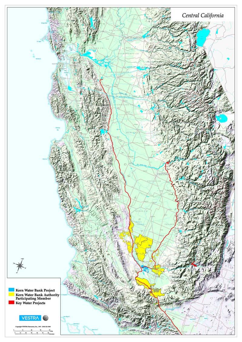
4 The Kern Water Bank & Why It Works Occupies 31 square miles SW of Bakersfield Located over permeable Kern River Fan sediments Central to several conveyance facilities Owned jointly by public water districts and private water companies Kern Water Bank Authority
5 Sources of Water California Aqueduct (State Water Project) Entitlement, interruptible Friant Kern Canal (Central Valley Project) Flood flows, surplus (e.g. 215) purchases Kern River Flood flows, miscellaneous purchases Kern Water Bank Authority
6

7 Kern Water Bank Authority
8 Kern Water Bank History Intermittently Flooded by Kern River Prior to Settlement 1880 s to 1930 s, Intermittently Flooded for Cattle Grazing 1930 s 1991 Intensive Farming & Groundwater Pumping 1986 Purchased by Department of Water Resources Kern Water Bank Authority

9 Kern Water Bank Authority
10 Kern Water Bank History 1994 Monterey Agreement 1995 Section 7 and 2081 Permits Issued for Interim Operation 1996 Acquisition by KWBA 1997 Habitat Conservation Plan Approved Kern Water Bank Authority
11 Kern Water Bank Funding Purchased from DWR through entitlement transfer Annual O&M funded through assessments Major construction project funded through private loan ($20 million) and Proposition 204 loan ($5 million) Kern Water Bank Authority
12 Habitat Conservation Plan Primary Objective - Water Conservation Storage of water during times of surplus for recovery during times of shortage Resulting Environmental Benefits Set aside large areas for threatened and endangered species Protect and enhance exceptional habitat Kern Water Bank Authority
13 HCP Elements Allow Economical Development of Water Management Facilities Recreate Historical Wetland Habitat Preserve Exceptional Upland Habitat Conserve Threatened or Endangered Species Provide Conservation Bank for Third Parties Permit Limited Farming Kern Water Bank Authority
14 Environmental Achievements Vegetation Benefits Emergent Riparian Habitat Developing Returning Farmed Areas to Upland Habitat Wildlife Benefits Biodiversity Increasing 77 New Species 40 New Waterfowl Species, 19 Reproducing Kangaroo Rat Populations Thriving Kern Water Bank Authority

15 Kern Water Bank Authority

16 Kern Water Bank Authority

17 Kern Water Bank Authority

18 Kern Water Bank Authority

19 Kern Water Bank Authority

20 Kern Water Bank Authority

21 Kern Water Bank Authority

22 Kern Water Bank Authority

23 Kern Water Bank Authority
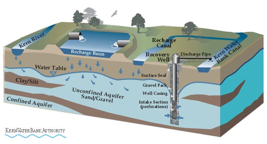
24 WATER RESOURCES MANAGEMENT Conjunctive Use to Provide for Reliable Water Supplies Kern Water Bank Authority
25 Groundwater Recharge 61 Shallow (2 ) Recharge Basins Basins occupy 11 square miles 63 miles of levees, 1.4 million cy of fill 820,000 AF Stored to Date 1,000,000 AF Total Capacity 450,000 AF Maximum Annual Recharge Capacity Kern Water Bank Authority
26

27 Kern Water Bank Authority

28 Kern Water Bank Authority

29 Kern Water Bank Authority

30 Kern Water Bank Authority
31 Groundwater Recovery Recovery Facilities 30 Existing wells 30 Proposed wells, 18 rehabilitated Pipelines (14 miles small diameter; 3 miles large diameter) Recovery Capacity Current 100,000 AF/year At project completion - 240,000 AF/year Kern Water Bank Authority

32 Kern Water Bank Authority
33 CONSTRUCTION PROJECT Facilities Designed to Meet Project Goals Kern Water Bank Authority
34 Kern Water Bank Canal Kern River to the California Aqueduct (6 Miles) Capacities Recharge 800 cfs from Kern River, 750 cfs from California Aqueduct Doubles existing capacity from aqueduct Recovery 630 cfs (460,000 acre-feet/year) to California Aqueduct Triples existing delivery capacity to aqueduct Kern Water Bank Authority

35 Kern Water Bank Authority
36 Kern Water Bank Canal Structures Headworks Enos Lane crossing Check structure Interstate 5 crossing Pump station Aqueduct turnout / in Kern Water Bank Authority
37 Canal Headworks Four 72-Inch Gates One 18-Inch Gate for City 275 CY Concrete, 24 Tons Steel Located on City Property Operated by Buena Vista WSD Cost $285,000 Kern Water Bank Authority

38 Kern Water Bank Authority

39 Kern Water Bank Authority
40 Canal Excavation Excavation Volume - 720,000 CY 4:1 Slopes Bentonite Application 11,000 Tons Avoids Trees Cost $2,225,000 Kern Water Bank Authority

41 Kern Water Bank Authority

42 Kern Water Bank Authority
43 Enos Lane Crossing and Check Structure 304 Feet of 96-Inch RCP Installed Using Jacking/Boring Method Sonic Metering 165 CY Concrete, 13 Tons Steel Telemetry to Headworks Cost $345,000 Kern Water Bank Authority

44 Kern Water Bank Authority
45 Pump Station Capacity CFS Four 120 cfs pumps One 65 cfs pump 20 Foot Lift Reverse Flow (330 CFS) for Recovery to Aqueduct Cost $1.2 Million Kern Water Bank Authority
46 Aqueduct Diversion Facilities Three 7-Foot Sluice Gates Metering Structure and Telemetry 330 Feet of 132-Inch RCP Canal Transition Structure 720 CY Concrete, 55 Tons Steel Operated by DWR Cost $1,650,000 Kern Water Bank Authority

47 Kern Water Bank Authority

48 Kern Water Bank Authority

49 Kern Water Bank Authority
50 Kern Water Bank Kern Water Bank Authority
Frequently Asked Questions Updated July 17, 2015
 Frequently Asked Questions Updated July 17, 2015 1. What is California WaterFix? California WaterFix is a proposal backed by the administrations of Governor Edmund G. Brown Jr. and President Barack Obama
Executive Summary. ES.1 Project Background
 ES.1 Project Background The natural flow of the Kern River has been apportioned among various water users pursuant to a series of court decisions and agreements including, but not limited to, the following:
Cadiz Inc. Corporate Presentation November 2017
 Cadiz Inc. Corporate Presentation November 2017 Cadiz Valley 1,300 square-mile watershed in Mojave Desert. Aquifer system holds approx. 20 million AF, like Lake Mead. Natural recharge 32,500 AF/year. Cadiz
Option 11. Divert Water from Miocene and Hendricks Canal to Supply the Ridge
 Integrated Water Resources Plan Option 11 Divert Water from Miocene and Hendricks Canal to Supply the Ridge This option would use water from the Miocene Canal and/or Hendricks Canal for municipal supplies
Questions and Answers about the Water Supply and Water Quality bond act for the November, 2018 ballot. Updated November 17, 2017
 Questions and Answers about the Water Supply and Water Quality bond act for the November, 2018 ballot. Updated November 17, 2017 What is the need for more State investment in water resources? What is the
State of the Valley Report
 State of the Valley Report An overview of the characteristics and trends of natural resources in the San Joaquin Valley s rural spaces, with an eye on resource sustainability for the future Aerial view
SUPERSEDED. BDCP Conservation Measure 1: Water Facilities and Operation. BDCP Bay Delta Conservation Plan
 BDCP Bay Delta Conservation Plan March 2013 BDCP Conservation Measure 1: Water Facilities and Operation A cornerstone of the Bay Delta Conservation Plan (BDCP) strategy is to construct and operate a dual-conveyance
134 FERC 61,195 UNITED STATES OF AMERICA FEDERAL ENERGY REGULATORY COMMISSION
 134 FERC 61,195 UNITED STATES OF AMERICA FEDERAL ENERGY REGULATORY COMMISSION Before Commissioners: Jon Wellinghoff, Chairman; Marc Spitzer, Philip D. Moeller, John R. Norris, and Cheryl A. LaFleur. Southern
Engineer s Report. Santa Clara Valley Water District California Aqueduct Reverse Flow Project Project No
 17 Santa Clara Valley Water District California Aqueduct Reverse Flow Project Project No. 60061007-6810 Engineer s Report February 2015 Water Utility Capital Division This page intentionally left blank.
Los Angeles 3 rd Regional
 Los Angeles 3 rd Regional Investors Conference Los Angeles, California March 31, 2016 Metropolitan Water District of Southern California 1 Metropolitan Water District of of Southern California 2 Metropolitan
Section II: Description of the Agricultural Water Supply and Service Area
 Section II: Description of the Agricultural Water Supply and Service Area A. Physical Characteristics 1. Size of service area The District is located in western Kern County and encompasses 97,396 acres
Are Juvenile Chinook Salmon Entrained at Unscreened Diversions in Direct Proportion to the Volume of Water Diverted?
 Are Juvenile Chinook Salmon Entrained at Unscreened Diversions in Direct Proportion to the Volume of Water Diverted? Charles H. Hanson Abstract Mark-recapture experiments were used to test the null hypothesis
Environmental Geography
 Environmental Geography Lecture 13 Water Pollution Lecture 13: Water Pollution I. Water Pollution A. Groundwater B. Surface Water C. Regulation II. Water Use in California 1 I. Water Pollution Types of
Colorado River Challenges Impacts to Southern Arizona
 Colorado River Challenges Impacts to Southern Arizona 2 3 4 5 Colorado River Basics 7 States, 2 Nations Annual Flow 15.0 MAF 40 Million People All of the Major Cities in Southwest 5.5m Irrigated Acres
SRCD s Review of Impacts the Proposed Bay Delta Conservation Plan (BDCP) and Companion EIR/EIS on the Suisun Marsh
 and Companion EIR/EIS on the Suisun Marsh") SRCD s Review of Impacts the Proposed Bay Delta Conservation Plan (BDCP) and Companion EIR/EIS on the Suisun Marsh By Steve Chappell, Executive Director Suisun RCD BDCP Document is Extremely Challenging
SRCD s Review of Impacts the Proposed Bay Delta Conservation Plan (BDCP) and Companion EIR/EIS on the Suisun Marsh By Steve Chappell, Executive Director Suisun RCD BDCP Document is Extremely Challenging
WATER RESOURCE PROGRAM
 SOUTH PLATTE WATER RESOURCE PROGRAM Establishing a lasting legacy of abundant clean water for waterfowl, wildlife and people Water is an essential resource for life and good health. It is vitally important
Pipelines to Nowhere? Structural Responses to Climate Change and Population
 Pipelines to Nowhere? Structural Responses to Climate Change and Population Presented by James Lochhead, Esq. Brownstein Hyatt Farber Schreck, LLP bhfs.com Evolving Strategies of Water Supply Development
Central Valley Project (CVP) Operations: In Brief
 Operations: In Brief") Central Valley Project (CVP) Operations: In Brief Charles V. Stern Specialist in Natural Resources Policy Pervaze A. Sheikh Specialist in Natural Resources Policy Betsy A. Cody Acting Senior Advisor to
Central Valley Project (CVP) Operations: In Brief Charles V. Stern Specialist in Natural Resources Policy Pervaze A. Sheikh Specialist in Natural Resources Policy Betsy A. Cody Acting Senior Advisor to
Hydropower Project License Summary PIT RIVER, CA PIT 1 HYDROELECTRIC PROJECT (P-2687) Pit River below Pit 1 Powerhouse
 Pit River below Pit 1 Powerhouse") Hydropower Project License Summary PIT RIVER, CA PIT 1 HYDROELECTRIC PROJECT (P-2687) Pit River below Pit 1 Powerhouse Photo: Hydropower Reform Coalition This summary was produced by the Hydropower Reform
Hydropower Project License Summary PIT RIVER, CA PIT 1 HYDROELECTRIC PROJECT (P-2687) Pit River below Pit 1 Powerhouse Photo: Hydropower Reform Coalition This summary was produced by the Hydropower Reform
Public Review Draft Part III Guidelines for the Application of Criteria for Financial Assistance for Local Projects.
 Bureau of Reclamation 800 Cottage Way, MP-170 Sacramento, Calif. 9585-1898 Public Review Draft for the Application of Criteria for March 9, 010 To: All Interested Parties and Organizations The U.S. Department
Keefer Pasture Drift Fence Project. Challis-Yankee Fork Ranger District Salmon-Challis National Forest
 Keefer Pasture Drift Fence Project Challis-Yankee Fork Ranger District Salmon-Challis National Forest PROPOSED ACTION The Challis-Yankee Fork Ranger District proposes construction of approximately.11 miles
U.S. Water Budget. Figure Source:Data from The Nation s Water Resources , Vol. 1, U.S. Water Resources Council.
 U.S. Water Budget Figure 10.18 10-9 Source:Data from The Nation s Water Resources 1975-2000, Vol. 1, U.S. Water Resources Council. Average U.S. Precipitation Figure 10.19 10-10 Source: U.S. Water Resources
California Water: Looking to the Future. Statistical Appendix
 Golden Gate University School of Law GGU Law Digital Commons California Agencies California Documents 1-1988 California Water: Looking to the Future. Statistical Appendix California Department of Water
NORTH TEXAS MUNICIPAL WATER DISTRICT EAST FORK RAW WATER SUPPLY PROJECT
 NORTH TEXAS MUNICIPAL WATER DISTRICT EAST FORK RAW WATER SUPPLY PROJECT Denise Hickey Agenda NTMWD Background Water Planning East Fork Raw Water Supply Project Overview Benefits Nature Center NTMWD BACKGROUND
Indirect Reuse with Multiple Benefits The El Monte Valley Mining, Reclamation, and Groundwater Recharge Project
 ABSTRACT & POWERPOINT PRESENTATION Indirect Reuse with Multiple Benefits The El Monte Valley Mining, Reclamation, and Groundwater Recharge Project Tim Smith Principal Engineer Helix Water District La Mesa,
EXHIBIT A JAMES GROUNDWATER STORAGE AND RECOVERY PROJECT NOTICE OF PREPARATION
 EXHIBIT A JAMES GROUNDWATER STORAGE AND RECOVERY PROJECT NOTICE OF PREPARATION Project Location The Project property, known locally as McAllister Ranch, is located in Kern County, California within Sections
TABLE OF CONTENTS 4.17 UTILITIES AND SERVICE SYSTEMS...
 TABLE OF CONTENTS 4.17 UTILITIES AND SERVICE SYSTEMS... 4.17-1 4.17.0 Introduction... 4.17-1 4.17.1 Methodology... 4.17-2 4.17.2 Existing Conditions... 4.17-2 4.17.3 Impacts... 4.17-4 4.17.4 Applicant-Proposed
Appendix D - Evaluation of Interim Solutions
 Appendix D - Evaluation of Interim Solutions D.1 Introduction The implementation of long-term improvements is projected to take 5 to 8 years. To reduce the number of years of flooding impacts, the partner
Water Education Foundation Briefing Water Year 2016: San Joaquin Valley Groundwater Conditions
 Groundwater in Fractured Rock Aquifers Well Location, Yield, and Sustainability Water Education Foundation Briefing Water Year 2016: San Joaquin Valley Groundwater Conditions John Kirk, PG, CEG, CHG Engineering
Solano Multi-Species Habitat Conservation Plan
 Solano Multi-Species Habitat Conservation Plan 580,000 Acres 37 Covered Species 4 Natural Communities 12,000 acres of Proposed Development Approximately 23,000 acres will be Preserved Plan Participants
CHAPTER 9 DISCUSSIONS, CONCLUSIONS, AND RECOMMENDATIONS
 CHAPTER 9 DISCUSSIONS, CONCLUSIONS, AND RECOMMENDATIONS This chapter summarizes the results of feasibility level investigations undertaken to identify solutions to the water and related land resource problems
Ponds. Pond A water impoundment made by excavating a pit, or constructing a dam or an embankment.
 POND SITE SELECTION AND CONSTRUCTION Uses, Planning, & Design David Krietemeyer Area Engineer USDA-NRCS June 20, 2008 Uses Considerations for Location of Commonly Used Terms Pond A water impoundment made
System Plan Components Inventory
 Northeast San Joaquin County Groundwater Bank System Plan Components Inventory Northeast San Joaquin County Groundwater Banking Authority April, 2002 The Northeast San Joaquin County Groundwater Banking
Environmental Information Worksheet
 Environmental Information Worksheet Water System Owner (Attach additional sheets if necessary) Needs and Alternatives Provide a brief narrative that describes: Current drinking water system needs. Project
TAUSSIG. & Associates, Inc. DAVID. Public Finance Facilities Planning Urban Economics CAPACITY FEE STUDY FOR SAN GORGONIO PASS WATER AGENCY
 DAVID TAUSSIG & Associates, Inc. CAPACITY FEE STUDY FOR SAN GORGONIO PASS WATER AGENCY JULY 21, 2015 Public Finance Facilities Planning Urban Economics Newport Beach Riverside San Francisco Chicago CAPACITY
FINDINGS: Olsson used a three-step analysis strategy to develop a benefit cost ratio that would indicate the relative feasibility of this project.
 EXECUTIVE SUMMARY FINDINGS: Based on the results of this feasibility study, the Platte Republican Diversion Project would be cost-effective. With minimal improvements to the channel, and the existing bridge
FOR SALE. 1,237.33± Acres, Wasco Kern County, California. CA BRE # Exclusively Presented By: Pearson Realty
 FOR SALE Wasco Almonds & Farmland Opportunity 1,237.33± Acres, Wasco Kern County, California Access to district & well water Quality soils & well water to work with 747.13± acres of almonds, 595.52± acres
Overview of Recent Developments in California Environmental Laws
 Overview of Recent Developments in California Environmental Laws Northwest Hydropower Conference March, 2009 James M. Lynch, Partner K&L Gates LLP (206) 370-6587 jim.lynch@klgates.com FERC Licensed Hydropower
XI. Thornton Planning Area
 XI. A. OVERVIEW The covers 120 square miles in the northwest corner of San Joaquin County. It consists primarily of low-lying Delta islands, sloughs, and large farms. The town of Thornton, a small agriculturally-based
Shortage on the Colorado River: Analysis of Impacts to Water Users in Central Arizona. Ken Seasholes
 Shortage on the Colorado River: Analysis of Impacts to Water Users in Central Arizona Ken Seasholes Manager, Resource Planning & Analysis AWRA Annual Conference, Denver November 19, 2015 Colorado River
NOTICE OF PREPARATION
 NOTICE OF PREPARATION Date: June 12, 2014 To: From: Subject: Governor s Office of Planning and Research/State Clearinghouse Unit, Responsible Agencies, Trustee Agencies, and Interested Parties Announcement
Chehalis Basin Strategy Programmatic SEPA Draft EIS
 Chehalis Basin Strategy Programmatic SEPA Draft EIS History of Flooding I-5 closed in 1990, 1996, 2007, 2009 Five largest flood events occurred since 1986 2 History of Habitat Degradation Harvest has been
PUBLIC NOTICE. Section 404 of the Clean Water Act (33 U.S.C. 1344) Section 10 of the Rivers and Harbors Act of 1899 (33 U.S.C.
 Section 10 of the Rivers and Harbors Act of 1899 (33 U.S.C.") US Army Corps Of Engineers Wilmington District PUBLIC NOTICE Issue Date: June 17, 2014 Comment Deadline: July 17, 2014 Corps Action ID#: SAW-2009-00655 NC DOT TIP: R-4903 The Wilmington District, Corps
US Army Corps Of Engineers Wilmington District PUBLIC NOTICE Issue Date: June 17, 2014 Comment Deadline: July 17, 2014 Corps Action ID#: SAW-2009-00655 NC DOT TIP: R-4903 The Wilmington District, Corps
Impairment in groundwater systems/hays water transfer
 Impairment in groundwater systems/hays water transfer GMD 3 annual meeting March 8, 2017 David Barfield, Chief Engineer Division of Water Resources Kansas Department of Agriculture Kansas Water Appropriations
STRAND RANCH INTEGRATED BANKING PROJECT
 STRAND RANCH INTEGRATED BANKING PROJECT Draft Environmental Impact Report Prepared for: Rosedale-Rio Bravo Water Storage District January 2008 STRAND RANCH INTEGRATED BANKING PROJECT Draft Environmental
Sections:
 DIVISION 15: NATURAL RESOURCES REGULATIONS CHAPTER 9-1500 NATURAL RESOURCES REGULATIONS: INTENT AND ORGANIZATION 9-1500.1 Title and Intent. 9-1500.2 Organization. 9-1500.1 TFlZE AND INTENT. Division 15
Chapter 8 National Economic Development and Locally Preferred Alternative
 Chapter 8 National Economic Development and Locally Preferred Alternative Determination of Feasibility This chapter considers the feasibility of the NED Plan and the Locally Preferred Alternative. As indicated
Hydrologic and Ecologic Impacts from the CERP Indian River Lagoon South Project
 Hydrologic and Ecologic Impacts from the CERP Indian River Lagoon South Project Dr. Gretchen Ehlinger Senior Biologist US Army Corps of Engineers Jacksonville District November 15, 2016 AWRA Conference
3 PROJECT DESCRIPTION
 3.1 PROJECT OVERVIEW 3 PROJECT DESCRIPTION The Rocklin 60 project (proposed project) includes the subdivision of 56.9 acres of land, construction of 179 single-family, detached dwelling units, and installation
 The Yolo Natural Heritage Program Interface with the Bay Delta Conservation Plan Background, Summary, and Remaining Issues May 23, 2013 Background The Yolo Natural Heritage Program (Yolo HCP/NCCP) and
STORMWATER HARVESTING FOR ALTERNATIVE WATER SUPPLY IN VOLUSIA COUNTY, FLORIDA
 STORMWATER HARVESTING FOR ALTERNATIVE WATER SUPPLY IN VOLUSIA COUNTY, FLORIDA Lena Rivera, P.E., D.WRE (CDM); Lee P. Wiseman, P.E., BCEE (CDM); Scott Mays, P.E. (Volusia County); and George Recktenwald
Blanche Park Reservoir Decision Notice and Finding of No Significant Impact
 Blanche Park Reservoir Decision Notice and Finding of No Significant Impact U.S. Forest Service Grand Mesa, Uncompahgre, and Gunnison National Forests Delta County, Colorado INTRODUCTION The Grand Mesa
Variable Frequency Drive (VFD) Controlled Irrigation Pumps Analysis of Potential Rebate
 Controlled Irrigation Pumps Analysis of Potential Rebate") Variable Frequency Drive (VFD) Controlled Irrigation Pumps Analysis of Potential Rebate Well pumps, booster pumps, and a combination of the two are used throughout the agricultural sector to provide water
Variable Frequency Drive (VFD) Controlled Irrigation Pumps Analysis of Potential Rebate Well pumps, booster pumps, and a combination of the two are used throughout the agricultural sector to provide water
PIMA COUNTY COMPREHENSIVE PLAN CO PIMA COUNTY REGIONAL COMPREHENSIVE PLAN POLICY MAJOR PLAN AMENDMENT
 PIMA COUNTY COMPREHENSIVE PLAN CO7-07-04 PIMA COUNTY REGIONAL COMPREHENSIVE PLAN POLICY MAJOR PLAN AMENDMENT Arizona law [A.R.S. 11-821(C)(3)] requires: Planning for water resources that addresses: a)
SOUTHERN NEVADA WATER BRIEFING Prepared for the Legislative Commission's Subcommittee to Study Water
 SOUTHERN NEVADA WATER BRIEFING Prepared for the Legislative Commission's Subcommittee to Study Water John J. Entsminger, General Manager Southern Nevada Water Authority EXHIBIT C - WATER Document consists
Constructed Wetland Use in Nonpoint Source Control
 Constructed Wetland Use in Nonpoint Source Control Description Constructed wetlands are excavated basins with irregular perimeters and undulating bottom contours into which wetland vegetation is purposely
Successful Floodplain Reconnection
 Successful Floodplain Reconnection Design, Implementation, Monitoring and Adaptive Management Upper Truckee River, Lake Tahoe, California Michael Rudd, PE, Charley Miller PE, Virginia Mahacek, Chad Krofta
Sacramento Valley Groundwater: An Approach to Better Understand and Manage the Lower Tuscan Groundwater Resources for Northern California
 Sacramento Valley Groundwater: An Approach to Better Understand and Manage the Lower Tuscan Groundwater Resources for Northern California The Sacramento Valley is recognized as one of the foremost groundwater
June 22, Francis E. Borcalli, P.E.
 CACHE CREEK SETTLING BASIN SYMPOSIUM Managing the Settling Basin Who s Doing What! June 22, 2009 Francis E. Borcalli, P.E. CACHE CREEK SETTLING BASIN SYMPOSIUM Managing the Settling Basin Who s Doing What!
Carbon-Capture Wetland Farming: Challenges and Opportunities for CA Delta
 Carbon-Capture Wetland Farming: Challenges and Opportunities for CA Delta Lisamarie Windham-Myers, Brian Bergamaschi, Robin Miller, Roger Fujii, Frank Anderson and the Organic Carbon Research Group in
Chapter 13: Wildlife and Vegetation
 Chapter 13: Wildlife and Vegetation Introduction and Setting Nevada County contains an extremely wide range of plants, animals and habitat types. With topographic elevations ranging from 300 feet in the
Myths and Facts about a Drought Year in the San Joaquin Valley
 Myths and Facts about a Drought Year in the San Joaquin Valley 2013 has been the driest year on record in California and Southern Oregon. In the San Joaquin Valley, Hanford, California, got only 1.99 inches
PREPARE60 OVERVIEW 1
 PREPARE60 OVERVIEW 1 UTAH S WATER BUDGET Category Total precipitation 61,500,000 Used by vegetation & natural systems 53,789,000 Basin Yield 7,711,000 Compact decreases 535,000 Ground water mining increases
ENVIRONMENTAL IMPACT ANALYSIS WATER RESOURCES: WATER SUPPLY 1. ENVIRONMENTAL CONDITIONS. a. Physical Setting. (1) Water Supply
 Water Supply") IV. E.2. ENVIRONMENTAL IMPACT ANALYSIS WATER RESOURCES: WATER SUPPLY 1. ENVIRONMENTAL CONDITIONS a. Physical Setting (1) Water Supply The Los Angeles Department of Water and Power (LADWP) owns, operates,
IV. E.2. ENVIRONMENTAL IMPACT ANALYSIS WATER RESOURCES: WATER SUPPLY 1. ENVIRONMENTAL CONDITIONS a. Physical Setting (1) Water Supply The Los Angeles Department of Water and Power (LADWP) owns, operates,
Holly Swartz and Jason Shirey
 Chapter 105 General Permits for Stream and Wetland Impacts DEP Ch. 105 CONTACTS FOR BERKS COUNTY: Holly Swartz and Jason Shirey What DEP Regulates Under Chapter 105 Waters of the Commonwealth, which includes
Agricultural/Rural Riparian Buffer Analysis
 Agricultural/Rural Riparian Buffer Analysis December 2014 Executive Summary The Agricultural/Rural Riparian Buffer Analysis was developed from a 2014 analysis of current requirements for the riparian areas
PROJECT INFORMATION Manchester Ranger District Apple Tree Release and Maintenance Project
 PROJECT INFORMATION Manchester Ranger District Apple Tree Release and Maintenance Project The USDA Forest Service is proposing to release and prune living apple trees in the Manchester Ranger District,
Committee on Water. Desalination as a Water Source
 Committee on Water Committee on Water Desalination as a Water Source Water Supply Reliability for San Diego County NARUC Summer Policy Summit July 17, 2017 Bob Yamada Director of Water Resources San Diego
4.6 - Hydrology and Water Quality
 City of Wasco - Wasco Center Walmart Hydrology and Water Quality 4.6 - Hydrology and Water Quality 4.6.1 - Introduction This section provides an evaluation of hydrology and water quality. The analysis
OPERATIONS IN THE MONO BASIN*
 LOS ANGELES DEPARTMENT OF WATER AND POWER OPERATIONS IN THE MONO BASIN* I APPRECIATE THIS OPPORTUNITY TO COMMENT ON THE DEPARTMENT'S WATER GATHERING OPERATIONS IN THE MONO BASIN AND THE RESULTING IMPACT
INDUSTRIAL SOLAR MANUFACTURING WWTP DESIGN AND EXPANSION
 Location Northwest Ohio Services Provided Engineering, Permitting, Installation of Equipment and Facilities Cost $3 million Size 300 GPM (432,000 GPD) Metal Hydroxide Precipitation WWTP 50 GPM (72,000
SCAMA / NOGALES WATER STORAGE STUDY APPRAISAL STUDY
 Photo by John Hoffman. The Santa Cruz River between Nogales and Tumacácori SCAMA / NOGALES WATER STORAGE STUDY APPRAISAL STUDY Presentation to GCASE Milestone Workshop 2 November 20, 2013 Presentation
Securing and Protecting Water Rights and Uses in Arizona
 Securing and Protecting Water Rights and Uses in Arizona L. William Staudenmaier One Arizona Center 400 East Van Buren Street, Suite 1900 Phoenix, Arizona 85004 2202 602.382.6000 602.382 6070 (fax) www.swlaw.com
Long-term Management Plan For The Mitigation Bank
 Note: The California multi-agency Project Delivery Team developed this general outline to assist in the development of the Long-term Management Plan for mitigation banks. Objectives and tasks are provided
Fort Collins WSDMP Update Additional Supplies and Facilities. Community Working Group Meeting #4 June 22, 2011
 Fort Collins WSDMP Update Additional Supplies and Facilities Community Working Group Meeting #4 June 22, 2011 1 Overview Existing water demands and supply system Future water demands Alternatives for meeting
Groundwater Recharge: A Role for Almonds? December 9, 2015
 Groundwater Recharge: A Role for Almonds? December 9, 2015 Speakers Gabriele Ludwig, Almond Board (Moderator) Daniel Mountjoy, Sustainable Conservation Joel Kimmelshue, Land IQ Helen Dahlke, University
OPERATION PLAN PERFORMANCE PLAN TEN MILE CREEK WATER PRESERVE AREA
 Revised 9 12 2011 to revise PE Certification page on Operation Plan and add PE Certification page to Performance Plan SOUTH FLORIDA WATER MANAGEMENT DISTRICT OPERATION PLAN PERFORMANCE PLAN TEN MILE CREEK
SAN GABRIEL RIVER/ COYOTE CREEK 2 LEVEE SYSTEM LOS ANGELES COUNTY, CALIFORNIA NLD SYSTEM ID #
 SAN GABRIEL RIVER/ COYOTE CREEK 2 LEVEE SYSTEM LOS ANGELES COUNTY, CALIFORNIA NLD SYSTEM ID # 3805010031 PERIODIC INSPECTION REPORT NO. 2 GENERALIZED EXECUTIVE SUMMARY FINAL SYSTEM RATING: MINIMALLY ACCEPTABLE
Opportunities for Improving Water Supply Reliability for Wildlife Habitat on the Tule Lake and Lower Klamath National Wildlife Refuges
 Opportunities for Improving Water Supply Reliability for Wildlife Habitat on the Tule Lake and Lower Klamath National Wildlife Refuges Parched wetlands on Lower Klamath National Wildlife Refuge, Sept.
EFFECT OF UPSTREAM DEVELOPMENT ON THE CLEAR CREEK AREA
 EFFECT OF UPSTREAM DEVELOPMENT ON THE CLEAR CREEK AREA Technical Memorandum Farming in the Floodplain Project Prepared for May 2017 PCC Farmland Trust Photo credit: Google Earth TABLE OF CONTENTS Page
Texas Groundwater Summit
 Guadalupe-Blanco River Authority Mid-Basin Water Supply Projects Texas Groundwater Summit James Lee Murphy, Esq. Executive Manager for Water Resources & Utility Operations Guadalupe-Blanco River Authority
Environmental Resource Permitting for Artificial Reefs
 South District Environmental Resource Permitting for Artificial Reefs February 17, 2015 Environmental Resource Permitting (ERP) The Environmental Resource Permitting Program regulates dredging, filling,
INFRASTRUCTURE. OPERATIONS. FINANCE AND COST ALLOCATION
 MODERNIZING THE SYSTEM: CALIFORNIA WATERFIX INFRASTRUCTURE. OPERATIONS. FINANCE AND COST ALLOCATION A California WaterFix Dialogue: QUESTIONS AND ANSWERS SEPTEMBER 2017 Benefit Analysis and Assumptions...
ARCHITECTURAL & ENGINEERING CONTRACTS TASK ORDER
 ARCHITECTURAL & ENGINEERING CONTRACTS TASK ORDER Public Draft Habitat Conservation Plan/Natural Community Conservation Plan TASK ORDER NO. ICF-11 and Amendment 1 Contractor:. Request for Services under
CALFED Ecosystem Restoration Program (ERP)
") CALFED Ecosystem Restoration Program (ERP) The goal of the Ecosystem Restoration Program is to improve and increase aquatic and terrestrial habitats and improve ecological functions in the Bay-Delta to
CALFED Ecosystem Restoration Program (ERP) The goal of the Ecosystem Restoration Program is to improve and increase aquatic and terrestrial habitats and improve ecological functions in the Bay-Delta to
Water and Environment. Monterey Peninsula, Carmel Bay and South Monterey Bay Integrated Regional Water Management Draft Plan
 Water and Environment Monterey Peninsula, Carmel Bay and South Monterey Bay Integrated Regional Water Management Draft Plan December 11, 2006 Presentation Outline Purpose of IRWM Planning Status of Plan
Information for File # PRH
 Information for File # 2016-02602-PRH Applicant Corps Contact Tom Morley Paul Hauser Address 152 Baker Drive, Redwood Falls, MN 56283 E-Mail Paul.R.Hauser@usace.army.mil Phone 651-290-5357 Primary County
Revised 8-4. Board of Directors Water Planning and Stewardship Committee. September 11, 2007 Board Meeting. Subject. Description
 Board of Directors Water Planning and Stewardship Committee September 11, 2007 Board Meeting Subject Adopt criteria for conveyance options in implementation of Long Term Delta Plan Description Revised
The Los Angeles Desalination Project
 DRAFT PROPOSAL The Los Angeles Desalination Project Author: Brian Nissen Company: Bella Machines www.bellamachines.com The Los Angeles Desalination Project CALIFORNIA WATER The California water crisis
Water Operations 101. Jerry Johns and John Leahigh Department of Water Resources BDCP Steering Committee 5/8/09
 Water Operations 101 Jerry Johns and John Leahigh Department of Water Resources BDCP Steering Committee 5/8/09 Water Operations Overview Where Does BDCP Fit Into California Planning Hydrologic Variability
2.1 Introduction. 2.2 Land Use and Jurisdictions Existing Conditions. Chapter 2 Land Use and Covered Activities
 Chapter 2 Land Use and Covered Activities 2.1 Introduction This chapter examines existing land use conditions and land use plans in the study area, and describes activities covered under the Plan. The
Q. PLEASE STATE YOUR NAME, BUSINESS ADDRESS AND CURRENT POSITION? A. Ron Cole- Refuge Manager, Klamath Basin National Wildlife Refuge Complex
 Q. PLEASE STATE YOUR NAME, BUSINESS ADDRESS AND CURRENT POSITION? A. Ron Cole- Refuge Manager, Klamath Basin National Wildlife Refuge Complex 4009 Hill Road, Tulelake, California 96134 Q. WHAT IS YOUR
THE SANTA YNEZ RIVER CONSERVATION DISTRICT IMPROVEMENT DISTRICT NO. 1 INTRODUCTION
 THE SANTA YNEZ RIVER CONSERVATION DISTRICT IMPROVEMENT DISTRICT NO. 1 INTRODUCTION The Santa Ynez River Water Conservation District, Improvement District No. 1 ("District" or "SYRWCD, ID#1") is a public
APPENDIX A. Project Scoping
 APPENDIX A Project Scoping Notice of Preparation To: From: Agencies and Interested Parties Paul Brunner, Executive Director, Three Rivers Levee Improvement Authority Date: June 13, 2006 Subject: Notice
Coastal Restoration and Protection Projects - SLFPA-East and Vicinity
 Coastal Restoration and Protection Projects - SLFPA-East and Vicinity committed to our coast committed to our coast 2012 Master Plan Project Details 2012 Master Plan Projects in SLFPA-East Projects in
For the property described as: Property Owner: Name. Phone Number. Mailing Address. City. Report Year:
 Timber Management Plan For the property described as: Property Owner: Name Phone Number Mailing Address City State Zip Report Year: (This template is provided to assist Cherokee County land owners who
Nestlé Waters North America Inc. Special Use Permit San Bernardino National Forest Project Proposal
 Nestlé Waters North America Inc. Special Use Permit San Bernardino National Forest Project Proposal 1. Introduction This document describes the project proposal for the short term (5 year) authorization
Measured Water Losses of Lateral A in Hidalgo County Irrigation District No. 2
 COLLEGE OF AGRICULTURE AND LIFE SCIENCES TR-74 011 Measured Water Losses of Lateral A in Hidalgo County Irrigation District No. By: Eric Leigh, Extension Associate and Guy Fipps, P.E., Extension Agricultural
City of Redlands Wastewater Treatment Plant. Redlands, CA LOCATION: Carollo Engineers; CH2M HILL MBR MANUFACTURER: COMMENTS:
 FACILITY: City of Redlands Wastewater Treatment Plant LOCATION: Redlands, CA GEO. AREA: Southern California STATUS 07/14: Operational CONSTRUCTION: ENGINEERING: Carollo Engineers; CH2M HILL MBR MANUFACTURER: