Potato Lake 2010 Project Results and APM Plan. Saturday May 28, 2011 Dave Blumer, Jake Macholl SEH Lake Scientists
|
|
|
- Mark Alvin Ramsey
- 6 years ago
- Views:
Transcription
1 Potato Lake 2010 Project Results and APM Plan Saturday May 28, 2011 Dave Blumer, Jake Macholl SEH Lake Scientists


2 Lake and Aquatic Plant Management Planning Goal: To maintain or improve the overall condition of Potato Lake for current and future lake users to enjoy Plant management Nutrient management Watershed management Shoreline management
3 Project Overview from May 2010 Phase One Lake Sampling Twice a month Three depths Multiple parameters Tributary Sampling 5 sites Outlet Monitoring Lake level Flow Volume Precipitation Monitoring Historic Paleocore Phase Two Plant Surveys Early season CLP & EWM Lake User Survey Crystal Lake/Price Pond Sampling Watershed Evaluation Education Invasive species Best Management Practices Function of the lake *Original proposal included four phases

4 Things to Determine Water budget Lake residence time Changes in lake level In-lake nutrient load Sources of nutrients Changes over time Plant management scenarios that maintain a balance between lake use and plant growth Nutrient management scenarios to reduce sources of phosphorous
5 Lake Inventory Physical Characteristics Water Quality Lake Inflow, Outflow, and Retention Time Soils Groundwater/conductivity Historic Conditions Nutrient Modeling Aquatic Plants/Invasive Species

6 Physical Characteristics Potato Lake 229 acres, Crystal Lake 22 acres, Price Pond 13 acres Watershed covers 3,229 acres (68% forest, 15.1% agriculture, 8.7% open water, 5.3% wetland, and 2.9% residential area) Headwaters of Potato Creek

7 Water Quality Water clarity Surface and bottom water chemistry Dissolved oxygen and temperature profiles Tributary sampling Outflow monitoring
8 General Comments No significant change in water clarity in the last 13 years were the worst years according to CLMN data (drought induced?) Big shift in water clarity every year in July Chlorophyll peaks in late summer at an average concentration for northern WI lakes Total phosphorus values were average for northern WI lakes at the surface and in the middle of the water column Total phosphorus was very high in the bottom waters in July and August indicating internal release of phosphorus from the sediment The nitrogen to phosphorus ratio in 2010 indicates that phosphorus is the limiting nutrient in Potato Lake
9 2010 Water Clarity (46 readings) 2010 Apr May Jun Jul Aug Sep Oct 0 2 SECCHI DEPTH, IN FEET Secchi Measure This decline in water clarity is seen every year since 1998
10 Dissolved Oxygen and Temperature Lake models and collected data suggest the lake is polymictic Potato Lake is mostly mixed with frequent short periods of stratification Stratification occurs, but may only last a few hours to a few days When stratified, dissolved oxygen concentrations are reduced or disappear completely in the bottom waters and phosphorus is released Remixing can bring that phosphorus back to the surface waters *Thus the lake acts like a phosphorus pump alternately stratifying and then mixing bringing phosphorus to the surface

11 Lake Inflow, Outflow, and Retention Time Ephemeral Streams The average phosphorus concentration measured in stream inputs was higher than the phosphorus being taken out of the lake by outflow Water retention time in Potato Lake is approximately 1.8 years Potato Lake is a phosphorus sink Under hi-flow conditions lake retention time may drop to 0.5 years Unknown if the excess phosphorus in the lake is removed primarily by plants, or deposited in the sediment
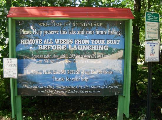
12 Concerns at the Outlet Dam Illegal cobble dams in the culvert may cause more harm than good Difficult to calculate true flow Does not raise the water level as much as one would expect Reduces rooted plant growth Inhibits fish passage May increase shoreland erosion Erodes the roadway *Erosion and reduction of rooted plants adds more unwanted nutrients to the lake to be used by algae
13 Soil Types in the Watershed and around the Lake Watershed soils classified as sandy loam, that is highly erodible particularly on steep slopes Allow rapid movement of water through it Good for preventing surface runoff Bad for filtering septic system loads Rapid movement of groundwater

14 Lake Conductivity Survey High conductivity indicates more minerals and salts in the water East shore and spring hole have the highest values Sources of minerals and salts Groundwater flow through local geology and soils Decomposing organic matter Presence of road salt or agricultural runoff Lawn fertilizers Septic system discharges We need to know more about the groundwater coming into Potato Lake
15 Historic Water Quality and Aquatic Plant Conditions Paleocore Results Had lots of plants Still has lots of plants, but not necessarily more plants Aquatic plant make-up has changed from smaller low growing species to larger and taller plant species More recently phosphorus levels have gone up, but significant changes in water quality haven t reflected that until the last few years Larger plants pull nutrients from the sediment Smaller plants attached to the larger plants pull nutrients directly from the water This change in plant make-up may have been able to cope with increased levels of phosphorus entering the system
16 How much Phosphorus is coming into the lake, and from where? Total Phosphorus Inputs to Potato Lake based on Modeling (450 lbs total phosphorus) Crystal Lake Price Pond Septic Systems Internal Loading Unspecified 3

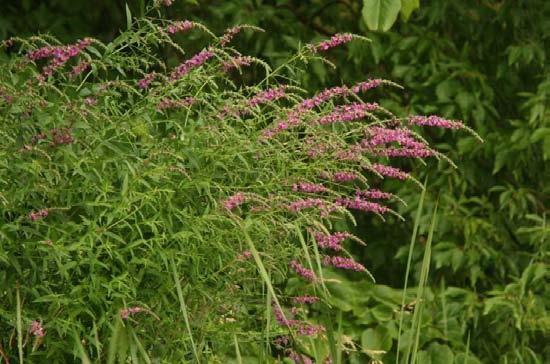
17 Aquatic Plants and Invasive Species Wild Rice Very abundant Highly prized and protected Basically untouchable A lucky to have resource Has helped to maintain water quality


18 Aquatic Invasive Species None were found!
19 Lake and Plant Facts the individual plants in Potato Lake are not unique or rare, but the overall community is 33 different species (state average is 21) FQI = 33.6 (state average is 22.2) No aquatic invasive species Abundant wild rice Lots of filamentous algae, but not where it is usually found Several species of plants that are dominant in Potato Lake, but nowhere else (flat-stem and Friess pondweed) Water with high mineral content leading to marl build-up on plants Up-welling or spring holes that are clearly visible and that impact conditions in the littoral zone


20 What makes Potato Lake Unique Black Globs of colonial blue-green algae (aphanocapsa) Pronghorn Clubtail (Gomphus graslinellus)
21 My Conclusions Potato Lake has successfully adapted to a build up of phosphorus over the course of many years The majority of water quality and excessive plant growth problems that people are concerned about are the result of the lake trying to cope with increased phosphorus inputs Potato Lake may not be able to handle these inputs further and maintain the high quality system you are used to Continual build-up of phosphorus will tip the lake over to an algae dominated rather than plant dominated system We need more information about individual sources of phosphorus, their impacts to the lake, and what we can do about them. Plant management to remove vegetation is a bad idea at the present time.
22 Increases in phosphorus levels only cause problems when a body of water can no longer handle those inputs
Portage Lake Hubbard County
 Prepared in cooperation with the Minnesota Department of Natural Resources Minnesota Lake ID: 9- Area: acres Watershed Area: 6,7 acres Ecoregion: Northern Lakes and Forests (NLF) Portage Lake Hubbard County
BIG ROCHE A CRI LAKE CHARACTERISTICS
 BIG ROCHE A CRI LAKE CHARACTERISTICS Lake Description Big Roche Cri Lake is located in north central Adams County and has a surface area of 205 acres, a shoreline length of 6.1 mile, a volume of 6,993
An Introduction to The Ecology of Lakes, Ponds and Reservoirs. Developing a Management Plan
 An Introduction to The Ecology of Lakes, Ponds and Reservoirs Developing a Management Plan Stephen J. Souza, Ph.D. Princeton Hydro, LLC 1108 Old York Road Ringoes, NJ 08551 ssouza@princetonhydro.com Objective
Minnesota Department of Natural Resources. Aquatic Plant Management Program
 Minnesota epartment of Natural Resources Aquatic Plant Management Program The Goal of the MN NR s Aquatic Plant Management Program-APM Protect & enhance Minnesota s aquatic resources, while allowing lakeshore
Oswego Lake: Beneath the Surface. an investigation into your lake s health
 Oswego Lake: Beneath the Surface an investigation into your lake s health LAKE SIZE... 83 acres WATERSHED SIZE... 71,660 acres MAX DEPTH... 36 feet INLETS... Flow from Lake Tippecanoe Oswego Lake OUTLETS...
Winter Drawdown Proposal for Control of EWM in Long Trade Lake. Informational Meeting Saturday, August 25, 2012
 Winter Drawdown Proposal for Control of EWM in Long Trade Lake Informational Meeting Saturday, August 25, 2012 Recent Management Summary Trade Lakes System Summer 2011 Aquatic Plant Management Plan for
Crystal Lake and Keller Lake Water Quality Evaluation and Ferric Chloride Treatment Project
 Crystal Lake and Keller Lake Water Quality Evaluation and Ferric Chloride Treatment Project Assessment for 8 Prepared for Black Dog Watershed Management Organization January 9 Crystal Lake and Keller Lake
BLACK OTTER LAKE DISTRICT
 BLACK OTTER LAKE DISTRICT Storm water Action Plan Action Plan submitted for UW-Madison Course 272630 JDD001 #41967 Great Lakes Water Stewardship Institute 2012 Hortonville Area School District Hortonville
Hydrology of the Bear Lake Basin, Utah
 Natural Resources and Environmental Issues Volume 14 Bear Lake Basin Article 13 1-1-2007 Hydrology of the Bear Lake Basin, Utah Patsy Palacios SJ & Jessie E Quinney Natural Resources Research Library,
A Successful Lake Management Program for Lake Mitchell PROFESSIONAL ENGINEERS AND SCIENTISTS SPECIALIZING IN WATER RESOURCES
 A Successful Lake Management Program for Lake Mitchell PROFESSIONAL ENGINEERS AND SCIENTISTS SPECIALIZING IN WATER RESOURCES Tonight s Agenda 1. General Review of FYRA Engineering and Qualifications 2.
VILLAGE OF BELLAIRE WATER QUALITY ACTION PLAN
 VILLAGE OF BELLAIRE WATER QUALITY ACTION PLAN Elk-River-Chain-of-Lakes Gaps Analysis Project The Watershed Center Grand Traverse Bay Tip of the Mitt Watershed Council Michigan Department of Natural Resources
WATERSHED. Maitland Valley. Report Card 201
 Maitland Valley WATERSHED Report Card 201 The Maitland Valley Conservation Authority has prepared this report card as a summary on the state of our forests, wetlands, surface water, and ground water resources.
Hydrology, Water Quality, and Phosphorus Loading of Little St. Germain Lake, Vilas County, Wisconsin
 Hydrology, Water Quality, and Phosphorus Loading of Little St. Germain Lake, Vilas County, Wisconsin Introduction Little St. Germain Lake, which is in Vilas County, Wisconsin, just northeast of St. Germain
TORCH LAKE TOWNSHIP WATER QUALITY ACTION PLAN
 TORCH LAKE TOWNSHIP WATER QUALITY ACTION PLAN Elk-River-Chain-of-Lakes Gaps Analysis Project The Watershed Center Grand Traverse Bay Tip of the Mitt Watershed Council Michigan Department of Natural Resources
2008 SUMMARY REPORT of North Loon Lake NICC Pond. Lake County, Illinois
 2008 SUMMARY REPORT of North Loon Lake NICC Pond Lake County, Illinois Prepared by the LAKE COUNTY HEALTH DEPARTMENT ENVIRONMENTAL HEALTH SERVICES LAKES MANAGEMENT UNIT 3010 Grand Avenue Waukegan, Illinois
2016 Data Report for Barlow Lake, Barry County
 Michigan Lakes Ours to Protect 216 Data Report for Barlow Lake, Barry County Site ID: 8176 42.67559 N, 85.5242 W The CLMP is brought to you by: 1 About this report: This report is a summary of the data
EUTROPHICATION. Student Lab Workbook
 EUTROPHICATION Student Lab Workbook THE SCIENTIFIC METHOD 1. Research Background literature research about a topic of interest 2. Identification of a problem Determine a problem (with regards to the topic)
Ecosystems: Nutrient Cycles
 Ecosystems: Nutrient Cycles Greeks, Native Peoples, Buddhism, Hinduism use(d) Earth, Air, Fire, and Water as the main elements of their faith/culture Cycling in Ecosystems the Hydrologic Cycle What are
Chapter 3. Lake Assessments
 Chapter 3. Lake Assessments Introduction The Pelican Group of Lakes encompasses 4 lakes: Pelican, Little Pelican, Bass, and Fish. Although these lakes have somewhat different characteristics, they are
Status and Trends of Water Quality in Wisconsin s Lakes, Streams, and Rivers
 Status and Trends of Water Quality in Wisconsin s Lakes, Streams, and Rivers Tim Asplund, Matt Diebel, Katie Hein, and Mike Shupryt Water Resources Program, WDNR AWRA Wisconsin Section Annual Meeting March
Orange County Fertilizer Application Education Course for Citizens
 Orange County Fertilizer Application Education Course for Citizens Thanks for taking the time to learn how to keep Central Florida beautiful while protecting our water quality! Why is Orange County Requiring
Welcome. Thank you for joining us!
 Welcome. Thank you for joining us! Watershed Restoration and Protection Strategy (WRAPS) Study Implementation Workshop June 24, 2014 Lower Mississippi River Watershed Management Organization Tonight s
Results of Water Quality Measurements in Messer Pond Bob Crane, Messer Pond Protective Association (MPPA) Board
 Board") Results of Water Quality Measurements in Messer Pond Bob Crane, Messer Pond Protective Association (MPPA) Board The collection of water samples for the assessment of water quality in Messer Pond, New London,
Results of Water Quality Measurements in Messer Pond Bob Crane, Messer Pond Protective Association (MPPA) Board The collection of water samples for the assessment of water quality in Messer Pond, New London,
Lake Emily CROW WING COUNTY
 Lake Emily 18-0203-00 CROW WING COUNTY Lake Water Quality Summary Lake Emily is located on the eastern edge of the City of Emily, MN in Crow Wing County. It is a shallow lake that covers 720 acres and
Gull Lake CASS & CROW WING COUNTIES
 Gull Lake 11-0305-00 CASS & CROW WING COUNTIES Summary Gull Lake is located just northwest of Brainerd, Minnesota, on the border of Cass and Crow Wing Counties. It covers 9,947 acres, which places it in
LAKE BELLAIRE SHORELINE SURVEY SUMMARY REPORT
 1 LAKE BELLAIRE SHORELINE SURVEY SUMMARY REPORT Three Lakes Association PO Box 689 Bellaire, MI 49615 by William Bohannon, Braden Ackerman, Wilhelmina Witt and TLA Volunteers August 30, 2008 3 Developed
Healthy lakes add value to our communities. They provide a place to relax and recreate,
 Pike Lake Eastern Marathon County Lake Study Final Study Results 2013 University of Wisconsin-Stevens Point and Marathon County Staff and Citizens Healthy lakes add value to our communities. They provide
REVIEW OF PHASE I WATER QUALITY DIAGNOSTIC STUDY OF LAKE AUBURN AND ITS WATERSHED LAKE AUBURN WATERSHED PROTECTION COMMISSION PUBLIC MEETING
 REVIEW OF PHASE I WATER QUALITY DIAGNOSTIC STUDY OF LAKE AUBURN AND ITS WATERSHED LAKE AUBURN WATERSHED PROTECTION COMMISSION PUBLIC MEETING In collaboration with: Comprehensive Environmental, Inc. and
Understanding the Basics of Limnology
 Understanding the Basics of Limnology Outline Watershed Processes Lake Formation Physical Features of Lakes Lake Processes Lake Chemistry Lake Biology Lake Management WATERSHED PROCESSES A Lake is a Reflection
Design Features of Constructed Wetlands for Nonpoint Source Treatment. September 1995
 Design Features of Constructed Wetlands for Nonpoint Source Treatment September 1995 Brochure written by William W. Jones, School of Public and Environmental Affairs, Indiana University, Bloomington, Indiana.
Lakes and Ponds. Questions to consider. Ponds breathe. Sinkhole pond. Oxbow lake. Farm pond. Reservoir
 8 Lakes and Ponds dane johnson / visuals unlimited Oxbow lake Farm pond Sinkhole pond Reservoir albert copley / visuals unlimited Questions to consider 1 2 3 4 5 6 7 How do oxygen levels in ponds change
Boy Lake CASS COUNTY
 Boy Lake 11-143- CASS COUNTY Summary Boy Lake is located near Remer, MN in Cass County. It covers 3,452 acres, which places it in the upper 1% of lakes in Minnesota in terms of size. Boy Lake has two main
Powers Lake Management Plan Washington County, MN
 Guy Rose: (River Epte, Giverny), 1904-12 Powers Lake Management Plan Washington County, MN March 2000 Prepared for: South Washington Watershed District Prepared by: Bonestroo, Rosene, Anderlik and Associates
Carp Creek 2013 Summary Report
 Monitoring Activity in the Carp River Watershed In 2012, Mississippi Valley Conservation Authority (MVCA) worked with Friends of the Carp River (FCR) on a preliminary assessment of the Carp River. This
Water and Watersheds. Data Maps Action
 Water and Watersheds Data Maps Action What is the Wildlife Action Plan? Restore rare wildlife and habitats. Keep common species common. 2015 Revision: Partners in Conservation Science 2015 Revision Data
Laurel Lake water quality, nutrients, and algae, summer
 Laurel Lake water quality, nutrients, and algae, summer 2011 1 H.A. Waterfield, W.N. Harman and M.F. Albright SAMPLING ACTIVITIES Site visits to Laurel Lake were made on 16 June and 25 July 2011; water
NOTEBOOK. Table of Contents: 9. Properties of Water 9/20/ Water & Carbon Cycles 9/20/16
 NOTEBOOK Table of Contents: 9. Properties of Water 9/20/16 10. Water & Carbon Cycles 9/20/16 NOTEBOOK Assignment Page(s): Agenda: Tuesday, September 20, 2016 Properties of Water Water & Carbon Cycles 1.
POLICY FOR NATURAL RESOURCE MANAGEMENT AREAS
 POLICY FOR NATURAL RESOURCE MANAGEMENT AREAS I. POLICY STATEMENT Auburn University's (the University's) "Policy for Natural Resource Management Areas" implements the Campus Master Plan Land Use Element
MURPHY DRAIN CATCHMENT
 The RVCA produces individual reports for 16 catchments in the Lower Rideau subwatershed. Using data collected and analysed by the RVCA through its watershed monitoring and land cover classification programs,
Gas Guzzlers. Biological Pump
 Gas Guzzlers Biological Pump Aquatic Biodiversity Chapter 8 Coral Reefs Open Ocean Deep Sea Marine equivalent of tropical rain forests Habitats for one-fourth of all marine species Coral polyps, which
Mud Lake Lakeshed Assessment
 Mud Lake Lakeshed Assessment The lakeshed vitals table identifies where to focus organizational and management efforts for each lake. Criteria were developed using limnological concepts to determine the
Climate Change, Marsh Erosion and the Chesapeake Bay TMDL
 Climate Change, Marsh Erosion and the Chesapeake Bay TMDL Rising sea level in Chesapeake Bay is inexorable. One environmental effect associated with sea level rise is marsh erosion. Marsh erosion can impact
The Myakka River. Presented to the Myakka River Management Coordinating Council January 9, 2009
 The Myakka River Presented to the Myakka River Management Coordinating Council January 9, 2009 Kathryn L. Meaux Environmental Specialist III Sarasota County Integrated Water Resources Historical Monitoring
The Sustainability of Floods Pond
 The Sustainability of Floods Pond Bangor Water District s Public Water Supply Presented By: Rick Pershken Bangor Water District Overview Brief BWD History Watershed Characteristics Lake Characteristics
Nutrient Management in. A presentation to the West Metro Water Alliance
 Nutrient Management in Developing and Agricultural Areas A presentation to the West Metro Water Alliance Chris Meehan, P.E. May 25, 2011 Agenda Physical Improvements Planning Improvements How to get it
ALMY POND TMDL MANAGEMENT PLAN
 ALMY POND TMDL MANAGEMENT PLAN PUBLIC WORKSHOP Presented by: City of Newport Department of Utilities And Pare Corporation May 7, 2014 Presentation Overview Introduction to Almy Pond Project Introduction
The Hypoxic Zone in the Gulf of Mexico
 The Hypoxic Zone in the Gulf of Mexico References Council Committee on Environmental and Natural Resources. 2003. An Assessment of Coastal Hypoxia and Eutrophication in U.S. Water. National Science and
Municipal Stadium Wetland
 W A T E R S H E D F A C T S Total watershed area 140 mi 2 Average annual rainfall 38 in Average annual temperature 58 F Elevation Max 1321 ft Min 899 ft C. J. Brown Reservoir controls flow from 83 mi 2
Water Quality Study In the Streams of Flint Creek and Flint River Watersheds For TMDL Development
 Water Quality Study In the Streams of Flint Creek and Flint River Watersheds For TMDL Development Idris Abdi Doctoral Dissertation Presentation Major Advisor: Dr. Teferi Tsegaye April 18, 2005 Alabama
Aquatic Plant Treatment Evaluation
 Aquatic Plant Treatment Evaluation Purpose and Applicability This protocol is used to evaluate the results of herbicide application or any other manipulation (but from here on called a chemical application
GROUNDWATER DISCHARGE
 GROUNDWATER DISCHARGE C O N N E C T I O N F A C T S H E E T S E R I E S D I S C H A R G E : The movement of groundwater from the subsurface to the surface P E R M E A B I L I T Y : The ability of a material
Comparative Analysis of Minnesota Lakes Treated with Alum to Inform Spring Lake Treatment
 Comparative Analysis of Minnesota Lakes Treated with Alum to Inform Spring Lake Treatment Prepared for the Prior Lake Spring Lake Watershed District (PLSLWD) April 23, 2013 Comparative Analysis of Minnesota
Monitoring Project. Status of the UNRBA Monitoring and Credits Projects 3/28/2016. WRRI Annual Conference March 17 & 18, 2016
 Status of the UNRBA Monitoring and Credits Projects WRRI Annual Conference March 17 & 18, 2016 Alix Matos, PE alix.matos@cardno.com Monitoring Project 1 Objectives of the UNRBA Monitoring Program Revise
Portage County Lake Planning Process
 Portage County Lake Planning Process Lake Leaders Kemp Field Station September 2010 Jen McNelly and Nancy Turyk Center for Watershed Science and Education UW-Stevens Point Types of Planning Emotional Crisis
Interpretive Guide & Summary Statistics
 Interpretive Guide & Summary Statistics This guide provides additional information about each test including health standards/advisory levels, aesthetic levels of note, or levels that likely indicate influence
Prepared by: Capitol Region Watershed District and Emmons & Olivier Resources, Inc. DRAFT Como Lake TMDL. February 22, water ecology community
 Prepared by: Capitol Region Watershed District and Emmons & Olivier Resources, Inc. DRAFT February 22, 2010 water ecology community Cover Image Como Lake Document Component Specs Text: Corporate Express
Particulate Soil Phosphorus and Eutrophication in Lakes and Streams
 Particulate Soil Phosphorus and Eutrophication in Lakes and Streams Paul R. Bloom Soil, Water, & Climate Department University of Minnesota With contributions by John Moncrief, Carl Rosen and David Mulla
City of Stillwater Lake Management Plans. Lily Lake McKusick Lake. Wenck File # Prepared for:
 City of Stillwater Lake Management Plans Lily Lake McKusick Lake Wenck File #1848-01 Prepared for: City of Stillwater Brown s Creek Watershed District Prepared by: WENCK ASSOCIATES, INC. 1800 Pioneer Creek
ECOSYSTEMS, WATERSHEDS AND POLLUTION CONTROL REVIEW
 ECOSYSTEMS, WATERSHEDS AND POLLUTION CONTROL REVIEW ECOSYSTEMS: (6 th grade content) How biotic and abiotic factors make an ecosystem: https://www.youtube.com/watch?v=mdlwptkg-vi 1. A/An ecosystem is a
Control of Eurasian Water Milfoil & Large-scale Aquatic Herbicide Use Updated July 2006 Prepared by WDNR Lakes and Aquatic Plant Management Staff
 Control of Eurasian Water Milfoil & Large-scale Aquatic Herbicide Use Updated July 2006 Prepared by WDNR Lakes and Aquatic Plant Management Staff Introduction The spread of aquatic invasive plants is a
Eutrophication: Tracing Nutrient Pollution Back to Penns Creek
 Eutrophication: Tracing Nutrient Pollution Back to Penns Creek Nutrients are substances that life depends on for growth and reproduction. However, when these nutrients enter our planets waterways in excess,
2012 Lake Vegetation Summary Lake Sarah (Hennepin County)
") 2012 Lake Vegetation Summary Lake Sarah (Hennepin County) Introduction Lake Sarah is a 561 acre lake located near the town of Rockford in Hennepin County. It has a littoral area of 373 acres, and is dominated
2012 Lake Vegetation Summary Lake Sarah (Hennepin County) Introduction Lake Sarah is a 561 acre lake located near the town of Rockford in Hennepin County. It has a littoral area of 373 acres, and is dominated
Appendix 12. Pollutant Load Estimates and Reductions
 Appendix 12. Pollutant Load Estimates and Reductions A pollutant loading is a quantifiable amount of pollution that is being delivered to a water body. Pollutant load reductions can be calculated based
COON CREEK WATERSHED DISTRICT PERMIT REVIEW. Spring Lake Park Schools Westwood Middle School st Avenue NE, Spring Lake Park, MN 55432
 PAN 16-112, Westwood Middle School, Page 1 of 6 COON CREEK WATERSHED DISTRICT PERMIT REVIEW MEETING DATE: August 22, 2016 AGENDA NUMBER: 10 FILE NUMBER: 16-112 ITEM: Westwood Middle School RECOMMENDATION:
Catchment restoration challenges
 Catchment restoration challenges Yan Li 1, Marjo Tarvainen 2, Guangwei Zhu 1, Anne-Mari Ventelä 2, Hengpeng Li 1, Teija Kirkkala 2, Huiyun Li 1, Ari Jolma 3, Boqiang Qin 1, Jouko Sarvala 4, Yang Cui 1,
2.2 Middle Fork Nooksack River
 2118 2119 2120 2121 2122 2123 2124 2125 2126 2127 2128 2129 2130 2131 2132 2133 2134 2135 2136 2137 2138 2139 2140 2141 2142 2143 2144 2145 2146 2147 2148 2149 2150 2151 2152 2153 2154 2155 2156 2157 2158
Saturated Buffer. Subsurface Drainage PURPOSE N REDUCTION LOCATION COST BARRIERS
 Saturated Buffer To intercept tile drainage prior to discharging to surface waters and redistribute the water laterally in the soil profile of the streamside buffer. Subsurface drainage, also known as
Introduction to Water Quality Parameters
 Introduction to Water Quality Parameters Directions: Your group will be assigned one or two Water Quality (WQ) parameters to read about and present to the class. 1. Read the explanations for your assigned
Stream Watch Visual Survey Instructions
 Stream Watch Visual Survey Instructions The Stream Watch Visual Survey is based on assessment parameters from the EPA's Rapid Bioassessment Protocol Habitat Assessment, Georgia Adopt a Stream Visual Survey,
Quantification of lake water level influences for Wawasee and Syracuse lakes: Lake and watershed water budgets for 2011, 2012, and 2013
 Quantification of lake water level influences for Wawasee and Syracuse lakes: Lake and watershed water budgets for 2011, 2012, and 2013 Nathan S. Bosch, Joellyn Moine, Margaret Lee, Anna Burke Center for
Factsheet: Town of Deep River Water Quality and Stormwater Summary
 79 Elm Street Hartford, CT 06106-5127 www.ct.gov/deep Affirmative Action/Equal Opportunity Employer Factsheet: Town of Deep River Water Quality and Stormwater Summary This document was created for each
Pembina River Watershed Water Quality Report
 Pembina River Watershed Water Quality Report January 29 Prepared by: Manitoba Water Stewardship 16-123 Main St. Winnipeg, MB. Canada State of the Watershed Report 5OA and 5OB Pembina River Watershed -
M.L. Kavvas, Z. Q. Chen, M. Anderson, L. Liang, N. Ohara Hydrologic Research Laboratory, Civil and Environmental Engineering, UC Davis
 Assessment of the Restoration Activities on Water Balance and Water Quality at Last Chance Creek Watershed Using Watershed Environmental Hydrology (WEHY) Model M.L. Kavvas, Z. Q. Chen, M. Anderson, L.
Ocean Water Buoyancy and Hypoxia in the Gulf of Mexico. Definitions. Hypoxia in the Headlines. Joe Smith. ExxonMobil Upstream Research Company
 Ocean Water Buoyancy and Hypoxia in the Gulf of Mexico Joe Smith ExxonMobil Upstream Research Company Joe Smith 2004 Hypoxia NOAA Coastal Data Development Center Definitions Hypoxia is a term meaning low
2014 Data Report for Higgins Lake, Roscommon County North Basin
 214 Data Report for Higgins Lake, Roscommon County North Basin Michigan Lakes Ours to Protect The CLMP is brought to you by: About this report: This report is a summary of the data that have been collected
New Practices for Nutrient Reduction: STRIPs and Saturated Buffers. Matthew Helmers and Tom Isenhart Iowa State University
 New Practices for Nutrient Reduction: STRIPs and Saturated Buffers Matthew Helmers and Tom Isenhart Iowa State University Situation Increasing concern for local and regional waters Substantial demand for
AP Environmental Science
 AP Environmental Science Types of aquatic life zones MARINE Estuaries coral reefs mangrove swamps neritic zone pelagic zone FRESHWATER lakes and ponds streams and rivers wetlands Distribution of aquatic
Leesville Lake Water Quality Monitoring
 Leesville Lake Water Quality Monitoring Prepared for: Leesville Lake Association Prepared by: Dr. Thomas Shahady Lynchburg College Funds Supplied by: American Electric Power & Leesville Lake Association
Habitat Grant Projects Clinton River Watershed
 Habitat Grant Projects Clinton River Watershed L Y N N E S E Y M O U R E N V I R O N M E N T A L E N G I N E E R O F F I C E O F T H E M A C O M B C O U N T Y P U B L I C W O R K S C O M M I S S I O N
Chesapeake Bay. report card
 Chesapeake Bay report card 2010 C- C Healthy water quality provides better habitat conditions for crabs, fish, and other aquatic species. issolved oxygen is essential to the survival of all these organisms;
2014 Data Report for Lake Chemung, Livingston County
 2014 Data Report for Lake Chemung, Livingston County Michigan Lakes Ours to Protect The CLMP is brought to you by: About this report: This report is a summary of the data that have been collected through
Climate: describes the average condition, including temperature and precipitation, over long periods in a given area
 Ch. 6 - Biomes Section 6.1: Defining Biomes Biome: a group of ecosystems that share similar biotic and abiotic conditions, large region characterized by a specific type of climate, plants, and animals
Aquaculture Effluents and the Environment. CS Tucker, Mississippi State University
 Aquaculture Effluents and the Environment CS Tucker, Mississippi State University Characteristics of catfish pond effluents Impacts of catfish pond effluents Ways to reduce impacts of effluents What is
2014 Data Report for Clark Lake, Jackson County
 2014 Data Report for Clark Lake, Jackson County Michigan Lakes Ours to Protect The CLMP is brought to you by: About this report: This report is a summary of the data that have been collected through the
What s Happening in Lake Whatcom?
 What s Happening in Lake Whatcom? Dr. Robin A. Matthews, Director Institute for Watershed Studies Huxley College of the Environment Western Washington University June 6, 2011 Site 2 Basin 2 Lake Whatcom
When it Rains it Pours
 Lesson Summary: Students will understand how water is absorbed into the ground. They will also be able to explain the difference between pervious and impervious surfaces. Students will also learn about
Master 5.1, Newspaper Articles. Special Edition December 14. Special Edition March 17
 Master 5.1, Newspaper Articles THE DAILY HERALD Special Edition December 14 Study Forecasts Future Food Shortage A new study published in the Journal of World Agriculture raises concerns that in the future
Stubbs Bay Feasibility Study. Completed for: Minnehaha Creek Watershed District By: Barr Engineering July 2004
 Stubbs Bay Feasibility Study Completed for: Minnehaha Creek Watershed District By: Barr Engineering July 2004 Stubbs Bay, Lake Minnetonka Lake surface area of 199 acres Maximum depth of 37 feet, mean
Hydrology and Water Quality. Water. Water 9/13/2016. Molecular Water a great solvent. Molecular Water
 Hydrology and Water Quality Water Molecular Water Exists as an equilibrium But equilibrium altered by what is dissolved in it Water Molecular Water a great solvent In reality, water in the environment
Lower Mission Creek Watershed Status Survey 2002
 Lower Mission Creek Watershed Status Survey 2002 Prepared For: Mosquito Creek Stewardship Society Prepared By: Fernando F. Junqueira, Ph.D. August 16, 2002 North Vancouver, August 16, 2002 ENVIRONMENTAL
Agricultural/Rural Riparian Buffer Analysis
 Agricultural/Rural Riparian Buffer Analysis December 2014 Executive Summary The Agricultural/Rural Riparian Buffer Analysis was developed from a 2014 analysis of current requirements for the riparian areas
HOW CHANGES IN NUTRIENT MANAGEMENT REGULATIONS WILL AFFECT FORAGE PRODUCTION
 HOW CHANGES IN NUTRIENT MANAGEMENT REGULATIONS WILL AFFECT FORAGE PRODUCTION Dick Wolkowski and Larry Bundy Department of Soil Science University of Wisconsin What are the issues Forage producers typically
Chapter 13: Wildlife and Vegetation
 Chapter 13: Wildlife and Vegetation Introduction and Setting Nevada County contains an extremely wide range of plants, animals and habitat types. With topographic elevations ranging from 300 feet in the
7.0 SUMMARY AND CONCLUSIONS
 7.0 SUMMARY AND CONCLUSIONS 7.1 SUMMARY This report results from a Washington State Legislature grant to study the feasibility of storing additional water in Lake Wenatchee. The Legislature acted upon
ARKANSAS NUTRIENT CRITERIA DEVELOPMENT. EPA Region 6 Nutrient RTAG Dallas, Texas April 14, 2015
 ARKANSAS NUTRIENT CRITERIA DEVELOPMENT EPA Region 6 Nutrient RTAG Dallas, Texas April 14, 2015 CRITERIA DEVELOPMENT MILESTONES Assessment Methodology Beaver Lake Wadeable Streams Nutrient Trading-Act 335
Cultural accelerated by anthropogenic activities
 EUTROPHICATION IMPLICATIONS OF N & P Intent of this lecture? Link our discussions of terrestrial N & P dynamics with its influences on receiving water bodies How the relative amounts of N & P can influence
Cedar Lake Aquatic Ecosystem Restoration Feasibility Study, Cedar Lake, Indiana. Frequently Asked Questions November 2016
 Cedar Lake Aquatic Ecosystem Restoration Feasibility Study, Cedar Lake, Indiana Frequently Asked Questions 1. Why is dredging only occurring in specific locations? The locations and the quantity of material
The Clean Water Act: Phase I
 Nearly 40 percent of all surveyed bodies of water in the U.S. do not meet the Environmental Protection Agency s (EPA s) water quality standards because of untreated polluted runoff that is often discharged
Lake Magda Nutrient TMDL FINAL
 Lake Magda Nutrient TMDL FINAL Prepared for Shingle Creek Watershed Management Commission Minnesota Pollution Control Agency September 2010 Lake Magda Nutrient TMDL FINAL Wenck File #1240-22 Prepared for: