Rainfall, Runoff and Peak Flows: Calibration of Hydrologic Design Methods for the Kansas City Area
|
|
|
- Allison Gilbert
- 6 years ago
- Views:
Transcription
1 Rainfall, Runoff and Peak Flows: Calibration of Hydrologic Design Methods for the Kansas City Area Bruce McEnroe, Bryan Young, Ricardo Gamarra and Ryan Pohl Department of Civil, Environmental, and Architectural Engineering University of Kansas
2 2 Research Sponsors Kansas City Metro Chapter, American Public Works Association Johnson County Stormwater Management Program Kansas Department of Transportation City of Overland Park
3 Hydrologic Methods in KC-APWA Section Rational Method: Q = C i A (for watersheds 200 acres) Q = discharge with specified AEP C = runoff coefficient for specified AEP i = rainfall intensity for specified AEP and duration equal to watershed s time of concentration (T C ) A = drainage area Needs Best available rainfall frequency estimates Calibrated relationship for estimating T C Calibrated C values for urban green space and undeveloped land
4 Hydrologic Methods in KC-APWA Section Flood hydrograph simulation by NRCS methods Rainfall: 24-hour NRCS Type II storm Runoff: NRCS curve-number method Streamflow hydrograph: NRCS synthetic unit hydrograph method Inputs 24-hour rainfall depth for specified AEP Basin lag time (T L ) Runoff curve number (CN) for specified AEP Drainage area Needs Best available rainfall frequency estimates Calibrated relationship for estimating T L Calibrated CN values for urban green space and undeveloped land
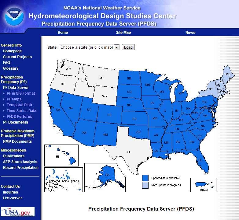
5 Rainfall Frequency 5 Rainfall frequency information in Section 5600 is derived from: NOAA Technical Memorandum NWS HYDRO-35 (1977) for durations 60 minutes U.S. Weather Bureau Technical Paper 40 (1961) for durations > 60 minutes NOAA published new rainfall frequency estimates for Kansas and Missouri in 2014: in NOAA Atlas 14, Volume 8 on NWS Precipitation Frequency Data Server
6

7 Specify Location

8 Rainfall estimates for certain durations and AEPs

9 Rainfall estimates for certain durations and ARIs

10 100-year, 24-hour rainfall OLD: TP-40

11 100-year, 24-hour rainfall NEW: Atlas 14

12 100-year, 24-hour rainfall for Kansas City area NEW: Atlas 14
13 Comparison of Old and New Estimates of 100-Year Rainfall Depths Lee s Summit (NE Scruggs Road & Blackwell Road)
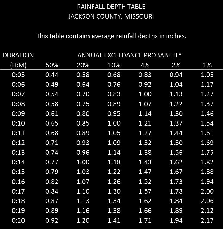
14 Problems Rainfall frequency information in Section 5600 is outdated. Atlas 14 estimates: few durations; excessive spatial variation Solution New Atlas 14-based rainfall depth and intensity tables and equations by county: Buchanan, Cass, Clay, Jackson, Johnson, Leavenworth, Miami, Platte, Ray & Wyandotte
15
16 16 Lag Time and Time of Concentration Objective Reliable T L and T C relationships for KC-area urban watersheds Must account for channel condition (enclosed/paved vs. natural) Approach Determine lag times for KC-area urban watersheds from ALERT data Develop equation for T L the accounts for relevant watershed characteristics Calibrate T L equation with KC-area data T C = 5/3 T L

17 17 30 gaged watersheds Sizes: 113 ac to 11 mi 2 Lag times: 6 min to 2 hr
18 18 Relevant watershed characteristics A = drainage area L = length of longest flow path S = average slope of longest flow path R c = channel development ratio (% enclosed or paved) R i = impervious area ratio (impervious area / total area) W = A/L = average width of watershed
19 Calibrated lag-time equation for urban watersheds in KC area 19
20 Predicted T L (min) Observed T L (min) New equation Old equation 1:1 Line

21 21 Rational Method in Section 5600 Q = K C i A where C = R i R i = impervious fraction C = area-weighted average of 0.3 for pervious surfaces and 0.9 for impervious surfaces. K factor effectively increases composite C for AEP < 10%
22 22 Objective Calibrate frequency-dependent C value (K C in Section 5600) for KC-area pervious surfaces (urban green space and undeveloped land) Approach Regional flood-frequency analysis of 28 USGS-gaged watersheds in KC area Calibrated C to match discharge estimates from regional regression equations Used NOAA Atlas 14 rainfall estimates
23 K C for undeveloped land in the KC area 23
24 Q (cfs) Calibration of K C for AEP = 10% K C = 0.48 (least-squares fit) 1000 K C = 0.30 (Section 5600) i A (acre-inch per hour)
25 25 Recommended changes to rational method in Section 5600 Omit K factor from rational equation For impervious surfaces, retain C = 0.9 For pervious surfaces, use these frequency-dependent C values: AEP 50% 20% 10% 4% 2% 1% C
26 26 Runoff Curve Numbers in Section 5600 Section 5600 specifies a CN value of 74 for all pervious surfaces in KC area. Objective Calibrate frequency-dependent CN values for pervious surfaces in KC area Approach Regional flood-frequency analysis of 28 USGS-gaged watersheds in KC area Calibrated CN to match discharge estimates from regional regression equations Used NOAA Atlas 14 rainfall estimates of 24-hour rainfall in NRCS Type II storm
27 27 Average CN values for undeveloped land in KC area, calibrated for peak flow: AEP 50% 20% 10% 4% 2% 1% CN These values are lower than expected. Why?
28 28 Recommended changes to CN values in Section 5600 None. The specified CN value of 74 for pervious surfaces appears to be appropriately conservative for all frequencies.
29 29 Summary of Recommendations Adopt new county rainfall tables based on NOAA Atlas 14 Adopt new calibrated equations for lag time and time of concentration Adopt calibrated frequency-dependent rational C values for pervious surfaces No change to specified CN values
A NEW SEMI-ANALYTICAL LAG-TIME EQUATION FOR APPLICATIONS IN THE KANSAS CITY METROPOLITAN AREA. Ricardo A. Gamarra Zapata
 A NEW SEMI-ANALYTICAL LAG-TIME EQUATION FOR APPLICATIONS IN THE KANSAS CITY METROPOLITAN AREA By Ricardo A. Gamarra Zapata Submitted to the graduate degree program in Civil, Environmental and Architectural
Runoff Hydrographs. The Unit Hydrograph Approach
 Runoff Hydrographs The Unit Hydrograph Approach Announcements HW#6 assigned Storm Water Hydrographs Graphically represent runoff rates vs. time Peak runoff rates Volume of runoff Measured hydrographs are
INFLOW DESIGN FLOOD CONTROL SYSTEM PLAN PLANT BARRY ASH POND ALABAMA POWER COMPANY
 INFLOW DESIGN FLOOD CONTROL SYSTEM PLAN PLANT BARRY ASH POND ALABAMA POWER COMPANY Section 257.82 of EPA s regulations requires the owner or operator of an existing or new CCR surface impoundment or any
Peak discharge computation
 Ia/P 4 Peak Dischage Method Graphical Peak Discharge Method This chapter presents the Graphical Peak Discharge method for computing peak discharge from rural and urban areas. The Graphical method was developed
Engineering Hydrology Class 3
 Engineering Hydrology Class 3 Topics and Goals: I.Develop s (estimate precipitation) II.Develop simple constant intensity design storm III.Develop SCS design storm Ocean s Why do we want to derive the?
APPENDIX IV. APPROVED METHODS FOR QUANTIFYING HYDROLOGIC CONDITIONS OF CONCERN (NORTH ORANGE COUNTY)
") APPENDIX IV. APPROVED METHODS FOR QUANTIFYING HYDROLOGIC CONDITIONS OF CONCERN (NORTH ORANGE COUNTY) Hydromodification design criteria for the North Orange County permit area are based on the 2- yr, 24-hr
APPENDIX IV. APPROVED METHODS FOR QUANTIFYING HYDROLOGIC CONDITIONS OF CONCERN (NORTH ORANGE COUNTY) Hydromodification design criteria for the North Orange County permit area are based on the 2- yr, 24-hr
NRCS Hydrology methodology review Minnesota NRCS recommendation MnDOT recommendation Using Atlas 14 with HydroCAD
 Dec, 2015 NRCS Hydrology methodology review Minnesota NRCS recommendation MnDOT recommendation Using Atlas 14 with HydroCAD NRCS - Natural Resource Conservation Service (formerly known as SCS Soil Conservation
TECHNICAL MEMORANDUM. SUBJECT: Determination of watershed historic peak flow rates as the basis for detention basin design
 TECHNICAL MEMORANDUM FROM: Ken MacKenzie and Ryan Taylor SUBJECT: Determination of watershed historic peak flow rates as the basis for detention basin design DATE: June 7, 2012 The purpose of this memorandum
Chapter 6. Hydrology. 6.0 Introduction. 6.1 Design Rainfall
 6.0 Introduction This chapter summarizes methodology for determining rainfall and runoff information for the design of stormwater management facilities in the City. The methodology is based on the procedures
Overview of NRCS (SCS) TR-20 By Dr. R.M. Ragan
 TR-20 By Dr. R.M. Ragan") Overview of NRCS (SCS) TR-20 By Dr. R.M. Ragan TR-20 is a computer program for the simulation of runoff occurring from a single storm event. The program develops flood hydrographs from runoff and routes
Overview of NRCS (SCS) TR-20 By Dr. R.M. Ragan TR-20 is a computer program for the simulation of runoff occurring from a single storm event. The program develops flood hydrographs from runoff and routes
Summary of Detention Pond Calculation Canyon Estates American Canyon, California
 July 15, 2015 Bellecci & Associates, Inc Summary of Detention Pond Calculation Canyon Estates American Canyon, California 1. Methodology: Method: Unit Hydrograph Software: Bentley Pond Pack Version 8i
HYDROLOGIC MODELING CONSISTENCY AND SENSITIVITY TO WATERSHED SIZE
 HYDROLOGIC MODELING CONSISTENCY AND SENSITIVITY TO WATERSHED SIZE by James C.Y. Guo. Professor, Civil Engineering, U. Of Colorado at Denver, James.Guo@cudenver.edu.. And Eric Hsu, Project Engineer, Parson
6.0 Runoff. 6.1 Introduction. 6.2 Flood Control Design Runoff
 October 2003, Revised February 2005 Chapter 6.0, Runoff Page 1 6.1 Introduction 6.0 Runoff The timing, peak rates of discharge, and volume of stormwater runoff are the primary considerations in the design
5/11/2007. WinTR-55 for Plan Reviews Small Watershed Hydrology Overview
 WinTR-55 for Plan Reviews Small Watershed Hydrology Overview 1 Overview Course Outline Historical Background Program Description Model Capabilities and Limitations This is the Overview portion of the training.
iswm TM Technical Manual Hydrology:
 : 1.0 2.0 Downstream Assessment 3.0 Streambank Protection 4.0 Water Balance 5.0 Rainfall Tables 6.0 Hydrologic Soils Data Table of Contents 1.0... HO-1 1.1 Estimating Runoff... HO-1 1.1.1 Introduction
Culvert Sizing procedures for the 100-Year Peak Flow
 CULVERT SIZING PROCEDURES FOR THE 100-YEAR PEAK FLOW 343 APPENDIX A: Culvert Sizing procedures for the 100-Year Peak Flow A. INTRODUCTION Several methods have been developed for estimating the peak flood
CHAPTER 3 STORMWATER HYDROLOGY. Table of Contents SECTION 3.1 METHODS FOR ESTIMATING STORMWATER RUNOFF
 CHAPTER 3 STORMWATER HYDROLOGY Table of Contents SECTION 3.1 METHODS FOR ESTIMATING STORMWATER RUNOFF 3.1.1 Introduction to Hydrologic Methods...3.1-1 3.1.2 Symbols and Definitions...3.1-3 3.1.3 Rainfall
Appendix B. Storm Drain System Data
 MENIFEE VALLEY CAMPUS MASTER PLAN FINAL EIR MT. SAN JACINTO COMMUNITY COLLEGE DISTRICT Appendix Appendix B. Storm Drain System Data June 2017 MENIFEE VALLEY CAMPUS MASTER PLAN FINAL EIR MT. SAN JACINTO
1. Stream Network. The most common approach to quantitatively describing stream networks was postulated by Strahler (1952).
.") 1. Stream Network The most common approach to quantitatively describing stream networks was postulated by Strahler (1952). First Order Streams streams with no tributaries. Second Order Streams begin at
1. Stream Network The most common approach to quantitatively describing stream networks was postulated by Strahler (1952). First Order Streams streams with no tributaries. Second Order Streams begin at
Module 3. Lecture 4: Introduction to unit hydrograph
 Lecture 4: Introduction to unit hydrograph (UH) The unit hydrograph is the unit pulse response function of a linear hydrologic system. First proposed by Sherman (1932), the unit hydrograph (originally
Pre/Post Assessment Rubric for Unit: Urban Storm Hydrograph Modeling with the Rational Method for the Urban Desert Southwest USA
 Pre/Post Assessment Rubric for Unit: Urban Storm Hydrograph Modeling with the Rational Method for the Urban Desert Southwest USA 28 September 2012 (revision 3, 16 April 2013) Benjamin L. Ruddell, Arizona
CLARK COUNTY REGIONAL FLOOD CONTROL DISTRICT HYDROLOGIC CRITERIA AND DRAINAGE DESIGN MANUAL
 CLARK COUNTY REGIONAL FLOOD CONTROL DISTRICT HYDROLOGIC CRITERIA AND DRAINAGE DESIGN MANUAL SECTION 600 STORM RUNOFF TABLE OF CONTENTS 601 INTRODUCTION 603 601.1 - Basin Characteristics 603 602 TIME OF
Runoff Processes. Daene C. McKinney
 CE 374 K Hydrology Runoff Processes Daene C. McKinney Watershed Watershed Area draining to a stream Streamflow generated by water entering surface channels Affected by Physical, vegetative, and climatic
Table of Contents. Overview... 1
 Chapter 3 Chapter 3 Table of Contents Overview... 1 Rainfall... 2 3-2-1 Rainfall Depths and Intensities... 2 3-2-2 Design Storm Distribution for Colorado Urban Hydrograph Procedure (CUHP)... 5 3-2-3 Temporal
Pre-Treatment Bioretention Cells Bioswales IOWA STORMWATER MANAGEMENT MANUAL DECEMBER 16, 2015
 Pre-Treatment Bioretention Cells Bioswales IOWA STORMWATER MANAGEMENT MANUAL DECEMBER 16, 2015 Urban Runoff Background How we got here What Problem?? Provenance of the Problem Unified Sizing Criteria What
Section 600 Runoff Table of Contents
 Section 600 Runoff Table of Contents 601 INTRODUCTION...600-1 602 RATIONAL METHOD...600-1 602.1 Rational Method Formula...600-2 602.2 Time of Concentration...600-2 602.3 Intensity...600-4 602.4 Runoff
Chapter 6 Hydrology TABLE OF CONTENTS CHAPTER 6 - HYDROLOGY
 Chapter 6 Hydrology TABLE OF CONTENTS CHAPTER 6 - HYDROLOGY... 6-1 6.1 Introduction... 6-1 6.1.1 Objective... 6-1 6.1.2 Definition... 6-1 6.1.3 Factors Affecting Floods... 6-1 6.1.4 Sources of Information...
Preliminary Drainage Analysis
 Preliminary Drainage Analysis Tanimura and Antle Employee Housing Town of Spreckels County of Monterey, California LIB150205 May 29, 2015 Prepared For: Tanimura and Antle Produce Prepared By: 9699 Blue
SAN GORGONIO PASS CAMPUS - PHASE I
 SAN GORGONIO PASS CAMPUS - PHASE I Banning, CA DRAINAGE STUDY June 16, 2010 Reference 106-195 PREPARED BY: Encompass Associates, Inc. 5699 Cousins Place Rancho Cucamonga, CA 91737 909-684-0093 Fax-909-586-6979
STORMWATER RUNOFF MODELING IMPACTS OF URBANIZATION AND CLIMATE CHANGE
 STORMWATER RUNOFF MODELING IMPACTS OF URBANIZATION AND CLIMATE CHANGE Anne Blair,* Denise Sanger, A. Frederick Holland, David White, Lisa Vandiver, Susan White Development pressure throughout the coastal
I(n)Kn. A Qp = (PRF) --- (8) tp Where A is the watershed area in square miles and PRF is the unit hydrograph peak rate factor.
Kn. A Qp = (PRF) --- (8) tp Where A is the watershed area in square miles and PRF is the unit hydrograph peak rate factor.") AN ALTERNATE APPROACH FOR ESTIMATING SCS UNIT HYDROGRAPH PEAK RATE FACTORS (PRFS) IN SOUTHWEST FLORIDA Himat Solanki Southwest Florida Water Management District 115 Corporation Way, Venice, Florida 34292
AN ALTERNATE APPROACH FOR ESTIMATING SCS UNIT HYDROGRAPH PEAK RATE FACTORS (PRFS) IN SOUTHWEST FLORIDA Himat Solanki Southwest Florida Water Management District 115 Corporation Way, Venice, Florida 34292
4.1 General Methodology and Data Base Development
 Chapter 4 METHODOLOGY 4.1 General and Data Base Development This report project utilized several computer software models and analysis techniques to create the numeric data on which decisions for this
Project Drainage Report
 Design Manual Chapter 2 - Stormwater 2A - General Information 2A-4 Project Drainage Report A. Purpose The purpose of the project drainage report is to identify and propose specific solutions to stormwater
HYDROLOGY REPORT HEACOCK & CACTUS CHANNELS MORENO VALLEY, CALIFORNIA NOVEMBER 2005 REVISED APRIL 2006 REVISED AUGUST 2006
 HYDROLOGY REPORT HEACOCK & CACTUS CHANNELS MORENO VALLEY, CALIFORNIA NOVEMBER 2005 REVISED APRIL 2006 REVISED AUGUST 2006 RIVERSIDE COUNTY FLOOD CONTROL AND WATER CONSERVATION DISTRICT TABLE OF CONTENTS
Section 500 Rainfall Table of Contents
 Boulder Storm Drainage Criteria Manual Section 5 Rainfall Table of Contents 51 INTRODCTION... 5-1 52 INTENSITY-DRATION CRES FOR RATIONAL METHOD... 5-1 53 COLORADO RBAN HYDROGRAPH PROCEDRE RAINFALL HYETOGRAPHS...
DRAINAGE CRITERIA MANUAL (V. 1) RUNOFF
 RUNOFF") Section CONTENTS Page RO- 1.0 OVERVIEW... 1 2.0 RATIONAL METHOD... 3 2.1 Rational Formula... 3 2.2 Assumptions... 4 2.3 Limitations... 4 2.4 Time of Concentration... 5 2.4.1 Initial Flow Time... 5 2.4.2
Section CONTENTS Page RO- 1.0 OVERVIEW... 1 2.0 RATIONAL METHOD... 3 2.1 Rational Formula... 3 2.2 Assumptions... 4 2.3 Limitations... 4 2.4 Time of Concentration... 5 2.4.1 Initial Flow Time... 5 2.4.2
Rhode Island Stormwater Design and Installations Standards Manual
 Rhode Island Stormwater Design and Installations Standards Manual Public Workshop Required Management Volume Calculations and Redevelopment Considerations March 22, 2011 Presentation Outline Recap of How
Overland Flow Time of Concentration on Very Flat Terrains
 Overland Flow Time of Concentration on Very Flat Terrains Ming-Han Li and Paramjit Chibber Two types of laboratory experiments were conducted to measure overland flow times on surfaces with very low slopes.
Rainfall - runoff: Unit Hydrograph. Manuel Gómez Valentín E.T.S. Ing. Caminos, Canales y Puertos de Barcelona
 Rainfall - runoff: Unit Hydrograph Manuel Gómez Valentín E.T.S. ng. Caminos, Canales y Puertos de Barcelona Options in many commercial codes,, HMS and others HMS Menu Transform method, User specified,
APPENDIX A: STORMWATER HYDROLOGY
 APPENDIX A: STORMWATER HYDROLOGY In low impact development (LID), the objective of stormwater control measures (SCMs) is to mimic or replicate the hydrologic function of a natural system. This approach
Gwinnett County Stormwater System Assessment Program
 Gwinnett County Stormwater System Assessment Program Jonathan Semerjian, PE Dept. of Water Resources Stormwater Management Sam Fleming, PE Dewberry Presentation Overview Project Background Drivers Enhanced
Norman Maclean Snowmelt Flow rate Storm flows fs (c flow m a tre S
 Eventually, all things merge into one, and a river runs through it. Norman Maclean Understanding Streamflow ADEQ SW Short Course June 13, 213 Phoenix, AZ Hydrographs Discharge (Q) USGS flow data & plots
ND Detention Project Development Update
 ND Detention Project Development Update Upper Red River Basin Halstad, MN = 8 Upstream Subwatersheds Fargo, ND = 3 Upstream Subwatersheds Halstad, MN Fargo, ND Wild Rice Otter Tail Bois de Sioux Upstream
Water Quality Design Storms for Stormwater Hydrodynamic Separators
 1651 Water Quality Design Storms for Stormwater Hydrodynamic Separators Victoria J. Fernandez-Martinez 1 and Qizhong Guo 2 1 Rutgers University, Department of Civil and Environmental Engineering, 623 Bowser
Simple Method for Estimating Phosphorus Export
 Appendix L Simple Method for Estimating Phosphorus Export 1. The Simple Method The Simple Method is a technique used for estimating storm pollutant export delivered from urban development sites. The method
City of Oakland. Public Works Agency Standards STORM DRAINAGE DESIGN GUIDELINES. Engineering Design & ROW Management Division
 City of Oakland PUBLIC WORKS AGENCY 250 FRANK H. OGAWA PLAZA 4 TH FLOOR OAKLAND, CALIFORNIA 94612 (510) 238-3437 FAX (510) 238-7227 TTD (510) 238-3254 Public Works Agency Standards STORM DRAINAGE DESIGN
Updated Rainfall Coefficients for Texas The EBDLKUP-NEW.XLS Tool
 442 Updated Rainfall Coefficients for Texas The EBDLKUP-NEW.XLS Tool Cristal C. Tay 1, Caroline M. Neale 1, George R. Herrmann 2, and Theodore G. Cleveland 3 1 Graduate Research Assistant, 2 Postdoctoral
Software Applications for Runoff Hydrological Assessment
 Bulletin UASVM Horticulture, 67(2)/2010 Print ISSN 1843-5254; Electronic ISSN 1843-5394 Software Applications for Runoff Hydrological Assessment Severin CAZANESCU 1), Sorin CIMPEANU 1), Oana GUI 2), Dana
SWMM5 LID Control for Green Infrastructure Modeling
 SWMM5 LID Control for Green Infrastructure Modeling Ohio Water Environment Association Collection Systems Workshop Matt McCutcheon, E.I. Water Resources Engineer CDM Smith May 9, 2013 11:15 AM 11:45 AM
Comparison of Predicted and Observed Flood Flows in Pajarito Canyon Following the 2000 Cerro Grande Fire
 University of New Mexico UNM Digital Repository Water Resources Professional Project Reports Water Resources 12-12-2008 Comparison of Predicted and Observed Flood Flows in Pajarito Canyon Following the
Inflow Design Flood Control System Plan
 Inflow Design Flood Control System Plan For Compliance with the Coal Combustion Residuals Rule (40 CFR Part 257) Valmont Station - CCR Surface Impoundments Public Service Company of Colorado Denver, Colorado
Index. Page numbers followed by f indicate figures.
 Index Aerodynamic method, 103, 110 111 Algae, 131, 173, 175 Alternate depth, 88 Alternating block method, 132, 140 141 Attenuation, 106, 107f, 118, 120 Page numbers followed by f indicate figures. Baseflow
Chapter 3 Calculating the WQCV and Volume Reduction
 Contents 1.0 Introduction... 1 2.0 Hydrologic Basis of the WQCV... 1 2.1 Development of the WQCV... 1 2.2 Optimizing the Capture Volume... 3 2.3 Attenuation of the WQCV (BMP Drain Time)... 4 2.4 Excess
EFFECT OF UPSTREAM DEVELOPMENT ON THE CLEAR CREEK AREA
 EFFECT OF UPSTREAM DEVELOPMENT ON THE CLEAR CREEK AREA Technical Memorandum Farming in the Floodplain Project Prepared for May 2017 PCC Farmland Trust Photo credit: Google Earth TABLE OF CONTENTS Page
STORMWATER MANAGEMENT: Emerging Planning Approaches and Control Technologies
 STORMWATER MANAGEMENT: Emerging Planning Approaches and Control Technologies Chapter 5 " HYDROLOGIC SYSTEMS " CHAPTER 5 5.1 INTRODUCTION 5.1.1 Training Objectives The objectives of this module are:! to
City of Katy Flood Protection Study (Meeting 3 of 3) October 23, 2017
 October 23, 2017") City of Katy Flood Protection Study (Meeting 3 of 3) October 23, 2017 Phasing of Meetings April Meeting May Meeting October Review of Tax Day Storm Event and Immediate Actions Taken By City Review of Coordination
City of Katy Flood Protection Study (Meeting 3 of 3) October 23, 2017 Phasing of Meetings April Meeting May Meeting October Review of Tax Day Storm Event and Immediate Actions Taken By City Review of Coordination
2. The Integration of Water Quality and Drainage Design Objectives
 Copyright R. Pitt 2003 August 12, 2003 2. The Integration of Water Quality and Drainage Design Objectives Introduction...1 Rainfall and Runoff Characteristics for Urban Areas...2 Small Storm Hydrology...9
LID & Detention Pond Sizing Tool to Address Hydromodification and Water Quality in Clackamas County
 LID & Detention Pond Sizing Tool to Address Hydromodification and Water Quality in Clackamas County Leah Johanson, Water Environment Services February 12 th, 2015 Agenda» WES History/Stormwater Standards»
DRAINAGE PLAN OF NAU S EASTBURN EDUCATION AND GAMMAGE BUILDINGS FINAL PROPOSAL
 MAY 10, 2016 DRAINAGE PLAN OF NAU S EASTBURN EDUCATION AND GAMMAGE BUILDINGS FINAL PROPOSAL Connor Klein, Jiangnan Yi, Yuzhi Zhang, Yi Yang NORTHERN ARIZONA UNIVERSITY NAU Water Buffalo Engineering Table
Suspended Sediment Discharges in Streams
 US Army Corps of Engineers Hydrologic Engineering Center Suspended Sediment Discharges in Streams April 1969 Approved for Public Release. Distribution Unlimited. TP-19 REPORT DOCUMENTATION PAGE Form Approved
2011 LID Symposium. Estimating Annual Runoff Based on the NRCS Runoff Curve Number. Loews Philadelphia Hotel Philadelphia, PA September 25-28, 2011
 Estimating Annual Runoff Based on the NRCS Runoff Curve Number Presented at: 2011 LID Symposium Loews Philadelphia Hotel Philadelphia, PA September 25-28, 2011 Randy Greer, PE Steve Wright, PE Delaware
Trends in Illinois River Streamflow and Flooding
 Trends in Illinois River Streamflow and Flooding H. Vernon Knapp, Interim Director Center for Watershed Science Illinois State Water Survey Institute of Natural Resource Sustainability University of Illinois
Hydrologic Impacts of Exceeding Zoning Ordinances. on Impervious Lot Coverage: TR-55 modeling of three. Zoning Districts in Shippensburg Borough
 Hydrologic Impacts of Exceeding Zoning Ordinances on Impervious Lot Coverage: TR-55 modeling of three Zoning Districts in Shippensburg Borough Practical Exam-Revisions Kristina Everetts November 19, 2013
San Antonio Water System Mitchell Lake Constructed Wetlands Below the Dam Preliminary Hydrologic Analysis
 San Antonio Water System enhancement. This recommendation was based on limited water quality data provided by SAWS and using a free-water surface constructed wetland with approximately 112 acres of wetted
History of Model Development at Temple, Texas. J. R. Williams and J. G. Arnold
 History of Model Development at Temple, Texas J. R. Williams and J. G. Arnold INTRODUCTION Then Model development at Temple A long history (1937-present) Many scientists participating in: Data collection
Storm Sewer Design. Bob Pitt University of Alabama and Shirley Clark Penn State Harrisburg
 Storm Sewer Design Bob Pitt University of Alabama and Shirley Clark Penn State Harrisburg Major floods are dramatic and water flow routes must be recognized when minor drainage systems fail. These types
Hydrology for Folsom Dam Water Control Manual Update
 Hydrology for Folsom Dam Water Control Manual Update Brian Walker, EIT Civil Engineer, Hydrology Section U.S. Army Corps of Engineers Sacramento District 1325 J Street Sacramento, CA 95816 Tel: (916) 557-7376
Fort Leonard Wood, Missouri. September 2013
 Fort Leonard Wood, Missouri September 2013 1 Presenters Shannon Kelly, Physical Scientist Clean Water Act Program Manager Directorate of Public Works Environmental Division Environmental Compliance Branch
Runoff and soil loss. (Quantification and modeling of watershed discharge and sediment yield) Kassa Tadele (Dr.Ing) Arba Minch University
 Kassa Tadele (Dr.Ing) Arba Minch University") Runoff and soil loss (Quantification and modeling of watershed discharge and sediment yield) Kassa Tadele (Dr.Ing) Arba Minch University Part I. Runoff Contents 1. Fundamental Concepts 2. Generation of
Runoff and soil loss (Quantification and modeling of watershed discharge and sediment yield) Kassa Tadele (Dr.Ing) Arba Minch University Part I. Runoff Contents 1. Fundamental Concepts 2. Generation of
Hydrologic Model of the Vermilion River Watershed for Streamflow Simulations
 This project was funded through the Illinois Department of Natural Resources and the Illinois State Geological Survey. Illinois State Water Survey Contract Report 2004-0. Hydrologic Model of the Vermilion
Continuous Simulation Modeling of Stormwater Ponds, Lakes, & Wetlands: A BUILT-IN APPLICATION OF PONDS 3.2
 Continuous Simulation Modeling of Stormwater Ponds, Lakes, & Wetlands: A BUILT-IN APPLICATION OF PONDS 3.2 PRESENTED AT THE SFWMD WORKSHOP PRE-DEVELOPMENT VERSUS POST DEVELOPMENT RUNOFF VOLUME ANALYSIS
ATTACHMENT C Design Analysis for Erosion Protection Cover for Piñon Ridge Tailing Cells
 ATTACHMENT C Design Analysis for Erosion Protection Cover for Piñon Ridge Tailing Cells TAILING CELL CLOSURE DESIGN REPORT ENERGY FUELS RESOURCE CORPORATION PIÑON RIDGE PROJECT Summary The primary purpose
San Diego Hydrology Model (SDHM 3.0) Reviewer Workshop. Doug Beyerlein, P.E., P.H., D.WRE Clear Creek Solutions, Inc. Mill Creek, Washington
 Reviewer Workshop. Doug Beyerlein, P.E., P.H., D.WRE Clear Creek Solutions, Inc. Mill Creek, Washington") San Diego Hydrology Model (SDHM 3.0) Reviewer Workshop Doug Beyerlein, P.E., P.H., D.WRE Clear Creek Solutions, Inc. Mill Creek, Washington Clear Creek Solutions Hydrology Expertise Clear Creek Solutions,
San Diego Hydrology Model (SDHM 3.0) Reviewer Workshop Doug Beyerlein, P.E., P.H., D.WRE Clear Creek Solutions, Inc. Mill Creek, Washington Clear Creek Solutions Hydrology Expertise Clear Creek Solutions,
The Islamic University of Gaza- Civil Engineering Department Sanitary Engineering- ECIV 4325 L5. Storm water Management
 The Islamic University of Gaza- Civil Engineering Department Sanitary Engineering- ECIV 4325 L5. Storm water Management Husam Al-Najar Storm water management : Collection System Design principles The Objectives
La Riereta Catchment Sant Boi de Llobregat
 La Riereta Catchment Sant Boi de Llobregat Final Report Team 2 Enrique Amaya (COL) Lilian Yamamoto (BRA) Martín Pez (ARG) Sergio Esquivel (MEX) Instructor: José Macor Summary Contents 1. Introduction...
Stormwater Drainage Manual 2008
 Purdue University Purdue e-pubs Indiana Local Technical Assistance Program (LTAP) Publications Indiana Local Technical Assistance Program (LTAP) 2-2008 Stormwater Drainage Manual 2008 Christopher B. Burke
ABSTRACT MODELING WATER QUANTITY AND WATER QUALITY. Thesis directed by: Associate Professor Glenn E. Moglen
 ABSTRACT Title of Thesis: MODELING WATER QUANTITY AND WATER QUALITY WITH THE SWMM CONTINUOUS STREAMFLOW MODEL UNDER NON-STATIONARY LAND-USE CONDITION USING GIS. William D. Medina Cervantes, Master of Science,
GIS Applications in Water Resources Engineering
 King Fahd University of Petroleum & Minerals City & Regional Planning Department Introduction to Geographic Information Systems Term Paper Presentation GIS Applications in Water Resources Engineering Prepared
Ponds. Pond A water impoundment made by excavating a pit, or constructing a dam or an embankment.
 POND SITE SELECTION AND CONSTRUCTION Uses, Planning, & Design David Krietemeyer Area Engineer USDA-NRCS June 20, 2008 Uses Considerations for Location of Commonly Used Terms Pond A water impoundment made
Larry Hogan, Governor
 Larry Hogan, Governor Note on Document Format This document is formatted for two-sided printing: odd-numbered pages on the right, and evennumbered pages on the left. The center margin is wider than the
ABSTRACT UNCERTAINTY AND SENSITIVITY ANALYSES OF THE MUSKINGUM-CUNGE CHANNEL ROUTING MODEL. Stephen Scott Reid, Master of Science, 2008
 ABSTRACT Title of Thesis: UNCERTAINTY AND SENSITIVITY ANALYSES OF THE MUSKINGUM-CUNGE CHANNEL ROUTING MODEL Stephen Scott Reid, Master of Science, 2008 Thesis directed by: Professor Richard H. McCuen Department
DRAINAGE & DESIGN OF DRAINAGE SYSTEM
 Drainage on Highways DRAINAGE & DESIGN OF DRAINAGE SYSTEM P. R.D. Fernando Chartered Engineer B.Sc.(Hons), M.Eng. C.Eng., MIE(SL) Drainage Requirement of Highway Drainage System Introduction Drainage means
Sizing Criteria Worksheets and Examples
 Appendix B Sizing Criteria Worksheets and Examples This Appendix provides sizing criteria worksheets and examples to illustrate the correct procedures for determining the water quality design flow and
CEE3430 Engineering Hydrology
 CEE3430 Engineering Hydrology Practice Exam (There are multiple practice questions here A 110 min test will likely not have more than four questions) 1. Water Balance Write the water balance as Δ Where
Storm Drain Tritium Discharges RETS/REMP Workshop Roger Tolbert Grand Gulf Jim Key Key Solutions, Inc.
 Storm Drain Tritium Discharges 2005 RETS/REMP Workshop Roger Tolbert Grand Gulf Jim Key Key Solutions, Inc. The Issue Discovery of Measurable H-3 Levels in Yard Storm Drains Not Routine Release Pathway
UNIT HYDROGRAPH AND EFFECTIVE RAINFALL S INFLUENCE OVER THE STORM RUNOFF HYDROGRAPH
 UNIT HYDROGRAPH AND EFFECTIVE RAINFALL S INFLUENCE OVER THE STORM RUNOFF HYDROGRAPH INTRODUCTION Water is a common chemical substance essential for the existence of life and exhibits many notable and unique
CITY OF ROLLA STORMWATER DESIGN STANDARDS
 Revised Nov 07, 2017 4:28 p.m. CITY OF ROLLA STORMWATER DESIGN STANDARDS Prepared by: NTEGRITY Engineering, Inc. 1714 East 10 th Street P.O. Box 700 Rolla, MO 65402-0700 Phone: (573) 341-2100 Fax: (573)
MODELING SEDIMENT AND PHOSPHORUS YIELDS USING THE HSPF MODEL IN THE DEEP HOLLOW WATERSHED, MISSISSIPPI
 MODELING SEDIMENT AND PHOSPHORUS YIELDS USING THE HSPF MODEL IN THE DEEP HOLLOW WATERSHED, MISSISSIPPI Jairo Diaz-Ramirez, James Martin, William McAnally, and Richard A. Rebich Outline Background Objectives
Pennsylvania Stormwater Best Management Practices Manual. Section 3 Stormwater Management Principles, Goals, and a Management Model
 Pennsylvania Stormwater Best Management Practices Manual DRAFT - JANUARY 2005 Section 3 Stormwater Management Principles, Goals, and a Management Model This page intentionally left blank. Section 3 Stormwater
DIVISION V SECTION 5600 STORM DRAINAGE SYSTEMS & FACILITIES
 DIVISION V SECTION 5600 STORM DRAINAGE SYSTEMS & FACILITIES (February 16, 2011) APWA 5600 February 16, 2011 DIVISION V DESIGN CRITERIA 5600 STORM DRAINAGE SYSTEMS & FACILITIES APPROVED AND ADOPTED THIS
CHAPTER 3 HYDROLOGY AND HYDRAULICS 3.1 SCOPE 3.2 COMPUTATION METHODS FOR RUNOFF
 CHAPTER 3 HYDROLOGY AND HYDRAULICS 3.1 SCOPE This section sets forth the hydrologic parameters to be used in computations to determine volumes and peak rates of stormwater runoff as well as the hydraulic
Hydrologic and Hydraulic Analysis Report Mountaineer Plant Bottom Ash Pond Complex New Haven, West Virginia
 Hydrologic and Hydraulic Analysis Report Mountaineer Plant Bottom Ash Pond Complex New Haven, West Virginia September 2015 Terracon Project Number: N4155129 Prepared for: American Electric Power 1 Riverside
SITE DESIGN ENGINEERING, LLC. 11 Cushman Street, Middleboro, MA P: F:
 INTRODUCTION This drainage report was prepared for the proposed site re-development at in Burlington, Massachusetts. The project site is approximately 1.05± acres consisting of approximately 70% impervious
Runoff Volume: The Importance of Land Cover
 Runoff Volume: The Importance of Land Cover Grade Level: 9-12 Time: 1-2 class periods Learning Objectives: - Quantify the volume of water that runs off different land uses in a watershed. - Analyze the
Flood hazard assessment in the Raval District of Barcelona using a 1D/2D coupled model
 9 th International Conference on Urban Drainage Modelling Belgrade 2012 Flood hazard assessment in the Raval District of Barcelona using a 1D/2D coupled model Beniamino Russo, David Suñer, Marc Velasco,
Introduction. Welcome to the Belgium Study Abroad Program. Courses:
 Introduction Welcome to the Belgium Study Abroad Program Courses: AGSM 335: Soil and Water Management BAEN 460: Principals of Environmental Hydrology BAEN 460 / AGSM 335 Combined lecture and HW sessions
Detention Pond Design and Analysis. CE 378 Water Resources Engineering. Contents
 R. Pitt April 12, 2004 Detention Pond Design and Analysis CE 378 Water Resources Engineering Contents Introduction...1 Expected Detention Pond Performance...2 Potential Detention Pond Problems...3 Wet
Bay Area Hydrology Model
 Bay Area Hydrology Model Doug Beyerlein, P.E. Joe Brascher Shanon White Clear Creek Solutions, Inc. www.clearcreeksolutions.com Bay Area Hydrology Model This introductory presentation was given at BAHM
2
 1 2 3 4 5 6 The program is designed for surface water hydrology simulation. It includes components for representing precipitation, evaporation, and snowmelt; the atmospheric conditions over a watershed.
URBAN FLOODING: HEC-HMS
 1.0 Introduction URBAN FLOODING: HEC-HMS -Sunil Kumar, Director, NWA All major ancient civilisations were developed in the river valleys because river served as source of water, food, transportation and