Introduction. Brush Comprehensive Plan Update, What Is It and What Does It Mean?
|
|
|
- Eric Robinson
- 6 years ago
- Views:
Transcription
1 Introduction What Is It and What Does It Mean? The Comprehensive Planning Process is the cornerstone for a community to define land use patterns and public policy into the future. Although planning statutes use the terms master plan and comprehensive plan without distinction, they are not identical products. In Colorado, comprehensive planning generally includes planning for social and economic factors beyond the traditional land use plan. This relative flexibility opened the existing statutory language to allow the community to transcend traditional physical growth policies, and broaden the impact of the comprehensive plan to include issues that reach beyond the physical development of the City of Brush. It is the responsibility of the Planning Commission to adopt a Comprehensive Plan for the physical development of the territory within its municipal boundaries and make recommendations to Morgan County in regards to development within the Three Mile Boundary surrounding the City. More specifically, it is directed to develop a Comprehensive Plan for the general purpose of guiding and accomplishing a coordinated, adjusted and harmonious development of the territory within the municipality which, in accordance with present and future needs, will best promote the public health, safety, morals, order, convenience, prosperity and general welfare of citizens. In preparing a Comprehensive Plan, the Planning Commission is directed to take careful and comprehensive survey and studies of present conditions and future growth in the municipality, with due regard to the City s relationship to the neighboring territories. 1 The Planning Commission is also authorized to plan with respect to areas outside of the boundaries of the municipality that, in the Commission s judgment, bear relationship to the planning of the territory within the City s boundaries. Any Comprehensive Plan that purports to affect territory outside of the boundaries is subject to approval of the County government (in this case Morgan County) over that territory. The Comprehensive Plan is subordinate to land use plans adopted by the County Planning Body with such jurisdiction. 1 Colorado Revised Statutes
2 State statute also requires a municipality approve a Three Mile Plan to provide the foundation for future annexations. 2 The City s Comprehensive Plan effort included planning for the three mile plan area outside of the City s current boundaries (see Section I Vision.) By statutory definition, the Comprehensive Plan shall include the following information: (1) The general location, character, and extent of streets, subways, bridges, waterways, waterfronts, parkways, playgrounds, squares, parks, aviation fields and other public ways, grounds and open spaces; and (2) The general location and extent of public utilities and terminals, whether publicly owned or operated, for water, light, sanitation, transportation, communication, power and other sources. 3 It is important to note that the identification of these public utilities have been restricted by The Homeland Security Act of The Public Process Brush last updated the Comprehensive Plan in 1998 and the City desired a rich public process to build consensus. A creative and comprehensive public process has been the underpinning of the Brush Comprehensive Plan update. The process consisted of the following steps, which are expanded on in the following discussion and described on the following graphic. The public process was framed around a three-meeting format, which is described below: Public Meeting Number One The public participation process began with a Community Potluck in February of The meeting was advertised in the newspaper, posters were distributed throughout the City, and ads ran on the local radio station. The Potluck allowed for members of the community to become exposed to the purpose and scope of the Comprehensive Plan Process and provide feedback regarding the schedule and general direction of the project. In addition, the results of the Community Survey (the methodology and results can be found in a later section) were unveiled to the community. The meeting included a wide variety of visual presentations (land use data, environmental data, results from the Community Survey and a socio-economic profile) in the form of large-format graphics and a PowerPoint presentation. 2 Colorado Revised Statutes Colorado Revised Statutes (c). 2


3 Key pad polling was used to ask the attendees a series of more refined urban design and community forum questions than were included in the Community Survey. The relationship between community values and the community landscape were then used with the key-pad results from the survey questions and results were displayed and mapped instantly using GIS maps, an integrated spreadsheet, and weighted by results. Results from key-pad polling, such as the importance of park proximity and as-needed infrastructure to support future growth, were applied to buffers depicting the existing level of service radius for existing public services. The mean score for each growthefficiency element, as derived from the key-pad polling, was used to weight each element, and the combination of all elements was then depicted in the Growth Efficiency Summary Map (see Section I Visioning ). This became a literal spatial expression of community values about efficient locations for future growth. This same rationale was applied to sensitive lands. A Sensitive Lands Map depicted locations that have problems or hazards, as well as resource lands that might be too sensitive for intensive land uses. By using these analysis products, derived from community values, it became clear where growth should and shouldn t be located as the community grows. Public Meeting Number Two This meeting was an opportunity for citizens to express their personal notion of a landuse future, as well as expressing their views on critical community core values. This is a critical element to achieve high levels of support during any public-planning effort. The core values and the physical plan for the future are a common vision based on shared values, and it became the single-most important tool that that community used to direct future land use and achieve their desired outcome. Gaming is a proven method for collecting citizen input on land use, as well as an ideal approach for teaching participants 3
4 about typical planning dilemmas and the spatial implication of their values. The Chip Game is a tried and tested public-planning exercise that has become a popular means of collecting a broad range of possible futures from citizen participants. These alternatives were a critical element of the educational process for all participants, and the evaluation of these scenarios identified a host of lessons that were applied in the development of a physical plan (See Section I Visioning for the results of the chip game and the ultimate Future Land Use Map). The integration of CommunityViz software with the Chip Game to analyze results became a valuable means to measure the performance of each game, and all chips placed on each game board. Models designed to reflect planning goals and objectives were used to quantify each alternative s performance and create visuals used to facilitate a dialog with all participants. The big idea was to make planning mistakes at an early phase, learn from them, discuss how these mistakes can be avoided and apply all that was learned into a final plan that achieves high performance scores from the CommunityViz predictive models and, ultimately, major support from all participants. Evaluation of Chip Game results using CommunityViz Impact Analysis Software took nearly a month, and this effort was essential to create an informed dialog with participants. For example, walkability was measured in terms of proximity of residents to jobs, recreation, utilities and services. The performance of each Chip Game played was evaluated, and graphics were created to communicate the results at the third public meeting in June of Public Meeting Number Three The last public meeting consisted primarily of a slide-show summary of the Chip Game and Core Values results, a series of questions asking attendees if they agree with interpretations deduced from these results and their level of support for the synthesis plan, which was presented for the first time at this final meeting. Key-pad polling was used to instantly quantify attendees responses. A series of questions related to Chip Game results were presented, and citizens were asked if they agree or disagree with the conclusions. Spatial choices, such as specific locations for specific land uses, were refined as well as qualitative concerns such as the architectural style that might be preferred for public buildings or commercial areas. A draft physical plan was presented to attendees for consideration. Because attendees had been fully engaged since Meeting Number One in shaping community opportunities and constraints, goals and objectives, alternative futures, and the preferred plan, they had a huge ownership in the final product. The integration of a transparent process with tools such as key-pad polling, gaming and 4
5 CommunityViz impact-analysis software dramatically improved the consultant team s ability to demonstrate to participants that they are directly influencing the planning outcome. The larger planning methodology ensured that the Plan was responsive to environmental, social and economic concerns. The Advisory Committee also was given cameras and instructed to take photographs of physical features that appealed to each member, as well as areas and features to be avoided in the future. These were then shared between the Advisory Committee and the consultant team to assist in framing broad urban design objectives. Inventory, Collection and Analysis The inventory and analysis process involved the gathering of information regarding demographics, socio-economic data, physical and environmental features, regional conditions and the results of the Community Survey and Key Pad polling exercises. Analysis of this inventory provided an understanding of the area, its strengths and weaknesses, and the needs of the community to be addressed in the Plan. For ease of use, this data appears in the appropriate element, but the complete socio-economic data report is included within the document. Establishment and Refinement of Goals, Policies, and an Implementation Matrix The establishment of goals and strategies are used in this context to articulate an ideal future situation. In is simplest form, a goal is a statement of values of the citizens of Brush. Goals are considered a desired condition for the future and strategies are specific ways to obtain these goals. The establishment of goals provides the basis for determining alternative land use scenarios and code modifications as necessary. These goals and strategies are summarized in each element are also found within the Implementation Matrix section. The elements addressed in the Plan include the following: 1. Vision 2. Growth of the City 3. Urban Design 4. Housing 5. Transportation 6. Economic Development 7. Public Improvements 8. Parks and Recreation 9. Cultural, Historic, Educational, Tourism and Human Services 10. Environmental 11. Resource Extraction and Development This document is also available from the City of Brush in a PDF file format. 5
6 Section I The Vision A primary goal of the overall Comprehensive Plan, as the process of defining a future growth pattern and urban form for Brush, is often times referred to as Visioning. The consultant team guided the community through a collaborative and creative process that led to a shared community vision and common values. Vision and values statements provide focus, purpose, and direction to the Plan process so that participants collectively achieved a shared vision of the future. A shared community vision (the term used in the Brush Plan is Core Values ), provided an overall set of concepts to guide the planning process. Next, through the three-meeting format described earlier, a Future Land Use Map for the City and the Three Mile Area was developed and is included within this section. It is the guiding tool for defining the future landscape of existing and future urban landscape for the City. The following sections frame the development of this collective vision and the intent of the Map, in the form of goals and strategies, and are further articulated in the separate elements of the Plan. A large format version of the map is included in the back of this document. Stakeholder Interviews An initial step in the Plan process was a series of interviews held between Rock Creek Studio staff and a group of citizens suggested by City Staff, Planning Commission Members and the City Council. The purpose of these interviews was to expose the consultant team to a wide range of individuals to discuss issues facing Brush in a setting more informal that traditional public meeting formats. The stakeholders included members of the agricultural community, the elderly, business professionals, the real estate and lending industry and a group of eight (8) high school students. Primary issues that became apparent during these interviews, and reflected in the Core Values, included the following: - Protection of agricultural uses; - The need to continue to support efforts to assist the elderly and financially challenged; - The safety and educational opportunities afforded to the young; - Protection of water quality; - The continuation and expansion of economic development efforts; - The need for a wider variety of housing types; - The need to finally develop an approach to come to closure regarding the Central School site; - The need to develop meaningful and fiscally responsible mitigation for the floodplain and future development of downtown; - Continue to provide exceptional recreational facilities; - Strive for an efficient growth pattern. 6


7 The Core Values developed by the Citizen Advisory Committee are shown below; Brush! Comprehensive Plan Update 2007 Core Community Values We value the youth of Brush! and its surrounding area, and strive to adopt public policies that nurture our young people and provide opportunities for them to grow and stay in the community. We respect our agricultural community for their historical contribution to the community, their positive economic benefits and their impact on the landscape. We value our existing educational and recreation systems and will ensure their viability, expansion and continued success. We value our existing business community and will continue to support their ability to be sustainable and expand. We realize that the boundaries of the City will likely expand in the future and strive to plan for the future of the City with the best interests of existing and future residents. We respect our elderly population and strive to engage them in the public process and ensure that they have the services necessary for a superior quality of life. We value our historic resources and wish to retain the character of these structures through protection and adaptive re-use where appropriate and fiscally responsible. 7
8 And The Survey Says. The 2007 Community Survey greatly assisted the Working Group in shaping a common vision for the future. The entire survey response rate, methodology and results are compiled within this document, and some of the more telling findings are described below. Most Important Issues The Community Survey asked a very pointed question asking the community to define the five most important issues facing Brush in the next five years. The most important issue articulated in the Community Survey in order of percentage was as follows: 1. Child Care/Early Learning (82%); 2. Water and Sewer Service (57%); 3. Economic Development (53%); 4. Water Rights Acquisition (42%; 5. Improve Downtown Core (42%). As a follow-up question, the community was asked to rank as very important and least important (on a scale from 1 (least important) to 5 (most important) issues facing Brush. The most important issues included the following: 1. Water Quality/Water Quantity (mean = 4.2) 2. Job Opportunities (mean = 3.75) 3. Public Safety (mean = 3.6) 4. Shopping Opportunities (mean = 3.6) 5. Appearance of Town (mean = 3.6) 6. City Services (mean = 3.6) Where Would you Put Your Money? The survey included a question designed to make the community puts it money where it s mouth is. The question included a list of potential budget allocation items and posed the question If you have $ to allocate to public uses and services, how would you allocate these funds? The most common responses based on a dollar figure and the lowest standard deviation was as follows: 1. Water Quality/Quantity; 2. Economic Development; 3. Downtown Improvements; 4. Maintenance of City Facilities; 5. Community Recreation Center. 8
; 4. Friendliness (26%) 5. I was Born Here (25%); 6. More Affordable (22%).")
9 Why Do You Live in Brush? The survey also asks residents Why do you live in Brush? The highest responses included the following: 1. Small Town Atmosphere (57%) 2. To Be with Family (38%); 3. Employment Opportunities (28%); 4. Friendliness (26%) 5. I was Born Here (25%); 6. More Affordable (22%). The Transition from Values to the Landscape A primary objective for the Brush Comprehensive Plan update was to not only develop a policy plan, but ground and transfer those policies to a Future Land Use Map. The process was synthesis of the data gathering phase, the public process and the series of Working Group meetings that were held from December of 2006 to June of Meeting Number One included a series of key pad polling that identified some geographic opportunities and constraints. Fundamental to the development of the Future Land Use Map was a series of land use concepts derived from the key pad polling 9


10 Brush Comprehensive Plan Update, 2007 process. Guiding concepts that were reaffirmed during meetings number two and three included: 1. The retention of the City s small town quality and tight urban form as future growth occurs; 2. The ability to protect agricultural lands at the periphery of the City s boundaries; 3. The orderly extension of existing utilities in a fiscally responsible manner; 4. Utilize existing river frontage for open space, passive and active recreation. The Chip Game Process The Chip Game process began in earnest with the Community Profile Survey to identify the issues discussed above. Meeting Number One identified development opportunities and constraints and the development of a Game Board based on the following geographic drivers for future development: Existing Utility Locations (Water and Sewer); FEMA 100 Year Floodplain; Existing Land Use; 10
11 4. Sensitive Wildlife Habitat; 5. Important Agricultural Lands. The most pertinent maps used to produce the Game Board are included in the back of this section, including the final land use concept plan. A complete Map Atlas was produced consistent with State Statute, and are available for review at City Hall and may be obtained on a compact disk in Adobe PDF format. The Game Board included more area than the Statutory Three Mile Boundary, and was further refined into a GIS grid for participants to place chips which represented differing residential densities, future commercial and industrial locations, park locations, bike and pedestrian connections, etc. In addition to an opening presentation with instructions on producing a Land Use Concept Map, all of the information that had been gathered (socio-economic data, environmental mapping and the community survey results) was available for reference during the Meeting Number Two Chip Game Exercise. Assumptions Several crucial assumptions were made to guide each group in developing the Future Land Use Concept Maps, including the following; 1. The question is not if Brush will grow, but how; 2. The existing annual growth rate of 2% annually is applied out to the year 2030; 3. The Future Land Use Concept Map would adhere to the findings of the Community Survey, the Core Values, the results of key polling during meetings number one, two and three, and the significant/important discussions and conclusions were the outcome of ten (10) meetings with the Working Group. The growth projections to 2030, which were the foundation for the exercise, are discussed later in this document. Primary Conclusions of the Future Land Use Concept Map The Final Map adopted as part of the Comprehensive Plan Update is included in this section. The development of the Map represents a significant departure point for the City in terms of implementing long term planning goals. It essentially grounds all the goals and objectives on the landscape, and provides both the City and the development community a guiding path for the future of both the City and surrounding lands. Several important land use concepts (many borrowed from New Urbanism and Smart Growth concepts) emerge with the Plan: 11
12 1. Growth can easily occur for the next 20 years without consuming the entire Three Mile Growth Area; 2. The City desires a tight future land use pattern which protects the rural character of Brush and protects valuable agricultural lands; 3. The City recognizes that the importance of carefully planning for the three interchanges that provide entrances to the City, and subsequent code modifications shall include some design guidelines for this area. Primary Features of the Land Use Map The Future Land Use Concept Map is included in this section and represents a synthesis of the three (3) maps developed by small groups during Meeting Number Two. It includes the graphic representation of the following concepts: 1. The desire to improve the three entry points to help identify and encourage highway travelers to experience Brush; 2. To retain the existing downtown as a key commercial center for the City; 3. The development and improvement of the South Platte River as an environmental, recreational and educational addition for residents and visitors to Brush; 4. The development of an Agricultural Reserve Zone to protect water quality, the viability of the agricultural community and the rural nature of Brush and its surrounds; 5. The implementation of a Cluster Concept for future growth that includes mixed housing types and the development of neighborhood commercial nodes; 6. The development of an Equestrian Center and Habitat Restoration Zone including the Brush Bay Regional Park along the South Platte River and the riparian areas to the east and south of the City; 7. The development of a Green Avenue that would connect these proposed parks and amenities that include pedestrian, bike and vehicular access to these resources. 8. Future road extensions would adopt a grid network that would be safe, efficient and accomplish the desired urban growth patterns into the future. A series of maps that were used to understand existing land use patterns, growth efficiency, environmental constraints, areas that need additional attention were used to develop the future land use Game Board. These maps are shown below and the final land use concept plan is included in the back slider of this document. 12


13 Section II Growth of the City A primary objective of the Comprehensive Plan process was to not only lay the foundation for policy changes that would create a desired future, but to create a Future Land Use Map that would guide the development of the City to the year Historic Development Patterns Brush has developed, similar to many communities in the same era, with a relatively tight urban growth boundary, a traditional grid street layout, predominantly single-family home development and a well-defined historic downtown. Both the Survey Results and the Key Pad polling reaffirmed the desire to continue this trend as the City expands outward from the existing City limits. In addition, the City has developed an aggressive recreational component that further defines the open space pockets that re-occur throughout the City. Although expanded further on the Future Land Use Map, as well as the Recreation section of the document, residents strongly suggested that this general land use trend continue into the future. Future Growth Projections Rock Creek Studio provided three separate growth projections to be used within the Comprehensive Plan Update. Three likely projections were used; 2.0%, 2.5% and 3.0% annual growth rates. The City currently uses 2.0% percent for future public services demand, which we feel based on trend analysis to be relatively accurate. At a 2.0 percent annual growth rate, the City of Brush will double its population within 36 years. It is important to note that this data should be updated on an annual basis to ensure adequate planning for future growth. The comparison of these growth rates are shown on Figure 1. A tighter five-year actual growth rate for Morgan County and municipalities is shown on Figure 2. 13
14 Figure 1 Population Increase Projection Brush Comprehensive Plan 2005 Update, % Increase 2.5% Increase 3% Increase Figure 2 Morgan County Population 30,000 25,000 20,000 15,000 10,000 5,000 Brush MORGAN COUNTY Hillrose Wiggins Log Lane Village Unincorp. Area Fort Morgan 0 April 2000 July 2001 July 2002 July 2003 July 2004 July

15 The Future Land Use Map presented in Section II was analyzed and can easily accommodate nearly 40 years of growth within the Three Mile Boundary. Housing Types Figure 3 summarizes the existing housing mix based on the 2000 Census. Nearly 70% of all dwelling units are single-family detached units. During the key pad polling as well as the community survey, a key recommendation was to encourage a mix of housing types to allow for a broader housing market beyond the traditional housing mix. Figure 3 Housing Types 2000 Census 5% 5% 3% 3% 4% 7% 6% 67% 1 Unit,Detached 1 Unit Attached 2 Units 3 or 4 Units 5-9 Unitsd 10 to 19 Units 20 or More Units Mobile Homes GOAL 1: Encourage and accommodate efficient and fiscally responsible growth consistent with the adopted three mile and future land use map. 1.1: The City shall consider annexation of properties contiguous to the City limits where it is consistent with the goals, policies and strategies of the Brush Comprehensive Plan Update of
16 1.1.1: Maintain accurate records of infrastructure capacities and locations including infrastructure capacities and locations including water and sewer capacity analysis : Encourage utilizing available land within the City limits before expanding City boundaries : In general, discourage flagpole annexations and leapfrog development. However, flagpole annexations may be used to solve problems with existing development in the planning area. Promote annexations of land immediately adjacent to existing city limits : Annexation of enclaves shall be fiscally responsible and not overburden existing taxpayers and be consistent with applicable policies and regulations : The City shall consider using special districts to finance public improvements in existing developments requesting annexation as long as the special district is administrated by the City : All future annexations shall have infrastructure installed to City standards as part of the annexation process. 1.2: Ensure that development in the Brush! Planning area is guided toward the City : Cooperate with Morgan County to develop an intergovernmental agreement and/or a Memorandum of Understanding that recognizes and implements the recommendations of the Brush Three Mile Plan : Actively review and comment on proposed development within the Brush Planning area consistent with an adopted Memorandum of Understanding and/or an Intergovernmental Agreement between the City of Brush and Morgan County : Develop an economic development strategy and revise existing land use codes to encourage desirable land uses to locate within the City of Brush. GOAL 2: Ensure that areas proposed for annexation are compatible with existing residential, commercial, and industrial neighborhoods. 16
17 2.1: Annexation requests will be reviewed to assure compatibility with existing neighborhoods and the adopted Three Mile Plan and Future Land Use Map : Develop process to include review of the appropriateness of the proposed use, street patterns, and other factors which may impact an existing neighborhood during the annexation review process : Include mitigation actions, such as installation of landscape buffering, trail connections, access points and financial participation with utility extensions/improvements during approval of annexation requests : Discourage annexations that would negatively impact existing neighborhoods or place an undue burden on the City with respect to utility extensions or other public services. 17


18 Section III Urban Design The Community Survey and the resulting debate among the Working group centered on retaining the small town character of the existing City form. The existing grid serves the City well in terms of both vehicular and pedestrian circulation and creating separate enclaves and neighborhoods. Concern was expressed throughout the public process to ensure that the grid extension continue as additional lands are annexed into the City boundaries. This desire is reflected in both the Future Land Use Map as well as a reoccurring theme in the goals, policies and strategies contained throughout the document. Landscaping and Development Standards An initial exercise conducted with the Working Group was called Pictures for Planning. This exercise resulted in significant discussion regarding the need to explore the refinement of landscaping standards, nuisance control, weed control, automobile storage, and dilapidated structures in certain areas within the City. These issues will require significant code revisions to implement the Plan. Particular care will need to be taken to work with individual property owners. Highway Corridor Signage Issues The importance of the primary entry points into the City will also require additional modifications to the City s land use regulations. The potential for development of key parcels along the three interchanges is essential to the future viability and attractiveness of these key properties in the future. The Plan recommends the revision to sign ordinances as well as the potential of conducting site specific Design Guidelines to prepare for the future development of these areas. The success of these efforts will need to insure that the property owners are key participants in these efforts and are active participants in resolving these issues. Historic Preservation The City of Brush is blessed with several historic structures that add to the charm and unique urban 18

19 design quality of the City. The Community Survey, discussions that took place during the public meetings, and discussions within the Working Group all reiterated a desire to retain these structures and provide a mechanism for the revitalization of those that have the most important historic qualities. The Central School is the most visible of these structures and the resolution of its future rehabilitation and adaptive re-use was one of the most debated points during the development of the Plan. Fiscal concerns, appropriate future uses, the overall condition of the buildings infrastructure and the potential asbestos issues are both unknown and troubling to the community. The Plan is proposing to utilize graduate students from the University of Colorado, Department of Environmental Design (planners, architects and engineers) to assist the community within a formal public process to finally resolve the issues surrounding the future of a structure that holds a very important architectural and historical place for the City. GOAL 3: Preserve and enhance Brush's small-town, rural character. 3.1: Require quality design standards for new development and redevelopment : Review and update subdivision regulations and update development standards consistent with the Comprehensive Plan Update of : Develop design guidelines which will include architecture, street layout, sidewalks, access criteria, and alleyways, trail connections, and utilities : Develop and codify landscape guidelines for new commercial, industrial development, annexations and redevelopment : Review sign code standards to address Interstate 76 business signage standards : Review City nuisance regulations relating to weed control, automobile and vehicle storage, noise and dilapidated structures and modify if necessary : Continue supporting the City s urban forestry and tree program. 19
20 3.2: Support redevelopment within existing City limits : Evaluate redevelopment potential within the existing City limits in the context of Comprehensive Plan guidelines and zoning regulations : Investigate and acquire funding from both public and private funding sources for redevelopment projects, including Special Districts where appropriate. 3.3: Support the City s Business Districts : Investigate and acquire funds to implement streetscape and building improvements : Cooperate with Business Districts regarding traffic, utility service and parking issues and fund projects through appropriate sources as the budget allows, grants and public/private partnerships : Review zoning regulations, and modify as necessary relative to mixed uses, vertical zoning, landscaping and other strategies which could assist in keeping the downtown area viable. 3.4: Enhance the aesthetic image of Brush by improving the appearance of entryways and major street corridors : Prepare Design Guidelines for key entryways and corridors which would include landscaping, setbacks, building height, scale and mass of structures, appropriate uses and access : Adopt Design Guidelines and identify funding sources and development standards. 20
21 3.4.3: Encourage sales tax generating uses through the promotion of adaptive reuse of and redevelopment of prime retail locations, defined as properties that are either underutilized or appropriate for redevelopment. 3.5: Encourage the preservation, rehabilitation, maintenance and continued use of historic buildings and landmarks : Identify funding sources to help utilize and maintain historic buildings : Facilitate renovation of historic buildings through the flexible application of zoning and building codes : Carefully analyze the costs associated with renovation of important structures to ensure that any use of public funds is fiscally responsible : Foster and improve the City s relationship with the State Historical Society. GOAL 4: Promote a compatible and functional system of land uses that are consistent with the adopted Comprehensive plan. Strategy 4.1.1: Review and update zoning and subdivision regulations, with a timeline consistent with the implementation matrix included within the Comprehensive Plan : Encourage location of shopping, services, recreation, and educational opportunities within walking distance of residential areas : Ensure compatibility between adjacent land uses : Research and adopt pedestrian friendly sidewalk standards. 21
22 Section IV Housing The demographics of housing in Brush are very similar to cities and towns on the eastern plains of Colorado. Nearly 96% of all residential units within the City are occupied, which reflects a very low vacancy rate. Over 62% of housing units are owner-occupied, indicative of the availability of sufficient rental units with a relatively typical vacancy rate of 4.5%. Housing data derived from the 2000 census are shown below in Table 1. Housing in 2000 Table 1 Housing Characteristics City of Brush Total Housing Units 1,923 Universe: Housing units % of Total SF1 - H1 Occupied 1, % Vacant Units - Total 87 Vacancy Rate (%) 4.5% Average Household Size 2.6 Universe: Housing units SF1 - H3, H12 Owner Occupied Units % of Total Owner Occupied 1, % Vacant Units - For Sale Only 12 Homeowner Vacancy Rate (%) 1.0% Average Household Size 2.8 Universe: Occupied housing units Rental Units SF1 - H4, H5 & H12 % of Total Renter Occupied % Vacant Units - For Rent 30 Rental Vacancy Rate (%) 4.4% Average Household Size 2.4 Universe: Occupied housing units SF1 - H4, H5 & H12 % of Total Vacant Units For rent % For sale only % Rented or sold, not occupied 7 0.4% For seasonal, recreational, or occasional use 4 0.2% For migrant workers - 0.0% Other vacant % Total Vacant % Universe: Vacant housing units SF1 - H5 The majority of homes built in Brush reflected to historic development of the City (prior to 1939) and a relatively significant building cycle that occurred in the 1970s. Home construction by decade is summarized on Figure 4. 22
23 Figure 4 Home Construction by Decade Built 1939 or earlier 424 Built 1940 to Built 1950 to Built 1960 to Built 1970 to Built 1980 to Built 1990 to March 2000 * Occupied Housing Units Affordability An industry standard to understand the affordability of housing in a community is the relationship between median housing prices and average monthly income (AMI). Income distribution is shown on Figure 5. The income bracket with the largest number of individuals is $20,000 to $22,499 and the average per capita income in 1999 was $14,672. The average household income in 1999 was $31,333. Figure 6 uses a common methodology to determine housing affordability. Although somewhat dated, this methodology assigns a housing affordability indices with a score of 100 representing an affordability threshold. The housing affordability indices for Brush in 1999 was 160, suggesting that the median family can afford the median house within the City. The most recent data available to augment the 1999 data was obtained from the State of Colorado. In 2006 the average household income had risen to $34,825 and the average single family home value ranged from $86,500 to $100,500. Applying the same methodology cited in Figure 6, the housing affordability indices has declined to 103. Although this indicates that the median family can still afford a single family home, wages have not kept up with subsequent increases in real estate values. Issues The public process (including public meetings and the Community Survey) framed several broad goals that should be maintained into the future including safe, livable environments, high quality future development, a more diversified housing mix and compatibility of future development. 23
24 Income Distribution Number of Men Figure 5 Income Distribution 1999 Number of Women Total % of Total $1 to $2,499 or loss % 7% 100% $2,500 to $4, % 13% 93% $5,000 to $7, % 18% 87% $7,500 to $9, % 24% 82% $10,000 to $12, % 30% 76% $12,500 to $14, % 33% 70% $15,000 to $17, % 42% 67% $17,500 to $19, % 51% 58% $20,000 to $22, % 60% 49% $22,500 to $24, % 69% 40% $25,000 to $29, % 77% 31% $30,000 to $34, % 86% 23% $35,000 to $39, % 91% 14% $40,000 to $44, % 94% 9% $45,000 to $49, % 96% 6% $50,000 to $54, % 98% 4% $55,000 to $64, % 99% 2% $65,000 to $74, % 99% 1% $75,000 to $99, % 100% 1% $100,000 or more % 100% 0% Total: 1,412 1,116 2, % Universe: Population 16 years and over with earnings * Includes full and part-time. Figure 6 Household Affordability 2000 % that make less % that make than more than SF3 - P82, P84 Owner Occupied Housing Affordability Specified owner-occupied housing units: Median value (Adjusted for Inflation in 2000 $'s) $ 86,500 % of median income necessary to buy the median house 16% Income required to qualify for the median house $ 24,442 Housing Affordability Index: (100 or above means that the median family can afford the median house.)* Universe: Specified owner-occupied housing units SF3 - H76 Income in: 1999 Per capita income $ 14,672 Median household income $ 31,333 Median family income $ 39,094 Universe: Total population, Households, Families SF3 - P82,P53,P77 * Note: The housing affordability figures assume a 20% down payment and that no more than 25% of a family's income goes to paying the mortgage. It is based on an interest rate of 10.01% in 1990 and 8.03% in Use this statistic as a comparative, rather than absolute, measure. 24
25 GOAL 5: Maintain and enhance quality residential environments in Brush! 5.1: Preserve Brush's existing neighborhoods as places that are aesthetically pleasing, safe and livable : Encourage the preservation and renovation of housing in Brush's original neighborhoods : Identify possible programs and adopt programs as necessary to assist low-income homeowners in making necessary repairs to their homes : Maintain the infrastructure in residential neighborhoods : Enforce all housing codes and ordinances enacted to protect the quality and safety of residential neighborhoods. 5.2: Promote high quality new residential neighborhoods which are livable, safe and are an asset to the City. Strategy 5.2.1: Review and revise design standards as needed to encourage development of high quality new housing developments. 5.3: Protect existing and new residential development from encroachment by incompatible land uses : Review zoning designations to ensure that adjacent uses do not adversely impact existing development : Require the use of buffer zones, landscaping, berming and other design techniques to help improve and maintain the integrity of different land uses. 25
26 GOAL 6: Promote the construction of new housing in Brush! to accommodate growth and better meet the demand for housing in the City. 6.1: Encourage City and private sector partnerships to facilitate desirable residential development : The City shall develop regulations and guidelines to promote a variety of desirable housing types : Monitor job creation and the housing market on a regular basis to determine if programs should be started to help promote new/different residential development or existing regulations should be modified : Ensure that the City s infrastructure can support new residential development. GOAL 7: Achieve a mix of housing types and densities in order to meet the diverse needs of the citizens. 7.1: Apply flexible standards to undeveloped residential land to allow a range of residential development (types, densities and price points) : Identify what types of housing are needed in Brush and utilize this information when reviewing zoning and subdivision regulations : Encourage a variety of residential densities in neighborhood designs : Encourage Planned Unit Developments (PUD) which allows a diversity of housing types to be developed in the same area while maintaining high quality living environments. 26
27 7.2: Support efforts to develop moderate-income and special need housing in Brush! 7.2.1: Consider expanding a partnership with the Brush Housing Authority to develop and maintain a diversity of income housing projects : Consider utilizing flexible zoning standards and financial incentives to encourage private development of moderate-income housing. 27
28 Section V Transportation Highways The City of Brush has direct access to two (2) State Highways and one (1) Interstate Highway, State Highway 34, State Highway 71 and Interstate 76. The Colorado Department of Transportation provides a myriad of data associated with both state and interstate highways. Table 2 provides a summary of data associated with geometry, surface condition and functional classification of all three highways that bisect or provide access to the City of Brush. Table 2 Classification and Surface Data Brush Interstate /State Highways Highway Surface Width (feet) Thru Lanes Lane Width (feet) Ride Index (1) Condition (2) Classification (3) Interstate Highway Good Interstate-Urban/Rural Arterial State Highway to 48 2 to Fair to Good Urban-Rural Arterial State Highway to 64 2 to 4 10 to Poor to Fair Urban-Rural Arterial Notes (1) Ride Index is a value of between 0 and 100. A value of 100 indicates smooth rideability. A value of 50 is the threshold that indicates no more remaining service life. (2) Condition represents the overall condition of the roadway in terms of safety, surface condition, striping and access point geometry. (3) Classification represents the definition used by the Federal Highway Administration. An arterial is considered a major roadway for through traffiic in a continious route. Source: Colorado Department of Transportation, Historic Average Daily Traffic Data Historic Annual Average Daily Traffic (AADT) was also collected for both interstate and state highways at locations used by the Colorado Department of Transportation. The AADT represents the annual average daily traffic count for a given segment (total of all vehicles in a year divided by 365 days). The data available for the State is shown in Figures 7 and 8. 28
29 Figure 7 AADT Data ON SH 34, EDISON ST W/O HOSPITAL RD, CR 27, BRUSH ON SH 34, EDISON ST E/O HOSPITAL RD, CR 27, BRUSH 5000 ON SH 34, EDISON ST E/O CUSTER ST, BRUSH ON SH 34, EDISON ST E/O SH 71, COLORADO AVE, BRUSH 2000 ON SH 34 E/O EDMUNDS ST, BRUSH 1000 ON SH 34 W/O SH 71 E JCT, E/O BRUSH AADT_1986 AADT_1987 AADT_1988 AADT_1989 AADT_1990 AADT_1991 AADT_1992 AADT_1993 AADT_1994 AADT_1995 AADT_1996 AADT_1997 AADT_1998 AADT_1999 AADT_2000 AADT_2001 AADT_2002 AADT_2003 AADT_2004 AADT_2005 AADT ON SH 34 E/O SH 34 SPUR, BRUSH Figure 8 AADT Data ON SH 71 S/O E JCT SH 34, E/O BRUSH ON SH 71, COLORADO AVE N/O EATON AVE, BRUSH ON SH 71, COLORADO AVE S/O I-76, BRUSH ON SH 71, COLORADO AVE N/O I-76, BRUSH ON I-76 W/O HOSPITAL RD, CR 27, BRUSH ON I-76 E/O HOSPITAL RD, CR 27, BRUSH AADT_1986 AADT_1987 AADT_1988 AADT_1989 AADT_1990 AADT_1991 AADT_1992 AADT_1993 AADT_1994 AADT_1995 AADT_1996 AADT_1997 AADT_1998 AADT_1999 AADT_2000 AADT_2001 AADT_2002 AADT_2003 AADT_2004 AADT_2005 AADT ON I-76 E/O SH 71, COLORADO AVE, BRUSH Spikes are apparent along the State Highway 34 and Interstate 76 in 2000 and 2001, primarily due to construction projects that diverted traffic. For the most part these highway segments have not experienced significant increases in average daily traffic growth. The most dramatic AADT drop has occurred along Interstate 76 west of Hospital Road with a significant decline 2005 and 2006 due to the repairing and shoulder work associated with work in Interstate 76. It is recommended that the City update this data on a regular basis to understand regional transportation changes and include this information in future County and State funding processes. Local Roadway Conditions Local roadway count data is not available. Future data should be gathered by the City as funding is made available. A reoccurring theme throughout the Comprehensive Plan 29
30 process has been the need to revitalize the downtown core and the need to provide adequate and safe pedestrian flow patterns are included within the recommended goals, policies and strategies. GOAL 8: Provide and maintain a roadway network which meets the access and circulation needs for the community in a safe, economical, and efficient manner. 8.1: Maintain and improve the current condition and Level of Service of roadways within the City of Brush : Continue Brush's emphasis on preventative maintenance of streets to maintain ride quality and street longevity and avoid more costly repairs in the future : Complete identified and approved improvements to Brush! roadways : Encourage new and expanded partnerships with the State and County to encourage that the roads within Brush! are properly maintained : Actively pursue State Transportation Improvement Program (STIP) funds through the involvement of both staff and elected officials in the prioritization process : Actively become involved in the County s prioritization process to ensure that roadways that impact the City s transportation infrastructure are addressed as needed. 8.2: Ensure that new development mitigates their proportional share of impacts on the existing transportation infrastructure : Ensure that the impacts of new development are integrated into the review and approval process : Identify and implement means to improve safety and circulation in the vicinity of major traffic generators. 30
31 8.3: Maintain a roadway classification system of arterials, collectors and local streets that promote appropriate levels of access and traffic volumes, does not adversely impact existing levels of service and is modified as new development occurs. Strategy 8.3.1: Develop an annual process for road classifications and updating traffic volumes and levels of service in a spreadsheet that can be updated easily and provide a method for identifying significant increases in traffic levels to allow for funding of needed improvements. GOAL 9: Develop a Downtown parking and circulation plan to support and enhance the viability of downtown Brush! 9.1: Use the Downtown Enhancement Plan as a guide to revitalize the existing downtown core : Investigate existing turn restrictions in downtown area on circulation and safety, and use available funding sources (STIP, County, General Fund) and require mitigation if necessary from new development. GOAL 10: Support alternative modes of transportation. 10.1: Develop a continuous system of bicycle-pedestrian routes including connections to parks and schools : Where roadway width permits, designate bicycle lanes with signing and striping : Provide for separate bicycle-pedestrian paths in the design of future developments, open spaces, and drainage ways. 31
32 10.2: Encourage and enhance public transportation services for seniors, the disabled, and others who rely on such services : Support and expand existing services providing mobility to Brush residents by carefully analyzing existing automobile, bicycle and pedestrian linkages and prioritize proposed improvements during the City s budget process. 10.3: Promote the Brush! Municipal Airport as a community resource. Strategy : Continue efforts to increase awareness of, and use, of the municipal airport. 32
33 Section VI Economic Development Economic development was also a key theme in the Community Survey and the public meetings held during the Comprehensive Plan process. Although only 10% of households were considered living below the poverty line, the community voiced concern regarding the ability of the City to maintain and attract jobs that pay a living wage. Figure 9 provides a summary of families under the poverty level by household type and Figure 10 shows percent under the poverty line by sex and age. Figure 11 breaks poverty into race by individuals. All of these figures utilize data from 1999, and should be updated when more current information is available. Figure 9 Families Under The Poverty Level Families Under Poverty by Household Type Married Male - No Wife Female - No Husband Number % Number % Number % With related children under 18 years: 30 6% 9 14% 21 17% Under 5 years only 0 0% 4 19% 0 0% Under 5 years and 5 to 17 years 26 16% 0 0% 5 10% 5 to 17 years only 4 2% 5 16% 16 23% No related children under 18 years 6 1% 0 0% 0 0% Total 36 4% 9 11% 21 14% Total (Married, Male and Female) 66 5% Universe: Families Table P90 Note: The percentages above represent the number of families under the poverty line divided by the total number of families in that category. 33
34 Figure 10 Poverty by Sex and Age Percent under Poverty by Sex and Age Under 5 years 13% 15% 5 years 34% 10% 6 to 11 years 7% 10% 12 to 14 years 6% 0% 15 years 0% 14% 16 and 17 years 8% 0% 18 to 24 years 19% 13% 25 to 34 years 7% 11% 35 to 44 years 10% 2% 45 to 54 years 5% 7% 55 to 64 years 18% 7% 65 to 74 years 10% 4% 75 years and over 29% 0% -40% -30% -20% -10% 0% 10% 20% Women Men Figure 11 Poverty by Race Poverty by Race (Individuals) % of Total Number % White % Black - 0% American Indian And Alaska Native - 0% Asian - 0% Native Hawaiian & Other Pacific Islander - Other Race % 2 or more races 12 9% Hispanic Or Latino White not Hispanic Universe: Population for whom poverty status is determined % 201 7% Table PCT075A-I Past Economic Development Efforts In April of 2003, the Downtown Professional Network prepared a Market Analysis and Business Development Strategy for Downtown Brush. The report included a series of recommendations divided into the following broad categories, with the more significant strategies summarized below: 34
35 Business Retention and Expansion 1. Formation of an Organization Committee; 2. Design approaches to package available development properties; 3. Promotion of existing downtown merchants; 4. Economic Restructuring to assist existing and future business retention and formation; 5. Business Recruitment. Identification of Top Prospects Based on a cumulative assessment and analysis of existing and future economic and social conditions within the City, the report identified the following specific business types: 1. Coffee House (in place); 2. Steakhouse; 3. Traditional Retail (sporting goods, gifts, books and stationary, home furnishing and New Era Retail ); 4. Antiques and Collectibles; 5. Custom Crafts. The Plan recommends that during the implementation phase all of these uses be explored through an analysis and possible modification of existing zoning regulations. Priority Action Steps This plan also developed a series of action steps for business development and recruitment strategies that included the following specific suggestions: 1. Review City land use plans, zoning ordinances and development policies to ensure compatibility with Business Development concepts and strategies; 2. Ascertain Internet access options currently available in downtown Brush; explore possibilities for partnerships, telecommunications infrastructure improvements and incentives that could help lure Back Door Retail business prospects; 3. Pursue technical assistance and resources for existing businesses wishing to pursue a Back Door Retail component; 4. Assemble a package of information on incentives available to building and business owners, such as façade /sign improvement grants, low-interest loans and federal/state historic rehabilitation investment tax credits and incentives; 35
36 5. Develop and produce professional quality downtown prospectus materials in print and electronic formats; 6. Identify and pursue for recruitment of specific businesses that correspond to the Top Prospect characteristics; and 7. Initiate discussions with the City and Colorado Water Conservation Board to explore options and alternatives for improving drainage and to address floodplain issues that might inhibit future development. Marketing Both the Comprehensive Plan and the Market Analysis work are suggesting a series of marketing steps to assist in additional tourist/regional economic opportunities. Specific actions steps include the following: 1. Work to enhance and maintain existing downtown festivals and events and to introduce new events and activities that are consistent with downtown Brush marketing principles and appeal to targeted market segments; 2. Work with the Brush Rodeo Association, business organizers and owners, and downtown Brush businesses to create cross-marketing opportunities; and 3. Support, promote and facilitate downtown business community cooperative advertising and cross-marketing efforts. Downtown Enhancement Plan A Brush Downtown Streetscape Plan was prepared by Landscape Architect Julie Wolverton in December of 2004, and the Working Group and the community appear to still support the approach depicted on Figure 12. The primary goals of this effort include the following general urban design strategies: 1. Identify downtown Brush as a destination site with significant signage at I-76 interchanges and on vehicular scale directional signs; 4 2. Create a strong downtown identity in a 2-block area along Clayton Street between North Railway Street and Edmunds Street with streetscape, art, planters, signage, site furniture, lighting and human scale spaces; 4 It is important to note that many of these design notions are reflected on the Future Land Use Map presented in Section II of this document. 36
37 GOAL 3. Link downtown north with the redevelopment of the Central School site. Tie into the Green Boulevard as shown on the Future Land Use Map; 4. Link downtown south across the railroad tracks to the Memorial and Prairie Trails Parks on South Clayton Street; 5. Utilize local sales barns and auction houses to highlight with an information kiosk, brochures, and discount coupons to downtown shops; 6. Slow down traffic near downtown with traffic-calming features and safe pedestrian zones; 7. Encourage visitors to park and walk downtown. 11: Continue to develop a diversified and stable economic base that provides Brush residents with a variety of job opportunities. 11.1: Maintain/Continue to support a business environment that encourages existing businesses and industries to remain in Brush, grow, and continue to be successful while providing benefits to the City and its citizens : Pursue efforts to develop mutually beneficial and cooperative relationships between the City and existing businesses and industries : Support an active Chamber of Commerce that provides a variety of services to members and the community. 11.2: Continue efforts to attract desirable businesses and industries to Brush : Develop and support economic development programs which identify and recruit businesses that provide a living wage, increase sales and property tax revenue, and are environmentally responsible to locate in Brush : Strengthen partnership between economic development organizations in Brush and Morgan County to promote economic health. 37
38 11.2.3: Annually assess the effectiveness of efforts to strengthen these partnerships and implement changes if necessary to ensure success : Maintain City s infrastructure and utility capabilities to ensure that new businesses and industries have readily available services (water, sewer and transportation infrastructure and availability) : Support private efforts to prepare buildable sites for new businesses and industries : Emphasize maintenance and improvement of amenities that make Brush a desirable place to live and do business, including quality of life, distance from urban areas and access to recreational opportunities : Consider offering incentives to businesses considering locating to Brush consistent with the City s Incentive : Consider development impacts on quality of life, i.e. public safety, housing, education, utility services, etc. when recruiting new businesses, and develop a set of target businesses that are consistent with the adopted Comprehensive Plan : Continue to support and coordinate the Economic Stakeholders Group :Continue building Community Enhancement Funds to support Economic Development efforts :Actively pursue the implementation of both the Brush Downtown Streetscape Plan (2004) and the \Market Analysis and Business Development Strategy (2003) : Identify and promote the redevelopment of existing Brownfield Sites. GOAL 12: Achieve an adequate mix of commercial development that meets the needs of Brush citizens and does not excessively impact the City s transportation system. 12.1: Support and promote the Downtown commercial area as strong retail and service center. 38
39 12.1.1: Enhance the appearance of the downtown area and usage through historic preservation, signage, streetscape improvements and design features : Support efforts to diversify businesses located in the downtown area : Investigate means to fund downtown parking, streetscape, and building improvements : Utilize funding sources to implement the Main Street Streetscape Plan and the Downtown Improvement District by prioritizing the most important components of each plan. 12.2: Actively pursue development of I-76 corridor at Hospital Road and N. Colorado Ave., and the north side of Hwy 34 from Hospital Road to west City Limits : Proactively develop street plans in developing commercial and industrial areas that access State Highways to provide adequate access for businesses : Support efforts to provide utility services to I-76 and Hwy 34 building sites Actively pursue funding for the development and installation of access from State Highway 34 west of Hospital Road and north of Exit 90 on Highway : Develop a partnership with the Ditch Company to cross the ditch from State Highway : As the City grows, plan neighborhood commercial areas which are both convenient and compatible with new neighborhoods : Develop design guidelines to ensure that stores and other commercial buildings mitigate their impacts to surrounding neighborhoods : Create zoning regulations to control the types of businesses allowed in neighborhood commercial areas. 39
40 Section VII Public Improvements The City of Brush has continued to spend considerable resources to update needed public improvements. The most recent studies and important findings are summarized below. City of Brush Raw Water Plan This plan was prepared by Applegate Group in March of 2006 guided by the City of Brush Water Advisory Committee. The Committee sought to plan for a long-term, reliable water supply for continued economic growth and protection during periods of drought. The Committee chose a planning horizon of 2026, which was closely aligned with the build-out horizon of the Comprehensive Plan s target of The Committee examined the current water supply and demand of Brush and a variety of ways to meet future water demand using existing and new sources. The Committee divided the City s water supplies into three categories, and assigned the following action steps to be taken. Municipal Water Supply 1. Evaluate opportunities and timeline to shift industrial, non-potable irrigation and other non-municipal use from the municipal well field to other uses; 2. Maintain agreement with Fort Morgan Reservoir Company for recharge to augment up to a maximum sustained depletion for the 2,200 acre feet of pumping; 3. Evaluate the long-term augmentation credit available in the future from the accounting of the 1987 Fort Morgan Reservoir Company Agreement; 4. Investigate the benefits of acquiring additional Fort Morgan Reservoir Company shares if they could supplement the recharge augmentation credit provided by the 1987 agreement; 5. Schedule Kirk Russell from the Colorado Water Conservation Board (CWCB) for a presentation on funding opportunities to purchase shares with documentation provided by a City Council-approved raw water supply plan; 6. Identify ways Upper Platte and Beaver Creek shares could be used for augmentation of the Brush municipal well field and future municipal use with treatment in addition to industrial use; 7. Investigate types and locations of joint water treatment options for future surface or groundwater supplies for municipal and industrial use; 40
41 8. Obtain input from other communities upstream and downstream on the South Platte River to provide additional ideas for cooperation on meeting future water demands; 9. Investigate potential and cost of joining the Southern Water Supply Project with Northern Colorado Water Conservation District (NCWCD); and 10. Investigate methods to generate revenue from water dedicated to industrial users to fund improvements to the municipal well field and acquire additional water supplies. Non-potable Water Supply 1. The City will look for ways to use the farm and park fields or ditch shares for non-potable irrigation instead of water from the municipal well field; 2. Maintain augmentation agreements with Riverside Canal and the Fort Morgan Reservoir Company for the farm and park wells where Brush has the augmentation responsibility; 3. Maintain relationships with the Upper Platte and Beaver (UP&B) and (Lower Platte and Beaver (LP&B) companies for inclusion of the seven farm and park wells in those augmentation plans; 4. Encourage future park and green space areas to use non-potable irrigation sources; and 5. Look for opportunities to purchase additional shares in the ditch companies included in the Riverside Irrigation District and 2002 Morgan Canal Company Agreements to increase the amount of augmentation water available. During the next five years from the adoption of the Raw Water Master Plan, Brush will also: 1. Transfer all park and green space areas currently irrigated by the municipal well field to other non-potable sources like farm and park wells or ditch shares; 2. Determine the extent of the use of augmentation credits from the Riverside Irrigation District and Fort Morgan Reservoir Company agreements and if extensions and/or increase in ditch share ownership in these companies would help the City in the future with augmentation of wells used for non-potable irrigation; 3. Determine if there are any excess Lower Platte and Beaver (LP&B) shares available for non-potable irrigation; and 41
42 4. Determine if any future developed augmentation sources such as recharge of UP&B shares are required to augment pumping for non-potable irrigation by current or future farm and park wells. Industrial Water Supply There are a number of steps that the report also recommends to develop a municipal augmentation and industrial water supply using Upper Platte and Beaver (UP&B) shares, including: 1. Meet with Upper Platte and Beaver Ditch Company representatives and explain its goals for using UP&B shares in the Raw Water Master Plan; 2. Meet and discuss the City s plans to use UP&B shares with Colorado Energy Management (CEM) representatives and look for opportunities to benefit both parties; 3. Discuss the joint ownership of 15 UP&B shares with CEM representatives and their use in the future; 4. Document and evaluate the historic consumptive use of the UP&B shares owned by Brush for use in future water court applications; 5. Inventory and identify potential recharge sites to receive delivery from the UP&B shares; 6. Evaluate and summarize the yield from all the City s current augmentation sources. This information can determine the amount of the additional augmentation credit the City may want to develop from its UP&B shares; 7. Research the market value of UP&B shares; 8. Investigate Colorado Water Conservation Board (CWCB) programs for loans to purchase shares used for municipal water supply identified in the approved Raw Water Master Plan; 9. Prepare a water court application to change of use for other shares that City may acquire over the next five years; 10. Develop a timetable to complete a change of use for other shares the City may acquire over the next five years; 42
43 11. Investigate methods for Brush to recoup its investment in the UP&B shares from industrial users to generate revenue for use in improving the City s municipal water supply; and 12. Meet with the City of Fort Morgan, Morgan County Quality Water District, and the NCWCD to gain information on the options, costs and feasibility of participation in the Southern Water Supply Project pipeline. Wastewater Feasibility Study Integra Engineering prepared a Wastewater Feasibility Study for the City of Brush in September of The report evaluated upgrade opportunities to provide wastewater capacity for population increases to the year 2026, again relatively close to the planning horizon used in the Comprehensive Plan Update of The study analyzed six (6) alternatives. The currently preferred alternative is the Sequencing Batch Reactor Option (SBR) which would have a capital cost of $10.0 million. The SBR process requires larger aeration basins but does not require secondary clarifiers, resulting in lower construction costs than the other alternatives. Construction would occur in phases. Phase I is recommended to occur in 2007 and would focus on design. Completion of construction is projected for Future expansion to meet domestic demand would not be required until after Storm Drainage Master Plan This study was completed by Nolte Engineering in July of The purpose of the report was to update a previous study completed by Carter Burgess in February of 2002 and included consideration of additional alternatives in the study areas and also addressed the area south of the railroad tracts and the vicinity of Mill and Lincoln Streets that were excluded from the 2002 analysis. As part of the previous study, the following problem areas were identified: 1. Clayton Street in the downtown area. This area has experienced frequent flooding streets with excessive ponding in the streets and flooding of adjacent buildings and basements during storm events; 2. Sunset Addition. This area also experiences frequent excessive street flooding and occasional flooding of adjacent residences. The existing Sunset Park retention pond often reaches capacity and reduces the ability of the existing storm sewers to handle flood events; and 3. North Central Area. This area is a low-lying area near the southwest corner of the I-76/North Colorado Avenue interchange. 43
44 In addition, the Nolte Study identified two additional areas that experienced storm water capacity issues; 1. South Railroad Area. This area is located south of the railroad tracks in the downtown area. In this area a 5 rainfall reportedly caused extensive flooding at Knearl Street and South Curtis Street and other nearby areas; and 2. Lincoln/Mill Street. This location along the south side of Mill Street near Lincoln and Ray Streets has experienced frequent flooding at intersections and storm water has backed up into homes. A series of alternative and cost estimates were developed for each area, but specific alternative recommendations have not been selected. The Comprehensive Plan Update recommends that these alternatives be assessed, and final mitigation be selected and a phasing plan be finalized to address the storm water issues identified in both the 2002 and 2006 engineering analysis. Updated Beaver Creek Conceptual Flood Control Plan This report was also completed by Nolte Engineering in November of A large portion of the City of Brush lies within the 100-year floodplain as shown on the current Federal Emergency Management Agency Flood Insurance Rate Map (presented in Section II of this Plan). Three alternatives are described in the Nolte report. The first alternative is the Corps of Engineers levee constructed along the north, east and south sides of the City to prevent flood water from Beaver Creek from entering the downtown. The second alternative is to create channel benches along Beaver Creek in addition to the levee. The third alternative is to widen the bridges along Beaver Creek as well as the channel benching and levee. The cost of Alternative 1 is estimated at over $3 million, and would represent a significant change in the existing landscape. Alternative 2 is estimated at over $22 million, and Alternative 3 is estimated at over $33 million. The report concludes that Alternative 1 is the recommended mitigation measure, although suggests that further design analysis, estimated at over $600,000, be conducted. The Comprehensive Plan update recommends that this analysis be conducted, with careful consideration for the visual impact of the levee be included in the analysis and recommended mitigation of these impacts be considered as well. GOAL 13: Provide public improvements that are designed and installed to deliver required service in a timely manner. 44
45 13.1: Continue to formulate and annually review five year capital improvement program : The City will be responsible for funding public improvements necessitated by obsolescence, changes in City goals or to meet longstanding needs in the City infrastructure : Developers are primarily responsible for public improvement needs generated by growth. In times of rapid growth, development fees may be established to help pay for facilities other than water and sewer systems : Property owners of enclaves or existing development being considered for an annexation are responsible for improving their infrastructure to City standards as part of the annexation process : Create zoning regulations to control the types of businesses allowed in neighborhood commercial areas. 13.2: Ensure a high standard of water and sewer service to all areas of the City : New water and sewer service shall be provided only to properties within the City limits except as otherwise approved by Council : Water and sewer services within Brush! shall only be provided by the City. 13.3: Plan for extension of City infrastructure into City growth areas. Strategy : Develop master plans for major system improvements to growing areas consistent with the adopted Future Land Use Map and Three Mile Plan. 45
46 Section VIII Parks and Recreation Parks and Recreation is an integral part of the Brush community and is actively used by both youth and the elderly. The department oversees the operation of the swimming pool, ball fields and a wide variety of youth programs and is responsible for rentals of the two community buildings and picnic shelters. The department also actively works with the Public Works Department in overseeing the operation of all city parks and also works with the Brush School District in utilizing school facilities for city programs. The most recent data for recreational participation are shown on the following page. GOAL 14: Provide adequate parks and recreation facilities to serve the recreation needs of residents. 14.1: Neighborhood and community parks should be developed or improved to serve the present and future needs of residents based on the existing level of service and the projected needs of the community : Facilities should be designed, within site constraints, to meet the recreational needs of existing and future residents : An analysis shall be conducted to define the City s existing level of service for all recreational programs and facilities to establish a baseline to assess existing and future needs of the community : Future development shall be expected to mitigate its proportional impact on recreational facilities to avoid a decline in the existing level of service provided to residents of the City : Evaluate existing recreational demands and facilities located within the local area. Upgrade and/or add facilities to meet unmet recreational needs : Review and update the existing Parks and Recreation Master Plan to ensure that it is up to date and consistent with the Comprehensive Plan, Future Land Use Map and the Three Mile Plan. 14.2: Park and recreation facilities should provide for both outdoor and indoor recreation opportunities for the community. 46
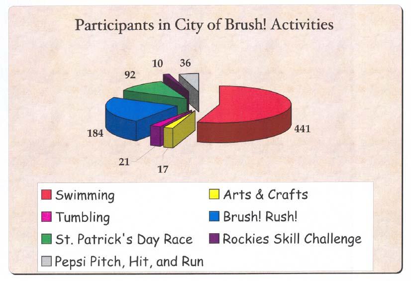

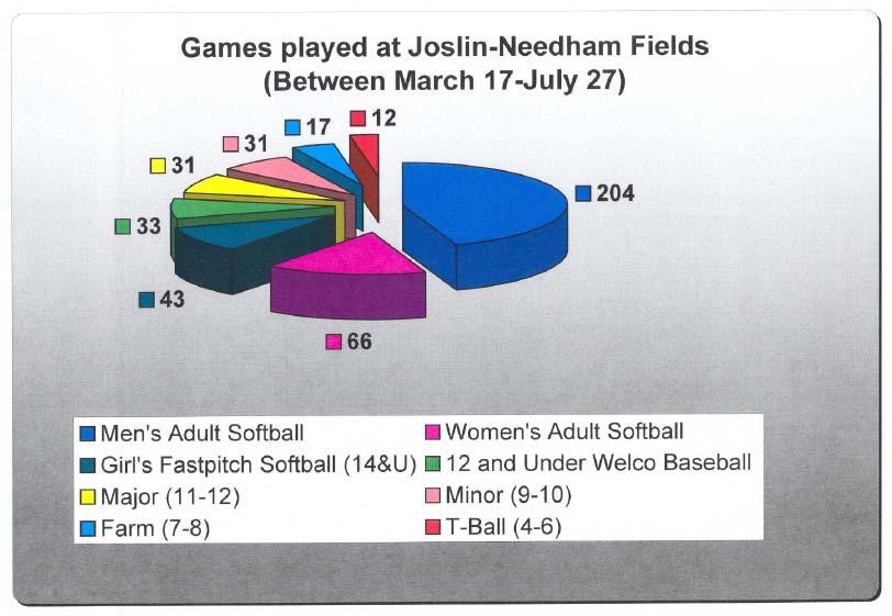
47 2006 Recreation Participation 47
48 Strategy : Encourage cooperation between the City, the School District and other community organizations to allow for joint use of facilities. 14.3: Develop and utilize open space areas for recreation : Develop site design criteria and implement procedures that provide open space requirement for new development : Analyze the feasibility of utilizing the Brush Prairie Ponds and South Platte River riparian areas for open space recreational opportunities. GOAL 15: Develop a comprehensive trails network linking parks, recreational facilities and other community facilities. 15.1: Develop bike routes that provide safe access between schools and parks : Evaluate and implement the potential for the addition of bike lanes to existing streets : Implement opportunities to develop off-street bike routes. 15.2: Utilize drainage ways and irrigation ditches as trail routes through the community : Coordinate trails design with the design of drainage ways : Develop cooperative agreements with ditch companies regarding joint use of ditch right-of-way for trails. 48
49 15.3: Ensure that adult recreation programs pay their own way through fee systems that reflect the true costs of providing adult recreational programs. Strategy : Annually assess fee structures for adult recreation programs to ensure that the fee structure reflects the true cost of staffing, maintenance and all associates costs for providing these programs. 49


50 Section IX Cultural, Historic, Tourism, Educational and Human Services A Short History of Brush Cattle pioneer Jared Brush never lived in the City named for him, but the community caught his enterprising spirit. It produced one of the nation s first nursing homes, Eben-Ezer, which began in 1903 as a tuberculosis sanitarium, and then focused on its groundbreaking work in elder care in the 1920s. Local farmers thrived on sugar beets, dividing their crops between Brush s Great Western Sugar Company factory and area rancher s feedlots. Oil drillers tapped the Little Beaver Field in 1931; by the 1950s it was a gushing nine thousand barrels a day. Brush later boasted Colorado s first pari-mutual racetrack, a half-billion dollar power plant, and a major meat packing plant and it remains a national leader in the care of the elderly. Through it all, the City has remained one of the state s ranching meccas. The Brush Area Museum and Cultural Center is located in the old Knearl School Building, named in honor of William Billy Knearl who donated the land for the school and its construction was completed in After 61 years of service the school was closed. It is located in its original site in what is known as the scenic VFW memorial park. In 1996, the City of Brush gifted the building to the Museum and in 1999 Knearl School was opened as the Brush Area Museum and Cultural Center. The Importance of Early Learning and Child Care The Community Survey asked a series of questions regarding the most important issues facing the City of Brush. One question asked specifically what are the five most important issues facing the City. One interesting finding that has both policy and funding implications is the relative importance of child care and early learning, which nearly eighty percent of all respondents ranked as the most important issue facing the Brush. Figure 13 graphically depicts how important this issue is to residents. 50

51 Figure 13 Importance of Childcare and Early Learning Schools The Thompson Primary School is located at 422 Ray Street. It provides Pre-Kindergarten to 2 nd Grade education and has over 400 students. Its attendance rate is 96.9%. The Beaver Valley Elementary School is located at 420 Glacier Avenue and provides 3 rd to 5 th grade education and has as over 300 students. Its attendance rate is 95.1%. The Brush Middle School is located at 401 Howard and provides 6 th to 8 th grade education and has over 300 students. Its attendance rate is 93.7%. Brush High School is located at 400 West Road and provides 9 th to 12 th grade education and has over 400 students. Its attendance rate is 95.8%. The entire Brush School District RE-2J has over 1,500 total students with a combined attendance rate of 95.4%. 5 Current Community Events Oktoberfest is held the 4 th weekend of September and has an attendance of approximately 6,000. The Brush Rodeo is held July 2nd through the 4 th and has attracted over 20,000 attendees over the three nights. Past events last held in 2006 were a Balloon Festival held 5 Brush Public Schools Re2J Annual Community Report,
52 in September with approximately 100 attendees and a Fiber Arts Festival with approximately 250 attendees. 6 The community has expressed a strong desire for additional events to promote economic activity for the City which was also cited earlier in the Economic Development section of this Plan. GOAL 16: Provide Brush residents with a variety of cultural and special events opportunities. Policies 16.1: Promote community events such as the Brush Rodeo, the Brush Rush 5k and the St. Patrick s Day 5k : Provide City support for community sponsored events : Encourage community involvement in City sponsored events and other community organizations such as the Music Club and the Arts Council : Investigate the feasibility and potential economic benefits of new events to include music, art, festivals etc. and consider funding these events. GOAL 17: Support community educational opportunities. 17.1: Establish City and School district partnerships that lower costs of delivering programs : Encourage the joint use of City and School facilities : Establish an effective relationship with the School District to ensure that common issues (land use, utility services and traffic) have a forum for cooperative discussion and resolution. 6 Attendance based on estimates by the Chamber of Commerce,
53 17.2: Provide support for the East Morgan County Library District. Strategy : Continue to cooperate with the Library District regarding library operations and projects. GOAL 18: Encourage human services and volunteer activities in the community. 18.1: Recognize the importance of care facilities and service groups to the community. Strategy : Encourage cooperation between the City and care facilities and service groups regarding operations and projects. 18.2: Recognize the importance of local foundations to the community. Strategy : Continue to recognize local foundation support for community services and projects. 18.3: Ensure that early learning and child care facilities are expanded in the community. Strategy : Encourage the expansion of child care and early learning facilities within the City. 53
54 Section X Environment Environmental Constraints Early in the planning process Rock Creek Studio and FOREsee Consulting produced a comprehensive mapping atlas of all available Geographic Information System (GIS) system data from a variety of sources including the American Farmland Trust, the State of Colorado, and the Colorado Division of Wildlife. At this time, no data has been obtained from Morgan County, and the Plan is recommending including this data when it becomes available. The Three Mile Plan has no significant slope issues. There are significant areas of riparian avian habitat, which are shown on Figure 14 and are isolated along the South Platte River Corridor. This area is proposed for a regional park to be developed with the Colorado Division of Wildlife (State Park Service). The 100 Year Floodplain also represents a significant constraint to the revitalization of the downtown core, and is shown on Figure 15. Potential mitigation and suggested steps to addressing the floodplain were presented earlier. The existence of large areas of Prime Farmland can be found throughout the Three Mile Planning Area, and are shown on Figure 16. The majority of these areas are shown on the Future Land Use Map as both potential development areas and agricultural reserve areas. The concept favored by the Plan is that individual land owners have both the ability to develop their property consistent with the Future Land Use Map and also remain in agricultural production if that use is still economically viable. In short, the State of Colorado only allows annexation to occur with the support of the land owner. The City has no statutory authority to annex lands without the support and willingness of the property owner. The area surrounding Brush does contain significant wildlife habitat including Pronghorn, a single Bald Eagle nesting site south of the City, and Quail, Ringneck Pheasant and Geese throughout much of the Three Mile Planning Area. None of these species with the exception of the Bald Eagle site are considered endangered. The Bald Eagle Site is shown on the Future Land Use Map as set aside for public uses. GOAL 19: Protect important environmental quality and resources of the City of Brush and surrounding areas including well fields and overall water quality. 19.1: Pursue measures aimed at protecting and improving the environmental quality and resources of the City and surrounding areas. 54
55 19.1.1: Ensure that all applicable standards (local, state and federal) are applied to existing and future industrial development : Actively participate in the National Flood Insurance Program to reduce potential property losses : Actively monitor development, water rights and other activities that may affect the City s well fields : Protect sensitive areas like prime agricultural land, riparian areas, wetlands and wildlife habitat as the City grows : Promote educational programs regarding water conservation measures for residential and commercial land uses (EPA shower reduction devices, low-flow toilet rebates, low water demand landscaping, etc). GOAL 20: Encourage environmentally sound methods of using and disposing solid and hazardous waste. 20.1: Develop programs that encourage residents to reduce, reuse and recycle : Advertise existing drop-off locations for recyclables and pursue options for increasing recycling : Educate residents about ways to reduce, reuse and recycle their solid waste : Continue programs that encourage composting and mulching of green yard waste. 20.2: Develop programs that encourage the proper use and disposal of hazardous waste. Strategy : Support and expand the County s efforts to provide information to residents that explains the proper use and disposal of common household hazardous waste. 55

56 Section XI Resource Extraction and Development and Utility Corridors Mineral extraction in Morgan County as a whole and Brush in particular, has historically risen and fallen with both domestic and world-wide markets. The Colorado Geologic Survey, Department of Natural Resources produces annual summaries and field production data regarding oil and gas production for the entire state, including countylevel production summaries. Unfortunately, Morgan County has very limited geographic information regarding resource extraction. As this data becomes available it should be inserted into this document and changes in policy, if necessary should be implemented. Morgan County does have limited oil and natural gas resources, and the general location of these is shown on Figure 17. As shown, natural gas is the dominant resource in the County and in the general Brush area. Figure 17 State-Wide Oil and Gas Resource Locations County Production Levels 56

57 County Production Levels Data obtained from the Colorado Department of Natural Resources in 2006 found 265 active oil and gas wells in Morgan County. Total barrels of oil extracted in 2006 were 100,380 and 291,204,000 cubic feet of natural gas was extracted from fields in the County. Oil production ranked 15 th and gas production ranked 28 th by County in the state of Colorado. Oil and Natural Gas production by County is shown on Figure 18. Morgan County is considered in the lower tier of total production, but that does not suggest that new resources may not be discovered and developed in the future. Utility Corridors In the last five to seven years the Brush area has seen a spike in development of utility and transmission corridors, notably the Cheyenne Plains Pipeline which transmits natural gas from Colorado to Kansas. As these corridors expand or widen in scope, the City should carefully assess the adequacy of existing permitting processes to ensure the mitigation of impacts, particularly water quality, as well as retaining access to these resources. Figure 18 Oil and Natural Gas Production Value by County Source: State of Colorado Mineral Extraction Database,
RURAL RESIDENTIAL COMMUNITY ROLE COUNCIL ROLE RURAL RESIDENTIAL ALL COMMUNITIES
 Orderly and Efficient Land Use Align land use, development patterns, and infrastructure to make the best use of public and private investment. Discourage future development of rural residential patterns
FERRY COUNTY COUNTY-WIDE PLANNING POLICIES
 FERRY COUNTY COUNTY-WIDE PLANNING POLICIES This memorandum of understanding lays out the framework upon which the comprehensive planning process for Ferry County and the City of Republic will be built.
IX. STRATEGIC PLAN ELEMENT
 IX. STRATEGIC PLAN ELEMENT The Strategic Plan Element provides the action and implementation plan for the New Brunswick Master Plan. New Brunswick is a fully developed, older urban area in central New
URBAN CENTER COMMUNITY ROLE COUNCIL ROLE ALL COMMUNITIES URBAN CENTER
 Orderly and Efficient Land Use Align land use, development patterns, and infrastructure to make the best use of public and private investment. Plan for forecasted population and household growth at average
Vero Beach Vision Plan
 Vero Beach Vision Plan City of Vero Beach, Florida Prepared in cooperation with: The Vero Beach Vision Team and The Citizens of Vero Beach Prepared by: Gould Evans Associates 4041 Mill Street Kansas City,
LAND USE POLICIES BY COMMUNITY DESIGNATION
 137 2040 138 Land Use Policies by Community Designation As discussed earlier in Thrive MSP 2040, the Council assigns a community designation to each city and township. This designation indicates the overall
Introduction. Comprehensive Plan
 Comprehensive Plan 2010-2030 1 The City of Elwood Comprehensive Plan establishes a development strategy and policies to guide the future growth and development of the community for the next two decades.
LUNDY S LANE COMMUNITY IMPROVEMENT PLAN STUDY
 PUBLIC INFORMATION MEETING # October, 0 LUNDY S LANE COMMUNITY IMPROVEMENT PLAN STUDY AGENDA :00 to :0pm: Open House :0 to :pm: Presentation : to :00pm: Individual paced workshop with the Study Team PUBLIC
CHAPTER 6: ECONOMIC DEVELOPMENT INTRODUCTION CHAPTER 6: ECONOMIC DEVELOPMENT 6-1
 CHAPTER 6: ECONOMIC DEVELOPMENT INTRODUCTION The purpose of this chapter is to identify strategies to increase commercial and industrial development in the City of Dayton. There are currently few commercial
B-2 COMMUNITY COMMERCIAL BUSINESS DISTRICT. Uses allowed in the B-2 Community Commercial Business District are subject to the following conditions:
 SECTION 46-53.1 B-2 COMMUNITY COMMERCIAL BUSINESS DISTRICT A. PURPOSE The B-2 Community Commercial Business District is oriented toward retail, service businesses and multi-family residential development.
1.1.1.b. Agencies share best practices as they integrate COMPASS facilitates
 Transportation Goals 1.1 Enhance the system to improve accessibility and connectivity to jobs, schools, and services; allow the efficient movement of people and goods; and ensure the reliability of travel
Notwithstanding article VII of this chapter, the following conditional uses may be permitted in the planned mixed use development (PMUD) zone:
 zone:") DIVISION 14. - PLANNED MIXED USE DEVELOPMENT (PMUD) Sec. 78-1021. - Purpose. The town is a community with a rich tradition of mixed use neighborhoods and a paucity of land area dedicated for large commercial,
DIVISION 14. - PLANNED MIXED USE DEVELOPMENT (PMUD) Sec. 78-1021. - Purpose. The town is a community with a rich tradition of mixed use neighborhoods and a paucity of land area dedicated for large commercial,
Community Choices: Clermont County, OH
 Community Choices: Clermont County, OH Today s s Topics Why OKI has to consider land use in transportation planning OKI s Strategic Regional Policy Plan Regional and County Trends Community Choices: Altering
THE REGION S PLAN POLICY FRAMEWORK. August 2015
 THE REGION S PLAN POLICY FRAMEWORK August 2015 2 What is The Policy Framework? Cover photo credit: Sinan Sinharoy for Atlanta BeltLine, Inc. Atlanta is one of the world s most dynamic metropolitan areas,
Your Bright Future: Municipal Development Plan
 Your Bright Future: Municipal Development Plan 2010-2020 Executive Summary OVERVIEW Municipalities face many challenges and opportunities. Central to a municipality s ability to provide a high standard
CHAPTER 13 R-5 MANUFACTURED MOBILE HOME PARK RESIDENTIAL DISTRICT
 15.1300 CHAPTER 13 R-5 MANUFACTURED MOBILE HOME PARK RESIDENTIAL DISTRICT 15.1301 SECTION 13.01 STATEMENT OF PURPOSE To provide for manufactured home park development, of long-term duration of stay, in
YAKIMA COUNTY-WIDE PLANNING POLICY
 YAKIMA COUNTY-WIDE PLANNING POLICY A Policy Framework to Guide the Development of Comprehensive Plans Under the Washington State Growth Management Act Originally adopted June 1993 Revised and adopted October
Wheaton PRELIMINARY RECOMMENDATIONS
 Wheaton PRELIMINARY RECOMMENDATIONS Wheaton Finding the right balance of land uses within the diversity unique to Wheaton Wheaton s Role in the County Wheaton + Silver Spring = full set Services employment,
Corridor Residential Traditional District Regulations City of St. Petersburg City Code Chapter 16, Land Development Regulations
 Section 16.20.060 - Corridor Residential Traditional Districts ( CRT ) Typical Buildings in the CRT District Sections: 16.20.060.1 Composition of Traditional Residential Corridors 16.20.060.2 Purpose and
Corridor Residential Traditional District Regulations City of St. Petersburg City Code Chapter 16, Land Development Regulations
 16.20.060 - Corridor Residential Traditional District ( CRT ) Figure REFERENCE Typical Buildings in the CRT District Sections: 16.20.060.1 Composition of Traditional Residential Corridors 16.20.060.2 Purpose
PROJECT SCOPING PHASE ~ SCOPE OF SERVICES MAIN STREET BRIDGE OVER WINOOSKI RIVER CITIES OF BURLINGTON & WINOOSKI VERMONT
 PROJECT SCOPING PHASE ~ SCOPE OF SERVICES MAIN STREET BRIDGE OVER WINOOSKI RIVER CITIES OF BURLINGTON & WINOOSKI VERMONT PROJECT DESCRIPTION McFarland-Johnson, Inc. (MJ) has prepared this proposal to perform
Syracuse General Redevelopment Plan Study Areas #1-3
 2010 Syracuse General Redevelopment Plan Study Areas #1-3 JEO Consulting Group, Inc. SYRACUSE GENERAL REDEVELOPMENT PLAN STUDY AREAS 1-3 Introduction/Background INTRODUCTION The Syracuse General Redevelopment
Scope of Work. Project Approach and Understanding. Task 1: Study Initiation and Administration
 Scope of Work Route 116/Hinesburg Growth Center Corridor Study Town of Hinesburg and CCRPC Project Approach and Understanding Route 116 through Hinesburg had seen substantial changes in the past 15 years,
Project Plan for TAX INCREMENTAL FINANCE DISTRICT #41 (UNIVERSITY-WHITNEY) City of Madison
 City of Madison") Project Plan for TAX INCREMENTAL FINANCE DISTRICT #41 (UNIVERSITY-WHITNEY) City of Madison Prepared by: Department of Planning and Community and Economic Development Economic Development Division Office
Project Plan for TAX INCREMENTAL FINANCE DISTRICT #41 (UNIVERSITY-WHITNEY) City of Madison Prepared by: Department of Planning and Community and Economic Development Economic Development Division Office
Neighborhood Traditional Single-Family District Regulations City of St. Petersburg City Code Chapter 16, Land Development Regulations
 Section 16.20.010 - Neighborhood Traditional Single-Family Districts ( NT ) Typical Houses in a Neighborhood Traditional District Typical Block in a Neighborhood Traditional District Common Features of
Neighborhood Suburban Single-Family District Regulations City of St. Petersburg City Code Chapter 16, Land Development Regulations
 16.20.020 Neighborhood Suburban Single-Family District ( NS ) Figure REFRENCE Typical Houses in Neighborhood Suburban 1 Figure REFRENCE Typical Block in a Neighborhood Suburban District Sections: 16.20.020.1
Currituck County Moyock Mega-Site Market Feasibility Study March 28, 2016
 Currituck County Moyock Mega-Site Market Feasibility Study March 28, 2016 Presentation Outline Project Background Demographic and Economic Data Review Competitive Market Analysis Feasibility Assessment
II. Land Use A. INTRODUCTION B. BACKGROUND
 II. Land Use A. INTRODUCTION The Land Use Element establishes a comprehensive set of explicit goals, policies and implementation actions which will guide the future use and development of land within the
PUBLIC PARTICIPATION PLAN STRATEGY. A general outline for how a community may organize its public participation plan
 PUBLIC PARTICIPATION PLAN STRATEGY A general outline for how a community may organize its public participation plan INTRODUCTION A public participation plan (P³) is essential for outlining how the public
Public Hearing January 13, Request Conditional Use Permit (Auto Repair Garage) Staff Planner Carolyn A.K. Smith
 Staff Planner Carolyn A.K. Smith") Applicant Property Owner Holland Century Associates, LLP Public Hearing January 13, 2016 Request Conditional Use Permit (Auto Repair Garage) Staff Planner Carolyn A.K. Smith Location 3949 Holland Road
Applicant Property Owner Holland Century Associates, LLP Public Hearing January 13, 2016 Request Conditional Use Permit (Auto Repair Garage) Staff Planner Carolyn A.K. Smith Location 3949 Holland Road
GOOD NEIGHBOR POLICY
 Regional Open Space MIDPENINSULA REGIONAL OPEN SPACE DISTRICT GOOD NEIGHBOR POLICY Adopted by the Board of Directors October 26, 1988 Amended August 14, 1996 Amended September 26, 2007 Introduction The
Project Plan for TAX INCREMENTAL FINANCE DISTRICT #41 (UNIVERSITY-WHITNEY) City of Madison
 City of Madison") Project Plan for TAX INCREMENTAL FINANCE DISTRICT #41 (UNIVERSITY-WHITNEY) City of Madison Prepared by: Department of Planning and Community and Economic Development Economic Development Division Office
Project Plan for TAX INCREMENTAL FINANCE DISTRICT #41 (UNIVERSITY-WHITNEY) City of Madison Prepared by: Department of Planning and Community and Economic Development Economic Development Division Office
Environment & Conservation Introduction
 Environment & Conservation Introduction Anacortes is blessed with an abundance of natural beauty. Residents identify marine shorelines, streams, lakes, forested areas, and other natural features as defining
Transportation Concurrency
 2015 Frequently Asked Questions About. Transportation Concurrency Q. What is Transportation Concurrency? A. Transportation Concurrency is both a State law requirement and a City pre-application development
General Plan. Energy Element. Adopted February 15, 1979 Amended November 9, 2011 Amended September 26, 2017
 General Plan Energy Element Adopted February 15, 1979 Amended November 9, 2011 County of Sacramento Office of Planning and Environmental Review This page blank. Table of Contents POLICY AND ACTION PROGRAM...
TRANSPORTATION IMPACT STUDIES
 January 28, 2009 POLICIES AND PROCEDURES FOR TRANSPORTATION IMPACT STUDIES Related to Highway Occupancy Permits Pennsylvania Department of Transportation Bureau of Highway Safety and Traffic Engineering
An Overview of Tax Increment Financing and Economic Development
 An Overview of Tax Increment Financing and Economic Development A Presentation to the City of Saco, Maine November 14, 2016 www.camoinassociates.com What is Tax Increment Financing (TIF)? A financing method
Elements of a Complete Streets Policy Effective 2018
 1152 15 th Street NW, Suite 450 www.smartgrowthamerica.org/completestreets Washington, DC 20005 202-207-3355 Elements of a Complete Streets Policy Effective 2018 The National Complete Streets Coalition
Future Plan Advisory Committee SWOT Analysis Report
 Cultus Lake Official Community & Park Plan Future Plan Advisory Committee SWOT Analysis Report July 16, 2013 1.0 SWOT Analysis On July 2, 2013, the Cultus Lake Park Board Future Plan Advisory Planning
APPENDIX B. Public Works and Development Engineering Services Division Guidelines for Traffic Impact Studies
 APPENDIX B Public Works and Development Engineering Services Division Guidelines for Traffic Impact Studies Revised December 7, 2010 via Resolution # 100991 Reformatted March 18, 2011 TABLE OF CONTENTS
NORTHWEST TERRITORIES CONSOLIDATION OF CAPITAL AREA DEVELOPMENT SCHEME BY LAW NO. 3934
 NORTHWEST TERRITORIES CONSOLIDATION OF CAPITAL AREA DEVELOPMENT SCHEME BY LAW NO. 3934 Adopted December 16, 1996 AS AMENDED BY By law No. 4811 September 22, 2014 (This Consolidation is prepared for convenience
Tax Increment Finance: An Emerging Community Revitalization Tool
 Tax Increment Finance: An Emerging Community Revitalization Tool May 3, 2007 St. Louis, MO About CDFA National non-profit dedicated to the advancement of the development finance industry Founded in 1982
Neighborhood Suburban Single-Family District Regulations City of St. Petersburg City Code Chapter 16, Land Development Regulations
 Section 16.20.020 - Neighborhood Suburban Single-Family Districts ( NS ) Sections: Typical Block in a Neighborhood Suburban District 16.20.020.1 History and Composition of Suburban Neighborhoods 16.20.020.2
CHAPTER 2B - PHASE I, INITIAL ROADWAY INVESTIGATION & PRELIMINARY FIELD INSPECTION
 CHAPTER 2B - PHASE I, INITIAL ROADWAY INVESTIGATION & PRELIMINARY FIELD INSPECTION SECTION 2B 1 - GROUND SURVEYS Survey Authorization... 2B-1 Interstate... 2B-1 Principal / Minor Arterial... 2B-1 Urban...
CITY OF JACKSONVILLE 2030 MOBILITY PLAN STUDY UPDATE GOALS, OBJECTIVES, AND PERFORMANCE MEASURES PREPARED FOR: CITY OF JACKSONVILLE
 CITY OF JACKSONVILLE 2030 MOBILITY PLAN STUDY UPDATE GOALS, OBJECTIVES, AND PERFORMANCE MEASURES 3.20.2017 PREPARED FOR: CITY OF JACKSONVILLE 55 Railroad Row White River Junction, VT 05001 802.295.4999
Memorandum. FROM: Jim Ortbal Rosalynn Hughey Barry Ng TO: HONORABLE MAYOR, CITY COUNCIL. DATE: June 16, 2017
 CITY OF SANjOSE CAPITAL OF SILICON VALLEY TO: HONORABLE MAYOR, CITY COUNCIL SUBJECT: TRANSPORTATION POLICY UPDATE REQUIRED BY STATE LAW - LOS TO VMT Memorandum FROM: Jim Ortbal Rosalynn Hughey Barry Ng
Hillsborough County Future Land Use 160
 RURAL-AGRICULTURE LAND USE CLASSIFICATION Agricultural/Mining -1/20 (AM-1/20) RESIDENTIAL GROSS DENSITY TYPICAL USES MAXIMUM FLOOR AREA RATIO OR Up to 1 dwelling unit per 20 gross acres. Alternative methods
City of Brantford Chapter 3 TABLE OF CONTENTS
 Chapter 3 The Land Use & Transportation Connection TABLE OF CONTENTS 3.1 THE LAND USE & TRANSPORTATION LINK... 1 3.2 POPULATION & EMPLOYMENT GROWTH FORECASTS... 3 3.2.1 Proposed Places to Grow Plan Forecasts
Working with Transportation Concurrency Exception Areas
 Working with Transportation Concurrency Exception Areas September 2006 Presented by the Florida Department of Transportation Working with Transportation Concurrency Exception Areas Volume 1, September
Introduction Page I-1 INTRODUCTION
 Introduction Page I-1 INTRODUCTION The Arcata General Plan: 2020 will help shape how the city of Arcata will look, function, provide services, and manage resources for the next 20 years. The plan is the
Technical and Physical Feasibility Fact Sheet Alternative 28: Infill/Density
 Technical and Physical Feasibility Fact Sheet Alternative 28: Infill/Density Acknowledgements: This fact sheet was written by Phyllis Taylor of Sites Southwest as part of the Evaluation of Alternative
Transit Oriented Development Study
 Federal Way Link Extension Transit Oriented Development Study Table of Contents Executive Summary ES 1 Chapter 1: Introduction.. 1-1 Chapter 2: Methodology. 2-1 Chapter 3: Project Overview 3-1 Chapter
TravelSmart: Planning for Sustainable Urban Transportation
 Case Studies in Sustainable Transportation KAMLOOPS, BRITISH COLUMBIA CASE STUDY 3 TravelSmart: Planning for Sustainable Urban Transportation Organization City of Kamloops Transportation Department, Community
Downtown Estes Loop Project Frequently Asked Questions
 May 15 th, 2015 Project Status 1) Has Alternative 1 already been selected? Is it a done deal? Response: The NEPA process will proceed with environmental analysis of both the No Action and Alternative 1.
SOUTHEAST FLORIDA REGIONAL COMPACT CLIMATE CHANGE. Sustainable Communities & Transportation Planning
 SOUTHEAST FLORIDA REGIONAL COMPACT CLIMATE CHANGE Draft Regional Climate Action Plan Sustainable Communities & Transportation Planning SP-1 Develop criteria in collaboration with municipal and county planning
Managing Growth and Development
 Managing Growth and Development This technical document is part of a series of draft discussion papers created by Municipal Affairs staff and stakeholders to prepare for the Municipal Government Act Review.
2.1 Summary of Existing and Future Population Estimates
 SECTION 2 Demographics This technical memorandum identifies the uncertainties and describes potential future demographics that might affect wastewater facilities in the City of McCall, Idaho (the City).
Town of Alabama Agricultural and Farmland Protection Plan
 SECTION I INTRODUCTION The Town of Alabama has a rich agricultural heritage, and farming is the Town s primary economic activity. The Town s Comprehensive Plan, prepared jointly with the Town and Village
PINELLAS COUNTY MOBILITY PLAN SUMMARY REPORT
 PINELLAS COUNTY MOBILITY PLAN SUMMARY REPORT In September, 2013, the Pinellas County Mobility Plan Report was approved by the Metropolitan Planning Organization (MPO). This action endorsed a countywide
Hollywood Theatre Redevelopment Plan September 12, 2008
 Hollywood Theatre Redevelopment Plan Prepared by the Development Finance Division 105 5 th Avenue South, Minneapolis, Minnesota 55401 Introduction and Background Redevelopment Plan I. Description of Project
South Boston. Transportation Plan. Transportation Planning Division. Virginia Department of Transportation
 2020 Transportation Plan Developed by the Transportation Planning Division of the Virginia Department of Transportation in cooperation with the U.S. Department of Transportation, Federal Highway Administration
Industrial Market Analysis and Land Use Strategy
 Industrial Market Analysis and Land Use Strategy Advisory Committee #4 May 21, 2009 Presented by: Economics Research Associates Interface Studio, LLC ICIC DMJM Harris CH Planning DRAFT - For Discussion
CHAPTER 14. Key Public Investments
 CHAPTER 14 Key Public Investments Photo by MVI via Flickr Chapter 14. Key Public Investments Goal: Use public improvements to catalyze investment, increase revenues, minimize public expenditures, increase
GRAND JUNCTION STRATEGIC PLAN
 GRAND JUNCTION STRATEGIC PLAN PC: James Alsop PC: GJVCB A ugust 2017 Introduction The central purpose in this undertaking was to provide the City of Grand Junction with a tool that can be used during the
6.0 Indirect Effects and Cumulative Impacts
 6.0 Effects and Impacts 6.1 Introduction This chapter of the Draft EIS addresses potential indirect and cumulative impacts of the Bottineau Transitway project. effects are those that are caused by the
The Three C s of Urban Transportation Planning
 The Three C s of Urban Transportation Planning Edward G. W etzel Engineer of Transportation Policy Port of New York Authority The need for continuing, comprehensive, urban transportation planning on a
Appendix 2 Survey and Focus Group Results
 Appendix 2 Survey and Focus Group Results Community Survey As part of the Comprehensive Plan process, the City of Grand Rapids completed a community survey to assess the priorities and opinions on a number
Appendix D: Functional Classification Criteria and Characteristics, and MnDOT Access Guidance
 APPENDICES Appendix D: Functional Classification Criteria and Characteristics, and MnDOT Access Guidance D.1 Functional classification identifies the role a highway or street plays in the transportation
TAX INCREMENT FINANCING Ten (10) Year Status Report
 Year Status Report") TAX INCREMENT FINANCING Ten (10) Year Status Report 2000-2011 LAKE CALUMET INDUSTRIAL Redevelopment Project Area Designated December 13, 2000 September 18, 2013 Pursuant to 65 ILCS 5/11-74.4-5 Prepared
TAX INCREMENT FINANCING Ten (10) Year Status Report 2000-2011 LAKE CALUMET INDUSTRIAL Redevelopment Project Area Designated December 13, 2000 September 18, 2013 Pursuant to 65 ILCS 5/11-74.4-5 Prepared
Department: Physical Classification: Union: Wage Class: Salary Range: Organizational Summary: Job Description-Planning & Zoning Admin.
 Title: Department: Physical Classification: Union: Wage Class: Salary Range: Planning and Zoning Administrator Planning and Zoning Light / Sedentary N/A Hourly, Full-time (40 hours a week) Part-time applicants
Section 9 Implementation
 Section 9 Implementation 9 Section 9: Implementation 9.1 Overview The primary role of Your Bright Future is to provide a community sustainability based framework to direct the future growth and development
PLANNED UNIT DEVELOPMENT & SUBDIVISION STAFF REPORT Date: July 11, 2013
 PLANNED UNIT DEVELOPMENT & SUBDIVISION STAFF REPORT Date: July 11, 2013 SUBDIVISION NAME DEVELOPMENT NAME LOCATION Northside LTD/Joint Venture Subdivision, Resubdivision of and Addition to Lot 3A Northside
The Policies section will also provide guidance and short range policies in order to accomplish the goals and objectives.
 4 Goals & Objectives INTRODUCTION The 2015-2040 MTP preserves and promotes the quality of life and economic prosperity of the MAB by providing a transportation system consistent with the regional goals.
CITY OF HALF MOON BAY
 CITY OF HALF MOON BAY Job Specification Class Title: Senior Planner Status: Exempt Department: Community Development Reports To: Planning and Development Services Manager Employee Group: Represented Management
VILLAGE OF FRANKFORT REQUEST FOR PROPOSAL FOR PROFESSIONAL PLANNING SERVICES TO PREPARE A COMPREHENSIVE PLAN
 VILLAGE OF FRANKFORT REQUEST FOR PROPOSAL FOR PROFESSIONAL PLANNING SERVICES TO PREPARE A COMPREHENSIVE PLAN I. Purpose of Proposal The requests proposals from planning and design consultants to complete
Eliot Route 236 TIF District Overview
 Memorandum 1 ` To: Town of Eliot Board of Selectmen From: John Melrose, Senior Consultant Date: March 25, 2013 Re: Route 236 TIF Overview In September 2012, the Town of Eliot contracted Eaton Peabody Consulting
The Vermont Climate Economy Initiative Ideas to Advance Vermont s Climate Economy
 The Vermont Climate Economy Initiative Ideas to Advance Vermont s Climate Economy Ideas for action shared by over 125 participants in 3 Climate Economy Forums held in Rutland (August 26, 2015), Brattleboro
1RUWKZHVW#:LFKLWD 0DMRU#,QYHVWPHQW#6WXG\
 1RUWKZHVW#:LFKLWD 0DMRU#,QYHVWPHQW#6WXG\ Executive Summary 3UHSDUHGýIRUã 3UHSDUHGýE\ã.DQVDVý'HSDUWPHQWýRI 7UDQVSRUWDWLRQ,QýDVVRFLDWLRQýZLWKã (DUWKý7HFKý,QFï EXECUTIVE SUMMARY Introduction This Northwest
# Mercyhealth Hospital Project Review for Planning and Zoning Commission
 #2017-38 Mercyhealth Hospital Project Review for Planning and Zoning Commission Meeting Dates: December 6, 2017 and January 3, 2018 Requests: 1. Preliminary Planned Unit Development and 2. Special Use
LEGISLATIVE AGENDA. North Myrtle Beach Chamber of Commerce Local Legislative Agenda PUBLIC POLICY COUNCIL GOAL:
 North Myrtle Beach Chamber of Commerce Local Legislative Agenda 2014-2015 LEGISLATIVE AGENDA PUBLIC POLICY COUNCIL GOAL: Our commitment is to be recognized as the business voice in the legislative process,
Executive Summary of the Plan of Reorganization
 Executive Summary of the Plan of Reorganization The Communities of Zionsville Area for Better Government (the Reorganization Committee ) consists of nine (9) members: three (3) from Eagle Township; three
Page 1 Town of LeRoy. Comprehensive Plan. Town of LeRoy - 48 Main Street - LeRoy, New York 14482
 Page 1 Town of LeRoy Comprehensive Plan T o w n o f L e R o y Town of LeRoy - 48 Main Street - LeRoy, New York 14482 Revised January 2017 Page 2 Table of Contents Introduction 3 Our Revision Process 7
East St. Tammany Storm Surge Protection Project Request
 East St. Tammany Storm Surge Protection Project Request Submitted to Coastal Protection & Restoration Authority of Louisiana (CPRA) August 2015 Contact Information: Thomas Nolan Thompson The East St. Tammany
ARTICLE VII - OFF-STREET PARKING AND LOADING Section 7-10
 ARTICLE VII - OFF-STREET PARKING AND LOADING Section 7-10 Section 7-10.1 Off Street Parking. Off-street parking spaces, with proper access from a street, alley or driveway shall be provided in all districts
Chapter 1. Introduction
 Chapter 1 Introduction James P. Heaney, Robert Pitt, and Richard Field Introduction Stormwater has traditionally been considered a nuisance, requiring rapid and complete drainage from areas of habitation.
Oregon Theodore R. Kulongoski, Governor
 Oregon Theodore R. Kulongoski, Governor NOTICE OF ADOPTED AMENDMENT Department of Land Conservation and Development 635 Capitol Street NE, Suite 150 Salem, Oregon 97301-2524 Phone: (503) 373-0050 First
downtown business association Investigating the Impact of The City Centre Airport Redevelopment on Downtown Edmonton Executive Summary
 downtown business association Investigating the Impact of The City Centre Airport Redevelopment on Downtown Edmonton Executive Summary Prepared by: Dennis Bridges August 1, 2011 Executive Summary Introduction
2.9 PLANNING ISSUES SUSTAINABILITY AND ENERGY
 2.9 PLANNING ISSUES SUSTAINABILITY AND ENERGY Objectives: 1. To create an enduring future that promotes quality of life, financial prosperity and innovative ideas and technologies while respecting and
INTENT OBJECTIVES HISTORIC DESIGNATIONS
 TOWN OF LOS GATOS RESIDENTIAL DEVELOPMENT STANDARDS FOR ALL SINGLE FAMILY AND TWO-FAMILY DWELLINGS IN ALL ZONES EXCEPT THE RESOURCE CONSERVATION AND HILLSIDE RESIDENTIAL ZONES INTENT These development
The existing land use surrounding North Perry Airport can be described as follows:
 7.1 INTRODUCTION This land use evaluation will accomplish the following: Identify existing and future land uses in the Airport environs; Document existing land use, future land use, and zoning around the
The Indian Nations Council of Governments (INCOG) 2035 Plan: Roadways Element
 2035 Plan: Roadways Element") Roadways The Indian Nations Council of Governments (INCOG) The Indian Nations Council of Governments is the designated regional planning organization for the Tulsa Transportation Management Area (TMA).
Roadways The Indian Nations Council of Governments (INCOG) The Indian Nations Council of Governments is the designated regional planning organization for the Tulsa Transportation Management Area (TMA).
Draft - Smart City Proposal. Kalyan Dombivli Municipal Corporation
 Draft - Smart City Proposal Kalyan Dombivli Municipal Corporation 1 1. Kalyan-Dombivli Introduction 2 Kalyan Dombivli Kalyan Dombivli and Titwala cities form KDMC jurisdiction; Population increased from
Zoning Permits 11-1 ZONING PERMITS
 Zoning Permits 11-1 ZONING PERMITS (a) Building or structures shall be started, repaired, reconstructed, enlarged or altered only after a zoning permit has been obtained from the administrator and a building
This page intentionally left blank.
 EXECUTIVE SUMMARY This page intentionally left blank. SATOMORROW MULTIMODAL TRANSPORTATION PLAN EXECUTIVE SUMMARY Introduction The City of San Antonio is anticipated to experience tremendous growth resulting
District Improvement Financing DIF Tax Increment Financing TIF. Smart Growth / Smart Energy Toolkit
 District Improvement Financing DIF Tax Increment Financing TIF What is? District Improvement Financing (DIF) and Tax Increment Financing (TIF) are both economic tools that promote redevelopment by the
CODE CONSOLIDATION PHASE II SUMMARY OF CHANGES Effective February 1, 2011, Ordinance s
 CODE CONSOLIDATION PHASE II SUMMARY OF CHANGES Effective February 1, 2011, Ordinance 2010-70s Revisions to Title 2 Administration 2.45 Land Use Advisory Commissions. Twelve individual LUAC chapters were
Rural Living Environment
 1 RLE.1 Rural Living Environment RLE.1.1 Description & Expectations The Rural Living Environment (RLE) covers rural areas within the District that are either already characterised by lifestyle activities
City of Edmonton Zoning Bylaw Parking Study Final Report
 City of Edmonton Zoning Bylaw Parking Study Prepared For: City of Edmonton Date: March 26, 2010 Prepared By: Bunt & Associates Project No.: 3027.24 TABLE OF CONTENTS SECTION TITLE PAGE NO. Acknowledgements
PLANNED UNIT DEVELOPMENT, PLANNING APPROVAL & SUBDIVISION STAFF REPORT Date: June 4, 2015
 PLANNED UNIT DEVELOPMENT, PLANNING APPROVAL & SUBDIVISION STAFF REPORT Date: June 4, 2015 NAME SUBDIVISION NAME CC Williams Plant Subdivision CC Williams Plant Subdivision LOCATION CITY COUNCIL DISTRICT
DESIGN REVIEW COMMITTEE AGENDA ITEM
 DESIGN REVIEW COMMITTEE AGENDA ITEM AGENDA DATE: NOVEMBER 16, 2016 TO: THRU: FROM: SUBJECT: Chair Fox and Members of the Design Review Committee Anna Pehoushek, Assistant Community Development Director