Suffolk Downs Redevelopment. Appendix G: Stormwater Management Supporting Documentation
|
|
|
- Erika Barber
- 6 years ago
- Views:
Transcription
1 Suffolk Downs Redevelopment Expanded PNF Appendix G: Stormwater Management Supporting Documentation
2
3 Suffolk Downs Redevelopment Phase 1 Stormwater Management Report Boston, Massachusetts RP004 TABLE OF CONTENTS 1.0 INTRODUCTION PRE-DEVELOPMENT CONDITIONS SITE CONDITIONS Critical Areas Total Maximum Daily Loads SOIL DESCRIPTION HYDROLOGIC ANALYSIS POST-DEVELOPMENT CONDITIONS DESIGN STRATEGY HYDROLOGIC ANALYSIS COMPLIANCE WITH MASSDEP STORMWATER MANAGEMENT STANDARDS DEP S CHECKLIST FOR A STORMWATER REPORT LIST OF APPENDICES APPENDIX A: SOIL DATA APPENDIX B: PRE-DEVELOPMENT HYDROLOGIC ANALYSIS APPENDIX C: POST-DEVELOPMENT HYDROLOGIC ANALYSIS APPENDIX D: TSS REMOVAL, WATER QUALITY, AND RECHARGE CALCULATIONS APPENDIX E: SITE OWNER S MANUAL APPENDIX F: STORMWATER POLLUTION PREVENTION PLAN Table of Contents i
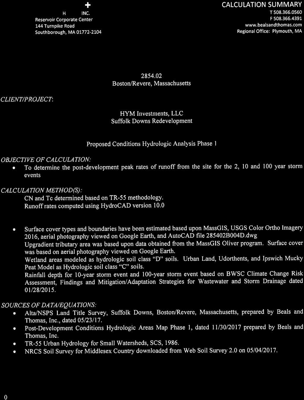
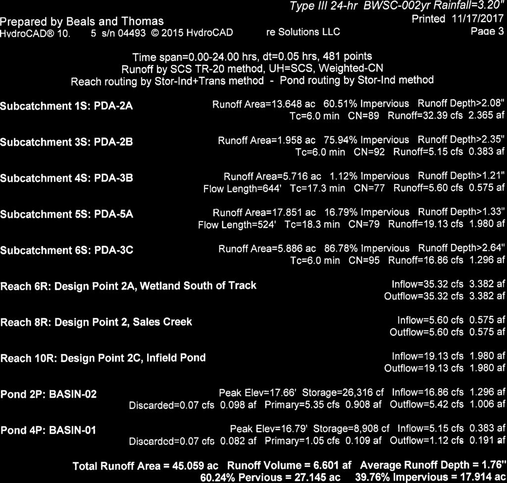
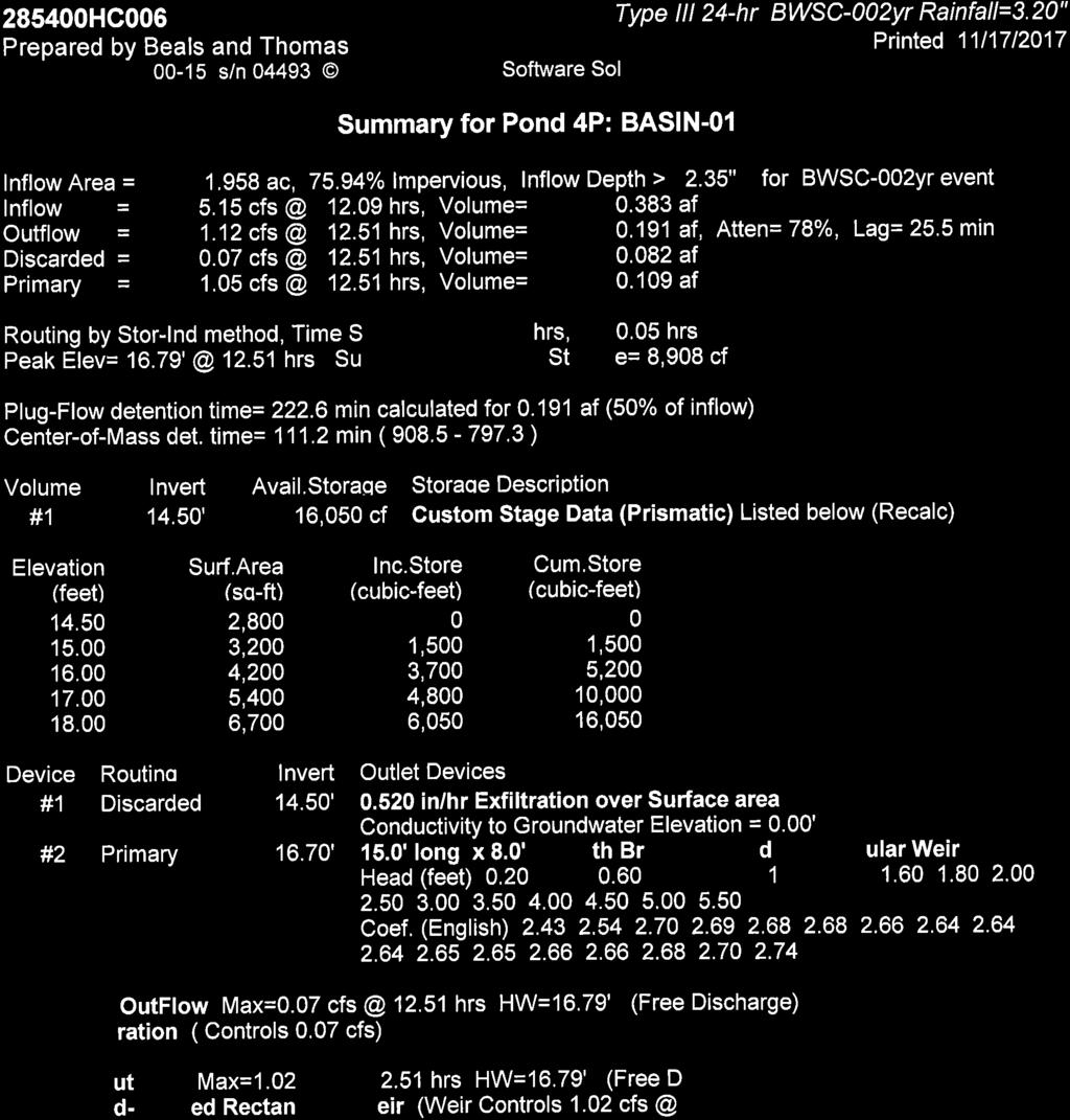
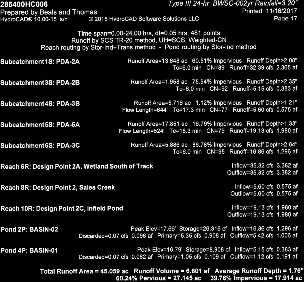
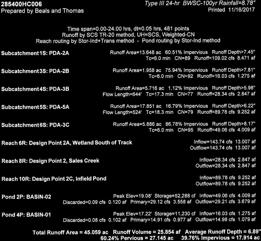
4 Suffolk Downs Redevelopment Phase 1 Stormwater Management Report Boston, Massachusetts RP INTRODUCTION The proposed Phase 1 Project includes a stormwater management system designed to mitigate potential impacts to the existing watershed from the proposed project. Stormwater management measures are proposed to control peak runoff rates, provide water quality treatment, promote groundwater recharge, and promote sediment removal. The stormwater management system has been designed to comply with: The 2008 Massachusetts Department of Environmental Protection (MassDEP) Stormwater Management Handbook, The Massachusetts Wetland Protection Act Regulations (310 CMR 10.00), The Boston Water and Sewer Commission Stormwater Requirements; The Phase 1 Project Site currently discharges to Land Subject to Coastal Storm Flowage (LSCSF) and ultimately to the Atlantic Ocean. The MassDEP Stormwater Management Handbook waives the requirement to mitigate peak stormwater discharge rates for projects that discharge to LSCSF, however Sales Creek is isolated from tidal flows by the Bennington Street tide gates and Department of Conservation and Recreation (DCR) pumping station. To demonstrate that the Phase 1 Project will not increase stormwater flows to the pumping station, the pre- and post-development hydrologic conditions were modeled using HydroCAD TM software. The hydrologic model shows that post-development stormwater runoff rates will be less than or equal to the pre-development rates. To account for increased storm intensity projected to occur due to climate change, the 10-year and 100-year storm events used in the design of the proposed stormwater management system are based on the Boston Water and Sewer Commission s (BWSC) increased rainfall recommendations of 6.00 inches and 8.78 inches, respectively. The following table summarizes the peak runoff rates for the pre- and post-development conditions. Design Point 2 Design Point 2A Design Point 2C 2 Year 10 Year 100 Year Pre Post Pre Post Pre Post Note: A design change has increased impervious area to Design Point 2C by approximately 0.50 acres to enable the existing on-site access drive parallel to Waldemar Avenue to loop into the proposed on-site drive. This change is not anticipated to have a material impact on the drainage design and the calculations will be revised to reflect the final site plan. 2
5 Suffolk Downs Redevelopment Phase 1 Stormwater Management Report Boston, Massachusetts RP PRE-DEVELOPMENT CONDITIONS 2.1 Site Conditions Suffolk Downs was constructed in the early 1930s by filling marshlands and tidal creeks. At that time, the majority of the existing on-site stormwater management system was built and the portion of Sales Creek that passes through the Project Site was reconstructed as a drainage channel. This occurred prior to the promulgation of MassDEP Stormwater Management Standards; therefore the existing stormwater management infrastructure provides negligible stormwater quality treatment. The existing system primarily consists of catch basins, drain pipes, stormwater outfalls and conveyance channels. Drainage channels that surround the infield racetrack capture runoff from the racetrack and discharge it to the infield pond or Sales Creek. Improvements have been made to the system over time. Between 2003 and 2005 in conjunction with the development of the shopping plaza to the west, the drainage system from Tomasello Road and select parking lots on the Project Site were redirected to the stormwater basin located off-site to the west of the Project Site. In 2012 further improvements were made to treat runoff from the barn and stable areas, which are classified as a Concentrated Animal Feeding Operation (CAFO) pursuant to the Clean Water Act. These improvements ensure that pollutants from the CAFO do not enter Sales Creek. The work included: conveying all stormwater runoff from the CAFO to a process water holding pond, where it is then pumped to the BWSC sanitary sewer system during dry weather, installing four sand filters to treat the runoff from the racetrack, installing a dedicated roof runoff collection system for the stable barns, and installing infiltration islands. The Phase 1 Project Site drains to two primary locations on-site. The track area and infield drain to the pond located within the infield. The race track and infield areas drain to the pond located within the infield (the infield pond ). The infield pond is approximately a 1-acre human-made feature constructed for ornamental purposes prior to A number of drainage channels direct runoff from the track to the pond. The level of the pond is regulated by a water control structure at the northern edge of the pond which artificially controls the mean annual flood level of the pond. Overflow from the pond drains to Sales Creek via an 18-inch culvert. The existing overflow parking area and area outside of the track drain to the intermittent stream located along the eastern perimeter of the Project Site (H-series flags). the intermittent stream also drains to Sales Creek. Sales Creek discharges to Belle Isle Marsh and ultimately Boston Harbor. Sales Creek is isolated from tidal flows by the Bennington Street tide gates and a stormwater pumping station that is owned and operated by the Department of Conservation and Recreation (DCR). During lower tides, Sales Creek flows directly via gravity to Belle Isle Inlet via 3
6 Suffolk Downs Redevelopment Phase 1 Stormwater Management Report Boston, Massachusetts RP004 culverts under Bennington Street. During higher tides, when the tide gates are closed, flow in Sales Creek may be pumped to Belle Isle Inlet by the Bennington Street stormwater pumping station to mitigate high water levels in Sales Creek Critical Areas Critical Areas as defined by Standard 6 of the 2008 MassDEP Stormwater Management Handbook are areas where high levels of stormwater treatment is required; typically the first inch of runoff is treated using specific best management practices (BMPs) and pre-treatment methods. Specific source control and pollution prevention measures are also required. The Massachusetts Surface Water Quality Standards (314 CMR 4.00) list both Sales Creek and the H-series intermittent stream as Class SA Outstanding Resource Waters (ORW). Pursuant to the Surface Water Quality Standards, these waters are designated as an excellent habitat for fish, other aquatic life, and wildlife and shall have an excellent aesthetic value. Belle Isle Marsh consists of approximately 241-acres and is part of the larger Rumney Marsh Area of Critical Environmental Concern (ACEC). Belle Isle Marsh is designated as a shellfish growing area by the Division of Marine Fisheries but is currently listed as an area where shellfish growing is prohibited. Both ORWs and shellfish growing areas are classified as critical areas Total Maximum Daily Loads MassDEP has issued a draft Pathogen Total Maximum Daily Load (TMDL) for the Boston Harbor Watershed (excluding the Neponset River sub-basin). A TMDL is the greatest amount of a pollutant that a waterbody can accept and still meet water quality standards for protecting public health and maintaining the designated beneficial uses of those waters for drinking, swimming, recreation, and fishing. A TMDL is implemented by specifying how much of that pollutant can come from point, nonpoint, and natural sources. Urban runoff, combined sewer overflows, sewer overflows and heavy industrial activity have impaired Boston Harbor. Known pollutants include, but are not limited to, fecal coliform, e. coli, phosphorus, and total suspended solids. 4
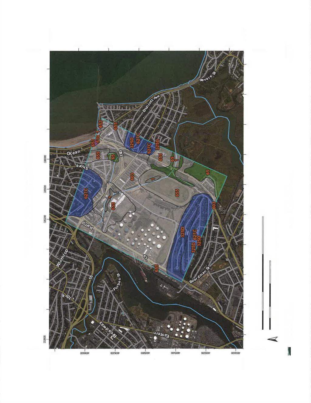
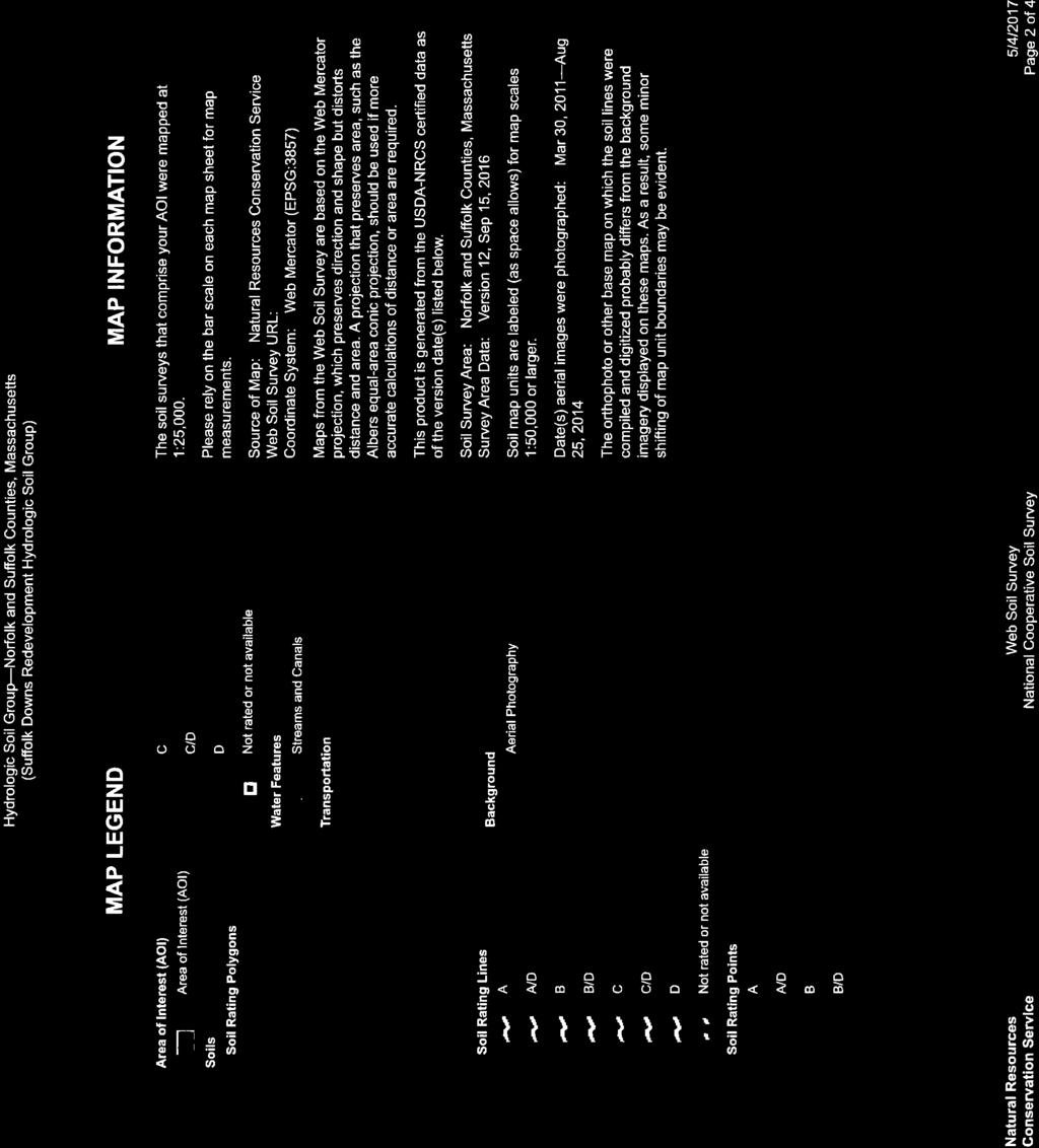
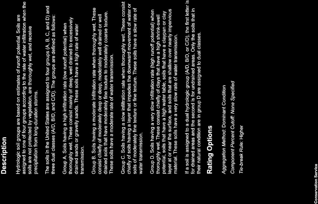
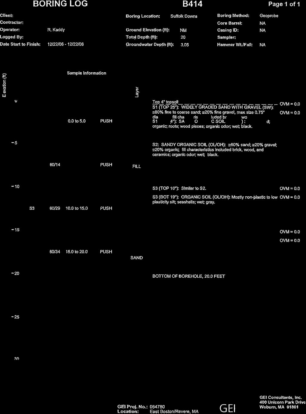
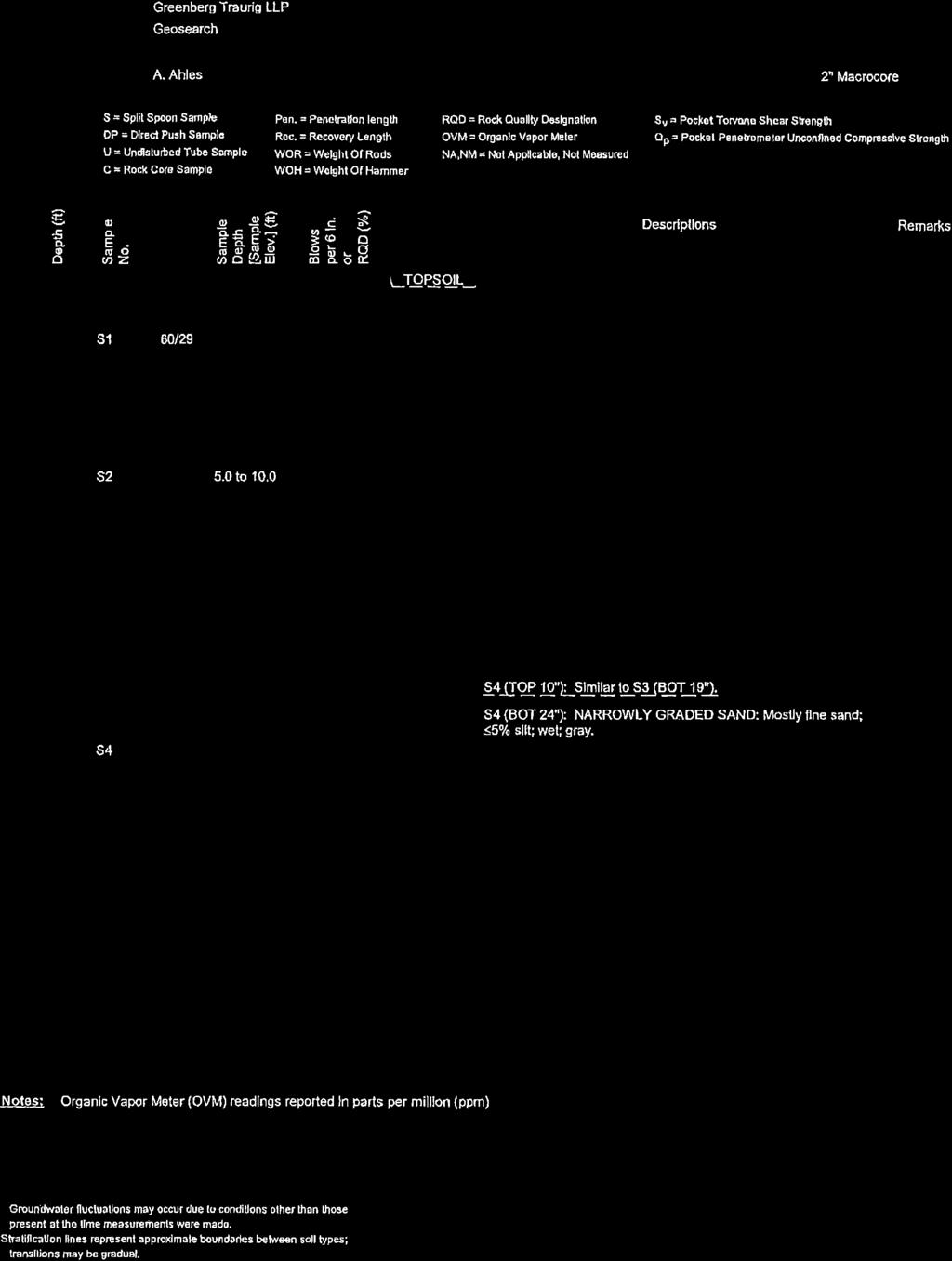
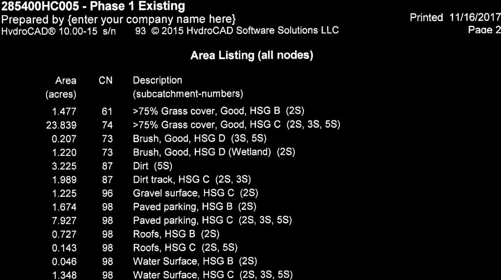
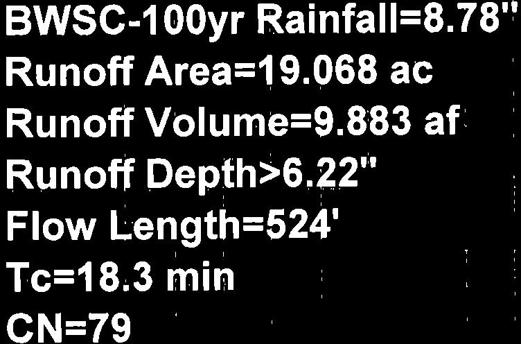
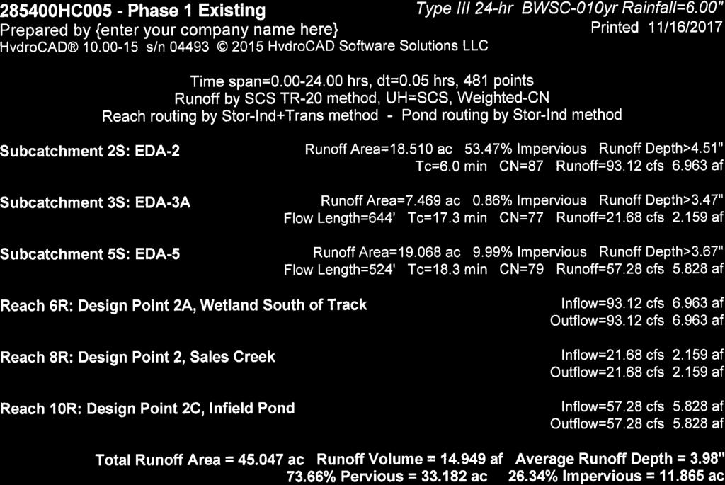
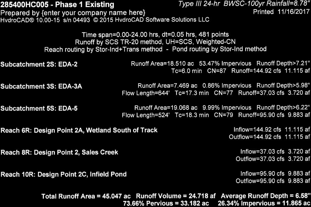
7 Suffolk Downs Redevelopment Phase 1 Stormwater Management Report Boston, Massachusetts RP Soil Description The Natural Resources Conservation Service (NRCS) Web Soil Survey indicates that the soils within the racetrack consist of Udorthents with wet substratum. These soils are located in areas that were previously tidal marshes, river floodplains, bays, harbors, and swamps. The fill consists of rubble, refuse, and mixed soil material, typically, sand, gravel, and channel dredgings. The parking area are listed as Urban land with wet substratum. These soils consist of developed areas within Udorthents, wet substratum. No hydrologic soil class is assigned to these soil types, but permeability is typically low. Small areas of Newport silt loam line the southern boundary of the Phase 1 Project Site. This is a deep, well-drained soil with moderate permeability, and typically shallow groundwater. It is classified as hydrologic soil class B. The soils along the eastern boundary of the Phase 1 Project Site consist of Ipswich mucky peat, which is a very poorly drained, nearly level soil in tidal marshes. It is listed as hydrologic soil class A/D. Test pits performed on the Project Site in 2012 by Haley and Aldrich, Inc., indicated consistent material generally throughout the Project Site, consisting of fill. The top 24- inches of soil are classified as either poorly graded sand or silty sand. Below 24-inches the soil is mostly unclassified fill, poorly graded sand, silty sand, or clayey sand. Groundwater was found on average 2 to 7-feet below existing grade. 2.3 Hydrologic Analysis Sub-catchment areas were delineated based on existing runoff patterns and topographic information. This information is shown on the Pre-Development Conditions Hydrologic Areas Map included in Appendix B. Summaries of each area with respect to Curve Number and Time of Concentration calculations can be found in the model results also in Appendix B. To account for the increased storm intensity projected to occur due to climate change rainfall depths used in the hydrologic model were based on a presentation entitled BWSC Climate Change Risk Assessment, Findings and Mitigation/Adaptation Strategies for Wastewater and Storm Drainage, dated January 28, 2015 and prepared by Boston Water and Sewer Commission. The 10-year and 100-year storm events were modeled with a total depth of 6.00 inches and 8.78 inches, respectively. 5
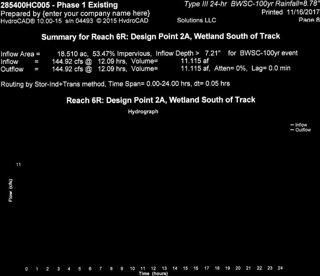
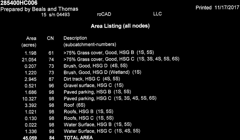
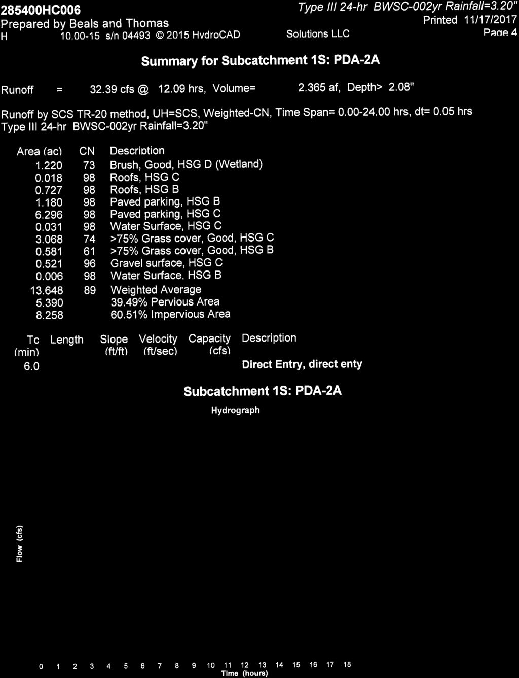
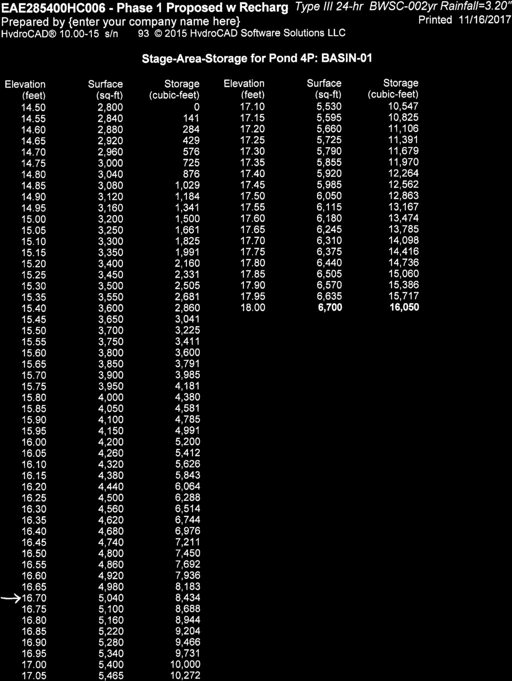
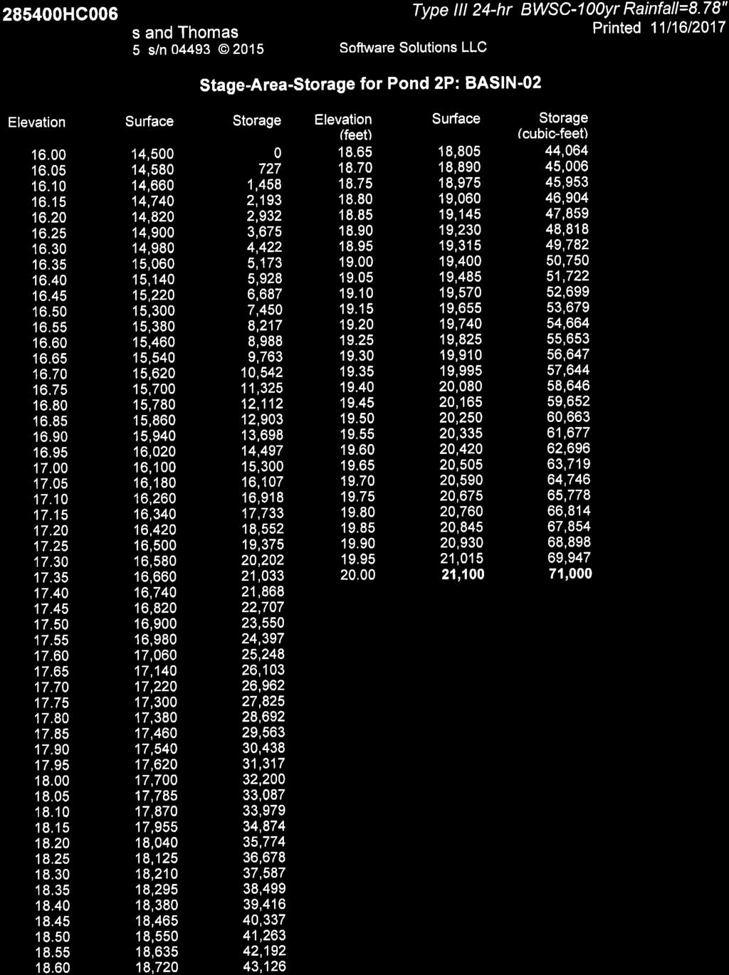
8 Suffolk Downs Redevelopment Phase 1 Stormwater Management Report Boston, Massachusetts RP POST-DEVELOPMENT CONDITIONS 3.1 Design Strategy During the design phase of the site layout, consideration was given to conserving environmentally sensitive features and minimizing impact on the existing hydrology. On-site resource areas, such as those associated with the intermittent stream and infield pond, will not be altered by the proposed project. A stormwater management system has been designed to provide treatment for stormwater runoff associated with the proposed impervious surfaces on site. All stormwater BMPs were designed to treat a minimum of the first 1.0 inch of runoff generated by the on-site impervious areas. Proprietary stormwater treatment systems were designed to treat the runoff rate associated with the water quality volume in accordance with the requirements of the MassDEP Stormwater Handbook. To mitigate increased stormwater flow rates associated with the proposed impervious area, two infiltration basins have been proposed. The bottom of infiltration basin 1 has been set at elevation Based on soil borings within this area groundwater is assumed to be at elevation 12.0 approximately. The bottom of infiltration basin 2 is set at elevation Groundwater is assumed to be at elevation 10.0 is this area. Both infiltration basins were sized using the Simply Dynamic Method, as described in Chapter 3 of the Massachusetts Stormwater Handbook. The system has been designed to meet the required recharge volume, and will fully dewater within 72 hours. 3.2 Hydrologic Analysis The established design points used in the pre-development conditions analysis were used in the post-development analysis for direct comparison. The tributary areas and flow paths were modified to reflect post-development conditions. See Appendix C for the Post- Development Conditions Hydrologic Areas Map. Summaries of each area with respect to Curve Number and Time of Concentration calculations can be found in the model results in Appendix C. 6
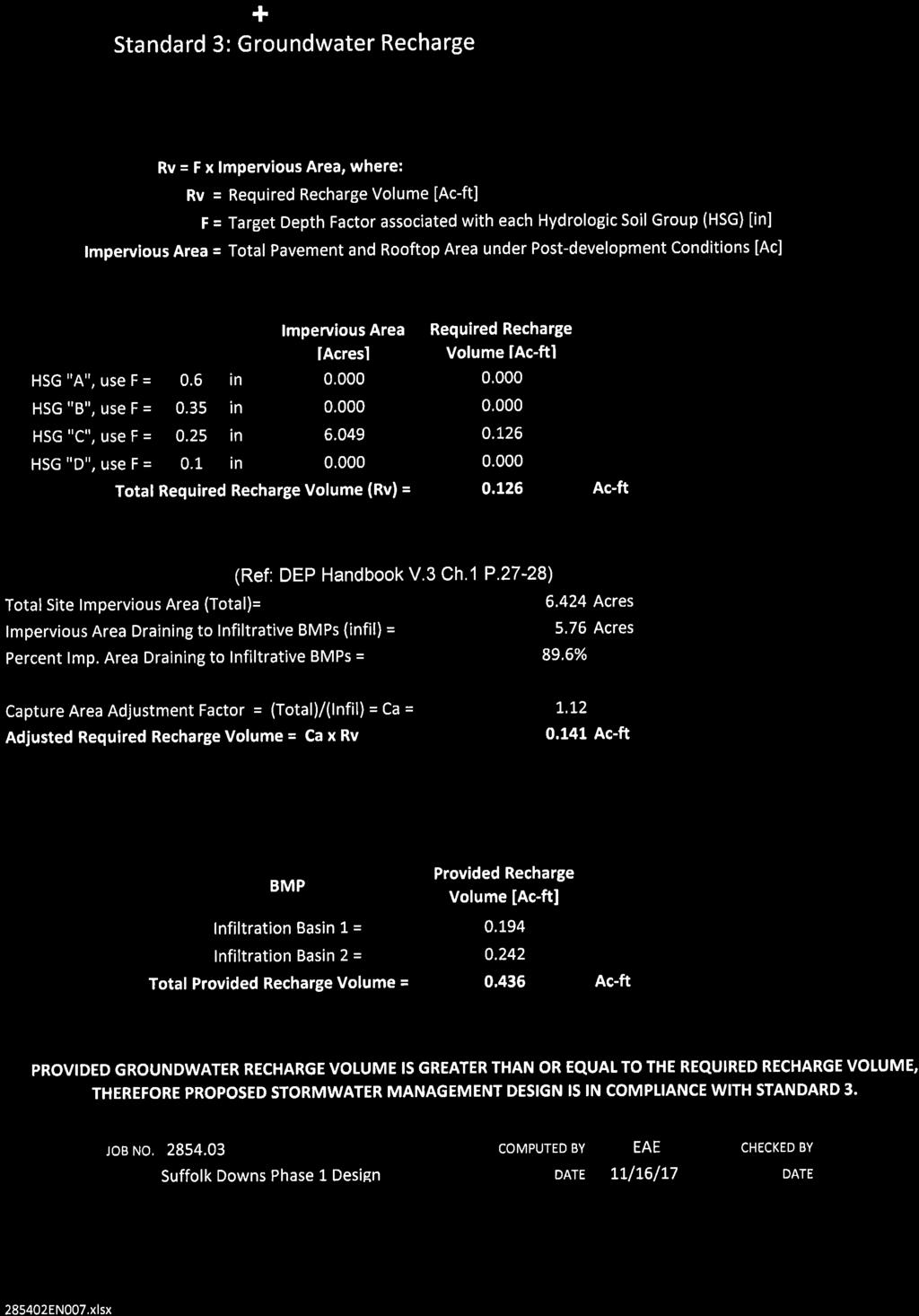
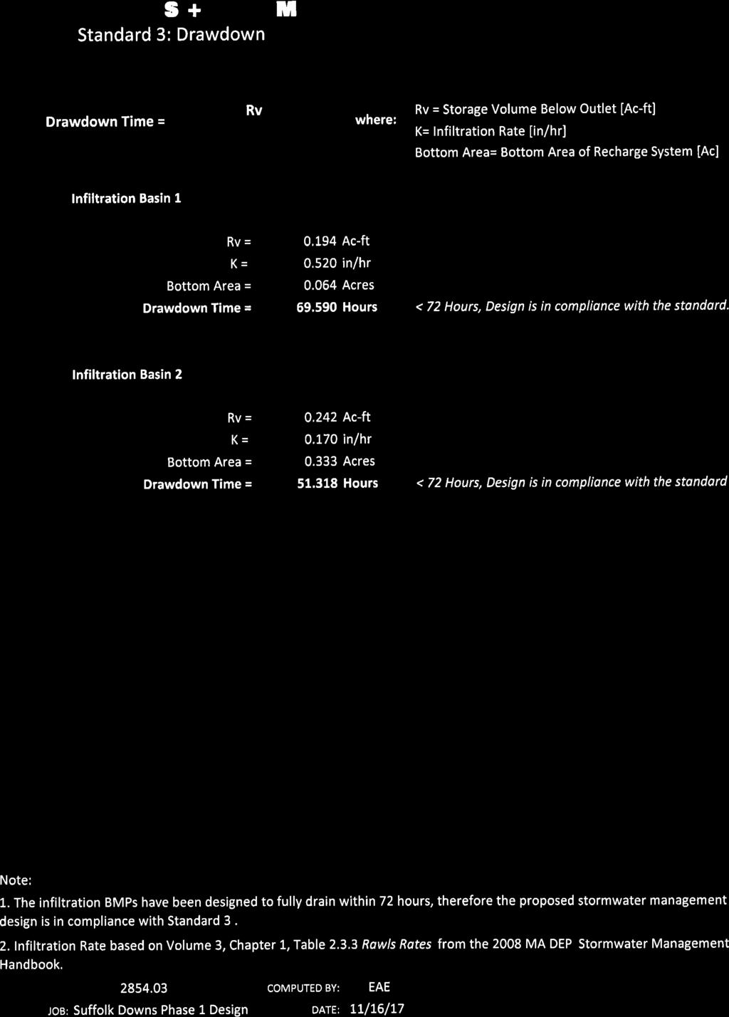
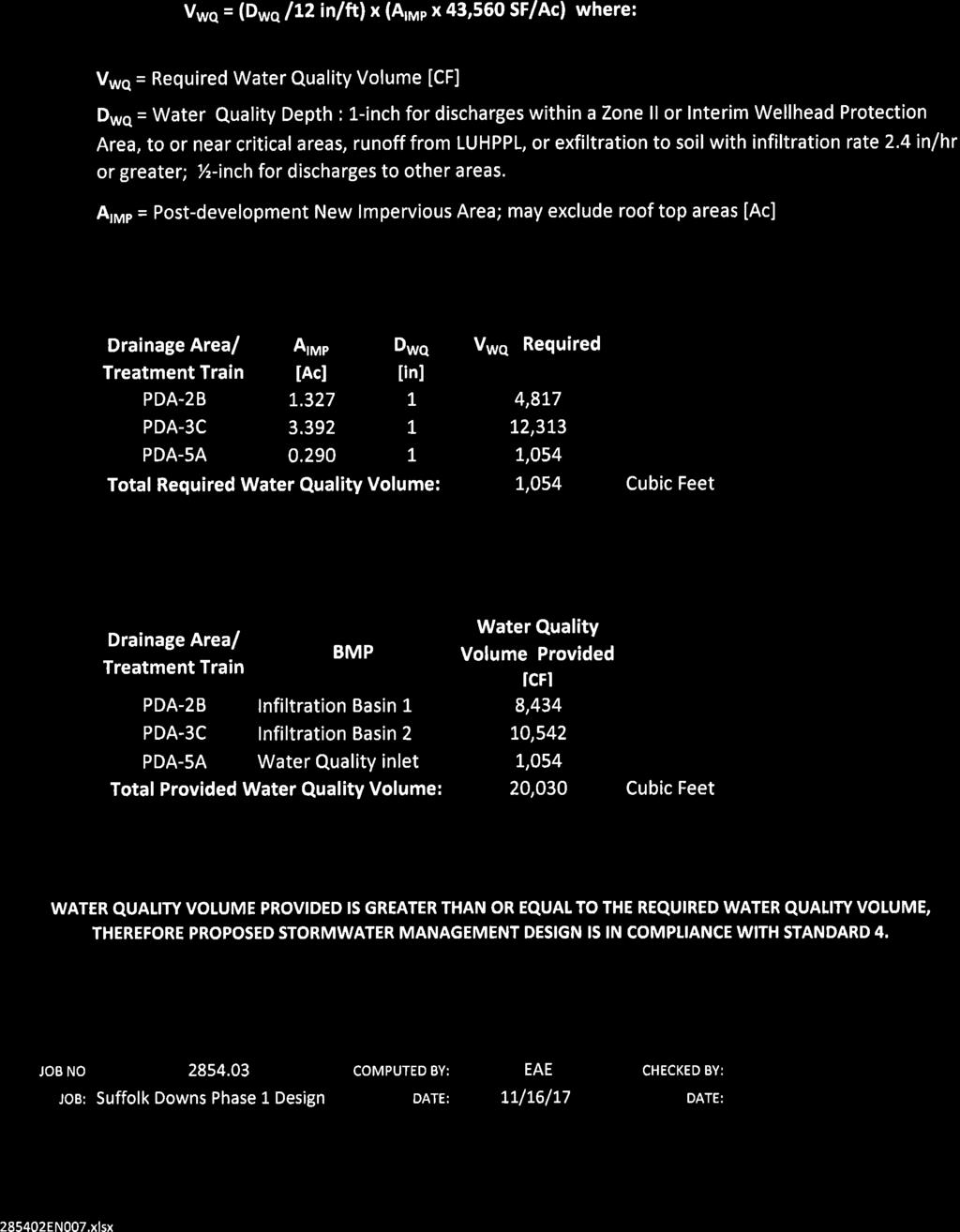
9 Suffolk Downs Redevelopment Phase 1 Stormwater Management Report Boston, Massachusetts RP Compliance with MassDEP Stormwater Management Standards The proposed stormwater management system was designed in compliance with the ten (10) DEP Stormwater Management Standards. The following summary provides key information related to the proposed stormwater management system, its design elements, and mitigation measures for potential impacts. STANDARD 1: No new stormwater conveyance (e.g. outfalls) may discharge untreated stormwater directly to or cause erosion in wetlands or waters of the Commonwealth. There will be no direct discharge of untreated stormwater to nearby wetlands or waters of the Commonwealth. Runoff from all impervious areas of the Phase 1 Project Site will be conveyed to stormwater management controls for water quality treatment and runoff rate attenuation prior to discharge to adjacent streams and wetlands. STANDARD 2: Stormwater management systems shall be designed so that postdevelopment peak discharge rates do not exceed pre-development peak discharge rates. As previously discussed, the Phase 1 Project will control post-development peak discharge rates for the 2-, 10-, and 100-year, 24-hour storms so as to maintain predevelopment peak discharge rates. STANDARD 3: Loss of annual recharge to groundwater shall be eliminated or minimized through the use of environmentally sensitive site design, low impact development techniques, stormwater management practices and good operation and maintenance. At a minimum, the annual recharge from the post-development site shall approximate the annual recharge from pre-development conditions based on soil types. This Standard is met when the stormwater management system is designed to infiltrate the required recharge volume as determined in accordance with the Massachusetts Stormwater Handbook. The stormwater management system includes two infiltration basins that will effectively recharge groundwater on-site. Infiltration BMPs were sized using the simple dynamic method based on the required recharge volume for the post-development site. As a result, annual 7
10 Suffolk Downs Redevelopment Phase 1 Stormwater Management Report Boston, Massachusetts RP004 recharge from the post-development site will approximate the annual recharge from the site under pre-development conditions. See Appendix D for stormwater BMP design worksheets and Groundwater Recharge Calculation. STANDARD 4: Stormwater management systems shall be designed to remove 80% of the average annual post-construction load of Total Suspended Solids (TSS). The proposed Phase 1 Project will be designed to meet the water quality requirements of Standard 4 using on-site treatment trains that achieve 80% TSS removal. Structural BMPs designed for water quality treatment, including deep sump hooded catch basins, water quality treatment systems, and infiltration basins will be sized to capture and treat the flow rate associated with the first 1.0-inch of runoff from the proposed impervious surfaces. All proposed stormwater management BMPs will be operated and maintained to ensure continued water quality treatment of runoff. A Site Owner s Manual that complies with the Long-Term Pollution Prevention Plan (Standard 4) and the Long-Term Operation and Maintenance Plan (Standard 9) requirements of the 2008 MassDEP Stormwater Management Standards will be developed. The Manual will outline the source control and pollution prevention measures and maintenance requirements of the stormwater BMPs associated with the proposed development. STANDARD 5: For land uses with higher potential pollutant loads (LUHPPLs), source control and pollution prevention shall be implemented in accordance with the Massachusetts Stormwater Handbook to eliminate or reduce the discharge of stormwater runoff from such land uses to the maximum extent practicable. The Phase 1 Project includes a parking lot with high intensity use. The primary parking for the Project will be located within the building. Runoff from the interior spaces will be collected by and oil water separator designed in accordance with the plumbing code prior to discharging to the sewer system. STANDARD 6: Stormwater discharges to critical areas must utilize certain stormwater management BMPs approved for critical areas. Critical areas are Outstanding Resource Waters, shellfish beds, swimming beaches, coldwater fisheries and recharge areas for public water supplies. The proposed BMPs will be consistent with the MassDEP Stormwater Management Handbook for discharges within critical areas. The stormwater management system will be designed to capture and treat the first 1.0-inch of runoff as stipulated in the MassDEP Stormwater 8
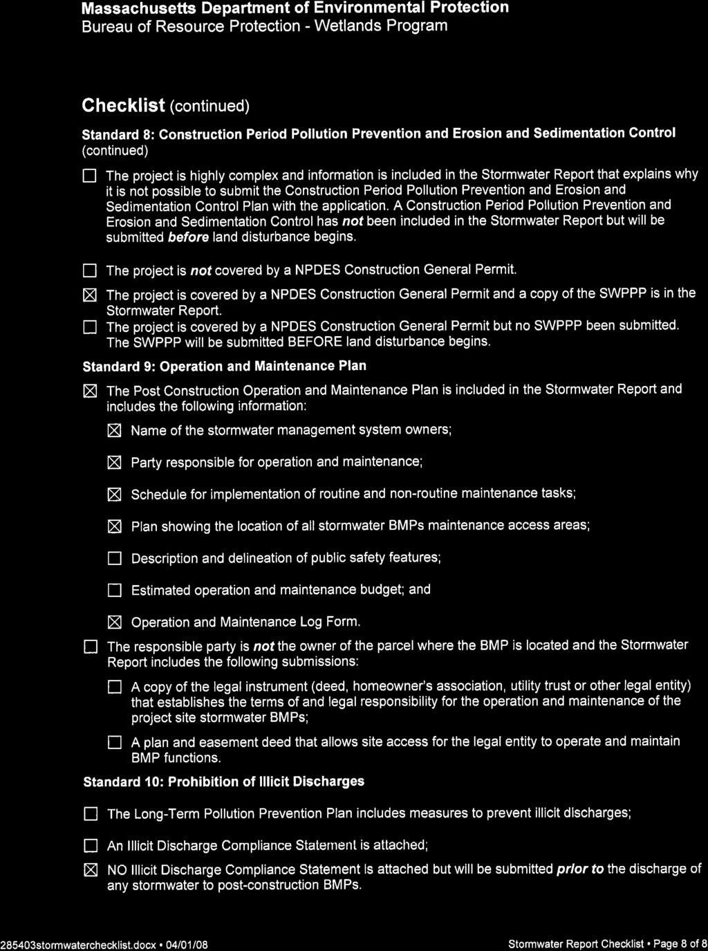
11 Suffolk Downs Redevelopment Phase 1 Stormwater Management Report Boston, Massachusetts RP004 Management Handbook. Deep sump hooded catch basins and water quality treatment systems are proposed to remove pollutants from the first 1.0-inch of runoff from all new impervious areas. Adequate pretreatment will be provided before discharge. STANDARD 7: Redevelopment of previously developed sites must meet the Stormwater Management Standards to the maximum extent practicable. However, if it is not practicable to meet all the Standards, new (retrofitted or expanded) stormwater management systems must be designed to improve existing conditions. The Project is a mix of new development and redevelopment. All new impervious areas will be designed to fully comply with all standards of the Stormwater Management Handbook. STANDARD 8: A plan to control construction-related impacts during erosion, sedimentation and other pollutant sources during construction and land disturbance activities (construction period erosion, sedimentation, and pollution prevention plan) shall be developed and implemented. A Stormwater Pollution Prevention Plan (SWPPP) will be developed to comply with Section 3 of the NPDES Construction General Permit for Stormwater Discharges; therefore the requirements of Standard 8 will be fulfilled. STANDARD 9: A Long-Term Operation and Maintenance (O&M) Plan shall be developed and implemented to ensure that stormwater management systems function as designed. The Site Owner s Manual complies with the Long-Term Pollution Prevention Plan (Standard 4) and the Long-Term Operation and Maintenance Plan (Standard 9) requirements of the 2008 Massachusetts Department of Environmental Protection (MassDEP) Stormwater Management Standards. The Manual outlines source control and pollution prevention measures and maintenance requirements of the stormwater best management practices (BMPs) associated with the proposed development. STANDARD 10: All illicit discharges to the stormwater management system are prohibited. There will be no illicit discharges to the proposed stormwater management system associated with the proposed Phase 1 Project. An Illicit Discharge Compliance Statement will be provided 9
12 Suffolk Downs Redevelopment Phase 1 Stormwater Management Report Boston, Massachusetts RP004 in the final Stormwater Report included in the required Notice of Intent Application to the City of Boston Conservation Commission. 10
13
14
15
16
17
18
19
20
21
22
23
24
25
26
27
28

29
30

31
32

33
34
35
36
37
38
39
40
41
42
43
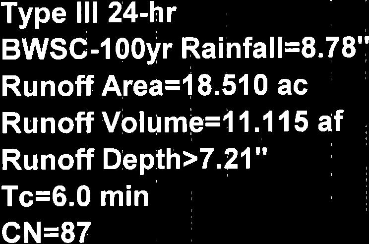
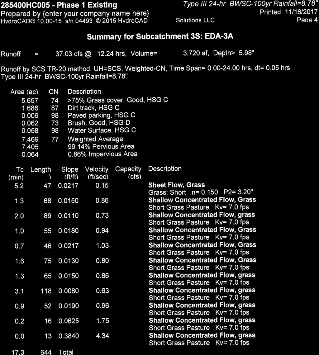
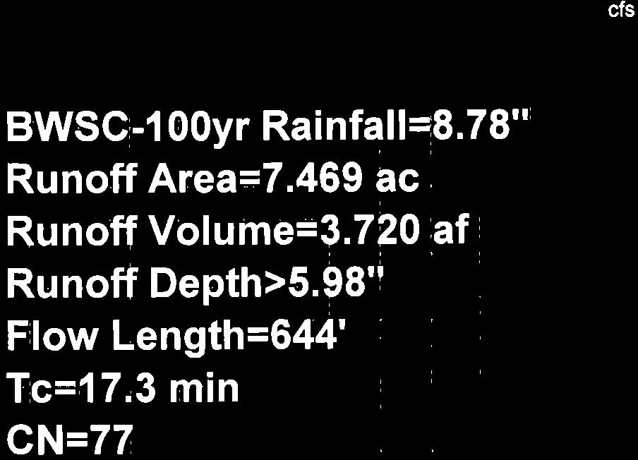
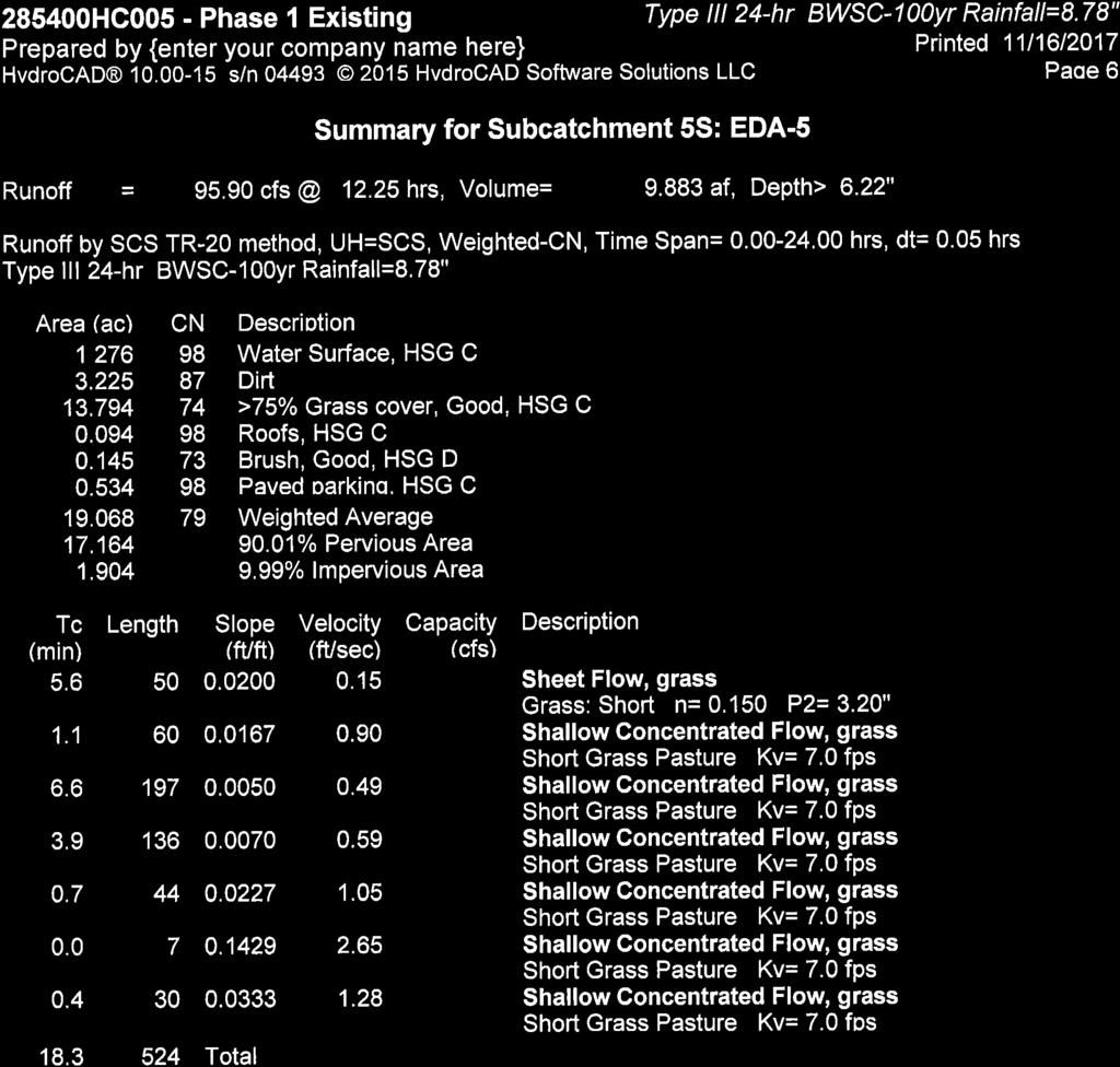
44 Suffolk Downs Boston, Massachusetts EDA-2 EDA-5 EDA-3A DESIGN POINT 2C DESIGN POINT 2A DESIGN POINT 2 B E A L S + T H O M A S Civil Engineers + Landscape Architects + Land Surveyors + Planners + Environmental Specialists B+T Drawing No P049A-001 Date: 11/30/2017 Scale: 1" = 100' Pre-Development Conditions Hydrology Map Phase 1
45
46
47
48
49
50
51
52

53

54
55
56
57
58
59
60
61
62
63

64
65

66
67
68 Suffolk Downs Boston, Massachusetts PDA-2A DESIGN POINT 2C PDA-5A PDA-3B PDA-5A PDA-3C PDA-2B BASIN-01 BASIN-02 DESIGN POINT 2A PDA-2A DESIGN POINT 2 B E A L S + T H O M A S Civil Engineers + Landscape Architects + Land Surveyors + Planners + Environmental Specialists B+T Drawing No P049A-002 Date: 11/30/2017 Scale: 1" = 100' Post-Development Conditions Hydrology Map Phase 1
69

70
71
72
73
74

75

76
77
78
79
80
81

82
83
84
85
86
87
88
89
90
91
92
93
94
95
96
97
98
99
100
101
102
103

104
105
106
107
108
109


110
111
112
113
114
115
116
117
118
119
120
121
122
123

124
125
126
127
128
129
130
131
132
133
134
135

136
137
138
139
140
141
142
143
144
145
146
147
148
149
150
151
152
153
154
155
156
157
158
159
160
161
162
163
164
165
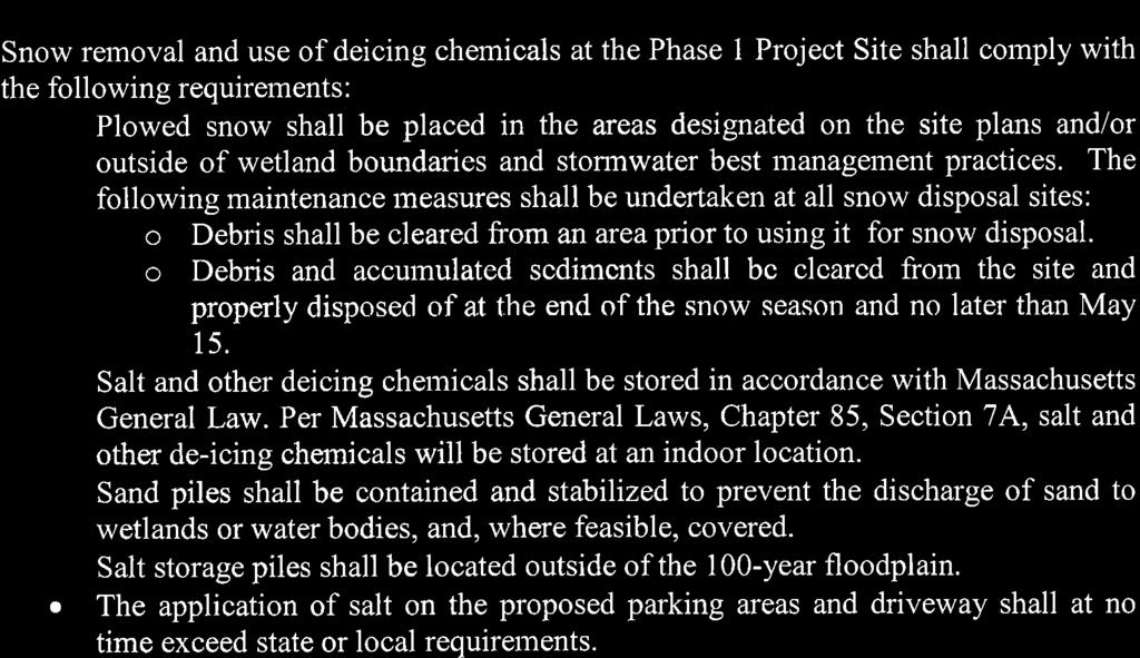
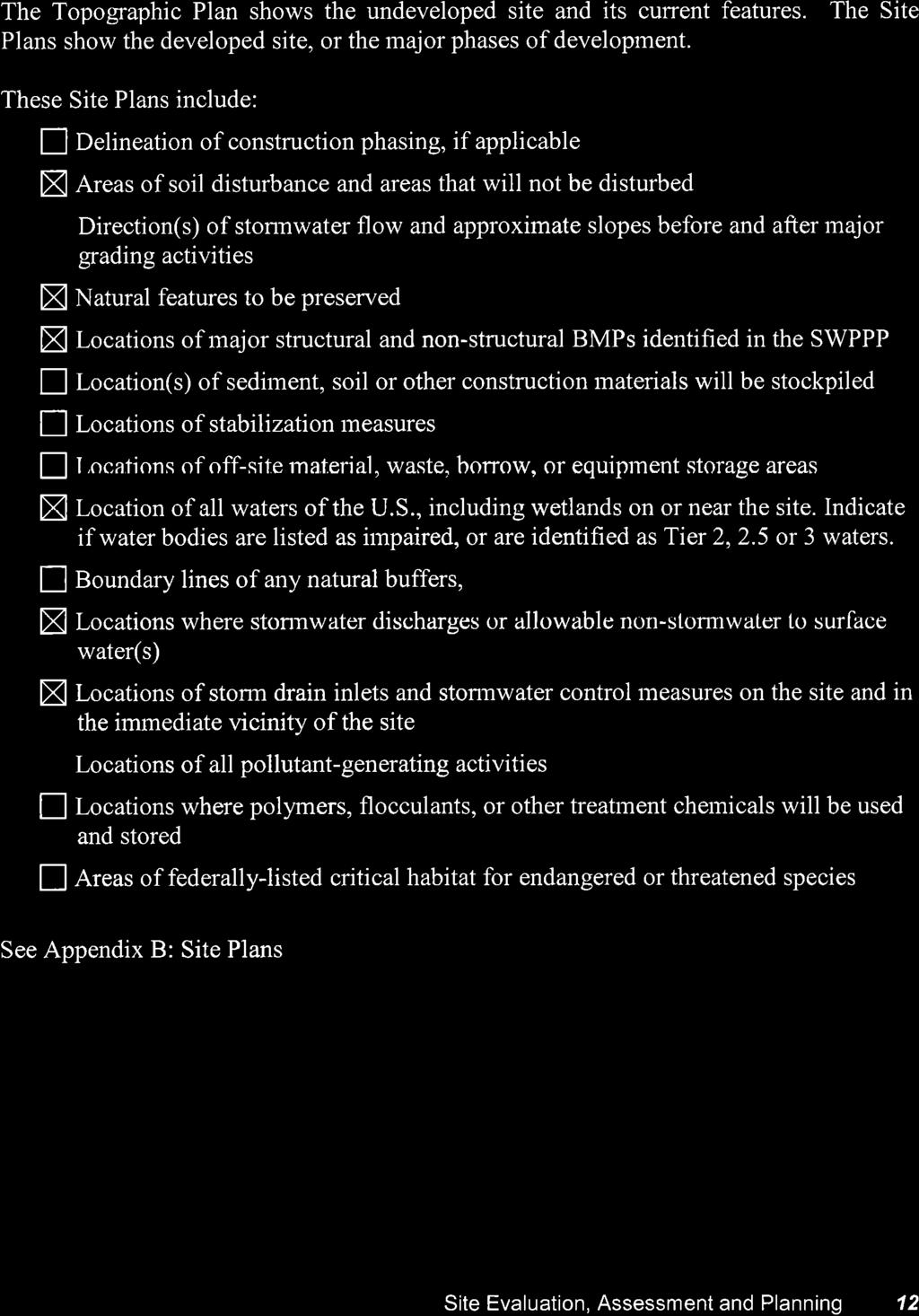
Stormwater Management Standards
 Stormwater Management Standards In 1996, the Massachusetts Department of Environmental Protection (the Department or MassDEP ) issued the Stormwater Policy that established Stormwater Management Standards
APPENDIX H Guidance for Preparing/Reviewing CEQA Initial Studies and Environmental Impact Reports
 APPENDIX H H.1 Guidance for Preparing and Reviewing CEQA Initial Studies Step 1: Consider the Project Characteristics as Provided by the Project Applicant Review the project application and draft plan
E. STORMWATER MANAGEMENT
 E. STORMWATER MANAGEMENT 1. Existing Conditions The Project Site is located within the Lower Hudson Watershed. According to the New York State Department of Environmental Conservation (NYSDEC), Lower Hudson
Municipal Stormwater Management Planning
 Municipal Stormwater Management Planning Christopher C. Obropta, Ph.D., P.E. Water Resources Extension Specialist with Rutgers Cooperative Extension Assistant Professor with Department of Environmental
S.O.P. No. HMD
 Page: 1 of 9 PURPOSE: To establish (SOP) for submission requirements, review process and approval of applications for Non-vehicular Access Permits for the purpose of connection or discharge to any MassDOT
ALMY POND TMDL MANAGEMENT PLAN
 ALMY POND TMDL MANAGEMENT PLAN PUBLIC WORKSHOP Presented by: City of Newport Department of Utilities And Pare Corporation May 7, 2014 Presentation Overview Introduction to Almy Pond Project Introduction
CHESAPEAKE BAY TMDL ACTION PLAN ( MS4 General Permit)
") CHESAPEAKE BAY TMDL ACTION PLAN (2013 2018 MS4 General Permit) Central Virginia Community College A Plan for Achieving a 5% Reduction of Existing Loads June 30, 2015 Main Campus This plan satisfies the
CHESAPEAKE BAY TMDL ACTION PLAN (2013 2018 MS4 General Permit) Central Virginia Community College A Plan for Achieving a 5% Reduction of Existing Loads June 30, 2015 Main Campus This plan satisfies the
Chapter 21 Stormwater Management Bylaw
 Chapter 21 Stormwater Management Bylaw SECTION 1. PURPOSE The purpose of this Bylaw is to: implement the requirements of the National Pollutant Discharge Elimination System (NPDES) General Permit for Storm
UNIVERSITY OF OREGON NORTH CAMPUS CONDITIONAL USE PERMIT PROJECT Draft Conditional Use Permit Stormwater, Sanitary Sewer, and Water Analysis Report
 UNIVERSITY OF OREGON NORTH CAMPUS CONDITIONAL USE PERMIT PROJECT Draft Conditional Use Permit Stormwater, Sanitary Sewer, and Water Analysis Report Prepared for: Cameron McCarthy Landscape Architects LLP
CHESAPEAKE BAY TMDL ACTION PLAN ( MS4 General Permit)
") CHESAPEAKE BAY TMDL ACTION PLAN (2013 2018 MS4 General Permit) Piedmont Virginia Community College A Plan for Achieving a 5% Reduction of Existing Loads June 30, 2015 Main Campus This plan satisfies the
CHESAPEAKE BAY TMDL ACTION PLAN (2013 2018 MS4 General Permit) Piedmont Virginia Community College A Plan for Achieving a 5% Reduction of Existing Loads June 30, 2015 Main Campus This plan satisfies the
New Castle County, DE. Floodplain Regulations
 New Castle County, DE Floodplain Regulations John J. Gysling, PE CFM Department of Land Use New Castle County, DE February 26, 2009 Today s Presentation Floodplain Protection and Uses Terms and Definitions
Regulatory Requirements
 CHAPTER 1 Regulatory Requirements 1.0 Introduction The negative impacts of unmanaged stormwater runoff present a challenge to the City of Philadelphia, including increased runoff pollutant concentrations,
16.0 Water Quality Management Criteria for Developed Land
 October 2003, Revised February 2005 Criteria for Developed Land Page 1 16.1 Introduction 16.0 Water Quality Management Criteria for Developed Land Stormwater quality control is an integral part of any
STREAM AND BUFFER AREA PROTECTION/RESTORATION
 STREAM AND BUFFER AREA PROTECTION/RESTORATION AMENDMENT OPTIONS TO STRENGTHEN POLICY IN HEADWATERS AREAS DRAFT SUBSEQUENT TO THE JANUARY 25, 2007 MEETING OF THE PLANNING COMMISSION ENVIRONMENT COMMITTEE
Pennsylvania Stormwater Best Management Practices Manual. Chapter 3. Stormwater Management Principles and Recommended Control Guidelines
 Pennsylvania Stormwater Best Management Practices Manual Chapter 3 Stormwater Management Principles and Recommended Control Guidelines 363-0300-002 / December 30, 2006 Chapter 3 Stormwater Management Principles
COON CREEK WATERSHED DISTRICT PERMIT REVIEW. Spring Lake Park Schools Westwood Middle School st Avenue NE, Spring Lake Park, MN 55432
 PAN 16-112, Westwood Middle School, Page 1 of 6 COON CREEK WATERSHED DISTRICT PERMIT REVIEW MEETING DATE: August 22, 2016 AGENDA NUMBER: 10 FILE NUMBER: 16-112 ITEM: Westwood Middle School RECOMMENDATION:
Preliminary Drainage Analysis
 Preliminary Drainage Analysis Tanimura and Antle Employee Housing Town of Spreckels County of Monterey, California LIB150205 May 29, 2015 Prepared For: Tanimura and Antle Produce Prepared By: 9699 Blue
Stormwater Local Design Manual For Houston County, Georgia
 Stormwater Local Design Manual For Houston County, Georgia Adopted November 15, 2005 TABLE OF CONTENTS 1. FORWARD... 1 2. GENERAL LEVEL OF SERVICE STANDARDS... 2 2.1. DETENTION REQUIREMENTS... 2 2.1.1.
BMP #: Infiltration Basin
 Structural BMP Criteria BMP #: Infiltration Basin An Infiltration Basin is a shallow impoundment that stores and infiltrates runoff over a level, subtle, uncompacted, (preferably undisturbed area) with
NEW CASTLE CONSERVATION DISTRICT. through. (Name of Municipality) PLAN REVIEW APPLICATION DRAINAGE, STORMWATER MANAGEMENT, EROSION & SEDIMENT CONTROL
 PLAN REVIEW APPLICATION DRAINAGE, STORMWATER MANAGEMENT, EROSION & SEDIMENT CONTROL") NEW CASTLE CONSERVATION DISTRICT through (Name of Municipality) PLAN REVIEW APPLICATION DRAINAGE, STORMWATER MANAGEMENT, EROSION & SEDIMENT CONTROL Office use only: Received by Municipality: Received by
NEW CASTLE CONSERVATION DISTRICT through (Name of Municipality) PLAN REVIEW APPLICATION DRAINAGE, STORMWATER MANAGEMENT, EROSION & SEDIMENT CONTROL Office use only: Received by Municipality: Received by
Municipal Stormwater Ordinances Summary Table
 APPENDIX F Municipal Ordinances Summary Table Municipality Abington Bryn Athyn Borough Hatboro Borough Ordinance, SALDO Runoff equals pre post Erosion Sediment Control Water Quality Requirements Any which
Storm Water Management Standards
 Storm Water Management Standards The City of Roseville has developed specific requirements that apply to development and redevelopment projects. These standards are intended to help achieve the water resource
UMD Storm Water Program Construction Requirements. Greg Archer, MBA Environmental Compliance Specialist
 UMD Storm Water Program Construction Requirements Greg Archer, MBA Environmental Compliance Specialist Phase 2 Regulatory Overview Dec. 1999 EPA issues Phase 2 Federal Register Municipalities (MS4) from
GUIDELINES FOR STORMWATER BACTERIA REDUCTIONS THROUGH BMP IMPLEMENTATION NY/NJ HARBOR TMDL DEVELOPMENT
 GUIDELINES FOR STORMWATER BACTERIA REDUCTIONS THROUGH BMP IMPLEMENTATION NY/NJ HARBOR TMDL DEVELOPMENT Elevated bacteria in stormwater runoff in urban areas are well documented by many researchers. Monitoring
MODEL Stormwater Local Design Manual. City of Centerville
 MODEL Stormwater Local Design Manual City of Centerville Adopted December 6, 2005 TABLE OF CONTENTS 1. FORWARD... 1 2. GENERAL LEVEL OF SERVICE STANDARDS... 1 2.1. DETENTION REQUIREMENTS... 1 2.1.1. Discharge
Standards for SWMF s. (Stormwater Management Facilities) Lacombe County s Guide to Developing Stormwater Management Facilities
 Lacombe County s Guide to Developing Stormwater Management Facilities") Standards for SWMF s (Stormwater Management Facilities) Lacombe County s Guide to Developing Stormwater Management Facilities August 2017 PREAMBLE Development results in a great amount of impervious area,
Standards for SWMF s (Stormwater Management Facilities) Lacombe County s Guide to Developing Stormwater Management Facilities August 2017 PREAMBLE Development results in a great amount of impervious area,
STORMWATER MANAGEMENT PROGRAM. Table of Contents
 STORMWATER MANAGEMENT PROGRAM Yakima Valley College March 1st, 0 1 0 1 Table of Contents INTRODUCTION... PROGRAM COMPONENTS... S.D.1: PUBLIC EDUCATION AND OUTREACH... Label Storm Drain Inlets:... Public
Notice of Project Change
 Commonwealth of Massachusetts Executive Office ofenergy and Environmental Affairs. MEPA Office Notice of Project Change For Office Use Only Executive Office of Environmental Affairs MEPAAnalyst: #olly
STORMWATER RUNOFF AND WATER QUALITY IMPACT REVIEW
 SUBCHAPTER 8 STORMWATER RUNOFF AND WATER QUALITY IMPACT REVIEW 7:45-8.1 Purpose and scope of review Except for those projects expressly exempted by this chapter or waived by the Commission, the Commission
SECTION 4 SURFACE WATER MANAGEMENT DESIGN AND CONSTRUCTION REQUIREMENTS
 SECTION 4 SURFACE WATER MANAGEMENT DESIGN AND CONSTRUCTION REQUIREMENTS Page 4-1 INTRODUCTION 4-3 4-1.01 Applicability of VMCs 14.24, 14.25, 14.26 4-4 4-1.02 Minimum Requirements - Projects Below Threshold
Chapter 1. Introduction
 Chapter 1 Introduction James P. Heaney, Robert Pitt, and Richard Field Introduction Stormwater has traditionally been considered a nuisance, requiring rapid and complete drainage from areas of habitation.
Water Resource Management Planning
 Water Resource Management Planning A Guide for Towns and Communities Massachusetts Department of Environmental Protection Bureau of Resource Protection 1 Winter Street Boston, MA 02108 About this Document
4.8. Subsurface Infiltration
 4.8. Subsurface Infiltration Subsurface infiltration systems are designed to provide temporary below grade storage infiltration of stormwater as it infiltrates into the ground. Dry wells, infiltration
Stormwater Management Fact Sheet: Porous Pavement
 Stormwater Management Fact Sheet: Porous Pavement Description Porous pavement is a permeable pavement surface with an underlying stone reservoir that temporarily stores surface runoff before infiltrating
Rhode Island Stormwater Design and Installations Standards Manual
 Rhode Island Stormwater Design and Installations Standards Manual Public Workshop Required Management Volume Calculations and Redevelopment Considerations March 22, 2011 Presentation Outline Recap of How
Project Name: Add a unique name that appropriately identifies the submission
 PTAPP Online Municipal Tracking Tool Instructions Project Name: Add a unique name that appropriately identifies the submission Municipal Project: Check this box if the project is part of municipal efforts
POLICY FOR NATURAL RESOURCE MANAGEMENT AREAS
 POLICY FOR NATURAL RESOURCE MANAGEMENT AREAS I. POLICY STATEMENT Auburn University's (the University's) "Policy for Natural Resource Management Areas" implements the Campus Master Plan Land Use Element
4.8. Subsurface Infiltration
 4.8. Subsurface Infiltration Subsurface infiltration systems are designed to provide temporary below grade storage infiltration of storm water as it infiltrates into the ground. Dry wells, infiltration
Factsheet: Town of Deep River Water Quality and Stormwater Summary
 79 Elm Street Hartford, CT 06106-5127 www.ct.gov/deep Affirmative Action/Equal Opportunity Employer Factsheet: Town of Deep River Water Quality and Stormwater Summary This document was created for each
Pennsylvania Stormwater Best Management Practices Manual
 Pennsylvania Stormwater Best Management Practices Manual Presented by the Pennsylvania Department of Environmental Protection Bureau of Watershed Protection In cooperation with: Cahill Associates Environmental
Review Zone Application for D&R Canal Commission Decision
 Review Zone Application for D&R Canal Commission Decision MEETING DATE: June 15, 2016 DRCC #: 15-4748 Phase I and II Latest Submission Received: May 4, 2016 Applicant: Kevin Hayes Country Club Meadows,
Understanding Stormwater Pollution Prevention Plans (SWPPPs) (SWPPPS)
 (SWPPPS)") Understanding Stormwater Pollution Prevention Plans (SWPPPs) (SWPPPS) Definitions SWPPP: Storm Water Pollution Prevention Plan BMP: Best Management Practice(s) to control pollution IDNR: Iowa Department
Understanding Stormwater Pollution Prevention Plans (SWPPPs) (SWPPPS) Definitions SWPPP: Storm Water Pollution Prevention Plan BMP: Best Management Practice(s) to control pollution IDNR: Iowa Department
Review of State and Federal Stormwater Regulations November 2007
 Review of State and Federal Stormwater Regulations November 2007 By: James T. Spaulding, PE, CPESC Joseph M. Ducharme, Jr., PE TTG ENVIRONMENTAL CONSULTANTS, LLC 27 LOCKE ROAD, CONCORD, NH 03301-5301 TELEPHONE:
The City of Cocoa (City) is located in east
 is located in east") FWRJ Reclaimed Water and Stormwater: A Perfect Pair to Meet Total Maximum Daily Load Wasteload Allocations? Danielle Honour, James Wittig, John A. Walsh, and Don Stevens Danielle Honour, P.E., D.WRE, and
FWRJ Reclaimed Water and Stormwater: A Perfect Pair to Meet Total Maximum Daily Load Wasteload Allocations? Danielle Honour, James Wittig, John A. Walsh, and Don Stevens Danielle Honour, P.E., D.WRE, and
CITY UTILITIES DESIGN STANDARDS MANUAL
 CITY UTILITIES DESIGN STANDARDS MANUAL () September 2017 Page Chapter 1 Acronyms and Definitions 1.01 Purpose 1 1.02 Acronyms 1 1.03 Definitions 3 Chapter 2 Introduction 2.01 Purpose 1 2.02 Applicability
EFFECT OF UPSTREAM DEVELOPMENT ON THE CLEAR CREEK AREA
 EFFECT OF UPSTREAM DEVELOPMENT ON THE CLEAR CREEK AREA Technical Memorandum Farming in the Floodplain Project Prepared for May 2017 PCC Farmland Trust Photo credit: Google Earth TABLE OF CONTENTS Page
BMP 6.4.4: Infiltration Trench
 BMP 6.4.4: Infiltration Trench An Infiltration Trench is a leaky pipe in a stone filled trench with a level bottom. An Infiltration Trench may be used as part of a larger storm sewer system, such as a
3.0 Planning and Submittal Requirements
 October 2003, Revised February 2005 Chapter 3.0, Planning and Submittal Requirements Page 1 3.0 Planning and Submittal Requirements 3.1 Drainage Studies and Drawings The City of Greenwood Village (Village)
Attachment 10: Updated Nitrogen TMDL Methodology
 Attachment 10: Updated Nitrogen TMDL Methodology Attachment 10 includes the updated Nitrogen TMDL Methodology to reflect the revised nitrogen loading rates from SELDM for various locations on Cape Cod,
Erosion & Sedimentation Control Policy
 Issue Date 10/22/2010 Page 1 of 8 Erosion & Sedimentation Control Policy Introduction: Soil erosion is the removal of soil by water, wind, ice or gravity and sediment deposition occurs when the rate of
Chapter 6. Hydrology. 6.0 Introduction. 6.1 Design Rainfall
 6.0 Introduction This chapter summarizes methodology for determining rainfall and runoff information for the design of stormwater management facilities in the City. The methodology is based on the procedures
(1)(A)Inventory of the following existing natural resources on the USFSP Campus or within the context area adjacent to the University.
(A)Inventory of the following existing natural resources on the USFSP Campus or within the context area adjacent to the University.") 13. 6C-21.208 CONSERVATION ELEMENT Information Sources George F. Young, Interview notes, June 2002 Sasaki Associates, Inc., interview notes, April, 2000 Interviews between DRMP Staff and USF Staff, May,
13. 6C-21.208 CONSERVATION ELEMENT Information Sources George F. Young, Interview notes, June 2002 Sasaki Associates, Inc., interview notes, April, 2000 Interviews between DRMP Staff and USF Staff, May,
[Rev - 1] 06/
![[Rev - 1] 06/](/thumbs/73/68893485.jpg "[Rev - 1] 06/") WVU DESIGN GUIDELINES & CONSTRUCTION STANDARDS DIVISION 33 UTILITIES SECTION 334100 STORMWATER MANAGEMENT PART 1 GENERAL 1.1. Any deviances from the following instructions must be approved during design
WVU DESIGN GUIDELINES & CONSTRUCTION STANDARDS DIVISION 33 UTILITIES SECTION 334100 STORMWATER MANAGEMENT PART 1 GENERAL 1.1. Any deviances from the following instructions must be approved during design
FOR PHASE I PROPERTIES
 FOR PHASE I PROPERTIES Updated March 2012 Port of Seattle Stormwater Management Program for Phase I Properties Table of Contents Introduction... 1 Port Overview... 1 Permit Overview... 2 Key Implementation
Stormwater Management Studies PDS Engineering Services Division ES Policy # 3-01
 Stormwater Management Studies PDS Engineering Services Division Revised Date: 2/28/08 INTRODUCTION The City of Overland Park requires submission of a stormwater management study as part of the development
SECTION STORM DRAINAGE DESIGN, GRADING, AND WATER QUALITY TECHNICAL CRITERIA TABLE OF CONTENTS PAGE 402 STORM DRAINAGE DESIGN CRITERIA 400-1
 CITY OF THORNTON Standards and Specifications Revised: October 2012 SECTION 400 - STORM DRAINAGE DESIGN, GRADING, AND WATER QUALITY TECHNICAL CRITERIA TABLE OF CONTENTS PAGE 401 GENERAL PROVISIONS 400-1
What is a stormwater utility fee?
 What is a stormwater utility fee? A stormwater utility fee is similar to a water or sewer utility fee. In essence, customers pay a fee to convey stormwater from their properties. The City of Goodlettsville
South Station Expansion Project Appendix 7 Water Quality and Stormwater Technical Report
 Project Appendix 7 Water Quality and Stormwater Technical Report This page has been left intentionally blank. This Page Intentionally Left Blank This page has been left intentionally blank. Table of Contents
6.0 Runoff. 6.1 Introduction. 6.2 Flood Control Design Runoff
 October 2003, Revised February 2005 Chapter 6.0, Runoff Page 1 6.1 Introduction 6.0 Runoff The timing, peak rates of discharge, and volume of stormwater runoff are the primary considerations in the design
Pre-Treatment Bioretention Cells Bioswales IOWA STORMWATER MANAGEMENT MANUAL DECEMBER 16, 2015
 Pre-Treatment Bioretention Cells Bioswales IOWA STORMWATER MANAGEMENT MANUAL DECEMBER 16, 2015 Urban Runoff Background How we got here What Problem?? Provenance of the Problem Unified Sizing Criteria What
BMP #: Water Quality Inserts
 Structural BMP Criteria BMP #: Water Quality Inserts Catch basin inserts are commercially available (manufactured) devices and are generally configured to remove one or more of the following contaminants:
Property Management: Protecting Your Stormwater Facilities
 Property Management: Protecting Your Stormwater Facilities Planning, implementing and evaluating a public education and outreach effort within a Phase II MS4 community. Janet Woods City of Myrtle Beach
ARTICLE A. POST-DEVELOPMENT STORMWATER MANAGEMENT FOR NEW DEVELOPMENT AND REDEVELOPMENT
 CHAPTER 11. STORMWATER MANAGEMENT ARTICLE A. POST-DEVELOPMENT STORMWATER MANAGEMENT FOR NEW DEVELOPMENT AND REDEVELOPMENT DIVISION 1. GENERALLY Sec. 10-11001. FINDINGS It is hereby determined that: (1)
Lake Oswego Stormwater Management Manual. October 2012 DRAFT
 Lake Oswego Stormwater Management Manual October 2012 DRAFT Lake Oswego Stormwater Management Manual Prepared for City of Lake Oswego 380 A Avenue PO Box 369 Lake Oswego, OR 97034 (503)675-3999 Prepared
Pennsylvania Stormwater Best Management Practices Manual. Section 3 Stormwater Management Principles, Goals, and a Management Model
 Pennsylvania Stormwater Best Management Practices Manual DRAFT - JANUARY 2005 Section 3 Stormwater Management Principles, Goals, and a Management Model This page intentionally left blank. Section 3 Stormwater
POLLUTION PREVENTION AFTER CONSTRUCTION
 POLLUTION PREVENTION AFTER CONSTRUCTION..CHAPTER.. 10 This chapter describes the pollution prevention measures to be taken once the site has been permanently and finally stabilized and no additional construction
DESIGN BULLETIN #16/2003 (Revised July 2007) Drainage Guidelines for Highways Under Provincial Jurisdiction in Urban Areas.
 Drainage Guidelines for Highways Under Provincial Jurisdiction in Urban Areas.") Drainage Guidelines for Highways Under Provincial Jurisdiction in Urban Areas. July 2007 Update to Design Bulletin #16/2003: Added under Design Criteria Culverts of 600mm diameter are commonly used to
Drainage Guidelines for Highways Under Provincial Jurisdiction in Urban Areas. July 2007 Update to Design Bulletin #16/2003: Added under Design Criteria Culverts of 600mm diameter are commonly used to
Review Zone Application for D&R Canal Commission Decision
 Review Zone Application for D&R Canal Commission Decision MEETING DATE: December 21, 2016 DRCC #: 16-4345 Latest Submission Received: December 7, 2016 Applicant: Robert McCarthy, PE PSE&G 4000 Hadley Road,
PA Municipal Separate Storm Sewer System (MS4) TMDL Plan
 TMDL Plan") PA Municipal Separate Storm Sewer System (MS4) TMDL Plan Instructor: Bryan Seipp, Watershed Manager- CWP Lee Epstein, Director, Lands Program- CBF 1 To Adjust How the Slides Appear on Your Screen To make
PA Municipal Separate Storm Sewer System (MS4) TMDL Plan Instructor: Bryan Seipp, Watershed Manager- CWP Lee Epstein, Director, Lands Program- CBF 1 To Adjust How the Slides Appear on Your Screen To make
Paraprofessional Training Session 1
 Paraprofessional Training Session 1 Part 2: Stormwater Basics November 26, 2012 Rutgers University, Cook Campus Christopher C. Obropta, Ph.D., P.E. Extension Specialist in Water Resources Associate Professor
ENVIRONMENTAL RESOURCE PERMIT APPLICANT S HANDBOOK VOLUME II (Design and Performance Standards Including Basin Design and Criteria)
") ENVIRONMENTAL RESOURCE PERMIT APPLICANT S HANDBOOK VOLUME II (Design and Performance Standards Including Basin Design and Criteria) FLORIDA DEPARTMENT OF ENVIRONMENTAL PROTECTION Volume II (including Appendices
ENVIRONMENTAL RESOURCE PERMIT APPLICANT S HANDBOOK VOLUME II (Design and Performance Standards Including Basin Design and Criteria) FLORIDA DEPARTMENT OF ENVIRONMENTAL PROTECTION Volume II (including Appendices
A Case for the Design and Modeling of BMP Infiltration and LID Techniques. By: Bob Murdock
 A Case for the Design and Modeling of BMP Infiltration and LID Techniques 2009 IAFSM Annual Conference 2009 IAFSM Annual Conference By: Bob Murdock Presentation Outline 1. Runoff Reduction (RR) and Low
South Carolina Water Quality Standards. Heather Preston DHEC Bureau of Water October 14, 2008
 South Carolina Water Quality Standards Heather Preston DHEC Bureau of Water October 14, 2008 The Water Quality Standards 303 (c) of the Clean Water Act requires all states to have water quality standards
SoPo s SW Management Approach Purpose of SW Standards
 Purpose of SW Standards May 2009: adopt comprehensive provisions to address SW impacts from development activities Recognizes that development / redevelopment: Reduces soil infiltration capacity Increases
4 PROBLEM ANALYSIS AND GOAL SETTING
 4 PROBLEM ANALYSIS AND GOAL SETTING 4.1 OVERVIEW This section summarizes the concerns identified in each watershed by the characterization presented in Section 3, draws conclusions about the extent to
2011 Guidance Manual for Development Stormwater Quality Control Measures
 CITY OF MODESTO STORMWATER MANAGEMENT PROGRAM 2011 Guidance Manual for Development Stormwater Quality Control Measures Prepared for NPDES Permit No. CAS083526; Order R5-2008-0092 This page intentionally
THE CROSSROADS IN WINCHESTER 4. DRAINAGE PLAN. 4. Drainage Plan. a. Drainage Plan Description
 THE CROSSROADS IN WINCHESTER 4. DRAINAGE PLAN 4. Drainage Plan a. Drainage Plan Description The Specific Plan area drains naturally into two separate watersheds: approximately 6 percent of the Specific
MS4 Programs: Quality, the Other Stormwater Q. Dan Bounds, PE, D.WRE IAFSM March 9, 2017
 MS4 Programs: Quality, the Other Stormwater Q Dan Bounds, PE, D.WRE IAFSM March 9, 2017 MS4 Rule and Regulations MS4 Municipal Separate Storm Sewer System A conveyance or system of conveyances (catch basins,
STORMWATER PROGRAM MANAGEMENT PLAN FOR TOWN OF CAPE ELIZABETH, MAINE
 I Bob STORMWATER PROGRAM MANAGEMENT PLAN FOR TOWN OF CAPE ELIZABETH, MAINE Permit Years 1through 5 (June 1, 2013 to June 1, 2018) Submitted to Maine DEP December 2013 Revised April 2014 Table of Contents
iswm TM Criteria Manual City of Azle Section 14 City of Azle Subdivision Ordinance DRAFT-June Chapter 1
 City of Azle Section 14 City of Azle Subdivision Ordinance DRAFT-June 2010... Chapter 1 i CITY OF AZLE iswm CRITERIA MANUAL FOR SITE DEVELOPMENT AND CONSTRUCTION Incorporating the Regional NCTCOG Integrated
State of Florida Department of Community Affairs Areas of Critical State Concern Implementation Status Report Apalachicola Bay Area
 State of Florida Department of Community Affairs Areas of Critical State Concern Implementation Status Report Apalachicola Bay Area Thaddeus L. Cohen, AIA Secretary November 2006 CONTENTS Part 1 - Summary
Constructed Wetland Pond T-8
 Constructed Wetland Pond T-8 Description A constructed wetlands pond is a shallow retention pond designed to permit the growth of wetland plants such as rushes, willows, and cattails. Constructed wetlands
Surface Water and Non-Wetland Surface Waters Delineation and Classification pursuant Chapter F.A.C.
 Surface Water and Non-Wetland Surface Waters Delineation and Classification pursuant Chapter 62-340 F.A.C. What are Waters? 373.019 F.S. Definitions (20) Water or waters in the state means any and all
DESIGN AND MAINTENANCE OF STRUCTURAL BMPS
 ..CHAPTER.. DESIGN AND MAINTENANCE OF STRUCTURAL BMPS Structural stormwater best management practices (BMPs) are engineered facilities that are intended to treat stormwater runoff. This chapter provides
Chesapeake Bay Action Plan
 2016 Chesapeake Bay Action Plan Dale Chestnut JMU Facilities Engineering & Construction 3/23/2016 Chesapeake Bay Action Plan Harrisonburg, Virginia 2016 Update Submitted to satisfy the terms of the General
North Country Stormwater Conference - Porous Pavement Section
 North Country Stormwater Conference - Porous Pavement Section Sponsored by Champlain Watershed Improvement Coalition of NY (CWICNY) October 14, 2010 Presentor Daniel R. Hershberg, P.E. & L.S. Managing
WELCOME TO THE CONSTRUCTION STORMWATER PERMIT WEBINAR
 WELCOME TO THE CONSTRUCTION STORMWATER PERMIT WEBINAR All the documents shown today are in the MN Stormwater Manual on the page titled 2018 Construction Stormwater Permit Public Notice and Public Informational
MS4 NPDES PERMITS FREQUENTLY ASKED QUESTIONS (FAQ) 1
 1") COMMONWEALTH OF PENNSYLVANIA DEPARTMENT OF ENVIRONMENTAL PROTECTION BUREAU OF CLEAN WATER MS4 NPDES PERMITS FREQUENTLY ASKED QUESTIONS (FAQ) 1 The Department of Environmental Protection (DEP) has developed
COMMONWEALTH OF PENNSYLVANIA DEPARTMENT OF ENVIRONMENTAL PROTECTION BUREAU OF CLEAN WATER MS4 NPDES PERMITS FREQUENTLY ASKED QUESTIONS (FAQ) 1 The Department of Environmental Protection (DEP) has developed
City of Gig Harbor Stormwater Management and Site Development Manual
 City of Gig Harbor Stormwater Management and Site Development Manual Volume I Minimum Technical Requirements and Site Planning Prepared by: Pierce County Surface Water Management Approved by City of Gig
Urban Hydrology and Storm Water Management. iwater_3rd International Event Juan Jose Galan Vivas (Aalto University)
") Urban Hydrology and Storm Water Management iwater_3rd International Event Juan Jose Galan Vivas (Aalto University) OBJECTIVES of the LECTURE Provide the basics to understand the hydraulic factors and variables
Urban Hydrology and Storm Water Management iwater_3rd International Event Juan Jose Galan Vivas (Aalto University) OBJECTIVES of the LECTURE Provide the basics to understand the hydraulic factors and variables
09 HYDROLOGY AND DRAINAGE
 09 HYDROLOGY AND DRAINAGE INTRODUCTION This section describes the environmental and regulatory setting for hydrology and water quality. It also describes impacts on hydrology and water quality that would
J. Sargeant Reynolds Community College. Chesapeake Bay TMDL Action Plan
 J. Sargeant Reynolds Community College Prepared for: J. Sargeant Reynolds Community College Parham Road Campus Facilities Management & Planning 1651 E. Parham Road Richmond, VA 23228 June 30, 2015 Revised
Water sensitive urban design. Developing design objectives for urban development in South East Queensland
 Water sensitive urban design Developing design objectives for urban development in South East Queensland Version 2-8 November 2007 Contents Contents......... ii Executive Summary............1 1 Introduction.........1
STORMWATER AND EROSION CONTROL PERMIT
 STORMWATER MANAGEMENT AND EROSION CONTROL PERMIT INSTRUCTIONS AND INFORMATION Any project that involves the disturbance of ANY quantity of land requires the applicant to receive approval for the project
3.6 HYDROLOGY AND WATER QUALITY Environmental Setting
 3.6 HYDROLOGY AND WATER QUALITY This section of the Environmental Impact Report (EIR) describes existing hydrology and water quality resources, and analyzes potential impacts resulting from implementation
BIG ROCHE A CRI LAKE CHARACTERISTICS
 BIG ROCHE A CRI LAKE CHARACTERISTICS Lake Description Big Roche Cri Lake is located in north central Adams County and has a surface area of 205 acres, a shoreline length of 6.1 mile, a volume of 6,993
February 28, Re: N.J.A.C. 7:8 Stormwater Management Rules. Dear Commissioner Martin:
 Pinelands Preservation Alliance, American Littoral Society, Clean Ocean Action, New Jersey Environmental Federation, New Jersey Conservation Foundation, Princeton Hydro, Delaware Riverkeeper Network, Association
Constructed Wetland Use in Nonpoint Source Control
 Constructed Wetland Use in Nonpoint Source Control Description Constructed wetlands are excavated basins with irregular perimeters and undulating bottom contours into which wetland vegetation is purposely
4.6 - Hydrology and Water Quality
 City of Wasco - Wasco Center Walmart Hydrology and Water Quality 4.6 - Hydrology and Water Quality 4.6.1 - Introduction This section provides an evaluation of hydrology and water quality. The analysis
TORCH LAKE TOWNSHIP WATER QUALITY ACTION PLAN
 TORCH LAKE TOWNSHIP WATER QUALITY ACTION PLAN Elk-River-Chain-of-Lakes Gaps Analysis Project The Watershed Center Grand Traverse Bay Tip of the Mitt Watershed Council Michigan Department of Natural Resources