Hydrogeochemical Evaluation of the Texas Gulf Coast Aquifer System and Implications for Developing Groundwater Availability Models
|
|
|
- Percival Gibbs
- 6 years ago
- Views:
Transcription
1 Hydrogeochemical Evaluation of the Texas Gulf Coast Aquifer System and Implications for Developing Groundwater Availability Models Presented to: TEXAS GROUNDWATER PROTECTION COMMITTEE (TGPC) Fiscal Year 2014, Second Quarter Meeting Wednesday, January 15, 2014 Texas Commission on Environmental Quality (TCEQ) Presented by: Steve Young INTERA 1
2 Topics Project Overview Introduction to the Gulf Coast Aquifer System Areal Snapshots of Water Quality Vertical Cross Sections of Water Quality Estimate of Groundwater Age Groundwater Flow Modeling Upward migration of formation water along growth faults Summary of Findings 2
3 Project Overview
4 Project Overview Objective -use geochemical data to identify relationships relevant for evaluating the conceptual flow model for the Gulf Coast Aquifer System (GCAS) --identify potential data gaps in geochemical data and obtain additional measurements to help fill the gap Method/Approach - construct maps consist of areal plots and vertical cross-sections of ions, ion ratios, hydrogeochemical facies, stable isotopes, and groundwater ages based on 14 C. - develop transects through the Gulf Coast and Aquifer and focus sampling on a representative cross section for GMA 14, GMA 15, and GMA 16 - analyze these maps to identify lines of lines of evidence for groundwater mixing, flow paths, and ages 4
5 Nineteen Transects 5
6 Project Team INTERA -Steve Young -James Pinkard Tetra Tech - Randy Basset Baer Engineering - Michael Johnson Consultant - Ali Chowdhury TWDB Contract Manager - Cindy Ridgeway Financial Assistance - Lone Star GCD (Montgomery County) Assistance with Identifying and Sampling Wells -USGS (Houston Office); Lone Star GCD, Harris-Galveston Subsidence District, -Bluebonnet GCD, Texana GCD, Brush County GCD, Duval County GCD, 6
7 Introduction to the Gulf Coast Aquifer System


8 Aquifers and Geological Formations 8

9 Salt Domes and Growth Faults 9

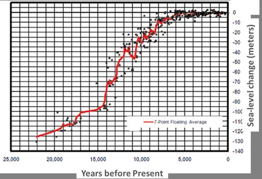
10 Sea Level Change 10
11 Areal Snapshots of Water Quality


12 Areal Profiles of TDS and Sulfate TDS 12 Sulfate

13 Areal Profiles of Chloride and Cl/Br Ratios Chloride 13 Cl/Br
14 Vertical Cross Sections of Water Quality
")
15 Hydrogeochemical Facies at Transect 3 (GMA 14) 15
")
16 Hydrogeochemical Facies at Transect 5 (GMA 15) 16
")
17 Hydrogeochemical Facies at Transect 8 (GMA 16) 17
")
18 Calcium Concentrations at Transect 34 (GMA 14) 18
")
19 Calcium Concentrations at Transect 56 (GMA 15) 19
")
20 Calcium Concentrations at Transect 8 (GMA 16) 20
21 Estimate of Groundwater Age

22 14 C Age (YBP) versus for Base of Chicot 22
23 14 C Age (YBP) versus for Top of Evangeline 23
24 14 C Age (YBP) versus for Base of Evangeline 24
25 Comparison of Groundwater Age Calculated from Field Data and Modeling Results Estimated Depth Range where Groundwater has an Age of 10,000 ybp Source of Depth Estimate Lissie Willis Upper Goliad Upper Lower Upper Lower Upper Lower Limit Limit Limit Limit Limit Limit 14 C Measurements Corrected LCRB Model Transect 34 GMA LCRB Model Transect 45 GMA Northern Gulf Coast Aquifer Transect 34 GMA 14 (1) (1) (1) (1) (1) (1) System GAM Northern Gulf Coast Aquifer Transect 45 GMA System GAM Central Gulf Coast Aquifer Transect 45 GMA System GAM Central Gulf Coast Aquifer Transect 8 GMA 16 (1) (1) (1) (1) (1) (1) System GAM GMA 16 AGM Transect 8 GMA 16 (1) (1) (1) (1) (1) Groundwater in formation is significantly older than 10,000 ybp. 25
26 Groundwater Flow Modeling
27 Reverse Particle Tracking To Estimate Groundwater Age Initial particles locations located along transects based at fixed elevations per 100 ft increments Particles are backtrack using a models pre-development water level conditions Time for particle to reach its recharge source at surface is the estimated age of groundwater 27

28 Reverse Particle Tracking To Estimate Groundwater Age 28

29 Reverse Particle Tracking To Estimate Groundwater Age 29


30 Recharge and Discharge Fluxes at Ground Surface for Predevelopment Conditions for LCRB Model 30


31 Recharge and Discharge Fluxes at Ground Surface for Predevelopment Conditions for Northern Gulf Coast GAM 31
32 Upward Migration of Formation Water Along Growth Faults
")
33 Meteoric and Compactional Circulation Pathways(from Dutton and others, 2006) 33
34 Elevated TDS in Formation Water in Catahoula 34

35 Mechanism for Upswelling of Brine Along Growth Faults( from Kuecher and others, 2001) 35

36 Evidence of Upswelling: Origin of Methane 36

37 Lines of Evidence for Upswelling of Formation Water Contribution to Elevated TDS Concentrations 37
38 Summary of Findings
39 Geochemical Analyses Analyses Method and/or Map Tabulated and plotted depthaverage geochemical values for the Gulf Coast Aquifer System Region Plots of hydrogeochemical facies, chloride values, and sand and salinity profiles along vertical cross-sections Analysis of carbon and isotope of gases such as carbon dioxide and methane 39 Insight Notable differences in the geochemistry of GMA 14, 15, and 16. These differences attributed to differences in climate, distribution of salt domes, and stratigraphy Direction of groundwater flow and evidence of recharge, mixing, and preferred-flow region within or between aquifers Evidence of movement along growth faults
40 Geochemical Analyses Analyses Method and/or Map Analysis of the hydropressure and brine concentrations in the Catahoula and deeper deposits Analysis of stable isotopes of oxygen and hydrogen Analysis of carbon stable and radioactive isotopes Insight Evidence that a source of the increased total dissolved solids (TDS) near the coast is upswelling of brine Evidence of meteoric water Estimate of groundwater age 40
41 Conceptual Flow Model The up-dip boundary for the regional Gulf Coast Aquifer System flow should be the Catahoula Formation outcrop; The downdip boundary for the regional Gulf Coast Aquifer System flow should allow groundwater to discharge across a large area of the ocean bottom; The numerical representation of the regional groundwater flow system should be constrained by estimates of groundwater age calculated from 14 C measurements; A conceptual water budget should be developed and be guided by recharge estimates by Scanlon and others (2012) after appropriate uncertainty estimates have been developed; 41
42 Conceptual Flow Model (con t) Proper conceptualization and representation of groundwater mixing and flow paths requires vertical layering smaller than the thicknesses of the major aquifers; and the utility and accuracy of the GAMs could be improved is model layers represented the geological formations that comprised the Chicot, Evangeline, and Jasper Aquifers, General head boundaries do not accurately model recharge to an aquifer and should not be used for that purpose in any future GAMs for the Gulf Coast Aquifer System, A continuous, low permeability Burkeville Confining Unit does not exist up dip at the outcrop; and 42
43 Questions
44 Backpocket Slides

45 Regional Models for GCAS Northern Gulf Coast Aquifer System GAM Central Gulf Coast Aquifer System GAM GMA 16 Alternative Groundwater Model Lower Colorado River Basin Model 45
46 Comparison of Corrected 14 C Age Based on NETPATH Modeling and Pearson Correction Soil to Recharge Well to Well 5-1, Well 5-3, Well 5-12, Well 5-13, or Well C MEAS ybp 8,940 12,280 6,730 9,340 7, C MEAS pmc C MEAS DIC δ 34 S meas Mass Transfer (1) calcite CO 2(g) Ca/Na Ex Mg/Na Ex K/Na Ex NaCl gypsum pyrite Computed Values 14 C ADJ (ybp) 1,019 2,456 1,579 4, C ADJ (pmc) δ 13 C DIC calc δ 34 S calc C ADJ (ybp) ,391 1,539 4,025 modern NOTES: 1 millmoles 2 Pearson Method 46

47 Reverse Particle Tracking To Estimate Groundwater Age Initial particles locations located along transects based at fixed elevations per 100 ft increments Particles are backtrack using a models pre-development water level conditions Time for particle to reach its recharge source at surface is the estimated age of groundwater 47

48 Reverse Particle Tracking To Estimate Groundwater Age 48

49 Reverse Particle Tracking To Estimate Groundwater Age 49

50 Reverse Particle Tracking To Estimate Groundwater Age 50

51 Transect 3 Sample (Aerial View) 51
")
52 Transect 3 Sample (Cross-section View) 52
53 Geochemical Parameters Sample No. Analyte Lab Dissolved Metals (Ca, Mg, 1 Na, K, Fe) TDS Alkalinity 2 ph San Specific Conductance Antonio Br, Cl, F, SO 4 (dissolved) Testing 3 Nitrate + Nitrite H 4 2 S HS 5 TOC Dissolved Fixed and hydrocarbon gas 6 composition 7 δc13 of C1, C2 Zymax 8 δd of C1, C2 9 δo18 of H20 10 δd of H20 Sample No. Analyte Lab 11 RSK 175 for C1, C2, C3 12 Gas extraction fee Total Gas for methane, ethane, propane, Zymax butane, and pentane(for 13 purpose of identifying thermo versus biogenic carbon sources) 14 δs34 of SO4 15 δo18 of SO4 University of Arizona Environme ntal Lab 16 δc13 of DIC C-14 Beta Analytics 53

54 Lithology for Transect 8 (GMA 16) 54
")
55 Calcium Concentrations at Transect 3 (GMA 14) 55
LSGCD STRATEGIC PLANNING FOR GROUNDWATER MANAGEMENT AND DEVELOPMENT PUBLIC STAKEHOLDER MEETING
 LSGCD STRATEGIC PLANNING FOR GROUNDWATER MANAGEMENT AND DEVELOPMENT PUBLIC STAKEHOLDER MEETING Prepared by LBG-Guyton Associates May 24, 2016 PLANNING STUDY OUTLINE Task 0 Task 1 Project Communications
Development of Groundwater Model for GMA-12 Using a Participatory Framework for Data Collection and Model Calibration
 Generalized Flowchart of Proposed Project Activities Development of Groundwater Model for GMA-12 Using a Participatory Framework for Data Collection and Model Calibration Submitted to: Texas Water Development
Gas-Water-Rock Interactions in Saline Aquifers Following CO 2 Injection: Results from Frio Formation, Texas, USA
 Gas-Water-Rock Interactions in Saline Aquifers Following CO 2 Injection: Results from Frio Formation, Texas, USA GCCC Digital Publication Series #05-03e Y. K. Kharaka D. R. Cole W. D. Gunter J. J. Thordsen
Groundwater Flow Evaluation and Spatial Geochemical Analysis of the Queen City Aquifer, Texas
 Groundwater Flow Evaluation and Spatial Geochemical Analysis of the Queen City Aquifer, Texas Abstract The Queen City Aquifer is a saturated sandstone unit in the coastal plain of East Texas. The goals
Groundwater Monitoring Protocols for Seawater Intrusion Example of Challenges and Experiences in a Coastal Groundwater Basin
 Groundwater Monitoring Protocols for Seawater Intrusion Example of Challenges and Experiences in a Coastal Groundwater Basin KATHLEEN KUEPPER UNITED WATER CONSERVATION DISTRICT Outline Sustainable Groundwater
Scientific Evaluation and Interpretation of Baseline Groundwater Well Testing Data Available for Alberta
 Scientific Evaluation and Interpretation of Baseline Groundwater Well Testing Data Available for Alberta Bernhard Mayer, Pauline Humez, Leah Wilson & Michael Nightingale Department of Geoscience University
Class III In Situ Uranium Injection Wells and Aquifer Exemptions in Texas: Multiple Levels of Permitting Protection for USDW Protection
 Class III In Situ Uranium Injection Wells and Aquifer Exemptions in Texas: Multiple Levels of Permitting Protection for USDW Protection David Murry Geologist Radioactive Materials Division TCEQ Historical
Sections 5 & 6. Site Characterization and Lines of Evidence. Steve Posten
 Sections 5 & 6 Site Characterization and Lines of Evidence Steve Posten Overview Section 5 Site Characterization Conceptual site model Aquifer characteristics Hydraulic conductivity/gradient Porosity Organic
AQUIFERS OF THE SAN ANTONIO RIVER BASIN
 AQUIFERS OF THE SAN ANTONIO RIVER BASIN OBJECTIVES Explain what an aquifer is Identify the major aquifers located in the San Antonio River Basin Explain the difference between porosity and permeability
STRAWMAN OUTLINE March 21, 2008 ISWS/ISGS REPORT ON THE OPPORTUNITIES AND CHALLENGES OF MEETING WATER DEMAND IN NORTH-EAST ILLINOIS
 STRAWMAN OUTLINE March 21, 2008 ISWS/ISGS REPORT ON THE OPPORTUNITIES AND CHALLENGES OF MEETING WATER DEMAND IN NORTH-EAST ILLINOIS REPORT TO BE DELIVERED TO THE RWSPG BY SEPTEMBER 30, 2008 Table of Contents
Isotope hydrology: Stable isotopes in water resources assessment IAEA International Atomic Energy Agency
 Isotope hydrology: Stable isotopes in water resources assessment Luis Araguás Workshop on Flow-path characterization, Munich, 29 June 2010 International Atomic Energy Agency Isotope Hydrology Section Outline
Water Chemistry 4. Use of Chemical Analyses to Interpret Ground Water Systems
 Water Chemistry 4 Use of Chemical Analyses to Interpret Ground Water Systems When groundwater flows through rocks their minerals dissolve gradually rarely reaching their solubility limit So their CONCENTRATION
What is Isotope Hydrology Application of geochemical methods involving analyses of environmental isotopes (naturally occurring stable isotopes and uns
 Isotope Hydrology and Source-Water Protection: an Investigation from Lafayette Parish, Louisiana Bruce K. Darling, Ph.D. Geochemist/Hydrogeologist LBG-Guyton Guyton Associates Lafayette, Louisiana What
Hydrogeology of a shallow coalbed methane play: A case study of Ardley coal in west- central, Alberta
 Hydrogeology of a shallow coalbed methane play: A case study of Ardley coal in west- central, Alberta S.M. Harrison, M.Sc., P.Geol., P.Geo. SH Consulting Services In association with NLR Associates Inc.
J. Daniel Arthur, P.E., ALL Consulting. Author. Ground Water Protection Council January 2009 San Antonio, Texas. Presented at
 Prudent and Sustainable Water Management and Disposal Alternatives Applicable to Shale Gas Development Author J. Daniel Arthur, P.E., ALL Consulting Presented at Ground Water Protection Council January
Warm Mineral Springs Sampling by Sarasota County
 Warm Mineral Springs Sampling by Sarasota County John Ryan, Kathryn Meaux, Rene Janneman and Jon S. Perry Sarasota County Environmental Services Sarasota, Florida September 11 Warm Mineral Springs is a
Appendix A: Measurement Performance Specifications (Tables A7.1 and A7.2)
") Appendix A: Measurement Performance Specifications (Tables A7.1 and A7.2) Measurement performance specifications define the data quality needed to satisfy project objectives. To this end, measurement performance
Appendix A: Measurement Performance Specifications (Tables A7.1 and A7.2) Measurement performance specifications define the data quality needed to satisfy project objectives. To this end, measurement performance
Geology 627, Hydrogeology Review questions for final exam h t 1/ 2
 Geology 67, Hydrogeology Review questions for final exam 004 Multiple choice and fill in the blank. There may be more than one correct choice for each question. 1. Which hydrogeologic quantities are represented
TIERED APPROACH TO EVALUATION AND MANAGEMENT OF PRODUCED WATER IMPACTS ON GROUNDWATER RESOURCES
 TIERED APPROACH TO EVALUATION AND MANAGEMENT OF PRODUCED WATER IMPACTS ON GROUNDWATER RESOURCES Shawn M. Paquette, P.E., BCEE, John A. Connor, P.E., P.G., BCEE, Lisa J. Molofsky, P.G., Kenneth L. Walker,
Desalination Report TRANS TEXAS WATER PROGRAM SOUTHEAST AREA. Technical Memorandum. February 20, 1998
 TRANS TEXAS WATER PROGRAM SOUTHEAST AREA Technical Memorandum Desalination Report February 20, 1998 Sabine River Authority of Texas Lower Neches Valley Authority San Jacinto River Authority City of Houston
Groundwater Management Plan
 Groundwater Management Plan 21-215 Adopted by Board Resolution and Order No. 1-1-645 on October 12, 21 Approved by the Texas Water Development Board on January 5, 211 Table of Contents 1. BACKGROUND INFORMATION...
Raw Water Supply Master Plan Development
 Raw Water Supply Master Plan Development Stakeholder Outreach Meeting - II 31 August 2016 Welcome Introductions Master Plan Goals and Objectives Refine our standard approach to long-term plan for securing
Salt Water Intrusion in Coastal Aquifers March, 2015 L. Pilgrim, P.Geo.
 Salt Water Intrusion in Coastal Aquifers March, 2015 L. Pilgrim, P.Geo. Agenda 1. What is SWI? 2. What are the causes? 3. Indicator parameters of SWI 4. What is happening in our region? 5. Conclusions
Lecture 20: Groundwater Introduction
 Lecture 20: Groundwater Introduction Key Questions for Groundwater 1. What is an aquifer? 2. What is an unconfined aquifer? 3. What is groundwater recharge? 4. What is porosity? What determines the magnitude
The effect of Hilti / Salahi Recharge Dam in Batineh Area, Sultanate of Oman on the Quality of Groundwater Using GIS
 The effect of Hilti / Salahi Recharge Dam in Batineh Area, Sultanate of Oman on the Quality of Groundwater Using GIS William Bajjali University of Wisconsin Superior, Department of Biology & Earth Sciences,
USGS Groundwater Quality Assessment in the Williston Basin
 USGS Groundwater Quality Assessment in the Williston Basin Joel Galloway Acting Director USGS North Dakota Water Science Center ND Water Quality Monitoring Conference Bismarck, ND March 2-4, 2016 U.S.
UNDERGROUND INJECTION AND SEQUESTRATION AND UNDERGROUND SOURCES OF DRINKING WATER (PROTECTING A VALUABLE RESOURCE)
") UNDERGROUND INJECTION AND SEQUESTRATION AND UNDERGROUND SOURCES OF DRINKING WATER (PROTECTING A VALUABLE RESOURCE) Presented by Richard Brown Subsurface Technology, Inc. INTRODUCTION Continued population
UNDERGROUND INJECTION AND SEQUESTRATION AND UNDERGROUND SOURCES OF DRINKING WATER (PROTECTING A VALUABLE RESOURCE) Presented by Richard Brown Subsurface Technology, Inc. INTRODUCTION Continued population
Investigation of water displacement following large CO 2 sequestration operations
 Investigation of water displacement following large CO 2 sequestration operations GCCC Digital Publication Series #8-3g Jean-Philippe Nicot Susan D. Hovorka Jong-Won Choi Keywords: Pressure pulse; updip
Laboratory Fee Schedule
 JMLord, Inc. Laboratory Fee Schedule Spring 2011 www.jmlordinc.com 267 N. Fulton St. Fresno CA, 93705 (559) 268-9755 (559) 486-6504 (FAX) Laboratory Services Since 1976, JMLord, Inc. has provided consultants
OBSTACLES TO COMPLETE PCE DEGRADATION DURING REDUCTIVE DECHLORINATION
 OBSTACLES TO COMPLETE PCE DEGRADATION DURING REDUCTIVE DECHLORINATION Judie A. Kean, Florida Department of Environmental Protection, Tallahassee, Florida, USA; Duane Graves, Dgraves@GeoSyntec.com, (GeoSyntec
Indirect Reuse with Multiple Benefits The El Monte Valley Mining, Reclamation, and Groundwater Recharge Project
 ABSTRACT & POWERPOINT PRESENTATION Indirect Reuse with Multiple Benefits The El Monte Valley Mining, Reclamation, and Groundwater Recharge Project Tim Smith Principal Engineer Helix Water District La Mesa,
Subsidence of Land Caused by Ground-Water Pumping
 University of Colorado Law School Colorado Law Scholarly Commons Groundwater: Allocation, Development and Pollution (Summer Conference, June 6-9) Getches-Wilkinson Center Conferences, Workshops, and Hot
Assessment of Groundwater Resources in Kirana Hills Region, Rabwah, District Chiniot, Pakistan
 Open Access ISSN: 2223-957X Assessment of Groundwater Resources in Kirana Hills Region, Rabwah, District Chiniot, Pakistan Mirza Naseer Ahmad*, Rashida Sultana, Maria Salahuddin, Jaleed S. Ahmad Abdus
Interpretation of Chemistry Data from Seepage, Observation Well, and Reservoir Water Samples collected at Horsetooth Dam during July 2004
 Interpretation of Chemistry Data from Seepage, Observation Well, and Reservoir Water Samples collected at Horsetooth Dam during July 2004 TSC Technical Memorandum No. 8290-04-02 by Doug Craft, Research
Operation of Hydranautics New ESNA Membrane at St. Lucie West, FL Softening Plant
 Ilan Wilf & Scott Rappoport, Operation of Hydranautics New ESNA Membrane at St. Lucie West, FL Softening Plant Introduction St. Lucie West, Florida Service Distrcit employed the first large scale reverse
Coffin Bay Groundwater Lens A. Resource Assessment
 N. Somaratne, H. Zulfic, B. Swaffer and G. Ashman 25 November 29 Contents Executive Summary 6 1. INTRODUCTION 7 1.1 Background 7 1.2 Objectives 7 2. GEOLOGY AND HYDROGEOLOGY 7 2.1 Geology 7 2.2 Hydrogeology
Remediation of Sodium Contaminated Sites
 Remediation of Sodium Contaminated Sites..\..\3918b1ca23763e9e9a12ffd67acb0ceb.jpg 21 st International Petroleum Environmental Conference, Houston, Texas Mark Landress P.G. Project Navigator, Ltd. 10497
pdfmachine trial version
 IRRIGATION WATER QUALITY OF DIFFERENT AREAS OF PUNJAB By Amina Mumtaz* and Zia-ur-Rehman Abstract: A detailed study was conducted in different areas of Punjab inorder to access the suitability of water
Hilmar Cheese Company, Hilmar, Merced County, California. On behalf of Hilmar Cheese Company (HCC), Jacobson James & Associates, Inc.
, Jacobson James & Associates, Inc.") May 13, 2009 Mr. Jan Alfson California Regional Water Quality Control Board Fresno Branch Office 1685 E Street Fresno, CA 93706 Subject: Data Gap Work Plan Addendum Hilmar Cheese Company, Hilmar, Merced
May 13, 2009 Mr. Jan Alfson California Regional Water Quality Control Board Fresno Branch Office 1685 E Street Fresno, CA 93706 Subject: Data Gap Work Plan Addendum Hilmar Cheese Company, Hilmar, Merced
ENVIRONMENTAL HYDROGEOLOGY
 ENVIRONMENTAL HYDROGEOLOGY m LEWIS Mostafa M. Soliman Professor, Faculty of Engineering Ain Shams University Cairo, Egypt Philip E. LaMoreaux Senior Hydrogeologist Bashir A. Memon Executive Vice President
TSUNAMI DISASTER AND GROUNDWATER RESOURCES: THE SOUTHEASTERN COAST OF INDIA. Bhanu Neupane Regional Hydrologist, UNESCO
 TSUNAMI DISASTER AND GROUNDWATER RESOURCES: THE SOUTHEASTERN COAST OF INDIA Bhanu Neupane Regional Hydrologist, UNESCO Background On December 26, 2004, Tsunami waves struck the coast of the Indian subcontinent
Water Desalination. Prestige World Wide
 Water Desalination Prestige World Wide November 8, 2011 Outline 1. Fresh Water Situation John Ross Norton 2. History of Desalination Paige Guilbeaux 3. Desalination Process Rachael Solari 4. Economic Feasibility
Research into the Characterization of Brackish Water and Disposal of Desalination Reject Water in Saline Aquifers and Depleted Oil and Gas Reservoirs
 1 Research into the Characterization of Brackish Water and Disposal of Desalination Reject Water in Saline Aquifers and Depleted Oil and Gas Reservoirs Edited by Ric Jensen, Assistant Research Scientist,
World Class CO 2 Sequestration Potential in Saline Formations, Oil and Gas Fields, Coal and Shale:
 World Class CO 2 Sequestration Potential in Saline Formations, Oil and Gas Fields, Coal and Shale: The U.S. Southeast Regional Sequestration Partnership has it All! SPE 126619 Authors: Robin Petrusak,
Groundwater Quality in the Red River Basin and Rolling Plains in Texas
 Groundwater Quality in the Red River Basin and Rolling Plains in Texas Srinivasulu Ale Assistant Professor (Geospatial Hydrology) Sriroop Chaudhuri Postdoctoral Research Associate Texas A&M AgriLife Research,
Evaluation of Hydrologic Connection between San Marcos Springs and Barton Springs through the Edwards Aquifer
 San Marcos Springs and Barton Springs through the Edwards Aquifer Prepared for: Guadalupe Blanco River Authority Prepared by: San Marcos Springs and Barton Springs through the Edwards Aquifer Prepared
Arsenic in the Landfill Environment: Untested Ideas and Open Questions
 Arsenic in the Landfill Environment: Untested Ideas and Open Questions SBRP Arsenic Conference Arsenic and Landfills: Protecting Water Quality Boston, MA October 3-4, 2006 Bill Brandon, EPA NE Acknowledgements
Evaluating Surface Casing Depths of Oil & Gas Operations in an Effort to Protect Local Groundwater: A GIS Enabled Process
 Evaluating Surface Casing Depths of Oil & Gas Operations in an Effort to Protect Local Groundwater: A GIS Enabled Process by Mary Elaine Nienkamp A Thesis Presented to the Faculty of the USC Graduate School
Water Chemistry. Water 101
 Water Chemistry Water 101 I. Introduction A. Water is not pure Many different kinds of chemicals dissolved in it Ions, organic chemicals, organic matter, particulate matter, and gases can all be in water
Advanced Tools for Subsurface Sampling and Analysis
 Advanced Tools for Subsurface Sampling and Analysis 220 William Pitt Way Pittsburgh, PA 15238 412-286-5245 www.pacelabs.com Advanced Tools TABLE OF CONTENTS: 1. Table of Contents 2. Introduction 3. PAES
Tenmile Creek Sampling Summary
 Tenmile Creek Sampling Summary December 15, 2015 Background In 2014, DEP s California District Mining Office collected surface water samples from three locations on Tenmile Creek (TMC) in the vicinity
SALINISATION OF THE NORTHERN COASTEL AREA OF THE NETHERLANDS DUE TO LAND SUBSIDENCE AND SEA LEVEL RISE
 SALINISATION OF THE NORTHERN COASTEL AREA OF THE NETHERLANDS DUE TO LAND SUBSIDENCE AND SEA LEVEL RISE PERRY DE LOUW AND GUALBERT OUDE ESSINK TNO Geological Survey of the Netherlands P.O. Box 815, 358TA
East TX Test Site (1/2 Treated)
") 1 East TX Test Site (1/2 Treated) 2 CATION EXCHANGE CAPACITY ( CEC ) It is a measure of the quantity of cations reversibly adsorbed per unit weight of soil. CEC is expressed in meq/100 g of mass (meq is
1 East TX Test Site (1/2 Treated) 2 CATION EXCHANGE CAPACITY ( CEC ) It is a measure of the quantity of cations reversibly adsorbed per unit weight of soil. CEC is expressed in meq/100 g of mass (meq is
Christchurch groundwater quality monitoring
 Christchurch groundwater quality monitoring Environment Canterbury Report prepared for Christchurch City Council by Groundwater Quality Team Environment Canterbury ISBN: Report No. R14/68 978-1-927314-14-2
WHY CARBON? The Carbon Cycle 1/17/2011. All living organisms utilize the same molecular building blocks. Carbon is the currency of life
 The Carbon Cycle WHY CARBON? Inventories: black text Fluxes: purple arrows Carbon dioxide (+4) AN = 6 (6P/6N) AW = 12.011 Oxidation: -4 to +4 Isotopes: 11 C, 12 C, 1 C, 14 C Methane (-4) Carbon is the
GROUNDWATER General Facts and Concepts
 GROUNDWATER General Facts and Concepts General schematic of hydrologic cycle. As the term implies, water moves within the cycle and groundwater (aquifer) is just one zone of the cycle. Aquifers and Wells
Drought and population growth have
 46 Brady, Kottenstette, Mayer, Hightower UNIVERSITIES COUNCIL ON WATER RESOURCES ISSUE 132, PAGES 46-51, DECEMBER 2005 Inland Desalination: Challenges and Research Needs Patrick V. Brady, Richard J. Kottenstette,
A Critical Review of the Risks to Water Resources from Unconventional Shale Gas Development and Hydraulic Fracturing in the United States
 pubs.acs.org/est A of the Risks to Water Resources from Unconventional Shale Gas Development and Hydraulic Fracturing in the United States Avner Vengosh,*, Robert B. Jackson,, Nathaniel Warner, Thomas
PEACH CREEK A NATURALLY ACIDIC DRAINAGE NEAR GIBBONS CREEK LIGNITE MINE, TEXAS 1. Jan K. Horbaczewski 2. Abstract
 PEACH CREEK A NATURALLY ACIDIC DRAINAGE NEAR GIBBONS CREEK LIGNITE MINE, TEXAS 1 by Jan K. Horbaczewski 2 Abstract Peach Creek near Gibbons Creek lignite mine in east-central Texas offers an example of
Considerations for hydraulic fracturing and groundwater and surface water protection: lessons learned in the U.S.
 Considerations for hydraulic fracturing and groundwater and surface water protection: lessons learned in the U.S. Robert W. Puls, Ph.D. Director, Oklahoma Water Survey University of Oklahoma Hydraulic
Nitrate is also the #1 drinking-water contaminant in California groundwater:
 Lawrence Livermore National Laboratory Nitrate is also the #1 drinking-water contaminant in California groundwater: Denitrification and nitrate transport in groundwater underlying dairy operations in California
The Carbon cycle. Atmosphere, terrestrial biosphere and ocean are constantly exchanging carbon
 The Carbon cycle Atmosphere, terrestrial biosphere and ocean are constantly exchanging carbon The oceans store much more carbon than the atmosphere and the terrestrial biosphere The oceans essentially
Simulating the Performance of a Dry Stack Tailings Design for Water Control Permitting
 Simulating the Performance of a Dry Stack Tailings Design for Water Control Permitting Amy Hudson 1, April Hussey 1, Andrew Harley 1 and Timothy M. Dyhr 2 1. Tetra Tech, USA 2. Nevada Copper Corp., USA
Two Oklahoma Corporation Commission Programs to Protect. Patricia Billingsley Oklahoma Corporation Commission Oil and Gas Conservation Division
 Two Oklahoma Corporation Commission Programs to Protect Water Supplies Patricia Billingsley Oklahoma Corporation Commission Oil and Gas Conservation Division Today I will be talking about the two of the
Oil Sands Water Disposal Challenges
 WATER WASTE ENERGY Oil Sands Water Disposal Challenges Considerable volumes of in-situ blowdown and mine de-pressurization water generated in future SAGD blowdown quality (30,000 mg/l TDS or more) Primarily
Carbon Cycle Midterm Exam April 1, Answer Key
 Carbon Cycle Midterm Exam April 1, 2008 Answer Key 1. a. What process dominates the seasonal cycle in atmospheric O 2 at 41 S? Southern summer release and southern winter uptake by the ocean. Part due
State of Our Water Resource Management Programs
 State of Our Water Resource Management Programs Presentation to Bentwater Civic Association June 23, 2016 PDF of Presentation Available on website home page: http://lakeconroecn.com History and Status
Modeling the Managed Aquifer Recharge for Groundwater Salinity Management in the Sokh River Basin
 Modeling the Managed Aquifer Recharge for Groundwater Salinity Management in the Sokh River Basin A. Karimov, 1 I. Gracheva, 2 F. Miryusupov 2 1 International Water Management Institute (IWMI) Central
Legislative Statistics
 State Legislative Update Texas Water 2011 April 6, 2011 Carol Batterton, Water Environment Association of Texas 82 nd Session Texas Legislature Key Dates November 8, 2010: Pre filing of bills began January
Application of ORP for the characterisation of the ground drinking water under changing climate conditions
 Application of ORP for the characterisation of the ground drinking water under changing climate conditions L. Kliučininkas, V. Račys, D. Pečiulytė, E. Petkevičienė Lithuania: River Basin Districts Šešupė
Recent Advances in the Analytical Methods Used for Shale Gas Reservoir Gas-in-Place Assessment*
 Recent Advances in the Analytical Methods Used for Shale Gas Reservoir Gas-in-Place Assessment* By Robert C. Hartman 1, Pat Lasswell 2, and Nimesh Bhatta 1 Search and Discovery Article #40317 (2008) Posted
November 30, Jean Moran (CSU East Bay), Brad Esser, Michael Singleton (Lawrence Livermore National Laboratory)
, Brad Esser, Michael Singleton (Lawrence Livermore National Laboratory)") November 30, 2012 Jean Moran (CSU East Bay), Brad Esser, Michael Singleton (Lawrence Livermore National Laboratory) Presentation Outline Overview of State Water Resources Control Board GAMA program Analytical
November 30, 2012 Jean Moran (CSU East Bay), Brad Esser, Michael Singleton (Lawrence Livermore National Laboratory) Presentation Outline Overview of State Water Resources Control Board GAMA program Analytical
Otter Creek Watershed TMDL Project. Stakeholder Meeting June 6, 2013
 Otter Creek Watershed TMDL Project Stakeholder Meeting June 6, 2013 1 Meeting Purpose Meet with watershed & technical advisory group members and watershed landowners to provide basic Otter Creek TMDL project
Using Basic Chemistry in Interpreting Water Source, Age, and Trends KIMM CRAWFORD
 Using Basic Chemistry in Interpreting Water Source, Age, and Trends KIMM CRAWFORD Inver Grove Heights Galena Aquifer Prairie du Chien Aquifer Inver Grove Heights Manganese Study - 2015 Almost three-quarters
FIGURE 2.1. REGIONAL WATER PLANNING AREAS.
 FIGURE 2.1. REGIONAL WATER PLANNING AREAS. Panhandle (A) Llano Estacado (O) Region B Region C North East Texas (D) Brazos G Region F East Texas (I) Far West Texas (E) Plateau (J) Lower Colorado (K) Region
Groundwater Surface Water Interaction. Methods and Case Studies
 Groundwater Surface Water Interaction Methods and Case Studies Stephan M. Weise UFZ-Department of Isotope Hydrology Groundwater Surface Water Interaction is a process relevant for... Salinisation of fresh
GROUNDWATER RESOURCE MANAGEMENT FUNDAMENTALS: GROUNDWATER BASIN CONNECTIVITY. Open-File Report May 2014
 GROUNDWATER RESOURCE MANAGEMENT FUNDAMENTALS: GROUNDWATER BASIN CONNECTIVITY Open-File Report 2014-03 May 2014 from CA Department of Water Resources, 1989 THIS REPORT IS PRELIMINARY AND IS SUBJECT TO MODIFICATION
Water testing performed in 2010 PWSID#: This report was prepared by: Harris County WCID #1 125 San Jacinto Highlands, TX 77562
 WATER ANNUAL W QUALITY REPORT Water testing performed in 2010 PWSID#: 1010159 This report was prepared by: Harris County WCID #1 125 San Jacinto Highlands, TX 77562 Este reporte incluye informacion importante
Hybrid RO & Softening Birjand Water Treatment Plant
 Hybrid RO & Softening Birjand Water Treatment Plant Ali Farahmand 1 *, Nassir Gifani 1, and Mohsen Farivar 1 1 ToossAb Consulting Engineers Co., Tehran, Iran (*correspondence: farahmandali@yahoo.com) FORMAT:
Energy, Greenhouse Gases and the Carbon Cycle
 Energy, Greenhouse Gases and the Carbon Cycle David Allen Gertz Regents Professor in Chemical Engineering, and Director, Center for Energy and Environmental Resources Concepts for today Greenhouse Effect
Watershed: an area or ridge of land that separates waters flowing to different rivers, basins, or seas. It is the interdependent web of living
 Watershed: an area or ridge of land that separates waters flowing to different rivers, basins, or seas. It is the interdependent web of living organisms that inhabit a geographic area and depend on it
Subsurface Distribution of ZVI/EHC Slurry Validating Radius of Influence. Josephine Molin, PeroxyChem October
 Subsurface Distribution of ZVI/EHC Slurry Validating Radius of Influence Josephine Molin, PeroxyChem October 2 2014 Presentation Objective / Outline To empirically summarize our experience from a range
Review of Groundwater Information in the Lower Mekong Basin
 Review of Groundwater Information in the Lower Mekong Basin Khem Sothea Hydrology Team (Component-2) 17-19 February 2014 Bangkok & Khon Kean, Thailand FIRST MISSION OF USGS IN THE LMB (April 27 July 22,
Characterizing the Groundwater-Surface Water Interactions in Different Subsurface Geologic Environments Using Geochemical and Isotopic Analyses
 Characterizing the Groundwater-Surface Water Interactions in Different Subsurface Geologic Environments Using Geochemical and Isotopic Analyses By Molly M. Long Submitted to the graduate degree program
Investigation of the Coastal Lowlands Aquifer System
 Investigation of the Coastal Lowlands Aquifer System Michael Bradley, Linzy Foster, and Brian Clark U.S. Geological Survey Alabama Water Resources Conference and Symposium Sept 7-9, 2016 The information
USING NITRATE, CHLORIDE, SODIUM, AND SULFATE TO CALCULATE GROUNDWATER AGE
 USING NITRATE, CHLORIDE, SODIUM, AND SULFATE TO CALCULATE GROUNDWATER AGE Kimm Crawford Crawford Environmental Services, 44918 W Pelican Drive, Watertown, SD 57201, USA, kcraw@itctel.com Terry Lee Olmsted
Florida s Class I Water Treatment Injection Wells. Joseph Haberfeld, P.G. UIC Program, FDEP January, 2013
 Florida s Class I Water Treatment Injection Wells Joseph Haberfeld, P.G. UIC Program, FDEP January, 2013 Source: U.S. Geological Survey Source: elmhurst.edu 120 Class I Injection Wells - 2010 108 100
Groundwater Monitoring along the Animas River, New Mexico: Summary of Groundwater Hydraulics and Chemistry from August 2015 to June 2016
 Upper Cretaceous Paleocene New Mexico Bureau of Geology and Mineral Resources Groundwater Monitoring along the Animas River, New Mexico: Summary of Groundwater Hydraulics and Chemistry from August 2015
Regulation of In Situ Mining in Texas
 Special GWPC Presentation Regulation of In Situ Mining in Texas Presented by Susan Jablonski and David Murry, Texas Commission on Environmental Quality Tuesday, October 28, 2008 Austin, Texas Overview
Determining the Salinity of Groundwater for Regulatory Purposes in Alberta
 Determining the Salinity of Groundwater for Regulatory Purposes in Alberta Brent Welsh, P.Eng. District Hydrogeologist Alberta Environment and Water Operations, Northern Region Banff, Alberta April 12,
Importance of Groundwater to the US Economy
 Importance of Groundwater to the US Economy Venkatesh Uddameri, Ph.D., P.E. Professor of Civil & Environmental Engineering Water Resources Center, Texas Tech University, Lubbock Kevin McCray, Executive
U.S. Water Budget. Figure Source:Data from The Nation s Water Resources , Vol. 1, U.S. Water Resources Council.
 U.S. Water Budget Figure 10.18 10-9 Source:Data from The Nation s Water Resources 1975-2000, Vol. 1, U.S. Water Resources Council. Average U.S. Precipitation Figure 10.19 10-10 Source: U.S. Water Resources
Concentration mg/l TDS mg/l 10, ,000 Recovery 75% Waste TDS mg/l 44,000 COD mg/l 3,500 0 BOD NTU 1,250 0 Power Used kwh/m3 2.
 1326 North Trinity San Antonio, TX 78207 1 Test Report Frac/Produced Water September 2012 A test was run in 2012 using model P-6 four stages in series. The test was run at 900 LPH (approx 4 GPM, 135 BPD).
Study Justification. Coordinated Resource Management Project Little Snake River Conservation District
 Trends in Surface-Water Quality of the Muddy Creek asin: Carbon County, Wyoming C.. Ellison, Q. D. Skinner and L. S. Hicks Department of Renewable Resources University of Wyoming Funded by: Little Snake
By Laura A. Sacks. U.S. Geological Survey. Water-Resources Investigations Report
 Geochemical and Isotopic Composition of Ground Water with Emphasis on Sources of Sulfate in the Upper Floridan Aquifer in Parts of Marion, Sumter, and Citrus Counties, Florida By Laura A. Sacks U.S. Geological
Recovery & Concentrate Management
 WRRC 2011 Annual Conference, Yuma AZ April 26 th & 27th Recovery & Concentrate Management A Quick Look at Three Local Projects Guy W. Carpenter, PE Vice President, Water Supply & Reuse How do we make use
Purpose. Utilize groundwater modeling software to forecast the pumping drawdown in a regional aquifer for public drinking water supply
 MODFLOW Lab 19: Application of a Groundwater Flow Model to a Water Supply Problem An Introduction to MODFLOW and SURFER The problem posed in this lab was reported in Chapter 19 of "A Manual of Instructional
Storm Surge Mitigation: Status and Questions. Scott A. Jones Director of Advocacy Galveston Bay Foundation
 Storm Surge Mitigation: Status and Questions Scott A. Jones Director of Advocacy Galveston Bay Foundation Galveston Bay Foundation Mission: To preserve, protect, and enhance the natural resources of Galveston
Comparison of Recharge Estimation Methods Used in Minnesota
 Comparison of Recharge Estimation Methods Used in Minnesota by Geoffrey Delin, Richard Healy, David Lorenz, and John Nimmo Minnesota Ground Water Association Spring Conference Methods for Solving Complex
Importance of River Water Recharge to Selected California Groundwater Basins Groundwater Resources Association of California 2016 Conference
 Importance of River Water Recharge to Selected California Groundwater Basins Groundwater Resources Association of California 2016 Conference September 29, 2016 Concord, CA Ate Visser, Jean E. Moran*, Michael