Hydrology Review, New paradigms, and Challenges
|
|
|
- Jerome Brown
- 6 years ago
- Views:
Transcription

1 Hydrology Review, New paradigms, and Challenges Intent quick introduction with emphasis on aspects related to watershed hydrochemistry and new paradigms


2 Watershed / Catchment Definition Portion of landscape that drain into a river, creek, stream, lake or any water body Typically defined by surface topography DEM, contours, etc.
3 Can be defined using a DEM e.g., Archer Creek catchment in the Adirondacks, USA. 3 m DEM Assumed that no water beyond the boundaries of the catchment contributes to runoff in the catchment very often this is violated and groundwaters beyond surficial boundaries may contribute. Especially in cases of flat landscapes with deep aquifers.

4 Components or parts of a watershed Atmosphere Vegetation or Forest canopy Forest floor or litter layer Soils Regolith Bedrock Streams Water bodies Forest canopy Forest floor Soil profile / rhizosphere


5 wetlands hillslopes Proportion of the watershed as well as the spatial location matters!


6 Lakes, ponds Streams, riparian zones, alluvial zones Hydrologic connectivity
7 All these components/parts of the catchment play an important role in influencing runoff amounts, flowpaths, timing (residence time) and chemistry Each of these parts of the catchment have a unique influence on hydrology and biogeochemical response Relative influence of these parts will vary with location and scale of the catchment Streamflow response is an integrated (in many cases) sum of all these parts Our interest look at the integrated response and determine how each of these parts make up the response

8 REVIEW - Hydrologic cycle and Hydrologic processes
9 Hydrologic budget Water balance P + Gin Q ET Gout = ΔS Assumptions in small catchment research?

10 Different flow paths have different transit times and therefore unique chemical signatures Proportion of old and new waters or water age may vary with flow paths
11
12 The various hydrologic components/processes affected by Climate Topography Soils Vegetation Geology Landuse


13 Precipitation Rainfall, snowfall, ice storms Amount Intensity Duration Frequency/return-period Timing/seasonal -- convective versus frontal storms; storms associated with hurricanes / marine influences Spatial variation a factor in the response of large watersheds or catchments Antecedent moisture conditions Antecedent freeze-thaw conditions Rain on snow events


14 Snowpack / Snowmelt Presence or absence of snow cover or snow pack - Critical factor in biogeochemical response of catchments -- Why????? Snowpack and snowmelt - Significant in the northeast, Mountainous West - Primary driver of hydrology and catchment response. Generates big differences in the annual discharge curve! Not as significant in Mid-Atlantic or the South USA


15 Interception canopy or forest floor Definition Water collected or intercepted by the vegetation canopy or the litter layer water which does not reach the soil surface for infiltration or runoff.
16 Factors - Meteorological Factors Intensity Size Duration Wind speed Air temperature Vegetation Characteristics: Vegetation (crown) form conifer, deciduous, grasses Plant physiology Density Community structure Will influence the response of streamflow at the watershed outlet amount and timing
17 Interception varies with vegetation type high for conifers versus deciduous! (on an annual basis) Interception for conifers 10 to 50% of annual precip For non-conifers = 10 to 35% of annual precip. (will vary with leaf cover or LAI leaf area index)

18 Throughfall and stemflow
 figures showing throughfall and stemflow input in the soil")
19 Throughfall and stemflow - play an important role in differential input of precipitation to the soil surface. This differential input facilitates preferential flow in soils Liang et al s 2011 (Water Resources Research) figures showing throughfall and stemflow input in the soil Which trees have the highest amounts of stemflow and why?

20 Stemflow Photo credit Delphis Levia
21 Evapotranspiration Definition Conversion of water to vapor and its transport away from the evaporating surface. Solar radiation main driving source Losses occur from: water accumulated on plant surfaces - evaporation loss from plant stomata transpiration loss from water and soil surfaces -evaporation Significance: ET losses could be as high as 90% in arid climates - typically around 40 to 70% in humid climates 400 to 900 mm/yr Strong controls on hydrologic response in arid climates
22 ET Losses maximum during summer Max during late noon Can vary spatially based on aspect and soil depth

23 ET Losses maximum during summer Max during late noon Can vary spatially based on aspect and soil depth
24 Primary meteorological factors affecting ET: 1. Radiation (MJ m-2 day-1 or W m-2 or Langleys day-1) 2. Vapor Pressure (kpa) 3. Wind speed (m/s) 4. Air temperature (degrees C) 5. Relative Humidity (%) Plant-water factors: 1. leaf area index (leaf cover) 2. root depth (availability of water to the transpiring surface) Soil-water factors: 1. soil moisture 2. hydraulic conductivity (rate at which water moves through the soil medium to the surface or the root)

25 Mean Annual Lake Evaporation

26 Infiltration Definition - entry of water into the soil surface as a distinct wetting front Some soil definitions first! Porosity Saturation Bulk density Field capacity Drainable porosity Wilting point

27 Porosity Saturation Bulk density and porosity Field capacity Drainable porosity Wilting point

28 A typical infiltration pattern in non-sandy soils.
29 Start of infiltration Soil pores are empty Infiltration occurs rapidly Latter stages of infiltration Soil pores are filled with Water infiltration rate Controlled by saturated conductivity
30 Infiltration rates initially are very high but gradually decrease with time Ultimately, infiltration will approach the saturated hydraulic conductivity Infiltration rate is regulated by either the - rainfall rate (when rainfall rate is less that the saturated hydraulic conductivity of the soil) soil related factors (when rainfall rate exceeds the saturated hydraulic conductivity) Factors - Soil properties hydraulic conductivity, porosity, depth of soil, hydrophobicity, rainfall intensity, preferential flow Factors affecting Infiltration: Soil properties Pore size distribution Hydraulic conductivity

31
32 Layered soils Presence or absence of the liter layer can have an important impact. Water can pond over the litter surface thatched roof effect.
33 Vertical drainage Definition vertical movement of water through the unsaturated soil profile. Combination of Soil Matrix flow and preferential flow via macropores and soil pipes When will vertical preferential flow occur?
34 Subsurface flow / interflow Definition - Generated when water perched over an impeding or restricting layer. A saturated layer is formed in which water moves downslope due to gravity

35
36 Factors Slope gradient Soil depth or depth to the restricting layer Soil hydraulic conductivity Soil porosity Preferential flow paths and macropores -- while macropores may constitute a small fraction of the porosity they may contribute to a large extent of the subsurface flow Antecedent moisture conditions Rainfall intensity, amount and duration Models, equations to characterize flow Q = k * S * d Determining the depth of subsurface saturation???? Rapid subsurface flow can occur as a combination of Displacement Preferential flow

37 Infiltration-excess surface runoff (or Hortonian overland flow) Definition when rainfall input exceeds the infiltration rate of the soil surface. Typically observed on soil surfaces with low hydraulic conductivity compacted soils, agricultural and urban surfaces. Very rarely observed on forested soils/landscapes.

38 Saturation overland flow Definition when the soil profile is completely saturated and cannot accept any more rainfall input. Conditions and factors for occurrence Where soils thin out Soils with low storage Base of hillslopes where the slope changes from steep to mild Base of converging hillslopes


39 Return flow Definition when subsurface flow is forced to the surface.
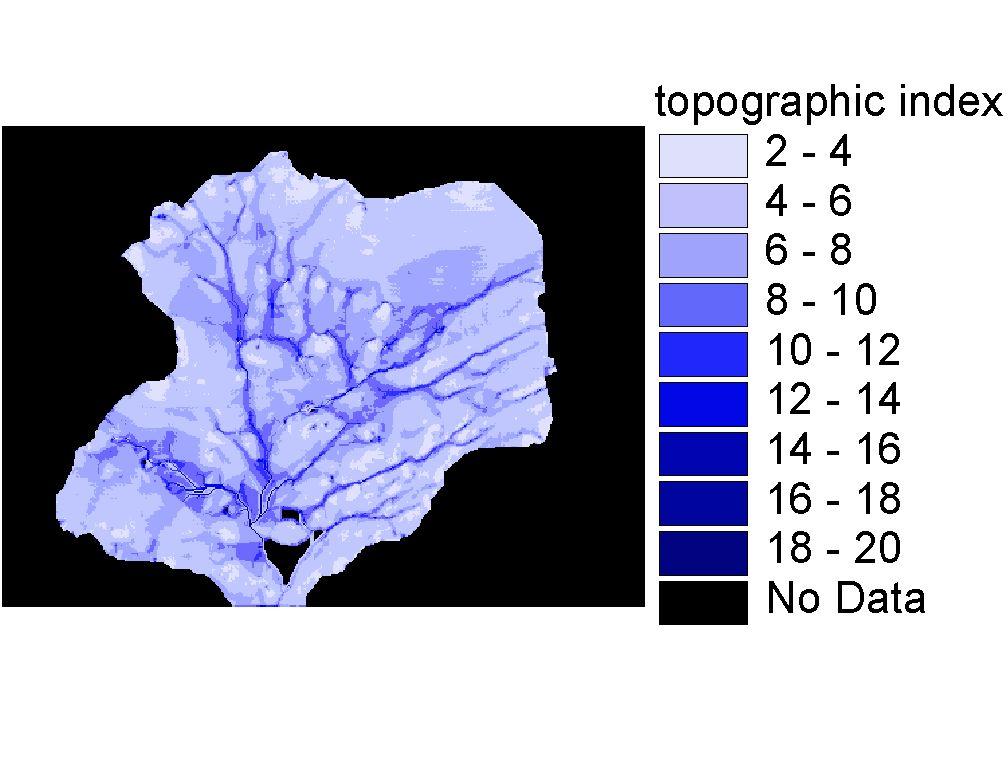
40

41

42 Average Annual Runoff

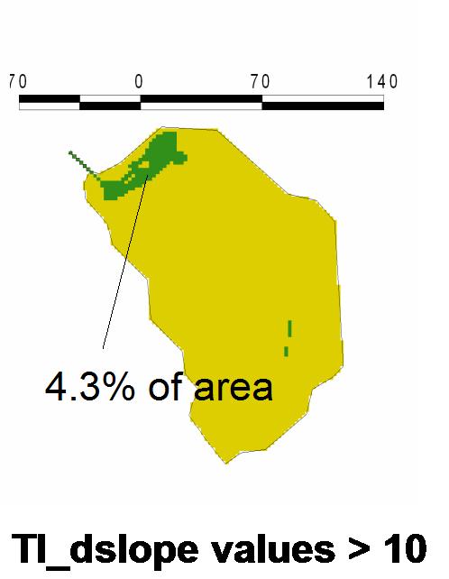
43 Variable Source Area Concept Conceptualized by Hewlett and Hibbert 1967 in US Cappus 1960 in France Tsukamoto 1961 in Japan when shallow groundwater intersects the soil surface the areal extent of intersection determines saturation over land flow and return flow the extent of intersection varies with moisture and amount of groundwater

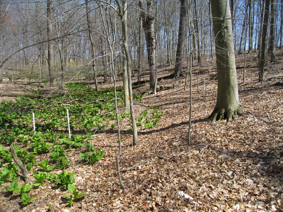
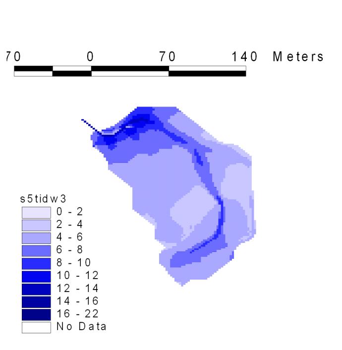
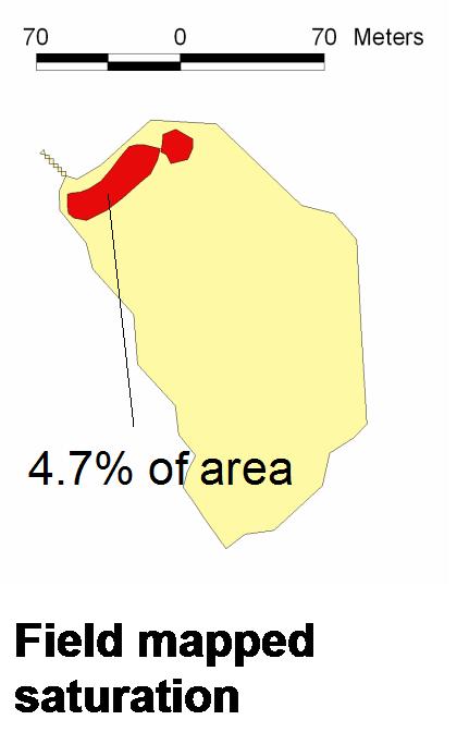
44 The areal extent of the near-stream saturated area characterized as the variable source area Variable - because the areal extent changes depending on the wetness of the catchment.
45 T 2 T 1 Rain VSA at T2 VSA at T1 Storm-event expansion & contraction The variable source area concept (VSA) dynamic spatial extent

46 Role of topography in VSA hydrology Surface topography controls Convergence/divergence Anderson and Burt, 1978 topographic hollows were key hotspots for runoff generation Work of Troch et al., 2009 Convergent slopes because of storage at the bottom yielded bell shaped runoff hydrographs Divergent slopes displayed peaked response


47 So, what are the key factors that determine the wetness at a point? - Valley bottom wetness in Point Peter Brook watershed role of VSA dynamics
48 Topographic Index Based on the Variable Source Area Concept! -- A catchment scale representation Potential for saturation at a point in the watershed or hillslope dependent on Contributing area a determines the runoff volume at a point Local slope that determines the ability to move that runoff volume through the soil
49 Potential for wetness characterized by - ln (a/tanb) a contributing upslope area; B local slope angle under uniform recharge, steady state conditions - high a more runoff low a less runoff high tanb higher hydraulic gradient less backup of water low tan B lower hydraulic gradient greater backup of water high ln(a/tanb) more wetness -- values 9 16 low ln(a/tanb) less wetness or drier areas values 2-5 upper slope areas low ln(a/tanb); near stream areas high ln(a/tanb). Topographic index computations can be performed using program Needed DEM (preferably 3m or less)
50

51 tidwi No Data


52 Comparing Topographic index derived saturation potential against actual wetness in the catchment Comparisons for Point Peter Brook (Inamdar et al., 2004) Valley-bottom wetland in the catchment
53
54 Value of Topographic Index maps Hydrologic Biogeochemical moisture and wetness a driver of many biogeochemical processes! Why topographic indices do not match field observed wetness?
55 Bedrock topography controls Soil moisture distribution and catchment wetness may not necessarily be determined by surface topography in all catchments especially the case in mild or moderate slopes. Soil thickness, bedrock features may come into play! Bedrock not impermeable in most cases Bedrock permeability can influence hillslope drainage and the length of the recession curve. Exfiltration and downslope leakage of water from bedrock may also be an important factor Bedrock topography may be an important control during medium to large storms During small storms the soil depth may have greater controls.

56 Jim Freer paper and work --
57

58 Regional Groundwater & Runoff
59 Key Challenges in Hydrology: Characterizing spatial and temporal variability, unified theory, and catchment classification Non-linearity and thresholds Scale issues measurements and modeling Water age measurements and modeling
60 Non linearity, Threshold responses, and Hydrologic connectivity Recent work by Tromp-van Meerveld and McDonnell, 2006 Spence, 2010 Zehe and Sivapalan, 2009 Key examples Isolated hydrologic patches and their connection Isolated moisture patches can form due to Variations in surface and bedrock topography Filling of depressions in surface and bedrock before runoff begins Spatially variable precipitation input concentrated inputs due to throughfall, stemflow, preferential flow paths Differences in soil depth and porosity

61 Fill and spill hypothesis runoff will be low when patches of saturation/water accumulation are hydrologically isolated Sudden increase in runoff as isolated patches are connected hydrologically! A non-linear threshold response.

62 Patches of wetness could form due to various reasons

63 Changes with catchment scale Proportion of landscape units Response of runoff and its components
Definitions 3/16/2010. GG22A: GEOSPHERE & HYDROSPHERE Hydrology
 GG22A: GEOSPHERE & HYDROSPHERE Hydrology Definitions Streamflow volume of water in a river passing a defined point over a specific time period = VxA discharge m 3 s -1 Runoff excess precipitation - precipitation
Hydrologic cycle, runoff process
 Hydrologic cycle, runoff process Motivation of hydrological modelling What happens at the catchment and in the stream when it rains? How does the increased/decreased runoff affect (not only) the landowners
BAEN 673 / February 18, 2016 Hydrologic Processes
 BAEN 673 / February 18, 2016 Hydrologic Processes Assignment: HW#7 Next class lecture in AEPM 104 Today s topics SWAT exercise #2 The SWAT model review paper Hydrologic processes The Hydrologic Processes
Chapter 3 Physical Factors Affecting Runoff
 Chapter 3 Physical Factors Affecting Runoff Copyright 2003 David G Tarboton, Utah State University CHAPTER 3: PHYSICAL FACTORS AFFECTING RUNOFF The general climatic regime controls the total volume of
Introduction. Welcome to the Belgium Study Abroad Program. Courses:
 Introduction Welcome to the Belgium Study Abroad Program Courses: AGSM 335: Soil and Water Management BAEN 460: Principals of Environmental Hydrology BAEN 460 / AGSM 335 Combined lecture and HW sessions
M.L. Kavvas, Z. Q. Chen, M. Anderson, L. Liang, N. Ohara Hydrologic Research Laboratory, Civil and Environmental Engineering, UC Davis
 Assessment of the Restoration Activities on Water Balance and Water Quality at Last Chance Creek Watershed Using Watershed Environmental Hydrology (WEHY) Model M.L. Kavvas, Z. Q. Chen, M. Anderson, L.
Lecture 11: Water Flow; Soils and the Hydrologic Cycle
 Lecture 11: Water Flow; Soils and the Hydrologic Cycle Water Flow in Soils Types of Water Flow in Soil Saturated flow: Soil pores completely filled with water; controlled by the hydrostatic potential After
M.L. Kavvas, Z. Q. Chen, M. Anderson, L. Liang, N. Ohara Hydrologic Research Laboratory, Civil and Environmental Engineering, UC Davis
 Assessment of the Restoration Activities on Water Balance and Water Quality at Last Chance Creek Watershed Using Watershed Environmental Hydrology (WEHY) Model M.L. Kavvas, Z. Q. Chen, M. Anderson, L.
SOIL AND THE HYDROLOGIC CYCLE
 GEOLOGY 408/508 SOIL AND THE HYDROLOGIC CYCLE CHAPTER 6 Brady & Weil, Rev. 14th ed. THE HYDROLOGIC CYCLE (FIGURE 6.2) WATER BALANCE EQUATION Watershed - an area of land drained by a single stream system
Water Budget IV: Soil Water Processes P = Q + ET + G + ΔS
 Water Budget IV: Soil Water Processes P = Q + ET + G + ΔS Infiltration Infiltration capacity: The maximum rate at which water can enter soil. Infiltration capacity curve: A graph showing the time-variation
NREM 407/507 WATERSHED MANAGEMENT Day 2
 NREM 407/507 WATERSHED MANAGEMENT 1-15-09 - Day 2 1. Review Hydrologic Cycle Terminology/Model 2. Summarize Differences Cropfield vs Perennial Watershed 3. Tues Lab Develop International River PPT bring
EFFECTS OF WATERSHED TOPOGRAPHY, SOILS, LAND USE, AND CLIMATE ON BASEFLOW HYDROLOGY IN HUMID REGIONS: A REVIEW
 PROGRESS IN PHYSICAL GEOGRAPHY EFFECTS OF WATERSHED TOPOGRAPHY, SOILS, LAND USE, AND CLIMATE ON BASEFLOW HYDROLOGY IN HUMID REGIONS: A REVIEW KATIE PRICE 2011 Presented by: Jordan Martin Article Overview
Runoff Processes. Daene C. McKinney
 CE 374 K Hydrology Runoff Processes Daene C. McKinney Watershed Watershed Area draining to a stream Streamflow generated by water entering surface channels Affected by Physical, vegetative, and climatic
Soil Processes: SVAT, ET, and the Subsurface. Summary
 Soil Processes: SVAT, ET, and the Subsurface CIVE 781: Principles of Hydrologic Modelling University of Waterloo Jun 19 24, 2017 Summary The role of soil and vegetation in the water cycle Soil Physics:
SNAMP water research. Topics covered
 SNAMP water research SNAMP water team UC Merced Topics covered Objectives, goals & overview What & why the water component of SNAMP Pre-treatment Observations Water Quality Water Quantity Modeling & Scenarios:
The Hydrological Cycle. Hydrological Cycle. Definition of Terms. Soils and Water, Spring Lecture 7, The Hydrological Cycle 1
 The Hydrological Cycle Water vapor helps warm up the earth Evaporation+Transpiration Chemical Spill Runoff To Oceans Water potential, atmosphere Hydrological Cycle Transpiration, T Atmospheric pool Interception
Hydrology and Water Management. Dr. Mujahid Khan, UET Peshawar
 Hydrology and Water Management Dr. Mujahid Khan, UET Peshawar Course Outline Hydrologic Cycle and its Processes Water Balance Approach Estimation and Analysis of Precipitation Data Infiltration and Runoff
Effect of Land Surface on Runoff Generation
 Effect of Land Surface on Runoff Generation Context: Hydrologic Cycle Runoff vs Infiltration Infiltration: Process by which water on the ground surface enters the soil Runoff: Water (from rain, snowmelt,
Salt Dynamics in prairie wetlands under changing climate
 Salt Dynamics in prairie wetlands under changing climate Uri Nachshon Andrew Ireson Garth van der Kamp Howard Wheater Ryan Davies GIWS, University of Saskatchewan GIWS, University of Saskatchewan Environment
Hydrologic Modeling with the Distributed-Hydrology- Soils- Vegetation Model (DHSVM)
") Hydrologic Modeling with the Distributed-Hydrology- Soils- Vegetation Model (DHSVM) DHSVM was developed by researchers at the University of Washington and the Pacific Northwest National Lab 200 Simulated
Hydrologic Modeling with the Distributed-Hydrology- Soils- Vegetation Model (DHSVM) DHSVM was developed by researchers at the University of Washington and the Pacific Northwest National Lab 200 Simulated
CEE6400 Physical Hydrology
 CEE6400 Physical Hydrology Midterm Review Learning Objectives (what you should be able to do) Hydrologic data, the hydrologic cycle and water balance (HW 1) Work with hydrologic data, quantify uncertainty
Watersheds and the Hydrologic Cycle
 Watersheds and the Hydrologic Cycle The Global Hydrologic Cycle Water Cycle in Florida Florida Water Facts Surface Area = 170,452 km 2 Average Rainfall = 140 cm (55 ) Total Annual Rain = 238 billion m
The Texas A&M University and U.S. Bureau of Reclamation Hydrologic Modeling Inventory (HMI) Questionnaire
 Questionnaire") The Texas A&M University and U.S. Bureau of Reclamation Hydrologic Modeling Inventory (HMI) Questionnaire May 4, 2010 Name of Model, Date, Version Number Dynamic Watershed Simulation Model (DWSM) 2002
The Texas A&M University and U.S. Bureau of Reclamation Hydrologic Modeling Inventory (HMI) Questionnaire May 4, 2010 Name of Model, Date, Version Number Dynamic Watershed Simulation Model (DWSM) 2002
Factors affecting evaporation 3/16/2010. GG22A: GEOSPHERE & HYDROSPHERE Hydrology. Several factors affect the rate of evaporation from surfaces:
 GG22A: GEOSPHERE & HYDROSPHERE Hydrology Some definitions Evaporation conversion of a liquid to a vapour Transpiration that part of evaporation which enters the atmosphere through plants Total Evaporation
Hydrologic Cycle. Water Availabilty. Surface Water. Groundwater
 Hydrologic Cycle Hydrologic ydoogccyce cycle Surface Water Groundwater Water Availabilty 1 Hydrologic Cycle Constant movement of water above, on, and, below the earth s surface (Heath) Endless circulation
East Maui Watershed Partnership Adapted from Utah State University and University of Wisconsin Ground Water Project Ages 7 th -Adult
 INTRODUCTION What is groundwater? Water contained in saturated soil and rock materials below the surface of the earth. It is not NEW water, but is recycled water through the hydraulic cycle. The source
NREM 407/507 WATERSHED MANAGEMENT
 NREM 407/507 WATERSHED MANAGEMENT Please pick up Syllabus, Reading Material & Today s Lab on the Table in the Front Dick Schultz Instructor Sara Berges Teaching Assistant January 13, 2009 1. Conduct Get
An Overview of JULES. Christina Bakopoulou
 An Overview of JULES Christina Bakopoulou JULES, MOSES AND TRIFFID JULES (Joint UK Land Environment Simulator) is a new land surface model Joint initiative: NERC through the CEH, CLASSIC, QUEST and the
The Islamic University of Gaza- Civil Engineering Department Sanitary Engineering- ECIV 4325 L5. Storm water Management
 The Islamic University of Gaza- Civil Engineering Department Sanitary Engineering- ECIV 4325 L5. Storm water Management Husam Al-Najar Storm water management : Collection System Design principles The Objectives
Vegetation Management and Water Yield: Silver Bullet or a Pipe Dream?
 Vegetation Management and Water Yield: Silver Bullet or a Pipe Dream? Lee H. MacDonald rofessor Emeritus and Senior Research Scientist Watershed Science/NREL Colorado State University, Fort Collins, CO
Working with the Water Balance
 Working with the Water Balance Forest Hydrology and Land Use Change Paul K. Barten, Ph.D. Professor of Forestry and Hydrology Department of Environmental Conservation www.forest-to-faucet.org The Living
Hydrologic Modeling Overview
 Hydrologic Modeling Overview Chuck Downer, PhD, PE Hydrologic Systems Branch Coastal and Hydraulics Laboratory Engineer Research and Development Center Vicksburg, Mississippi Hydrologic processes Hydrologic
Ch 18. Hydrologic Cycle and streams. Tom Bean
 Ch 18. Hydrologic Cycle and streams Tom Bean Wednesday s outline 1. the hydrologic cycle reservoirs cycling between them Evaporation and the atmosphere 2. Surface hydrology infiltration and soil moisture
Understanding Earth Fifth Edition
 Understanding Earth Fifth Edition Grotzinger Jordan Press Siever Chapter 17: THE HYDROLOGIC CYCLE AND GROUNDWATER Lecturer: H Mohammadzadeh Assistant professors, Department of Geology, FUM Copyright 2007
CHAPTER 13 OUTLINE The Hydrologic Cycle and Groundwater. Hydrologic cycle. Hydrologic cycle cont.
 CHAPTER 13 OUTLINE The Hydrologic Cycle and Groundwater Does not contain complete lecture notes. To be used to help organize lecture notes and home/test studies. Hydrologic cycle The hydrologic cycle is
Runoff and soil loss. (Quantification and modeling of watershed discharge and sediment yield) Kassa Tadele (Dr.Ing) Arba Minch University
 Kassa Tadele (Dr.Ing) Arba Minch University") Runoff and soil loss (Quantification and modeling of watershed discharge and sediment yield) Kassa Tadele (Dr.Ing) Arba Minch University Part I. Runoff Contents 1. Fundamental Concepts 2. Generation of
Runoff and soil loss (Quantification and modeling of watershed discharge and sediment yield) Kassa Tadele (Dr.Ing) Arba Minch University Part I. Runoff Contents 1. Fundamental Concepts 2. Generation of
Physiographic zones. and water quality
 Southland Physiographic zones Central Plains Technical information Physiographic zones are part of the Water and Land 2020 & Beyond project that aims to maintain and improve water quality in the Southland
Issue paper: Aquifer Water Balance
 Issue paper: Aquifer Water Balance 1. Introduction And Background 1.1. Purpose and Scope The population in Kitsap County has grown rapidly in recent years and is expected to increase substantially in the
Biogeochemistry of Wetlands: Wetland hydrology
 Institute of Food and Agricultural Sciences (IFAS) Wetland hydrology, transport processes, and modeling June 23-26, 2008 Gainesville, Florida Wetland Biogeochemistry Laboratory Soil and Water Science Department
Unit 2: Weather Dynamics Chapter 1: Hydrological Cycle
 UNIT 2 Chapter 1: Inquiring about Weather Unit 2: Weather Dynamics Chapter 1: Hydrological Cycle Science 10 Mrs. Purba Importance of H 2 O From the beginning of time when water first appeared, it has been
CHAPTER FIVE Runoff. Engineering Hydrology (ECIV 4323) Instructors: Dr. Yunes Mogheir Dr. Ramadan Al Khatib. Overland flow interflow
 Instructors: Dr. Yunes Mogheir Dr. Ramadan Al Khatib. Overland flow interflow") Engineering Hydrology (ECIV 4323) CHAPTER FIVE Runoff Instructors: Dr. Yunes Mogheir Dr. Ramadan Al Khatib Overland flow interflow Base flow Saturated overland flow ١ ٢ 5.1 Introduction To Runoff Runoff
Engineering Hydrology (ECIV 4323) CHAPTER FIVE Runoff Instructors: Dr. Yunes Mogheir Dr. Ramadan Al Khatib Overland flow interflow Base flow Saturated overland flow ١ ٢ 5.1 Introduction To Runoff Runoff
Watershed Characterization, Monitoring and Measurements
 Watershed Characterization, Monitoring and Measurements Intent - highlight key approaches to watershed monitoring using the Fair Hill Study watershed as an example Watershed characterization and monitoring
URBAN FLOODING: HEC-HMS
 1.0 Introduction URBAN FLOODING: HEC-HMS -Sunil Kumar, Director, NWA All major ancient civilisations were developed in the river valleys because river served as source of water, food, transportation and
Application of a Basin Scale Hydrological Model for Characterizing flow and Drought Trend
 Application of a Basin Scale Hydrological Model for Characterizing flow and Drought Trend 20 July 2012 International SWAT conference, Delhi INDIA TIPAPORN HOMDEE 1 Ph.D candidate Prof. KOBKIAT PONGPUT
Pennsylvania Stormwater Best Management Practices Manual. Chapter 3. Stormwater Management Principles and Recommended Control Guidelines
 Pennsylvania Stormwater Best Management Practices Manual Chapter 3 Stormwater Management Principles and Recommended Control Guidelines 363-0300-002 / December 30, 2006 Chapter 3 Stormwater Management Principles
2
 1 2 3 4 5 6 The program is designed for surface water hydrology simulation. It includes components for representing precipitation, evaporation, and snowmelt; the atmospheric conditions over a watershed.
SOIL DEVELOPMENT AND PROPERTIES / Water Storage and Movement 1253
 SOIL DEVELOPMENT AND PROPERTIES / Water Storage and Movement 1253 concentrations and exhibit more rapid growth than trees grown on adjacent sites without irrigation. Summary 1. The concept of land treatment
Simple toolbox for worldwide topography based soils reclassification for initialization of SWAT
 Simple toolbox for worldwide topography based soils reclassification for initialization of SWAT Daniel R. Fuka, Charlotte MacAlister, Solomon Seyoum, Todd Walter, Zachary Easton Cornell University IWMI
Afternoon Lecture Outline. Northern Prairie Hydrology
 Afternoon Lecture Outline 1. Northern Prairies watershed hydrology 2. Solute mass balance in lakes and ponds 3. Simple mass balance simulation using MS Excel 4. Effects of sediment-water exchange on lake
Quantifying effects of catchments storage thresholds on step changes in the flood frequency curve
 WATER RESOURCES RESEARCH, VOL. 49, 6946 6958, doi:10.1002/wrcr.20553, 2013 Quantifying effects of catchments storage thresholds on step changes in the flood frequency curve Magdalena Rogger, 1 Alberto
WATER AND THE HYDROLOGIC CYCLE
 WATER AND THE HYDROLOGIC CYCLE Summary Water is essential for the support of life and can be considered as a fundamental environmental good. Water is needed to support human habitation, grow crops and
1.6 Influence of Human Activities and Land use Changes on Hydrologic Cycle
 1.6 Influence of Human Activities and Land use Changes on Hydrologic Cycle Watersheds are subjected to many types of changes, major or minor, for various reasons. Some of these are natural changes and
Theories of Hydrological Connectivity. Mike Kirkby Geography, U. Leeds
 Theories of Hydrological Connectivity Mike Kirkby Geography, U. Leeds Summary Structural and Functional connectivity Definitions etc Structural connectivity Connectivity for continuous and discrete systems
EART 204. Water. Dr. Slawek Tulaczyk. Earth Sciences, UCSC
 EART 204 Water Dr. Slawek Tulaczyk Earth Sciences, UCSC 1 Water is an amazing liquid, (high heat capacity - particularly in phase transitions, maximum density at ca. 4 deg. C) 2 3 4 5 6 7 8 9 Basin Hydrologic
AN INTEGRATED GROUNDWATER RECHARGE AND FLOW MODEL TO PREDICT BASE FLOW
 AN INTEGRATED GROUNDWATER RECHARGE AND FLOW MODEL TO PREDICT BASE FLOW By XIAOJING NI A THESIS Submitted to Michigan State University in partial fulfillment of the requirements for the degree of Civil
Lecture 1: Hydrologic cycle
 1-1 GEOG415 Lecture 1: Hydrologic cycle Hydrologic cycle is ultimately driven by solar radiation, which evaporates water from the ocean and lift it up in the atmosphere. Dunne & Leopold, 1978, Fig. 1-1
Slope Stabilisation modelling in the island tropics. Prof. Malcolm G Anderson PhD DSc CEng FICE A.M.ASCE
 Slope Stabilisation modelling in the island tropics Prof. Malcolm G Anderson PhD DSc CEng FICE A.M.ASCE Landslide risk analysis is an interdisciplinary problem but Governments forced to act on as need
Urbanization effects on the hydrology of the Atlanta area, Georgia (USA)
") 14/06/01 Impact of Human Activity on Groundwater Dynamics (Proceedings of a symposium held during the Sixth IAHS Scientific Assembly at Maastricht, The Netherlands, July 2001). IAHS Publ. no. 269, 2001.
14/06/01 Impact of Human Activity on Groundwater Dynamics (Proceedings of a symposium held during the Sixth IAHS Scientific Assembly at Maastricht, The Netherlands, July 2001). IAHS Publ. no. 269, 2001.
Hydrology 101. Impacts of the Urban Environment. Nokomis Knolls Pond Summer June 2008
 Hydrology 101 Nokomis Knolls Pond Summer 2002 Impacts of the Urban Environment Hydrologic Cycle; What is it? Geography, Topography, Geology, Land Cover and Climate determine the Amount and Behavior of
Comparison of Green-Ampt and Curve Number Infiltration Methods in a single-gauged Brazilian watershed
 Comparison of Green-Ampt and Curve Number Infiltration Methods in a single-gauged Brazilian watershed Julio Issao Kuwajima Toulouse, 2013 Introduction The volume and rate of runoff of rain events are of
Afternoon Lecture Outline
 Afternoon Lecture Outline 1. Northern Prairies watershed hydrology 2. Solute mass balance in lakes and ponds 3. Simple mass balance simulation using MS Excel 4. Effects of sediment-water exchange on lake
DRAINAGE & DESIGN OF DRAINAGE SYSTEM
 Drainage on Highways DRAINAGE & DESIGN OF DRAINAGE SYSTEM P. R.D. Fernando Chartered Engineer B.Sc.(Hons), M.Eng. C.Eng., MIE(SL) Drainage Requirement of Highway Drainage System Introduction Drainage means
Lecture 9A: Drainage Basins
 GEOG415 Lecture 9A: Drainage Basins 9-1 Drainage basin (watershed, catchment) -Drains surfacewater to a common outlet Drainage divide - how is it defined? Scale effects? - Represents a hydrologic cycle
UNIT HYDROGRAPH AND EFFECTIVE RAINFALL S INFLUENCE OVER THE STORM RUNOFF HYDROGRAPH
 UNIT HYDROGRAPH AND EFFECTIVE RAINFALL S INFLUENCE OVER THE STORM RUNOFF HYDROGRAPH INTRODUCTION Water is a common chemical substance essential for the existence of life and exhibits many notable and unique
Managing trees to reduce stormwater: i Tree Hydro can help
 Managing trees to reduce stormwater: i Tree Hydro can help Photo by Gary Simpson Catherine Deininger, Biocenosis LLC cdeininger@biocenosis.org www.biocenosis.org Roadmap 1. Trees as Green Infrastructure
Of vital importance..
 Soil moisture Of vital importance.. Low and erratic rainfall form a significant cause of low crop production and crop failure in rainfed agriculture in the tropics However, crop and land management do
Module 2: Basic Stormwater Principles
 Module 2: Basic Stormwater Principles 2a. Overview... 2 Inspectors and stormwater management...2 Definition of stormwater runoff...3 VSMP technical criteria...3 Environmental Site Design...4 Best management
6.0 Runoff. 6.1 Introduction. 6.2 Flood Control Design Runoff
 October 2003, Revised February 2005 Chapter 6.0, Runoff Page 1 6.1 Introduction 6.0 Runoff The timing, peak rates of discharge, and volume of stormwater runoff are the primary considerations in the design
Chapter 2: Aquifers and groundwater
 Chapter 2: Aquifers and groundwater Groundwater movement through aquifers is driven by differences in groundwater levels or pressure and is controlled by how porous the material is that it passes through.
Lecture 20: Groundwater Introduction
 Lecture 20: Groundwater Introduction Key Questions for Groundwater 1. What is an aquifer? 2. What is an unconfined aquifer? 3. What is groundwater recharge? 4. What is porosity? What determines the magnitude
Continuous Simulation Modeling of Stormwater Ponds, Lakes, & Wetlands: A BUILT-IN APPLICATION OF PONDS 3.2
 Continuous Simulation Modeling of Stormwater Ponds, Lakes, & Wetlands: A BUILT-IN APPLICATION OF PONDS 3.2 PRESENTED AT THE SFWMD WORKSHOP PRE-DEVELOPMENT VERSUS POST DEVELOPMENT RUNOFF VOLUME ANALYSIS
Watershed Hydrology and Water Resources Science Teacher Education Program (STEP)
") Watershed Hydrology and Water Resources Science Teacher Education Program (STEP) Presented by Amy Tidwell Water and Environmental Research Center/ Institute of Northern Engineering University of Alaska
Watershed Hydrology and Water Resources Science Teacher Education Program (STEP) Presented by Amy Tidwell Water and Environmental Research Center/ Institute of Northern Engineering University of Alaska
Power function decay of hydraulic conductivity for a TOPMODEL-based infiltration routine
 HYDROLOGICAL PROCESSES Hydrol. Process. 20, 3825 3834 (2006) Published online 16 May 2006 in Wiley InterScience (www.interscience.wiley.com). DOI: 10.1002/hyp.6159 Power function decay of hydraulic conductivity
Event and Continuous Hydrological Modeling with HEC- HMS: A Review Study
 Event and Continuous Hydrological Modeling with HEC- HMS: A Review Study Sonu Duhan *, Mohit Kumar # * M.E (Water Resources Engineering) Civil Engineering Student, PEC University Of Technology, Chandigarh,
Page 1. Name:
 Name: 7574-1 - Page 1 1) The diagram below shows the result of leaving an empty, dry clay flowerpot in a full container of water for a period of time. The water level in the container dropped to level
2
 1 2 3 4 5 Context Our basin has diverse landscapes from the forested Cascade Mountains, the agricultural Willamette Valley, to the densely populated cities of Eugene, Salem, and Portland. Water flows through
Water Balance Methodology
 Water Balance Methodology Integrating the Site with the Watershed and the Stream March 2012 An initiative under the umbrella of the Water Sustainability Action Plan for British Columbia Water Balance Methodology
July, International SWAT Conference & Workshops
 Analysis of the impact of water conservation measures on the hydrological response of a medium-sized watershed July, 212 212 International SWAT Conference & Workshops ANALYSIS OF THE IMPACT OF WATER CONSERVATION
GLY 155 Introduction to Physical Geology, W. Altermann. Grotzinger Jordan. Understanding Earth. Sixth Edition
 Grotzinger Jordan Understanding Earth Sixth Edition Chapter 17: THE HYDROLOGIC CYCLE AND GROUNDWATER 2011 by W. H. Freeman and Company Chapter 17 The Hydrologic Cycle and Groundwater 1 About the Hydrologic
New techniques for stabilizing, amending and revegetating mine waste
 New techniques for stabilizing, amending and revegetating mine waste Including soil regeneration, erosion resistance and revegetation treatments in mined land remediation designs Vic Claassen Soils and
1. Stream Network. The most common approach to quantitatively describing stream networks was postulated by Strahler (1952).
.") 1. Stream Network The most common approach to quantitatively describing stream networks was postulated by Strahler (1952). First Order Streams streams with no tributaries. Second Order Streams begin at
1. Stream Network The most common approach to quantitatively describing stream networks was postulated by Strahler (1952). First Order Streams streams with no tributaries. Second Order Streams begin at
TECHNICAL BULLETIN. Synthetic Turf Athletic Field Drainage Design Assistance
 TECHNICAL BULLETIN Synthetic Turf Athletic Field Drainage Design Assistance The SportsEdge HQ geocomposite strip drain products are engineered specifically for use in synthetic turf athletic field base
Hydrologic Analysis Techniques ( 87 Manual Hydrology Tools )
") Hydrologic Analysis Techniques ( 87 Manual Hydrology Tools ) Objectives Know which wetland applies to which technique Define the Wetland Water Budget Locate data Understand the time step Understand Limitations
Hydrologic Analysis Techniques ( 87 Manual Hydrology Tools ) Objectives Know which wetland applies to which technique Define the Wetland Water Budget Locate data Understand the time step Understand Limitations
API SOIL & GROUNDWATER RESEARCH BULLETIN
 American API SOIL & GROUNDWATER RESEARCH BULLETIN A summary of research results from API s Soil and Groundwater Technical Task Force. No. 2 March 1997 Estimation of Infiltration and Recharge for Environmental
CEE3430 Engineering Hydrology
 CEE3430 Engineering Hydrology Practice Exam (There are multiple practice questions here A 110 min test will likely not have more than four questions) 1. Water Balance Write the water balance as Δ Where
Stormwater Management Standards for Pennsylvania. Another. A presentation from The Other Side of the Table
 Stormwater Management Standards for Pennsylvania Another A presentation from The Other Side of the Table What we ve been taught: Watershed Hydrologic Process Actual infiltration and watershed runoff processes
GY 111 Lecture Note Series Groundwater and Hydrogeology
 GY 111 Lecture Notes D. Haywick (2008-09) 1 GY 111 Lecture Note Series Groundwater and Hydrogeology Lecture Goals A) The hydrologic cycle B) Groundwater dynamics C) Mapping groundwater (done in class not
Measuring discharge. Climatological and hydrological field work
 Measuring discharge Climatological and hydrological field work 1. Background Discharge (or surface runoff Q s) refers to the horizontal water flow occurring at the surface in rivers and streams. It does
Journal of Hydrology
 Journal of Hydrology 4 (211) 133 143 Contents lists available at ScienceDirect Journal of Hydrology journal homepage: www.elsevier.com/locate/jhydrol Long-term water balance and conceptual model of a semi-arid
Potential effects evaluation of dewatering an underground mine on surface water and groundwater located in a rural area
 Potential effects evaluation of dewatering an underground mine on surface water and groundwater located in a rural area ITRODUCTIO Michel Mailloux* Eng. M.Sc, Vincent Boisvert, M.Sc, Denis Millette, Eng.,
M. Tech Irrigation & Drainage Engineering
 M. Tech Irrigation & Drainage Engineering Basic Supporting Courses S. No. Course Code Course Title L-T-P Credits 1. MAS 701 Advanced Engineering Mathematics 3-1-0 4 2. MAS 711 Statistics I 2-0-1 3 3. COMP
L-THIA Online and LID in a watershed investigation
 L-THIA Online and LID in a watershed investigation Larry Theller Agricultural and Biological Engineering, Purdue University Great Lakes Sedimentation Workshop Ann Arbor Mi. L-THIA On-line watershed delineation
Seasonal rainfall runoff relationships in a lowland forested watershed in the southeastern USA
 University of Nebraska - Lincoln DigitalCommons@University of Nebraska - Lincoln USDA Forest Service / UNL Faculty Publications U.S. Department of Agriculture: Forest Service -- National Agroforestry Center
Learning objectives. Upon successful completion of this lecture, the participants will be able to:
 Solomon Seyoum Learning objectives Upon successful completion of this lecture, the participants will be able to: Describe and perform the required step for designing sewer system networks Outline Design
CAEP Study Site: Cannonsville Reservoir Watershed
 Tammo Steenhuis, Zach Easton, Eric White, C. Shoemaker Joshua Woodbury and many others of the Soil and Water Laboratory, Farming Community and the Watershed Agriculture Program in Walton This project is
The potential to influence runoff processes by changes in land use
 The potential to influence runoff processes by changes in land use M. Weiler, S. Scherrer, C. Thoma, P. Fackel and F. Naef Abstract. Different runoff processes like Hortonian overland flow (HOF), saturation
Water Resources on PEI: an overview and brief discussion of challenges
 Water Resources on PEI: an overview and brief discussion of challenges Components: Components and links Atmospheric water Surface water (including glacial water) Groundwater Links: Precipitation (atm(
Comparison of Recharge Estimation Methods Used in Minnesota
 Comparison of Recharge Estimation Methods Used in Minnesota by Geoffrey Delin, Richard Healy, David Lorenz, and John Nimmo Minnesota Ground Water Association Spring Conference Methods for Solving Complex
Freshwater. 260 Points Total
 9 SURFACE WATER SECTION 9.1 Surface Water Movement In your textbook, read about surface water and the way in which it moves sediment. Complete each statement. (13 points) 1. An excessive amount of water
Lecture 19. Landfill hydrology
 Lecture 19 Landfill hydrology Landfill hydrology Water Pathways Rainfall/Snowfall Transpiration Snow Evaporation Interception Interception Evaporation Runoff Snow Melt Snow Accumulation Plant Growth Infiltration