HYDROLOGY STUDY LA MIRADA BOULEVARD La Mirada, California
|
|
|
- Shonda Walters
- 6 years ago
- Views:
Transcription
1 HYDROLOGY STUDY LA MIRADA BOULEVARD La Mirada, California TTM Prepared for: The Olson Company 3010 Old Ranch Parkway, Suite 100 Seal Beach, CA Contact: Mr. Aaron Orenstein (562) Property: La Mirada Boulevard La Mirada, California APN: Prepared by: C&V Consulting, Inc Burbank Foothill Ranch, California (949) Contact: Mr. Ryan Bittner, P.E. & Mr. Gerardo Garduno, Project Manager March 2015
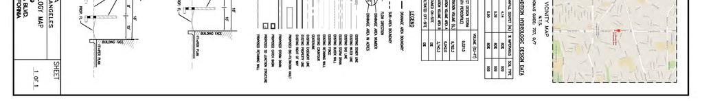
2 TABLE OF CONTENTS I. Acknowledgement and Signature Page...1 II. Introduction & Methodology Site Location Map...2 III. Design Criteria IV. Conclusion..4 V. References.. 5 Supporting Calculations Existing Condition Area A: 10-Year Storm Event...7 Existing Condition Area A: 25-Year Storm Event...8 Proposed Condition Area A: 10-Year Storm Event...9 Proposed Condition Area A: 25-Year Storm Event...10 Proposed Condition Area B: 10-Year Storm Event...11 Proposed Condition Area B: 25-Year Storm Event...12 Proposed Condition Area A: 85 th Percentile, 24-hr Storm...13 Proposed Condition Area B: 85 th Percentile, 24-hr Storm...14 Street Capacity Analysis...15 Exhibits Year 24 Hour Isohyet Map 1-H1.20 Showing Site Location 2. Hydrology Map (1) Existing Development 3. Hydrology Map (1) Proposed Development
3 HYDROLOGY STUDY La Mirada Boulevard C&V Consulting, Inc. Hydrology Study For La Mirada Boulevard and Granada Avenue La Mirada, California TTM ACKNOWLEDGEMENT AND SIGNATURE PAGE This Hydrology Study has been prepared by C&V Consulting, Inc. under the supervision of Ryan Bittner, P.E. Ryan Bittner, P.E. C&V Consulting, Inc Date 1
(F) Single Family Residential with two overlay districts, (A) Farm Animal and (F) Flood Hazard.")
4 HYDROLOGY STUDY La Mirada Boulevard C&V Consulting, Inc. Introduction / Methodology: The project site consists of approximately 2.72 acres of generally flat land which is currently zoned R (A)(F) Single Family Residential with two overlay districts, (A) Farm Animal and (F) Flood Hazard. The project site falls under the Low Density Residential category of the City of La Mirada s General Plan Land Use Policy Map, Figure LU-2 which allows for a maximum density of 6.0 units per acre. We propose the development of 33 residential condominiums, a density of 12.1 homes per acre. Through entitlement, a zone change and general plan amendment will be processed. The subject project is located at La Mirada Boulevard, in the City of La Mirada. North of the project site is the Imperial Convalescent Hospital. La Mirada Boulevard borders the site on the west. There are Single-Family Residential homes which border the site to the east and south. Figure 1 Site Location Map 2
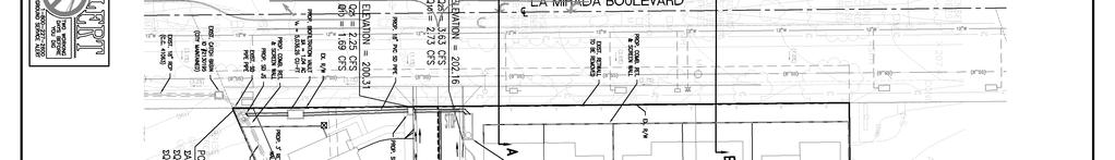
5 HYDROLOGY STUDY La Mirada Boulevard C&V Consulting, Inc. Pre-Development Condition: Under the existing condition, the onsite runoff generally sheet flows in a south and southwesterly direction towards La Mirada Boulevard, then south along La Mirada Boulevard into an existing off site catch basin which diverts the runoff to the existing storm drain infrastructure in La Mirada Boulevard. The existing 27 RCP storm drain system in La Mirada Boulevard is owned and maintained by the City of La Mirada. Ultimately, runoff entering this storm drain system within La Mirada Boulevard is discharged into Milan Creek which connects to Coyote Creek- North Fork, then converges with Coyote Creek which connects to the San Gabriel River Reach 1 (Estuary to Firestone) then the San Gabriel River Estuary prior to discharging to the Pacific Ocean. Currently the site consists of a two-story building (the La Mirada Friends Christian Pre-School) on the west side and a one story building, temporary building and shed on the east portion of the site. The remainder of the site contains parking areas, drive aisles, landscaped areas and playground facilities. Access can be made from La Mirada Boulevard. The existing site is approximately 57% impervious surface. The site is projected to have 80% impervious surface. Proposed Condition: The proposed development will consist of 33 condominium units consisting of 18 buildings and associated improvements (internal roadways, walkway and landscaping). Overall, the site is estimated to be 80% impervious. The onsite runoff will flow towards the curb and gutter located on each side of the main drive aisle. The flow will be conveyed in a southwesterly direction towards the two on-site catch basins which will connect to the existing storm drain system in La Mirada Boulevard. Based on a site visit and the plans provided by the City of La Mirada, there is an existing catch basin located south of the southwest corner of the project site that connects to an existing 18 Reinforced Concrete Pipe (RCP) storm drain main within La Mirada Boulevard. The 18 RCP main flows south in La Mirada Boulevard and connects to an existing 27 RCP storm drain main. Additionally, per plan P.C. 3658, provided by the Los Angeles Department of Public Works (LACDPW), there is an existing 6 storm drain easement that is located south of the southerly property line. For water quality treatment requirements two Biofiltration Systems are proposed to intercept the first 0.9 of rainfall, the 85 th percentile 24-hr storm event. A Standard Urban Stormwater Mitigation Plan (SUSMP) has been prepared according to the City of La Mirada standards to address water quality calculations. 3
6 HYDROLOGY STUDY La Mirada Boulevard C&V Consulting, Inc. Design Criteria: 1. According to the Los Angeles County Department of Public Works Hydrology Manual 50- Year 24-Hour Isohyet Map 1-H1.10, the drainage area is located in Soil Group 009, the site receives 5.8 inches of rainfall over a 24-Hr storm (Q 50 ). 2. The LACDPW Time of Concentration Calculator Program was used to determine the Tc, run-off flow, run-off volume for site, and the first 0.9 run-off from site (85 th Percentile 24- hr Isohyet). 3. The site was analyzed for a 10 & 25-year storm event per the requirements of the January 2006 Los Angeles County Department of Public Works Hydrology Manual. A Rational Method Analysis was performed and the appropriate calculations are provided herein. 4. The drainage areas for the proposed development were determined based on the proposed street/land flow areas and the existing offsite topography. Based on the available information, off-site flows to the project are not anticipated at this time. 5. The length of the flow path used to calculate the time of concentration was the longest runoff distance to the point of discharge for that sub area. 6. The slope of the flow path used to calculate the time of concentration was determined based on the total elevation change across that flow path per the proposed grades. 7. The percent impervious area for the existing condition was calculated based on the existing topographic map and photos from the site. 8. The percent impervious area for the proposed condition was calculated based on the proposed site plan. 9. The Hydrology Map attached to this study is made part of this study. 10. The rainfall frequency multiplication factors used to estimate peak runoff for additional storm events were taken from Table of LACDPW Hydrology Manual. Conclusions: The results from this hydrology and hydraulic analysis demonstrate the following: The drainage design for this site meets or exceeds the level of urban flood protection as described in the Los Angeles County Department of Public Works Hydrology Manual. The estimated 10-year, 24-hour peak flow of the proposed development is 4.42 cfs. The estimated 25-year, 24-hour peak flow of the proposed development is 5.88 cfs. 4
7 HYDROLOGY STUDY La Mirada Boulevard C&V Consulting, Inc. Flow rates increased, approximately 3.5% in the proposed conditions due to an increase in impervious area in the proposed condition. Existing Flow Rates (cfs) 10 Yr Storm Event 25 Yr Storm Event Area A Total Proposed Area A Area B Total Existing & Proposed Impervious vs. Pervious Table Size % % Size Impervious Pervious Pre-Development 1.56 ac 57% 1.16 ac 43% Post-Development 2.18 ac 80% 0.54 ac 20% Refer to the Exhibit 2 and 3 for Existing and Proposed Hydrology Maps in this report for information pertaining to land use and imperviousness coverage. Regarding design capture volume and post-development water quality information, refer to separately prepared SUSMP report by C&V Consulting, Inc. dated March 2015 for additional information. REFERENCES 1. Los Angeles County Department of Public Works, Hydrology Manual, January Los Angeles County Department of Public Works, Tc Calculator Excel Spreadsheet. 3. Hydraflow Express Extensions for Civil 3D Preliminary Grading Plan for this project by C&V consulting. 5
8 HYDROLOGY STUDY La Mirada Boulevard C&V Consulting, Inc. Supporting Calculations 6

9 C&V Consulting, Inc. Hydrology Calculation Sheet Existing Condition Area A 10-Year Storm Event 7
10 C&V Consulting, Inc. Hydrology Calculation Sheet Existing Condition Area A 25-Year Storm Event 8
11 C&V Consulting, Inc. Hydrology Calculation Sheet Proposed Condition Area A 10-Year Storm Event 9
12 C&V Consulting, Inc. Hydrology Calculation Sheet Proposed Condition Area A 25-Year Storm Event 10
13 C&V Consulting, Inc. Hydrology Calculation Sheet Proposed Condition Area B 10-Year Storm Event 11
14 C&V Consulting, Inc. Hydrology Calculation Sheet Proposed Condition Area B 25-Year Storm Event 12

15 C&V Consulting, Inc. Hydrology Calculation Sheet Proposed Condition Area A Volume for first 0.9 inch run-off 85 th Percentile 24-hr Isohyet ( 13
16 C&V Consulting, Inc. Hydrology Calculation Sheet Proposed Condition Area B Volume for first 0.9 inch run-off 85 th Percentile 24-hr Isohyet ( 14
17 C&V Consulting, Inc. Hydraulic Calculation Sheet Street Flow: Analysis was performed to inspect the surface flow capacity of the proposed internal roadway before flooding would occur outside of the roadway improvement. The following calculation depicts the water surface elevation conveying the 25-year storm event along the typical street section. A flow rate of 5.88 was used in this calculation consistent with the largest flow rate being conveyed within the site. 15
18 Exhibits

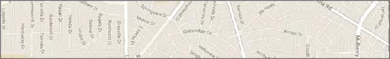
19 Exhibit 1 50-Year 24 Hour Isohyet Map 1-H1.20 Showing Site Location
20 Exhibit 2 Hydrology Map (1) Existing Development
21
22 Exhibit 3 Hydrology Map (1) Proposed Development
23
PRELIMINARY DRAINAGE STUDY
 PRELIMINARY DRAINAGE STUDY For 34 th & J Residences 3402 J St. San Diego, CA 92102 A.P.N 545-250-08 Prepared By: Kenneth J. Discenza, P.E. Site Design Associates, Inc. 1016 Broadway, Suite A El Cajon,
PRELIMINARY HYDROLOGY STUDY
 PRELIMINARY HYDROLOGY STUDY FOR Tentative Tract Map West Side of Loma Alta Drive City of Oceanside, CA Prepared For: EMERALD HILLS LLC 4272 Dogwood Avenue Seal Beach, CA 90740 Contact: Mr. Jimmy Chen Ph:
Appendix G Preliminary Hydrology Study
 Appendix G Preliminary Hydrology Study Preliminary Hydrology Study VESTING TTM 72608 Long Beach, CA Prepared for: The Long Beach Project, LLC 888 San Clemente, Suite 100 New Port Beach, CA May 28, 2014
Appendix E.2 Preliminary Hydrology Report
 Appendix E.2 Preliminary Hydrology Report PRELIMINARY HYDROLOGY STUDY HARVARD WESTLAKE SCHOOL PARKING STRUCTURE 3700 Coldwater Canyon North Hollywood, CA 91604 KPFF Job # 109046 August 12, 2013 CLIENT:
City Plaza Residential (TPM ) Preliminary Hydrology Report
 Preliminary Hydrology Report") Hydrology Study City Plaza Residential (TPM 2016-127) Preliminary Hydrology Report Orange, Orange County, California Prepared For: Greenlaw Partners 18301 Von Karman Avenue, Suite 250 Irvine, CA 92612
Hydrology Study City Plaza Residential (TPM 2016-127) Preliminary Hydrology Report Orange, Orange County, California Prepared For: Greenlaw Partners 18301 Von Karman Avenue, Suite 250 Irvine, CA 92612
Preliminary Stormwater Quality Mitigation Report
 Preliminary Stormwater Quality Mitigation Report MGA Chatsworth Campus 20000 Prairie Street Chatsworth, CA TUSTIN 17782 17th Street Suite 200 Tustin, CA 92780-1947 714.665.4500 Fax 714.665.4501 LOS ANGELES
G. HYDROLOGY Existing Conditions
 G. HYDROLOGY Existing Conditions Surface Water Runoff This section is based on the hydrology and drainage analysis for the proposed Project, which was prepared by KPFF Consulting Engineers and is attached
Hydrology Study. Ascension Heights Subdivision Ascension Drive at Bel Aire Road San Mateo, California (Unincorporated)
") Hydrology Study Ascension Heights Subdivision Ascension Drive at Bel Aire Road San Mateo, California (Unincorporated) Prepared for San Mateo Real Estate & Construction March 9, 21 Rev. 1 11-8-211 Rev.
Hydrology Study Ascension Heights Subdivision Ascension Drive at Bel Aire Road San Mateo, California (Unincorporated) Prepared for San Mateo Real Estate & Construction March 9, 21 Rev. 1 11-8-211 Rev.
Capturing Storm Water in Semi-arid Climate
 Capturing Storm Water in Semi-arid Climate REBEKA SULTANA, PHD CALIFORNIA STATE UNIVERSITY, LONG BEACH NATHANIEL SUMMERVILLE, PE CALIFORNIA STATE UNIVERSITY LONG BEACH (STUDENT PROJECT MANAGER) AND CH2M
Appendix L. Drainage Report
 Appendix L Drainage Report 2nd Street and Pacific Coast Highway Retail Project City of Long Beach County of Los Angeles, CA DRAINAGE REPORT April 5, 2017 DRAINAGE REPORT For: 2nd Street and Pacific Coast
IV. ENVIRONMENTAL IMPACT ANALYSIS G. HYDROLOGY/WATER QUALITY
 IV. ENVIRONMENTAL IMPACT ANALYSIS G. HYDROLOGY/WATER QUALITY ENVIRONMENTAL SETTING The project site is located in the Wilshire community of the City of Los Angeles and is bound by S. Wetherly Drive to
Preliminary Drainage Analysis
 Preliminary Drainage Analysis Tanimura and Antle Employee Housing Town of Spreckels County of Monterey, California LIB150205 May 29, 2015 Prepared For: Tanimura and Antle Produce Prepared By: 9699 Blue
Appendix B. Storm Drain System Data
 MENIFEE VALLEY CAMPUS MASTER PLAN FINAL EIR MT. SAN JACINTO COMMUNITY COLLEGE DISTRICT Appendix Appendix B. Storm Drain System Data June 2017 MENIFEE VALLEY CAMPUS MASTER PLAN FINAL EIR MT. SAN JACINTO
Appendix H Amanda Estates Drainage Study
 Appendix H Amanda Estates Drainage Study Hunsaker & Associates 2015 Contents 1 Scope... 1 2 Existing Conditions... 1 3 Project Description... 3 4 Methodology... 5 4.1 Hydrology... 5 4.2 Hydraulics...
Subject: Mt. San Antonio College- Measure RR Updated Hydrology Study
 To: Cc: Mike Klein Mt. San Antonio College Sidney Lindmark, AICP Mt SAC Environmental Consultant From: Alysen Weiland, PE - Psomas Date: May 6, 2016 Subject: Mt. San Antonio College- Measure RR Updated
HYDROLOGY STUDY PREPARED FOR: MARKHAM PERRIS LLC 302 WEST FIFTH STREET, SUITE 103 SAN PEDRO, CA (310) FOR THE PROJECT:
 FOR THE PROJECT:") HYDROLOGY STUDY PREPARED FOR: MARKHAM PERRIS LLC 302 WEST FIFTH STREET, SUITE 103 SAN PEDRO, CA 90731 (310) 241-2992 FOR THE PROJECT: PERRIS VALLEY COMMERCE CENTER BUILDING PERRIS, CALIFORNIA PROJECT NUMBER:
HYDROLOGY STUDY PREPARED FOR: MARKHAM PERRIS LLC 302 WEST FIFTH STREET, SUITE 103 SAN PEDRO, CA 90731 (310) 241-2992 FOR THE PROJECT: PERRIS VALLEY COMMERCE CENTER BUILDING PERRIS, CALIFORNIA PROJECT NUMBER:
CORBIN AND NORDHOFF IV. ENVIRONMENTAL IMPACT ANALYSIS ENV EIR F. HYDROLOGY
 F. HYDROLOGY ENVIRONMENTAL SETTING Project Site The Project Site is located at 19601 Nordhoff Street in the Chatsworth area of the City of Los Angeles, California, within the Chatsworth - Porter Ranch
PRELIMINARY DRAINAGE REPORT FOR THE EDI MASTER PLAN
 PRELIMINARY DRAINAGE REPORT FOR THE EDI MASTER PLAN April 5, 2015 Wayne W. Chang, MS, PE 46548 Chang Civil Engineering Hydrology Hydraulics Sedimentation P.O. Box 9496 Rancho Santa Fe, CA 92067 (858) 692-0760
DESIGN DEVELOPMENT HYDROLOGY REPORT & LOW IMPACT DEVELOPMENT PLAN (LID PLAN)
") DESIGN DEVELOPMENT HYDROLOGY REPORT & LOW IMPACT DEVELOPMENT PLAN ( PLAN) ALAMITOS BEACH CONCESSION BUILDING 780 E. SHORELINE DRIVE LONG BEACH, CALIFORNIA Prepared For: Long Beach Public Works 333 W. Ocean
DESIGN DEVELOPMENT HYDROLOGY REPORT & LOW IMPACT DEVELOPMENT PLAN ( PLAN) ALAMITOS BEACH CONCESSION BUILDING 780 E. SHORELINE DRIVE LONG BEACH, CALIFORNIA Prepared For: Long Beach Public Works 333 W. Ocean
Stormwater Control Plan for Post Construction Requirements Exhibit 4
 Stormwater Control Plan for Post Construction Requirements Exhibit 4 Application Submittal Where directions state Done that means no additional information or forms below that point needs to be filled
PRELIMINARY DRAINAGE REPORT NEWCASTLE FIRE STATION OLD STATE HIGHWAY
 PRELIMINARY DRAINAGE REPORT FOR THE NEWCASTLE FIRE STATION OLD STATE HIGHWAY PREPARED FOR THE NEWCASTLE FIRE PROTECTION DISTRICT JULY 2014 BY ROSEVILLE DESIGN GROUP, INC. ROSEVILLE DESIGN GROUP, Inc Established
Hydrology Study. For Bella Terrazza Portion of Lot 1, Block 39, Subdivision of S Tract, Rancho El Cajon El Cajon, CA 92021
 Hydrology Study For Bella Terrazza Portion of Lot 1, Block 39, Subdivision of S Tract, Rancho El Cajon El Cajon, CA 92021 Prepared for Daryl Priest - Priest Development Corporation 124 West Main Street,
PART V - STORM DRAIN DESIGN CRITERIA
 PART V - STORM DRAIN DESIGN CRITERIA A. Hydrology Studies and Hydraulic Analyses 1. Drainage area master plans and calculations are to be submitted with all subdivision improvement plans, permit improvement
PART V - STORM DRAIN DESIGN CRITERIA
 PART V - STORM DRAIN DESIGN CRITERIA A. Hydrology Studies and Hydraulic Analyses 1. Drainage area master plans and calculations are to be submitted with all subdivision improvement plans, permit improvement
THE CROSSROADS IN WINCHESTER 4. DRAINAGE PLAN. 4. Drainage Plan. a. Drainage Plan Description
 THE CROSSROADS IN WINCHESTER 4. DRAINAGE PLAN 4. Drainage Plan a. Drainage Plan Description The Specific Plan area drains naturally into two separate watersheds: approximately 6 percent of the Specific
IV. ENVIRONMENTAL IMPACT ANALYSIS D. DRAINAGE AND SURFACE WATER QUALITY
 IV. ENVIRONMENTAL IMPACT ANALYSIS D. DRAINAGE AND SURFACE WATER QUALITY The analysis of drainage impacts included in this section is based on the Storm Drainage Environmental Impact Report prepared by
IV.E. HYDROLOGY AND WATER QUALITY
 IV.E. HYDROLOGY AND WATER QUALITY The following section presents the information provided in the hydrology report prepared by Sukow Engineering. Supporting hydrology data from this report is included in
APPENDIX J-3. Orcem Stormwater Management and Treatment Facilities Design Summary
 APPENDIX J-3 Orcem Stormwater Management and Treatment Facilities Design Summary Stormwater Management & Treatment Facilities Design Summary INTRODUCTION KPFF Consulting Engineers has compiled this report
TABLE OF CONTENTS PART III - MINIMUM DESIGN STANDARDS Section 105 DRAINAGE SYSTEM DESIGN SPECIFICATIONS AND SCOPE 105.1
 TABLE OF CONTENTS PART III - MINIMUM DESIGN STANDARDS Section 105 DRAINAGE SYSTEM DESIGN SECTION TITLE PAGE 105.1. SPECIFICATIONS AND SCOPE 105.1 105.2. METHODS OF ANALYSIS 105.1 105.2.1. Rational Method
INFLOW DESIGN FLOOD CONTROL SYSTEM PLAN PLANT GREENE COUNTY ASH POND ALABMA POWER COMPANY
 INFLOW DESIGN FLOOD CONTROL SYSTEM PLAN PLANT GREENE COUNTY ASH POND ALABMA POWER COMPANY Section 257.82 of EPA s regulations requires the owner or operator of an existing or new CCR surface impoundment
Dawson County Public Works 25 Justice Way, Suite 2232, Dawsonville, GA (706) x 42228
 x 42228") Dawson County Public Works 25 Justice Way, Suite 2232, Dawsonville, GA 30534 (706) 344-3500 x 42228 DAWSON COUNTY STORM WATER REVIEW CHECKLIST Project Name: Property Address: Engineer: Fax #/Email: Date:
Dawson County Public Works 25 Justice Way, Suite 2232, Dawsonville, GA 30534 (706) 344-3500 x 42228 DAWSON COUNTY STORM WATER REVIEW CHECKLIST Project Name: Property Address: Engineer: Fax #/Email: Date:
Activity Calculating Property Drainage
 Page 1 of 5 Activity 2.3.11 Calculating Property Drainage Introduction When a property is developed, it is important to understand that changes to watershed characteristics (i.e., land use, slope, soil
HYDROLOGY CHECKLIST FOR LAND DISTURBANCE PERMITS
 HYDROLOGY CHECKLIST FOR LAND DISTURBANCE PERMITS Project Name: Project Number: Reviewed By: Date: Telephone: Email: Address all items marked with an X Minimum Submittal Requirements 1. Conceptual Review
Introduction to Storm Sewer Design
 A SunCam online continuing education course Introduction to Storm Sewer Design by David F. Carter Introduction Storm sewer systems are vital in collection and conveyance of stormwater from the upstream
HYDROLOGIC-HYDRAULIC STUDY ISABELLA OCEAN RESIDENCES ISLA VERDE, CAROLINA, PR
 HYDROLOGIC-HYDRAULIC STUDY ISABELLA OCEAN RESIDENCES ISLA VERDE, CAROLINA, PR 1 INTRODUCTION 1.1 Project Description and Location Isabella Ocean Residences is a residential development to be constructed
Appendix F HYDROLOGY/WATER QUALITY REPORT TIESLAU CIVIL ENGINEERING
 Appendix F HYDROLOGY/WATER QUALITY REPORT TIESLAU CIVIL ENGINEERING T IE S L A U C I V IL E N G I NE E R IN G, IN C. P.O. B o x 2 2 9 7, K i n g s B ea c h, C A 9 6 1 4 3 p h : (5 3 0 )5 4 6-0 8 6 1 8
PRELIMINARY DRAINAGE STUDY
 PRELIMINARY DRAINAGE STUDY FOR BIG ROCK CLUSTER SOLAR FARMS PREPARED FOR: Daniel Kolta 90FI 8me LLC & 92JT 8me LLC 211 Sutter Street, Fl. 6 San Francisco, CA. 94108 Prepared 5 15 17 Revised 5 26 17 Revised
100-yr Design Runoff (cfs) Basin ID 103b A a B B C Totals
 Basin ID 103b A a B B C Totals") PROPOSED DEVELOPMENT The drainage for this site has been designed to be less than the maximum allowable runoff from each basin as stated in the Overall Rigden Farm drainage plan. Table 1 compares the actual
PROPOSED DEVELOPMENT The drainage for this site has been designed to be less than the maximum allowable runoff from each basin as stated in the Overall Rigden Farm drainage plan. Table 1 compares the actual
FORT COLLINS STORMWATER CRITERIA MANUAL Hydrology Standards (Ch. 5) 1.0 Overview
 1.0 Overview") Chapter 5: Hydrology Standards Contents 1.0 Overview... 1 1.1 Storm Runoff Determination... 1 1.2 Design Storm Frequencies... 1 1.3 Water Quality Storm Provisions... 2 1.4 Design Storm Return Periods...
Chapter 5: Hydrology Standards Contents 1.0 Overview... 1 1.1 Storm Runoff Determination... 1 1.2 Design Storm Frequencies... 1 1.3 Water Quality Storm Provisions... 2 1.4 Design Storm Return Periods...
January 20, Nate Hatleback Project Manager, City of Thornton Development Engineering 9500 Civic Center Drive Thornton, CO (303)
") January 20, 2017 Nate Hatleback Project Manager, City of Thornton Development Engineering 9500 Civic Center Drive Thornton, CO 80229 (303) 538-7694 RE: Riverdale Five Retail Drainage Conformance Letter
January 20, 2017 Nate Hatleback Project Manager, City of Thornton Development Engineering 9500 Civic Center Drive Thornton, CO 80229 (303) 538-7694 RE: Riverdale Five Retail Drainage Conformance Letter
STORM DRAINS AND IRRIGATION
 TABLE OF CONTENTS PART III - MINIMUM DESIGN STANDARDS Section 105 STORM DRAINS AND IRRIGATION 105.1. STORM DRAINS... 105.1 105.2. METHODS OF ANALYSIS... 105.1 105.2.1. Rational Method... 105.1 105.2.2.
Porous Pavements. By Michael Drennan, P.E. Weston Solutions, Inc.
 Porous Pavements By Michael Drennan, P.E. Weston Solutions, Inc. Overview What are porous pavements? Why are they used? Types of porous pavements. Applications of porous pavements and site constraints.
DRAINAGE REPORT. Project Name: PG&E Gas Operations Technical Training Center Winters, CA. Date: February 4, Prepared by: BKF Engineers
 DRAINAGE REPORT Project Name: PG&E Gas Operations Technical Training Center Winters, CA Date: February 4, 2015 Prepared by: BKF Engineers Client: Pacific Gas & Electric Company This report has been prepared
DRAINAGE PLAN AND REPORT OLD DENVER ROAD
 DRAINAGE PLAN AND REPORT 16140 OLD DENVER ROAD PART OF THE NW1/4 SEC. 28, T.11S., R.67W., 6 th P.M. EL PASO COUNTY February 3, 2017 Revised January 5, 2018 Prepared for All About Outdoor Storage Oliver
Stormwater Local Design Manual For Houston County, Georgia
 Stormwater Local Design Manual For Houston County, Georgia Adopted November 15, 2005 TABLE OF CONTENTS 1. FORWARD... 1 2. GENERAL LEVEL OF SERVICE STANDARDS... 2 2.1. DETENTION REQUIREMENTS... 2 2.1.1.
ENGINEERING REVIEW CHECKLIST City of Mount Clemens
 (To be completed by the Developer s & Submitted with ing Plans) DATE: PROJECT NAME: Site Plan Approved: Date DESIGN ENGINEERING COMPANY: ing Company Contact Information: Name: Phone: Email: Owner Contact
12 DRAINAGE General Administrative Requirements Standards
 12 DRAINAGE 12.1 General The Design-Builder shall conduct all Work necessary to meet the requirements associated with drainage, including culverts, bridge hydraulics, roadway ditches, and closed storm
Sump Pumps Office procedures for the Drainage & Grading section
 County of Los Angeles Department of Public Works Building and Safety Division Grading and Drainage Section Sump Pumps Office procedures for the Drainage & Grading section Introduction This manual provides
Rainfall, Runoff and Peak Flows: Calibration of Hydrologic Design Methods for the Kansas City Area
 Rainfall, Runoff and Peak Flows: Calibration of Hydrologic Design Methods for the Kansas City Area Bruce McEnroe, Bryan Young, Ricardo Gamarra and Ryan Pohl Department of Civil, Environmental, and Architectural
Storm Sewers, Page 2
 Storm Sewers storm sewer systems are dendritic systems used to collect and direct stormwater runoff storm sewer systems are integral components of any urban infrastructure curbs, gutters and storm inlets
MODEL Stormwater Local Design Manual. City of Centerville
 MODEL Stormwater Local Design Manual City of Centerville Adopted December 6, 2005 TABLE OF CONTENTS 1. FORWARD... 1 2. GENERAL LEVEL OF SERVICE STANDARDS... 1 2.1. DETENTION REQUIREMENTS... 1 2.1.1. Discharge
APPENDIX H. Draft Storm Drainage Master Plan
 APPENDIX H Draft Storm Drainage Master Plan Folsom Sphere of Influence (SOI) DRAFT Storm Drainage Masterplan Prepared for: MacKay & Somps Civil Engineering, Inc. Prepared By: DOMENICHELLI & ASSOCIATES
RE: Final Drainage Letter: Northwest Aurora Alley Improvements 2016
 April 12, 2016 Mr. Craig Perl, P.E. Senior Engineer City of Aurora Public Works Department 15151 E. Alameda Parkway Aurora, CO 80012 RE: Final Drainage Letter: Northwest Aurora Alley Improvements 2016
RUBONIA SUBDIVISION DRAINAGE AND ROADWAY IMPROVMENTS PREPARED BY: MANATEE COUNTY PUBLIC WORKS ENGINEERING SERVICES DIVISION
 RUBONIA SUBDIVISION DRAINAGE AND ROADWAY IMPROVMENTS PREPARED BY: MANATEE COUNTY PUBLIC WORKS ENGINEERING SERVICES DIVISION OCTOBER 7, 2016 1 INTRODUCTION Rubonia Neighborhood (Rubonia) is located in northern
ATTACHMENT 4 Section Project Status Quarterly Report - Dec 31, 2015 Measure V - Clean Beaches and Ocean Parcel Tax
 ATTACHMENT 4 Section 3.0 - Project Status Quarterly Report - Dec 31, 2015 Completed Projects Description Bicknell Avenue Green Street Pier Storm Drain Improvement Pier Water Quality Improvement Permeable
acquiring, managing, and disposing of federal lands and facilities;
 2.2.1 HYDROLOGY AND FLOODPLAIN This section discusses and analyzes the surface hydrology and water quality characteristics of the project. The information provided in this section is based on the Preliminary
IBS Site Drainage: Senior Design Project
 IBS Site Drainage: Senior Design Project Len Wright, Ph.D., PE Lecturer, CEAE Wright.Len@gmail.com September 11, 2008 mwsw204i1.ppt/1 OUTLINE Motivation for Stormwater Management Quantity (both onsite,
a. Title of Report Example: Final Hydrologic and Hydraulic Drainage Report For Tract #### (or Planning and Zoning Permit ##-###-###)
") CITY OF OXNARD ENGINEERING DIVISION REQUIRED FORMAT AND CONTENTS HYDROLOGIC AND HYDRAULIC DRAINAGE REPORTS This report will provide a basis for design of the drainage system for the subject project. The
CITY OF OXNARD ENGINEERING DIVISION REQUIRED FORMAT AND CONTENTS HYDROLOGIC AND HYDRAULIC DRAINAGE REPORTS This report will provide a basis for design of the drainage system for the subject project. The
Design Handbook. Low Impact Development Best Management Practices
 Design Handbook for Low Impact Development Best Management Practices Prepared by: 9/2011 Riverside County Flood Control and Water Conservation District 1995 Market Street Riverside, CA 92501 TABLE OF CONTENTS
Phase II: Proposed (regulated) Impervious in disturbed area (ac) Long Lake Existing Impervious in disturbed area (ac)
 Impervious in disturbed area (ac) Long Lake Existing Impervious in disturbed area (ac)") Permit Application No.: 17-181 Rules: Erosion Control, Wetland Protection, and Waterbody Crossings & Structures Applicant: Hennepin County Received: 4/27/17 Project: CSAH 112 Phase II Complete: 9/5/17
Permit Application No.: 17-181 Rules: Erosion Control, Wetland Protection, and Waterbody Crossings & Structures Applicant: Hennepin County Received: 4/27/17 Project: CSAH 112 Phase II Complete: 9/5/17
SAN GORGONIO PASS CAMPUS - PHASE I
 SAN GORGONIO PASS CAMPUS - PHASE I Banning, CA DRAINAGE STUDY June 16, 2010 Reference 106-195 PREPARED BY: Encompass Associates, Inc. 5699 Cousins Place Rancho Cucamonga, CA 91737 909-684-0093 Fax-909-586-6979
Example 1: Pond Design in a residential development (Water Quantity calculations for a Wet Pond and Wet Extended Detention Pond)
") Chapter 10 Design Examples Example 1: Pond Design in a residential development (Water Quantity calculations for a Wet Pond and Wet Extended Detention Pond) Example 2: Filter Design in a commercial development
Chapter 10 Design Examples Example 1: Pond Design in a residential development (Water Quantity calculations for a Wet Pond and Wet Extended Detention Pond) Example 2: Filter Design in a commercial development
Home Remodeling Projects
 Should your project require a Standard Urban Stormwater Mitigation Plan (SUSMP), please see the City of Pomona s Standard Urban Stormwater Mitigation Plan (SUSMP) Pamphlet Best Management Practices For
INFLOW DESIGN FLOOD CONTROL SYSTEM PLAN 40 C.F.R. Part PLANT MCINTOSH ASH POND 1 GEORGIA POWER COMPANY
 INFLOW DESIGN FLOOD CONTROL SYSTEM PLAN 40 C.F.R. Part 257.82 PLANT MCINTOSH ASH POND 1 GEORGIA POWER COMPANY EPA s Disposal of Coal Combustion Residuals from Electric Utilities Final Rule (40 C.F.R. Part
SIZING. MWS Linear. Hybrid Stormwater Filtration System. P.O. Box 869 P Oceanside, CA F
 SIZING MWS Linear Hybrid Stormwater Filtration System Modular Wetland Systems, Inc. www.modularwetlands.com P.O. Box 869 P 760-433-7640 Oceanside, CA 92049 F 760-433-3179 SIZING Many municipal stormwater
Chapter 6. Hydrology. 6.0 Introduction. 6.1 Design Rainfall
 6.0 Introduction This chapter summarizes methodology for determining rainfall and runoff information for the design of stormwater management facilities in the City. The methodology is based on the procedures
COUNTY OF LOS ANGELES DEPARTMENT OF PUBLIC WORKS BUILDING AND SAFETY DIVISION - DRAINAGE & GRADING SECTION
 COUNTY OF LOS ANGELES DEPARTMENT OF PUBLIC WORKS BUILDING AND SAFETY DIVISION - DRAINAGE & GRADING SECTION STANDARD URBAN STORMWATER MITIGATION PLAN (SUSMP) REVIEW SHEET Urban and storm water runoff is
INITIAL INFLOW DESIGN FLOOD CONTROL SYSTEM PLAN PLANT MCMANUS ASH POND A (AP-1) 40 CFR
 40 CFR") INITIAL INFLOW DESIGN FLOOD CONTROL SYSTEM PLAN PLANT MCMANUS ASH POND A (AP-1) 40 CFR 257.82 EPA s Disposal of Coal Combustion Residuals from Electric Utilities Final Rule (40 C.F.R. Part 257 and Part
INITIAL INFLOW DESIGN FLOOD CONTROL SYSTEM PLAN PLANT MCMANUS ASH POND A (AP-1) 40 CFR 257.82 EPA s Disposal of Coal Combustion Residuals from Electric Utilities Final Rule (40 C.F.R. Part 257 and Part
STORMWATER MANAGEMENT REPORT FOR. Chick-Fil-A S Ferdon Blvd, Crestview FL. February 10 th, 2017
 STORMWATER MANAGEMENT REPORT FOR Chick-Fil-A 3000 S Ferdon Blvd, Crestview FL February 10 th, 2017 PROJECT #010014-01-047 954.712.7482 www.bowmanconsulting.com Table of Contents Introduction.1 Project
AS A COURTESY, PLEASE TURN OFF CELL PHONES AND PAGERS WHILE MEETING IS IN PROGRESS.
 Table of Contents Agenda 2 Wastewater Treatment Plant (WWTP) Hydraulic Capacity Update Staff Report 3 WWTP Capacity Outline 5 WWTP Capacity Charts 6 Drainage Concerns on Oak Hill Drive and Quail Drive
STORM DRAINAGE DESIGN MANUAL
 Appendix I STORM DRAINAGE DESIGN MANUAL by: SUNGATE DESIGN GROUP, P.A. GEN ERAL DESIGN STAN DARDS AN D POLICIES 1. STREET AND LOCAL DRAINAGE Discharge estimates for specified design storms shall be calculated
Appendix D. Civil Engineering Reports
 Appendix D Civil Engineering Reports JORDAN DOWNS COMMUNITY BASED REDEVELOPMENT BETWEEN GRAPE STREET & SOUTH ALAMEDA STREET BETWEEN EAST 97 TH STREET & EAST 103 RD STREET LOS ANGELES, CA DEVELOPMENT MASTER
4.7 HYDROLOGY AND WATER QUALITY
 4.7 HYDROLOGY AND WATER QUALITY INTRODUCTION The proposed stormwater drainage system for the proposed Via Princessa project would consist of curb and gutters, catch basins, and storm drain culverts crossing
LOW IMPACT DEVELOPMENT ( LID ) STANDARDS
 STANDARDS") LOW IMPACT DEVELOPMENT ( LID ) STANDARDS January 9, 2013 Prepared By Truong Huynh, PE, CBO Superintendent of Building & Safety, Acting OVERVIEW Part I LID Applicability and Requirements Part II Plan Check
LOW IMPACT DEVELOPMENT ( LID ) STANDARDS January 9, 2013 Prepared By Truong Huynh, PE, CBO Superintendent of Building & Safety, Acting OVERVIEW Part I LID Applicability and Requirements Part II Plan Check
LIST OF TABLES... ii LIST OF FIGURES... iii LIST OF APPENDICES... iv. Section 1 - Introduction Purpose of Study... 1
 Preliminary Hydrologic Analysis for Alberhill Villages April 2015 TABLE OF CONTENTS Section Name Page Number LIST OF TABLES... ii LIST OF FIGURES... iii LIST OF APPENDICES... iv Section 1 - Introduction...
3.10 Hydrology and Water Quality. Environmental Setting
 3.10 Hydrology and Water Quality This section describes the potential hydrology and water quality impacts associated with the proposed changes to the approved project. Environmental Setting This section
Report. Inflow Design Flood Control System Plan St. Clair Power Plant St. Clair, Michigan. DTE Energy Company One Energy Plaza, Detroit, MI
 Report Inflow Design Flood Control System Plan St. Clair Power Plant St. Clair, Michigan DTE Energy Company One Energy Plaza, Detroit, MI October 14, 2016 NTH Project No. 62-160047-04 NTH Consultants,
Appendix IS-5. Drainage Study
 Appendix IS-5 Drainage Study Preliminary Drainage Study 100 E. Ocean City of Long Beach Los Angeles County, California Prepared for: American Life, Incorporated 270 S Hanford Street, Suite 200 Seattle,
3.3 Acceptable Downstream Conditions
 iswm TM Criteria Manual - = Not typically used or able to meet design criterion. 1 = The application and performance of proprietary commercial devices and systems must be provided by the manufacturer and
Stormwater Management Impacts Resulting from the Volumetric Abstraction of Runoff from Frequent Storms per PADEP CG-1. Geoffrey A. Cerrelli 1, P.E.
 Stormwater Management Impacts Resulting from the Volumetric Abstraction of Runoff from Frequent Storms per PADEP CG-1 Geoffrey A. Cerrelli 1, P.E. 1 Hydraulic Engineer USDA/NRCS, One Credit Union Place,
3F. Hydrology and Water Quality
 This section provides an analysis of potential hydrological and water quality impacts associated with implementation of the proposed project. The section also evaluates and describes the potential impacts
Chapter 4. Drainage Report and Construction Drawing Submittal Requirements
 4.0 Introduction The requirements presented in this section shall be used to aid the design engineer or applicant in the preparation of drainage reports, drainage studies, and construction drawings for
INFLOW DESIGN FLOOD CONTROL SYSTEM PLAN PLANT BARRY ASH POND ALABAMA POWER COMPANY
 INFLOW DESIGN FLOOD CONTROL SYSTEM PLAN PLANT BARRY ASH POND ALABAMA POWER COMPANY Section 257.82 of EPA s regulations requires the owner or operator of an existing or new CCR surface impoundment or any
E. STORMWATER MANAGEMENT
 E. STORMWATER MANAGEMENT 1. Existing Conditions The Project Site is located within the Lower Hudson Watershed. According to the New York State Department of Environmental Conservation (NYSDEC), Lower Hudson
DRAINAGE PLAN OF NAU S EASTBURN EDUCATION AND GAMMAGE BUILDINGS FINAL PROPOSAL
 MAY 10, 2016 DRAINAGE PLAN OF NAU S EASTBURN EDUCATION AND GAMMAGE BUILDINGS FINAL PROPOSAL Connor Klein, Jiangnan Yi, Yuzhi Zhang, Yi Yang NORTHERN ARIZONA UNIVERSITY NAU Water Buffalo Engineering Table
City of Santa Clarita
 City of Santa Clarita Stormwater Pollution Prevention Fee 2016/2017 ANNUAL FEE REPORT PREPARED ON: APRIL 21, 2016 27368 Via Industria Suite 200 Temecula, CA 92590 T 951.587.3500 800.755.6864 F 951.587.3510
APPENDIX H Guidance for Preparing/Reviewing CEQA Initial Studies and Environmental Impact Reports
 APPENDIX H H.1 Guidance for Preparing and Reviewing CEQA Initial Studies Step 1: Consider the Project Characteristics as Provided by the Project Applicant Review the project application and draft plan
APPENDIX N Guidance for Preparing/Reviewing CEQA Initial Studies and Environmental Impact Reports
 APPENDIX N N.1 Guidance for Preparing and Reviewing CEQA Initial Studies Step 1: Consider the Project Characteristics as Provided by the Project Applicant Review the project application and draft plan
November 21, City of Thornton 9500 Civic Center Drive Thornton, CO (303) RE: Maverik Thornton, CO - Drainage Report
 RE: Maverik Thornton, CO - Drainage Report") November 21, 2016 City of Thornton 9500 Civic Center Drive Thornton, CO 80229 (303) 538-7295 RE: Maverik Thornton, CO - Drainage Report As per your request, we are submitting to you the drainage report
November 21, 2016 City of Thornton 9500 Civic Center Drive Thornton, CO 80229 (303) 538-7295 RE: Maverik Thornton, CO - Drainage Report As per your request, we are submitting to you the drainage report
City of Beverly Hills Low Impact Development (LID) Fact Sheet
 Fact Sheet") On May 18, 2015, the City of Beverly Hills amended its Stormwater and Urban Runoff Pollution Control Ordinance (Article 5 Chapter 4 Title 9 of the Beverly Hills Municipal Code) to include Low Impact Development
On May 18, 2015, the City of Beverly Hills amended its Stormwater and Urban Runoff Pollution Control Ordinance (Article 5 Chapter 4 Title 9 of the Beverly Hills Municipal Code) to include Low Impact Development
APPENDIX F RATIONAL METHOD
 7-F-1 APPENDIX F RATIONAL METHOD 1.0 Introduction One of the most commonly used procedures for calculating peak flows from small drainages less than 200 acres is the Rational Method. This method is most
3.3 FLOOD CONTROL AND HYDROLOGY
 3.3 FLOOD CONTROL AND HYDROLOGY 3.3.1 AFFECTED ENVIRONMENT The sublease boundary is located approximately 0.25-miles north of the San Gabriel River. The San Gabriel River flows from the San Gabriel Mountains
HYDROLOGIC CONSIDERATIONS. 22 nd Annual Nonpoint Source Pollution Conference Saratoga Springs, NY
 LOW IMPACT DEVELOPMENT HYDROLOGIC CONSIDERATIONS 22 nd Annual Nonpoint Source Pollution Conference Saratoga Springs, NY May 18, 2011 PRESENTATION AGENDA Introduction Definitions Discuss Impacts to Hydrologic
1.1 MONITORING PROGRAM OBJECTIVES The major objectives of the Monitoring Program outlined in the Municipal Stormwater Permit are to:
 1.1 MONITORING PROGRAM OBJECTIVES The major objectives of the Monitoring Program outlined in the Municipal Stormwater Permit are to: Assess compliance with the Los Angeles County Municipal Stormwater Permit
Warner Robins Stormwater Local Design Manual
 Warner Robins Stormwater Local Design Manual Prepared for Houston County City of Warner Robins City of Perry City of Centerville May 17, 2005 Version 4 (As presented with adopted Stormwater Ordinance)
Appendix J: The Project Stormwater Control Plan by Lea & Braze Engineering, Inc.
 Appendix J: The Project Stormwater Control Plan by Lea & Braze Engineering, Inc. STORMWATER CONTROL PLAN 23 LOT SUBDIVISION ON PROCTOR ROAD CASTRO VALLEY, CALIFORNIA Owner/Developer: Hue Tran 4584 Ewing
3.3 FLOOD CONTROL AND HYDROLOGY
 3.3 FLOOD CONTROL AND HYDROLOGY 3.3.1 AFFECTED ENVIRONMENT The sublease boundary is located approximately 0.25-miles north of the San Gabriel River. The San Gabriel River flows from the San Gabriel Mountains
County of Los Angeles - Department of Public Works
 GENERAL PROJECT INFORMATION County of Los Angeles - Department of Public Works Building and Safety/Land Development Division LOW IMPACT DEVELOPMENT REVIEW SHEET (2017 Los Angeles County Building Code,
COYOTE CREEK 3 LEVEE SYSTEM LOS ANGELES COUNTY AND ORANGE COUNTY, CALIFORNIA NLD SYSTEM ID #
 LOS ANGELES COUNTY AND ORANGE COUNTY, CALIFORNIA NLD SYSTEM ID # 3805010025 PERIODIC INSPECTION REPORT NO. 2 GENERALIZED EXECUTIVE SUMMARY FINAL SYSTEM RATING: MINIMALLY ACCEPTABLE FINAL RATING DATE: MARCH
DRAFT. Technical Memorandum. Whitney Road Drainage & Safety Enhancements Phase III Hydraulic Update. Prepared For:
 DRAFT Technical Memorandum Whitney Road Drainage & Safety Enhancements Phase III Hydraulic Update Prepared For: Pinellas County Department of Environment and Infrastructure Division of Engineering and