Screening for Appropriate Assessment Proposed residential development at Slievekeale, Waterford City. 13 April 2018
|
|
|
- Gladys Glenn
- 6 years ago
- Views:
Transcription

1 Proposed residential development at City 13 April 2018 NM Ecology Ltd Consultant Ecologists 276 Harold s Grange Road, Dublin 16 Website: info@nmecology.com Tel:
2 Executive Summary This Screening for Appropriate Assessment report has been prepared by NM Ecology Ltd on behalf of Waterford City & County Council (the applicant), as part of a planning application for a residential development at Slievekeale in Waterford City. The proposed development will consist of 58 residential units, with associated internal roads, parking spaces, green areas and services. The proposed development site is within the catchment of the River Suir, of which the main channel and estuary has been designated a Special Area of Conservation. In accordance with their obligations under the European Communities (Birds and Natural Habitats) Regulations 2011 (SI 477/2011), the competent authority must assess whether the proposed development could have likely significant effects on this or any other Natura 2000 sites. This document provides supporting information to assist the competent authority with an Appropriate Assessment screening exercise, including: a description of the proposed development, details of its environmental setting, and a map and list of Natura 2000 sites within the potential zone of impact. Following an assessment of potential impact pathways, we conclude that the proposed development will not cause direct or indirect impacts on any Natura 2000 sites, and thus that Appropriate Assessment is not required. 1
3 1 Introduction 1.1 Background to Appropriate Assessment Approximately 10% of the land area of Ireland is included in the European Network of Natura 2000 sites, which includes Special Protection Areas (SPAs) to protect important areas for birds, and Special Areas of Conservation (SACs) to protect a range of habitats and species. Legislative protection for these sites is provided by the European Council Birds Directive (79/409/EEC) and E.C. Habitats Directive (92/43/EEC, as amended), which are jointly transposed into Irish law by the European Communities (Birds and Natural Habitats) Regulations 2011 (SI 477/2011, as amended). Regulation 42 (1) states that: Screening for Appropriate Assessment of a plan or project for which an application for consent is received [ ] shall be carried out by the public authority to assess, in view of best scientific knowledge and in view of the conservation objectives of the site, if that plan or project, individually or in combination with other plans or projects is likely to have a significant effect on [any Natura 2000 sites]. To ensure compliance with this regulation, planning authorities must screen all planning applications for potential impacts on Natura 2000 sites. Supporting information may be requested from the applicant to assist with this process. This document provides background information to assist the local authority with a Screening for Appropriate Assessment exercise for the proposed development. It includes an outline of the proposed works, details of the environmental setting of the site, an appraisal of future development proposals in the area (potential for in combination effects ), a map and list of Natura 2000 sites within the potential zone of impact, and an assessment of potential impacts. 1.2 Statement of authority This assessment was carried out by Nick Marchant MCIEEM MSc, a qualified and experienced ecologist. He has ten years of professional experience, including seven years as an ecological consultant, one year as a local authority biodiversity officer, and two years managing an NGO overseas. He provides ecological assessments for developments throughout Ireland and Northern Ireland, including wind farms, infrastructural projects (roads, water mains, etc), and a range of commercial and residential developments. He holds an MSc in Ecosystem Conservation and Landscape Management from NUI Galway and a BSc in Environmental Science from Queens University Belfast. He is a member of the Chartered Institute of Ecology and Environmental Management and operates in accordance with their code of professional conduct. 2
4 1.3 Methods This report has been prepared with reference to the following guidelines: Appropriate Assessment of Plans and Projects in Ireland (Department of the Environment, Heritage and Local Government, 2009) Assessment of plans and projects significantly affecting Natura 2000 sites: Methodological guidance on the provisions of Article 6(3) and (4), E.C., 2002 Guidelines for Ecological Impact Assessment in the UK and Ireland: Terrestrial, Freshwater and Coastal (Chartered Institute of Ecology and Environmental Management, 2016) In accordance with Section 3.2 of Appropriate Assessment of Plans and Projects in Ireland, a screening exercise comprises the following steps: 1. Description of the project and local site characteristics 2. Identification of relevant Natura 2000 sites, and compilation of information on their qualifying interests and conservation objectives 3. Assessment of potential impacts upon Natura 2000 sites, including: Direct impacts (e.g. loss of habitat area, fragmentation) Indirect impacts (e.g. disturbance of fauna, pollution of surface water) Cumulative / in combination effects associated with other concurrent projects 4. Screening Statement with conclusions A desk based study was carried out using data from the following sources: Plans and specifications for the proposed development Qualifying interests / conservation objectives of Natura 2000 sites from Bedrock, soil, subsoil, surface water and ground water maps from the Geological Survey of Ireland webmapping service ( the National Biodiversity Data Centre ( and the Environmental Protection Agency web viewer ( The Waterford City Development Plan , and details of permitted or proposed developments from the local authority s online planning records All web based resources were accessed between November 2016 and September
5 2 Description of the Project 2.1 Environmental setting The site is located in the south western suburbs of Waterford City. It consists of unmanaged grasslands, a former basketball court, and some hedgerows / treelines. Based on historical aerial photography of the site (via Google Earth) it appears that it was previously part of the sports fields for the adjacent Presentation Secondary School, but that the boundaries were redrawn at some time between 2005 and Since then, the site has been unmanaged, and it has become overgrown. There is a GAA stadium to the north of the site, schools to the east and south, and housing estates to the west of the site. 2.2 Description of the proposed development The proposed development will consist of 58 residential units. The primary access point will be from Keane s Road on the western boundary, which will lead to paved internal roads and onstreet parking spaces. Landscaped areas will be developed in the centre of the site, and will involve the creation of grassed areas, trees / shrubs, and sports / play facilities. Foul water will be discharged to a local authority foul sewer on Keane s Road, and treated in the municipal waste water treatment plant at Gorteens, Belview, Co. Kilkenny. Surface water runoff from roofs and paved surfaces will be discharged to a storm sewer on Keane s Road. 2.3 Environmental setting Geology and soils The underlying bedrock is dark grey slate with thin siltstone of the Ross Member formation, which is a regionally important aquifer (fissured bedrock). Subsoils are sandstone till, and soils are acid brown earths / brown podzolics, which are deep, well drained soils derived from acidic materials. There are no surface water features (e.g. drainage ditches) on the site, indicating that it has good natural drainage. Hydrology The closest watercourse is the John s River, which is located approx. 620m to the south east of the proposed development site, and discharges to the River Suir estuary approx. 2km to the north east of the site. It is currently of poor status (Water Framework Directive Status Assessments ), but the coastal waters outside the Barrow / Nore estuary are of good status. Considering the distance between the proposed development site and these watercourses, and the lack of intervening drains or streams, it appears that the proposed development site is effectively isolated from the rest of the river catchment. 4
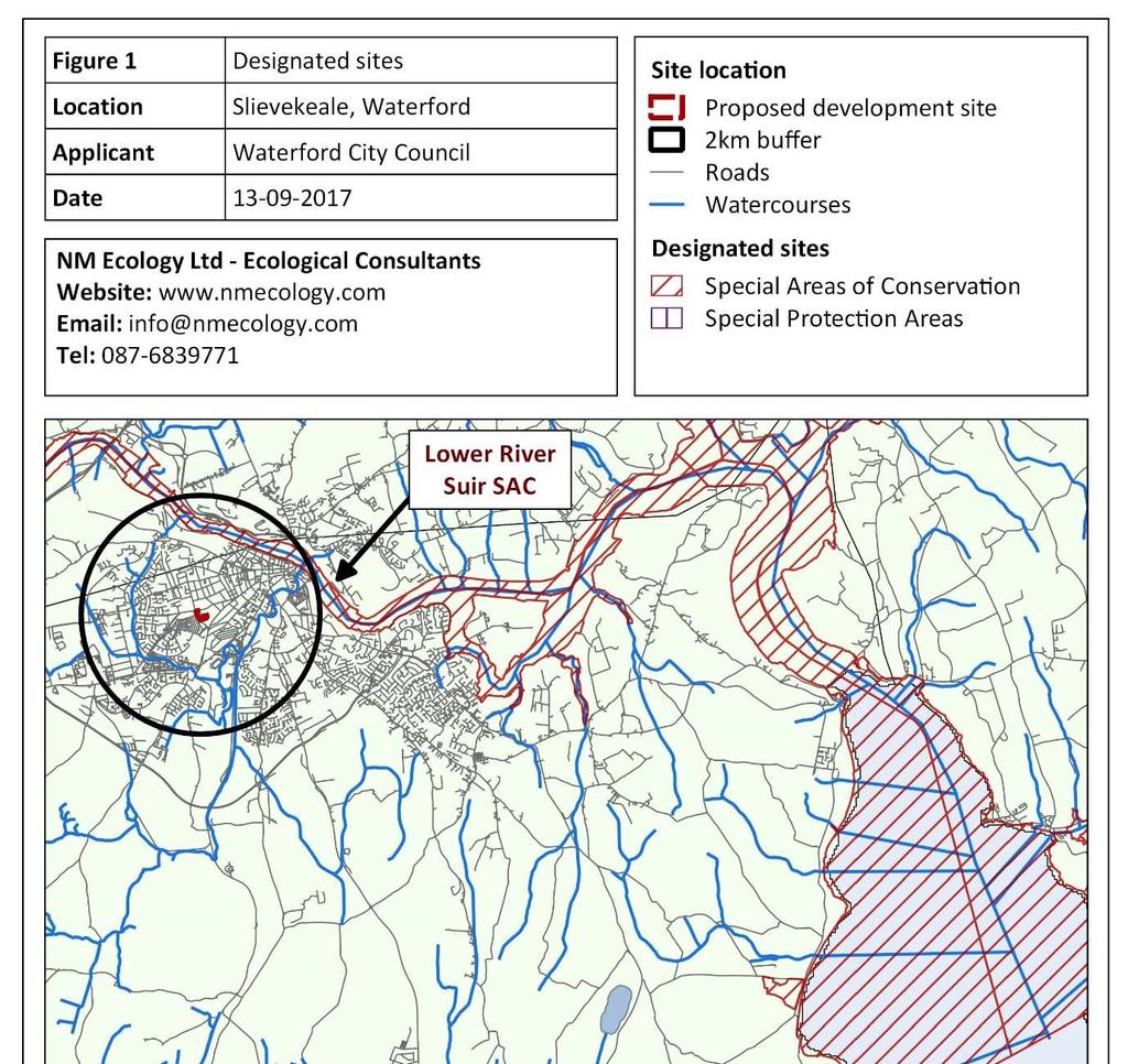
6 2.4 Other nearby developments (potential in combination effects) The proposed development site is located in an urban / suburban setting in the south west of Waterford City. It is included in Zone R2: Existing Residential of the Waterford City Development Plan , for which the planning objective is To protect, provide and improve residential areas and their amenities. Most of the surrounding land is included in the same zone, but there are also some schools and commercial centres that are zoned for community facilities, general business and industrial uses. As the area is already developed, it is unlikely that there will be substantial development pressure over the next 5 10 years, although there may be some small scale re developments or modifications. There are no pending planning applications in the vicinity of the proposed development site (Waterford City Council online planning database), and all other applications within the previous five years have been for small scale works such as residential extensions or signage. No planning applications were identified that could act in combination with the proposed development to increase the scale of potential ecological impacts. 3 Description of Natura 2000 sites 3.1 Identification of Natura 2000 sites within the zone of impact The proposed development site is not located within or adjacent to any Natura 2000 sites, but potential indirect impacts on distant sites were considered within a potential zone of influence of 2km 1. There is one Special Area of Conservation within this distance: details are provided in Table 1, and its location is shown in Figure 1. Table 1: Natura 2000 sites within 5km of the proposed development site Site Name Distance Reasons for designation Lower River Suir SAC (2137) 1.3 km north east Annex I habitats: Atlantic salt meadows, Mediterranean salt meadows, water courses, hydrophilous tall herb fringe communities, old sessile oak woods, alluvial forests, yew woodlands Annex II species: freshwater pearl mussel, white clawed crayfish, sea lamprey, river lamprey, brook lamprey, twaite shad, salmon, otter 1 For the purposes of this assessment we considered indirect impacts on designated sites within a potential zone of influence of 2km. This distance is considered to be proportionate to the relatively small scale of the proposed development, and its urban setting. 5
7 6
8 3.2 Conservation objectives The standard conservation objective for all SACs and SPAs in Ireland is to maintain or restore the favourable conservation condition of the qualifying interests for which the SAC / SPA has been selected. In addition, the Department of Arts, Heritage and the Gaeltacht have produced detailed conservation objectives for the Lower River Suir SAC, which can be viewed on the website of the National Parks and Wildlife Service ( sites), but are not reproduced here in the interests of brevity. 3.3 Identification of potential impact pathways The River Suir is located more than 1km from the proposed development site, and there are no intervening watercourses that could provide a hydrological connection, so are no pathways for direct or indirect impacts on the SAC. 4 Assessment of potential impacts 4.1 Direct impacts The proposed development site is not located within any Natura 2000 sites, so there is no risk of habitat loss, fragmentation or any other direct impacts. 4.2 Indirect impacts Potential changes in water quality (construction phase) Construction works typically generate suspended sediments, and may occasionally result in accidental spills of oil or other toxic chemicals. However, no potential pathways were identified by which these pollutants could reach the Lower River Suir SAC (refer to Section 3.3). Consequently, the risk that pollutants from the construction site could cause significant negative impacts upon the SAC or any other Natura 2000 sites is thought to be negligible, even in a worst case scenario and in the absence of standard site management measures. Potential changes in water quality (operational phase) All foul water from the proposed development will be discharged to a local authority sewer and treated in the municipal waste water treatment plant at Gorteens, Belview, Co. Kilkenny. It is understood that the plant was upgraded in 2010 and that it is currently within capacity and providing adequate treatment before discharge to the River Suir. It is the responsibility of Irish Water to provide appropriate treatment to foul water within public sewers, and the responsibility of the local authority to assess any potential impacts on water quality at the discharge point, typically during the preparation of city / county development plans. 7
9 All surface water runoff from hard surfaces will percolate to ground or will be discharged to a local authority storm sewer. Rainwater that percolates to ground is considered to be free of pollutants and does not pose a risk to local watercourses. Any rainwater discharged to local authority sewers will receive appropriate treatment prior to discharge to receiving waters. Consequently, it can be concluded that foul water and surface water treatment during the operation of the development would not cause any significant impacts upon receiving waters or the SAC. There is no risk of any other ecological impacts during the operation of the proposed development. 4.3 Potential in combination effects As the proposed development will not have any impacts on nearby waterbodies or the SAC, there is no risk of in combination effects with other concurrent developments. 5 Screening Statement Article 42 (7) of the European Communities (Birds and Natural Habitats) Regulations 2011 states that: The public authority shall determine that an Appropriate Assessment of a plan or project is not required [ ] if it can be excluded on the basis of objective scientific information following screening under this Regulation, that the plan or project, individually or in combination with other plans or projects, will have a significant effect on a European site. To assist the planning authorities with the screening exercise, we have provided supporting information including: a description of the proposed development; an outline of its environmental setting; details of Natura 2000 sites within the potential zone of impact; and an assessment of potential impacts. Based on this information, we have demonstrated that there will be no risk of direct or indirect impacts on any Natura 2000 sites, so we conclude that Appropriate Assessment is not required. 8
10 References Chartered Institute of Ecology and Environmental Management, Guidelines for Ecological Impact Assessment in the U.K and Ireland: Terrestrial, Freshwater and Coastal (2nd Edition). C.I.E.E.M., Hampshire, England. Department of the Environment, Heritage and Local Government, Appropriate Assessment of Plans and Projects in Ireland. National Parks and Wildlife Service, DAHG, Dublin, Ireland. European Commission Assessment of plans and projects significantly affecting Natura 2000 sites: Methodological guidance on the provisions of Article 6(3) and (4) of the Habitats Directive 92/43/EEC. Office for Official Publications of the European Communities, Luxembourg. Fossitt, J.A., A Guide to Habitats in Ireland. Heritage Council, Kilkenny 9
1) TO: Dara Lynott, Director
 TO: Dara Lynott, Director") wa *o Environmental A n unhn mrtt vm Protectwn Ckmnm bmhhwr! 0 F F I C I This memo has been cleared for submission to the Director by Programme Marjager, Frank Clinton Signed : cxm:,,
wa *o Environmental A n unhn mrtt vm Protectwn Ckmnm bmhhwr! 0 F F I C I This memo has been cleared for submission to the Director by Programme Marjager, Frank Clinton Signed : cxm:,,
APPROPRIATE ASSESSMENT SCREENING REPORT
 APPROPRIATE ASSESSMENT SCREENING REPORT For the Proposed Increase in Compost Throughput at Existing Miltown Composting Facility ISSUE/REVISION INDEX Revision # Prep. Rev. Date Pages Revised Remarks PA
Appendix A.8.11 A Survey of Selected Rivers for the Galway City Transport Project with Potential for Margaritifera (Moorkens, 2014a)
") Appendix A.8.11 A Survey of Selected Rivers for the Galway City Transport Project with Potential for Margaritifera (Moorkens, 2014a) A.8.11 A SURVEY OF SELECTED RIVERS FOR THE GALWAY CITY TRANSPORT PROJECT
Appendix A.8.11 A Survey of Selected Rivers for the Galway City Transport Project with Potential for Margaritifera (Moorkens, 2014a) A.8.11 A SURVEY OF SELECTED RIVERS FOR THE GALWAY CITY TRANSPORT PROJECT
PROVISION OF INFORMATION REGARDING APPROPRIATE ASSESSMENT SCREENING PROPOSED DEVELOPMENT SOCIAL HOUSING AT ANNE STREET, PROSPEROUS, CO.
 PROVISION OF INFORMATION REGARDING APPROPRIATE ASSESSMENT SCREENING PROPOSED DEVELOPMENT SOCIAL HOUSING AT ANNE STREET, PROSPEROUS, CO. KILDARE PREPARED FOR MCORM ON BEHALF OF KILDARE COUNTY COUNCIL Project
Request for a Technical Amendment to Industrial Emissions licence Register No. P , held by MSD International GMBH, CRO No.
 This report has been cleared for submission by Sean O'Donoghue. Grainne Power, 20/05/2016 09:54 OFFICE OF ENVIRONMENTAL SUSTAINIBILITY To: FROM: C.C: Licensing Programme Memorandum Mr. Dara Lynott, Director
ATTACHMENT E.2 EMISSIONS TO SURFACE WATERS SITE SERVICES LAYOUT SHEET 1 OF 2 (IE DR-0021)
") ATTACHMENT E.2 EMISSIONS TO SURFACE WATERS SITE SERVICES LAYOUT SHEET 1 OF 2 (IE0310818-30-DR-0021) SITE SERVICES LAYOUT SHEET 2 OF 2 (IE0310818-30-DR-0022) LOCATION OF EMISSION TO SURFACE WATER (IE0310818-22-DR-
ATTACHMENT E.2 EMISSIONS TO SURFACE WATERS SITE SERVICES LAYOUT SHEET 1 OF 2 (IE0310818-30-DR-0021) SITE SERVICES LAYOUT SHEET 2 OF 2 (IE0310818-30-DR-0022) LOCATION OF EMISSION TO SURFACE WATER (IE0310818-22-DR-
8 Geology, Hydrology & Hydrogeology
 Inverneill Wind Farm Scoping Report Page 42 8 Geology, Hydrology & Hydrogeology 8.1 Introduction The EIA will consider the potential issues arising from the construction, operation and decommissioning
Habitats Directive Article 6. Appropriate Assessment Screening. Camping Site Policy
 Habitats Directive Article 6 Appropriate Assessment Screening Camping Site Policy Proposed Variation No. 4 to; Waterford County Development Plan 2011-2017 Waterford City Development Plan 2013-2019 Dungarvan
Biodiversity Priorities for Ireland ( ) Andy Bleasdale
 Andy Bleasdale") Biodiversity Priorities for Ireland (2014-20) Andy Bleasdale Outline Introduction Natura 2000 in Ireland EU Biodiversity Strategy to 2020 Article 17 (and Article 12) Prioritised Action Framework for Ireland
Biodiversity Priorities for Ireland (2014-20) Andy Bleasdale Outline Introduction Natura 2000 in Ireland EU Biodiversity Strategy to 2020 Article 17 (and Article 12) Prioritised Action Framework for Ireland
WASTE WATER DISCHARGE LICENCE INSPECTORS REPORT D
 This Report has been cleared for submission to the Board by Dr. Karen Creed, Senior Inspector Signed: 06/08/2013 U D0026-01 Mew (inlbkdl OFFICE OF CLIMATE, LICENSING & 1 RESOURCE USE. WASTE WATER DISCHARGE
APPROPRIATE ASSESSMENT SCREENING REPORT
 APPROPRIATE ASSESSMENT SCREENING REPORT For the Proposed use of an Existing Integrated Constructed Wetland (ICW) at the Miltown Composting Licensed Site (Ref. W0270-01) for the Discharge of Surface Water
Prepared by the National Parks & Wildlife Service of the Department of Arts, Heritage & the Gaeltacht
 MARINE NATURA IMPACT STATEMENTS IN IRISH SPECIAL AREAS OF CONSERVATION A WORKING DOCUMENT APRIL 2012 Prepared by the National Parks & Wildlife Service of the Department of Arts, Heritage & the Gaeltacht
9 Biodiversity. 9.1 Introduction
 9 Biodiversity 9.1 Introduction This chapter provides information on ecological features of particular significance within or adjacent to the site of the Proposed Project, primarily designated habitats
DOCUMENT CONTROL SHEET
 j INFORMATION IN SUPPORT OF AN APPROPRIATE ASSESSMENT OF THE POTENTIAL FOR KILLARNEY DRAFT TOWN PLAN 2009-2015 TO NEGATIVELY IMPACT UPON THE CONSERVATION OBJECTIVES OF NATURA 2000 SITES DOCUMENT CONTROL
Natural Heritage assessment of small scale wind energy projects which do not require formal Environmental Impact Assessment (EIA).
.") Guidance Natural Heritage assessment of small scale wind energy projects which do not require formal Environmental Impact Assessment (EIA). March 2008 Table of Contents Page INTRODUCTION... 2 DEFINITIONS...
Guidance Natural Heritage assessment of small scale wind energy projects which do not require formal Environmental Impact Assessment (EIA). March 2008 Table of Contents Page INTRODUCTION... 2 DEFINITIONS...
IN SUPPORT OF THE APPROPRIATE ASSESSMENT IN ACCORDANCE WITH THE REQUIREMENTS OF ARTICLE 6(3) OF THE EU HABITATS DIRECTIVE
 OF THE EU HABITATS DIRECTIVE") NATURA IMPACT REPORT IN SUPPORT OF THE APPROPRIATE ASSESSMENT OF THE PROPOSED VARIATION NO. 2(B) TO THE GALWAY COUNTY DEVELOPMENT PLAN 2015-2021 IN ACCORDANCE WITH THE REQUIREMENTS OF ARTICLE 6(3) OF THE
NATURA IMPACT REPORT IN SUPPORT OF THE APPROPRIATE ASSESSMENT OF THE PROPOSED VARIATION NO. 2(B) TO THE GALWAY COUNTY DEVELOPMENT PLAN 2015-2021 IN ACCORDANCE WITH THE REQUIREMENTS OF ARTICLE 6(3) OF THE
Habitats Directive Article 6 Assessment. Water Framework Directive River Basin Management Plans and Programmes of Measures North Eastern RBD
 Habitats Directive Article 6 Assessment Nor th Wester n Nea gh B a nn Nor th E a ster n Wester n E a ster n S ha nnon S outh E a ster n S outh Wester n Water Framework Directive River Basin Management
8 Geology, Hydrology, Hydrogeology
 Camster II Wind Farm Scoping Report 50 8 Geology, Hydrology, Hydrogeology 8.1 Introduction The EIA will consider the potential issues arising from the construction, operation and decommissioning of the
6 SUMMARY OF CUMULATIVE AND INDIRECT EFFECTS 6.1 INTRODUCTION
 6 SUMMARY OF CUMULATIVE AND INDIRECT EFFECTS 6.1 INTRODUCTION Cumulative and indirect effects result from the combined impacts of multiple projects / plans. Their consideration is important as the impacts
Refer to Chapter 3.0 (Description of Development) for a detailed site and development description.
 for a detailed site and development description.") 7. WATER: HYDROGEOLOGY & HYDROLOGY 7.1 Introduction This chapter of the EIAR comprises of an assessment of the likely impact of the proposed development on the surrounding surface water and hydrogeological
7. WATER: HYDROGEOLOGY & HYDROLOGY 7.1 Introduction This chapter of the EIAR comprises of an assessment of the likely impact of the proposed development on the surrounding surface water and hydrogeological
determine the effect of the Proposed Development together with the other planned changes within defined areas of influence;
 14 SUMMARY OF CUMULATIVE AND INDIRECT EFFECTS 14.1 INTRODUCTION Cumulative and indirect effects result from the combined impacts of multiple projects / plans. Their consideration is important as the impacts
30 Years of River Quality
 30 Years of River Quality A Retrospective and Prospective View EPA National Water Event Galway Bay Hotel 12-13 June 2013 John Lucey Presentation Outline Overview of past 30 years river quality Problems
How is Water Quality Affected by Land Use?
 Watershed Connections Lesson Les4 3 How is Water Quality Affected by Land Use? Overview What are the benefits of a healthy watershed? What are examples of land uses? What types of pollution can come from
Enclosed farmland: Arable and Horticultural, Improved and Neutral Grasslands
 executive summary Executive summary 1 Countryside Survey 2000 (CS2000) and the Northern Ireland Countryside Survey 2000 (NICS2000) have been designed to provide detailed information about the habitats
Appendix 3.1 Sample Scoping Letter, Newspaper Advertisement and Summary of Responses
 Environmental Impact Statement Appendices for Laois-Kilkenny Reinforcement Project Appendix 3.1 Sample Scoping Letter, Newspaper Advertisement and Summary of Responses SAMPLE SCOPING LETTER Dear Sir/Madam,
The main factors currently affecting rivers and streams in Nottinghamshire are:
 HABITAT ACTION PLAN FOR RIVERS AND STREAMS Nottingham Local Biodiversity Action Plan AUTHOR: LEAD AGENCY: Steve Betts, Environment Agency Environment Agency Trentside Offices Scarrington Road West Bridgford
Water for life and livelihoods
 Water for life and livelihoods Dee River Basin District: Challenges and choices Facts and statistics Background information On 1 April Natural Resources Wales brought together the work of the Countryside
GROUSEMOUNT WIND FARM County Kerry
 GROUSEMOUNT WIND FARM County Kerry ENVIRONMENTAL IMPACT STATEMENT VOLUME 1 - NON-TECHNICAL SUMMARY & EIS TEXT ESB WIND DEVELOPMENT Report No. QR-320171-11-GK0715-R01 ESB WIND DEVELOPMENT LIMITED GROUSEMOUNT
City Development Plan Variation No. 7 Marina Park - Pairc Ui Chaoimh
 City Development Plan Variation No. 7 Marina Park - Pairc Ui Chaoimh Strategic Environmental Assessment (SEA) Screening Report 25 th November 2011 Cork City Council Comhairle Cathrach Chorcaí Proposed
Chapter 8 Natural Resources
 Chapter 8 Natural Resources 127-134 8.1 Introduction 8.2 Extractives Industry 8.3 Forestry 8.4 Fishing / Aquaculture 8.1 Introduction Kerry has a number of naturally occurring resources that contribute
Hydropower Guidance Note: HGN 4 Designated Sites
 Guidance Note Hydropower Guidance Note: HGN 4 Designated Sites This guidance note is not intended as a statement of law. It should be read in combination with, and in the context of, the relevant enactments
Cork County Development Plan Volume Three: SEA Statement and Natura Impact Report
 Cork County Development Plan 2014 Volume Three: SEA Statement and Natura Impact Report 3 Volume 3: SEA Statement and Natura Impact Report Cork County Development Plan 2014 Contents Section 1 Strategic
Irish Water VARTRY WATER SUPPLY UPGRADE PROJECT. EIS Screening Report
 Irish Water VARTRY WATER SUPPLY UPGRADE PROJECT IRISH WATER Vartry Water Supply Upgrade Project Environmental Impact Assessment Screening Report Nicholas O Dwyer Ltd Consulting Engineers Nutgrove Office
APPROPRIATE ASSESSMENT
 APPENDIX 2 APPROPRIATE ASSESSMENT Carrick on Suir Town Council 178 P age Contents 1 Introduction to Habitats Directive and Article 6 Assessment...194 2 Guidance on the implementation of Article 6...195
Bathing Water Profile - Loughshinny Beach (2016)
") Bathing Water Profile - Loughshinny Beach (2016) Bathing Water: Loughshinny Beach Bathing Water Code: IEEABWC020_0000_0400 Local Authority: Fingal County Council River Basin District: Eastern Monitoring
Bathing Water Profile - Loughshinny Beach (2016) Bathing Water: Loughshinny Beach Bathing Water Code: IEEABWC020_0000_0400 Local Authority: Fingal County Council River Basin District: Eastern Monitoring
Birds and Habitats Directives Natura 2000 and Appropriate Assessments
 Workshop on Exemptions under Art. 4(7) of the Water Framework Directive 14/12/2016, Brussels Birds and Habitats Directives Natura 2000 and Appropriate Assessments Fotios Papoulias European Commission,
Draft County Wexford Development Plan Appropriate Assessment Screening Report & Determination
 Draft County Wexford Development Plan 2013-2019 Appropriate Assessment Screening Report & Determination Determination of the need for Appropriate Assessment in accordance with the requirements of Article
25* September 'h February 'h September Ewa Babiarczyk
 ~ I INSPECTOR'S REPORT ON A WASTE WATER DISCHARGE LICENCE APPLICATION To: From: DIRECTORS Ewa Babiarczyk Environmental Licensing Programme Date: 3' December 2009 RE: Application for a Waste Water Discharge
Habitats Directive Article 6 Assessment for Waste Water Discharge License. Downings D
 Habitats Directive Article 6 Assessment for Waste Water Discharge License Downings D0350 01 Executive Summary Article 6 assessments are required under the Habitats Directive (92/43/EEC), and are required
Water Supply Project Eastern and Midlands Region. Appendix F Water Treatment Plant Site Selection
 Water Supply Project Eastern and Midlands Region Appendix F Water Treatment Plant Site Selection Final Options Appraisal Irish Water Water Supply Project, Eastern and Midlands Region Irish Water Final
1. Marine Works (Environmental Impact Assessment) Regulations 2007 (as amended), Regulation 22 - EIA Consent Decision
 Regulations 2007 (as amended), Regulation 22 - EIA Consent Decision") 1. Marine Works (Environmental Impact Assessment) Regulations 2007 (as amended), Regulation 22 - EIA Consent Decision 1.1 Title: Deposit of an underground cable using Horizontal Directional Drill (HDD)
1. Marine Works (Environmental Impact Assessment) Regulations 2007 (as amended), Regulation 22 - EIA Consent Decision 1.1 Title: Deposit of an underground cable using Horizontal Directional Drill (HDD)
Portlaoise Local Area Plan. Natura Impact Report
 16 th March 2018 Document Stage Document Version Date Prepared by Draft 1 19/03/2018 Pat Doherty MSc, MCIEEM This report has been prepared by Minogue & Associates with all reasonable skill, care and diligence.
ENVIRONMENT ACT TERMS OF REFERENCE NOVA SCOTIA DEPARTMENT OF TRANSPORTATION AND PUBLIC WORKS. Beaver Bank Bypass
 ENVIRONMENT ACT TERMS OF REFERENCE NOVA SCOTIA DEPARTMENT OF TRANSPORTATION AND PUBLIC WORKS Beaver Bank Bypass Highway 101 to the Beaver Bank Road Halifax County, NS NOVA SCOTIA DEPARTMENT OF THE ENVIRONMENT
Presentation to Engineers Ireland an Riocht 26 th October, Water Framework Directive River Basin Management Plans ( )
") Presentation to Engineers Ireland an Riocht 26 th October, 2010 Water Framework Directive River Basin Management Plans (2009-2015) Aims of the Presentation To provide some background to the EU Water Framework
Presentation to Engineers Ireland an Riocht 26 th October, 2010 Water Framework Directive River Basin Management Plans (2009-2015) Aims of the Presentation To provide some background to the EU Water Framework
Chapter 10 Natural Environment & Flood Risk Management
 Chapter 10 Natural Environment & Flood Risk Management 10.1 Introduction 10.2 Environmental Designations 10.3 Water Quality 10.4 Septic Tanks and Proprietary Waste Water Treatment Systems 10.5 Features
MEATH COUNTY COUNCIL
 MEATH COUNTY COUNCIL Dunshaughlin Local Area Plan 2009-2015 Strategic Environmental Assessment [incorporating assessment of proposed material amendments to Draft Local Area Plan] Adopted 22nd September
CONCLUSIONS 14 CONTENTS
 CONTENTS Introduction... 14-1 Traffic... 14-1 Air Quality... 14-1 Noise and Vibration... 14-2 Geology and Hydrology... 14-2 Landscape and Visual... 14-3 Ecology... 14-4 Cultural Heritage... 14-4 Population
Strategic Environmental Assessment (SEA) Statement. Mayo County Development Plan
 Statement. Mayo County Development Plan") Strategic Environmental Assessment (SEA) Statement For the Mayo County Development Plan 2014-2020 In accordance with Article 9 of Directive 2001/42/EC of the European Parliament and of the Council on the
Strategic Environmental Assessment (SEA) Statement For the Mayo County Development Plan 2014-2020 In accordance with Article 9 of Directive 2001/42/EC of the European Parliament and of the Council on the
Don Catchment Vision
 Don Catchment Vision Don Catchment Vision A healthy and biodiverse catchment that is valued and enjoyed, contributing to the economic and social well-being of local communities. Aims for the Don To identify
Storm Water Management
 Storm Water Management Policy September 2014 2 Sustainable drainage feature designed to control and manage flows through a series of check dams 3 Document Name: Storm Water Management Controlled Copy No:
Environmental Resource Inventories. What are ERIs? Significance of information How to use them
 Environmental Resource Inventories What are ERIs? Significance of information How to use them Environmental Resource Inventory - ERI Compiled by the environmental commission Information about the natural
ADDENDUM I TO THE APPROPRIATE ASSESSMENT OF THE
 ADDENDUM I TO THE APPROPRIATE ASSESSMENT OF THE DRAFT BRAY MUNICIPAL DISTRICT LOCAL AREA PLAN 2018 2024 APPROPRIATE ASSESSMENT OF THE PROPOSED ALTERATIONS, AS PROPOSED BY THE MEMBERS OF WICKLOW COUNTY
Arcow Quarry, North Yorkshire
 Arcow Quarry, North Yorkshire Non Technical Summary Planning applications for a railhead and associated development REVISION SCHEDULE Rev Date Details Prepared by Reviewed by Approved by 0 December 2013
ORDINANCE APPENDIX C RUNOFF COEFFICIENTS AND CURVE NUMBERS
 ORDINANCE APPENDIX C RUNOFF COEFFICIENTS AND CURVE NUMBERS TABLE C-1. RUNOFF CURVE NUMBERS Source: Table 2-2a, Table 2-2b, and Table 2-2c from U. S. Department of Agriculture, Natural Resources Conservation
CONSTRUCTED WETLANDS OPPORTUNITIES FOR LOCAL AUTHORITIES
 CONSTRUCTED WETLANDS OPPORTUNITIES FOR LOCAL AUTHORITIES Don McEntee Chartered Engineer Dublin City Council November 2006 CONSTRUCTED WETLANDS OPPORTUNITIES FOR LOCAL AUTHORITIES In September 2006 the
RMB Chivenor Flood Defence Scheme. Non-Technical Summary FINAL. Version 3.0
 RMB Chivenor Flood Defence Scheme Non-Technical Summary FINAL Version 3.0 RMB CHIVENOR FLOOD DEFENCE SCHEME ENVIRONMENTAL STATEMENT CONTENTS 1 INTRODUCTION AND BACKGROUND II 2 THE PROPOSED PROJECT III
Water & Agriculture. Seamus Barron Nitrates, Biodiversity & Engineering Division
 Water & Agriculture Seamus Barron Nitrates, Biodiversity & Engineering Division Presentation overview Water Framework Directive Nitrates regulations Support /initiatives for protecting water quality 2
18 Cumulative Impacts and Interaction of Effects
 18 Cumulative Impacts and Interaction of Effects 18.1 Introduction This chapter addresses the cumulative impacts and main interactions between different aspects of the environment likely to be significantly
Proposed Alterations and Extension to 17 St. John's Road, Sandymount, Dublin 4
 Proposed Alterations and Extension to 17 St. John's Road, Sandymount, Dublin 4 Engineering Report April, 2014 1422 Issue 1 Casey O Rourke Associates Structural & Civil Consulting Engineers 77 Merrion Square
Chapter 10 Natural Environment
 Chapter 10 Natural Environment Existing Conditions The Natural Environment Element addresses the protection, conservation, preservation, and restoration of the natural resources the Bayview Ridge Subarea,
Chapter 6 Objective: Protect and Enhance the Environment
 Chapter 6 Objective: Protect and Enhance the Environment 55 Irish Water Water Services Strategic Plan - October 2015 Our Strategic Aims Ensure that Irish Water services are delivered in a sustainable manner
Flood Risk and Drainage Assessment.
 Flood Risk and Drainage Assessment. Change of Use off land to Leisure Complex At, Caersws, Powys, SY17 5SB October 2018 Statement prepared for: Mr T Bebb By Woodsyde Developments Ltd Woodsyde Developments
Mark Horton Ballinderry AMI Coordinator. Presented by
 Mark Horton Ballinderry AMI Coordinator Presented by Laverne Bell Ballinderry Riverfly Monitoring Team Volunteer Eileen Mallon Northern Ireland Environment Agency The Ballinderry River, Co. Tyrone County
SECTION 3: Water, Wetlands and Waterways
 SECTION 3: Water, Wetlands and Waterways KEY PRIORITY To ensure protection of water quality and quantity for use by residents, the commercial sector and ecosystems, through integrated consultation, planning,
Proposed Terms of Reference for EIA studies
 1 Proposed Terms of Reference for EIA studies Collection of Base line data in any season other than Monsoon season in study area of 10 kms radius from Lease Area. Based on the Meteorological data from
Developing a local flood risk management strategy Annex 1: Flooding, flood sources and flood defences
 Developing a local flood risk management strategy Annex 1: Flooding, flood sources and flood defences Pennine Water Group, University of Sheffield in collaboration with the partners of the FloodResilienCity
HABITATS REGULATIONS ASSESSMENT METHODOLOGY FOR THE THAMES WATER 2019 WATER RESOURCES MANAGEMENT PLAN
 HABITATS REGULATIONS ASSESSMENT METHODOLOGY FOR THE THAMES WATER 2019 WATER RESOURCES MANAGEMENT PLAN 1 PURPOSE OF PAPER This paper sets out the approach for undertaking a Habitats Regulations Assessment
Issue Record. Revision Change Overview Reason for Change Date. Prepared By: Sarah Longstaff MSc Environmental Engineer.
 Phase I Land off Back Lane Dishforth David Holmes Properties Ltd Clint Harrogate HG3 3DR Sarah Longstaff BSc MSc Neil Taylor BSc CEng MIStructE MICE 10th December 2015 B20946/Phase 1 Issue Record Job Number:
Clane Local Area Plan Plean Cheantair Áitiúil Claonadh SEA STATEMENT
 Clane Local Area Plan 2017-2023 Plean Cheantair Áitiúil Claonadh SEA STATEMENT Planning Department Kildare County Council June 2017 Clane Local Area Plan 2017-2023 SEA Statement Client: Kildare County
Town of Fremont Wetland Evaluation Report
 University of New Hampshire University of New Hampshire Scholars' Repository PREP Reports & Publications Institute for the Study of Earth, Oceans, and Space (EOS) 9-2007 Town of Fremont Wetland Evaluation
Rising Sun. Scaffold Hill. Flood Risk Assessment
 Rising Sun Scaffold Hill Flood Risk Assessment August 2010 Contents 1.0 Introduction... 4 2.0 Site Description... 5 3.0 Legislative Framework... 6 4.0 Flood Risk... 10 5.0 Surface Water Drainage... 11
Welcome to the Lyrenacarriga Wind Farm public information event
 Welcome to the Lyrenacarriga Wind Farm public information event Innogy Renewables Ireland Ltd (innogy) is investigating the potential for developing Lyrenacarriga Wind Farm in the vicinity of Lyrencarriga
The Wildlife Trusts Biodiversity Benchmark Requirements
 1 COMMIT 1.1 Policy Your organisation has a biodiversity policy in relation to its landholdings which is: a. a statement of your organisation s commitment to i. compliance with legal requirements relevant
Of the Blessington Local Area Plan Strategic Environmental Assessment
 Of the Blessington Local Area Plan 2013 2019 Strategic Environmental Assessment SEA Statement Table of Contents Page No. Section 1 Introduction: 1 1.1 Terms of Reference 1 1.2 SEA Definition 1 1.3 Legislative
Overcoming Ecological Challenges and Exploring Biodiversity Opportunities Associated with Energy Infrastructure Projects in Scotland
 Overcoming Ecological Challenges and Exploring Biodiversity Opportunities Associated with Energy Infrastructure Projects in Scotland Kathy Dale EnviroCentre Limited Summary Scotland s renewables targets
Water for life and livelihoods
 Water for life and livelihoods Western Wales River Basin District: Challenges and choices Facts and statistics Background information On 1 April Natural Resources Wales brought together the work of the
Maitland Valley WATERSHED
 Maitland Valley WATERSHED Report Card 2018 Maitland Conservation has prepared this report card as a summary of the state of your forests, wetlands, and water resources. WHERE ARE WE? We are one of 36 Conservation
Portarlington Local Area Plan. Report
 Portarlington Local Area Plan Natura Report Impact Document Stage Document Version Date Prepared by Draft 1 19/03/2018 Pat Doherty MSc, MCIEEM 2 Review RM MCIEEM This report has been prepared by Minogue
Buncrana & Environs Development Plan
 2014 2020 July 2014 CONTENT PAGE 1.0 Introduction 1 1.1 Non Technical Summary 1 1.2 Statutory Context 9 1.3 Transboundary Consultation 9 1.4 Checklist of Contents of 9 1.5 Planning Context 10 1.6 Methodology
Appropriate Assessment. of the. Portumna Local Area Plan (Draft) Natura Impact Report
 Natura Impact Report") Appropriate Assessment of the Portumna Local Area Plan 2016-2022 (Draft) Natura Impact Report On behalf of Galway County Council Prepared by: Moore Group (Environmental Services) July 2015 Includes Ordnance
Appropriate Assessment of the Portumna Local Area Plan 2016-2022 (Draft) Natura Impact Report On behalf of Galway County Council Prepared by: Moore Group (Environmental Services) July 2015 Includes Ordnance
Warnham Neighbourhood Plan. Habitats Regulations Assessment Screening Report for consultation
 Habitats Regulations Assessment Screening Report for consultation January 2018 Introduction 1.1 This report represents a screening of the need for a Habitats Regulations Assessment (HRA) under Directive
RIVER BASIN PLANNING TO PROTECT OUR SHARED AQUATIC RESOURCE IN IRELAND
 Comhairle Chontae Dhún na ngall Donegal County Council www.donegal.ie RIVER BASIN PLANNING TO PROTECT OUR SHARED AQUATIC RESOURCE IN IRELAND Picture courtesy of E Moorkens River Basin Planning in Ireland
Water Quality of four Wyre Forest Streams containing White-clawed Crayfish.
 Water Quality of four Wyre Forest Streams containing White-clawed Crayfish. graham hill Introduction Four streams in the Wyre Forest have populations of White-clawed Crayfish (Austropotamobius pallipes)
Case study 20. From Source to Sea: the Holnicote Experience
 Case study 20. From Source to Sea: the Holnicote Experience Authors: Nigel Hester, Steve Rose, Gene Hammond, Pete Worrall Main driver: A multi-objective approach to flood risk management Project stage:
D9. Significant Ecological Areas Overlay
 D9. Significant Ecological Areas Overlay D9.1. Background Auckland's indigenous biodiversity is unique with a diverse range of ecosystems reflecting the complex physical environment of the region. Natural
Wicklow Wind Energy Strategy
 Wicklow County Development Plan 2016-2022 Appendix 6 Wicklow Wicklow Wicklow County Development Plan 2016-2022 Appendix 6 2 1. Introduction Wicklow County Council recognises the need to reduce dependence
Clifton Marsh Landfill Variation of planning permission 05/09/0376 & 06/09/0395 for the continuation of landfilling until Non Technical Summary
 Clifton Marsh Landfill Variation of planning permission 05/09/0376 & 06/09/0395 for the continuation of landfilling until 2035 Non Technical Summary SLR Consulting Limited Project Ref: 403.00079.00474
Theale Recycling. Site Biodiversity Action Plan
 Theale Recycling Site Biodiversity Action Plan Prepared: December 2012 Updated: October 2013 Site Information- Theale Recycling Site Name and Location (incl. Grid Ref.) Hanson Company BAP(s) that will
Site Improvement Plan Solent and Isle of Wight Lagoons
 Improvement Programme for England's Natura 2000 Sites (IPENS) Planning for the Future Site Improvement Plan Solent and Isle of Wight Lagoons Site Improvement Plans (SIPs) have been developed for each Natura
National Parks and Wildlife Service
 ISSN 2009-4086 National Parks and Wildlife Service Conservation Objectives Series Keeper Hill SAC 001197 17 Oct 2017 Version 1 Page 1 of 9 National Parks and Wildlife Service, Department of Culture, Heritage
Hazardous Substances Hazardous Substances Explanatory Statement Significant Issues Objective and Policies...
 Section Contents Hazardous Substances... 2 9. Hazardous Substances... 2 Explanatory Statement... 2 9.1 Significant Issues... 3 9.2 Objective and Policies... 3 9.3 Activity Lists... 4 9.4 Quantity thresholds
The KerryLIFE Freshwater Pearl Mussel Project: The Forestry Perspective
 The KerryLIFE Freshwater Pearl Mussel Project: The Forestry Perspective Kevin Collins, Forestry Inspector Forest Service-DAFM Presentation to the National Water Event Galway Bay Hotel, 8 th June 2016 Difficulties
Environmental Report Appendices for Laois-Kilkenny Reinforcement Project
 Environmental Report Appendices for Laois-Kilkenny Reinforcement Project Appendix 6.2 Natura Impact Statement Laois Kilkenny Reinforcement Project Environmental Reports Natura Impact Statement Submission
APPROPRIATE ASSESSMENT DETERMINATION REPORT
 APPROPRIATE ASSESSMENT DETERMINATION REPORT of MATERIAL ALTERATIONS to the PORTUMNA LOCAL AREA PLAN 2016-2022 On behalf of Galway County Council Prepared by: Moore Group (Environmental Services) Proposed
Appendix E : Guidelines for Riparian Buffer Areas
 Appendix E : Guidelines for Riparian Buffer Areas This document should be read in conjunction with the CRCA Planning Policy. 1.0 PURPOSE The purpose of this document is to summarize the recommendations
VOLUME 2 STRATEGIC ENVIRONMENTAL ASSESSMENT ENVIRONMENTAL REPORT FOR WATERFORD CITY DEVELOPMENT PLAN February 2013
 VOLUME 2 STRATEGIC ENVIRONMENTAL ASSESSMENT ENVIRONMENTAL REPORT FOR WATERFORD CITY DEVELOPMENT PLAN 2013-2019 February 2013 Waterford City Council Comhairle Cathrach Port Láirge 1 1 NON-TECHNICAL SUMMARY
City of Mississauga Environmental Impact Studies Terms of Reference 2002
 City of Mississauga Environmental Impact Studies Terms of Reference 2002 1.0 INTRODUCTION To ensure in so far as possible, both private and public developments are consistent with Natural Heritage and
Hazardous Substances. 9. Hazardous Substances. Explanatory Statement
 Hazardous Substances 9. Hazardous Substances Explanatory Statement The Western Bay of Plenty District is predominantly rural land in farming and horticulture and has a number of small urban centres containing