method for short and long term monitoring of Chesapeake Bay wild Mark Hudy USDA Forest Service, Fish and Aquatic Ecology Unit and
|
|
|
- Meredith Hopkins
- 6 years ago
- Views:
Transcription


1 Patch Metrics: A cost effective method for short and long term monitoring of Chesapeake Bay wild brook trout populations? Mark Hudy USDA Forest Service, Fish and Aquatic Ecology Unit and Andrew Whitely; Jason Coombs; Keith Nislow; Ben Letcher
2 Introduction


3 Case History: Eastern Brook Trout Joint Venture 1. Evaluate the distribution of brook trout for the 2005 EBTJV assessment. 2. Context: -lots of states -inconsistent fine scale data 3. Hudy et al NAJFM 28:

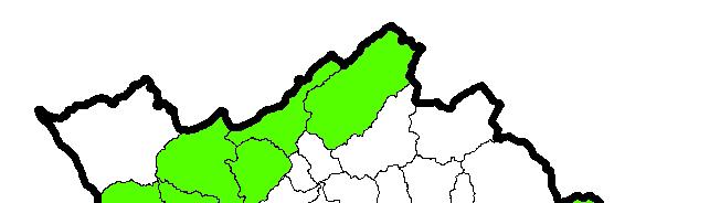
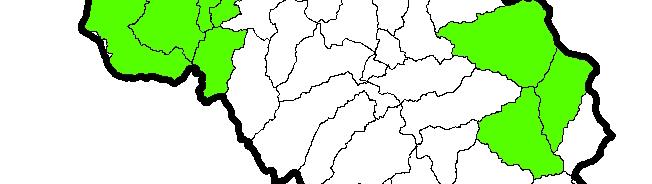
4 Brook Trout Range 1,433 subwatersheds 226 intact (green) 542 reduced (red) 595 extirpated (gray)
; Reduced (64%);")


5 CART Model : Extirpated (76%); Reduced (64%); Intact (79%) 1. % Forest 2. Deposition kg/ha 3. % Agriculture 4. Road Density km/km 2 5. % Forest Riparian
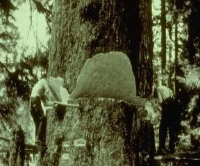
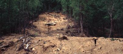

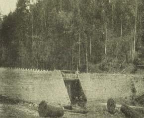
6 While many extirpations and losses occurred at the turn of the century, many documented losses have occurred in the last ten years. Threats: Dams Roads People Exotics Land use Genetic integrity Climate Change
7 Objectives

")


8 Today 's Objectives 1. Develop Metrics: a) correct scale b) cost effective c) detect meaningful change 2. Develop monitoring protocol for brook trout populations in the Chesapeake Bay watershed.
9 Scale


10 Sub-basins (4 th HUC) 100%


11 Subwatersheds (6 th HUC) 33%

12 Catchments 11%
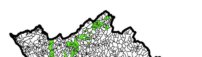
13 Fine Scale Occupancy Assessment In Chesapeake Bay Watershed*: 3,003 catchments: Allopatric Brook Trout Populations 1,716 catchments: Sympatric Populations (with Brown or Rainbow Trout) 1,966 catchments: Only Exotic Trout Species * excluding NY
14 Identification of Brook Trout Patches Patch = a group of contiguous catchments occupied by wild brook trout. Patches not connected physically Dams, warm water habitat, downstream invasive species Assumed to be genetically isolated populations


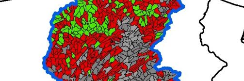
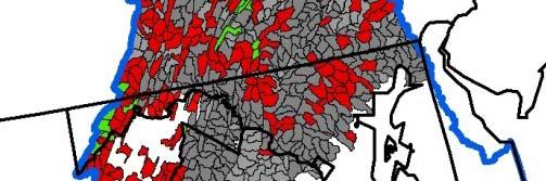
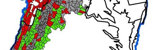
15 Patches USDA Forest Service Fish and Aquatic Ecology Unit


16 USDA Forest Service Fish and Aquatic Ecology Unit


")
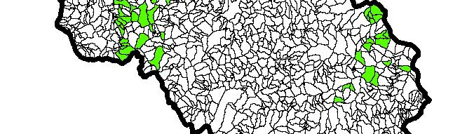
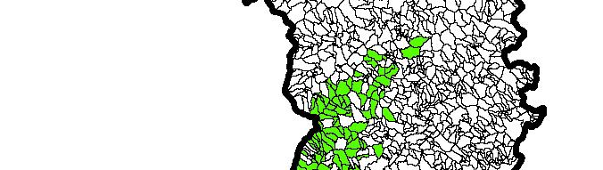
17 Chesapeake Bay Brook trout Patches Chesapeake Bay Brook trout Patches (n=868)
18 Patch - Populations Number of patches 868 Average size 1,541 ha Median size 855 ha USDA Forest Service Fish and Aquatic Ecology Unit
19 Lessons Learned
20 Current Population Estimates Mark-Recapture Depletion Removal Problems: Not viable for large scale monitoring Expense Inability to detect trend (i.e. large coefficient of variation % 50 adults; % 121 YOY) Expansion to entire stream
21 Patch Metrics

 D.")
22 Patch Metrics Spatial Metrics A. # of patches B. # of patches with increasing i size/connectivity(addition al upstream and downstream catchments with brook trout) C. # of patches decreasing in size/connectivity( loss of catchments) D. Average patch size of the entire resource E. # of patches with allopatric or sympatric(with brown or rainbow) populations
23 Genetic Patch Metrics
24 Two Genetic Monitoring Metrics 1. Estimates of the amount of genetic diversity within a patch can evaluate changes in relative abundance 2. Estimates of N b (# of individual brook trout(regardless of age) contributing to year class; Whiteley et al. 2012) Can serve as surrogate for estimates of census population size (N) Can be used to directly test changes in population size (Tallmon et al. 2010)
25 Interpreting the N b Metric Increasing N b trends: positive response from improved habitat or increasing population. Decreasing N b trends: suggest habitat a loss and decreasing populations.
26 Benefits of N b as a Sampling Protocol N b directly relates to annual recruitment. Easy to obtain reliable estimates Cost-benefit suggests N b alone can be a valuable surrogate for risk. VA pilot study Found number of breeders(n b ) often very low (<100 individuals) Monitoring patch metric changes(n, size, genetic diversity, and N b ) potentially a very cost-effective tool for monitoring wild populations of brook trout.
27 Genetic Sampling vs. Genetic Monitoring Sampling: Cost effective surrogate for population estimates (Tallmon et al. 2010). Taken at single point in time. Provides information on past population size (large populations retain more genetic diversity). Also provides insight into future resiliency to environmental changes. Monitoring: Sampling the same population at multiple points in time. Genetic monitoring can quantify temporal changes in population genetic metrics, as opposed to a snapshot population genetics assessment taken at a single point in time (Schwartz et al. 2007).
28 Results
29 Virginia Pilot Study Stream Name Patch Size (Ha) Adult N (95% CL) YOY N (95% CL) N b (95%CL) N b /N Fridley's Gap* (above Karl's dam) ( ) 460( ) 131 (95 192) 0.16 Skidmore Fork (above Todd Lake) (73 130) 70(50 117) 28 (14 93) 0.31 Dry Run (above Dry Run Dam) (42 44) 23(22 24) 5 (3 9) 0.10 Briery Branch (b (above Briery Branch Lake) k) ( ) 139(91 215) 26 (21 33) 0.20 Dry River (above Switzer lake) ( ) 1009( ) 67 (58 77) 0.10 Little River (above Hearthstone Lake) ( ) 677( ) 46 (40 53) 0.14
30 Virginia Pilot Study
31 Monitoring Design
32 Proposed Monitoring Design and Methods Cluster analysis to subsample existing 886 patches: Sentinel samples- (yearly trends) Panel samples every 5 years (long-term trends) Example: 250 sites from cluster analysis- 25 are designated sentinel to be sampled yearly. Additional 45 sites sampled yearly on a rotating panel (each site visited every 5 years) Equals 75 sites monitored per year.
33 Advantages of N b for Large Scale Monitoring 1. Estimate represents entire patch or population, not just the representative reach. 2. N b values are less than N(10-50%), and require fewer samples s for accurate estimation making them better suited for determining trends at numerous sites. 3. N b provides reliable at risk evaluation that integrates yearly variation of N. 4 Bonus information: genetic diversity within a patch indicates past 4. Bonus information: genetic diversity within a patch indicates past population size and resilience for future.


34 Thanks to the Partners!
35
Prepared by: Jason A. Coombs. Keith H. Nislow
 Riparian Prioritization and Status Assessment for Climate Change Resilience of Coldwater Stream Habitats within the Appalachian and Northeastern Regions Prepared by: Jason A. Coombs Keith H. Nislow University
Habitat GIT Fish Passage, Brook Trout, Cosatal Habitats STAC Workshop (Mike Slattery)
") Update: Fish Passage Workgroup, Habitat GIT Background The fish passage workgroup is part of the Habitat Goal Implementation Team. Fish Passage Outcome: During the period of 2011-2025, restore historical
Update: Fish Passage Workgroup, Habitat GIT Background The fish passage workgroup is part of the Habitat Goal Implementation Team. Fish Passage Outcome: During the period of 2011-2025, restore historical
Chesapeake Bay Watershed Brook Trout Habitat and Climate Change Vulnerability Assessment
 North Atlantic LCC Aquatic Habitat Assessment 2015 Chesapeake Bay Watershed Brook Trout Habitat and Climate Change Vulnerability Assessment Final Report submitted to the North Atlantic Landscape Conservation
Lake Superior Brook Trout Conservation and Prioritization Report. Prepared for Ashland Fish and Wildlife Conservation Office
 Lake Superior Brook Trout Conservation and Prioritization Report Prepared for Ashland Fish and Wildlife Conservation Office Contents 1. INTRODUCTION... 3 2. PREDICTIVE MODEL... 3 2.1 OBJECTIVES... 3 2.2
CHESAPEAKE BAY COMPREHENSIVE WATER RESOURCES AND RESTORATION PLAN. Habitat GIT Meeting 9 May 2017
 CHESAPEAKE BAY COMPREHENSIVE WATER RESOURCES AND 255 255 255 237 237 237 0 0 0 217 217 217 163 163 163 200 200 200 131 132 122 239 65 53 80 119 27 RESTORATION PLAN 110 135 120 252 174.59 112 92 56 62 102
Fish Habitat Management Strategy Outline
 Fish Habitat Management Strategy Outline Executive Summary 1. CBP Communications team will draft after the other sections are complete. Outcome and Baselines Fish Habitat Outcome: Continually improve effectiveness
JAMES J. ROBERTS. U.S. Geological Survey
 JAMES J. ROBERTS U.S. Geological Survey U.S. Department of the Interior U.S. Geological Survey Climate change and Cutthroat Trout conservation in the Southern Rocky Mountains (SRM) James J. Roberts USGS
Implications of Climate Change for Coldwater Habitat and Brook Trout in Pennsylvania
 Implications of Climate Change for Coldwater Habitat and Brook Trout in Pennsylvania Jefferson Tyrell Deweber Pennsylvania Cooperative Fish/Wildlife Research Unit Pennsylvania State University Tyler Wagner
Healthy Watersheds Assessment. Potomac Watersheds in West Virginia
 Healthy Watersheds Assessment Potomac Watersheds in West Virginia Watershed Assessment - Goals Develop metrics to measure current condition/function & threats Rank watersheds for restoration & protection
Penobscot II: Penobscot Habitat Blueprint Barrier Prioritization Tool: Assessing the Ecological Impacts of Barriers in the Penobscot River Basin
 University of Massachusetts Amherst ScholarWorks@UMass Amherst International Conference on Engineering and Ecohydrology for Fish Passage International Conference on Engineering and Ecohydrology for Fish
CHESAPEAKE BAY COMPREHENSIVE WATER RESOURCES AND RESTORATION PLAN - UPDATE. Update to Chesapeake Bay Program STAR January 25, 2018
 CHESAPEAKE BAY COMPREHENSIVE WATER RESOURCES AND RESTORATION 255 255 255 237 237 237 0 0 0 217 217 217 163 163 163 200 200 200 PLAN - UPDATE 131 132 122 239 65 53 80 119 27 110 135 120 252 174.59 112 92
CLIMATE CHANGE UNCERTAINTY IS NOT A PRIMARY IMPEDIMENT TO STREAM CONSERVATION
 1 CLIMATE CHANGE UNCERTAINTY IS NOT A PRIMARY IMPEDIMENT TO STREAM CONSERVATION Evan Grant USGS Patuxent Wildlife Research Center SO Conte Anadromous Fish Research Lab NECSC 17 May 2017 Rachel Katz, Allison
3.4 AQUATIC ECOSYSTEMS AND FISH SPECIES
 3.4 AQUATIC ECOSYSTEMS AND FISH SPECIES The following section supplements the analysis found in Chapter Three, Section 3.4 - Aquatic Ecosystems and Fish Species of the Draft EIS on page 3.59, Impacts Related
The Status of Rainbow Trout (Oncorhynchus mykiss) in the Stanislaus River Summary report of 2015 snorkel surveys
 in the Stanislaus River Summary report of 2015 snorkel surveys") The Status of Rainbow Trout (Oncorhynchus mykiss) in the Stanislaus River Summary report of 2015 snorkel surveys Prepared By: Matt Peterson Jason Guignard Andrea Fuller Doug Demko FISHBIO 1617 S. Yosemite
The Status of Rainbow Trout (Oncorhynchus mykiss) in the Stanislaus River Summary report of 2015 snorkel surveys Prepared By: Matt Peterson Jason Guignard Andrea Fuller Doug Demko FISHBIO 1617 S. Yosemite
Great Lakes Riparian Opportunity Assessment Methodology New York Natural Heritage Program September 25, 2015
 Great Lakes Riparian Opportunity Assessment Methodology New York Natural Heritage Program September 25, 2015 OBJECTIVES The goal of this analysis is to assemble a suite of riparian habitat quality indicators
Virtual Water Accounting: A New Framework for Managing Great Lakes Water Resources
 Virtual Water Accounting: A New Framework for Managing Great Lakes Water Resources Alex Mayer, Michigan Technological University Ben Ruddell, Arizona State University Stanley Mubako, University of Texas,
CONSERVATION RESERVE ENHANCEMENT PROGRAM
 Forested Buffers through United States Department of Agriculture s CONSERVATION RESERVE ENHANCEMENT PROGRAM NIKKI DAVIS Restoring streams, creating wildlife habitat, and improving water quality WHAT IS
Climate Change Impacts of Most Concern for CB Agreement Goal & Outcome Attainment
 Climate Change Impacts of Most Concern for CB Agreement Goal & Outcome Attainment Zoë P. Johnson, Climate Change Coordinator Chesapeake Bay Program STAC Workshop March 7-8, 2016 Climate Change: Real Consequences
Impervious Cover as a Indicator and Tool of Watershed Protection
 Impervious Cover as a Indicator and Tool of Watershed Protection Tom Schueler Director of Watershed Research & Practice Center for Watershed Protection Ellicott City, MD trs@cwp.org Key Themes A. The strength
Fishing and Boating: Past, Present, and Restoration Thoughts
 Fishing and Boating: Past, Present, and Restoration Thoughts West Branch Susquehanna River Douglas Austen Pennsylvania Fish and Boat Commission West Branch Basin Stream Resources Miles Category 1,249
Watershed Health Assessment Framework. Watershed Report Card:
 Watershed Health Assessment Framework "Managing for System Health" Watershed Report Card: People and Places: Watershed Population: 2 census - 1, 21 census - 1,7 Largest Cities - Population: Blackduck -
Cumulative Effects Monitoring: Lessons Learned from Development Monitoring in the Grand River. Latornell November
 Cumulative Effects Monitoring: Lessons Learned from Development Monitoring in the Grand River Latornell November 21 2017 Outline 1. Introduce the Project; Background on Blair Creek 2. Objectives 3. Cumulative
Riparian Restoration on California's Coast November 3, Reach scale
 Research and Adaptive Management Research approaches in stream corridor assessment and restoration Integral to all components Recognition of uncertainty Commitment to monitor and learn Willingness to adjust
Murray-Darling Basin. - Objectives Hierarchy -
 Murray-Darling Basin Strategic Adaptive Management - s Hierarchy - Context and Working Document Levels 1 and 2 are Hypothetical (but shown here for context going into Level-3) Level-3: s Hierarchy for
National Fish and Wildlife Foundation Central Appalachia Business Plan
 National Fish and Wildlife Foundation Central Appalachia Business Plan March 2019 Purpose of a Business Plan The purpose of a NFWF business plan is to provide a concise blueprint of the strategies and
Fish Habitat Outcome Management Strategy , v.1
 Management Strategy 2015 2025, v.1 I. Introduction Fish and shellfish in the Chesapeake Bay and its watershed rely on a variety of important habitats throughout the watershed. These habitats, which are
Climate Change: Impacts, Monitoring, and Solutions
 Climate Change: Impacts, Monitoring, and Solutions 1 Responding to Climate Change 1. Projections/Impacts 2. Adaptation and Resiliency 3. Monitoring 4. What about emissions? 2 Native trout and salmon are
Riparian Forest Buffers
 Quarterly Progress Meeting - August 2017 Riparian Forest Buffers Rebecca Hanmer Forestry Workgroup Chair Through the Chesapeake Bay Watershed Agreement, the Chesapeake Bay Program has committed to Vital
CACAPON INSTITUTE HAS BEEN ENGAGED WITH THE PWP SINCE PWP, AS YOU ALL KNOW IS A COLLABORATIVE OF FEDERAL, STATE, AND LOCAL ORGANIZATIONS
 FRANK RODGERS, DIRECTOR OF CACAPON INSTITUTE AND 9 YEAR ISA CERTIFIED ARBORIST WITH >15 YEARS EXPERIENCE IN WATERSHED FORESTRY BEGINNING IN BALTIMORE WHERE I WORKED ON THE NATIONS 1 ST URBAN TREE CANOPY
Development of standardized watershed assessment tools and techniques for Alberta
 Development of standardized watershed assessment tools and techniques for Alberta GeoAlberta Presentation September 25, 2013 Gillian Holloway, PhD Watershed Assessment In Alberta The Alberta Water for
Version 1.1, April Kurt Fesenmyer Trout Unlimited Science Program
 Central Appalachians Conservation Success Index: An assessment of brook trout habitat in Pennsylvania, West Virginia, Maryland, and Virginia, with focus on vulnerability to shale gas development 0 Version
the ability to manage for a stable and among the jurisdictions, and productive crab population and fishery by implement accountable monitoring
 Blue Crabs Add Bay-wide annual catch limits to Crab catch share included in Additional give predictability to fishermen, Issues for Consideration list. Blue Crab Management Outcome: Improve have an allocation
Growing Native. Hedrick Belin, Anna Wadhams, & Lien Vu
 Growing Native Hedrick Belin, Anna Wadhams, & Lien Vu Threats to the Potomac Watershed: Erosion Habitat Loss Impaired Waterways Invasive Species Climate Change How Growing Native Helps: Stabilize Streamside
Indicators: Characteristics, Qualities and Options. Peter Tango STAR Coordinator
 Indicators: Characteristics, Qualities and Options Peter Tango USGS@CBPO STAR Coordinator Indicators: A summary measure that provides information on the state of, or change in, the system that is being
Dianne Timmins - NH Fish and Game Dept. 1 Rachelle Lyons - PSU Center for Business and Community Partnerships
 Watershed Scale Crossing Assessment to Promote Community Restoration Priorities Dianne Timmins - NH Fish and Game Dept 1 Rachelle Lyons - PSU Center for Business and Community Partnerships ARSCAP Team
West Virginia Watershed Assessment Pilot Project Outline & Assessment Methodology March 2012
 Introduction The West Virginia Watershed Assessment Pilot Project was developed to define the methodology and identify the information and tools necessary to meet the project objectives stated below. The
What is Urban Tree Canopy?
 The following report was prepared by University of Vermont for Cacapon Institute in support of the WV UTC A&E project. Understanding our tree canopy is an essential first step in setting urban tree canopy
American Water Resources Association Philadelphia Metropolitan Area Section Philadelphia, PA 11/12/2014
 Nathan Boon American Water Resources Association Philadelphia Metropolitan Area Section Philadelphia, PA 11/12/2014 Stefanie A. Kroll, Ph.D. 1 The William Penn Foundation Private family foundation based
Stream Crossing Reconstruction on the Bog Dam Loop Road (FR15) Scoping Notice. Androscoggin Ranger District
 Scoping Notice. Androscoggin Ranger District") United States Department of Agriculture Forest Service White Mountain National Forest Stream Crossing Reconstruction on the Bog Dam Loop Road (FR15) Scoping Notice Androscoggin Ranger District Androscoggin
United States Department of Agriculture Forest Service White Mountain National Forest Stream Crossing Reconstruction on the Bog Dam Loop Road (FR15) Scoping Notice Androscoggin Ranger District Androscoggin
Riparian Buffers and Stream Restoration
 Riparian Buffers and Stream Restoration Why focus on riparian areas? Link land and water on any given site and link landscapes together in a watershed Riparian corridors protect the circulatory system
Prioritizing Climate Change Impacts and Action Strategies
 Prioritizing Climate Change Impacts and Action Strategies Chesapeake Bay Program STAC December 8, 2015 2014 Chesapeake Bay Agreement CLIMATE RESILIENCY GOAL: Increase the resiliency of the Chesapeake Bay
GIT 4 STRATEGY 1/22/2013
 GIT 4 STRATEGY 1/22/2013 [This version edited per 1/17/2013 GIT4 conference call] Purposes of this document: 1. to present a 2013 GIT 4 strategy using the CBP s adaptive management approach, including
Student Corner. Jack McLaren. Reservoir profiles uncover mechanism behind warming waters in the Henry s Fork
 Jack McLaren Student Corner Reservoir profiles uncover mechanism behind warming waters in the Henry s Fork Introduction: Study Location Island Park Reservoir (IPR) serves as an irrigation storage reservoir
WV WATERSHED ASSESSMENT PILOT PROJECT. Gauley River Kent Mason
 WV WATERSHED ASSESSMENT PILOT PROJECT Gauley River Kent Mason Expert Workshop #2, Round 2 Capitol Conference Center, Charleston. January 8 & 9, 2013 Workshop Outline Day 1 Project Background & Methodology
Hatchery Scientific Review Group Review and Recommendations
 Hatchery Scientific Review Group Review and Recommendations Willamette - River Coho Salmon Population and Related Hatchery Programs January 31, 2009 Columbia River Hatchery Reform Project - 1 - River Coho
Chesapeake Bay Updates. Agricultural Advisory Board June 18, 2014 Andy Zemba Interstate Waters Office
 Chesapeake Bay Updates Agricultural Advisory Board June 18, 2014 Andy Zemba Interstate Waters Office Updates Total Maximum Daily Load (TMDL) Chesapeake Bay Watershed Agreement Chesapeake Bay TMDL Progress
Influence of Land Use, and its Change, on Streams and Rivers
 Influence of Land Use, and its Change, on Streams and Rivers Ways in which land use alteration modifies streams. (from JD Allan 2004, Annu. Rev. Ecol., Evol. and Syst.) Dominant types of land use change:
Prince George Small Streams Project Present
 Prince George Small Streams Project 1999 Present Introduction The management of small-stream riparian zones is particularly important because small streams are a prominent feature in watersheds. Their
Status of the Ohio River Basin Fish Habitat Partnership
 Southern Illinois University Carbondale OpenSIUC Cache River Symposium Symposia 10-2010 Status of the Ohio River Basin Fish Habitat Partnership Nate Caswell US Fish and Wildlife Service Follow this and
How does sediment affect fish and macroinvertebrates?
 How does sediment affect fish and macroinvertebrates? How does sediment affect fish and macroinvertebrates? Suspended sediment (TSS): breathing, vision Sediment on streambed: egg development living space
UNRAVELING THE MYRAID OF STANDARDS AND TOOLS
 UNRAVELING THE MYRAID OF STANDARDS AND TOOLS HYDRO POWER DEVELOPMENT IN MEKONG REGION: CYCLING THROUGH FROM POLICY TO IMPLEMENTATION WORKSHOP SEPTEMBER 12-13, 2013 Basin Wide National regulations Project
Tioga County Conservation District Watershed Program
 Tioga County Conservation District Watershed Program What is a watershed? A watershed is the land area that drains into a stream, river, or body of water. In Tioga County, there are seven major watersheds,
Phase III Watershed Implementation Plans
 Phase III Watershed Implementation Plans Including programmatic outcomes in your planning to provide co-benefits for your community and reduce pollution Rachel Felver Chesapeake Bay Program Director of
Jan Moryk, Project Manager, Environmental Monitoring and Data Management Section, TRCA
 Distribution of Brook Trout in the TRCA Jurisdiction and what Legislation, Policies, and Guidelines do Conservation Authorities have at their disposal to Protect Brook Trout Habitat Jan Moryk, Project
SCIENCE PRIORITIES OF THE
 SCIENCE PRIORITIES OF THE GOAL IMPLEMENTATION TEAMS AND WORKGROUPS STAC Meeting December 9, 2015 Scientific, Technical Assessment and Reporting Team Presenters: Scott Phillips & Mindy Ehrich OUTLINE Interacting
Water and Watersheds. Data Maps Action
 Water and Watersheds Data Maps Action What is the Wildlife Action Plan? Restore rare wildlife and habitats. Keep common species common. 2015 Revision: Partners in Conservation Science 2015 Revision Data
Sustainable Recreation
 Sustainable Recreation Sustainable Recreation An enjoyable way to be healthy, spiritual, and contribute to economic development while conserving resources for future generations. Sustainable Recreation
A Bird s Eye View of Habitat. Putting the pieces together
 A Bird s Eye View of Habitat Putting the pieces together Restoration Ecology Using what science has learned about living things and their interactions with their environment to re-create habitats that
Sustainable Fisheries GIT: Fish Habitat
 Quarterly Progress Meeting - May 2017 Chesapeake Bay Program Science. Restoration Partnership. Sustainable Fisheries GIT: Fish Habitat Bruce Vogt, NOAA and Sustainable Fisheries GIT Coordinator Gina Hunt,
How Much is Too Much? Effects-Based versus Stressor-Based Benchmarks and Thresholds and Some Examples from the Elk Valley in the East Kootenays
 How Much is Too Much? Effects-Based versus Stressor-Based Benchmarks and Thresholds and Some Examples from the Elk Valley in the East Kootenays Outline 1. Effects-based versus stressor-based indicators,
How Much Habitat is Enough?
 How Much Habitat is Enough? Canadian Wildlife Service 2017 Third Edition Page 2 April 19, 2017 Grasslands Forest Wetlands Riparian & Watershed Page 3 April 19, 2017 Significant impairment in stream At
Habitat and Fragmentation Impacts: A Perspective from Landscape Ecology. Todd BenDor Wuhan 2017
 Habitat and Fragmentation Impacts: A Perspective from Landscape Ecology Todd BenDor bendor@unc.edu Wuhan 2017 Presentation Overview Introduction to habitat issues Habitat loss Habitat Fragmentation Assessment
Riparian Forest Buffer (RFB) Management Strategy CBP Work Plan Virginia
 Management Strategy CBP Work Plan Virginia") Riparian Forest Buffer (RFB) Management Strategy CBP Work Plan Virginia Goal: Vital Habitats: Restore, enhance and protect a network of land and water habitats to support fish and wildlife, and to afford
Riparian Forest Buffer (RFB) Management Strategy CBP Work Plan Virginia Goal: Vital Habitats: Restore, enhance and protect a network of land and water habitats to support fish and wildlife, and to afford
Carp Creek 2013 Summary Report
 Monitoring Activity in the Carp River Watershed In 2012, Mississippi Valley Conservation Authority (MVCA) worked with Friends of the Carp River (FCR) on a preliminary assessment of the Carp River. This
Oregon Administrative Rules Oregon Department of Fish and Wildlife
 DIVISION 400 INSTREAM WATER RIGHTS 635-400-0000 Purpose (1) These rules set the policy, procedures, criteria, standards, including flow methodologies, and definitions for instream water right applications
Hood River Watershed Group to sustain and improve the Hood River watershed through education, cooperation, and stewardship
 You are living in a watershed A watershed is the land area that drains to a particular lake, stream, or river. The Hood River watershed covers 339 square miles between Mt. Hood and the Columbia River.
awetlands aprairie aforests ahabitat for Fish, Game & Wildlife
 Rec. H1 priority land habitats pp. 63-67 Priority areas identified in integrated mapping assessing critical land habitat and threats to habitat pp.33-63 o Mapping is scalable for use in localized areas
The status of aquatic ecosystems in the Basin
 AQUATIC SPECIES AND HABITATS The status of aquatic ecosystems in the Basin is influenced by both natural and human processes. The geologic and geomorphic processes described earlier formed and continue
H ollow R iver. Stewardship Works! S ubwatershed. Grades. Land Water Wetlands Biodiversity. Not Stressed Not Stressed Not Stressed Vulnerable
 s H ollow R iver Land Water Wetlands Biodiversity S ubwatershed T he Hollow River Subwatershed is 40,863 hectares in size and lies predominantly in the Township of Algonquin Highlands in Haliburton County.
Lower Columbia Coho Existing Populations
 Lower Columbia Coho Existing Populations This SMU includes eight populations in tributaries from the Columbia River mouth to Fifteenmile Creek upstream of Hood River. A population upstream from Willamette
Buffers improve water quality
 Buffers improve water quality Recently, the MPCA had a request asking if we could see a difference in water quality in streams from sites where there are buffers compared to sites without buffers. We looked
THE CHALLENGE OF NUTRIENT CONTROL IN LARGE SCALE WATERSHEDS: EFFORTS IN THE U.S.
 THE CHALLENGE OF NUTRIENT CONTROL IN LARGE SCALE WATERSHEDS: EFFORTS IN THE U.S. NAE Convocation of the Professional Engineering Societies David Dzombak Carnegie Mellon University May 16, 2011 OUTLINE
Session B4- Freshwater fish and aquatic macroinvertebrate biomonitoring of the Eel River Headwaters Restoration sites in Plymouth, Massachusetts
 University of Massachusetts - Amherst ScholarWorks@UMass Amherst International Conference on Engineering and Ecohydrology for Fish Passage International Conference on Engineering and Ecohydrology for Fish
Presented by Jack Pflaumer
 Presented by Jack Pflaumer Bureau of Environmental Analysis, Restoration and Standards Division of Water Monitoring and Standards New Jersey Department of Environmental Protection February 23, 2017 Agenda
Virginia's Mountain Steams: What Thirty Years of. Acid Rain and Climate Change
 Virginia's Mountain Steams: What Thirty Years of Research tells us about Future Impacts of Acid Rain and Climate Change Todd Scanlon Jim Galloway Jack kcosby Rick Webb Drew Robison Department of Environmental
Hydroecological tool: enhancements and results. enhancements and results. Marci Meixler. Project partners: Sponsored by:
 Hydroecological tool: Marci Meixler Sponsored by: Project partners: Motivation Great Lakes Charter Annex establish uniform, regional protections for Great Lakes waters ensure that authority over the Lake
Jan Moryk, Project Manager, Environmental Monitoring and Data Management Section, TRCA
 Distribution of Brook Trout in the TRCA Jurisdiction and what Legislation, Policies, and Guidelines do Conservation Authorities have at their disposal to Protect Brook Trout Habitat Jan Moryk, Project
Red Clover/McReynolds Creek Restoration Project Monitoring Report Ryan Nupen fly fishing in project area June (Photo G.
 Red Clover/McReynolds Creek Restoration Project Monitoring Report 2010 Ryan Nupen fly fishing in project area June 2010. (Photo G. Martynn) Feather River Coordinated Resource Management Plumas Corporation
Cold Waters Temperature Assessment across the Northeast
 Cold Waters Temperature Assessment across the Northeast March 23, 2012 Jennifer M. Jacobs, Erik Carlson, and Emily Carlson Environmental Research Group Department of Civil Engineering University of New
Chesapeake Bay Watershed Agreement Final draft January 29, 2014
 Chesapeake Bay Watershed Agreement Final draft January 29, 2014 Public comment invited through March 17, 2014. Visit: www.chesapeakebay.net/watershedagreement 1 Preamble The Chesapeake Bay watershed is
Sensitivity and Vulnerability of Brook Trout Populations to Climate Change
 Sensitivity and Vulnerability of Brook Trout Populations to Climate Change Brad Trumbo and Mark Hudy* U.S. Forest Service, Fish and Aquatic Ecology Unit, James Madison University, Mail Stop Code 7801,
Recent Developments in Water Withdrawal Management
 Recent Developments in Water Withdrawal Management Frank Ruswick David A. Hamilton Michigan Department of Environmental Quality Overview What Water Withdrawals are regulated? Water Withdrawal Assessment
MERGANSER - An empirical model to estimate fish and loon Hg in New England lakes
 MERGANSER - An empirical model to estimate fish and loon Hg in New England lakes DTMC webinar, September 6, 2011 Project Team Building MERGANSER 1. Choose base map: National Wetlands Inventory (NWI) 2.
TARGETING WATERSHEDS FOR RESTORATION ACTIVITIES IN THE CHESAPEAKE BAY WATERSHED. Technical Documentation October 4, 2002
 TARGETING WATERSHEDS FOR RESTORATION ACTIVITIES IN THE CHESAPEAKE BAY WATERSHED Technical Documentation October 4, 2002 Acknowledgements and Disclaimer This project was funded by the Chesapeake Bay Foundation,
GRANTS TO ACCELERATE WATERSHED PROTECTION Grants totaling more than $4 million to protect America s watersheds--
 NEWS GRANTS TO ACCELERATE WATERSHED PROTECTION -- 22 Grants totaling more than $4 million to protect America s watersheds-- U.S. Endowment for Forestry and Communities, Greenville, SC For IMMEDIATE RELEASE
Marinette County Lower Peshtigo River Watershed Management Plan
 Marinette County Lower Peshtigo River Watershed Management Plan MARINETTE COUNTY S EXPERIENCES CREATING A NINE KEY ELEMENT PLAN Plan Goals Learn more about the biota, environmental health, and human health
Food web and landscape approaches to aquatic conservation
 Food web and landscape approaches to aquatic conservation M. Jake Vander Zanden Department of Zoology & Center for Limnology Drivers of aquatic ecosystem change Invasive species Harvest Agricultural pollution
New Approaches to Watershed Modelling Using STELLA. WeSMART Conference, December 11, 2014 Heather Cray & Michael McTavish
 New Approaches to Watershed Modelling Using STELLA WeSMART Conference, December 11, 2014 Heather Cray & Michael McTavish Ecosystem Modelling What are models and ecosystem models? Broadly, a model is a
Wood-Pawcatuck Watershed Flood Resiliency Management Plan Community Meeting October 20, 2016
 Wood-Pawcatuck Watershed Flood Resiliency Management Plan Community Meeting October 20, 2016 Wood-Pawcatuck Watershed Association Meeting Agenda 10:00 10:05 Introductions and Meeting Goals 10:05 10:15
MiCorps 101. Presented by Paul Steen. & MiCorps Staff
 MiCorps 101 Presented by Paul Steen & MiCorps Staff MiCorps Team Bill Dimond Laura Kaminski Anne Sturm Dina Klemens Paul Steen, Ph.D. Jason Frenzel Scott Brown Jean Roth Jo Latimore, Ph.D. Together, we
Enhancing Habitat for Early Successional Species
 Enhancing Habitat for Early Successional Species NFWF CONTACT Amanda Bassow Director, Eastern Partnership Office amanda.bassow@nfwf.org 202-595-2476 and its operating companies Connecticut Light & Power,
THE PROCESS OF NATURAL RESOURCE MANAGEMENT AND THE
 WMAN 175: Introduction to Wildlife and Fisheries Resources THE PROCESS OF NATURAL RESOURCE MANAGEMENT AND THE ROLE OF SCIENCE Petty Notes February 21, 2008 Educational Goal of the Wildlife and Fisheries
PLANT AND ANIMAL DIVERSITY
 by the planning rule team as of. These ideas are for discussion purposes and do not What we want to achieve PLANT AND ANIMAL DIVERSITY The Forest Service is committed to protecting species and sustaining
Water Quality Ecosystem Services in the Urban Environment
 Water Quality Ecosystem Services in the Urban Environment Dianna Hogan and JV Loperfido ACES 2010 December 7, 2010 U.S. Department of the Interior U.S. Geological Survey Water Quality Ecosystem Services
Influence of Land Use, and its Change, on Streams and Rivers
 Influence of Land Use, and its Change, on Streams and Rivers Ways in which land use alteration modifies streams. (from JD Allan 2004, Annu. Rev. Ecol., Evol. and Syst.) Dominant types of land use change:
Status and Challenges of Redside Dace in Lynde Creek
 Status and Challenges of Redside Dace in Lynde Creek Jeff McNeice Fisheries Biologist, CLOCA Ian Kelsey Aquatic Resource Analyst, CLOCA Outline Previous Studies (Background) Lynde Creek vs. Other Watersheds
Anadromous Fish Reintroduction in the Upper Columbia River Basin An Overview
 University of Massachusetts Amherst ScholarWorks@UMass Amherst International Conference on Engineering and Ecohydrology for Fish Passage International Conference on Engineering and Ecohydrology for Fish
ADDRESSING CLIMATE CHANGE ADAPTATION IN EASTERN ONTARIO APRIL 15, 2013
 ADDRESSING CLIMATE CHANGE ADAPTATION IN EASTERN ONTARIO APRIL 15, 2013 IPCC DEFINITION UNFCCC DEFINITION Climate change in Intergovernmental Panel on Climate Change (IPCC) usage refers to a change in the
Jordan River Total Maximum Daily Load (TMDL) Phase 1
 Phase 1") Jordan River Total Maximum Daily Load (TMDL) Phase 1 Presentation at Salt Lake County Watershed Symposium September 27, 2012 http://www.waterquality.utah.gov/tmdl/jordan_tmdl.htm What causes low oxygen
Jordan River Total Maximum Daily Load (TMDL) Phase 1 Presentation at Salt Lake County Watershed Symposium September 27, 2012 http://www.waterquality.utah.gov/tmdl/jordan_tmdl.htm What causes low oxygen