Water Well Report. Site Name
|
|
|
- Josephine Reed
- 6 years ago
- Views:
Transcription
1 Prepared for: Banks Environmental Data 1601 Rio Grande Ste 500 Austin, TX Water Well Report Roseland Park Baytown, TX PO #:
2 Table of Contents Geographic Summary 3 Maps Summary Map Mile Buffer 4 Topographic Overlay Map Mile Buffer 5 Current Imagery Overlay Map Mile Buffer 6 Water Well Details 7 Soils Sub-Report Soil Survey Map Mile Buffer 16 Soils Details 17 Soils Definitions 20 Database Definitions and Sources 21 Disclaimer 22 Page 2
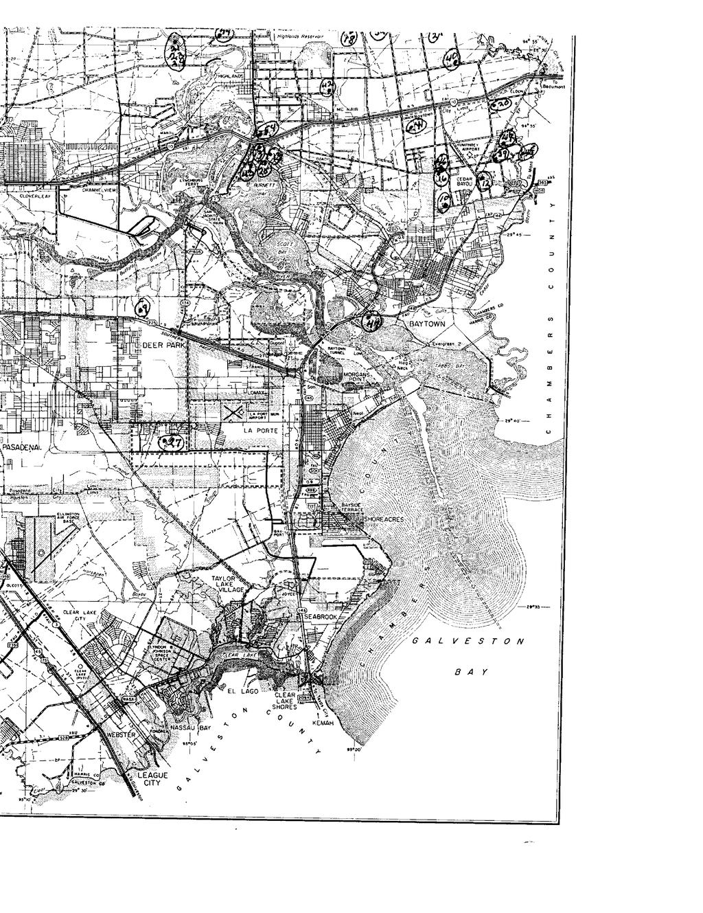
3 Geographic Summary Location TX Target location is square miles and has a 0.81 mile perimeter Coordinates Longitude & Latitude in Degrees Minutes Seconds Longitude & Latitude in Decimal Degrees X and Y in UTM NA NA NA Elevation NA Zip Codes Searched Search Distance Zip Codes Target Property 77520, miles 77520, 77523, 77523, 77520, 77521, 77535, Topos Searched Search Distance Topo Name Target Property Morgans Point 0.5 miles Morgans Point Page 3


4 Summary Map Mile Buffer Well Target Property 1 : 13,000 Well Cluster Search Buffer Texas Quad Index Lambert Conformal Conic Projection 1983 North American Datum First Standard Parallel: 33 0' 00" North Second Standard Parallel: 45 0' 00" North Central Meridian: 96 0' 00" West Latitude of Origin: 39 0' 00" North Page 4

5 Topographic Overlay Map Mile Buffer Well Target Property 1 : 13,000 Well Cluster Search Buffer Lambert Conformal Conic Projection 1983 North American Datum First Standard Parallel: 33 0' 00" North Second Standard Parallel: 45 0' 00" North Central Meridian: 96 0' 00" West Latitude of Origin: 39 0' 00" North Page 5


6 Current Imagery Overlay Map Mile Buffer Well Target Property 1 : 13,000 Well Cluster Search Buffer Lambert Conformal Conic Projection 1983 North American Datum First Standard Parallel: 33 0' 00" North Second Standard Parallel: 45 0' 00" North Central Meridian: 96 0' 00" West Latitude of Origin: 39 0' 00" North Page 6
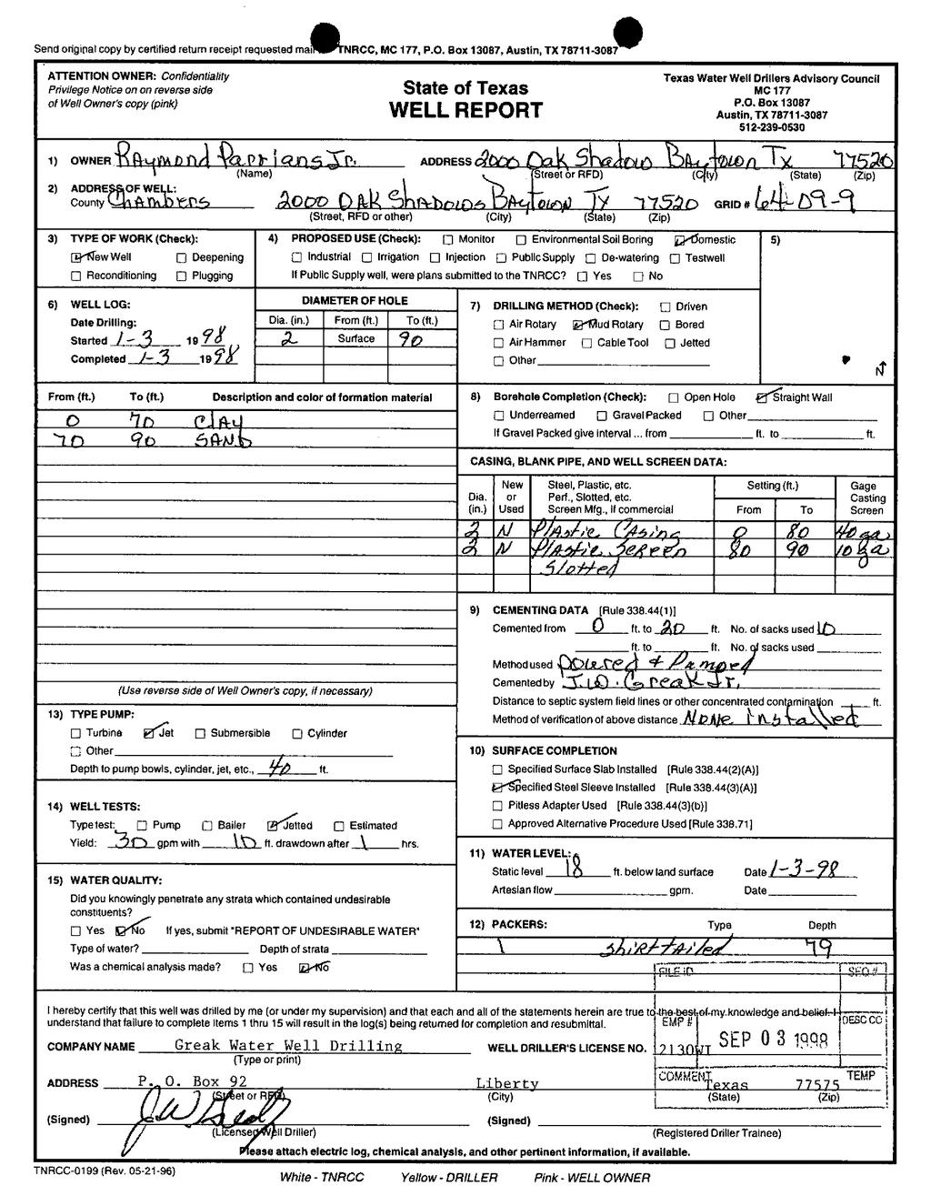
7 Water Well Details Map ID Source ID Dataset Owner of Well Type of Well Depth Drilled Completion Date Longitude Latitude Elevation Driller's Logs TX TCEQ HIST Raymond Parrians Domestic 90 01/03/ ft View TX TCEQ HIST H. E. Maris Domestic /26/ ft View D TX TCEQ HIST WES HARTLESS Domestic /28/ ft View 4 USGS WW USGS USGS Not Reported /16/ ft N/A TX TWDB GW Holsch Tubular Prod. Industrial /16/ ft N/A 5 HGSDHG2 594 TX HGSD MONSANTO COMPANY Irrigation 90 01/01/ ft N/A H TX TCEQ HIST WES HARTLESS Domestic /25/ ft View J TX TCEQ HIST WES HARTLESS Domestic /25/ ft View 8 WIID TX TWDB WIID Martin Fraysur Domestic 245 8/27/ ft View Well Summary Water Well Dataset # of Wells TX HGSD 1 TX TCEQ HIST 5 TX TWDB GW 1 TX TWDB WIID 1 WW USGS 1 Total Count 9 Page 7
8
9
10
11
12
13
14
15

16 Soil Survey Map Mile Buffer Well Target Property 1 : 5,000 Well Cluster Search Buffer Soils Boundary Lambert Conformal Conic Projection 1983 North American Datum First Standard Parallel: 33 0' 00" North Second Standard Parallel: 45 0' 00" North Central Meridian: 96 0' 00" West Latitude of Origin: 39 0' 00" North Page 16
17 Soils Soils Types Found Target Property Within 0.1 miles of Target Property W, Vn, Ha W, LaB, Ve, W, Vn, Bc, Ha, Ba, Ha, Is Soil Type Descriptions Ba - Beaumont clay Hydric Status Minimum Depth to Bedrock Beaumont (95 percent) Hydrologic Group Soil Drainage Class Corrosion Potential - Uncoated Steel Depth to Restrictive Feature Some components are hydric and some components are not hydric. High runoff potential Poorly drained High Horizon Soil Texture Upper Boundary Lower Boundary AASHTO Unified H1 clay 0 cm 23 cm A-7-6 CH H2 clay 23 cm 53 cm A-7-6 CH H3 clay 53 cm 150 cm A-7-6 CH H4 clay 150 cm 185 cm A-7-6 CH Unnamed, minor components (5 percent) Bc - Beaumont-Urban land complex Hydric Status Minimum Depth to Bedrock Beaumont (55 percent) Hydrologic Group Soil Drainage Class Corrosion Potential - Uncoated Steel Depth to Restrictive Feature Some components are hydric and some components are not hydric. High runoff potential Poorly drained High Horizon Soil Texture Upper Boundary Lower Boundary AASHTO Unified H1 clay 0 cm 23 cm A-7-6 CH H2 clay 23 cm 53 cm A-7-6 CH H3 clay 53 cm 150 cm A-7-6 CH H4 clay 150 cm 185 cm A-7-6 CH Urban land (35 percent) Horizon Soil Texture Upper Boundary Lower Boundary AASHTO Unified H1 variable 0 cm 102 cm Unnamed, minor components (10 percent) Ha - Harris clay Hydric Status Minimum Depth to Bedrock Harris (90 percent) Hydrologic Group Soil Drainage Class Corrosion Potential - Uncoated Steel Depth to Restrictive Feature Some components are hydric and some components are not hydric. High runoff potential Very poorly drained High Horizon Soil Texture Upper Boundary Lower Boundary AASHTO Unified H1 clay 0 cm 48 cm A-7-6 CH H2 clay 48 cm 112 cm A-7-6 CH H3 clay 112 cm 152 cm A-7-6 CH Page 17
18 Soils Unnamed, minor components (10 percent) Is - Ijam soils Hydric Status Minimum Depth to Bedrock Ijam (95 percent) Hydrologic Group Soil Drainage Class Corrosion Potential - Uncoated Steel Depth to Restrictive Feature Some components are hydric and some components are not hydric. High runoff potential Poorly drained High Horizon Soil Texture Upper Boundary Lower Boundary AASHTO Unified H1 clay 0 cm 20 cm A-7-6 CL H2 clay 20 cm 152 cm A-7-6 CH Unnamed, minor components (5 percent) LaB - Lake Charles clay, 1 to 5 percent slopes Hydric Status Minimum Depth to Bedrock Lake Charles (95 percent) Hydrologic Group Soil Drainage Class Corrosion Potential - Uncoated Steel Depth to Restrictive Feature All components are not hydric and no components are unranked. High runoff potential Moderately well drained High Horizon Soil Texture Upper Boundary Lower Boundary AASHTO Unified H1 clay 0 cm 25 cm A-7-6 CH H2 clay 25 cm 51 cm A-7-6 CH H3 clay 51 cm 178 cm A-7-6 CH H4 clay 178 cm 203 cm A-7-6 CH Unnamed, minor components (5 percent) Ve - Veston soils Hydric Status Minimum Depth to Bedrock Veston (85 percent) Hydrologic Group Soil Drainage Class Corrosion Potential - Uncoated Steel Depth to Restrictive Feature Some components are hydric and some components are not hydric. Moderately high runoff potential when drained and high runoff potential undrained Poorly drained High Horizon Soil Texture Upper Boundary Lower Boundary AASHTO Unified H1 silt loam 0 cm 20 cm A-4, A-6 CL H2 silty clay loam 20 cm 160 cm A-6, A-7 CH, CL Unnamed, minor components (15 percent) Vn - Vamont-Urban land complex Hydric Status Minimum Depth to Bedrock Vamont (50 percent) Hydrologic Group Soil Drainage Class Corrosion Potential - Uncoated Steel Depth to Restrictive Feature All components are not hydric and no components are unranked. High runoff potential Somewhat poorly drained High Page 18
19 Soils Horizon Soil Texture Upper Boundary Lower Boundary AASHTO Unified H1 clay 0 cm 20 cm A-7-6 CH H2 clay 20 cm 178 cm A-7-6 CH, CL H3 clay 178 cm 203 cm A-7-6 CH Urban land (35 percent) Horizon Soil Texture Upper Boundary Lower Boundary AASHTO Unified H1 variable 0 cm 102 cm Unnamed, minor components (15 percent) W - Water (greater than 40 acres in size) Hydric Status Minimum Depth to Bedrock All components are not hydric and no components are unranked. Water (100 percent) W - Water Hydric Status Minimum Depth to Bedrock All components are not hydric and no components are unranked. Water (100 percent) Page 19
20 Soils Descriptions AASHTO Classification Definitions A-1, A-1-a, A-1-b Granular materials (35% or less passing No. 200 sieve), sonte fragments, gravel and sand A-2, A-2-4, A-2-5, A-2-6, A-2-7 Granular materials (35% or less passing No. 200 sieve), silty or clayey gravel and sand A-3 Granular materials (35% or less passing No. 200 sieve), fine sand A-4 Silt-Clay materials (more than 35% passing No. 200 sieve), silty soils A-5 Silt-Clay materials (more than 35% passing No. 200 sieve), silty soils A-6 Silt-Clay materials (more than 35% passing No. 200 sieve), clayey soils A-7, A-7-5, A-7-6 Silt-Clay materials (more than 35% passing No. 200 sieve), clayey soils A-8 Silt-Clay materials (more than 35% passing No. 200 sieve), clayey soils Unified Classification Definitions CH CL, CL-A (proposed), CL-K (proposed), CL-ML, CL-O (proposed), CL-T (proposed) GC, GC-GM GM GP, GP-GC, GP-GM GW, GW-GC, GW-GM MH, MH-A, MH-K, MH-O, MH-T ML, ML-A (proposed), ML-K (proposed), ML-O (proposed), ML-T (proposed) OH, OH-T (proposed) OL PT SC, SC-SM SM SP, SP-SC, SP-SM SW, SW-SC, SW-SM Fine-grained soils, silts and clays (liquid limit is 50% or more), Fat Clay Fine-grained soils, silts and clays (liquid limit is less than 50%), Lean Clay Coarse-grained soils, Gravels, gravel with fines, Clayey Gravel Coarse-grained soils, Gravels, gravel with fines, Silty Gravel Coarse-grained soils, Gravels, clean gravels, Poorly Graded Gravel Coarse-grained soils, Gravels, clean gravels, Well-Graded Gravel Fine-grained soils, silts and clays (liquid limit is 50% or more), Elastic Silt Fine-grained soils, silts and clays (liquid limit is less than 50%), Silt Fine-grained soils, silts and clays (liquid limit is 50% or more), Organic Clay or Organic Silt Fine-grained soils, silts and clays (liquid limit is less than 50%), Organic Clay or Organic Silt Highly organic soils, Peat Coarse-grained soils, Sands, sands with fines, Clayey Sand Coarse-grained soils, Sands, sands with fines, Silty Sand Coarse-grained soils, Sands, clean sands, Poorly Graded Sand Coarse-grained soils, Sands, clean sands, Well-Graded Sand Source Natural Resources Conservation Service, Soil Survey Geographic (SSURGO) Database. Disclaimer This Soils Survey from Banks Environmental Data, Inc. has searched Natural Resources Conservation Service (NRCS) and the Soil Survey Geographic Database (SSURGO). All soil data presented on the map and in the details section are based on information obtained from NRCS. Although Banks performs quality assurance and quality control on all data, inaccuracies of the data and mapped locations could possibly be traced to the source. Banks Environmental Data, Inc. cannot fully guarantee the accuracy of the SSURGO database maintained by NRCS. Page 20
21 Dataset Descriptions and Sources Dataset Source Dataset Description Update Schedule Data Requested Data Obtained Data Updated Source Updated TX HGSD - Texas HGSD TX TCEQ HIST - Texas TCEQ Historical TX TCEQ PWS - Texas TCEQ PWS TX TWDB GW - Texas TWDB Groundwater Database TX TWDB WIID - Texas TWDB Submitted Drillers' Logs WW USGS - USGS Water Wells Harris Galveston Subsidence District/Fort Bend Subsidence District Texas Commission on Environmental Quality Texas Commission on Environmental Quality Texas Water Development Board Texas Water Development Board U.S. Geological Survey This dataset contains all groundwater well records compiled by Harris Galveston Subsidence District/Fort Bend Subsidence District. This dataset contains all historical water well records searched from the TCEQ Public Water Well Viewer. Banks Environmental Data plots each well record based on location information found on the log. This dataset contains a collection of records from Texas Water Districts, Public Drinking Water Systems and Water and Sewer Utilities who submit information to the TCEQ. This dataset contains water well records contained within Texas Water Development Board Groundwater Database. This dataset contains water well records from the Texas Water Development Board Submitted Driller's Reports Database. This dataset contains groundwater well records from the U.S. Geological Survey. Quarterly 06/19/ /19/ /07/ /19/2013 As requested N/A N/A N/A N/A Quarterly 06/13/ /13/ /07/ /10/2013 Quarterly 04/11/ /02/ /11/ /11/2013 Quarterly 07/03/ /03/ /05/ /01/2013 Quarterly 07/08/ /08/ /08/ /08/2013 Page 21
22 Disclaimer The Banks Environmental Data Water Well Report was prepared from existing state water well databases and/or additional file data/records research conducted at the state agency and the U.S. Geological Survey. Banks Environmental Data has performed a thorough and diligent search of all groundwater well information provided and recorded. All mapped locations are based on information obtained from the source. Although Banks performs quality assurance and quality control on all research projects, we recognize that any inaccuracies of the records and mapped well locations could possibly be traced to the appropriate regulatory authority or the actual driller. It may be possible that some water well schedules and logs have never been submitted to the regulatory authority by the water driller and, thus, may explain the possible unaccountability of privately drilled wells. It is uncertain if the above listing provides 100% of the existing wells within the area of review. Therefore, Banks Environmental Data cannot fully guarantee the accuracy of the data or well location(s) of those maps and records maintained by the regulatory authorities. Page 22
SECTION 500 STRUCTURES
 SECTION 500 STRUCTURES 500.1 GENERAL This section defines the various construction items that are associated with the completion of a concrete, steel, timber, or masonry unit structures, or a combination
SECTION UTILITY BACKFILL MATERIALS
 SECTION 31 23 23 UTILITY BACKFILL MATERIALS PART 1: GENERAL 1.01 SECTION INCLUDES A. Material Classifications B. : 1. Concrete sand 2. Gem sand 3. Pea gravel 4. Crushed stone 5. Crushed concrete 6. Bank
Typical Subsurface Profile. November 28, 2016
 November 28, 2016 RSCCD Facility Planning, District Construction and Support Services 2323 N. Broadway, Suite 112, Santa Ana, CA 92706 Attn: Re: Ms. Allison Coburn Facilities Project Manager P: (714) 480-7530
Thi_ Qar University College of Engineering/Civil Engineering Department. Highway Lectures. Fourth Class. Part #2: - Subgrade Soil
 Thi_ Qar University College of Engineering/Civil Engineering Department Highway Lectures Fourth Class Part #2: - Subgrade Soil Lecture #2 Soil Classification DAS, Chapter 4, Engineering Classification
WILLMER ENGINEERING INC. Willmer Project No Prepared for. Clark Patterson Lee Suwanee, Georgia. Prepared by
 SOIL SURVEY REPORT (Revised March 6, 2013) New Hospital Connector Road GDOT Project No. CSSTP-0006-00(276), PI No. 0006276 Duluth, Gwinnett County, Georgia WILLMER ENGINEERING INC. Willmer Project No.
SOIL MECHANICS Assignment #2: Soil Classification Solution.
 Geotechnical Engineering Research Laboratory One University Avenue Lowell, Massachusetts 01854 Edward L. Hajduk, D.Eng, PE Lecturer PA105D Tel: (978) 934 2621 Fax: (978) 934 3052 e mail: Edward_Hajduk@uml.edu
PD - 6 THRUST RESTRAINT DESIGN EQUATIONS AND SOIL PARAMETERS FOR DUCTILE IRON AND PVC PIPE
 PD - 6 THRUST RESTRAINT DESIGN EQUATIONS AND SOIL PARAMETERS FOR DUCTILE IRON AND PVC PIPE 4 3 2 1 D D C C B B A A 4 3 2 1 Thrust Restraint Design Equations and Soil Parameters These equations and soil
 Appendix A - Vicinity Map Vicinity Map: Palm Beach Gardens City Hall Additions, 000 N Military Trail, Palm Beach Gardens, FL Proposed Location of Police Dept. Attached Addition Proposed Location of New
Concrete basement walls are
 DESIGNING Concrete Basement Walls Make sure the wall is strong enough to resist the lateral pressure of the soil Concrete basement walls are designed to do two main jobs. One job is supporting the house;
CONTRACT 5E-2 APPENDIX A - TEST HOLE LOGS DYREGROV ROBINSON INC. PORTAGE AVE WINSTON DR BOURKEVALE CAVELL PARKSIDE DR ASSINIBOINE AVE
 APPENDIX A - TEST HOLE LOGS PORTAGE AVE TH -9 CONTRACT E- DR DR BOURKEVALE CAVELL WINSTON DR PARKSIDE DR ASSINIBOINE AVE AUTHORIZED BY: DATE: CONSULTING GEOTECHNICAL ENGINEERS AUTHORIZED /0/ CLIENT DRAWING
SECTION 6. ROAD CONSTRUCTION STANDARDS
 SECTION 6. ROAD CONSTRUCTION STANDARDS Construction of new roads or reconstruction of existing roads proposed for dedication to the County shall conform to the standards set forth in this section. Roads
Geotechnical Engineering Report
 Geotechnical Engineering Report Turner Turnpike Widening Milepost 210 to 218 Drainage Structure Pipe Jacking Creek County, Oklahoma July 1, 2016 Terracon Project No. 04165017 Prepared for: Benham Tulsa,
VOCs, including fuel oxygenates, via EPA Analytical Method The second soil sample from MW-24 (MW ) was analyzed for Total Organic Carbon.
 was analyzed for Total Organic Carbon.") December 5, 2012 Mrs. Jenny Herman Maryland Department of the Environment Oil Control Program 1800 Washington Boulevard Baltimore, Maryland 212301719 Re: Additional Monitoring Well Installation Report
December 5, 2012 Mrs. Jenny Herman Maryland Department of the Environment Oil Control Program 1800 Washington Boulevard Baltimore, Maryland 212301719 Re: Additional Monitoring Well Installation Report
Classification of Soils
 Classification of Soils Soils - What are they? Particulate materials - Sedimentary origins (usually) - Residual Wide range of particle sizes - larger particles: quartz, feldspar - very small particles:
Subsurface Environmental Investigation
 Subsurface Environmental Investigation Lake Development East Lake and 21 st Avenue South February 23, 201 Terracon Project No. MP14738A Prepared for: Minneapolis Public Schools Prepared by: Terracon Consultants,
In preparation for constructing buildings on a property, the builder. Site Preparation CHAPTER
 CHAPTER 3 Site Preparation In preparation for constructing buildings on a property, the builder must consider a number of factors related to code requirements. The buildings must be located according to
All tests from the new Cells 3 and 4 passed the licence requirements. Please provide approval to begin using the new Cell 3 and Cell 4.
 Dey, Asit (SD) From: Sent: To: Cc: Subject: Attachments: Brett McCormac August-21-18 11:24 AM Dey, Asit (SD) 'RM of Pipestone'; Genaille, Dee (MR) RM of Pipestone - Reston Lagoon 18-08-17
Geotechnical Engineering Report
 Geotechnical Engineering Report Turner Turnpike Widening Milepost 203 to 210 Drainage Structure Pipe Jacking Creek County, Oklahoma June 1, 2016 Terracon Project No. 04155197 Prepared for: Garver, LLC
 FIGURES Printed By: aday Print Date: 3/23/2011 12:48:08 PM File Name: \\geodesign.local\files\jobs\m-r\penskeauto\penskeauto-1\penskeauto-1-01\figures\cad\penskeauto-1-01-vm01.dwg Layout: FIGURE 1 VICINITY
GEOTECHNICAL INVESTIGATION I-15 SIGN BRIDGES LAS VEGAS EA JANUARY
 GEOTECHNICAL INVESTIGATION I-15 SIGN BRIDGES LAS VEGAS EA 73171 JANUARY 06 MATERIALS DIVISION STATE OF NEVADA DEPARTMENT OF TRANSPORTATION MATERIALS DIVISION GEOTECHNICAL SECTION GEOTECHNICAL REPORT I-15
Introduction to Road Soil
 Introduction to Road Soil Characterization By: Dr. Curtis F. Berthelot P.Eng. Department of Civil and Geological Engineering Centre of Excellence for Transportation ti and Infrastructure t Road Soil Introduction
TABLE LATERAL SOIL LOAD UNIFIED SOIL CLASSIFICATION
 R = Rain load on the undeflected roof, in psf (kn/m 2 ). Where the phrase undeflected roof is used, deflections from loads (including dead loads) shall not be considered when determining the amount of
Site Location. Figure 1: Site Location Map US-24 and I-275 Interchange Ash Township, Monroe County, Michigan
 Site Location 0606 1771 North Dixie Highway Monroe, Michigan 48162 Tel: 734-289-2200 Fax: 734-289-2345 www.manniksmithgroup.com Figure 1: Site Location Map US-24 and I-275 Interchange Ash Township, Monroe
Geotechnical Engineering Report
 Geotechnical Engineering Report Pavement Subgrade Survey State Highway 125 over Hudson Creek Ottawa County, Oklahoma September 23, 21 Terracon Project No. 415121 Prepared for: Guy Engineering Services,
EXHIBIT G GEOTECHNICAL REPORT (DRAFT)
") EXHIBIT G GEOTECHNICAL REPORT (DRAFT) APPENDIX 1 PROJECT SITE 'B' B-1 B-2 I-2 B-3 B-4 B-5 I-1 PROJECT LOCATION LEGEND B-1 = APPROXIMATE BORING LOCATION I-1 = APPROXIMATE INFILTRATION
EXHIBIT G GEOTECHNICAL REPORT (DRAFT) APPENDIX 1 PROJECT SITE 'B' B-1 B-2 I-2 B-3 B-4 B-5 I-1 PROJECT LOCATION LEGEND B-1 = APPROXIMATE BORING LOCATION I-1 = APPROXIMATE INFILTRATION
GEOTECHNICAL ENGINEERING REPORT
 GEOTECHNICAL ENGINEERING REPORT Project: NW Bucklin Hill at Silverdale Way NW Project Number: 12023 Prepared for: Barber Development P.O. Box 473 Redmond, WA 98073 Prepared by: South Sound Geotechnical
Geotechnical Data Report
 Geotechnical Data Report Proposed Prairie Lane HDD Cores D7-A and D7-B Wayne County, Ohio February 14, 2015 Terracon Project No. N4149328 Prepared for: Project Consulting Services, Inc. Prepared by: Terracon
APPENDIX A DRAINAGE STUDY PHASE 2 ALTERNATIVE IMPROVEMENTS CRYSTAL LAKE ALTERNATIVE 4C IMPROVEMENTS LAKEWOOD PIRATELAND SWASH HORRY COUNTY, SC
 DRAINAGE STUDY PHASE ALTERNATIVE IMPROVEMENTS CRYSTAL LAKE ALTERNATIVE C IMPROVEMENTS ` FOR: LAKEWOOD PIRATELAND SWASH HORRY COUNTY, SC APPENDIX A J-.000 Prepared by: Savannah, GA Charleston, SC Myrtle
April 7, Webster Street Sub-Surface Stormwater Storage System Bid No Bid Date: 4/13/17 ADDENDUM NO 1
 PUBLIC WORKS DEPARTMENT David A. Jones, P.E., Director April 7, 2017 Webster Street Sub-Surface Stormwater Storage System Bid No. 2017-022 Bid Date: 4/13/17 ADDENDUM NO 1 Please make the following changes
CEEN Geotechnical Engineering
 CEEN 3160 - Geotechnical Engineering Lab Report 1 Soil Classification prepared by Student Name 1 Student Name 2 Student Name 3 Student Name 4 Tuesday Lab Time 9:30 10:45 Lab Team 1 Submission Date INTRODUCTION
GEOTECHNICAL REPORT US 95 WIDENING ANN ROAD
 GEOTECHNICAL REPORT US 95 WIDENING ANN ROAD to KYLE CANYON ROAD Package 2 E.A. 73627 January 212 MATERIALS DIVISION STATE OF NEVADA DEPARTMENT OF TRANSPORTATION MATERIALS DIVISION GEOTECHNICAL SECTION
SOIL CLASSIFICATION BASICS Commonly based on grain size and soil consistency. Several classification systems exist:
 SOIL CLASSIFICATION BASICS Commonly based on grain size and soil consistency. Several classification systems exist: 1. Unified System (USCS) (ASTM D2487-11). 2. American Association of State Highway and
Appendix C Geotechnical Soil Testing Data
 Appendix C Geotechnical Soil Testing Data rjmmmrorr Table C-1 Laboratory Soil Testing Results Groundwater Assessment Report UMore Mining Area Dakota County, Minnesota Sample Particle Size Particle Size
TRENCH EXCAVATION AND BACKFILL
 TRENCH EXCAVATION AND BACKFILL PART 1 - GENERAL 1.01 SECTION INCLUDES A. Trench Excavation for Pipe Systems B. Trench Foundation Stabilization C. Pipe Bedding and Backfill 1.02 DESCRIPTION OF WORK A. Excavate
SECTION FILL AND BACKFILL
 PART 1 GENERAL 1.1 SECTION INCLUDES A. Filling, backfilling, and compacting for building volume below grade, footings, slabs-on-grade, paving, site structures, and utilities within the building. B. Backfilling
CONTENTS INSTALLATION DETENTION SYSTEMS PHYSICAL PROPERTIES AGRICULTURE INSTALLATION GUIDE
 INSTALL GUIDE s to b INSTALLATION CONTENTS atco. t has be rig DETENTION SYSTEMS PHYSICAL PROPERTIES AGRICULTURE INSTALLATION GUIDE 4 10 12 15 o. If it INSTALLATION SCOPE This provides information on the
REPORT OF GEOTECHNICAL EXPLORATION AND ENGINEERING ANALYSIS
 FIGURE 3 Geotechnical Report (2) REPORT OF GEOTECHNICAL EXPLORATION AND ENGINEERING ANALYSIS RIVER TOWER RESTORATION RIVER TOWER PARK TAMPA, FLORIDA AREHNA PROJECT NO. B-13-002 February 22, 2013 Prepared
Soil Relationships and Classification
 15 Soil Relationships and Classification Thomas F. Wolff Michigan State University 15.1 Soil Classification Grain-Size Characteristics of Soils Atterberg Limits and Plasticity The Unified Soil Classification
Soil Survey Summary Report
 Soil Survey Summary Report Benton Boulevard Extension Pooler, Chatham County, Georgia February, 206 Terracon Project No. ES5553 Prepared for: McGee Partners, Inc. Atlanta, Georgia Prepared by: Terracon
Geotechnical Engineering Report
 Geotechnical Engineering Report Proposed Retaining Wall 44ARW-1 Interstate 235 between N.W. 50th Street and Interstate 44 Oklahoma City, Oklahoma May 8, 2014 Terracon Project No. 03145071 Prepared for:
Excavation for Natural Gas Mains and Services
 Excavation for Natural Gas Mains and Services Trench Padding & Backfilling Requirements for Mains General Install mains with a minimum of 36 of cover. Exceptions may be made within state and federal codes
November 13, Eckas Water 1514 Ambrosia Court Fort Collins, Colorado Attn: Mr. Wayne Eckas
 November 13, 2018 Eckas Water 1514 Ambrosia Court Fort Collins, Colorado 80526 Attn: Mr. Wayne Eckas (wayne@eckaswater.com) Re: Geotechnical Subsurface Exploration Walker Recharge Pipeline Project Morgan
LTISD PURCHASING DEPARTMENT HWY 71, BLDG B AUSTIN, TX 78738
 LTISD PURCHASING DEPARTMENT 16101 HWY 71, BLDG B AUSTIN, TX 78738 March 23, 2018 NOTICE TO VENDORS This notice serves as ADDENDUM #3 for Request for Competitive Sealed Proposal (RFCSP), Number 18-03-012,
GEOCHECK - PHYSICAL SETTING SOURCE ADDENDUM
 GEOCHECK - PHYSICAL SETTING SOURCE ADDENDU TARGET PROPERTY ADDRESS EERSON POWER TRANSISSION CORP. 620 S. AURORA STREET ITHACA, NY 14850 TARGET PROPERTY COORDINATES Latitude (North): Longitude (): Universal
CONSTRUCTION SPECIFICATION FOR PRECAST REINFORCED CONCRETE BOX CULVERTS AND BOX SEWERS IN OPEN CUT
 ONTARIO PROVINCIAL STANDARD SPECIFICATION METRIC OPSS 422 APRIL 2004 CONSTRUCTION SPECIFICATION FOR PRECAST REINFORCED CONCRETE BOX CULVERTS AND BOX SEWERS IN OPEN CUT TABLE OF CONTENTS 422.01 SCOPE 422.02
Flow Diversion Banks: On earth slopes
 Flow Diversion Banks: On earth slopes DRAINAGE CONTROL TECHNIQUE Low Gradient Velocity Control Short Term Steep Gradient Channel Lining Medium-Long Term Outlet Control Soil Treatment Permanent [1] [1]
and Construction: A Design Consultant's Perspective Mark Popik, M.Eng.,P.Eng. Applied Research
 Local Aspects of Design and Construction: A Design Consultant's Perspective Mark Popik, M.Eng.,P.Eng. Applied Research Pervious, Porous and Permeable Pavements Pavement system designed to permit the infiltration
Panhandle Groundwater Conservation District PO Box 637, 201 W. 3 rd St. White Deer, TX
 Panhandle Groundwater Conservation District PO Box 637, 201 W. 3 rd St. White Deer, TX 79097 806-883-2501 Multiple Water Well Drilling: Application for PERMIT In a Study Area FOR DISTRICT USE ONLY Date
624 Water Street Prairie du Sac, Wisconsin Phone Fax GEOTECHNICAL REPORT PREPARED FOR:
 624 Water Street Prairie du Sac, Wisconsin 53578 608.644.1449 Phone 608.644.1549 Fax www.edgeconsult.com GEOTECHNICAL REPORT PREPARED FOR: WEST BRANCH DT (IA-00-5315) EDGE PROJECT NUMBER: 8593 JANUARY
Technical Summary. January 2014
 Pit Name: Roaring Lake Pit Provincial Pit Numbers: 1330 & 4065 Technical Summary January 2014 Location: Roaring Lake Pit is located on Highway 16, approximately 44 km west of Prince George, BC. Access
Laboratory Soil Classification
 Laboratory Soil Classification Lin Li, Ph.D. Center for Environmentally Sustainable Transportation in Cold Climates University of Alaska Fairbanks June 6 th, 2016 2016 Summer Transportation Institute,
DEPARTMENT OF TRANSPORTATION DIVISION: MATERIALS REPORT COVER SHEET. Revised Soil Survey Report November 24, 2015 Matthew G. Moore, P.E.
 LD-0 /12/09 DEPARTMENT OF TRANSPORTATION DIVISION: MATERIALS REPORT COVER SHEET Revised Soil Survey Report November 2, 201 Matthew G. Moore, P.E. VDOT (Division) or Company Name Insert Location, Virginia
Chapter 3 Soil Classification
 Soil Classification - N. Sivakugan (2000) 1/11 3.1 INTROUCTION Chapter 3 Soil Classification Soils can behave quite differently depending on their geotechnical characteristics. In coarse grained soils,
GUIDELINES FOR SUBMISSION OF AN APPLICATION FOR A SEWAGE SYSTEM PERMIT
 GREY BRUCE HEALTH UNIT Owen Sound (Head Office) 920 1st Ave. W. N4K 4K5 (519) 376-9420 (800)-263-3456 Durham P.O. Box 417 N0G 1R0 (519) 369-3318 (800) 394-6643 Southampton P.O. Box 213 N0H 2L0 (519) 797-2010
CONSTRUCTION SPECIFICATION FOR PRECAST REINFORCED CONCRETE BOX CULVERTS AND BOX SEWERS IN OPEN CUT
 ONTARIO PROVINCIAL STANDARD SPECIFICATION METRIC OPSS 422 APRIL 2004 (Reissued November 2010) CONSTRUCTION SPECIFICATION FOR PRECAST REINFORCED CONCRETE BOX CULVERTS AND BOX SEWERS IN OPEN CUT TABLE OF
LESA ASSESSMENT LAUREL SOLAR PROJECT (T16S, R12E, S26, SBB&M)
") LESA ASSESSMENT LAUREL SOLAR PROJECT (T16S, R12E, S26, SBB&M) IMPERIAL COUNTY, CALIFORNIA May 2017 EMA Report No. 2377-01 Prepared for: 90FI 8me LLC 111 Woodmere Road, Suite 250 Folsom, CA 95630 ENVIRONMENTAL
LESA ASSESSMENT LAUREL SOLAR PROJECT (T16S, R12E, S26, SBB&M) IMPERIAL COUNTY, CALIFORNIA May 2017 EMA Report No. 2377-01 Prepared for: 90FI 8me LLC 111 Woodmere Road, Suite 250 Folsom, CA 95630 ENVIRONMENTAL
INSTALLATION INSTALLATION
 SCOPE: This is an outline of procedures for the installation of Prinsco corrugated HDPE pipe for Storm Sewer and Culvert applications in accordance with ASTM and AASHTO specifications. PRINCIPAL REFERENCES:
This eport includes information from the following map sheet(s). CREST DR CREST DR CARLSBAD, CA Dudek & Associates SITE NAME: ADDRESS: CLIENT:
. CREST DR CREST DR CARLSBAD, CA Dudek & Associates SITE NAME: ADDRESS: CLIENT:") 212 This eport includes information from the following map sheet(s). Miles.25.5 1 1.5 TP, San Luis Rey, 212, 7.5-minute SITE NAME: ADDRESS: CLIENT: CREST DR CREST DR CARLSBAD, CA 928 Dudek & Associates
212 This eport includes information from the following map sheet(s). Miles.25.5 1 1.5 TP, San Luis Rey, 212, 7.5-minute SITE NAME: ADDRESS: CLIENT: CREST DR CREST DR CARLSBAD, CA 928 Dudek & Associates
APPENDIX E. LESA Models
 APPENDIX E LESA Models LESA ASSESSMENT CALEXICO SOLAR FARM I PHASE A PROJECT AREA CALEXICO SOLAR FARM I PHASE A PROJECT (SW/4 Section 13, S/2 Section 14, S/2 NE/4 Section 15, NW/4 Section 15, T17S, R13E,
You also requested information regarding a sieve analysis at each boring locations. The test results are attached.
 FORENSICS CONSULTANTS ENVIRONMENTAL GEOTECHNICAL MATERIALS October 4, 2016 Washington County Public Works 11660 Myeron Road Stillwater, MN 55082 Attn: Mr. Marc Briese Re: Additional Borings CSAH 22 (70
Geotechnical Engineering Report
 REPORT C OVER PAGE Geotechnical Engineering Report GDRTA Building 600 Renovations Dayton, Montgomery County, Ohio March 16, 2018 Terracon Project No. N1185054 Prepared for: Champlin Architecture Cincinnati,
GEOTECHNICAL REPORT US 93 WILDLIFE UNDERCROSSINGS North of Wells, Nevada E.A July 2009
 GEOTECHNICAL REPORT US 93 WILDLIFE UNDERCROSSINGS North of Wells, Nevada E.A. 73523 July 2009 MATERIALS DIVISION STATE OF NEVADA DEPARTMENT OF TRANSPORTATION MATERIALS DIVISION GEOTECHNICAL SECTION GEOTECHNICAL
GEOTECHNICAL INVESTIGATION PROPOSED OUTFALL LOCATION CITY OF MORGAN S POINT DRAINAGE HARRIS COUNTY, TEXAS REPORT NO
 GEOTECHNICAL INVESTIGATION PROPOSED OUTFALL LOCATION CITY OF MORGAN S POINT DRAINAGE HARRIS COUNTY, TEXAS REPORT NO. 1140198001 Reported to: SIRRUS ENGINEERS, INC. Houston, Texas Submitted by: GEOTEST
GEOTECHNICAL SUBSURFACE DATA REPORT
 GEOTECHNICAL SUBSURFACE DATA REPORT SC-41 REPLACEMENT BRIDGE OVER MAIDEN DOWN SWAMP MARION COUNTY, SOUTH CAROLINA PREPARED FOR Mr. Joshua Meetze, E.I.T. RPG-2 GDS South Carolina Department of Transportation
Geotechnical Engineering Report
 Geotechnical Engineering Report Parking Lot Evaluation & Physical Plant Additions Rogers State University Claremore, Oklahoma May 20, 2015 Terracon Project No. 04155080 Prepared for: Rogers State University
Sepetember 27, Florida Department of Environmental Protection Attn: Dawn Templin 160 Governmental Center Pensacola, FL
 Bay County Solid Waste 11411 Landfill Rd. Panama City Beach, Florida 32413 Telephone: (850) 236-2212 Fax: (850) 233-5053 Board of County Commissioners www.baycountyfl.gov Sepetember 27, 2018 Florida Department
PART 2D. Section 7.2 of SJRWMD Special Publication SJ93-SP10
 PART 2D GEOTECHNICAL INVESTIGATION TO ESTIMATE AQUIFER PARAMETERS Note the word is estimate & not determine. Must appreciate the physical meaning of each aquifer parameter. Aquifer, in this sense, does
Module 3: Rainfall and Hydrology for Construction Site Erosion Control
 Module 3: Rainfall and Hydrology for Construction Site Erosion Control Robert Pitt Department of Civil, Construction, and Environmental Engineering University of Alabama Tuscaloosa, AL Rainfall and Hydrology
CONSTRUCTION SPECIFICATION FOR PRECAST REINFORCED CONCRETE BOX CULVERTS IN OPEN CUT
 ONTARIO PROVINCIAL STANDARD SPECIFICATION METRIC OPSS 422 November 2015 CONSTRUCTION SPECIFICATION FOR PRECAST REINFORCED CONCRETE BOX CULVERTS IN OPEN CUT TABLE OF CONTENTS D 422.01 D 422.02 D 422.03
Table of Contents. Description
 Table of Contents Description Page A. Introduction...1 A.1. Project Description...1 A.2. Purpose...1 A.3. Background Information and Reference Documents...1 A.4. Site Conditions...1 A.5. Scope of Services...2
Drilling Tools ROTARY DRILLING RIG
 Drilling Tools ROTARY DRILLING RIG Drilling Tools A new model Selecting the correct cutting tool is a complicated decision that any piling Contractor will face on every job in order to complete it on time
PART 1b. Section 7.2 of SJRWMD Special Publication SJ93-SP10
 PART 1b GEOTECHNICAL INVESTIGATION TO ESTIMATE AQUIFER PARAMETERS Note the word is estimate & not determine. Must appreciate the physical meaning of each aquifer parameter. Aquifer, in this sense, does
Geotechnical Engineering Report
 Geotechnical Engineering Report Shaw AFB East Gate Entrance Control Facility Amendment Sumter, South Carolina September 13, 2010 Terracon Project No. 73105020A Prepared for: TranSystems North Charleston,
Armopanel Concrete Wall System. Design Guide B-3.1. BASEMENT WALLS
 Design Guide B-.. BASEMENT WALLS There are three options for using Armopanel system in low-rise residential buildings. The summaries of these three options are presented in basement wall tables below.
Investigations on Index Properties and Maximum Dry Density of Soils Found in Kemise Town
 Investigations on Index Properties and Maximum Dry Density of Soils Found in Kemise Town Yimam Mohammed Yimer Civil Engineering Department, Wolaita Sodo University, PO box 138, SNNPR, Ethiopia Abstract
Draft Geotechnical Engineering Services
 May 20, 2011 Draft Geotechnical Engineering Services Proposed Weir Wall at Stockbridge Stormwater Management Facility Prince William County, Virginia 19955 Highland Vista Drive, Suite 170 Ashburn, VA 20147
SOIL MECHANICS Assignment #4: Soil Permeability.
 Geotechnical Engineering Research Laboratory One University Avenue Lowell, Massachusetts 01854 Edward L. Hajduk, D.Eng, PE Lecturer PA105D Tel: (978) 94-2621 Fax: (978) 94-052 e-mail: Edward_Hajduk@uml.edu
624 Water Street Prairie du Sac, Wisconsin Phone Fax GEOTECHNICAL REPORT
 624 Water Street Prairie du Sac, Wisconsin 53578 608.644.1449 Phone 608.644.1549 Fax www.edgeconsult.com GEOTECHNICAL REPORT NEW GLARUS PUBLIC LIBRARY (GLARNER PARK SITE) NEW GLARUS, WISCONSIN PREPARED
Geotechnical Engineering Report Proposed Communications Tower Spain Park Site Hoover, Alabama
 Geotechnical Engineering Report Proposed Communications Tower Spain Park Site Hoover, Alabama July 24, 2014 Terracon Project No. E1145095 Prepared for: The City Of Hoover Hoover, Alabama Prepared by: Terracon
Report of Geotechnical Study
 Report of Geotechnical Study Leakes Mill Park Phase 2 Goochland County, Virginia F&R Project No. 60S-0585 Prepared For: Dewberry 4085 Lake Brook Drive, Suite 200 Richmond, Virginia 23060 Prepared By: Froehling
Addendum # 1 Public Safety Complex Wetland Date of Addendum: 2/23/17
 Wicomico County Purchasing 125 N. Division St. Room B-3 Salisbury, MD 21801 Ph. 410-548-4805 Fax 410-334-3130 Email: purchasing@wicomicocounty.org Addendum # 1 Public Safety Complex Wetland Date of Addendum:
GEOTECHNICAL INVESTIGATION & ASSESSMENT TO ESTIMATE AQUIFER PARAMETERS
 GEOTECHNICAL INVESTIGATION & ASSESSMENT TO ESTIMATE AQUIFER PARAMETERS SJRWMD PONDS WORKSHOP! Note the word is estimate & not determine! Must appreciate the physical meaning of each aquifer parameter!
LESA ASSESSMENT MOUNT SIGNAL SOLAR FARM I PROJECT AREA
 LESA ASSESSMENT MOUNT SIGNAL SOLAR FARM I PROJECT AREA MOUNT SIGNAL SOLAR FARM I PROJECT (SW/4 Section 16, S/2 Section 15, NE/4 Section 14 (portion), N/2 Section 13 (portion) and SE/4 Section 13, T17S,
Ardaman & Associates, Inc. Geotechnical, Environmental and Materials Consultants
 SUBSURFACE SOIL EXPLORATION ANALYSIS AND RECOMMENDATIONS PROPOSED WEIRS AT STATIONS 130+00 AND 16+00 DRAINAGE IMPROVEMENTS TO THE FOUR CORNERS MSBU HENDRY COUNTY, FLORIDA Ardaman & Associates, Inc. Geotechnical,
GEOTECHNICAL REPORT B-1942
 GEOTECHNICAL REPORT TUSCARORA BRIDGE REPLACEMENT B-1942 E.A. 73561 March 2011 MATERIALS DIVISION STATE OF NEVADA DEPARTMENT OF TRANSPORTATION MATERIALS DIVISION GEOTECHNICAL SECTION GEOTECHNICAL REPORT
GEOTECHNICAL ENGINEERING REPORT DAYBREAK VILLAGE 8 ROADS SOUTH JORDAN, UTAH PROJECT No JULY 8, Submitted To:
 GEOTECHNICAL ENGINEERING REPORT DAYBREAK VILLAGE 8 ROADS SOUTH JORDAN, UTAH PROJECT No. 16-817-05406 JULY 8, 2016 Submitted To: Perigee Consulting 9067 South 1300 West, Suite 304 West Jordan, UT 84088
DEVELOPING STATISTICAL CORRELATIONS OF SOIL PROPERTIES WITH R-VALUE FOR IDAHO PAVEMENT DESIGN
 DEVELOPING STATISTICAL CORRELATIONS OF SOIL PROPERTIES WITH R-VALUE FOR IDAHO PAVEMENT DESIGN Final Report N08-11 KLK553 ITD RP185: UI-08-04 September 2009 Prepared by National Institute for Advanced Transportation
Sacramento Modesto Roseville Pleasanton. Jeff Black, PE Blackwater Consulting Engineers, Inc. 605 Standiford Ave., Suite N Modesto, CA 95350
 Sacramento Modesto Roseville Pleasanton December, 01 File Number: 1-19.1 Jeff Black, PE Blackwater Consulting Engineers, Inc. 605 Standiford Ave., Suite N Modesto, CA 9550 Subject: Mr. Black, GEOTECHNICAL
Criteria for mapping brackish groundwater
 Criteria for mapping brackish groundwater Texas Desal 2018 John Meyer, P.G. Innovative Water Technologies Texas Water Development Board Unless specifically noted, this presentation does not necessarily
Presented by: Civil Engineering Academy
 Presented by: Civil Engineering Academy Soil Classification Presented by: Civil Engineering Academy Is an aggregate of loose mineral and organic particles. Exhibits strong and permanent cohesive forces
Geotechnical Engineering Report
 Aircraft Hangar for CPPJ Mosquito Control Lake Charles, Louisiana March 6, 2015 Terracon Project No. EU155015 Prepared for: Kudla Architecture Lake Charles, Louisiana Prepared by: Terracon Consultants,
Civil Geotechnical Surveying
 Civil Geotechnical Surveying Mr. David Burnett Cabarrus County Schools 4425 Old Airport Road Charlotte, North Carolina 28025 May 16, 2017 Reference: Geotechnical Engineering Evaluation Future PLC Site
Report Version 5 Hazardous Materials Initial Site Assessment (ISA)
") Report Version 5 Hazardous Materials Initial Site Assessment (ISA) December 18, 2017 District: Fort Worth CSJ: 0313-02-057 and 0171-03-070 Farm-to-Market (FM) 51 and State Highway (SH) 199 The environmental
Report Version 5 Hazardous Materials Initial Site Assessment (ISA) December 18, 2017 District: Fort Worth CSJ: 0313-02-057 and 0171-03-070 Farm-to-Market (FM) 51 and State Highway (SH) 199 The environmental
RAILROAD COMMISSION OF TEXAS OIL & GAS DIVISION. Horizontal
 RAILROAD COMMISSION OF TEXAS OIL & GAS DIVISION PERMIT TO DRILL, DEEPEN, PLUG BACK, OR RE-ENTER ON A REGULAR OR ADMINISTRATIVE EXCEPTION LOCATION PERMIT NUMBER DATE PERMIT ISSUED OR AMENDED DISTRICT 809714
GEOTEK ENGINEERING & TESTING SERVICES, INC. 909 East 50 th Street North Sioux Falls, South Dakota Fax
 GEOTEK EGIEERIG & TESTIG SERVICES, IC. 909 East 0 th Street orth Sioux Falls, South Dakota 0 0-- Fax 0--0 South Dakota State University Facilities and Services Admistration 0, PO Box 0 Brookgs, South Dakota
III. BASIC THEORY. occurring material composed primarily of fine-grained minerals, which is generally
 III. BASIC THEORY Clay Guggenheim and Martin (1995) defined the term "clay" refers to a naturally occurring material composed primarily of fine-grained minerals, which is generally plastic at appropriate
Geotechnical Engineering Report
 Geotechnical Engineering Report Rodgers Chapel Expansion 502 James B. Hunt Drive Mount Olive, North Carolina August 26, 2016 Project No. 72165063 Prepared for: University of Mount Olive Mount Olive, North
Sieve Opening, mm Opening, in Soil Type. Cobbles mm 3 in. Gravel mm (2.0 mm) #4 [# 10 for AASHTO) ~0.2 in (~0.
 #4 [# 10 for AASHTO) ~0.2 in (~0.") CE 340, Sumer 2015 Soil Classification 1 / 6 The geotechnical engineer predicts the behavior of soils for his or her clients (structural engineers, architects, contractors, etc). A first step is to classify
CE 340, Sumer 2015 Soil Classification 1 / 6 The geotechnical engineer predicts the behavior of soils for his or her clients (structural engineers, architects, contractors, etc). A first step is to classify
SECTION EXCAVATION, TRENCHING AND BACKFILL
 SECTION 02315 EXCAVATION, TRENCHING AND BACKFILL PART 1 - GENERAL 1.01 SUMMARY A. Section includes: 1. Excavation, trenching, and backfill necessary for the construction of the facilities as indicated
Appendix M Land Evaluation and Site Assessment (Calipatria I, Midway I and Midway II)
") Appendix M Land Evaluation and Site Assessment (Calipatria I, Midway I and Midway II) LESA ASSESSMENT CALIPATRIA SOLAR FARM I PROJECT AREA CALIPATRIA SOLAR FARM I PROJECT (Section 10 (portion), T12S, R14E,
Appendix M Land Evaluation and Site Assessment (Calipatria I, Midway I and Midway II) LESA ASSESSMENT CALIPATRIA SOLAR FARM I PROJECT AREA CALIPATRIA SOLAR FARM I PROJECT (Section 10 (portion), T12S, R14E,