DALLAS FLOODWAY PROJECT
|
|
|
- Augustus Owen
- 6 years ago
- Views:
Transcription

1 DALLAS FLOODWAY PROJECT DRAFT FEASIBILITY REPORT and DRAFT ENVIRONMENTAL IMPACT STATEMENT PUBLIC MEETING Rob Newman Director, Trinity River Corridor Project, Fort Worth District 8 May 2014 US Army Corps of Engineers 1


")
2 Purpose of This Public Meeting Describe the Proposed Action and the Recommended Plan for the Dallas Floodway Project to the public Summarize the potential impacts associated with the Project Solicit comments from the public on what clarification or revisions should be incorporated into the Final Environmental Impact Statement (EIS) and Feasibility Report 2 BUILDING STRONG


3 Two Documents: Environmental Impact Statement and Feasibility Report EIS Proposed Action Adheres to NEPA process Discloses impacts Facilitates design and construction under Section 408 permitting process Feasibility Report Recommended Plan Adheres to Corps of Engineers Civil Works Planning Process Formulates for maximum economic benefits Determines which actions suitable for federal support and sets project federal-local local cost-shareshare proportions 3


4 Proposed Action Presentation Overview Description of the Proposed Action contained in the Draft Environmental Impact Statement Impact Statement Results of the Impact Analysis Conclusions Opportunities for Ongoing Public Involvement 4


5 Proposed Action: Background The Proposed Action represents the culmination of decades of planning by the city and the citizens of Dallas. Since 2007, the U.S. Army Corps of Engineers has been a partner in the development and planning of the Trinity River Corridor features. 5
6 Proposed Action: Overview Flood Risk Management Ecosystem Restoration ti Recreation Enhancements Interior Drainage Improvements 6
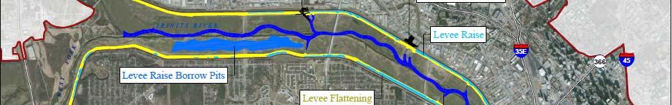
7 Flood Risk Management (FRM) 4 Main Elements Levee raise AT&SF Bridge modification Levee flattening Nonstructural flood control improvements 7
8 FRM: Levee Raise 1500-year Flood Existing Levee Elevation Trinity Parkway Flood Protected Elevation year Elevation Same as 1908 flood of record Ground Elevation about May year Flood Elevation June year Flood Elevation Average low flow conditions that stay within the river channel of the Dallas Floodway Elevation
9 FRM: AT&SF Bridge Modification Remove embankments and remaining narrowly spaced wooden piers that block flood flows Retain a 350-foot section of historic wooden trestle associated with the Santa Fe Trestle Trail 9
10 FRM: Levee Flattening Modify the levees to a 4:1 slope Benefits of the shallower slope: safer mower maintenance, and reduced d risk of slides The excavation of material would double as the preliminary excavations for the West Dallas Lake 10
11 FRM: Nonstructural Improvements The City of Dallas currently has a very advanced effective warning system and Emergency Action Plan (EAP) Improved inundation mapping and data sharing can help improve EAP revision and implementation 11
12 Ecosystem Restoration and Recreation Enhancement Balanced Vision Plan Study Ecosystem Restoration and Recreation Enhancements West Dallas Lake Lakes Urban Lake Natural Lake River Relocation and Modification Wetlands Athletic Facilities General Features Interior Drainage Outfall Modifications Able Sump Ponds Marshlands Cypress Ponds Corinth Wetlands Potential Flex Fields Playgrounds River Access Points Parking and Public Roads Lighting Vehicle Access Pedestrian Amenities Restrooms Amphitheaters e Pump Station Outfalls Pressure Sewer Outfalls Recreation and Ecosystem Enhancements 12
13 Ecosystem Restoration and Recreation Enhancement: Lakes The Proposed Action includes three lakes: West Dallas Lake Urban Lake Natural Lake Rendering of rowing on the West Dallas Lake Rendering of Reunion entrance to the promenade and Urban Lake Rendering of view across the Natural Lake 13
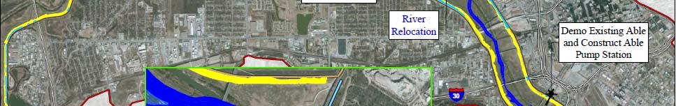
14 Ecosystem Restoration and Recreation Enhancement: River 8 miles of the river channel would be modified River meanders would improve water quality and habitat 14
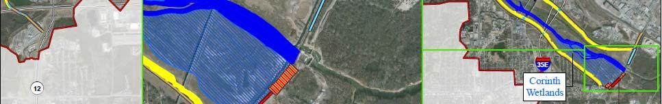
15 Ecosystem Restoration and Recreation Enhancement: Wetlands Rendering of Marshlands alongside Proposed Lake 3 main areas of wetlands: Marshlands Cypress Ponds Corinth Wetlands Rendering of Corinth Wetland 15
16 Ecosystem Restoration and Recreation Enhancement: Recreational Facilities Flex fields and playgrounds River Access Gathering and entertainment Venues Trails 16
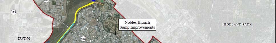
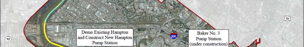
17 Interior Drainage System Improvements Interior Drainage Plan Improvements East Leveeee West Levee Demolish Old Hampton Pump Station Construct New Hampton Pump Station Nobles Branch Sump Improvements Demolish Charlie Pump Station Construct New Charlie Pump Station Rehabilitate Existing Delta Pump Station Construct New Delta Pumping Station Eagle Ford and Trinity-Portland Sump Improvements Construct New Trinity-Portland Pumping Plant 17
18 Alternatives Considered No Action Alternative Alternative 2: Proposed Action with the Parkway Alternative 3: Proposed Action without the Parkway Notable Differences Feature Alternative 2 Alternative 3 Change (from 2 to 3) Bike Path 0 miles 3.4 miles miles Flex Fields 77.8 acres 88.1 acres acres Amphitheaters Meadow 1,259.5 acres 1,230.0 acres acres Park Road 9.6 miles 11.8 miles miles Planter Boxes (raised vegetation) 4.9 acres 14.7 acres acres Secondary Pedestrian Path 17.5 miles 16.9 miles miles Wetlands acres acres acres Parking Area acres acres + 2 acres Number of Access Gateways
19 Cumulative Analysis As part of impact analysis, the Proposed Action is considered on its own, and in concert with other past, present, and reasonably foreseeable future projects. 19
20 Environmental Consequences 20
21 Environmental Consequences 21
22 Environmental Consequences 22
23 Environmental Consequences 23


24 Environmental Consequences Alternative 2 is the U.S. Army Corps of Engineers Preferred Alternative and has preliminarily determined it to be the Least Environmentally Damaging Practicable Alternative. ti 24


25 Recommended Plan Presentation Overview Review Flood Risk Management Plan Results of Comprehensive Analysis Overview of the Recommended Plan in the Draft Feasibility Report Feasibility Report Recommended Plan 25
26 Review of Flood Risk Management Plan U.S. Army Corps of Engineers and City of Dallas utilized an integrated approach for identifying a Flood Risk Management Plan for improving the levee system Utilized results from economic analyses and risk assessment Analyzed both structural and non-structural measures Feasibility Report Recommended Plan 26
27 Flood Risk Management Recommended Plan Identified Three (3) recommended actions: About $10 million dollars total AT&SF Bridge modifications/partial removal Raise the levees to contain a 277,000 cubic feet per second (cfs) flow This flow equates to a 2,500-year flood event Improvements to the City s Emergency Action Plan Feasibility Report Recommended Plan 27
28 Comprehensive Analysis The Water Resources Development Act in 2007 (WRDA 2007) directed the Corps to ensure that the Balanced Vision Plan and Interior Drainage Plan are technically sound and environmentally acceptable Technical soundness is determined by completing comprehensive analysis of hydrology and hydraulics* (H&H), geotechnical and civil design Environmental acceptability is determined by completing National Environmental Policy Act (NEPA) process *H&H analysis determines the amount of runoff, depth, extent, and velocity of the flood waters coming down the river Feasibility Report Recommended Plan 28
29 Comprehensive Analysis Conclusions Trinity Parkway, Balanced Vision Plan (BVP) and Interior Drainage Plan (IDP) features have been determined individually to be technically sound at current level of design Potential negative impacts related to deviations from 1988 Record of Decision (ROD) criteria are insignificant; a variance to ROD is currently proposed With slight modifications of the expected design refinements, all features would function on a comprehensive system wide level from a Corps Civil Works perspective Feasibility Report Recommended Plan 29
30 Recommended Plan WRDA 2007, Section 5141, authorized $459 million total budget for Recommended Plan Includes cost share of 65% federal and 35% non-federal The City can spend a portion of its cost share portion before the Corps begins spending money Feasibility Report Recommended Plan 30
31 Recommended Plan (Alternative 2) The cost share portion of the project cannot exceed the WRDA 2007 authorization of $459 million plus inflation The cost share portion includes flood risk reduction and ecosystem restoration Remaining BVP and IDP projects will be constructed by the City through the Section 408 process Accommodates Trinity Parkway construction by other entity Feasibility Report Recommended Plan 31
32 Recommended Plan (Alternative( 2) FLOOD RISK MANAGEMENT: Levees Raise levee low spots along 9.3 miles of levees to meet 277K flow Low spots to be filled from borrow area of future site of West Dallas Lake Modify AT&SF Bridge 3:1 to 4:1 slopes may be funded by City Interior Drainage Baker Pump Station Able Pump Station Hampton Pump Station ECOSYSTEM RESTORATION: River Relocation Adds meanders back to river Builds habitat pools to improve aquatic diversity Corinth Wetlands Expands existing wetland; Corps participates in excavation and plantings City may construct recreational features such as boardwalks and trails Feasibility Report Recommended Plan 32
33 Recommended Federal Plan (Alternative 2) 33 Feasibility Report Recommended Plan
34 Recommended Plan (Alternative 2) Cost Sharing Summary Total Cost: $529.1 million Federal Cost: $343.9 million Non-Federal Share: $185.2 million 5% cash on Flood Risk Management: $10.4 million Estimated Credit: $115.5 million Lands, Easements, Rights of Ways and Relocations: $59.3 million Bottom line for City: 10.4 million + $59.3 million = $69.7 million still needed Feasibility Report Recommended Plan 34


35 Public Involvement HOW TO PROVIDE COMMENTS The Draft EIS Public Review Period runs from Comments received here were incorporated into the Draft EIS April 18th to June 2. Comments are being taken here in writing and spoken to a recorder. Comments may also be ed or via US Mail. Submit your comments We are here now no later than June 2 nd. For additional information June-Sept on how to comment, visit Final opportunity to the sign in table. comment on the EIS September 2014 This is your best opportunity to be involved December 2014 the in final development of this action! 35
Public Notice. Applicant: City of Dallas Project No.: SWF Date: April 18, Name: Chandler Peter Phone Number:
 Public Notice Applicant: City of Dallas Project No.: SWF- 2014-00151 Date: April 18, 2014 The purpose of this public notice is to inform you of a proposal for work in which you might be interested. It
APPENDIX A HYDROLOGIC AND HYDRAULIC ANALYSIS
 APPENDIX A HYDROLOGIC AND HYDRAULIC ANALYSIS GENERAL The Hydrologic and Hydraulic information presented in this appendix is provided as a supplement to the Dallas Floodway Extension General Re-evaluation
IAFSM 2010 Annual Conference. City of Rockford Keith Creek Greenway Flood Mitigation Project
 IAFSM 2010 Annual Conference City of Rockford Keith Creek Greenway Flood Mitigation Project March 10, 2010 Introduction Problem Overview 1890 s Building of homes along Keith Creek 1920 s Home construction
Lower San Joaquin River Feasibility Study PLAN FORMULATION ADDENDUM
 PLAN FORMULATION ADDENDUM Non-Structural Measure Descriptions Elevate Critical Infrastructure This measure would raise at-risk critical structures above the design inundation level. Elevation would be
Hydrology and Flooding
 Hydrology and Flooding Background The 1996 flood Between February 4, 1996 and February 9, 1996 the Nehalem reporting station received 28.9 inches of rain. Approximately 14 inches fell in one 48 hour period.
UNIVERSITY OF OREGON NORTH CAMPUS CONDITIONAL USE PERMIT PROJECT Draft Conditional Use Permit Stormwater, Sanitary Sewer, and Water Analysis Report
 UNIVERSITY OF OREGON NORTH CAMPUS CONDITIONAL USE PERMIT PROJECT Draft Conditional Use Permit Stormwater, Sanitary Sewer, and Water Analysis Report Prepared for: Cameron McCarthy Landscape Architects LLP
APPENDIX A. Project Scoping
 APPENDIX A Project Scoping Notice of Preparation To: From: Agencies and Interested Parties Paul Brunner, Executive Director, Three Rivers Levee Improvement Authority Date: June 13, 2006 Subject: Notice
Holly Swartz and Jason Shirey
 Chapter 105 General Permits for Stream and Wetland Impacts DEP Ch. 105 CONTACTS FOR BERKS COUNTY: Holly Swartz and Jason Shirey What DEP Regulates Under Chapter 105 Waters of the Commonwealth, which includes
CHAPTER 9 DISCUSSIONS, CONCLUSIONS, AND RECOMMENDATIONS
 CHAPTER 9 DISCUSSIONS, CONCLUSIONS, AND RECOMMENDATIONS This chapter summarizes the results of feasibility level investigations undertaken to identify solutions to the water and related land resource problems
SECTION 7.0 PROJECT FEASIBILITY, ENGINEER S RECOMMENDATION AND DESIGN ISSUES NEEDING RESOLUTION
 SECTION 7.0 PROJECT FEASIBILITY, ENGINEER S RECOMMENDATION AND DESIGN ISSUES NEEDING RESOLUTION 7.1 PROJECT FEASIBILITY The determination of project feasibility is based upon several criteria established
US Army Corps of Engineers
 I I I ' A I US Army Corps of Engineers LA River Ecosystem Restoration, CA Preconstruction Engineering and Design Phase 104791 LOS ANGELES DISTRICT SOUTH PACIFIC DIVISION August 15, 2017 1 Table of Contents
Concept, Feasibility & Mobility Studies. Southport Connector Expressway
 Concept, Feasibility & Mobility Studies Southport Connector Expressway Project Background FDOT Alternative Corridor Evaluation (ACE) Study Advanced Notification Package distributed September 2012 ETDM
Distribution Restriction Statement
 CECW-A Engineer Regulation 1165-2-501 Department of the Army U.S. Army Corps of Engineers Washington, DC 20314-1000 ER 1165-2-501 30 September 1999 Water Resources Policies and Authorities CIVIL WORKS
Hydrologic and Ecologic Impacts from the CERP Indian River Lagoon South Project
 Hydrologic and Ecologic Impacts from the CERP Indian River Lagoon South Project Dr. Gretchen Ehlinger Senior Biologist US Army Corps of Engineers Jacksonville District November 15, 2016 AWRA Conference
PREFACE PREFACE. Red Rock. Project. Master Plan Project. Master Plan 2015
 PREFACE The Lake is a vital tool for the responsible stewardship of resources to benefit present and future generations. The provides guidance and includes direction for appropriate management, use, development,
U.S. Army Corps of Engineers Permit Application Tips
 U.S. Army Corps of Engineers Permit Application Tips MnDOT Environmental Conference Ben Orne and Sarah Wingert, USACE 4-29-2015 US Army Corps of Engineers BUILDING STRONG Outline Introduction to Corps
SEATTLE DISTRICT CIVIL WORKS PROGRAM
 SEATTLE DISTRICT CIVIL WORKS PROGRAM Contents 04 Continuing Authorities Program 05 Section 14 Emergency Streambank Protection Section 103 Beach Protection Section 111 Mitigation of Shore Damage 06 Section
SECTION 11: REGULATORY FLOODWAYS
 SECTION 11: REGULATORY FLOODWAYS Contents 11.1. The Floodway... 11-2 11.1.1. The floodway concept... 11-2 11.1.2. Floodway map... 11-2 11.1.3. Floodway permitting... 11-3 11.1.4. Changing the floodway...
Fargo-Moorhead Metropolitan Area Flood Risk Management Project
 Fargo-Moorhead Metropolitan Area Flood Risk Management Project 52ND ANNUAL IOWA ASCE ENVIRONMENTAL & WATER RESOURCES CONFERENCE 03 April 2014 Aaron W. Buesing Senior Hydraulic Engineer Corps of Engineers,
Will be modified map from GIS 6/16 EOD
 Middle-Snake-Tamarac Rivers Watershed District Judicial Ditch #19 Watershed Regional Conservation Partnership Program (RCPP) Public Scoping Meeting September 26, 2016 Will be modified map from GIS 6/16
Marysville Levee Commission
 Marysville Levee Commission Outline CVFPP Goals & Objectives Highlights of Draft Feather River RFMP Integration between Flood Protection, Agriculture and Wildlife and Floodplain Uses Proposed Projects
US Army Corps of Engineers
 US Army Corps of Engineers Roles and Responsibilities in the BDCP 13 August 2009 USACE Roles in the Federal Family Slide 2 Primary USACE Responsibilities with BDCP Regulatory Program Protect the nation
Atlantic Coast of New York East Rockaway Inlet to Rockaway Inlet and Jamaica Bay, NY
 Atlantic Coast of New York East Rockaway Inlet to Rockaway Inlet and Jamaica Bay, NY Draft Reformulation Public Information October 2016 US Army Corps of Engineers Presentation Outline Project Overview
REVIEW PLAN. Trinity Parkway, City of Dallas, Texas Section 408 Submittal. Ft. Worth District
 REVIEW PLAN Trinity Parkway, City of Dallas, Texas Section 408 Submittal Ft. Worth District MSC Approval Date: 17 June 2015 Last Revision Date: 11 June 2015 REVIEW PLAN Trinity Parkway, City of Dallas,
RIVERSIDE OXBOW FORT WORTH, TEXAS CHAPTER 3 IDENTIFICATION OF PROBLEMS AND OPPORTUNITIES
 RIVERSIDE OXBOW FORT WORTH, TEXAS CHAPTER 3 IDENTIFICATION OF PROBLEMS AND OPPORTUNITIES Regular study team meetings were held with the Tarrant Regional Water District, the USFWS, Streams and Valleys,
Notice No Closing Date: May 12, 2017
 Public Notice U.S. Army Corps of Engineers Pittsburgh District In Reply Refer to Notice No. below US Army Corps of Engineers, Pittsburgh District 1000 Liberty Avenue Pittsburgh, PA 15222-4186 Application
WATERSHED MANAGEMENT INITIATIVE: GOALS & IMPLEMENTATION OBJECTIVES, JULY 26, 1999
 WATERSHED MANAGEMENT INITIATIVE: GOALS & IMPLEMENTATION OBJECTIVES, JULY 26, 1999 The following table indicates the draft goals and objectives for the Santa Clara Basin WMI process. The overall objectives
Santa Clara River Watershed Feasibility Study. Information Meeting City of Santa Clarita August 16, 2007
 Santa Clara River Watershed Feasibility Study Information Meeting City of Santa Clarita August 16, 2007 Darrell Buxton Los Angeles District U.S. Army Corps of Engineers Public Issues and Concerns Balance
LOWER BOISE RIVER INTERIM FEASIBILITY STUDY
 LOWER BOISE RIVER INTERIM FEASIBILITY STUDY Public Information Meetings June 29, 2010 June 30, 2010 July 1, 2010 US Army Corps of Engineers BUILDING STRONG Agenda Introductions / Meeting Objectives Greg
Greenfield Pond B Rehabilitation
 Preliminary Investigation Report Centennial, Colorado November 15, 2011 Prepared for: Liverpool Metropolitan District Prepared by: Stantec Consulting Services, Inc. Table of Contents Executive Summary...
NOTICE OF PREPARATION
 NOTICE OF PREPARATION Date: June 12, 2014 To: From: Subject: Governor s Office of Planning and Research/State Clearinghouse Unit, Responsible Agencies, Trustee Agencies, and Interested Parties Announcement
Blanche Park Reservoir Decision Notice and Finding of No Significant Impact
 Blanche Park Reservoir Decision Notice and Finding of No Significant Impact U.S. Forest Service Grand Mesa, Uncompahgre, and Gunnison National Forests Delta County, Colorado INTRODUCTION The Grand Mesa
Phase II Report on Hydrology, Hydraulics, and Low Water Dams
 Phase II Report on Hydrology, Hydraulics, and Low Water Dams Arkansas River Corridor Tulsa, OK May 2005 Submitted To: U. S. Army Corps of Engineers Tulsa District Prepared by: The GUERNSEY Team 5555 N.
New Castle County, DE. Floodplain Regulations
 New Castle County, DE Floodplain Regulations John J. Gysling, PE CFM Department of Land Use New Castle County, DE February 26, 2009 Today s Presentation Floodplain Protection and Uses Terms and Definitions
CHAPTER 7. San Dieguito River Flooding Adaptation
 CHAPTER 7 San Dieguito River Flooding Adaptation This chapter includes a range of adaptation measures to address vulnerabilities from flooding along the San Dieguito River, including the river valley,
PRESENTERS. Contact Information: RW Armstrong Union Station, 300 S. Meridian St. Indianapolis, IN
 1 PRESENTERS David Bourff, Director of Environmental Planning Simon Davies, LEED AP, Environmental Scientist Summer O Brien, PWS, Senior Environmental Scientist Contact Information: RW Armstrong Union
Freight Street Development Strategy
 Freight Street Development Strategy Appendix B: Naugatuck River Floodplain Analysis Freight Street Development Strategy DECEMBER 2017 Page B-1 1.0 NAUGATUCK RIVER FLOODPLAIN AT FREIGHT STREET 1.1 Watershed
J O I N T P U B L I C N O T I C E
 DEPARTMENT OF THE ARMY U.S. ARMY CORPS OF ENGINEERS, SAVANNAH DISTRICT 100 W. OGLETHORPE AVENUE SAVANNAH, GEORGIA 31401-3604 J O I N T P U B L I C N O T I C E CHARLESTON AND SAVANNAH DISTRICTS- US ARMY
Environmental Information Worksheet
 Environmental Information Worksheet Water System Owner (Attach additional sheets if necessary) Needs and Alternatives Provide a brief narrative that describes: Current drinking water system needs. Project
Port of Camas/Washougal Levee Recertification and Engineering Analysis Request for Proposal May 3, 2011
 I. Project Summary As part of their Map Modernization Program, FEMA has initiated a countywide Flood Insurance Study (FIS) and Digital Flood Insurance Rate Map (DFIRM) for the Port of Camas/Washougal.
Sovereign Lands and Great Salt Lake
 Sovereign Lands and Great Salt Lake The Living Lake - Charles Uibel Laura Ault Sovereign Lands Program Manager Division of Forestry, Fire and State Lands What are Sovereign Lands? Lakebeds and riverbeds
Chapter 11 Culverts and Bridges
 Chapter 11 Culverts and Bridges Contents 1.0 Introduction... 1 2.0 General Design... 1 2.1 Design Criteria... 1 2.2 Design Flows... 1 2.3 Permitting and Regulations... 1 2.4 Aesthetics and Safety... 2
LOWER CACHE CREEK, YOLO COUNTY WOODLAND AREA FEASIBILITY STUDY
 Background LOWER CACHE CREEK, YOLO COUNTY WOODLAND AREA FEASIBILITY STUDY Energy and Water Development Appropriations Act of 1993 Reconnaissance Study completed June 1994 Feasibility Cost Share Agreement
PUBLIC NOTICE LOS ANGELES DISTRICT. APPLICATION FOR PERMIT Port of Los Angeles Berths : Wilmington Waterfront Promenade
 PUBLIC NOTICE U.S. ARMY CORPS OF ENGINEERS LOS ANGELES DISTRICT BUILDING STRONG APPLICATION FOR PERMIT Port of Los Angeles Berths 182-186: Wilmington Waterfront Promenade Public Notice/Application No.:
Environmental Impact Statement (EIS)/ Section 106 Public Meeting Proposed Alternatives. December 14, 2017
/ Section 106 Public Meeting Proposed Alternatives. December 14, 2017") Environmental Impact Statement (EIS)/ Section 106 Public Meeting Proposed Alternatives December 14, 2017 Today s Agenda Project Overview Project Schedule Purpose and Need Concept Screening Process Level
Environmental Impact Statement (EIS)/ Section 106 Public Meeting Proposed Alternatives December 14, 2017 Today s Agenda Project Overview Project Schedule Purpose and Need Concept Screening Process Level
Willamette National Forest McKenzie River Ranger District
 United States Department of Agriculture Forest Service Willamette National Forest McKenzie River Ranger District 57600 McKenzie HWY McKenzie Bridge, OR 97413 File Code: 1950 Date: October 8, 2008 To Interested
Folsom Dam Water Control Manual Update
 Folsom Dam Water Control Manual Update Stakeholder Discussion October 31, 2013 Location: Tsakopoulos Library Galleria, East Room, 828 I Street, Sacramento US Army Corps of Engineers WELCOME & INTRODUCTIONS
FINDINGS: Olsson used a three-step analysis strategy to develop a benefit cost ratio that would indicate the relative feasibility of this project.
 EXECUTIVE SUMMARY FINDINGS: Based on the results of this feasibility study, the Platte Republican Diversion Project would be cost-effective. With minimal improvements to the channel, and the existing bridge
COON CREEK WATERSHED DISTRICT PERMIT REVIEW. Spring Lake Park Schools Westwood Middle School st Avenue NE, Spring Lake Park, MN 55432
 PAN 16-112, Westwood Middle School, Page 1 of 6 COON CREEK WATERSHED DISTRICT PERMIT REVIEW MEETING DATE: August 22, 2016 AGENDA NUMBER: 10 FILE NUMBER: 16-112 ITEM: Westwood Middle School RECOMMENDATION:
Chehalis Basin Strategy Programmatic SEPA Draft EIS
 Chehalis Basin Strategy Programmatic SEPA Draft EIS History of Flooding I-5 closed in 1990, 1996, 2007, 2009 Five largest flood events occurred since 1986 2 History of Habitat Degradation Harvest has been
RECORD OF DECISION MAY RIO GRANDE FLOODWAY, SAN ACACIA TO BOSQUE DEL APACHE UNIT FLOOD RISK MANAGEMENT PROJECT SOCORRO COUNTY, NEW MEXICO
 RECORD OF DECISION MAY 2 0 2014 RIO GRANDE FLOODWAY, SAN ACACIA TO BOSQUE DEL APACHE UNIT FLOOD RISK MANAGEMENT PROJECT SOCORRO COUNTY, NEW MEXICO The Final General Reevaluation Report and Supplemental
APPENDIX F. SECTION 404(B)(1) EVALUATION SHORT VERSION. Herbert Hoover Dike Dam Safety Modification Study
(1) EVALUATION SHORT VERSION. Herbert Hoover Dike Dam Safety Modification Study") Appendix F Section 404(b)(1) APPENDI F. SECTION 404(B)(1) EVALUATION SHORT VERSION Herbert Hoover Dike Dam Safety Modification Study HHD Dam Safety Modification Study EIS June 2016 E i Appendix F Section
Appendix F Section 404(b)(1) APPENDI F. SECTION 404(B)(1) EVALUATION SHORT VERSION Herbert Hoover Dike Dam Safety Modification Study HHD Dam Safety Modification Study EIS June 2016 E i Appendix F Section
Appendix D - Evaluation of Interim Solutions
 Appendix D - Evaluation of Interim Solutions D.1 Introduction The implementation of long-term improvements is projected to take 5 to 8 years. To reduce the number of years of flooding impacts, the partner
Agency Scoping Meeting
 Agency Scoping Meeting Dallas Fort Worth Core Express Service Drop-in Public Information Open House Tuesday, June 30, 2015 1 WELCOME AND THANK YOU FOR COMING TODAY 2 Meeting Format Open House 3 Purpose
Community. Restoration. Prevention.
 Community. Restoration. Prevention. Truckee Wetlands Restoration Project Thank you to our Funders Donors to the OUR VALUES PARTNERSHIPS ECOLOGICALLY SOUND ECONOMICS Truckee River Watershed Council May
PUBLIC NOTICE. Section 404 of the Clean Water Act (33 U.S.C. 1344) Section 10 of the Rivers and Harbors Act of 1899 (33 U.S.C.
 Section 10 of the Rivers and Harbors Act of 1899 (33 U.S.C.") US Army Corps Of Engineers Wilmington District PUBLIC NOTICE Issue Date: June 17, 2014 Comment Deadline: July 17, 2014 Corps Action ID#: SAW-2009-00655 NC DOT TIP: R-4903 The Wilmington District, Corps
US Army Corps Of Engineers Wilmington District PUBLIC NOTICE Issue Date: June 17, 2014 Comment Deadline: July 17, 2014 Corps Action ID#: SAW-2009-00655 NC DOT TIP: R-4903 The Wilmington District, Corps
City of Katy Flood Protection Study (Meeting 3 of 3) October 23, 2017
 October 23, 2017") City of Katy Flood Protection Study (Meeting 3 of 3) October 23, 2017 Phasing of Meetings April Meeting May Meeting October Review of Tax Day Storm Event and Immediate Actions Taken By City Review of Coordination
City of Katy Flood Protection Study (Meeting 3 of 3) October 23, 2017 Phasing of Meetings April Meeting May Meeting October Review of Tax Day Storm Event and Immediate Actions Taken By City Review of Coordination
Project Goals and Scoping
 Prepared for: Boulder County, Colorado Flood Planning & Preliminary Design Services for South St. Vrain Creek Restoration at Hall Ranch and Scoping May 24, 2016 Meeting with General Public In association
Outcomes. Kelly Karll-SEMCOG Margaret Barondess - MDOT
 Eco-Logical: I-75 Corridor I-75 Conservation Transportation Action Planning in to Monroe Achieve County: Multiple Stormwater Environmental Considerations Outcomes Kelly Karll-SEMCOG Karll@semcog.org Margaret
U. S. Army Corps of Engineers Charleston District Overview
 U. S. Army Corps of Engineers Charleston District Overview Diane C. Perkins, AICP Charleston District Chief, Planning & Environmental Branch Diane.Perkins@usace.army.mil US Army Corps of Engineers General
STREAM RESTORATION PURPOSE, PRACTICE, AND METHODS. By Marcus Rubenstein, CPESC
 STREAM RESTORATION PURPOSE, PRACTICE, AND METHODS By Marcus Rubenstein, CPESC WHAT IS STREAM RESTORATION? The return of a stream s lost natural functions, usually resulting from watershed alterations,
Municipal Stormwater Management Planning
 Municipal Stormwater Management Planning Christopher C. Obropta, Ph.D., P.E. Water Resources Extension Specialist with Rutgers Cooperative Extension Assistant Professor with Department of Environmental
Stormwater Management Studies PDS Engineering Services Division ES Policy # 3-01
 Stormwater Management Studies PDS Engineering Services Division Revised Date: 2/28/08 INTRODUCTION The City of Overland Park requires submission of a stormwater management study as part of the development
US Army Corps of Engineers and Stream Restoration Permitting
 US Army Corps of Engineers and Stream Restoration Permitting Jack Dinne US Army Corps of Engineers-Baltimore Maryland Section Northern May 6, 2014 US Army Corps of Engineers Presentation Overview Corps
Municipal Class Environmental Assessment for Pottersburg Creek Slope Stability Study South of Hamilton Road, Schedule B
 Municipal Class Environmental Assessment for Pottersburg Creek Slope Stability Study South of Hamilton Road, Schedule B February 13, 2013 Municipal Class EA Process We are here Purpose and Objective of
Detailed Project Report Menomonee River Section 206 Milwaukee, WI June 2014
 Executive Summary Main Report Appendix A Engineering Appendix B Hydraulics & Hydrology Appendix C Cost Appendix D Economics Detailed Project Report Menomonee River Section 206 Milwaukee, WI June 2014 Appendix
SOUTH FLORIDA WATER MANAGEMENT DISTRICT. Question 13: Wetlands
 SOUTH FLORIDA WATER MANAGEMENT DISTRICT Question 13: Wetlands 1. The wetland responses and topographical data provided in the ADA for the 520- acre project site are conceptual in nature. The referenced
Poly Met Mining, Inc. Antidegradation Review - Preliminary Determination for 401 Certification
 Poly Met Mining, Inc. Antidegradation Review - Preliminary Determination for 401 Certification Summary Poly Met Mining, Inc. (PolyMet) submitted an application for a Clean Water Act Section 401 Water Quality
Adjusted Flood Prone Acres
 Adjusted Flood Prone Acres The flood prone area is defined as the area adjacent to the stream that is innundated or saturated when the elevation of the water is at twice the maximum depth at bankfull stage
Constructed Wetland Pond T-8
 Constructed Wetland Pond T-8 Description A constructed wetlands pond is a shallow retention pond designed to permit the growth of wetland plants such as rushes, willows, and cattails. Constructed wetlands
South St. Vrain / Hall Meadows Restoration Planning August 20, 2015
 South St. Vrain / Hall Meadows Restoration Planning August 20, 2015 Agenda Introductions Purpose & Goals of Meeting Planning Area Master Plan Restoration Planning: Cost Estimates, Grants, Scope, Timeline
SW-74 SERENOVA PRESERVE SITES 2, 3, 4, 8 MITIGATION PLAN
 SW-74 SERENOVA PRESERVE SITES 2, 3, 4, 8 MITIGATION PLAN BACKGROUND INFORMATION Project SWIM? Aquatic Control? Exotic Control? Mitigation Bank? Type No No No No Mitigation Restoration and enhancement Type
Doyle Park Reconstruction Project Improving Flood Control Facilities to Meet a TMDL
 Doyle Park Reconstruction Project Improving Flood Control Facilities to Meet a TMDL Ann Arbor, Michigan Washtenaw County Drain Commissioner & Malletts Creek Coordinating Committee November, 2007 Janis
MSD Integrated Watershed Management Planning Approach to Achieve Sustainable Communities
 MSD Integrated Watershed Management Planning Approach to Achieve Sustainable Communities MaryLynn Lodor MSD of Greater Cincinnati Sharon Jean-Baptiste CH2M HILL April 4, 2013 Overview MSD s Environmental
Northern Intermodal Transit Facility WHAT IS AN INTERMODAL TRANSIT FACILITY?
 WHAT IS AN INTERMODAL TRANSIT FACILITY? An intermodal transit facility gathers many modes of transportation together and is strategically located to increase destination alternatives. Intermodal facilities
WETLANDS AND OPEN WATERS Compensatory Mitigation Definitions of Factors
 Adverse effects as used in this section of the SOP means any adverse ecological effect on wetlands or areas of open water. Those effects, or impacts, include filling, excavating, flooding, draining, clearing,
INFLOW DESIGN FLOOD CONTROL SYSTEM PLAN PLANT BARRY ASH POND ALABAMA POWER COMPANY
 INFLOW DESIGN FLOOD CONTROL SYSTEM PLAN PLANT BARRY ASH POND ALABAMA POWER COMPANY Section 257.82 of EPA s regulations requires the owner or operator of an existing or new CCR surface impoundment or any
Appendix J Hydrology and Hydraulics
 Appendix J Hydrology and Hydraulics Marsh Lake Dam Ecosystems Restoration Feasibility Study Hydraulics & Hydrology Appendix January 2011 Contents List of Figures iii List of Tables iii I. General 1 II.
Ingham County Drain Commissioner Patrick E. Lindemann 707 BUHL AVENUE P. O. BOX 220 MASON MI PH. (517) FAX (517)
 FAX (517)") Date Issued Ingham County Drain Commissioner Patrick E. Lindemann 707 BUHL AVENUE P. O. BOX 220 MASON MI 48854 PH. (517) 676-8395 FAX (517) 676-8364 APPLICATION FOR SOIL EROSION AND SEDIMENTATION POLLUTION
Date Issued Ingham County Drain Commissioner Patrick E. Lindemann 707 BUHL AVENUE P. O. BOX 220 MASON MI 48854 PH. (517) 676-8395 FAX (517) 676-8364 APPLICATION FOR SOIL EROSION AND SEDIMENTATION POLLUTION
Public Notice ISSUED: March 14, 2018 EXPIRES: April 13, 2018
 APPLICANT: REFER TO: Wellington Management, Inc. 2004-04510-BBY Public Notice ISSUED: March 14, 2018 EXPIRES: April 13, 2018 SECTION:404 - Clean Water Act 1. APPLICATION FOR PERMIT TO discharge fill material
HUNTING BAYOU FLOOD RISK MANAGEMENT, HARRIS COUNTY, TEXAS DRAFT GENERAL REEVALUATION REPORT AND INTEGRATED ENVIRONMENTAL ASSESSMENT
 HUNTING BAYOU FLOOD RISK MANAGEMENT, HARRIS COUNTY, TEXAS DRAFT GENERAL REEVALUATION REPORT AND INTEGRATED ENVIRONMENTAL ASSESSMENT APPENDIX 4 COST ESTIMATES June 2014 HARRIS COUNTY FLOOD CONTROL DISTRICT
APPENDIX H Guidance for Preparing/Reviewing CEQA Initial Studies and Environmental Impact Reports
 APPENDIX H H.1 Guidance for Preparing and Reviewing CEQA Initial Studies Step 1: Consider the Project Characteristics as Provided by the Project Applicant Review the project application and draft plan
PUBLIC NOTICE. REPLY TO: Denver Regulatory Office 9307 South Wadsworth Blvd 30 DAY NOTICE Littleton, CO FAX (303)
") PUBLIC NOTICE US Army Corps of Engineers Omaha District Application No: NWO-2017-01366-DEN Project: Douglas Lane Tributary Stabilization Project Applicant: Town of Castle Rock Waterway: Douglas Lane Tributary
PUBLIC NOTICE US Army Corps of Engineers Omaha District Application No: NWO-2017-01366-DEN Project: Douglas Lane Tributary Stabilization Project Applicant: Town of Castle Rock Waterway: Douglas Lane Tributary
Requirements and Considerations for Non- Residential Floodproofing ASFPM 2014
 Requirements and Considerations for Non- Residential Floodproofing ASFPM 2014 1.1 Damage to Non-Residential Buildings High-Rise Building in Lower Manhattan with 4 feet of water on First Floor Requirements
Coastal Texas Protection and Restoration Project
 Coastal Texas Protection and Restoration Project Sharon Tirpak / Sheridan Willey / Janelle Stokes Project Management / Planning / Environmental USACE, Galveston District August 2014 US Army Corps of Engineers
DRAFT. Jacob Torres, P.E.; Nick Fang, Ph.D., P.E.
 \ Memorandum SSPEED Center at Rice University Department of Civil & Environmental Engineering 6100 Main MS-317 Houston, Texas 77005-1827 sspeed.rice.edu tel: 713-348-4977 To Andy Yung, P.E. CFM; Lane Lease,
Solano Multi-Species Habitat Conservation Plan
 Solano Multi-Species Habitat Conservation Plan 580,000 Acres 37 Covered Species 4 Natural Communities 12,000 acres of Proposed Development Approximately 23,000 acres will be Preserved Plan Participants
Initial Application of a Landscape Evolution Model to a Louisiana Wetland
 Initial Application of a Landscape Evolution Model to a Louisiana Wetland by Carl F. Cerco PURPOSE: Corps planning projects encompass a wide variety of restoration goals. These include wetland restoration,
UPPER MISSISSIPPI RIVER COMPREHENSIVE PLAN
 UPPER MISSISSIPPI RIVER COMPREHENSIVE PLAN APPENDIX D COST ESTIMATES Prepared by the U.S. Army Corps of Engineers Rock Island, St. Louis, and St. Paul Districts March 2008 UPPER MISSISSIPPI RIVER COMPREHENSIVE
LITTLE ROCK DISTRICT CORPS OF ENGINEERS WATER SUPPLY
 US Army Corps of Engineers LITTLE ROCK DISTRICT CORPS OF ENGINEERS WATER SUPPLY One Corps Serving The Army and the Nation Storage at Existing Lakes Basic Authority Water Supply Act of 1958 The Corps can
REQUEST FOR STATEMENT OF QUALIFICATIONS SOQ #
 REQUEST FOR STATEMENT OF QUALIFICATIONS SOQ #2018-010 for PROFESSIONAL SERVICES Architectural, Landscape Architectural, Appraisal, Title, Engineering and Survey FY 2018 Issue date: January 25, 2018 Lake
HEC-RAS 2D Modeling in Support of Ascension Parish Levee Certification
 HEC-RAS 2D Modeling in Support of Ascension Parish Levee Certification OFMA 2017 Annual Conference September 19, 2017 Presented by: Jeff Doudrick, PE, ENV SP Project Manager HNTB Corporation Agenda Project
SAN FRANCISCO DISTRICT
 LETTER REPORT SAN FRANCISCO BAY SHORELINE STUDY U.S. ARMY CORPS OF ENGINEERS SAN FRANCISCO DISTRICT,APRIL 1992 LETTER REPORT SAN FRANCISCO BAY SHORELINE STUDY U.S. ARMY CORPS OF ENGINEERS SAN FRANCISCO
Public Notice. Applicant: Lennar Homes Project No.: SWF Date: October 29, Name: Mr. Darvin Messer Phone Number:
 Public Notice Applicant: Lennar Homes Project No.: SWF-2013-00265 Date: October 29, 2013 The purpose of this public notice is to inform you of a proposal for work in which you might be interested. It is
POLICY FOR NATURAL RESOURCE MANAGEMENT AREAS
 POLICY FOR NATURAL RESOURCE MANAGEMENT AREAS I. POLICY STATEMENT Auburn University's (the University's) "Policy for Natural Resource Management Areas" implements the Campus Master Plan Land Use Element
KRISTOPHER J. KRZYSTON, CEI, CEM
 PERMITTING IN NEW JERSEY KRISTOPHER J. KRZYSTON, CEI, CEM Kristopher J. Krzyston Rutgers graduate 1994 B.S. Environmental Planning Certificate in G.I.S. Assistant Division Manager Environmental Science
15A NCAC 07H.0209 COASTAL SHORELINES (a) Description. The Coastal Shorelines category includes estuarine shorelines and public trust shorelines.
 Description. The Coastal Shorelines category includes estuarine shorelines and public trust shorelines.") 15A NCAC 07H.0209 COASTAL SHORELINES (a) Description. The Coastal Shorelines category includes estuarine shorelines and public trust shorelines. Estuarine shorelines AEC are those non-ocean shorelines
15A NCAC 07H.0209 COASTAL SHORELINES (a) Description. The Coastal Shorelines category includes estuarine shorelines and public trust shorelines. Estuarine shorelines AEC are those non-ocean shorelines
PUBLIC NOTICE. Dredging with ten-years maintenance, return flow to the waterway and upland placement. Georgica Cove, tributary of Georgica Pond
 PUBLIC NOTICE US Army Corps of Engineers New York District Jacob K. Javits Federal Building New York, N.Y. 10278-0090 ATIN: Regulatory Branch In replying refer to: Public Notice Number: NAN-2016-01054-EHA