Groundwater in Bayfield County. Madeline Gotkowitz Hydrogeologist April 23, 2015
|
|
|
- Hilary Sims
- 6 years ago
- Views:
Transcription

1 Groundwater in Bayfield County Madeline Gotowitz Hydrogeologist April 23, 2015
2 Groundwater in Bayfield County Groundwater basics Hydrogeology across Wisconsin Hydrogeology in Bayfield County Mapping groundwater features

3 Wisconsin s Water Cycle


4 Groundwater discharge to Honey Cree is baseflow


5 Hydrogeology: Groundwater flows through roc and sediment Water under the ground, within an aquifer; porous sand, gravel and roc holds water
6
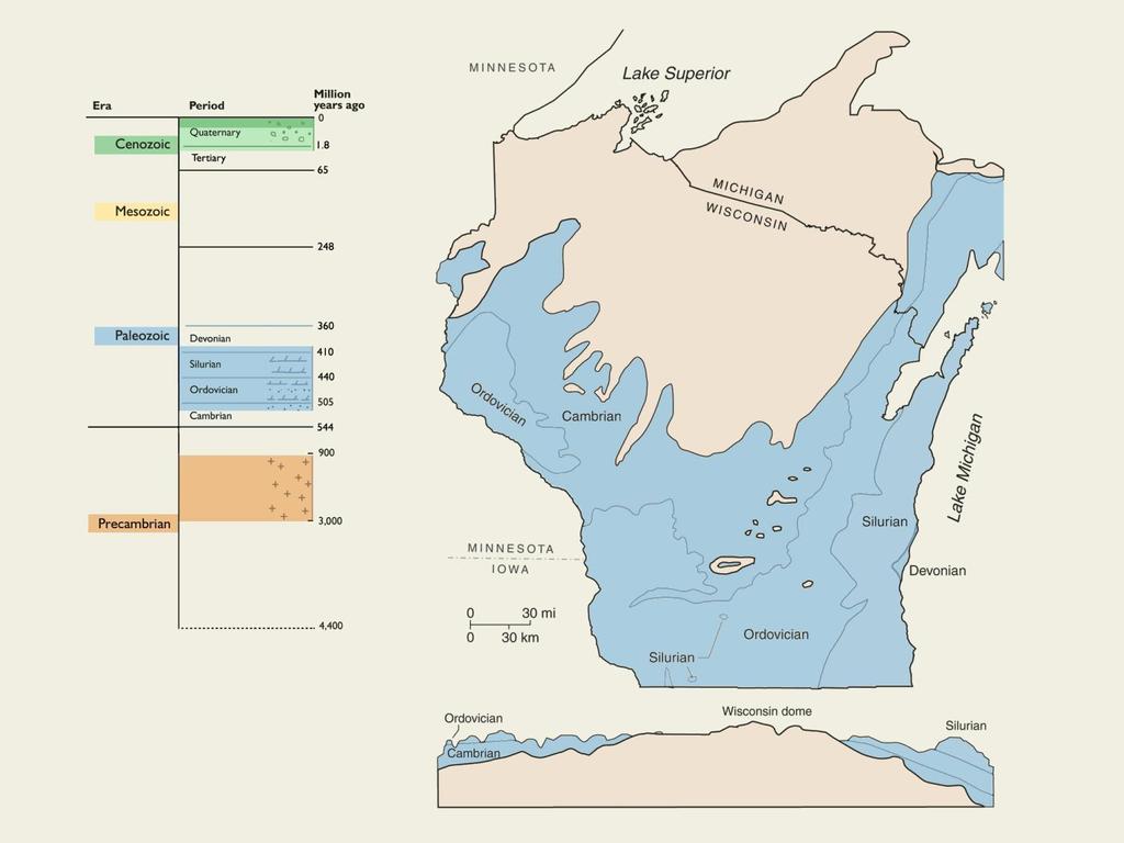
7 Groundwater in dolomite and Distribution limestone of carbonate is vulnerable roc to contamination. Legend Silurian Su dolomite Sinnipee Os dolomite Prairie Opc du Chien dolomite
8 Bedroc within 50 feet of surface
9 Distribution of carbonate roc within 50 feet of surface

10 Calumet and Brown Counties


11 Wisconsin s groundwater contamination issues are significant The left jar contains brown water contaminated by manure. Both samples are from the same well.


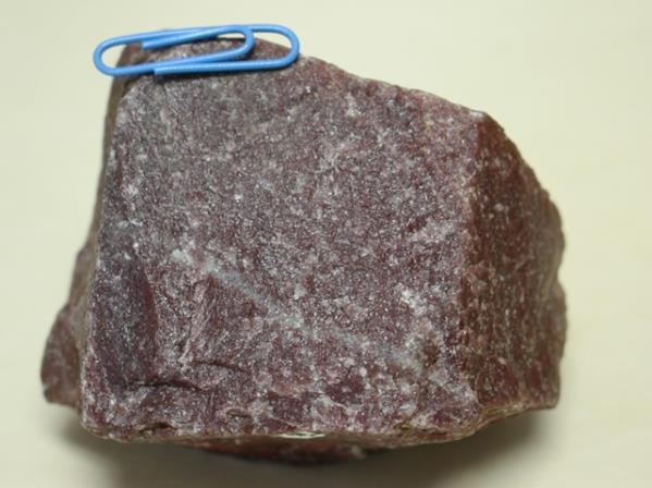
12 Karst features can be easy to see Sinnipee Dolomite: Dane and Iowa Counties
13 Hydrogeology in Bayfield County

14 Courtesy of USGS Hydrogeologic cross-section

15 Glacial geologic formations sandy till Courtesy of USGS

16 Thicness of glacial deposits Courtesy of USGS
17 Glacial geology

18 Bedroc Geology Chequamegon Sandstone Freda Sandstone volcanics

19 Orienta Sandstone Amnicon Falls State Par Photo: E. Stewart, WGNHS


20 Wisconsin Groundwater Susceptibility Map Depth to bedroc, bedroc type, depth to water table, surficial geology, soil type

21 Wisconsin Groundwater Susceptibility Map Depth to bedroc, bedroc type, depth to water table, surficial geology, soil type

22 Example groundwater study Town of Byron Fond du Lac County

23 Depth to bedroc Town of Byron - Example

24 Water table elevation Town of Byron - Example


25 Groundwater recharge Town of Byron - Example Estimate accounts for: - Historical climate data - Soil moisture capacity - Soil type - land-use type


26 Groundwater contaminant susceptibility Combination of factors - Depth to bedroc - Bedroc type - Depth to water table - Recharge rate Town of Byron - Example

27 Hydrogeologic cross sections Town of Byron - Example
28 Nitrate, mg/l NO Iowa County Groundwater: susceptibility versus contamination Susceptibility Least susceptible Moderately susceptible Highly susceptible Most susceptible Nitrate, mg/l NO wells tested 14 % > 10 mg/l NO 3 46 % > 2 mg/l NO 3 Data from Central Wisconsin Groundwater Center and UW Extension.
29 Next steps: questions and discussion Groundwater susceptibility map requires: Collect, compile and analyze data: Depth to the water table Depth to bedroc Glacial deposits (sandy till versus clay till) Bedroc type (sandstone or basalt) Map of groundwater recharge rates Alternative: Develop hydrogeologic cross sections in ag-dominated areas to illustrate wells, groundwater and surface water in areas of interest Facilitate use of this information through educational and outreach efforts in Bayfield County
30

31 The Decorah-Platteville aquitard separates the shallow Galena aquifer from the deep aquifer. springs and streams Springs may develop along valley wall at times of high water table.

32 In upland areas, multi-aquifer wells can provide a pathway for groundwater to flow from the shallow to the deep aquifer. shallow well deep well multi-aquifer well water table potentiometric surface Aquitard Deep aquifer


33 Groundwater flows from high to low elevations. One use of the water table map is to identify where groundwater comes from that flows to a well or stream.
34 Groundwater recharge rates are high in Iowa County, due to permeable soil, and forest and agricultural land use. Infiltration, in an average year Infiltration, in an average year medium (6-9 inches/year) high (9-11 inches/year) medium (6-9 inches/year) high (9-11 inches/year) very high (> 11 inches/year) very high (> 11 inches/year) not defined (wetland or water) Miles Miles Does this mean that there is an unlimited supply of water? Ü 34

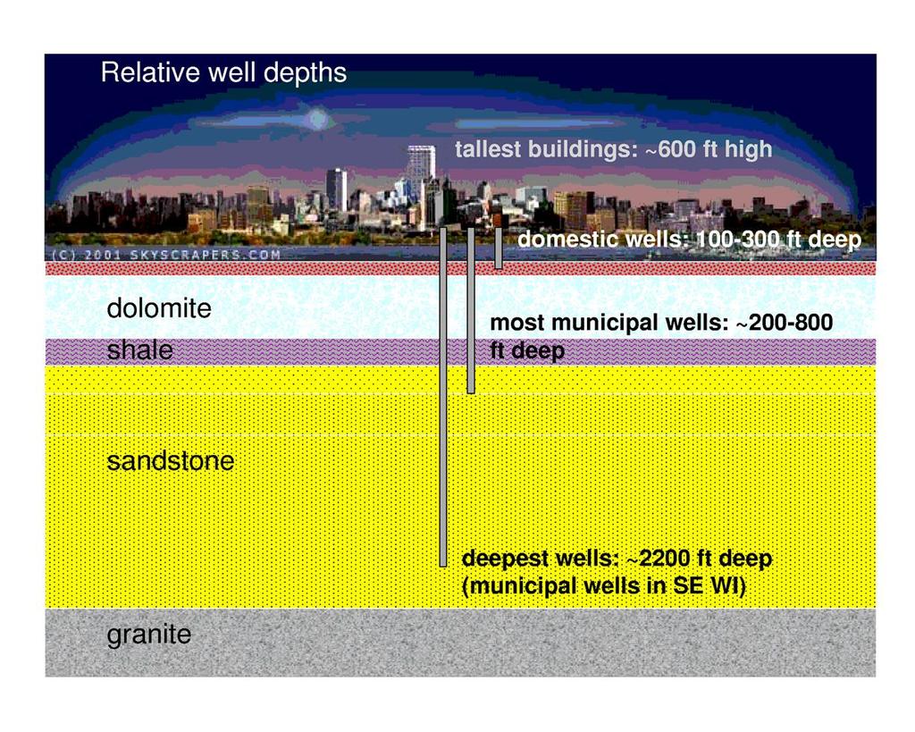
35 Lots of wells near one stream are lie too many straws in the glass Source: R. Smail, Wisconsin DNR

36 How do we use our groundwater? 2012 Wisconsin Withdrawls Agricultural irrigation surpassed municipal public water in 2012 due to the drought Groundwater pumping is about 760 million gallons per day Could cover the land area of Wisconsin with ¼ inch of water Source: R. Smail, Wisconsin DNR Enough water to fill Lambeau Field over 600 times Is that a lot of water? Is it too much?

37 Sinhole in SE Wisconsin

38 Perched groundwater in the Driftless Area, which has extensive aquitards. aquitard Perched aquifer Deep aquifer

39 How much recharge do we get? Hart et al., 2012 On average, about 8 to 10 inches per year in Dane County, WIsconsin Approximately 28,000 million gallons per day in Wisconsin We pump about 760 million gallons per day


40 Where does well water come from? 40


41 Pumping reduces discharge Citizens Natural Resources Association of Wisconsin & Trout Unlimited at the Mecan River from Alley, Reilly, and Frane, USGS Circular 1186, 1999

42 Precambrian roc Fractured Low well yield 42

43 Sandstone aquifer Sandstone and dolomite Extensive and thic Very porous- great storage Yields prolific water to wells 43

44 Dolomite aquifer: Shallow bedroc Lots of fractures Vulnerable to contamination 44


45 Dolomite and limestone are easily dissolved Caves, sinholes and fractures are common in this roc. Contaminants reach groundwater quicly


46 Pine Lae, Waushara County Photos courtesy of G. Kraft, UW Extension Tributary of Tenmile Cree Adams County, WI 2013
47
STRAWMAN OUTLINE March 21, 2008 ISWS/ISGS REPORT ON THE OPPORTUNITIES AND CHALLENGES OF MEETING WATER DEMAND IN NORTH-EAST ILLINOIS
 STRAWMAN OUTLINE March 21, 2008 ISWS/ISGS REPORT ON THE OPPORTUNITIES AND CHALLENGES OF MEETING WATER DEMAND IN NORTH-EAST ILLINOIS REPORT TO BE DELIVERED TO THE RWSPG BY SEPTEMBER 30, 2008 Table of Contents
Water and Wisconsin Agriculture: Reducing Withdrawals and Increasing Efficiency
 Water and Wisconsin Agriculture: Reducing Withdrawals and Increasing Efficiency Bob Smail Water Use Section Wisconsin DNR Presented March 11, 2014 Wisconsin Land and Water Conservation Association Meeting
Aquifer Characterization and Drought Assessment Ocheyedan River Alluvial Aquifer
 Aquifer Characterization and Drought Assessment Ocheyedan River Alluvial Aquifer Iowa Geological Survey Water Resources Investigation Report 10 Aquifer Characterization and Drought Assessment Ocheyedan
GROUNDWATER DISCHARGE
 GROUNDWATER DISCHARGE C O N N E C T I O N F A C T S H E E T S E R I E S D I S C H A R G E : The movement of groundwater from the subsurface to the surface P E R M E A B I L I T Y : The ability of a material
Karst Spring: Generalized Monitoring Strategy
 General Hydrologic Characteristics of Karst Springs Karst spring means a location of concentrated groundwater discharge from conduits in bedrock (predominantly solution enhanced conduits or zones in carbonate
Occurrence of Iron in Surface Waters of the Upper St. Johns River Basin
 Occurrence of Iron in Surface Waters of the Upper St. Johns River Basin Prepared by Florida Department of Environmental Protection Bureau of Watershed Management Ground Water Protection Section December
Background Information on the. Peace River Basin
 Background Information on the Peace River Basin Resource Conservation & Development Department August 24 Background Physiography The Peace River drainage basin occupies large parts of Polk, Hardee, DeSoto,
Groundwater. Groundwater Movement. Groundwater Movement Recharge: the infiltration of water into any subsurface formation.
 On March 22, 2014, a major landslide occurred near Oso, Washington. Death toll currently at 30, with 15 still missing. Groundwater Before and After Swipe http://bit.ly/pen1jt N. Fork Stillaguamish River
4.0 Procedures And Layer Descriptions:
 4.0 Procedures And Layer Descriptions: The complexity of the hydrogeology in the Middle and Upper Roaring Fork study area and the disparity in type, distribution and accuracy of available data do not support
Addressing Groundwater Quality in Karst Regions
 Addressing Groundwater Quality in Karst Regions Davina Bonness County Conservationist / Department Head Kewaunee County Land & Water Conservation Department Silurian Dolomite In U.S Silurian Dolomite Aquifer
CHAPTER 13 OUTLINE The Hydrologic Cycle and Groundwater. Hydrologic cycle. Hydrologic cycle cont.
 CHAPTER 13 OUTLINE The Hydrologic Cycle and Groundwater Does not contain complete lecture notes. To be used to help organize lecture notes and home/test studies. Hydrologic cycle The hydrologic cycle is
Groundwater in Iowa County. A Citizen s Guide
 Groundwater in Iowa County A Citizen s Guide Groundwater in Iowa County A Citizens Guide Kevin Masarik Paul Ohlrogge David Mechenich University of Wisconsin-Extension Center for Watershed Science and Education/UW-Stevens
Overview. Students will...
 Overview Students will... Understand the interaction between ground water and surface water. Observe the difference between a permeable layer and an impermeable layer in an aquifer. See how water is stored
AQUIFERS OF THE SAN ANTONIO RIVER BASIN
 AQUIFERS OF THE SAN ANTONIO RIVER BASIN OBJECTIVES Explain what an aquifer is Identify the major aquifers located in the San Antonio River Basin Explain the difference between porosity and permeability
The Ground Water Supply of Southeastern Wisconsin (Will there be enough for the future?)
") The Ground Water Supply of Southeastern Wisconsin (Will there be enough for the future?) Douglas Cherkauer Professor of Hydrogeology Department of Geosciences University of Wisconsin-Milwaukee Topics to
The Ground Water Supply of Southeastern Wisconsin (Will there be enough for the future?) Douglas Cherkauer Professor of Hydrogeology Department of Geosciences University of Wisconsin-Milwaukee Topics to
NATURAL FEATURES, LAND SUITABILITY FOR DEVELOPMENT AND DEVELOPMENT CONCERNS
 East Central Wayne County Comprehensive Plan - Natural Features, Land Suitability Page 170 NATURAL FEATURES, LAND SUITABILITY FOR DEVELOPMENT AND DEVELOPMENT CONCERNS Introduction The residents of East
Water Resources on PEI: an overview and brief discussion of challenges
 Water Resources on PEI: an overview and brief discussion of challenges Components: Components and links Atmospheric water Surface water (including glacial water) Groundwater Links: Precipitation (atm(
RAT MARSH RIVER WATERSHED GROUNDWATER RESOURCE INFORMATION. Groundwater Management Section Manitoba Water Stewardship
 RAT MARSH RIVER WATERSHED GROUNDWATER RESOURCE INFORMATION Prepared by: Laurie Frost Groundwater Management Section Manitoba Water Stewardship January 2012 Page 2 RAT MARSH RIVER WATERSHED GROUNDWATER
Design Guideline for Gravity Systems in Soil Type 1. January 2009
 Design Guideline for Gravity Systems in Soil Type 1 January 2009 This page is intentionally blank. Design Guideline for Gravity Systems in Soil Type 1 January 2009 For information or additional copies
IIHR s Continuous Monitoring Network and Water Quality Information System. Chris Jones University of Iowa-IIHR
 IIHR s Continuous Monitoring Network and Water Quality Information System Chris Jones University of Iowa-IIHR Unit of the College of Engineering Director: Larry Weber 90 Graduate Students from 16 countries
East Maui Watershed Partnership Adapted from Utah State University and University of Wisconsin Ground Water Project Ages 7 th -Adult
 INTRODUCTION What is groundwater? Water contained in saturated soil and rock materials below the surface of the earth. It is not NEW water, but is recycled water through the hydraulic cycle. The source
Developing a Technically Sound Aquifer Test Plan that Meets the Requirements of the Susquehanna River Basin Commission
 Developing a Technically Sound Aquifer Test Plan that Meets the Requirements of the Susquehanna River Basin Commission NY PA Brooks G. Abeln, P.G. Hydrogeologist, Project Review September 24, 2012 MD Susquehanna
Lecture 21: Groundwater: Hydraulic Conductivity
 Lecture 21: Groundwater: Hydraulic Conductivity Key Questions 1. What causes groundwater to move? 2. What is the hydraulic conductivity? 3. What is Darcy s Law? 4. How is groundwater velocity estimated?
Chapter 2: Aquifers and groundwater
 Chapter 2: Aquifers and groundwater Groundwater movement through aquifers is driven by differences in groundwater levels or pressure and is controlled by how porous the material is that it passes through.
Understanding Nutrient & Sediment Loss at Heisner Family Dairy.
 Understanding Nutrient & Sediment Loss at Heisner Family Dairy www.uwdiscoveryfarms.org Winter 211-212 Farm, Site and Study Design On-farm research was conducted at Heisner Family Dairy, LLC, Mineral Point,
Prepared For: Town of Castle Valley, Utah
 HYDROLOGIC ASSESSMENT OF THE SURFACE WATER AND GROUNDWATER RESOURCES OF CASTLE VALLEY, UTAH: PART 2: HESA-BASED SITING OF CULINERY WELL FOR TOWN OF CASTLE VALLEY Authors: Dr. Kenneth E. Kolm, Hydrologic
Nitrate in Trout Brook
 Nitrate in Trout Brook Dakota County, Minnesota Prepared by Dakota County Soil and Water Conservation District, March 2014 Introduction Trout Brook is a trout stream in Dakota County, Minnesota. It is
Wisconsin s Buried Treasure
 Wisconsin s Buried Treasure Kevin Masarik Center for Watershed Science and Education Through the University of Wisconsin-Extension, all Wisconsin people can access University resources and engage in lifelong
GROUNDWATER SENSITIVITY AND SOLID WASTE DISPOSAL IN MINNESOTA
 GROUNDWATER SENSITIVITY AND SOLID WASTE DISPOSAL IN MINNESOTA Stuart Grubb, PG E. Calvin Alexander, Jr. PhD University of Minnesota May 7, 2009 Final Draft Approved for general distribution May be cited
Earthen Manure Storage Seepage
 July 2001 Agdex 729-1 Earthen Manure Storage Seepage A Study of Five Typical Sites With the increasing concerns about manure storage in agriculture, a study was done to look into manure seepage from several
Groundwater recharge in Menominee, Shawano, Waupaca, and Waushara Counties, Wisconsin, estimated by a GIS-based water-balance model
 Groundwater recharge in Menominee, Shawano, Waupaca, and Waushara Counties, Wisconsin, estimated by a GIS-based water-balance model David Hart Peter Schoephoester Report to the East Central Wisconsin Regional
GROUNDWATER AVAILABILITY MODELING OF THE WEST NISHNABOTNA AQUIFER IN IOWA. Iowa Geological Survey Water Resource Investigation Report 3
 GROUNDWATER AVAILABILITY MODELING OF THE WEST NISHNABOTNA AQUIFER IN IOWA Iowa Geological Survey Water Resource Investigation Report 3 Iowa Department of Natural Resources Patricia L. Boddy, Interim Director
Wisconsin Water Use Agricultural Irrigation Rates
 Bob Smail Water Use Section Wisconsin DNR Presented March 6, 2015 AWRA-WI Section Olympia Resort Oconomowoc, WI Source: USGS Ground Water Withdrawals in Wisconsin Overview and Trends Water Use for Irrigation
ENVIRONMENTAL HYDROGEOLOGY
 ENVIRONMENTAL HYDROGEOLOGY m LEWIS Mostafa M. Soliman Professor, Faculty of Engineering Ain Shams University Cairo, Egypt Philip E. LaMoreaux Senior Hydrogeologist Bashir A. Memon Executive Vice President
EES 1001 Lab 9 Groundwater
 EES 1001 Lab 9 Groundwater Water that seeps into the ground, and is pulled down by gravity through void spaces (*see below) in the soil and bedrock eventually percolates down to a saturated zone, a water-logged
Hello my name is Joy Loughry and I am with the groundwater technical unit of the Minnesota department of natural resources. Today I am going to talk
 Hello my name is Joy Loughry and I am with the groundwater technical unit of the Minnesota department of natural resources. Today I am going to talk about how the state of Minnesota manages its Water resources
Appendix E Pump Test Report
 Appendix E Pump Test Report GROUND-WATER EXPLORATION PROGRAM LEGACY RIDGE, TOWN OF WOODBURY, NEW YORK Prepared For: Legacy Ridge August 2007 Prepared By: LEGGETTE, BRASHEARS & GRAHAM, INC. Professional
GY 111 Lecture Note Series Groundwater and Hydrogeology
 GY 111 Lecture Notes D. Haywick (2008-09) 1 GY 111 Lecture Note Series Groundwater and Hydrogeology Lecture Goals A) The hydrologic cycle B) Groundwater dynamics C) Mapping groundwater (done in class not
Numerical Modeling of Groundwater Flow in Karst Aquifer, Makeng Mining Area
 American Journal of Environmental Sciences 6 (1): 78-82, 2010 ISSN 1553-345X 2010 Science Publications Numerical Modeling of Groundwater Flow in Karst Aquifer, Makeng Mining Area 1,2 F.M. Rani and 1 Z.H.
WATER SUPPLY NOW AND FOR THE FUTURE Steps toward sustainable water supplies
 WATER SUPPLY NOW AND FOR THE FUTURE Steps toward sustainable water supplies 2017 REPORT OF THE METROPOLITAN AREA WATER SUPPLY ADVISORY COMMITTEE TO THE MINNESOTA LEGISLATURE WE LIVE IN THE LAND OF 10,000
Introduction. B. L. Harris, D.W. Hoffman and F. J. Mazac, Jr.*
 B-6023 TEX A Syst Rural Well Water Assessment Introduction B. L. Harris, D.W. Hoffman and F. J. Mazac, Jr.* TEX*A*Syst is a series of publications to help rural residents assess the risk of ground water
Physiographic zones. and water quality
 Southland Physiographic zones Central Plains Technical information Physiographic zones are part of the Water and Land 2020 & Beyond project that aims to maintain and improve water quality in the Southland
APPENDIX 5: SAMPLE MODEL RESULTS
 APPENDIX 5: SAMPLE MODEL RESULTS A. Evaluation of Groundwater Sustainability in the Ramsey Area B. Evaluation of Groundwater Sustainability in the Woodbury Area C. Evaluation of Future Drawdown Conditions
Calcareous Fen: Generalized Monitoring Strategy
 Calcareous Fen: Generalized Monitoring Strategy General Hydrologic Characteristics of Trout Streams Fens are wetlands fed by groundwater. Calcareous fens are wetlands fed by groundwater containing high
Water Framework Directive. Groundwater Monitoring Programme. Site Information. Ballygar
 Water Framework Directive Groundwater Monitoring Programme Site Information Ballygar ImagePath1: Ballygar\IE_SH_G_07_002_a_Sit e.jpg Ballygar comprises a spring which provides 600-700 m3/d to the Ballygar
Groundwater and Surface Water Data Demonstrate No Adverse Human Health Impact from Coal Ash Management at the Ameren Labadie Energy Center
 Prepared for: Prepared by: Ameren Missouri AECOM St. Louis, MO Chelmsford, MA 60307162.1 January 2014 Groundwater and Surface Water Data Demonstrate No Adverse Human Health Impact from Coal Ash Management
The nitrate contamination concern
 Section A The nitrate contamination concern In 1974, the U.S. Congress passed the Safe Drinking Water Act (SDWA). This law required the Environmental Protection Agency (EPA) to determine the level of contaminants
1. Introduction. Keywords Groundwater, Vulbnerability, Aquifer, Aquitard, Vadose zone. Alsharifa Hind Mohammad
 World Environment 2014, 4(1): 22-32 DOI: 10.5923/j.env.20140401.03 New Groundwater Vulnerability Index for the Main Aquifers in Central Catchment Area in Jordan and Validation of the Results Using NO 3
Charleville WS (BH 3)
") Water Framework Directive Groundwater Monitoring Programme Site Information Charleville WS (BH 3) ImagePath1: Charleville WS (BH 3)\04-008 (a) p.hse_(800_x_600).jpg Charleville WS (BH-3) is a borehole
Water Framework Directive Groundwater Monitoring Programme Site Information Charleville WS (BH 3) ImagePath1: Charleville WS (BH 3)\04-008 (a) p.hse_(800_x_600).jpg Charleville WS (BH-3) is a borehole
Report of Preliminary Geotechnical Engineering Investigation for Ponds
 Report of Preliminary Geotechnical Engineering Investigation for Ponds Segment 2: State Road 400 (SR 400)/Interstate 4 (I-4) from West of SR 528 (Beachline Expressway) to West of SR 435 (Kirkman Road)
The Hydrological Cycle. Hydrological Cycle. Definition of Terms. Soils and Water, Spring Lecture 7, The Hydrological Cycle 1
 The Hydrological Cycle Water vapor helps warm up the earth Evaporation+Transpiration Chemical Spill Runoff To Oceans Water potential, atmosphere Hydrological Cycle Transpiration, T Atmospheric pool Interception
Case Study A Comparison of Well Efficiency and Aquifer Test Results Louvered Screen vs. Continuous Wire-Wrapped Screen Big Pine, California
 Case Study A Comparison of Well Efficiency and Aquifer Test Results Louvered Screen vs. Continuous Wire-Wrapped Screen Big Pine, California Executive Summary Aquifer test results demonstrated that the
The Largest Flowing Artesian Well in the State of Wisconsin is (sometimes) an Abandoned Deep Quarry
 an Abandoned Deep Quarry") The Largest Flowing Artesian Well in the State of Wisconsin is (sometimes) an Abandoned Deep Quarry John Luczaj Department of Natural & Applied Sciences University of Wisconsin Green Bay OBJECTIVES OF
The Largest Flowing Artesian Well in the State of Wisconsin is (sometimes) an Abandoned Deep Quarry John Luczaj Department of Natural & Applied Sciences University of Wisconsin Green Bay OBJECTIVES OF
Facilitating Public Education on Ethanol Production and Water Resources
 Facilitating Public Education on Ethanol Production and Water Resources Minnesota Ground Water Association Annual Conference May 8, 2008 Michael Griffin and Mary Savina, Carleton College, Northfield, MN
The Springs and. Aquifer System of Florida. Debra Segal, M.S. Volunteer for the Howard T. Odum Florida Springs Institute. Rock Springs, Orange County
 The Springs and Rock Springs, Orange County Aquifer System of Florida Debra Segal, M.S. Volunteer for the Howard T. Odum Florida Springs Institute Who Has Visited a Spring in Florida? Photos by John Moran
Lecture 20: Groundwater Introduction
 Lecture 20: Groundwater Introduction Key Questions for Groundwater 1. What is an aquifer? 2. What is an unconfined aquifer? 3. What is groundwater recharge? 4. What is porosity? What determines the magnitude
STATE OF MINNESOTA DISTRICT COURT COUNTY OF RAMSEY. SECOND JUDICIAL DISTRICT Case Type: Other Civil Court file: 62-CV
 STATE OF MINNESOTA DISTRICT COURT COUNTY OF RAMSEY SECOND JUDICIAL DISTRICT Case Type: Other Civil Court file: 62-CV-13-2414 White Bear Lake Restoration Association, ex rel. State of Minnesota, and Plaintiff,
GLY 155 Introduction to Physical Geology, W. Altermann. Grotzinger Jordan. Understanding Earth. Sixth Edition
 Grotzinger Jordan Understanding Earth Sixth Edition Chapter 17: THE HYDROLOGIC CYCLE AND GROUNDWATER 2011 by W. H. Freeman and Company Chapter 17 The Hydrologic Cycle and Groundwater 1 About the Hydrologic
A HYDROLOGIST S PERSPECTIVE ON DEEP SALINE WATER EXPLORATION by Casey W. Cook Balleau Groundwater, Inc.
 A HYDROLOGIST S PERSPECTIVE ON DEEP SALINE WATER EXPLORATION by Casey W. Cook Balleau Groundwater, Inc. Introduction Deep, non-potable water is defined in New Mexico as: an aquifer, the top of which aquifer
The Sustainability of Floods Pond
 The Sustainability of Floods Pond Bangor Water District s Public Water Supply Presented By: Rick Pershken Bangor Water District Overview Brief BWD History Watershed Characteristics Lake Characteristics
Uncertainty and Urban Water Recharge for Managing Groundwater Availability: A Case Study and Methods Development for Karst Aquifers ABSTRACT
 Uncertainty and Urban Water Recharge for Managing Groundwater Availability: A Case Study and Methods Development for Karst Aquifers ABSTRACT Quantifying groundwater availability is dependent upon sound
Riverbank Filtration A Ground-Water Perspective
 Riverbank Filtration A Ground-Water Perspective W I L L I A M D. G O L L N I T Z S U P E R I N T E N D E N T O F W A T E R P U R I F I C A T I O N C I T Y O F L O R A I N, O H E A R T H W O R K S W A T
Potential effects evaluation of dewatering an underground mine on surface water and groundwater located in a rural area
 Potential effects evaluation of dewatering an underground mine on surface water and groundwater located in a rural area ITRODUCTIO Michel Mailloux* Eng. M.Sc, Vincent Boisvert, M.Sc, Denis Millette, Eng.,
Interpretive Guide & Summary Statistics
 Interpretive Guide & Summary Statistics This guide provides additional information about each test including health standards/advisory levels, aesthetic levels of note, or levels that likely indicate influence
The Incredible, Edible Aquifer
 DEQ in the Classroom: The Incredible, Edible Aquifer Grade Level: Any; best fits grades 4-8 IDAHO DEPARTMENT OF ENVIRONMENTAL QUALITY 1410 North Hilton Boise, ID 83706 208/373-0502 www.deq.idaho.gov Time
Discharge Lake/Wetland: Generalized Monitoring Strategy
 Discharge Lake/Wetland: Generalized Monitoring Strategy General Hydrologic Characteristics of Discharge Lakes & Wetlands Discharge lakes and wetlands are in direct hydraulic connection with the water-table
Module 2: Basic Stormwater Principles
 Module 2: Basic Stormwater Principles 2a. Overview... 2 Inspectors and stormwater management...2 Definition of stormwater runoff...3 VSMP technical criteria...3 Environmental Site Design...4 Best management
CITY OF ST. PAUL SOURCE WATER ASSESSMENT
 CITY OF ST. PAUL SOURCE WATER ASSESSMENT September 2001 PWS ID 1620026 City Contact: Mr. David Schuler St. Paul Regional Water Services 8 Fourth Street East St. Paul, Minnesota 55101 Telephone Number:
Manure Storage for Environmental Management Systems
 WiMStor01 MStor Manure Storage for Environmental Management Systems Key: 1)Low Risk 2)Low-Moderate Risk 3)Moderate-High Risk 4)High Risk Location of Manure Storage Are the manure storage facilities in
Using Basic Chemistry in Interpreting Water Source, Age, and Trends KIMM CRAWFORD
 Using Basic Chemistry in Interpreting Water Source, Age, and Trends KIMM CRAWFORD Inver Grove Heights Galena Aquifer Prairie du Chien Aquifer Inver Grove Heights Manganese Study - 2015 Almost three-quarters
Village of Lake Zurich Lake County, Illinois. Groundwater Supply Planning White Paper
 Village of Lake Zurich Lake County, Illinois Groundwater Supply Planning White Paper Prepared by: Baxter & Woodman, Inc. 8678 Ridgefield Rd. Crystal Lake, IL 60012 815.459.1260 www.baxterwoodman.com Village
Montana Ground-Water Assessment Statewide Monitoring Well Network
 Montana Ground-Water Assessment Statewide Monitoring Well Network Montana Ground-Water Assessment Water-level Monitoring and Drought: January March 2004 Tom Patton - Montana Bureau of Mines and Geology
CHARACTERIZATION OF GROUNDWATER FROM RICE COUNTY, MINNESOTA
 CHARACTERIZATION OF GROUNDWATER FROM RICE COUNTY, MINNESOTA Lila Battis, Laura Bazzetta, James Bethune, Sophie Hines, Lauren Howell, Sam Kanner, Ray McGaughey, Alissa Morson, Jake Reznick Nate Ryan, and
The Peace Watershed. Current and Future Water Use and Issues, 2011
 This is an Executive Summary. For full report go to: www.mightypeacewatershedalliance.org The Peace Watershed Current and Future Water Use and Issues, 2011 March 2012 EXECUTIVE SUMMARY This study was undertaken
Numerical Groundwater Model for the Kaweah Delta Water Conservation District
 Numerical Groundwater Model for the Kaweah Delta Water Conservation District Nels Ruud and Peter Leffler Fugro West, Inc. Larry Dotson Kaweah Delta Water Conservation District Presentation Outline Background
Sustainable Use of Groundwater in the Little Rock Creek Area. A DNR Action Plan
 Sustainable Use of Groundwater in the Little Rock Creek Area A DNR Action Plan November 2017 500 Lafayette Road St. Paul, MN 55155-4040 888-646-6367 or 651-296-6157 mndnr.gov This information can be made
The Hydrosphere: Lecture 8: Groundwater. Paul R. Houser,27 March 2012, Page 1
 The Hydrosphere: Lecture 8: Groundwater Paul R. Houser,27 March 2012, Page 1 Groundwater How is groundwater formed? What are the zones of subsurface water and their characteristics? What is a water table,
Montana Ground-Water Assessment Statewide Monitoring Well Network
 Montana Ground-Water Assessment Statewide Monitoring Well Network Montana Ground-Water Assessment Water-level Monitoring and Drought: January - March 2003 Tom Patton - Montana Bureau of Mines and Geology
North Country Stormwater Conference - Porous Pavement Section
 North Country Stormwater Conference - Porous Pavement Section Sponsored by Champlain Watershed Improvement Coalition of NY (CWICNY) October 14, 2010 Presentor Daniel R. Hershberg, P.E. & L.S. Managing
Stabilizing and Restoring an Aquifer and Springs Managed Aquifer Recharge in the Walla Walla Basin
 ABSTRACT & POWERPOINT PRESENTATION Stabilizing and Restoring an Aquifer and Springs Managed Aquifer Recharge in the Walla Walla Basin Robert Bower, M.Sc., B.Sc. Principal Hydrologist Golder Associates
SCAMA / NOGALES WATER STORAGE STUDY APPRAISAL STUDY
 Photo by John Hoffman. The Santa Cruz River between Nogales and Tumacácori SCAMA / NOGALES WATER STORAGE STUDY APPRAISAL STUDY Presentation to GCASE Milestone Workshop 2 November 20, 2013 Presentation
Long Island: Water Resources. Water Sayings. Water Issues. Water Quality Issues specific to LI Coastal Areas. Agriculture and Water Regulation
 Water Sayings Long Island: Water Resources Copyright 2011 AFG 1 All living things need water to survive after air. Water, water everywhere but not a drop to drink. The quality of water is just as important
Salt Water Intrusion in Coastal Aquifers March, 2015 L. Pilgrim, P.Geo.
 Salt Water Intrusion in Coastal Aquifers March, 2015 L. Pilgrim, P.Geo. Agenda 1. What is SWI? 2. What are the causes? 3. Indicator parameters of SWI 4. What is happening in our region? 5. Conclusions
Review of Groundwater Information in the Lower Mekong Basin
 Review of Groundwater Information in the Lower Mekong Basin Khem Sothea Hydrology Team (Component-2) 17-19 February 2014 Bangkok & Khon Kean, Thailand FIRST MISSION OF USGS IN THE LMB (April 27 July 22,
Environmental Assessment for Spanish Springs Nitrate Remediation Pilot Project Phase III Washoe County, Nevada
 Environmental Assessment for Spanish Springs Nitrate Remediation Pilot Project Phase III Washoe County, Nevada December 2010 U.S. Environmental Protection Agency Region 9 75 Hawthorne Street San Francisco,
Midwest Technology Assistance Center Groundwater Resource Assessment for Small Communities
 Midwest Technology Assistance Center Groundwater Resource Assessment for Small Communities Groundwater Availability At Mechanicsburg-Buffalo Water Commission, Illinois (Sangamon County) Project Overview
Northern Arizona Hydrogeology
 Northern Arizona Hydrogeology Some basics Coconino Plateau Hydrogeology Flagstaff and Coconino Plateau Water Resources Well development, City of Flagstaff Effluent discharge to the Rio de Flag from Wildcat
THE WYOMING FRAMEWORK WATER PLAN
 THE WYOMING FRAMEWORK WATER PLAN A SUMMARY OCTOBER 2007 WYOMING WATER DEVELOPMENT COMMISSION This report was prepared by: WWC Engineering Hinckley Consulting Collins Planning Associates Greenwood Mapping,
ISWS Cravens, Stuart J. RI-111 REGIONAL ASSESSMENT OF copy 3 THE GROUND-WATER loan RESOURCES IN EASTERN SWS1078 KANKAKEE AND NORTHERN IROQUOIS
 ISWS Cravens, Stuart J. RI-111 REGIONAL ASSESSMENT OF copy 3 THE GROUND-WATER loan RESOURCES IN EASTERN SWS1078 KANKAKEE AND NORTHERN IROQUOIS COUNTIES REPORT OF INVESTIGATION 111 Regional Assessment of
August 15, 2006 (Revised) July 3, 2006 Project No A
 July 3, 2006 Project No A") August 15, 2006 (Revised) July 3, 2006 Project No. 01-05-0854-101A Mr. David Reed, P.E. Protean Design Group 100 East Pine Street, Suite 306 Orlando, Florida 32801 Preliminary Soil Survey Report Polk Parkway
August 15, 2006 (Revised) July 3, 2006 Project No. 01-05-0854-101A Mr. David Reed, P.E. Protean Design Group 100 East Pine Street, Suite 306 Orlando, Florida 32801 Preliminary Soil Survey Report Polk Parkway
Minnesota Department of Natural Resources DNR
 Minnesota Department of Natural Resources Core Functions Water Quantity Regulating activities that affect the State s ground and surface waters Collecting, maintaining and interpreting water data Conducting
Watershed: an area or ridge of land that separates waters flowing to different rivers, basins, or seas. It is the interdependent web of living
 Watershed: an area or ridge of land that separates waters flowing to different rivers, basins, or seas. It is the interdependent web of living organisms that inhabit a geographic area and depend on it
Irrigated Lands Update
 Irrigated Lands Update THE NEXT GENERATION OF THE IRRIGATED LANDS REGULATORY PROGRAM STWEC BOARD BRIEFING MAY 14 2014 BRUCE HOUDESHELDT DIRECTOR, REGULATORY AFFAIRS NORTHERN CALIFORNIA WATER ASSOCIATION
NAMIBIA: Assessing Recharge to the Southeast Kalahari Artesian Basin
 Overall Goal NAMIBIA: Assessing Recharge to the Southeast Kalahari Artesian Basin To quantify the modern recharge to the aquifers of the Southeast Kalahari Artesian Basin, also known as the Stampriet Artesian
EALT. Groundwater. Drinking Water Program. Revised June 1995
 H EALT D I V I S I O N H Drinking Water Program Groundwater Revised June 1995 Table of Contents Introduction... 1 Groundwater Usage... 1 Developing the Conceptual Model... 2 The Hydrologic Cycle...2 Where
Green County: Groundwater 101
 Green County: Groundwater 101 Kevin Masarik Center for Watershed Science and Education Through the University of Wisconsin-Extension, all Wisconsin people can access University resources and engage in
Madison Water Utility Pressure Zone 4 Well Siting Study
 Madison Water Utility Summary of Potential Well Sites March 24 2011 Site Status Comment 1 Dairy Center In consideration Several suitable properties in this area are available. 2 Tradewinds In consideration
Using Fractran Fracture Flow Modeling in Tandem with Modflow to Assist in the Development of Wellfield Protection Zones for Municipal Wells in Bedrock
 Using Fractran Fracture Flow Modeling in Tandem with Modflow to Assist in the Development of Wellfield Protection Zones for Municipal Wells in Bedrock T.K. Wiezel 1, G.G. Violette 1 and S.T. Hamilton 2
Aquifer Type. Karst. Rock. Aquifer Characteristics. Permeability Mostly 1 0 Mostly 2 0 Almost All 2 0 Flow Slow, laminar Possibly fast/turbulent
 Karst Aquifer Tests Karst The term karst is derived from the Slovenian word kras, which is the name of a mountain range on the border between Slovenia and Italy. The term karst is most often applied to
Perdido Basin Lakes, Rivers, Streams, and Aquifers
 Perdido Basin Lakes, Rivers, Streams, and Aquifers Florida Department of Environmental Protection Division of Environmental Assessment and Restoration Bureau of Assessment and Restoration Support, Watershed