Notice of Availability of an Environmental Assessment Worksheet (EAW) Reichmann Land & Cattle, LLP Blair West Site
|
|
|
- Sheryl Charles
- 6 years ago
- Views:
Transcription
 Reichmann Land & Cattle, LLP Blair West Site Doc Type: Public Notice Facility Specific Information Facility name and location: Reichmann")
1 Public Comment Information EAW Public comment period begins: August 31, 2015 EAW Public comment period ends: September 30, 2015 Notice published in the EQB Monitor: August 31, 2015 Notice of Availability of an Environmental Assessment Worksheet (EAW) Reichmann Land & Cattle, LLP Blair West Site Doc Type: Public Notice Facility Specific Information Facility name and location: Reichmann Land & Cattle LLP - Blair West Site NW¼ NW¼ Section 22 Township 125N, Range 38W Reno Township, Pope County Facility contact: Alan Larsen, PE 1700 Technology Drive, Ste 130 Willmar, MN Phone: Fax: alan@anexconsulting.com MPCA Contact Information MPCA EAW contact person: Charles Peterson Planner Principal 520 Lafayette Road North St. Paul, Minnesota Phone: Fax: charles.peterson@state.mn.us MPCA Permit contact person: Scott Schroeder Pollution Control Specialist Lake Avenue Plaza 714 Lake Avenue Detroit Lakes, MN Phone: Fax: Scott.T.Schroeder@state.mn.us General Information The Minnesota Pollution Control Agency (MPCA) is distributing this Environmental Assessment Worksheet (EAW) for a 30-day review and comment period pursuant to the Environmental Quality Board (EQB) rules. The MPCA uses the EAW and any comments received to evaluate the potential for significant environmental effects from the project and decide on the need for an Environmental Impact Statement (EIS). An electronic version of the EAW is available on the MPCA Environmental Review webpage at If you would like a copy of the EAW or NPDES/SDS Permit or have any questions on the EAW or NPDES/SDS Permit, contact the appropriate person(s) listed above. Description of Proposed Project Reichmann Land & Cattle, LLP ( Proposer ) proposes to expand an existing 1,125.6 animal unit ( AU ) feedlot currently housing 1,608 feeder cattle to house a total of 1,900 head of slaughter steers (1,900 AU) in Section 22 of Reno Township in Pope County and will store feed on a new 250 x300 covered feed storage pad with runoff controls( Project ). The existing animal housing consists of partial confinement barns with open lots ( Facility ). The solid manure is stored as a bedded pack that is removed and immediately land applied or stored in temporary stockpiles. Stormwater runoff from the open lots is treated by a vegetated treatment area. Drainage from the vegetated treatment area is either: 1) collected and stored in an existing earthen storage basin prior to land application in the fall following crop harvest, or 2) directed to a growing crop via spray irrigation. p-ear2-83a TTY or Available in alternative formats i-admin /2/14 Page 1 of 2
2 Written comments on the EAW must be received by the MPCA EAW contact person within the comment period listed above. For information on how to comment on the (NPDES/SDS Permit, contact the MPCA Permit contact person listed above. NOTE: All comment letters are public documents and will be part of the official public record for this project. Need for an EIS (1) The MPCA Commissioner will make a final decision on the need for an EIS after the end of the comment period TTY or Available in alternative formats i-admin /2/14 Page 2 of 2
3 Alternative EAW Form for Animal Feedlots ENVIRONMENTAL ASSESSMENT WORKSHEET Note to preparers: This form is authorized for use only for the preparation of Environmental Assessment Worksheets (EAWs) for animal feedlots. Project proposers should consult the guidance Guidelines for Alternative EAW Form for Animal Feedlots (also available at the Minnesota Environmental Quality Board (EQB) website or by calling ) regarding how to supply information needed by the Responsible Government Unit (RGU) to complete the worksheet form. Note to reviewers: The Environmental Assessment Worksheet ( EAW ) provides information about a project that may have the potential for significant environmental effects. This EAW was prepared by the Minnesota Pollution Control Agency ( MPCA ), acting as the Responsible Governmental Unit ( RGU ), to determine whether an Environmental Impact Statement ( EIS ) should be prepared. The project proposer supplied reasonably accessible data for, but did not complete the final worksheet. Comments on the EAW must be submitted to the MPCA during the 30-day comment period which begins with notice of the availability of the EAW in the Minnesota Environmental Quality Board ( EQB ) Monitor. Comments on the EAW should address the accuracy and completeness of information, potential impacts that are reasonably expected to occur that warrant further investigation, and the need for an EIS. A copy of the EAW may be obtained from the MPCA by calling An electronic version of the completed EAW is available at the MPCA website 1. Basic Project Information. A. Feedlot Name: Blair West Site B. Feedlot Proposer: Reichmann Land & Cattle, LLP C. RGU: Minnesota Pollution Control Agency Technical Contact Person Alan Larsen, PE Contact Person Charles Peterson and Title Professional Engineer and Title Planner Principal Address 1700 Technology Drive Suite 130 Address 520 Lafayette Road North Willmar, MN St. Paul, Minnesota Phone Phone Fax Fax alan@anezconsulting.com charles.peterson@state.mn.us D. Reason for EAW Preparation: (check one) EIS Scoping Mandatory EAW Citizen Petition X RGU Discretion Proposer Volunteered p-ear1-05 If EAW or EIS is mandatory, give EQB rule category subpart number and name: TDD (for hearing and speech impaired only): Printed on recycled paper containing 30% fibers from paper recycled by consumers
4 E. Project Location: County Pope City/Twp Reno NW 1/4 NW 1/4 Section 22 Township T-126-N Range R-38-W Watershed (name and 4-digit code): Chippewa River ( ) F. Attach each of the following to the EAW: Attachment A Feedlot Location Map Attachment B U.S. Geological Survey Topographical Map with Project Boundaries Attachment C Feedlot Site Plan Attachment D Sensitive Features Maps, One Mile Radius Map Attachment E Cumulative Impacts - Water Attachment F Air Quality Modeling Analysis Attachment G Minnesota Archaeological Inventory and Historic Structures Inventory Results Attachment H Natural Heritage Information System Search Report Attachment I MDNR Groundwater Assessment The National Pollutant Discharge Elimination System/State Disposal System ( NPDES/SDS ) Concentrated Animal Feeding Operation Permit Application and associated documents including the Air Emissions and Odor Management Plan, the Animal Mortality Plan, the Emergency Response Plan, the Operation and Maintenance Plan, and the Manure Management Plan are available for review by contacting Scott Schroeder of the MPCA s Detroit Lakes office at G. Project summary of 50 words or less to be published in the EQB Monitor. Reichmann Land & Cattle, LLP ( Proposer ) proposes to expand an existing 1,125.6 animal unit ( AU ) feedlot currently housing 1,608 feeder cattle to house a total of 1,900 head of slaughter steers (1,900 AU) in Section 22 of Reno Township in Pope County and will store feed on a new 250 x300 covered feed storage pad with runoff controls ( Project ). The existing animal housing consists of partial confinement barns with open lots ( Facility ). The solid manure is stored as a bedded pack that is removed and immediately land applied or stored in temporary stockpiles. Stormwater runoff from the open lots is treated by a vegetated treatment area. Drainage from the vegetated treatment area is either: 1) collected and stored in an existing earthen storage basin prior to land application in the fall following crop harvest, or 2) directed to a growing crop via spray irrigation. H. Please check all boxes that apply and fill in requested data: Animal Type Number Proposed Type of Confinement Finishing hogs Sows Nursery pigs Dairy cows Beef cattle 1900 Partial Confinement w/ runoff controls Turkeys Layer hens Chickens Pullets Other (Please identify species) Ted Reichmann Land & Cattle LLC, Blair West Site Environmental Assessment Reno Township, Minnesota 2 Worksheet
5 I. Project magnitude data. Total acreage of farm: 36.1 Number of animal units proposed in this project: 1900 Total animal unit capacity at this location after project construction: 1900 Acreage required for manure application: 1310 J. Describe construction methods and timing. The only construction proposed for this Project is the construction of a covered impervious feed pad. (Component #4 Attachment C) Construction is scheduled to commence in the fall of The Proposer will collect and store runoff from the feed storage pad in the existing earthen storage basin. K. Past and future stages. Is this project an expansion or addition to an existing feedlot? Yes No Are future expansions of this feedlot planned or likely? Yes No If either question is answered yes, briefly describe the existing feedlot (species, number of animals and animal units, and type of operation) and any past environmental review or the anticipated expansion. The facility currently houses 1,608 feeder cattle for a total of 1,125.6 AU in two partial confinement barns with open lots (Components #1 and #2 Attachment C). Solid manure is stored in the open lots as either manure pack or temporary stockpiles. Contaminated stormwater runoff from the open lots is treated by a vegetated treatment area. The vegetated treatment area is underlain with drain tile that collects the treated runoff in a concrete sump where a float-activated pump transfers it to the earthen storage basin. No prior environmental review has been completed for the existing facility. There are no plans for any further expansion of the feedlot at this site or any other feedlots within six miles of the site. 2. Land uses and noteworthy resources in proximity to the site. A. Adjacent land uses. Describe the uses of adjacent lands and give the distances and directions to nearby residences, schools, daycare facilities, senior citizen housing, places of worship, and other places accessible to the public (including roads) within one mile of the feedlot and within or adjacent to the boundaries of the manure application sites. Land surrounding the Project and the manure application sites is predominately agricultural and rural in nature. Corn, corn silage, soybeans, and alfalfa are the primary crops grown in the area. The land is flat to gently rolling, and contains numerous lakes and wetlands. Facility: There are 13 rural residences and 17 lakeshore homes located within one mile of the existing site. The following table shows the approximate distances from the existing feedlot to the residence. Residence (E) is the nearest of the 12 lakeshore homes to the north; Residence (I) is the nearest of the 5 lakeshore homes to the northeast. See Attachment D for more information. Ted Reichmann Land & Cattle LLC, Blair West Site Environmental Assessment Reno Township, Minnesota 3 Worksheet
6 Neighbor Approximate Distance (ft) Neighbor Approximate Distance (ft) A 1,782 I 4,341 B 2,031 J 4,781 C 2,335 K 4,790 D 2,733 L 4,871 E 3,019 M 4,981 F 3,399 N 5,228 G 3,404 O 5,276 H 3,923 Lake Reno is approximately 2,600 feet to the north, Ann Lake is approximately 1,800 feet to the south, and Maple Lake is about 4.5 miles to the northeast. Lake Reno and Lake Ann are connected via a culvert under Hwy 29. There are no schools, daycare facilities, senior citizen housing, or places of worship within one mile of the Facility. Manure Application Sites: The manure application sites are located within nine miles of the Facility in Reno and Westport Townships in Pope County and Holmes City, Hudson, Lake Mary, and Orange Townships in Douglas County. Pope County Manure Application Sites: Reno Township Section 7: An approximately 160 acre manure application site is located in the north half of the section and includes land bounded to the north by County Road 76. Judicial Ditch No. 3 runs along the south side of the site. County gravel roads run along the east and west sides of the site. The acres surround a residence. The next nearest neighbors lie 1,000 and 1,200 feet to the east and west, respectively. Diamond Lake lies 1,860 feet to the southwest of the site. No winter application is planned for this site. Section 15: Two manure application sites lie in the south half of the section, adjacent to the south shore of Lake Reno and shoreline wetlands. The west site is approximately 100 acres and is bounded to the east and west and south by more application acres. The east site is approximately 80 acres and is bounded to the east by cultivated acres currently in production. The application sites are adjacent to application sites in Section 22. Lakeshore residences lie within 200 feet at the northeast corner of the site, along the south edge of Lake Reno. No winter application is planned for these sites. Section 16: The manure application site is approximately 66 acres and lies in the southeast quarter of the section. The site surrounds an existing agricultural residence and is bounded on the south and east by additional application acres. An unnamed intermittent stream flowing to John Lake lies 250 feet south of the site. The application site in Section 16 abuts this site to the south. Section 21: Three manure application sites lie in the north half of the section. Two sites abut County State Aid Highway ( CSAH ) No. 28 to the north. These sites are separated by a drive and agricultural residence. A well lies on the residence, within 300 feet of both application sites. The Ted Reichmann Land & Cattle LLC, Blair West Site Environmental Assessment Reno Township, Minnesota 4 Worksheet
7 westerly, 58-acre site borders John Lake on the south. Numerous cultivated wetlands lie on this site. This site is bordered on the west by cultivated fields currently in production. The easterly, 95- acre site is bordered on the east by CSAH No. 15 and on the south by cultivated acres. The nearest neighbor lies on the east side of Highway 15, approximately 180 feet from the site. A well is located on the residence, approximately 140 feet from the southeast corner of the application site. Ann Lake lies 650 feet southeast of the site. The east site is bisected by an unnamed intermittent stream that flows to John Lake. No winter application is planned for these sites. One manure application site lies in the northeast quarter of the section, adjacent to the Reichmann feedlot. This site is bounded to the south by CSAH No. 28 and to the east by CSAH No. 15. The nearest neighbor lies approximately 200 feet north of the site. The application site in Section 16 abuts this site to the north. Section 22: Two manure application sites lie on the north side of CSAH No. 28 in this section. The westerly site surrounds the Reichmann feedlot. The easterly site surrounds a residence. Both sites are bounded on the south by CSAH No. 28 and on the north by adjacent application sites in Section 15. A shoreline wetland of Lake Reno lies approximately 800 feet north of the sites. Two manure application sites lie on the south side of CSAH No. 28 in this section. There is no physical border between the two sites. Both sites border the north shoreline of Ann Lake to the south. The west site borders CSAH No. 15 to the west and adjoins a rural residence at the southwest corner. A well is located at the residence within 300 feet of the application site. The National Wetland Inventory ( NWI ) indicates a number of cultivated wetlands on the west site. The easterly site surrounds an agricultural property on the north side. This property contains silage storage and an above-ground storage tank. The manure application site is bordered on the east by County Road T-179 (240th Avenue). A rural residence with a feedlot is located on the east side of the county road, approximately 130 feet from the application site. The site includes an existing well within 300 feet of the application site. A lakeshore residence is located approximately 300 feet south of the southeast corner of the site, adjacent to Ann Lake. No winter application is planned for these sites. Westport Township Section 9: One manure application site in the south half of the section is bordered by a county gravel road to the south. The site surrounds a rural residence on the south, and is bisected north to south by an unnamed intermittent stream. East Ellen Lake lies 0.8 miles north of the property, and a Waterfowl Production Area lies a quarter mile southeast of the site. Section 11: The manure application site in Section 11 lies in the southwest quarter and contains slopes exceeding 6%. It also contains a number of small, isolated farmed wetlands. Rural residences lie within a quarter mile of the site on the north, east, and west boundaries. The site is adjacent to irrigated cropland on the south and bordered by a gravel county road to the west. Douglas County Holmes City Township Section 35: One 80-acre manure application site lies in the northeast quarter of the section. The manure application site is bordered on the east by Minnesota Trunk Highway 114, and on the west by cultivated acres currently in production. A long, narrow wetland is located on the east Ted Reichmann Land & Cattle LLC, Blair West Site Environmental Assessment Reno Township, Minnesota 5 Worksheet
8 border of the site. The Minnesota Department of Natural Resources ( MDNR ) data shows an unnamed lake lying on the opposite side of Highway 114, approximately 200 feet from the site; however, NWI data identifies this as a freshwater emergent wetland. Chermak Wildlilfe Management Area is located on the east side of Highway 114, approximately 125 feet southeast of the site. This WMA is dominated by wetlands and has small freshwater ponds as well. An unnamed intermittent stream runs within 375 feet of the site to the north and flows into Olaf Lake lying 1,500 feet west of the site. No winter application is planned for this site. Lake Mary Township Section 1: The manure application site in Section 1 is a 122-acre field in the south half of the section. It abuts a gravel road to the west (Sunfish/Waterfowl Drive) and north (Cross Country Lane) and is zoned R-1 (Single Family Residential) by the 2014 City of Alexandria Zoning Map. The site contains slopes greater than 6% and is bisected by a state snowmobile trail. Andrew Lake lies approximately 0.25 miles south of the site. Section 2: Two manure application sites lie in Section 2. The first is a 20-acre field in the southeast quarter of the section. The site abuts a gravel road to the east (Sunfish/Waterfowl Drive) and south (Cross Country Lane) and is zoned R-1 (Single Family Residential) by the 2014 City of Alexandria Zoning Map. The site contains slopes greater than 6% and the County Well Index shows a well in the southern part of the site. The nearest neighbor is 1,000 feet to the northeast. Andrew Lake lies approximately 0.5 miles south of the site. No winter application is planned for this site. The second manure application site is a 67-acre field that lies in the southwest quarter of Section 2 and the southeast quarter of Section 3. This site is also zoned R-1 (Single Family Residential) by the 2014 City of Alexandria Zoning Map. This site lies north of Cross Country Lane and east of County State Aid Highway No. 21. Nearest neighbors are within 1,000 feet to the southwest, northwest, and north. Andrew Lake lies 0.25 miles to the south. Section 3: The portion of second manure application site in Section 2 that lies in Section 3 sits in the southeast corner of the section and abuts a gravel road (Cross Country Lane) to the north and CSAH No. 21 to the west. The County Well Index database indicates a well in the southeast corner of the site. Andrew Lake lies within 1,000 feet to the southeast. Section 30: The manure application site located in this section is in the northwest quarter and is approximately 90 acres in size. Well data shows three wells within 500 feet of the site, with one of them located on the site itself. The site is irregularly shaped, with wetlands located in the southeast corner of the site and along the west boundary line. The site is bounded on the north and west by Teal Trail, a gravel-surfaced county road. Pocket Lake lies approximately 1,500 feet northwest of the site and an unnamed intermittent stream flows through the wetland in the southeast part of the site. The nearest neighbors to the site are 250 feet, 2,100 feet, 360 feet and 475 feet from the north, east, south, and west, respectively. No winter application is planned for this site. Section 34: One manure application site lies in the northwest quarter of section 34. It is comprised of the entire northwest quarter, minus the agricultural residence and is approximately 135 acres in size. The site contains numerous wetlands in the southwest and also a large wetland along the north boundary line. County Judicial Ditch No. 3 runs along the northwest boundary line. Well data shows three wells within 1,500 feet of the site, with one located on the agricultural residence surrounded by the site. The nearest neighbor to the south lies 120 feet from the site. The nearest neighbor to the east is approximately 1,200 feet. The nearest neighbor to the west, Ted Reichmann Land & Cattle LLC, Blair West Site Environmental Assessment Reno Township, Minnesota 6 Worksheet
9 other than the agricultural residence previously mentioned, is located approximately 1,200 feet from the site. The site is bounded on the north, east, and south by cultivated acres currently in production and on the west by CSAH No. 21. No winter application is planned for this site. Hudson Township Section 8: The north half of section contains a 140- acre manure application site lying north of County Road 86 and west of Hamann Road. This site lies approximately 0.5 miles northwest of Union Lake. Nearest neighbors lie on adjacent parcels and across County Road 86, within 500 feet of the site. The site also contains numerous small, isolated farmed wetlands. Section 9: Section 9 contains one 68-acre manure application site, located in the west half of the section. The site is bordered on the north and west by cropland, to the south by County Road 86 and a rural residence, and to the east by an unnamed stream and numerous wetlands that connect Burgen Lake with Union Lake located 600 feet southeast of the site. No winter application is planned for this site. Section 13: Section 13 contains two manure application sites. One parcel is located in the southwest corner of the site, approximately 62 acres in size and the second parcel is located in the northeast quarter of the section, approximately 151 acres in size. Farmed wetlands are located within both parcels and are either bisected or bounded by drainage ditches. The southwest parcel is bordered by Walsh Drive, a gravel-surfaced township road and County Road 17. Both parcels are irrigated and water supplied by two wells located in the southwest parcel and one well in the northeast parcel. The nearest neighbor is 0.5 miles northwest of the northeast parcel. Section 24: Three manure application sites are located in Section 24. An approximately 140 acre parcel is located in the northwest quarter, an approximately 148 acre parcel in the southwest quarter and an approximately 73 acre parcel in the south half of the southeast quarter. All parcels are irrigated by center-pivot systems. The northwest parcel is bisected by County Judicial Ditch No. 4, which also runs along the east and south sides. Walsh Drive southeast, a gravel-paved county road is located on the north boundary with CSAH No. 17 located on the west boundary. County well information shows three wells on this site and three more wells within 500 feet of the site. CSAH No. 17 is also located at the west boundary of the parcel in the southwest quarter. Judicial Ditch No. 4 is located on the north, east, and south boundaries of this parcel. The nearest neighbors are 300 feet west and 900 feet southwest of the parcel. The County Well index indicates that the site includes two wells used for irrigation and three additional wells are within 1000 feet of the site. County Judicial Ditch No. 4 is located on all four boundaries of the southeast parcel. Engelgrecht Wildlife Management Area ( WMA ), Northeast Unit is located at the southeast corner of the parcel. Numerous small wetlands are located nearby the parcels on the north side of Walsh Drive and west of CSAH 17 and a small freshwater pond with wetland borders located to the southwest. Section 25: The manure application sites located in the north half of Section 25 are divided into parcels approximately 133 acres in size and approximately 129 acres. Both parcels are irrigated by separate center-pivot systems. County Judicial Ditch No. 4 is located at the north boundary of both parcels with County Road 77, a gravel-surfaced road, located on their south boundary. CSAH No. 17 is located at the west boundary of the site and Judicial Ditch No. 4 located at the east boundary. The County Well Index data indicates the presence of three wells on the site used for irrigation and seven wells located within 1,000 feet west of the site and three3 located within Ted Reichmann Land & Cattle LLC, Blair West Site Environmental Assessment Reno Township, Minnesota 7 Worksheet
10 1,000 feet east of the site. NWI data indicates the presence of wetlands within 500 feet east of the east and south of the site. The Engelbrecht WMA, Northeast Unit is located adjacent to the east boundary. The Engelbrecht WMA, Southwest Unit is located 1,400 feet to the south. Section 26: Two manure application sites are located within Section 26. An approximately 125 acre parcel is located in the northeast quarter of the section with CSAH No. 17 located at the east boundary and CSAH No. 4 located at the south boundary. A MDNR-protected wetland is located near the northwest corner of the parcel with a rural residence located at the northeast corner. Cropland is adjacent to the parcel on the west and the south boundaries of the site. The County Well Index data indicates two wells are located on the site and five wells within 500 feet of the site. The second parcel is an approximately 67 acres located in the southeast quarter of Section 26 across CSAH No. 4 and CSAH No. 17 located at the east boundary. A large forested wetland lies near the southwest corner of the parcel and a rural residence located approximately 500 feet from the southeast corner of the parcel. The County Well Index shows one well on the site and another on an adjacent residential property at the northwest corner. Orange Township Section 19: The manure application site in the southwest quarter of Section 19 is divided into an approximately 69 acre parcel to the north and an approximately 29 acre parcel to the south. County Judicial Ditch No. 4 is located at both the north, east and west boundaries with a branch of the county ditch that separates the two parcels. Engelgrecht WMA, Northeast Unit is located at the south boundary of the site. Section 28: The approximately 149-acre manure application site is located in the south half of Section 28. Cemetery Road is located at the south boundary of the site with cropland at the other site boundaries. A rural residence is located adjacent to the site near the northeast corner. The County Well Index indicated one well on the site. An intermittent stream is located on the site that eventually flows into Schultz (English Grove) Lake, a MDNR-protected water located approximately one-quarter mile east of the site. B. Compatibility with plans and land use regulations. Is the project subject to any of the following adopted plans or ordinances? Check all that apply: local comprehensive plan land use plan or ordinance shoreland zoning ordinance flood plain ordinance wild or scenic river land use district ordinance local wellhead protection plan Is there anything about the proposed feedlot that is not consistent with any provision of any ordinance or plan checked? Yes No. If yes, describe the inconsistency and how it will be resolved. Are there any lands in proximity to the feedlot that are officially planned for or zoned for future uses that might be incompatible with a feedlot (such as residential development)? Yes No Ted Reichmann Land & Cattle LLC, Blair West Site Environmental Assessment Reno Township, Minnesota 8 Worksheet
11 If yes, describe the potentially affected use and its location relative to the feedlot, its anticipated development schedule, and any plans to avoid or minimize potential conflicts with the feedlot. C. Nearby resources. Are any of the following resources on or in proximity to the feedlot, manure storage areas, or within or adjacent to the boundaries of the manure application sites? Drinking Water Supply Management Areas designated by the Minnesota Department of Health? Yes No Public water supply wells (within two miles)? Yes No Archaeological, historical or architectural resources? Yes No Designated public parks, recreation areas or trails? Yes No Lakes or Wildlife Management Areas? Yes No State-listed (endangered, threatened or special concern) species, rare plant communities or other sensitive ecological resources such as native prairie habitat, colonial waterbird nesting colonies or regionally rare plant communities? Yes No Scenic views and vistas? Yes No Other unique resources? Yes No If yes, describe the resource and identify any project-related impacts on the resource. Describe any measures to minimize or avoid adverse impacts. Lakes Manure application sites located in Sections 15, and 16, in Reno Township (T126N-R38W) are located adjacent to Lake Reno, a 3,500 acre MDNR-protected water in the Chippewa River watershed. Lake Reno's water quality was assessed in 2011 and found to be impaired due to low clarity or excessive algae caused by the presence of excess nutrients such as phosphorus in the water. A Pope 8 Lakes Total Maximum Daily Load ( TMDL ) study, which includes Lake Reno, was performed and is currently under final review. The TMDL study, prepared by the MPCA, Pope County Soil and Water Conservation District, and Emmons & Oliver Resources, Inc. found that in order to meet water quality standards, Lake Reno needs to reduce phosphorous by 36%. Manure application sites located in Sections 21 and 22 in Reno Township (T126N-R38W) are located adjacent to Ann Lake, a 365 acre MDNR-protected water in the Chippewa River watershed. The MPCA assessed Ann Lake's water quality in 2011 and found the lake impaired due to low clarity or excessive algae caused by the presence of excess nutrients such as phosphorus in the water. The MPCA is currently doing a final review of the Pope 8 Lakes TMDL which includes Ann Lake. The TMDL Study found that in order to meet water quality standards, Ann Lake needs to reduce phosphorous by 90%. The Project is consistent with the draft TMDL. The Proposer and all owners of manure application sites must maintain all manure application setbacks specified in the Manure Management Plan ( MMP ) in order to avoid impacts to Lake Reno and Ann Lake. Minn. R rules require incorporation of manure within 24 hours and prior to rainfall within special protection areas unless a permanent vegetated buffer of perennial grasses or forages exists. The vegetated buffer must not receive manure and needs to be 100 feet wide for lakes and perennial streams, or 50 feet wide for wetlands, intermittent streams (not including those that are grassed waterways), or drainage ditches without protective berms. The rule requires no application of manure within 25 feet of the protected water when the permanent vegetated buffer does not exist. In addition, all manure within 300 feet of open tile intakes must be injected or incorporated within 24 hours or prior to rainfall. The Feedlot General Ted Reichmann Land & Cattle LLC, Blair West Site Environmental Assessment Reno Township, Minnesota 9 Worksheet
12 NPDES/SDS Permit ( NPDES/SDS Permit ) also has the following options 1) the permanent vegetated buffer option described above also includes a 35-foot wide option for tile intakes and other conduits to water 2) a 100-foot non-manured setback that includes a 16.5 foot vegetated buffer along the water. In addition the Permit also states that manure application by irrigation equipment is prohibited within 300 feet of lakes, streams, intermittent streams, wetlands, and drainage ditches without berms. The Pope County Land Use Controls Ordinance also states Application by irrigation and land spreading of liquid manure without incorporation are prohibited in shoreland areas. Application by irrigation is prohibited in non-intensive agriculture (A-1) zones. Application by irrigation is also prohibited within two miles of a municipality, general development lake or recreational development lake. The MMP prepared for this Project identifies cropland that will not receive manure during winter applications for protection of surface waters. Wildlife Management Areas The manure application site located in the northeast quarter of Section 35, Township 127N (Holmes City), Range 39W lies near Chermak WMA. However, the manure application site and the WMA do not share a boundary. For this reason, the MPCA does not anticipate any impact to the Chermak WMA. The manure application site located in Section 25, Township 127N (Hudson), Range 37W lies adjacent to the Northeast Unit of Engelbrecht WMA. The WMA is separated from the manure application acres by a county drainage ditch. The Proposer and all owners of manure application sites must maintain all manure application setbacks in order to avoid impacts to sensitive areas, such as WMAs. Additionally, where required, manure must be incorporated within 24 hours of application, per MPCA guidelines. Land application of manure, if performed improperly, can adversely impact surface water resources. Nutrient-rich runoff or manure residue may leach into drain tile lines that outfall to surface waters. Sensitive features, including surface tile inlets, have been identified within application acres. Land application will take place within guidelines established by the MPCA and Pope and Douglas counties, including the setbacks listed in Table 1 in Section D.4. Stormwater runoff characteristics from the Project are expected to remain the same or under certain circumstances, improve as a result of the manure application activities regulated under the MPCA NPDES/SDS Permit. The improvements would occur through developing better soil tilth from organic fertilizer and the uniform practice of incorporating manure over the acres identified in the Manure Management Plan. The Project s manure application activities are not expected to create a significant impact to surface water resources because manure will be applied on the soil at agronomic rates. The application rate is based on the crop to be grown, the previous crop, the soil type, and the soil fertility. This will assure that there is no excess nutrient build up in the soil. For these reasons, the MPCA does not anticipate any adverse impact to lakes or WMAs. State-listed (endangered, threatened or special concern) species, rare plant communities or other sensitive ecological resources The MDNR reviewed the Natural Heritage Information System ( NHIS ) database (Attachment H) to determine if any rare plant or animal species or other significant natural features are known to occur within an approximate one-mile radius of the Project site, or manure application sites (both Proposer controlled and potential manure recipient sites). Ted Reichmann Land & Cattle LLC, Blair West Site Environmental Assessment Reno Township, Minnesota 10 Worksheet
13 Based on the MDNR s review, Pugnose shiners (Notropis anogenus), a state-listed threatened fish species, and least darters (Etheostoma microperca), a state-listed fish species of special concern, have been documented in several of the lakes in the vicinity of the Project. These two species are intolerant of excessive turbidity or siltation, and are vulnerable to increases in eutrophication from nutrient enrichment. The MPCA does not expect the Project to have an adverse impact to nearby surface waters or state listed threatened species or species of special concern. Additionally, the MPCA does not expect the Project s manure application activities to create a significant impact to state listed species because manure will be applied on the soil at agronomic rates. The application rate is based on the crop to be grown, the previous crop, the soil type and the soil fertility. Minnesota Biological Survey Sites of Biodiversity Significance The NHIS search conducted by the MDNR identified two sites classified by the MBS as moderate biodiversity significance within the Horse Lake Waterfowl Production Area lying in close proximity to the proposed manure application site in T126N R38W Section 19. Sites of Biodiversity Significance have varying levels of native biodiversity and are ranked based on the relative significance of this biodiversity at a statewide level. Sites ranked as Moderate contain occurrences of rare species and/or moderately disturbed native plant communities, and/or landscapes that have a strong potential for recovery. These particular MBS sites contain dry and wet native prairie remnants, native plant communities that are considered imperiled in the state of Minnesota (less than 1% of Minnesota s prairies present before settlement remain). Subsequently, the application site in T126N R38W Section 19 was eliminated from the Project. Therefore, the Project will not impact this resource. Archaeological, historical or architectural resources The SHPO performed a search of the Minnesota Archaeological Inventory and Historic Structures Inventory. SHPO identified one archaeological site and four historic properties. This database lists recorded archaeological sites and historic architectural properties that are included in the current SHPO databases. Site 21DLa (Archaeological) is located in the southeast quarter of the northeast quarter of Section 28 in Orange Township, Douglas County, approximately 770 feet north of the nearest application site. Site DL-ORA-001 (Historic/Architecture) is located in the northeast quarter of the southeast quarter of Section 28 in Orange Township, Douglas County, approximately one-quarter mile east of the nearest application site. Site DL-HUD-003 (Historic/Architectural) is located in the southwest quarter of the southeast quarter of Section 25 in Hudson Township, Douglas County. This is a historic farm site located within the boundaries of the Engelbrecht WMA, Southwest Unit, approximately 2,000 feet south of the nearest application site. Site PO-RNO-002 (Historic/Architectural) is a schoolhouse located on the north side of County Highway No. 28 in the northwest quarter of the northwest quarter of Section 21 in Reno Township in Pope County. This site lies approximately 100 feet north of the nearest application site on the south side of the highway. Ted Reichmann Land & Cattle LLC, Blair West Site Environmental Assessment Reno Township, Minnesota 11 Worksheet
14 Site PO-RNO-004 (Historic/Architectural) is the Reno Township Hall located on the south side of County Highway No. 15 in the northeast quarter of the southeast quarter of Section 21, Reno Township in Pope County. This site lies approximately 1,440 feet south of the nearest application site. The acres identified for land application have been farmed for decades. No changes to land use are planned as part of this Project. The proposed feed covered feed storage pad will be constructed on land that is currently used for agricultural production and/or livestock production. No other construction is planned as part of this Project. Based on this information, the MPCA expects that there will be no impact to archaeological, historic or architectural resources identified above from this Project. 3. Geologic and soil conditions. A. Approximate depth to: Feedlot Manure Storage Area Manure Application Sites Ground Water (minimum) 0 in 0 in 6 in (average) 44 in 24 in 33 in Bedrock (minimum) 350 ft 350 ft 350 ft (average) 375 ft 375 ft 375 ft B. NRCS Soil Feedlot Manure Storage Area Manure Application Sites Classifications (if known) Silty Clay Sandy loam Silty Clay Loam Loam Silty Clay Loam C. Indicate with a yes or no whether any of the following geologic site hazards to ground water are present at the feedlot, manure storage area, or manure application sites. Feedlot Manure Storage Area Manure Application Sites Karst features (sinkhole, cave, resurgent spring, disappearing spring, karst window, blind NO NO NO valley, or dry valley) Exposed bedrock NO NO NO Soils developed in bedrock (as shown on soils maps) NO NO NO For items answered yes (in C), describe the features, show them on a map, and discuss proposed design and mitigation measures to avoid or minimize potential impacts. 4. Water Use, Tiling and Drainage, and Physical Alterations. A. Will the project involve installation or abandonment of any water wells, appropriation of any ground or surface water (including dewatering), or connection to any public water supply? Yes No If yes, as applicable, give location and purpose of any new wells; the source, duration, quantity and purpose of any appropriations or public supply connections; and unique well numbers and the Department of Natural Resources (DNR) appropriation permit numbers, if available. Identify any existing and new wells on the site map. If there are no wells known on-site, explain methodology used to determine that none are present. Ted Reichmann Land & Cattle LLC, Blair West Site Environmental Assessment Reno Township, Minnesota 12 Worksheet
15 The Proposer has applied to MDNR for a new groundwater appropriations permit as part of this Project for the existing well. The existing well is located south and east of the open lots, runoff treatment area and partial confinement barns at the facility and will serve both the feedlot and an existing residence located at the site. According to the information submitted to the MDNR, the existing well is completed to a depth of approximately 175 feet in a quaternary buried aquifer. The Proposer has estimated total water usage per year as a result of the Project is likely to be approximately 8.0 million gallons of water per year; therefore the Proposer must obtain an individual feedlot appropriations permit. The MDNR water appropriation program is in place to ensure water resources are managed so that water resources are protected. Minn. Stat. 103G.261 establishes domestic water use as the highest priority of the state s water when supplies are limited. Minn. R also specifies the MDNR process to investigate and resolve concerns or claims for a well interference. If the MDNR finds that there is well interference, the operator of that well is found to be causing the problem, the operator must correct it. Local groundwater users around the Project area are primarily domestic users with some livestock users. The MDNR water appropriation permit review process may require the Proposer to obtain additional information from those landowners for well information. In addition, because of the location and proximity of nearby lakes, rivers and wetlands, and WMAs, as part of the water appropriations permit application, the MDNR may also require the Proposer to provide additional information to the MDNR, including but not limited to, installation of monitoring wells, and aquifer performance test results. This information may be needed to determine how much water can be appropriated. Minn. Stat. 116d.04, subp. 16 requires that when a project undergoing environmental review may need a MDNR water appropriations permit, the EAW must include an assessment of water resources available for appropriation. The MDNR area hydrologist has provided a Well Use Assessment for inclusion in the EAW (Attachment I). The MDNR has determined that there is a slight risk to some nearby resources and provides the following analysis: The site is located between Lake Reno and Lake Ann in the north part of Pope County less than ½ mile from each lake. There are also farmed wetlands shown on the NWI map. Public lands are south of Lake Ann (> 1 mile south of the site) and west approximately 1.85 miles. The well is 175 feet deep in a buried aquifer, so there is only slight chance of impact to surface waters. Although there are other wells in the area that are at a similar depth, the rate and volume of water for this use should not cause harm. The site is greater than four miles northwest of the city of Glenwood s wellhead protection and water supply source and the Bonanza Valley Groundwater Management Area. There are no trout streams or calcareous fens within 10 miles. B. Will the project involve installation of drain tiling, tile inlets or outlets? Yes No If yes, describe. C. Will the project involve the physical or hydrologic alteration dredging, filling, stream diversion, outfall structure, diking, and impoundment of any surface waters such as a lake, pond, wetland, stream or drainage ditch? Yes No If yes, identify water resource affected and give the DNR Protected Waters Inventory number(s) if the water resources affected are on the PWI. Describe proposed mitigation measures to avoid or minimize impacts. Ted Reichmann Land & Cattle LLC, Blair West Site Environmental Assessment Reno Township, Minnesota 13 Worksheet
16 5. Manure management. A. Check the box or boxes below which best describe the manure management system proposed for this feedlot. Stockpiling for land application Containment storage under barns for land application Containment storage outside of barns for land application Dry litter pack on barn floors for eventual land application Composting system Treatment of manure to remove solids and/or to recover energy Other (please describe) B. Manure collection, handling, and storage. Quantities of manure generated: total 16,000 tons, 3M gal by species 1 by species 2 Frequency and duration of manure removal: number of days per cycle Total days per year See below See below Give a brief description of how manures will be collected, handled (including methods of removal), and stored at this feedlot: The Proposer will store solid manure generated in the existing partial confinement barns with open lots as a manure pack or short-term manure stockpiles. The Proposer uses corn stalks and or straw as bedding in the barns which becomes part of the manure pack and stockpiles. The Proposer will remove solid manure from the partial confinement barns and open lots after each pen of cattle is marketed. During the growing season manure will be temporarily stockpiled in accordance with Minn. R. ch The Proposer and all owners of manure application sites will land apply and incorporate manure following crop harvest on fields with Land Application Agreements. Winter application may occur only on those fields designated for winter application under the MPCAapproved Manure Management Plan. The Proposer and all owners of manure application sites must follow established setbacks and incorporation guidelines during land application in and around sensitive features. Open lot runoff is directed to a vegetated treatment area. Tile lines under the vegetated treatment area direct water seeping through the vegetation to a sump. The sump then pumps the collected water to the earthen storage basin. Runoff stored in the earthen basin is land applied by tanker, toolbar with towed hose, or by spray irrigation to cropland. The basin is designed to provide storage of collected and treated runoff for up to 14 months. With the addition of runoff from the proposed feed storage pad, the existing basin still provides sufficient capacity to store the wettest six months and one 24hr./25yr. storm event before reaching the one foot freeboard elevation. C. Manure utilization. Physical state of manure to be applied: liquid solid other - describe: D. Manure application. 1. Describe application technology, technique, frequency, time of year and locations. Ted Reichmann Land & Cattle LLC, Blair West Site Environmental Assessment Reno Township, Minnesota 14 Worksheet
17 The Proposer will scrape solid manure from the open lots, transport the manure in a box spreader, and land-apply manure at agronomic rates in the spring prior to planting, or in the fall following crop harvest. The Proposer and manure application site owners will incorporate manure as soon as practicable, but within 24 hours or prior to rainfall when surface applied within 300 feet of sensitive features as required by the MPCA-approved MMP and as applicable. The Proposer will store treated open lot runoff from the open lots and runoff collected from the feed storage pad in the earthen basin and will land apply and immediately incorporate runoff to cropland under tillage or on the surface to a growing crop. 2. Describe the agronomic rates of application (per acre) to be used and whether the rates are based on nitrogen or phosphorus. Will there be a nutrient management plan? Yes No The Proposer has prepared an MMP for the Project. The Proposer will transfer some manure to owners of manure application sites who must also apply manure at agronomic rates using the University of Minnesota Extension Service bulletin, Fertilizer Recommendations for Agronomic Crops in Minnesota. Application rates will be nitrogen or phosphorous based on nutrient needs of the crop to be grown, yield goal, previous crop grown, previous manure applications and other legume credits. The Proposer will document manure transfers using the MPCA form Records when Manure Ownership is Transferred 300 or More Animal Units. 3. Discuss the capacity of the sites to handle the volume and composition of manure. Identify any improvements necessary. The earthen storage basin for treated open lot and feed storage pad runoff has capacity to provide storage of runoff from the six wettest months (May through October) plus the runoff from a 24hr./25yr. storm event. Solid manure is stored in the open lots as either manure packs or temporary piles. The open lots provide enough storage for about six months of solid manure. A total of 1,310 acres are needed to use the first year available nitrogen from the manure pack. Based on previous nutrient analysis, the Proposer estimates that 33 acres will use the available nutrients from the treated open lot and feed storage pad runoff. There are approximately 3,437 acres available for application. The MPCA does not anticipate any improvements to capacity are necessary. 4. Describe any required setbacks for land application systems. The Proposer and all owners of manure application sites must observe all MPCA and Pope County manure land application setbacks. These setbacks are summarized in Table 1. Ted Reichmann Land & Cattle LLC, Blair West Site Environmental Assessment Reno Township, Minnesota 15 Worksheet
18 Table 1: MPCA Land Application Setback Distances (in feet) Feature Winter Non-Winter With Immediate Incorporation (<24 hours) With P No P Mgmt. Mgmt. Non-Winter Not incorporated within 24 hours With Vegetated Buffer Lake, Stream Intermittent Stream* DNR protected wetlands** Drainage ditch w/o quarry* Inadequate Vegetated Buffer Open Tile Intake Well, Mine, or Quarry Sinkhole with no Diversion Downslope -50 Upslope Downslope - 50 Upslope Downslope - 50 Upslope * Intermittent streams and ditches pertain to those identified on USGS quadrangle maps, excluding drainage ditches with berms that protect from runoff into the ditch and segments of intermittent streams which are grassed waterways. USGS quadrangle maps can be found at County Soil and Water Conservation District Offices, or can be viewed on the internet at [January 28, 2005]. ** Wetland setbacks pertain to all protected wetlands identified on MDNR protected waters and wetlands maps (these maps are often located in County Soil and Water Conservation District offices and typically include all wetlands over 10 acres). E. Other methods of manure utilization. If the project will use manure other than by land application, please describe the methods. None 6. Air/odor emissions. A. Identify the major sources of air or odor emissions from this feedlot. Sources of air and/or odor emissions include manure, manure storage areas, and those surfaces or items that come into contact with the manure, including floors, walls, equipment and animals. Certain periodic activities, such as manure collection, manure pumping, facility cleaning and the subsequent application of manure on Project fields are also sources of air emissions and odor. The Proposer will implement Board of Animal Health and MPCA recommended best management practices ( BMPs ) at the animal mortality compost building such as: utilizing sufficient carbon source (12 inch minimum cover over carcass); maintaining adequate temperature; and keeping compost material inside proper bunkers. The Proposer will contact rendering service promptly when mortalities will be rendered; rendering services typically remove mortalities before odor becomes a problem. Describe any proposed feedlot design features or air or odor emission mitigation measures to be implemented to avoid or minimize potential adverse impacts and discuss their anticipated effectiveness. The Proposer has submitted an Air Emissions and Odor Management Plan as part of the NPDES/SDS Permit application, elements of the Air Emissions and Odor Management Plan include: Ted Reichmann Land & Cattle LLC, Blair West Site Environmental Assessment Reno Township, Minnesota 16 Worksheet
19 The Proposer will use a dust suppressant to control dust generated by on-site truck traffic, should it become an issue. The Proposer will evaluate weather conditions before land application or manure transport to minimize impacts on neighbors and the public. The Proposer and all owners of manure application sites must land apply and incorporate manure into soil as soon as practicable to minimize the release of odors. The number of days during which manure is applied will be kept to a minimum. Good manure application sanitation practices, including operation of manure handling equipment to reduce/eliminating spillage or clean-up of mud and debris from roadways will be exercised. The Proposer will clean up any spilled feed. The Proposer will eliminate manure buildup under gates, feeders, etc The Proposer will assure that animal mortalities are rendered and picked up promptly. B. Answer this item only if no feedlot design features or mitigations were proposed in item 6.B. Provide a summary of the results of an air emissions modeling study designed to compare predicted emissions at the property boundaries with state standards, health risk values, or odor threshold concentrations. The modeling must incorporate an appropriate background concentration for hydrogen sulfide to account for potential cumulative air quality impacts. Based on a protocol approved by the MPCA on January 15, 2014, the Proposer completed an air quality modeling analysis to estimate the hydrogen sulfide concentrations, ammonia concentrations, and odor intensities at the expanded feedlot s effective property lines, at 27 of the expanded feedlot s nearest neighbors, and along three segments of Lake Reno shoreline. The air quality modeling also considered the gaseous emissions from five neighboring feedlots within the nine square-mile grid surrounding the Project site. The analysis was performed using the AERMOD air dispersion model for a five year period using historical weather data. The following findings present results of the quantitative assessment of air quality impacts associated with the Project. Hydrogen Sulfide The modeling results predict the Project will comply with the 30 parts per billion (ppb) hydrogen sulfide Minnesota ambient air quality (MAAQ) standard. Under the MAAQ standard, the third exceedance of the MAAQ within any 5-day period is a violation. Modeled compliance is demonstrated when the high-third-high (H3H) concentration (added to background concentration) for any 5-day period at each property-line receptor is less than 30 ppb MAAQ standard. AERMOD predicted a maximum H3H property- line hydrogen sulfide concentration of ppb. When a background concentration of 17 ppb is added to the AERMOD predictions, the H3H hydrogen sulfide concentration is ppb, which is below the ambient standard of 30 ppb. Thus no violation of the 30-ppb ambient hydrogen sulfide standard was modeled for the Facility with the Project. The AERMOD results indicate that, after expansion, the Project will not create exceedances of the subchronic (13-week) hydrogen sulfide inhalation Human Risk Value (ihrv) at the neighboring residences. The estimated maximum monthly hydrogen sulfide concentration for a neighboring residence is 0.57 µg/m 3. When a background concentration of 1.00 µg/m 3 is added to the AERMOD estimate, the maximum monthly neighbor hydrogen sulfide concentration is 1.57 µg/m 3, which is below the subchronic hydrogen sulfide ihrv of 10 µg/m 3. Ted Reichmann Land & Cattle LLC, Blair West Site Environmental Assessment Reno Township, Minnesota 17 Worksheet
20 Ammonia The modeling results also suggest that, after expansion, the Facility will create exceedances of the acute ammonia ihrv. AERMOD predicted a maximum hourly property-line ammonia concentration of 3,620 µg/m 3. When a background concentration of 148 µg/m 3 is added to the AERMOD prediction, the maximum property-line ammonia concentration is 3,768 µg/m 3, which is above the acute ammonia ihrv of 3,200 µg/m 3. In total, there were 5 modeled hourly exceedances of the acute ihrv for the 5-year weather file (43,824 hours). The AERMOD results indicate that the Facility, after expansion, will not create exceedances of the chronic ammonia ihrv at the neighboring residences. The estimated maximum one-year timeaveraged ammonia concentration for a neighboring residence is µg/m 3. When a background ammonia concentration of 5.72 µg/m 3 is added to the AERMOD estimate, the maximum annual ammonia concentration for a neighboring residence is µg/m 3, which is below the chronic ammonia ihrv of 80 µg/m 3. Odor AERMOD estimated the ground-level odor intensities at the expanded Facility property line and at the adjacent neighbors. The maximum hourly odor intensity at the Facility s property line is 416 odor units ( OU ), which is above the "moderate" odor threshold of 244 OU and below the "strong" odor threshold of 723 OU. The maximum frequency at which the modeled odor intensities exceeded the "faint" odor threshold of 83 OU is about 5% of the time. The maximum AERMOD-generated groundlevel odor intensity for a non-feedlot neighboring residence is 160 OU. The 83-OU threshold for "faint" odors at that neighboring residence was exceeded 0.06% of the time. Conclusion Results of the air quality dispersion modeling analysis indicate that emission from the operation of the Project will comply with the ambient air quality standard for hydrogen sulfide. The results also indicate that the expanded Facility will create exceedances of the acute ammonia ihrv at the feedlot s south property line, which is a road right-of-way. Modeling estimated five exceedances based upon five years of historical weather data. The modeled exceedances of the acute ihrv were located along the road right-of-way that forms the south effective property line of the expanded Facility. The ihrv is not a regulatory standard such that an exceedance constitutes noncompliance that would prevent the permitting of the Facility. The MPCA considers the health risk associated with the 5 hourly exceedances as small. The AERMOD results indicate that the expanded feedlot will not create exceedances of the subchronic ihrv for hydrogen sulfide or the chronic ihrv for ammonia at neighboring residences. The air quality dispersion modeling results indicate that detectable concentrations of hydrogen sulfide can exist beyond the expanded feedlot s effective property lines. Modeled south property-line odor intensities exceeded the 83-OU threshold for "faint" odors about 5% of the time. The maximum hourly odor intensity for a non-feedlot neighboring residence was 160 OU. The frequency at which the AERMOD-generated odor intensities exceeded 83 OU threshold for "faint" odors at non-feedlot neighboring residences was less than 1% of the time. D. Describe any plans to notify neighbors of operational events (such as manure storage agitation and pumpout) that may result in higher-than-usual levels of air or odor emissions. Ted Reichmann Land & Cattle LLC, Blair West Site Environmental Assessment Reno Township, Minnesota 18 Worksheet
21 The MPCA does not expect that the treated open lot and feed storage pad runoff storage basin will require agitation and does not expect any odorous releases during pump out and land application. The Proposer will evaluate weather conditions prior to land application activity to minimize impacts on neighbors and the public. E. Noise and dust. Describe sources, characteristics, duration, quantities or intensity and any proposed measures to mitigate adverse impacts. Noise generated at the Facility will be due to truck traffic entering and leaving the site, and will be consistent with other operations in the area. Separation distance is the primary mitigating factor in reducing the potential for adverse impacts from this Project. The Facility is located on an asphalt road, so dust will not be created by traffic going to and from the site. The Proposer will use a dust suppressant will be used to control dust generated by silage harvest or manure application should it become an issue. The Proposer must address all complaints in a timely manner. 7. Dead Animal Disposal. Describe the quantities of dead animals anticipated, the method for storing and disposing of carcasses, and frequency of disposal. The Proposer will follow the Animal Mortality Plan prepared as a part of the NPDES/SDS Permit Application, with rendering as the primary method of disposal, and composting when rendering is not available. Mortalities are to be removed as discovered from the barn or lot. The estimated annual mortality rate is approximately head of beef. The Proposer must follow Minnesota Board of Animal Health rules for the disposal of all animal mortalities. 8. Surface Water Runoff. Compare the quantity and quality of site runoff before and after the project. Describe permanent controls to manage or treat runoff. Livestock Production Site There will be a small increase of contaminated stormwater runoff at the Project from the construction of an all-weather surfaced feed storage pad. The Proposer will collect and store this runoff in the existing earthen storage basin. Contaminated stormwater runoff from the open lots is treated by a vegetated treatment area. The vegetated treatment area is underlain with drain tile that collects the treated runoff in a concrete sump where a float-activated pump transfers it to the earthen storage basin. The Proposer will remove liquid and assure that it is land applied at agronomic rates by tanker, drag hose or irrigation to a growing crop. Land application sites Cropland that the Proposer has obtained under land application agreements is located within the Lake Reno - Little Chippewa River, Amelia Lake, and Pelican Lake sub-watersheds. These watersheds have been converted to cropland for several decades. The MPCA expects stormwater runoff characteristics from the cropland designated to receive manure to remain the same and, under certain circumstances, improve as a result of the land application activities regulated under the MPCA NPDES/SDS Permit. The improvements Ted Reichmann Land & Cattle LLC, Blair West Site Environmental Assessment Reno Township, Minnesota 19 Worksheet
22 would occur through developing better soil tilth 1 from the organic fertilizer and the uniform practice of incorporating the solid manure over the acres identified in the MMP. The MPCA does not expect the Project s land application activities to have a significant impact on surface water resources because as discussed in Item 5, manure will be applied on the soil at agronomic rates. The application rate is based on the crop to be grown, the previous crop, the soil type, the soil fertility and the results of manure nutrient analysis. 9. Traffic and Public Infrastructure Impacts. A. Estimate the number of heavy truck trips generated per week and describes their routing over local roads. Describe any road improvements to be made. Five times per week a semi-tractor with trailer will come to the site to deliver feeder cattle or pick up market cattle. Trucks will deliver an average of 14 truckloads of feed and feed ingredients per week to the farm. These trucks will use Pope County Road 28 and Pope County Road 15; both are all weather 9 ton asphalt paved roads with access to Minnesota Highway 55 to the south and Minnesota Highway 29 to the east. Highway 55 and Highway 29 are 10 ton all weather roads. The axle weight restrictions will not impact the traffic from the site. The MPCA does not expect any adverse impact to the normal road use. B. Will new or expanded utilities, roads, other infrastructure, or public services be required to serve the project? Yes No If yes, please describe. 10. Permits and approvals required. Mark required permits and give status of application: Unit of government Type of Application Status MPCA NPDES Permit Application submitted. MPCA Minnesota Feedlot Permit MPCA NPDES Construction Stormwater Permit MPCA Notification/Status Change for Underground Storage Tanks County Minnesota Feedlot Permit County/twp/city Conditional use or other land use permit See below DNR Water Appropriation Application submitted. Other* *(List any other approvals required along with the unit of government, type of approval needed, and status of approval process.) The Pope County Planning and Zoning Commission has recommended the approval of the Conditional Use Permit with proposed conditions. Pending the completion of the Environmental Review process, the Pope County Board of Commissioners has tabled any final action. 1 Good tilth is a sign of healthy soil organisms. While digesting organic material, bacteria secrete gum and slime-like matter in the soil. This works like glue, binding soil particles and humus together to form aggregates. The aggregates are crumb-like and allow for good air circulation and water drainage in the soil. Well-aggregated soil is regarded as having good tilth. The addition of organic material will feed micro-organisms and, thus, improve tilth. (Retrieved May 2, 2007.) Ted Reichmann Land & Cattle LLC, Blair West Site Environmental Assessment Reno Township, Minnesota 20 Worksheet
23 11. Other potential environmental impacts, including cumulative impacts. If the project may cause any adverse environmental impacts not addressed by items 1 to 10, identify and discuss them here, along with any proposed mitigation. This includes any cumulative impacts caused by the project in combination with other existing, proposed, and reasonably foreseeable future projects that may interact with the project described in this EAW in such a way as to cause cumulative impacts. Examples of cumulative impacts to consider include air quality, stormwater volume or quality, and surface water quality. (Cumulative impacts may be discussed here or under the appropriate item(s) elsewhere on this form.) The MPCA is required to inquire whether a Project, which may not individually have the potential to cause significant environmental effects, could have a significant effect when considered along with other projects. This type of impact is known as a cumulative potential effect. In order to assess the proposed Project s cumulative potential effects of related or anticipated future projects, the MPCA conducted an analysis that addressed other projects or operations in context to the potential direct or indirect impacts of the proposed project that: (1) are already in existence or planned for the future; (2) are located in the surrounding area; and (3) might reasonably be expected to affect the same natural resources. The following is a review of the MPCA s analysis conducted to determine if the proposed project would contribute to an adverse cumulative potential effect. The MPCA reviewed existing public data to identify the number of feedlots and other projects within the same sub-watersheds of the Project. The public data reviewed included the most recent MPCA feedlot registration database and related project or permit databases for other operations that may hold an air quality, water quality, hazardous waste, or solid waste permit. A total of 152 livestock operations are located in the same minor watersheds as the Project or land application sites associated with the Project. Lastly, the MPCA reviewed the Project and existing feedlot operations to determine whether collectively they might reasonably be expected to affect the same natural resources. The natural resources of concern included groundwater, surface waters, air quality, and land use. The following is a brief discussion of each. Water Resources Water resources include the waters found on the surface and below the ground. The existing feedlot currently uses groundwater resources as a potable water source for livestock production. Land application of livestock waste has the potential to impact both surface and groundwater resources if conducted without regard to agronomic rate. a. Groundwater There are three areas of concern related to groundwater. Contamination from manure storage structures, contamination from land application, and effects on water supply from increased demand. An existing earthen treated open lot and feed storage pad runoff storage basin has been designed and constructed consistent with the design criteria in Minn. R. ch These rules are intended to protect groundwater from both cumulative and individual feedlot impacts. The Proposer will temporarily stockpile solid manure consistent with Minn. Rules. ch The MPCA has reviewed and approved the Project design plans, construction specifications, and the MMP for the land application of the manure which are integral and enforceable to the Project s NPDES/SDS Permit. The surficial geology of the area is primarily glacial till. The MPCA considered soil type, average slope and depth to groundwater as factors in the review to determine groundwater sensitivity and pollutant impacts. The Proposer and all owners of manure application sites must maintain manure land Ted Reichmann Land & Cattle LLC, Blair West Site Environmental Assessment Reno Township, Minnesota 21 Worksheet
24 application setbacks from wells and other sensitive features. The Proposer is required to follow the MPCA approved MMP and submit an annual report to the MPCA of manure production and land application. The MPCA does not expect the Project to adversely impact groundwater from land application of manure. The Project will use the existing five-inch diameter well on-site and there are no plans to construct a new well. The Proposer estimates cattle will consume an average of 11 gallons per head per day or 20,900 gallons per day for the Facility. The Proposer must obtain a Water Appropriation Permit from the MDNR since the Project exceeds the 10,000 gallons per day threshold and the annual usage threshold of 1,000,000 gallons, with a total annual usage estimated at 7,628,500 gallons per year. The Project area was glaciated repeatedly and contains five glacial aquifers, four of which are buried beneath (and separated from each other by) layers of impermeable glacial till. The glacial till is composed of an unsorted mixture of clay, silt, sand, gravel and boulders that were primarily deposited beneath stagnated or advancing glaciers. The buried aquifers constitute the main source of groundwater where the surficial aquifer is thin or absent. Low vertical hydraulic conductivity of the till layers allows these layers to act as confining units above and below the buried sand and gravel aquifers. The MPCA has determined that water use for this Project does not have the potential to create an adverse cumulative effect. This determination is based upon a complete review of published geologic and hydro-geologic data 2. The water-bearing characteristics of the surficial aquifer (including recharge) and the nature of its existing use as a groundwater source indicate that the risk of adverse effects to groundwater is low. The Pope County Geologic Atlas - Plate 9 shows the Sensitivity to Pollution of the Buried Aquifers. The sensitivity modeling and mapping process has three steps. The first step is mapping and defining the aquifers and fine-grained confining or protective material as three-dimensional geographic information system (GIS) surfaces. The second step is representing aquifer recharge as a series of related elevation surfaces that can be used in the protective layer thickness calculations. The third step is interpreting the protective thickness calculations as pollution sensitivity. 3 The MPCA s review indicated that the majority of the areas of the manure application sites have a Low to Very Low sensitivity with some small areas rated as High to Very High sensitivity. A Low rating indicates vertical travel times of decades to a century and a High sensitivity indicates vertical travel times of weeks to years. No known karst topography exists within the vicinity of Project site or the manure application sites. The risk to groundwater quality is reduced by the manure application practices that are employed by the Proposer. Based on the information compiled by the MDNR and contained in the geologic atlas cited above, the MPCA has determined the Project is not in an area where natural features create a risk to the underlying aquifer from Project activities. Therefore, the Project does not have the potential to create an adverse cumulative effect by contributing pollutants to the underlying aquifer. b. Surface Water Impacts The proposed feedlot expansion and manure application sites are located in the Lake Reno-Little Chippewa River, Pelican Lake, Amelia Lake, and Erickson Lake sub-watersheds. Row crop agriculture is 2 Minnesota Department of Natural Resources, Ecological and Water Resources Division Pope County Geologic Atlas. Available at: 3 Ibid. Ted Reichmann Land & Cattle LLC, Blair West Site Environmental Assessment Reno Township, Minnesota 22 Worksheet
25 the primary land use within the five sub-watersheds, with some forage production and woodlands as well. Several livestock farms are currently present within the watersheds (see Attachment J). According to the MPCA s 2014 Report on Impaired Waters, Lake Reno is listed as impaired for aquatic consumption and aquatic recreation. Ann Lake is listed as impaired for aquatic recreation (eutrophication and excessive nutrients), with the Long Prairie River listed as impaired due to low levels of dissolved oxygen and high levels of mercury. The MPCA does not consider the Project to be contradictory to the goals of the implementation plan for this TMDL. The Proposer and manure application land owners will follow BMPs to minimize the contribution of the Project to cumulative effects on surface water resources. To ensure water resources will not be impacted, the Proposer and all owners of manure application sites must take several measures as required by Minnesota feedlot rules (Minn R. ch. 7020). These include, but are not limited to, regular soil and manure testing that will be used to calculated manure land application rates. The MMP for Manure Ownership Transfer requires all manure be applied at agronomic rates. Soil sampling is required on land application acreage and analyzed for soil phosphorus levels once every four years. If soil phosphorus levels reach extremely very high levels (120 parts per million ( ppm ) Olson, 150 ppm Bray), the Proposer must modify the MMP to prevent additional buildup of soil phosphorus. In addition, Minn. R. ch specifies the only additional nutrients allowed to the manure spreading acreage are those included in the MMP. The only nutrient applications to the manure application fields included in the MMP are those manure applications and fertilizer applications needed to meet the nutrient needs of the crops. The Proposer will not add other biosolids, manure from other feedlots or other nutrient sources to the fields where manure is spread from the Proposer's feedlot. MPCA staff reviewed the MMP for the Project, and the MMP is an enforceable part of the Project s NPDES/SDS Permit. The Proposer and all owners of manure application sites must adhere to all required setbacks from all surface waters and sensitive features and immediately incorporate manure. Incorporation of manure will reduce the potential for fecal coliform bacteria to be transported to surface waters. The MMP for Manure Transfer is an enforceable part of the NPDES/SDS Permit. The Proposer must house all livestock in a partial confinement building and treat open-lot run-off by the vegetated infiltration area. The vegetated infiltration area reduces the amount of nutrients, organics, pathogens, and other contaminants associated with animal manure. The Proposer must collect treated run-off in a sump and pumps it to the existing earthen basin that has been designed by a Professional Engineer and approved by the MPCA. The NPDES/SDS Permit for the Project site requires the Project to meet a zero discharge standard. As a result, the MPCA concludes that the Project will not contribute to an adverse cumulative potential impact of surface water quality. If a spill or release occurs, the Proposer is required to take remedial actions. These requirements have been included in the Emergency Response Plan and are enforceable conditions of the Project s NPDES/SDS Permit. The MPCA determined the Project is not expected to contribute to the existing water quality issues discussed above. The Project will minimize its potential impact to surface water quality through the manure application activities discussed in Item 5 of the EAW, which include storage of runoff in an engineered liquid manure storage structure, injection of manure, and observation of setback distances, as well as the use of an agronomic rate for manure application. These practices are included Ted Reichmann Land & Cattle LLC, Blair West Site Environmental Assessment Reno Township, Minnesota 23 Worksheet
26 Land in the Project s NPDES/SDS Permit, which requires a producer to operate a facility under a no discharge standard. As a result, the MPCA concludes that the Project will not contribute to an adverse cumulative potential effect on surface-water quality. The land identified for this Project includes the site of the Facility and the land application acreage available. The MPCA identified two issues with respect to land resources -- wildlife habitat and row crop agriculture. a. Wildlife Habitat There is a challenge in rural landscapes to maintain a balance between agricultural demands and preserving natural resources. In this case, the Proposer will construct the proposed feed bunker on land that is currently used for agricultural production and/or livestock production. The Proposer does not plan any other construction as part of this Project. Further, the acres used for land application are currently open agricultural land that offers limited protection, food, or cover for wildlife. These acres have been farmed for decades, and the Proposer does not plan any changes to land use as part of this Project. For these reasons, the MPCA concludes that no additional impact to wildlife habitat is anticipated as a result of this Project. b. Row Crop Agriculture The Project is designed to use existing row crop feedstock, rather than to cultivate fallow or marginal land to meet crop use needs. As a result, the MPCA does not expect existing row crop agriculture to create an additional new impact on environmental quality. Air Quality The MPCA evaluated the Project for regulated pollutants (e.g., hydrogen sulfide, odor, and ammonia) and accounted for other off-site sources through the use of a background concentration. The Proposer performed and MPCA reviewed air quality computer modeling that estimated concentrations in the air of hydrogen sulfide, ammonia, and selected odorous gases from the Project. The model estimated pollutant concentrations from the proposed facility, along with estimated ambient hydrogen sulfide and ammonia background concentrations to account for any off-site air emission sources or activities. The air quality modeling evaluation predicted concentrations of the selected gases at the Project property lines and nearest neighbors. A background concentration is the amount of pollutants already in the air from other sources and is used in this evaluation to address cumulative air impacts. Traffic The cumulative potential effects analysis for traffic included an evaluation for the direct contribution of new traffic through the development and operation of the Project in context to the existing traffic load. The direct impact analysis is provided in Item 9.A of the EAW. The MPCA does not consider the additional traffic identified in Item 9.A to be a significant contribution to the existing traffic load; additional traffic does not present an adverse cumulative potential impact. 12. Summary of issues. List any impacts and issues identified above that may require further investigation before the project is begun. Discuss any alternatives or mitigative measures that have been or may be considered for these impacts and issues, including those that have been or may be ordered as permit conditions. None Ted Reichmann Land & Cattle LLC, Blair West Site Environmental Assessment Reno Township, Minnesota 24 Worksheet
27
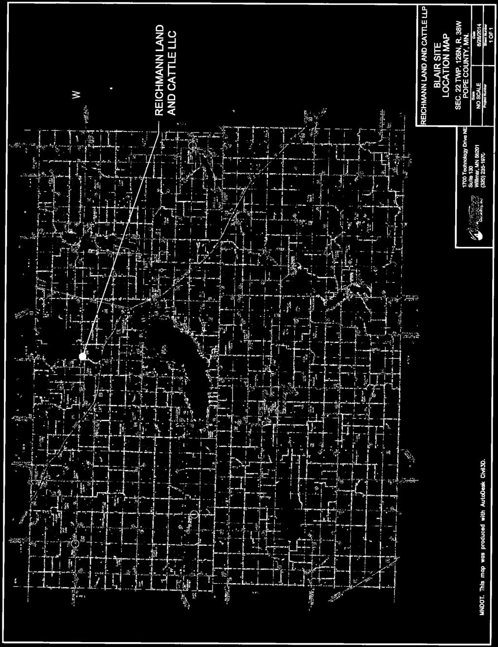

28 ATTACHMENT A

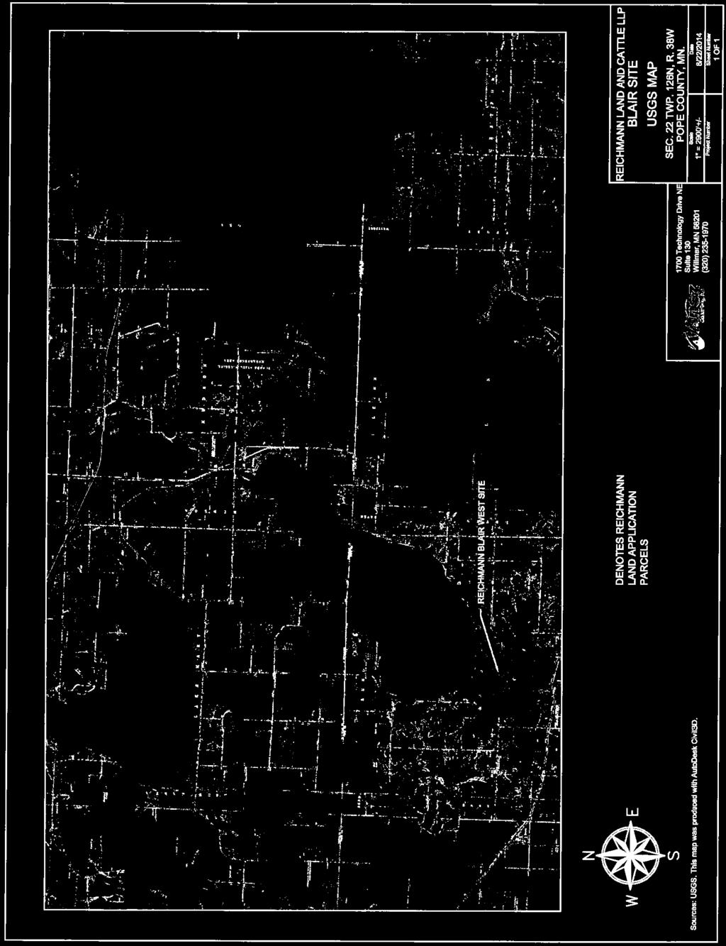
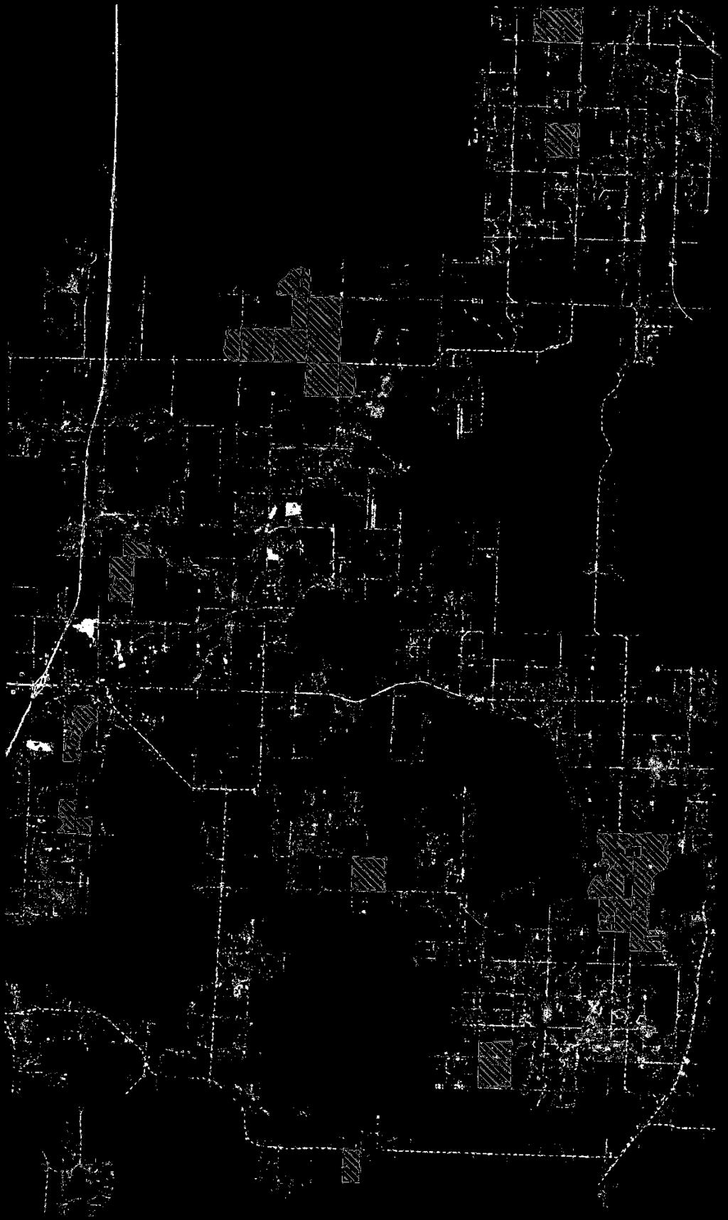


29 ATTACHMENT B
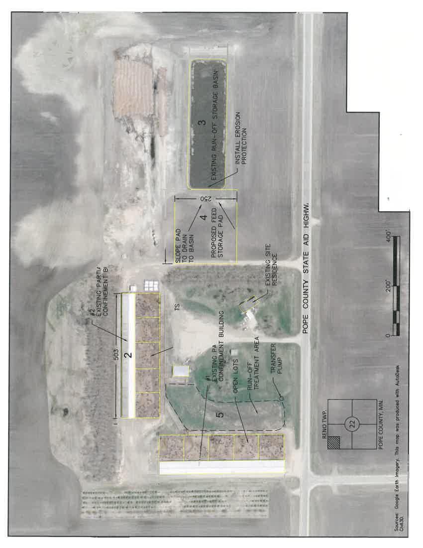


30 ATTACHMENT C
31 ATTACHMENT D
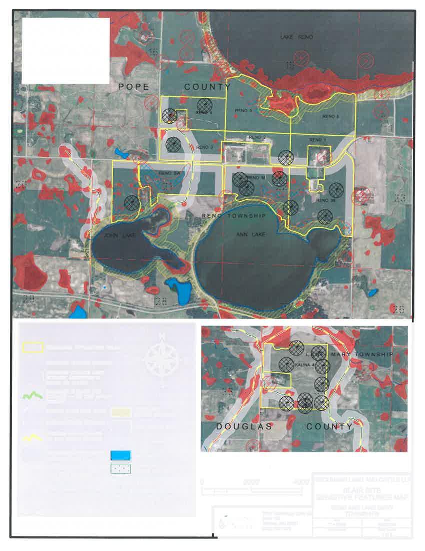
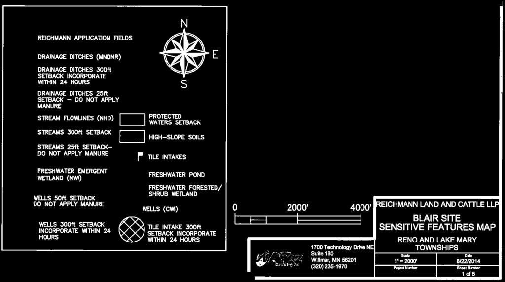
32
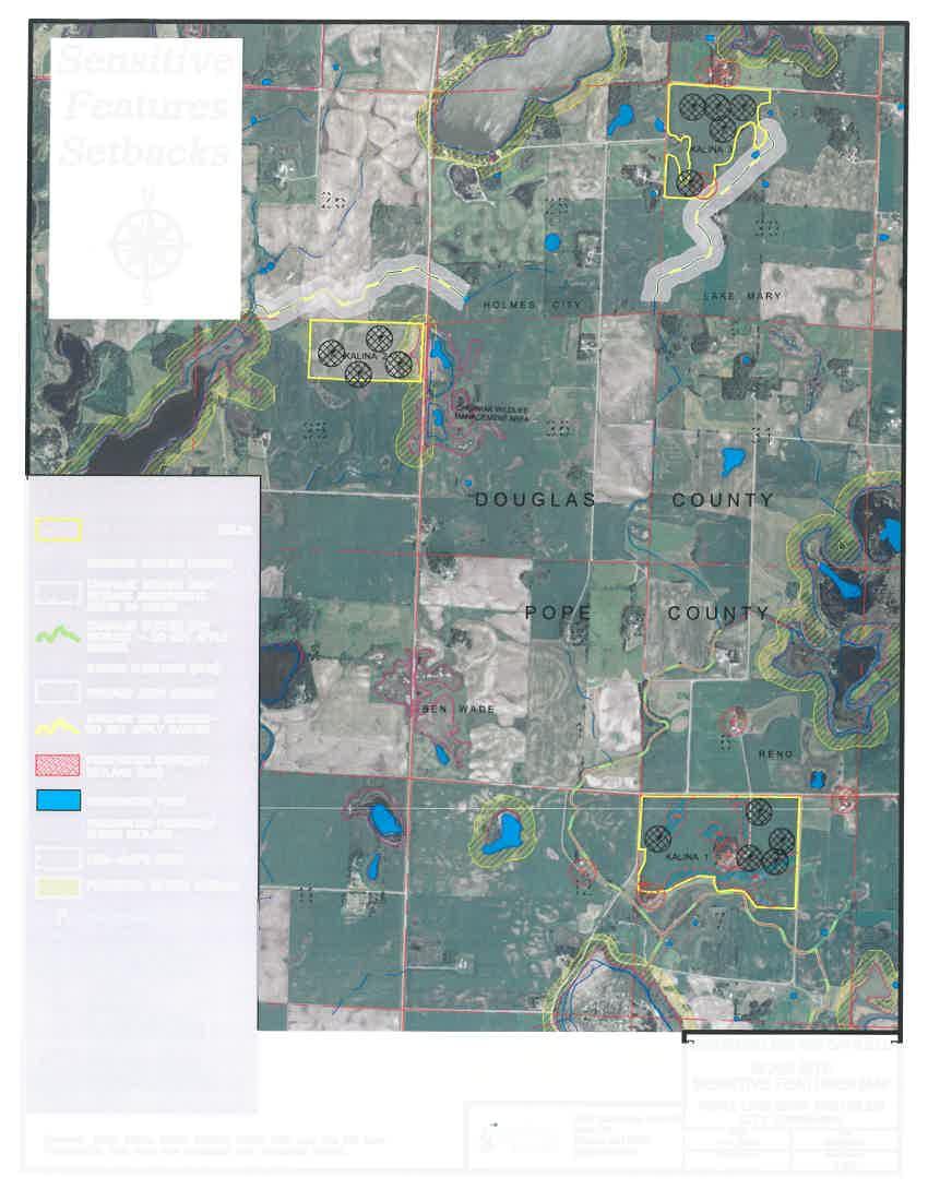
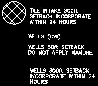
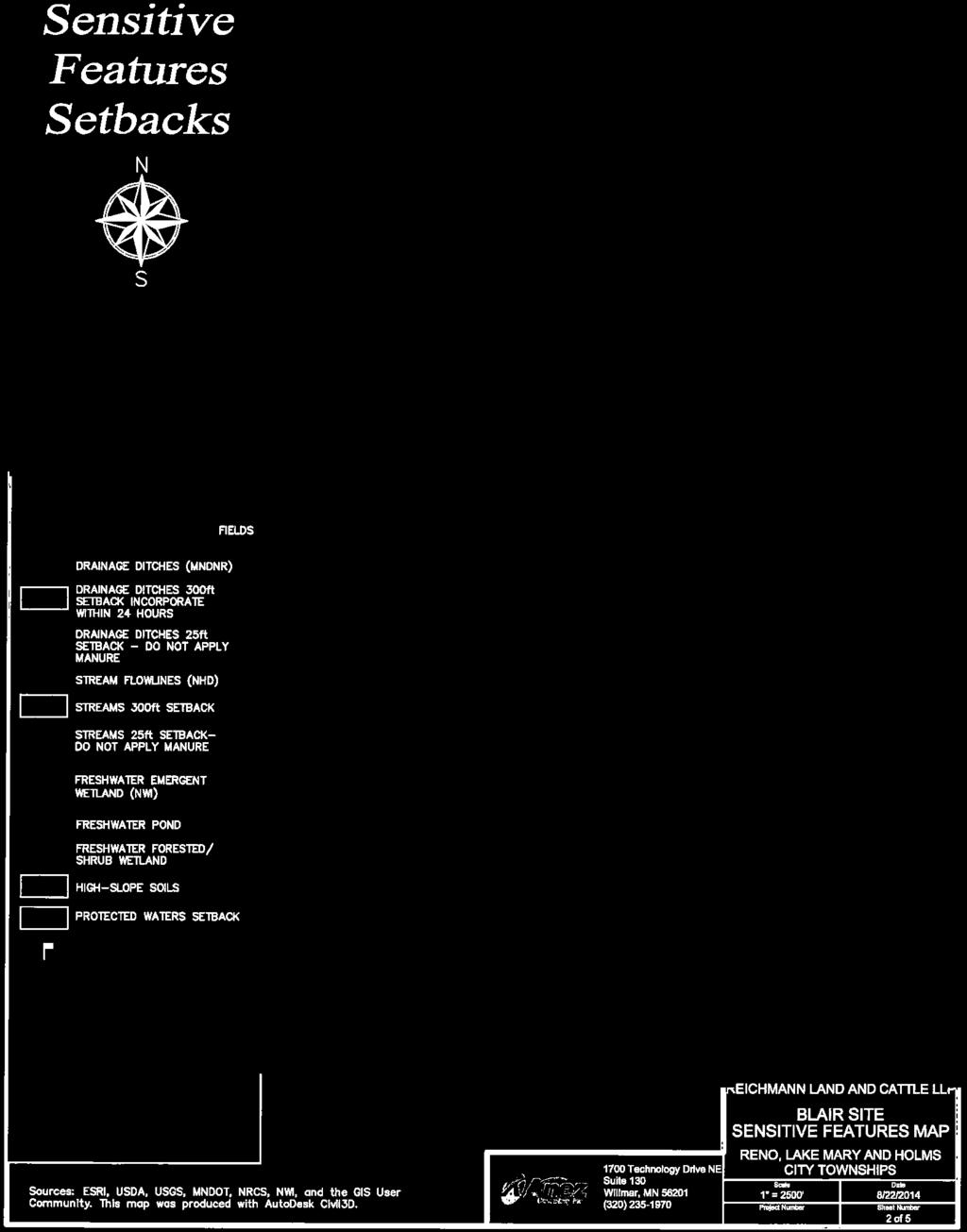
33
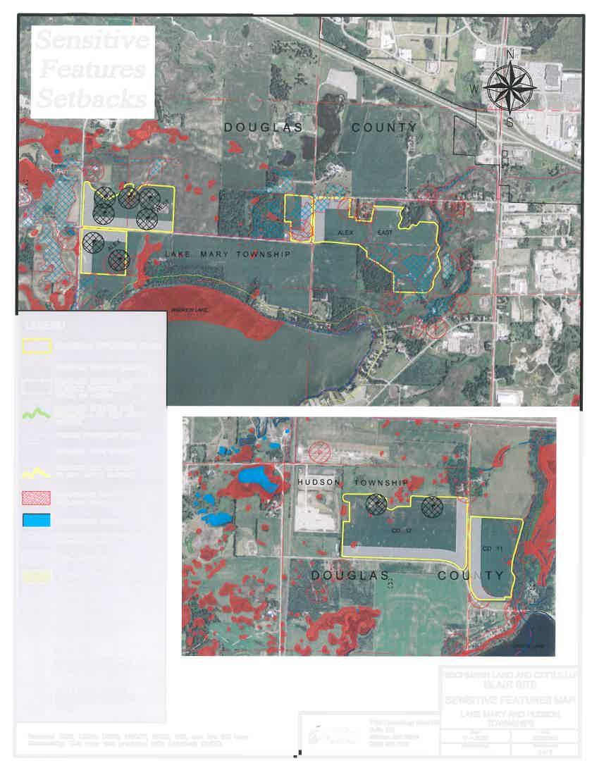

34
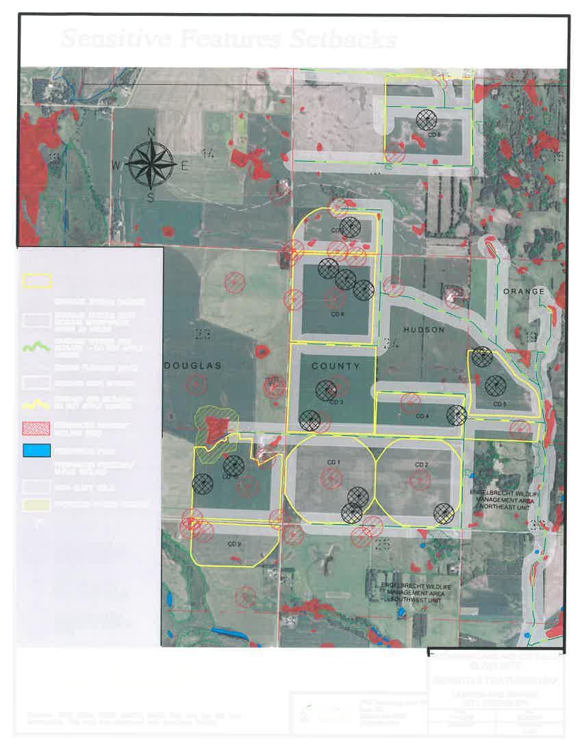
35
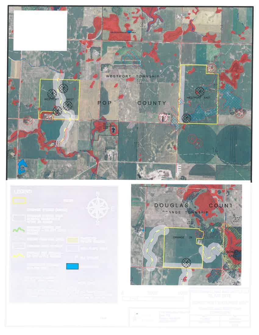
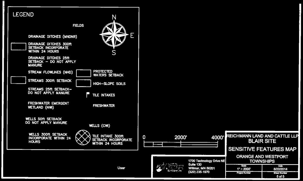
36
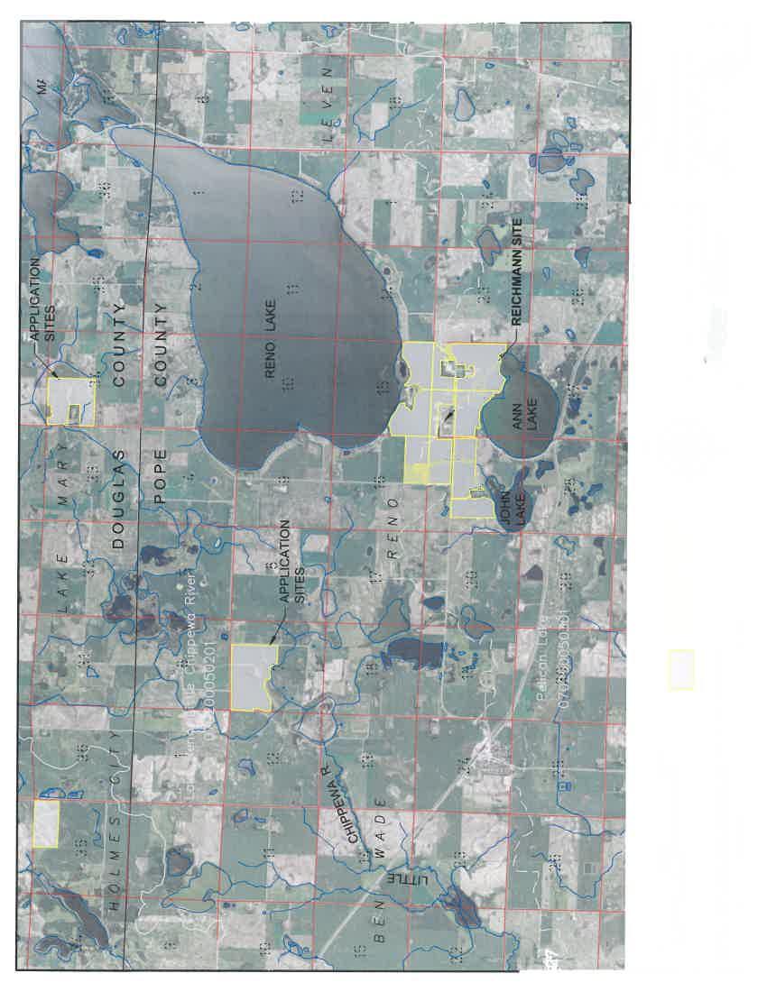
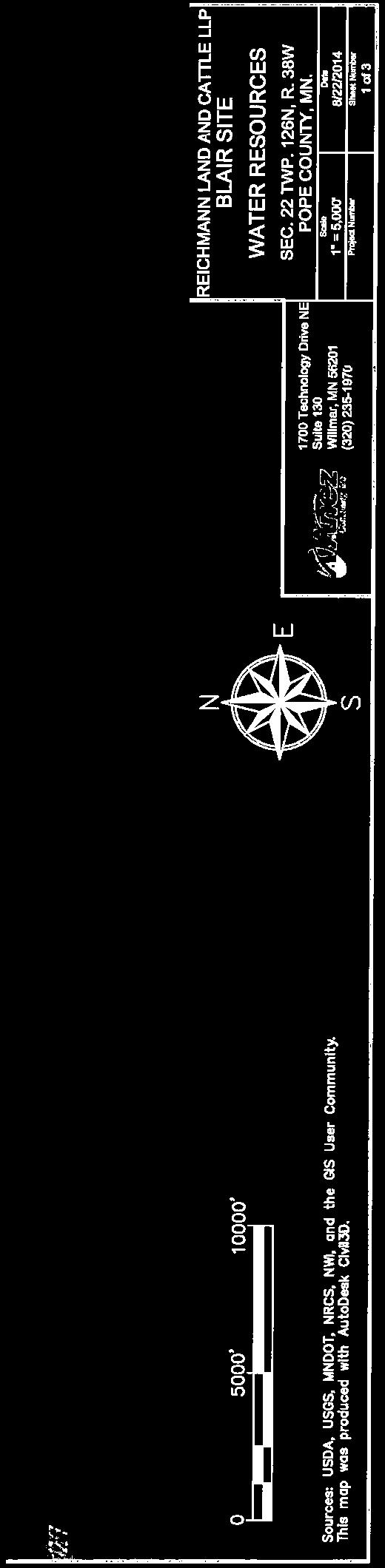

37 ATTACHMENT E
38
39


40 ATTACHMENT F
41
42
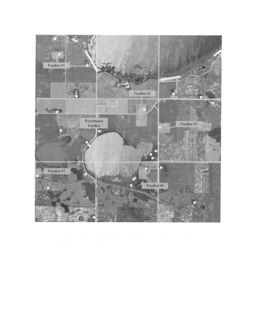
43
44
45
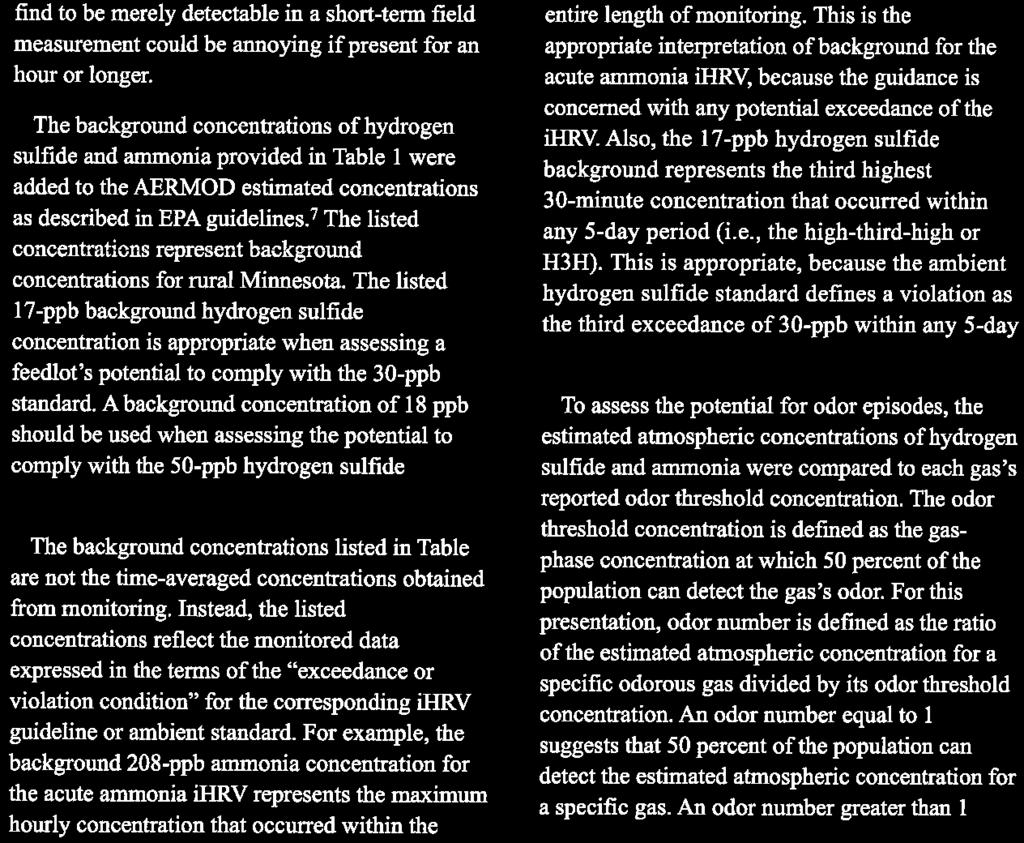
46
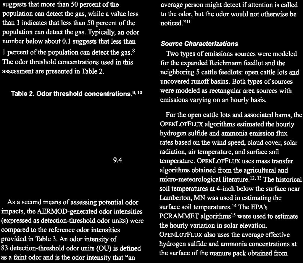
47


48
49
50
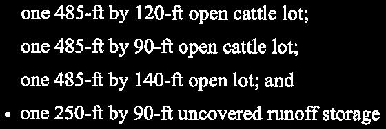
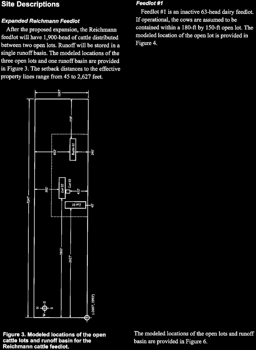
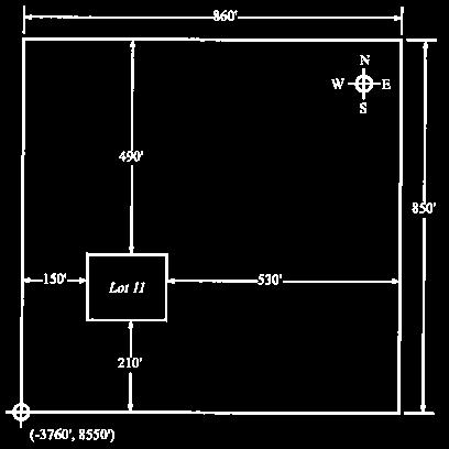
51
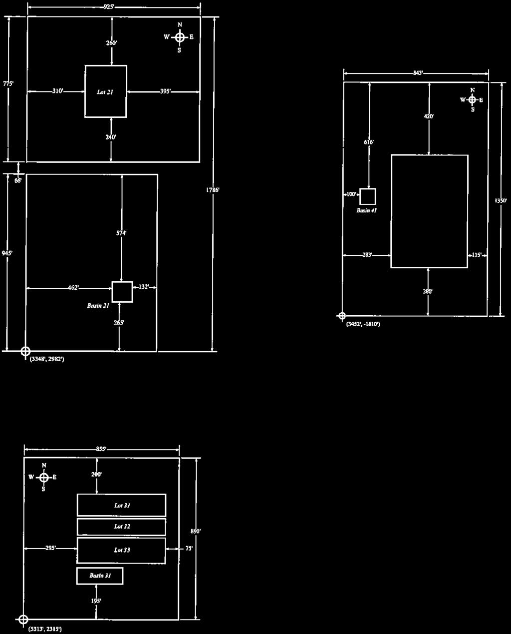
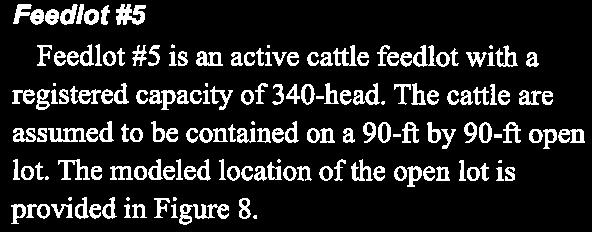
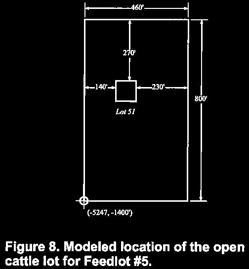
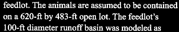
52

53
54
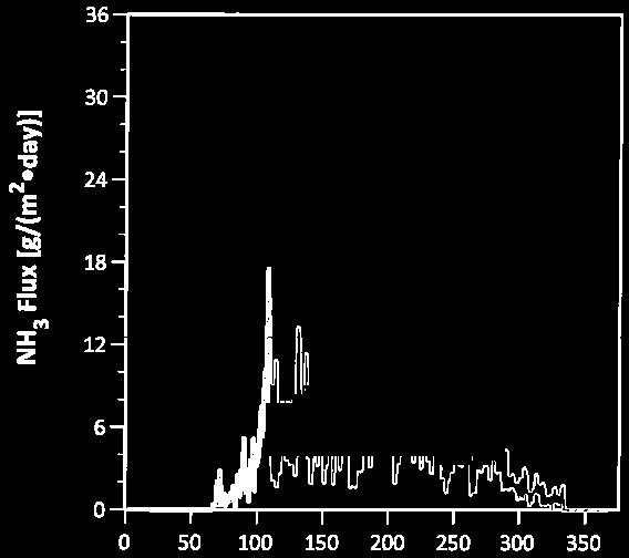
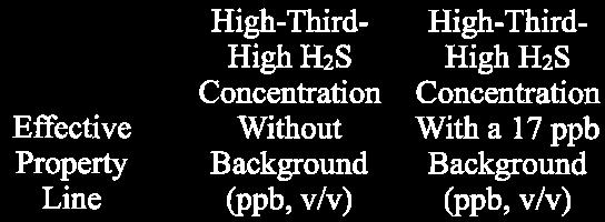
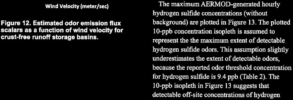
55
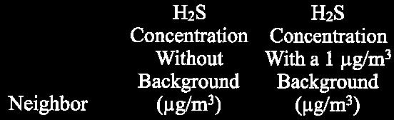

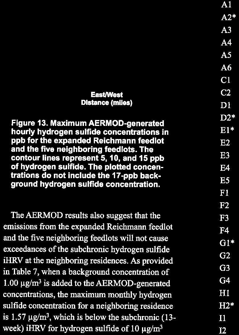
56
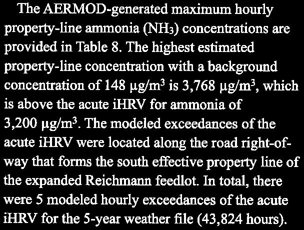
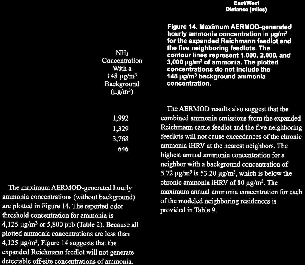
57
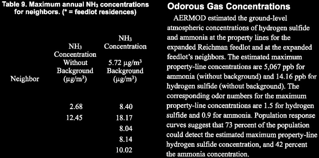
58
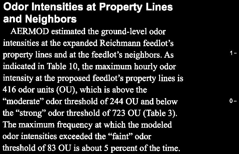
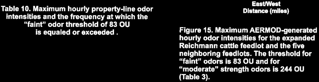
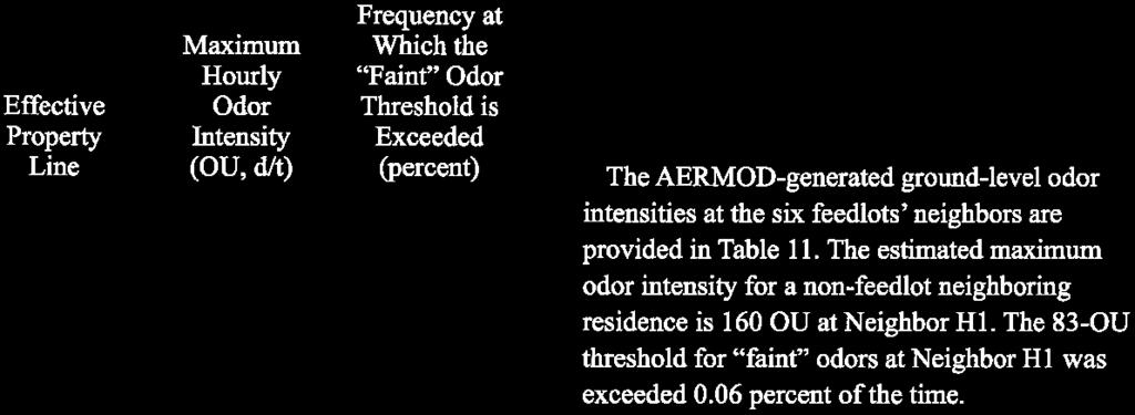
59
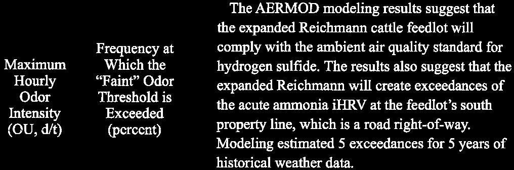
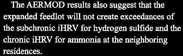
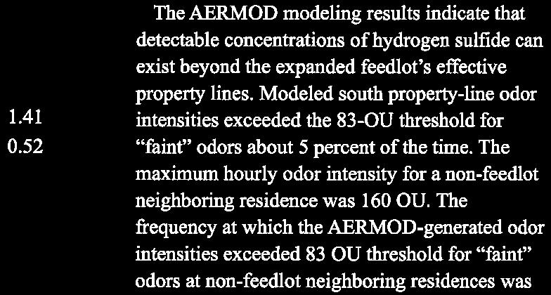
60


61 ATTACHMENT G

62
63
64 ATTACHMENT H

65
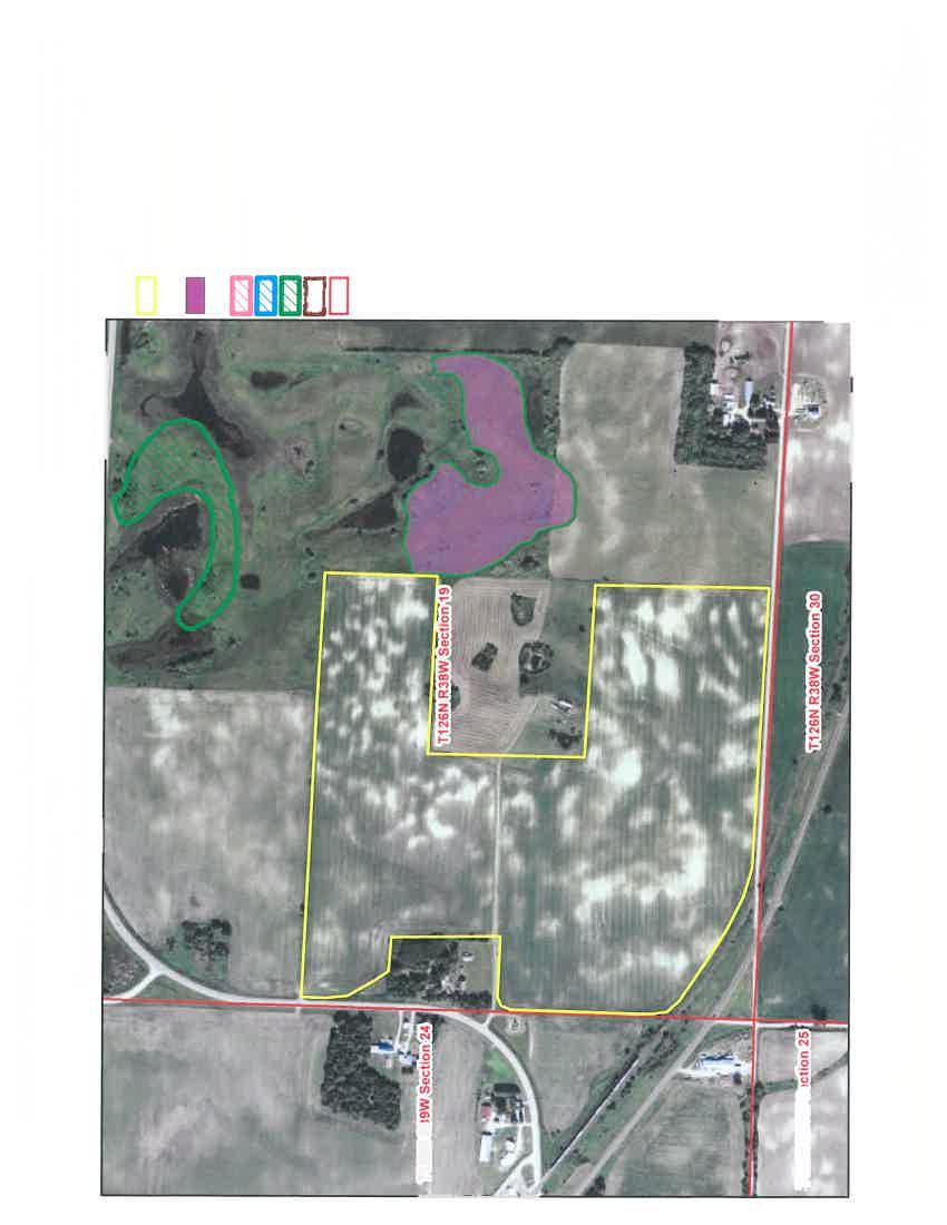


66

67 ATTACHMENT I MINNESOTA DEPARTMENT OF NATURAL RESOURCES FERGUS FALLS OFFICE August 3, 2015 Ted Reichmann Reichmann Land & Cattle, LLP th St Villard, MN Re: Appropriation Permit Blair West Reno Township Section 22, Pope County Dear Mr. Reichmann, DNR was asked by the Minnesota Pollution Control Agency to review the existing well in a similar way that we assess a proposed well. The information is necessary as part of the Environmental Assessment Worksheet (EAW). We have reviewed the well location and have determined that there is a slight risk to some resources. State law¹ requires that wells do not cause harm to ecosystems, degrade water quality, or significantly reduce the public water supply. The site is located between Lake Reno and Lake Ann in the north part of Pope County less than ½ mile from each lake. There are also farmed wetlands shown on the NWI map. Public lands are south of Lake Ann (> 1 mile south of the site) and west approximately 1.85 miles. The well is 175 feet deep in a buried aquifer, so there is only slight chance of impact to surface waters. Although there are other wells in the area that are at a similar depth, the rate and volume of water for this use should not cause harm. The site is greater than 4 miles NW of the City of Glenwood s wellhead protection and water supply source and the Bonanza Valley Groundwater Management Area. There are no trout streams or calcareous fens within 10 miles. The attached map and assessment checklist contains further information about our analysis. If you have questions, please contact me at janell.miersch@state.mn.us or (218) extension 253. Sincerely, Janell Miersch Groundwater Appropriation Hydrologist Enclosure Ec: Charles Peterson, MPCA Al Larsen, Anez Consulting, Inc., agent Tom Hovey, DNR Water Regulations Supervisor Barry Stratton, Southern District Manager PRINTED ON RECYCLED PAPER CONTAINING A mndnr.gov ST AVENUE N FERGUS FALLS, MN MINIMUM OF 10% POST CONSUMER WASTE AN EQUAL OPPORTUNITY EMPLOYER
68 Well Use Assessment, NW¼ Sec 22, T126N, R38W MPARS Tracking Number ERDB This Assessment is not a Water Appropriation Permit. DNR has assessed the proposal for groundwater use livestock watering. The assessment looked at the potential to impact aquifers, groundwater dependent resources and other groundwater users in the area. If a box below is checked, the proposed use has the potential to impact those resources or users. Calcareous fens Designated trout streams Minnesota Biological Survey Sites of Biodiversity Significance (High, Outstanding) Known well interference problems Existing water appropriation permits with higher priority as defined in Statute 103G.261 Publicly owned lands such as DNR Wildlife Management Areas Public Waters lakes, rivers and wetlands Undocumented Domestic Wells Municipal Wellhead Protection Areas, Drinking Water Supply Management Areas, Source Water Protection Areas Known areas of groundwater contamination Groundwater Management Areas and Groundwater Areas of Concern If you have any questions, please contact me at the telephone number or address listed below. Janell Miersch Groundwater Hydrologist Date x253 Janell.Miersch@state.mn.us
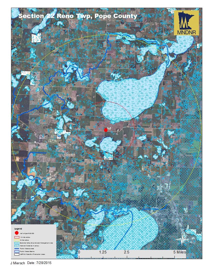
69
Environmental Information Worksheet
 Environmental Information Worksheet Water System Owner (Attach additional sheets if necessary) Needs and Alternatives Provide a brief narrative that describes: Current drinking water system needs. Project
STATE OF MINNESOTA MINNESOTA POLLUTION CONTROL AGENCY FINDINGS OF FACT
 p-ear2-59b STATE OF MINNESOTA MINNESOTA POLLUTION CONTROL AGENCY IN THE MATTER OF THE DECISION ON THE NEED FOR AN ENVIRONMENTAL IMPACT STATEMENT FOR THE PROPOSED HEARTLAND HUTTERIAN BRETHREN, INC. FEEDLOT
Feedlot Construction Setbacks from Open Water and Wells
 Feedlot Construction Setbacks from Open Water and Wells Water Quality/Feedlots #8.30 May 2009 Contents New and expanded feedlots near waters... 2 Setbacks from wells... 3 Public water supply wells... 4
Alternative EAW Form for Animal Feedlots ENVIRONMENTAL ASSESSMENT WORKSHEET
 Alternative EAW Form for Animal Feedlots ENVIRONMENTAL ASSESSMENT WORKSHEET Note to reviewers: The Worksheet (EAW) provides information about a project that may have the potential for significant environmental
STATE OF MINNESOTA MINNESOTA POLLUTION CONTROL AGENCY FINDINGS OF FACT FACILITY HISTORY
 STATE OF MINNESOTA MINNESOTA POLLUTION CONTROL AGENCY IN THE MATTER OF THE DECISION ON THE NEED FOR AN ENVIRONMENTAL IMPACT STATEMENT FOR THE PROPOSED NEW SWEDEN DAIRY NEW SWEDEN TOWNSHIP NICOLLET COUNTY,
STATE OF MINNESOTA MINNESOTA POLLUTION CONTROL AGENCY
 STATE OF MINNESOTA MINNESOTA POLLUTION CONTROL AGENCY In the Matter of the Decision on the Need for an Environmental Impact Statement for the Proposed Remer Wastewater Treatment Facility Expansion FINDINGS
Manure Management Manual Revisions
 Manure Management Manual Revisions Jim Spontak PA DEP Farms In PA 63,136 farms in PA 33813 have livestock Average farm is 124 acres, about 75% under 200 acres Women as the primary farm operator increased
MINNESOTA ENVIRONMENTAL QUALITY BOARD
 Next Publication: August 20, 2012 Vol. 36, No. 16 Submittal Deadline: August 13, 2012 Submit to EQB.Monitor@state.mn.us Subscribe to receive the EQB Monitor. If you would like to receive the Monitor regularly,
Notice of Availability of an Environmental Assessment Worksheet (EAW) Campbell Dairy
 Campbell Dairy") Notice of Availability of an Environmental Assessment Worksheet (EAW) Campbell Dairy Doc Type: Public Notice Public Comment Information EAW Public comment period begins: December 19, 2016 EAW Public comment
Notice of Availability of an Environmental Assessment Worksheet (EAW) Campbell Dairy Doc Type: Public Notice Public Comment Information EAW Public comment period begins: December 19, 2016 EAW Public comment
STATE OF MINNESOTA MINNESOTA POLLUTION CONTROL AGENCY FINDINGS OF FACT
 p-ear2-44b STATE OF MINNESOTA MINNESOTA POLLUTION CONTROL AGENCY IN THE MATTER OF THE DECISION ON THE NEED FOR AN ENVIRONMENTAL IMPACT STATEMENT FOR THE PROPOSED RANDY S SANITATION TRANSFER FACILITY PROPOSED
Alternative EAW Form for Animal Feedlots ENVIRONMENTAL ASSESSMENT WORKSHEET
 Alternative EAW Form for Animal Feedlots ENVIRONMENTAL ASSESSMENT WORKSHEET Note to reviewers: The Environmental Assessment Worksheet (EAW) provides information about a project that may have the potential
STATE OF MINNESOTA MINNESOTA POLLUTION CONTROL AGENCY FINDINGS OF FACT
 STATE OF MINNESOTA MINNESOTA POLLUTION CONTROL AGENCY IN THE MATTER OF THE DECISION ON THE NEED FOR AN ENVIRONMENTAL IMPACT STATEMENT FOR THE PROPOSED LESTER PRAIRIE WASTEWATER TREATMENT FACILITY EXPANSION
TORCH LAKE TOWNSHIP WATER QUALITY ACTION PLAN
 TORCH LAKE TOWNSHIP WATER QUALITY ACTION PLAN Elk-River-Chain-of-Lakes Gaps Analysis Project The Watershed Center Grand Traverse Bay Tip of the Mitt Watershed Council Michigan Department of Natural Resources
Minnesota Pollution Control Agency
 STATE OF MINNESOTA Watershed Division National Pollutant Discharge Elimination System (NPDES)/ State Disposal System (SDS) Permit for a Concentrated Animal Feeding Operation (CAFO) Permit Number MN0070548
STATE OF MINNESOTA MINNESOTA POLLUTION CONTROL AGENCY FINDINGS OF FACT. Project Description
 STATE OF MINNESOTA MINNESOTA POLLUTION CONTROL AGENCY IN THE MATTER OF THE DECISION ON THE NEED FOR AN ENVIRONMENTAL IMPACT STATEMENT FOR THE PROPOSED STEMMER RIDGE ROAD TRUNK SANITARY SEWER EXTENSION
Agricultural/Rural Riparian Buffer Analysis
 Agricultural/Rural Riparian Buffer Analysis December 2014 Executive Summary The Agricultural/Rural Riparian Buffer Analysis was developed from a 2014 analysis of current requirements for the riparian areas
Minnesota Pollution Control Agency
 STATE OF MINNESOTA Watershed Division National Pollutant Discharge Elimination System (NPDES)/ State Disposal System (SDS) Permit for a Concentrated Animal Feeding Operation (CAFO) Permit Number MN0070394
COMPREHENSIVE NUTRIENT MANAGEMENT PLAN REVIEW CHECKLIST FOR CERTIFIED CNMP PROVIDERS
 Customer Name: CNMP Preparer s Name: CNMP Reviewer s Name and Date: COMPREHENSIVE NUTRIENT MANAGEMENT PLAN REVIEW CHECKLIST FOR CERTIFIED CNMP PROVIDERS COMPONENT Yes No NA 1. Overview - Brief statement
Completing an NPDES or SDS Feedlot Permit Application
 www.pca.state.mn.us Completing an NPDES or SDS Feedlot Permit Application These instructions will assist you in preparing a permit application for an animal feedlot or manure storage area which requires
IOWA LIVESTOCK ENVIRONMENTAL REGULATIONS & MANURE AGREEMENTS
 IOWA LIVESTOCK ENVIRONMENTAL REGULATIONS & MANURE AGREEMENTS IOWA PORK PRODUCERS ASSOCIATION January 23, 2008 Eldon McAfee ANIMAL CAPACITY Animal weight capacity and animal unit capacity Constructed before
VIRGINIA POLLUTION ABATEMENT (VPA) PERMIT APPLICATION. FORM B - ANIMAL FEEDING OPERATIONS (AFOs)
 PERMIT APPLICATION. FORM B - ANIMAL FEEDING OPERATIONS (AFOs)") VIRGINIA POLLUTION ABATEMENT (VPA) PERMIT APPLICATION FORM B - ANIMAL FEEDING OPERATIONS (AFOs) Department of Environmental Quality Rev. 02-2013 VIRGINIA POLLUTION ABATEMENT (VPA) PERMIT APPLICATION FORM
VIRGINIA POLLUTION ABATEMENT (VPA) PERMIT APPLICATION FORM B - ANIMAL FEEDING OPERATIONS (AFOs) Department of Environmental Quality Rev. 02-2013 VIRGINIA POLLUTION ABATEMENT (VPA) PERMIT APPLICATION FORM
Hello my name is Joy Loughry and I am with the groundwater technical unit of the Minnesota department of natural resources. Today I am going to talk
 Hello my name is Joy Loughry and I am with the groundwater technical unit of the Minnesota department of natural resources. Today I am going to talk about how the state of Minnesota manages its Water resources
Nutrient Management in. A presentation to the West Metro Water Alliance
 Nutrient Management in Developing and Agricultural Areas A presentation to the West Metro Water Alliance Chris Meehan, P.E. May 25, 2011 Agenda Physical Improvements Planning Improvements How to get it
WATERSHED. Maitland Valley. Report Card 201
 Maitland Valley WATERSHED Report Card 201 The Maitland Valley Conservation Authority has prepared this report card as a summary on the state of our forests, wetlands, surface water, and ground water resources.
COON CREEK WATERSHED DISTRICT PERMIT REVIEW. Spring Lake Park Schools Westwood Middle School st Avenue NE, Spring Lake Park, MN 55432
 PAN 16-112, Westwood Middle School, Page 1 of 6 COON CREEK WATERSHED DISTRICT PERMIT REVIEW MEETING DATE: August 22, 2016 AGENDA NUMBER: 10 FILE NUMBER: 16-112 ITEM: Westwood Middle School RECOMMENDATION:
VILLAGE OF BELLAIRE WATER QUALITY ACTION PLAN
 VILLAGE OF BELLAIRE WATER QUALITY ACTION PLAN Elk-River-Chain-of-Lakes Gaps Analysis Project The Watershed Center Grand Traverse Bay Tip of the Mitt Watershed Council Michigan Department of Natural Resources
MINNESOTA POLLUTION CONTROL AGENCY. Resource Management and Assistance Division. Board Item Cover Sheet
 p-ear2-43c MINNESOTA POLLUTION CONTROL AGENCY Resource Management and Assistance Division Board Item Cover Sheet MEETING DATE: August 27, 2012 DATE MAILED: August 17, 2012 Presenter(s): Karen Kromar Phone
CHAPTER 6 ADDITIONAL STANDARDS APPLYING TO SHORELAND AREAS AND PUBLIC WATERS
 CHAPTER 6 ADDITIONAL STANDARDS APPLYING TO SHORELAND AREAS AND PUBLIC WATERS Section 1 Intent. 49 Section 2 Floodplain Requirements 49 Section 3 Water-Oriented Accessory Structures 50 Section 4 Stairways,
State Regulations Fact Sheet - Wisconsin
 State Regulations Fact Sheet - Wisconsin Spill Response What is a spill? : A spill is any release that has the potential to threaten ground or surface water. 1. A spill is site specific, 3,000 gallons
Alternative EAW Form for Animal Feedlots ENVIRONMENTAL ASSESSMENT WORKSHEET
 Alternative EAW Form for Animal Feedlots ENVIRONMENTAL ASSESSMENT WORKSHEET Note to reviewers: The Environmental Assessment Worksheet (EAW) provides information about a project that may have the potential
Municipal Stormwater Management Planning
 Municipal Stormwater Management Planning Christopher C. Obropta, Ph.D., P.E. Water Resources Extension Specialist with Rutgers Cooperative Extension Assistant Professor with Department of Environmental
Missouri Concentrated Animal Feeding Operation Nutrient Management Technical Standard
 Missouri Concentrated Animal Feeding Operation Nutrient Management Technical Standard March 4, 2009 Division of Environmental Quality Water Protection Program I Introduction A. Authority and Purpose Missouri
NUTRIENT MANAGEMENT (ac.) CODE 590
 CODE 590") IG-590-1 NATURAL RESOURCES CONSERVATION SERVICE CONSERVATION PRACTICE INSTALLATION GUIDELINES NUTRIENT MANAGEMENT (ac.) CODE 590 GUIDELINES APPLICABLE FOR ALL PURPOSES Nutrient management activities shall
IG-590-1 NATURAL RESOURCES CONSERVATION SERVICE CONSERVATION PRACTICE INSTALLATION GUIDELINES NUTRIENT MANAGEMENT (ac.) CODE 590 GUIDELINES APPLICABLE FOR ALL PURPOSES Nutrient management activities shall
BIG ROCHE A CRI LAKE CHARACTERISTICS
 BIG ROCHE A CRI LAKE CHARACTERISTICS Lake Description Big Roche Cri Lake is located in north central Adams County and has a surface area of 205 acres, a shoreline length of 6.1 mile, a volume of 6,993
C Fish Lake C Rice Lake C Mud Lake C Weaver Lake C Elm Creek*
 IV. PROBLEMS AND CORRECTIVE ACTIONS Outlined below is an assessment of existing and potential water resource-related issues that are known at this time. These issues have been identified based on Commission
VIRGINIA POLLUTION ABATEMENT PERMIT APPLICATION
 VIRGINIA POLLUTION ABATEMENT PERMIT APPLICATION FORM B ANIMAL WASTE Department of Environmental Quality VPA FORM B ANIMAL WASTE INSTRUCTIONS This form is to be completed by applicants requesting a VPA
Characteristics of Land Resources
 Chapter Chapter 1 Characteristics of Land Resources The geology, soils and topography of Woodford County T he geology, soils and topography of an area are important to the community planning process for
STATE OF MINNESOTA MINNESOTA POLLUTION CONTROL AGENCY FINDINGS OF FACT
 STATE OF MINNESOTA MINNESOTA POLLUTION CONTROL AGENCY IN THE MATTER OF THE DECISION ON THE NEED FOR AN ENVIRONMENTAL IMPACT STATEMENT FOR THE PROPOSED ROYALTON WASTEWATER TREATMENT FACILITY EXPANSION ROYALTON
LPES Small Farms Fact Sheets* Got Barnyard Runoff? By Chris Henry, University of Nebraska-Lincoln, and Joe Harner, Kansas State University
 LPES Small Farms Fact Sheets* By Chris Henry, University of Nebraska-Lincoln, and Joe Harner, Kansas State University Summary Uncontrolled runoff from barnyards and open lots can contain nutrients and
Manure Storage for Environmental Management Systems
 WiMStor01 MStor Manure Storage for Environmental Management Systems Key: 1)Low Risk 2)Low-Moderate Risk 3)Moderate-High Risk 4)High Risk Location of Manure Storage Are the manure storage facilities in
Red Rock Lake: A Path Forward
 University of Minnesota Morris Digital Well University of Minnesota Morris Digital Well Center for Small Towns 6-2016 Red Rock Lake: A Path Forward Colette Millard Student - University of Minnesota, Morris
Blue Earth County Code
 Blue Earth County Code Sec. 114-116 Special Provisions (b) Agriculture use standards. (1)General cultivation farming, grazing, nurseries, horticulture, truck farming, sod farming and wild crop harvesting
Application for General Stormwater Permit for Construction Activity (MN R100001)
") Complete your application online! Application for General Stormwater Permit for Construction Activity (MN R100001) National Pollutant Discharge Elimination System / State Disposal System (NPDES/SDS) Please
Complete your application online! Application for General Stormwater Permit for Construction Activity (MN R100001) National Pollutant Discharge Elimination System / State Disposal System (NPDES/SDS) Please
A. Section One Definitions of Feedlot Ordinance Page
 SECTION 22 FEEDLOT ORDINANCE A. Section One Definitions of Feedlot Ordinance Page 99-102 B. Section Two New Feedlots 1. New Feedlot Permit Requirements Page 103 2. New Feedlot Permit Issuance Page 104
Land Application of Manure
 University of Nebraska Cooperative Extension EC 98-758-S WORKSHEET 11 Nebraska s Farm Assessment System for Assessing the Risk of Water Contamination Why should I be concerned? Stewardship of soil and
ENVIRONMENTAL ASSESSMENT WORKSHEET
 ENVIRONMENTAL ASSESSMENT WORKSHEET Note to reviewers: The Environmental Assessment Worksheet (EAW) provides information about a project that may have the potential for significant environmental effects.
STATE OF MINNESOTA MINNESOTA POLLUTION CONTROL AGENCY
 p-ear2-80b STATE OF MINNESOTA MINNESOTA POLLUTION CONTROL AGENCY IN THE MATTER OF THE DECISION ON THE NEED FOR AN ENVIRONMENTAL IMPACT STATEMENT FOR THE PROPOSED REG ALBERT LEA, LLC PROJECT FREEBORN COUNTY
DAKOTA COUNTY SOIL AND WATER CONSERVATION DISTRICT COMPREHENSIVE PLAN
 DAKOTA COUNTY SOIL AND WATER CONSERVATION DISTRICT COMPREHENSIVE PLAN 2011-2015 4100 220 th Street West, Suite 102 Farmington, MN 55024 651-480-7777 www.dakotacountyswcd.org I. INTRODUCTION A. Purpose
This page intentionally left blank
 Monterey County has elected to include an as part of the General Plan. Agriculture consisting of crop farming and livestock grazing is the largest industry in the County and contributes a significant amount
1. GENERAL DESCRIPTION OF LAND USE / COVER TYPES (SEE GENERAL DESCRIPTIONS ON PAGE 7) A 2. ADJACENT LANDS & EASEMENTS 3. FAMILY AGRICULTURAL LEGACY
 A 2. ADJACENT LANDS & EASEMENTS 3. FAMILY AGRICULTURAL LEGACY") CONSERVATION EASEMENT PROJECT: COUNTY: NAME OF LANDOWNER: CELL/OFFICE PHONE: NAME OF FARM / SITE MANAGER: CELL/OFFICE PHONE: GENERAL DESCRIPTION OF LAND USE / COVER TYPES (SEE GENERAL DESCRIPTIONS ON PAGE
CONSERVATION EASEMENT PROJECT: COUNTY: NAME OF LANDOWNER: CELL/OFFICE PHONE: NAME OF FARM / SITE MANAGER: CELL/OFFICE PHONE: GENERAL DESCRIPTION OF LAND USE / COVER TYPES (SEE GENERAL DESCRIPTIONS ON PAGE
Comfort Lake-Forest Lake Watershed District Six Lakes Total Maximum Daily Load Implementation Plan
 Prepared by: for the Comfort Lake-Forest Lake Watershed District and the Minnesota Pollution Control Agency Comfort Lake-Forest Lake Watershed District Six Lakes Total Maximum Daily Load February 16, 2010
Chapter 10 Natural Environment
 Chapter 10 Natural Environment Existing Conditions The Natural Environment Element addresses the protection, conservation, preservation, and restoration of the natural resources the Bayview Ridge Subarea,
LPES Small Farms Fact Sheets* Small-Scale Farmers and the Environment: How to be a Good Steward. By Mark Rice, North Carolina State University
 LPES Small Farms Fact Sheets* Small-Scale Farmers and the Environment: How to be a Good Steward By Mark Rice, North Carolina State University Summary Good stewardship is important for everyone, including
Small-Scale Farmers and the Environment: How to be a Good Steward
 L P E S Small Farms Fact Sheet series Livestock and Poultry Environmental Stewardship < L P E S > Curriculum : How to be a Good Steward By Mark Rice, North Carolina State University Summary Good stewardship
Chapter 516 Shoreland Districts
 Chapter 516 Shoreland Districts 516.01 Statutory Authorization The State of Minnesota in Minnesota Statutes, Chapter 103F, has defined shoreland areas and described limitations on uses and locations of
ENVIRONMENTAL ASSESSMENT WORKSHEET
 ENVIRONMENTAL ASSESSMENT WORKSHEET Note to reviewers: The Environmental Assessment Worksheet (EAW) provides information about a project that may have the potential for significant environmental effects.
County: City: State: Zip: Phone#: Person Permit Issued To: Farm Physical Address: Phone#:
 PROGRAM YEAR 2011 GEORGIA DEPARTMENT OF AGRICULTURE LIVESTOCK/POULTRY FIELD FORCES AFO/CAFO INSPECTIONS NPDES D S CL GENERAL INFORMATION: Inspector's Name: Inspector's Number: GDA Est #: Landowner's Name:
Environmental Consideration of Dairy Systems
 Environmental Consideration of Dairy Systems Phosphorus and Water Quality Neil Hansen, Colorado State University neil.hansen@colostate.edu Environmental Issues Agricultural nutrients in surface and ground
Maintaining and Improving the Health of All Minnesotans
 Protecting, Maintaining and Improving the Health of All Minnesotans 7/10/17 Stephanie Adams 12 Hwy 28 E St 2 Morris, MN 56267 Dear Stephanie: Subject: Initial Comment Letter, One Watershed One Plan Thank
Nutrient BMP Evaluation Project: Preliminary Conclusions
 Nutrient BMP Evaluation Project: Preliminary Conclusions Manure Management Update 2013 Conference Lethbridge, AB January 14, 2013 Beneficial Management Practices How effective are they, what are the costs,
Sustainable Natural Environment Fish Habitat
 Town of Huntsville Official Plan Review - POLICY BACKGROUND PAPER Sustainable Natural Environment Fish Habitat BACKGROUND: Lakes, rivers, streams, ponds and many wetlands provide fish habitat. Intermittent
Nitrate, Well Testing and Rules
 Nitrate, Well Testing and Rules Where is all this heading? February 7, 2017 Pesticide and Fertilizer Management Division Minnesota Department of Agriculture Outline Nitrogen Fertilizer Management Plan
Information for File # PRH
 Information for File # 2016-02602-PRH Applicant Corps Contact Tom Morley Paul Hauser Address 152 Baker Drive, Redwood Falls, MN 56283 E-Mail Paul.R.Hauser@usace.army.mil Phone 651-290-5357 Primary County
Department of the Army Permit Application
 Department of the Army Permit Application DA File Number U.S. Army Corps of Engineers Honolulu District Date Received by CEPOH-RO Send Completed Application to: Honolulu District, U.S. Army Corps of Engineers
Wastewater Treatment & Water Supply Alternatives Analysis
 Wastewater Treatment & Water Supply Alternatives Analysis Lake Sallie & Lake Melissa Chain of Lakes Prepared for Pelican River Watershed District February 2008 Table of Contents 1.0 EXECUTIVE SUMMARY...
Minnesota Pollution Control Agency
 Minnesota Pollution Control Agency STATE OF MINNESOTA Minnesota Pollution Control Agency MUNICIPAL DIVISION PUBLIC NOTICE OF INTENT TO REISSUE NATIONAL POLLUTANT DISCHARGE ELIMINATION SYSTEM (NPDES)/ STATE
WELCOME TO THE CONSTRUCTION STORMWATER PERMIT WEBINAR
 WELCOME TO THE CONSTRUCTION STORMWATER PERMIT WEBINAR All the documents shown today are in the MN Stormwater Manual on the page titled 2018 Construction Stormwater Permit Public Notice and Public Informational
Water Plans. Water Plans: Houston County LWMP amended 2012 Winona County LWMP
 Mississippi River La Crescent Watershed: Water Plans The Mississippi River La Crescent Watershed encompasses Houston and Winona Counties. Each county has developed a 10-year rotating comprehensive local
State of Florida Department of Community Affairs Areas of Critical State Concern Implementation Status Report Apalachicola Bay Area
 State of Florida Department of Community Affairs Areas of Critical State Concern Implementation Status Report Apalachicola Bay Area Thaddeus L. Cohen, AIA Secretary November 2006 CONTENTS Part 1 - Summary
THE FUTURE OF NUTRIENT MANAGEMENT IN WISCONSIN
 THE FUTURE OF NUTRIENT MANAGEMENT IN WISCONSIN Susan M. Porter 1 The Department of Agriculture, Trade and Consumer Protection (DATCP) is responsible for promulgating nutrient management rules in Wisconsin
NJDEP Regulations that impact or soon will impact agricultural operations. April 1, 2007 Horses 2007
 NJDEP Regulations that impact or soon will impact agricultural operations. April 1, 2007 Horses 2007 Peter L. Kallin, Ph.D., P.W.S. Phone: 732-499-3600 Ext. 237 E-mail: pkallin@aesop.rutgers.edu www.water.rutgers.edu
SECTION 3 NATURAL RESOURCES
 SECTION 3 NATURAL RESOURCES The natural environment plays a large role in planning for future development. Environmental conditions, such as topography, wetlands, floodplains, and water bodies, can often
05/24/17 REVISOR JRM/SA RD4337
 05/24/17 REVISOR JRM/SA RD4337 1.1 Department of Agriculture 1.2 Proposed Permanent Rules Relating to Water Resource Protection Requirements 1.3 1573.0010 DEFINITIONS. 1.4 Subpart 1. Scope. The terms used
Divorne Farms Ltd SE W
 TECHNICAL REVIEW COMMITTEE A TECHNICAL REVIEW REPORT PREPARED FOR THE RURAL MUNICIPALITY OF G R EY Divorne Farms Ltd SE 08-08-06W Dra November 22, 2013 INTRODUCTION The Technical Review Committee (TRC)
Mud Lake Lakeshed Assessment
 Mud Lake Lakeshed Assessment The lakeshed vitals table identifies where to focus organizational and management efforts for each lake. Criteria were developed using limnological concepts to determine the
Chapter 13: Wildlife and Vegetation
 Chapter 13: Wildlife and Vegetation Introduction and Setting Nevada County contains an extremely wide range of plants, animals and habitat types. With topographic elevations ranging from 300 feet in the
Conservation Practices. Conservation Choices. These five icons will show the benefits each practice offers... 6/4/2014
 Conservation Choices Your guide to conservation and environmental farming practices. Conservation Choices These five icons will show the benefits each practice offers... The practice reduces soil erosion
Ingham County Drain Commissioner Patrick E. Lindemann 707 BUHL AVENUE P. O. BOX 220 MASON MI PH. (517) FAX (517)
 FAX (517)") Date Issued Ingham County Drain Commissioner Patrick E. Lindemann 707 BUHL AVENUE P. O. BOX 220 MASON MI 48854 PH. (517) 676-8395 FAX (517) 676-8364 APPLICATION FOR SOIL EROSION AND SEDIMENTATION POLLUTION
Date Issued Ingham County Drain Commissioner Patrick E. Lindemann 707 BUHL AVENUE P. O. BOX 220 MASON MI 48854 PH. (517) 676-8395 FAX (517) 676-8364 APPLICATION FOR SOIL EROSION AND SEDIMENTATION POLLUTION
ORDINANCE NO. 1. A large concentrated animal feeding operation as described in Table 1 in Section 3.07.
 ORDINANCE NO. AN ORDINANCE OF CLAY COUNTY, SD, AMENDING THE 2013 REVISED ZONING ORDINANCE FOR CLAY COUNTY BY AMENDING ARTICLE 2, DEFINITIONS, ARTICLE 3, GENERAL DISTRICT REGULATIONS AND ARTICLE 4, DISTRICTS
Saturated Buffer. Subsurface Drainage PURPOSE N REDUCTION LOCATION COST BARRIERS
 Saturated Buffer To intercept tile drainage prior to discharging to surface waters and redistribute the water laterally in the soil profile of the streamside buffer. Subsurface drainage, also known as
Sustainable Use of Groundwater in the Little Rock Creek Area. A DNR Action Plan
 Sustainable Use of Groundwater in the Little Rock Creek Area A DNR Action Plan November 2017 500 Lafayette Road St. Paul, MN 55155-4040 888-646-6367 or 651-296-6157 mndnr.gov This information can be made
Kim DeLaney, Ph.D. Strategic Development Coordinator. Overview & Project Approach 1/30/2014. Waterways Forum 3 - Regulation (1/29/2014) 1
 1") Waterways Forum #3: Regulation & Management of the Waterways Kim DeLaney, Ph.D. Strategic Development Coordinator Treasure Coast Regional Planning Council January 29, 2014 120+ Miles of Waterways St. Lucie
Waterways Forum #3: Regulation & Management of the Waterways Kim DeLaney, Ph.D. Strategic Development Coordinator Treasure Coast Regional Planning Council January 29, 2014 120+ Miles of Waterways St. Lucie
THE RURAL MUNICIPALITY OF R H I N E L A N D
 TECHNICAL REVIEW COMMITTEE A TECHNICAL REVIEW REPORT PREPARED FOR THE RURAL MUNICIPALITY OF R H I N E L A N D BLUMENGART HUTTERIAN MUTUAL CORP. NE16-02-03W & NW 15-02-03W TRC 12-015 JUNE 3, 2015 A. INTRODUCTION
City of Fairmont Storm Water Pollution Prevention Plan (SWPPP) January 23, 2017
 January 23, 2017") City of Fairmont Storm Water Pollution Prevention Plan (SWPPP) January 23, 2017 Why is Water Quality Important? Water has always been important to Minnesota and is a key part of our history, culture, economy
City of Fairmont Storm Water Pollution Prevention Plan (SWPPP) January 23, 2017 Why is Water Quality Important? Water has always been important to Minnesota and is a key part of our history, culture, economy
Erosion & Sedimentation Control Policy
 Issue Date 10/22/2010 Page 1 of 8 Erosion & Sedimentation Control Policy Introduction: Soil erosion is the removal of soil by water, wind, ice or gravity and sediment deposition occurs when the rate of
HOW CHANGES IN NUTRIENT MANAGEMENT REGULATIONS WILL AFFECT FORAGE PRODUCTION
 HOW CHANGES IN NUTRIENT MANAGEMENT REGULATIONS WILL AFFECT FORAGE PRODUCTION Dick Wolkowski and Larry Bundy Department of Soil Science University of Wisconsin What are the issues Forage producers typically
Pennsylvania Inter-Agency Nutrient Management Annual Conference TECHNICAL MANUAL VERSION 10 UPDATE
 Pennsylvania Inter-Agency Nutrient Management Annual Conference TECHNICAL MANUAL VERSION 10 UPDATE Frank Schneider Nutrient Management Program Director 717-705-3895 fschneider@pa.gov Jerry Martin Senior
December 2002 Issue # PHOSPHORUS MANAGEMENT ON HIGH PHOSPHORUS SOILS. Angela Ebeling, Keith Kelling, and Larry Bundy 1/ Introduction
 December 2002 Issue #12 2002 PHOSPHORUS MANAGEMENT ON HIGH PHOSPHORUS SOILS Angela Ebeling, Keith Kelling, and Larry Bundy 1/ Introduction Soil phosphorus (P) is important for crop production. Phosphorus
New Castle County, DE. Floodplain Regulations
 New Castle County, DE Floodplain Regulations John J. Gysling, PE CFM Department of Land Use New Castle County, DE February 26, 2009 Today s Presentation Floodplain Protection and Uses Terms and Definitions
Nutrient Management in Kentucky
 IP-71 Nutrient Management in Kentucky Nutrient Management Focus Group, Environmental and Natural Resource Issues Task Force AGRICULTURE & NATURAL RESOURCES FAMILY & CONSUMER SCIENCES 4-H/YOUTH DEVELOPMENT
Le Sueur, Minnesota St. Paul, Minnesota Citizen Petition
 ENVIRONMENTAL ASSESSMENT WORKSHEET Note to reviewers: The Worksheet (EAW) provides information about a project that may have the potential for significant environmental effects. This EAW was prepared by
TES Industrial Development SW ¼ SEC Lacombe County Outline Plan
 TES Industrial Development Lacombe County Outline Plan 112849297 June 2012 am v:\1128\active\112849297\07_reports_studies\rpt_tes_20120508.doc i Table of Contents 1.0 INTRODUCTION... 1 1.1 PURPOSE... 1
Tech Manual Update Bulletin
 Tech Manual Update Bulletin Pennsylvania s Nutrient Management Act Program VERSION 10 OCTOBER 2017 The Pennsylvania Act 38 Nutrient Management Program Technical Manual has been developed in order to provide
CONSTRUCTION REQUIREMENTS FOR CONFINEMENT OPERATIONS
 CONSTRUCTION REQUIREMENTS FOR CONFINEMENT OPERATIONS Confinement livestock operations constructing new confinement buildings or manure storage structures, or modifying existing structures, must meet specific
Instructions for the South Pacific Division Nationwide Permit Pre- Construction Notification (PCN):
:") This PCN integrates the requirements of the U.S. Army Corps of Engineers (Corps) Nationwide Permit Program within the South Pacific Division (SPD), including the Albuquerque, Los Angeles, San Francisco,
This PCN integrates the requirements of the U.S. Army Corps of Engineers (Corps) Nationwide Permit Program within the South Pacific Division (SPD), including the Albuquerque, Los Angeles, San Francisco,
Watercourses and Wetlands and Agricultural Activities
 Watercourses and Wetlands and Agricultural Activities Watercourses and regulated wetlands can be found throughout New Brunswick, including on agricultural lands. The Clean Water Act defines a watercourse
SW-74 SERENOVA PRESERVE SITES 2, 3, 4, 8 MITIGATION PLAN
 SW-74 SERENOVA PRESERVE SITES 2, 3, 4, 8 MITIGATION PLAN BACKGROUND INFORMATION Project SWIM? Aquatic Control? Exotic Control? Mitigation Bank? Type No No No No Mitigation Restoration and enhancement Type
IV. ENVIRONMENTAL IMPACT ANALYSIS G. HYDROLOGY/WATER QUALITY
 IV. ENVIRONMENTAL IMPACT ANALYSIS G. HYDROLOGY/WATER QUALITY ENVIRONMENTAL SETTING The project site is located in the Wilshire community of the City of Los Angeles and is bound by S. Wetherly Drive to
Public Notice ISSUED: June 29, 2017 EXPIRES: July 31, 2017
 SPONSOR: Gary Pestorious Public Notice ISSUED: June 29, 2017 EXPIRES: July 31, 2017 REFER TO: 2012-01634-DAS SECTION:404 - Clean Water Act 1. WETLAND COMPENSATORY MITIGATION BANK PROPOSAL: Pickerel Lake
AGRICULTURAL ELEMENT. September Chisago County Comprehensive Plan
 AGRICULTURAL ELEMENT September 2017 Chisago County Comprehensive Plan 2017 Agriculture Chisago County has been an agricultural area since its permanent settlement by immigrants in the mid and late 1800