Climate Vulnerability Assessment Localized Flood Risk
|
|
|
- Silas McDowell
- 6 years ago
- Views:
Transcription
1 Climate Vulnerability Assessment Localized Flood Risk Metropolitan Council Committee of the Whole November 1, 2017
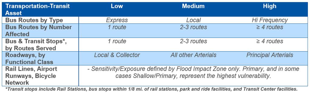
2 Today s Discussion Overview Localized Flooding (Bluespot) Approach and Limitations Methodology Transportation &Transit Analysis Potential Strategies Mapping Tool Next Steps 2


3 Climate and Regional Planning Guide the orderly and economical development of the region. Built environment as the primary contributor to climate change Energy use in our buildings Travel behaviors as a result of our development patterns Already experiencing climate change impacts in our region to which we need to adapt 3


4 Why Conduct a Climate Vulnerability Assessment? Sustainability Outcome Integrating climate mitigation, adaptation, and resilience into the Council s management of regional systems and supporting local governments in their planning and implementation. Building in Resilience Land Use Policy Develop local resiliency to the impacts of climate change. The Council will identify and address potential vulnerabilities in regional systems as a result of increased frequency and severity in temperature, precipitation, and extreme weather.


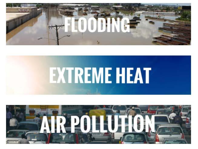
5 Assessing the Vulnerability of the Built Environment Climate impacts related to: Rain Floodways and localized flooding Temperature Urban Heat Island (UHI) Two pronged approach: 1. Assess our regional systems and assets Strategies to address vulnerabilities 2. Develop tools & suggested strategies applicable for local governments 5
6 Why Rain & Heat? Climate Change Trends in Minnesota through 2099 Hazard Projections Through 2099 Confidence in Projected Changes Warming Winters Extreme Rainfall Continued loss of cold extremes and dramatic warming of coldest conditions Continued increase in frequency and magnitude; unprecedented flash-floods Highest Heat Waves Drought Heavy Snowfall Severe Thunderstorms & Tornadoes 6 SOURCE: MN DNR State Climatology Office. More hot days with increases in severity, coverage, and duration of heat waves More days between precipitation events, leading to increased drought severity, coverage, and duration Large events less frequent as winter warms, but occasional very large snowfalls More super events possible, even if frequency decreases High Moderately High Moderately Low
7 Project Timeline 2015 CDC Work Plan Item 2017 LUAC Human Vulnerability Presentation COW Update and Discussion CONTINUED PROJECT DEVELOPMENT 2016 COW Climate Change Presentation Met Council Earth Day Presentation LUAC Scoping Discussion CDC Project Update 7


8 CVA is an Integrated Project Core Team Members CD Eric Wojchik ES Emily Resseger CD Paul Hanson Technical Experts ES Wastewater ES Water Supply ES Water Resources CD Parks MTS MT Rail and Bus Safety MT Street Operations MT Rail Operations MT Track Department MT Facilities Metro HRA Additional Partners & Support Macalester College U of MN University of St. Thomas MAC MDH MnDOT City of Minneapolis White House Office of Science & Technology Ramsey County/St. Paul MN State Climatology Office 8
9 What are We Assessing? System or Focus Assets Council Role Council-owned Housing Housing Owns & Maintains Facilities Buildings & Structures Owns & Operates Land Use N/A Planning & Collaboration with Transit Transportation Regional Parks & Trails Wastewater Water Quality Water Supply LRT, Bus Network, Metro Mobility, & Commuter Rail N/A N/A Wastewater Treatment Plans, Interceptor Pipes, Lift Stations, Maintenance Holes N/A N/A Stakeholders Owns & Operates; Collaboration with Stakeholders Planning & Collaboration with Stakeholders Planning & Collaboration with Implementing Agencies Owns & Operates Planning & Collaboration with Stakeholders Planning & Collaboration with Stakeholders 9
10 Localized Flooding (Bluespot) Approach and Limitations

11 Observation of Mega Rain Events* in MN Over half of Mega Rain Events since 1866 occurred since 2002 Challenges Most infrastructure planned for 5 to 10 year storm events Under new modelling, the 100-year event has increased by 25% *Defined as 6 or greater rains covering at least 1000sq mile and a peak amount of 8 or greater 11 IMAGE SOURCE: City of St. Louis Park

 Uses existing")

12 How to Assess Localized Flooding? Danish Road Institute (Bluespot) Uses existing GIS data Level 1 Screening Level 2 Rain Sensitivity Level 3 Modelling 12

13 Indianapolis & Bluespot 13

14 Localized Flooding (Bluespot) Council Approach Create localized flooding data layer from existing data Keep data simple to allow for broad application Group flood depth hazards to assist in screening Council assets IMAGE SOURCE: Twitter, Lowry Ave, NE Minneapolis, 7/5/

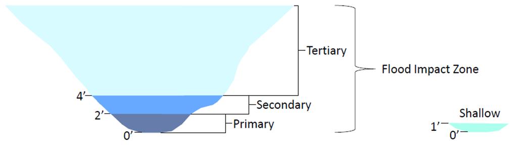
15 Localized Flooding Example Cross-section of a Bluespot 15

16 Flood Hazards SOURCE: National Weather Service,

17 Council Bluespot Categorization 17

18 How is Potential Vulnerability Shown? In or Out Vulnerability Weighted Vulnerability 18
19 Limitations of Localized Flooding Analysis Data Limited data No regional stormwater infrastructure data No information on locally-owned infrastructure Detention basins and stormwater ponds included Analysis is static represents a snapshot in time Elevation data is from 2011 IMAGE SOURCE: MC Staff, 38 th Street & Stevens Ave, 6/11/

20 Limitations of Localized Flooding Analysis Discretion Flood Impact Zones based on Council assets Therefore: The data is best used for screening and prioritization, should be considered as potential vulnerability in the event of stormwater infrastructure failure More site-specific analysis should incorporate other data IMAGE SOURCE: MC Staff, 38 th Street & Stevens Ave, 6/11/
21 Transportation & Transit Analysis Proposed Actions


22 Transportation & Transit Format for Analysis of Each Asset Asset Overview Local Example Rationale GIS Methodology Analysis Considerations Existing Strategies Proposed Strategies MC Strategies Local Strategies IMAGE SOURCE: MnDOT 22

23 Transportation & Transit Method 23
24 Transportation & Transit 82.6% of Assets Outside Flood Impact Zone 24
25 Transportation & Transit Overview Findings 25

26 Transportation & Transit Overview Findings 26


27 Regional Highway System Potential Flood Vulnerability Overview Analysis High & Very High Potential Flood Vulnerability Arterial Centerline Miles by County 27

28 Regional Highway System Local Example Potential Localized Flood Vulnerability at Major Regional Junction
29 Regional Highway System Proposed Strategies Council to conduct arterial assessment of vulnerable areas through collaboration with relevant road authority and stakeholders Council to collaborate with relevant authorities and stakeholders to increase surface water infiltration, through green infrastructure practices where possible, in potential vulnerable areas Council to plan for re-routing and alternative routes with agency and community partners Council to facilitate creation of a regional notification of road rerouting, similar to the Hennepin County Transportation Map

30 LRT/Commuter Rail Overview Analysis LRT & Commuter Rail Potential Flood Vulnerability

31 Metro Blue LRT Potential Flood Vulnerability 31

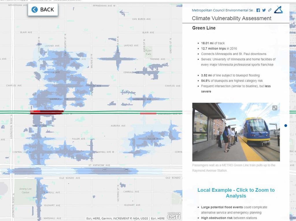
32 Metro Green LRT Potential 32 Flood Vulnerability

33 Northstar Commuter Rail Potential Flood Vulnerability 33
34 LRT/Commuter Rail Proposed Strategies Metro Transit/BNSF to perform site review and audit of all Shallow & Primary rail segments Metro Transit staff to document all flood areas that disrupt LRT operations and compare these to localized flooding data Metro Transit to enact protocols for relief transit vehicles in advance of forecasted severe storms Metro Transit to assess localized flooding impacts on rail operations hardware using technical structure specifications for water infiltration Metro Transit to work with local jurisdictions and stakeholders to enact stormwater best management practices and ongoing maintenance in jurisdiction s right-of-way along LRT and Commuter transit corridors Metro Transit to prioritize vulnerable station areas to communicate localized flooding potential to riders in a variety of formats and languages


35 Bus Transit Overview Analysis Bus Routes & Stops - Potential Flood Vulnerability High Vulnerability Bus Routes by Number of Stops in Flood Impact Zones

36 Bus Transit Portions of Bus Route 4 - Potential Localized Flood Vulnerability
37 Bus Transit Proposed Strategies Metro Transit to conduct a more detailed analysis and prioritization of all vulnerable routes and stops across the network Metro Transit to develop re-routing plans for potential vulnerable areas on a route-by-route basis Metro Transit to leverage local knowledge of experienced drivers for rerouting and temporary stop planning Metro Transit to work with relevant local stakeholders to institute volunteer adopt-a-drain programs for local bus stops, using vulnerable routes and bus stop areas for prioritization Metro Transit to prioritize vulnerable routes and bus stops to communicate localized flooding potential to riders in a variety of formats and languages

38 Aviation Potential Localized Flood Conditions is at High to Very High Vulnerability
39 Aviation Proposed Strategies Council and MAC to incorporate localized flood planning with existing riverine flood plans Council and MAC to work with local road authorities to reduce peak vulnerability on one or more access roads at St. Paul Downtown Airport

40 Regional Bicycle Transportation Network Overview Analysis Regional Bicycle Transportation Network - Potential Flood Vulnerability 40

41 RBTN Section of Midtown Greenway Potential Localized Flood Vulnerability 41
42 RBTN Proposed Strategies Council to convene a regionwide stakeholder planning group to assess the potential impacts of localized flooding on the RBTN network to inform current maintenance and future planning
43 Desired Outcomes Prioritize operations and asset management through verification of localized flooding vulnerability Manage stormwater locally, on site, as much as possible through grey and green infrastructure approaches Ensure that localized flooding takes place only where it does the least damage Ensure that public safety information is available for riders Convene a regional stakeholder group and continue collaboration 43
44 Next Steps with Transportation & Transit Relevant work units to perform more in-depth analysis of high vulnerability system assets Go beyond hazard mitigation Build equity into policies and strategies Consider this data for the next iteration of Thrive MSP

45 Mapping Tool
46 Story Map
47 Next Steps
48 Complete Project Work Additional Localized Flooding CVA (Chapters) Forthcoming: Regional Parks Facilities and Council Housing Wastewater and Water Resources Part 2: Extreme Heat Part 3: Human Vulnerability Other Deliverables: Finalized Mapping Tool (Localized Flooding & Extreme Heat) Story Map 48
49 Additional Direction Are we on the right track? Additional strategies to consider? How would you like to see future chapters? Other questions? 49
50 Any Questions? THANKS! Project Manager Eric Wojchik Local Planning Assistance
2040 Transportation Policy Plan Conversion to Performance Based Planning Basis. 25 th Annual CTS Transportation Research Conference May 21, 2014
 2040 Transportation Policy Plan Conversion to Performance Based Planning Basis 25 th Annual CTS Transportation Research Conference May 21, 2014 1 About the plan Long-range transportation plan for the Twin
RURAL RESIDENTIAL COMMUNITY ROLE COUNCIL ROLE RURAL RESIDENTIAL ALL COMMUNITIES
 Orderly and Efficient Land Use Align land use, development patterns, and infrastructure to make the best use of public and private investment. Discourage future development of rural residential patterns
2030 Transportation Policy Plan SUMMARY PRESENTATION. Land Use Advisory Committee November 15, 2012
 2030 Transportation Policy Plan SUMMARY PRESENTATION Land Use Advisory Committee November 15, 2012 Today s Topics Transportation Policy Plan (TPP) Requirements and Background Current TPP Policies, Issues
URBAN CENTER COMMUNITY ROLE COUNCIL ROLE ALL COMMUNITIES URBAN CENTER
 Orderly and Efficient Land Use Align land use, development patterns, and infrastructure to make the best use of public and private investment. Plan for forecasted population and household growth at average
LAND USE POLICIES BY COMMUNITY DESIGNATION
 137 2040 138 Land Use Policies by Community Designation As discussed earlier in Thrive MSP 2040, the Council assigns a community designation to each city and township. This designation indicates the overall
Climate Change/Extreme Weather Vulnerability and Risk Assessment for Transportation Infrastructure in Dallas and Tarrant Counties
 Climate Change/Extreme Weather Vulnerability and Risk Assessment for Transportation Infrastructure in Dallas and Tarrant Counties Yekang Ko (School of Urban and Public Affairs) With Arne Winguth & Jun
Community Development Committee Meeting date: May 18, 2009
 C E Community Development Committee Meeting date: May 18, 2009 Environment Committee Meeting date: May 26, 2009 Business Item Item: 2009-132 ADVISORY INFORMATION City of New Brighton 2030 Comprehensive
FEMA s Mitigation Support for Resiliency: Innovative Drought and Flood Mitigation Projects
 FEMA s Mitigation Support for Resiliency: Innovative Drought and Flood Mitigation Projects Jordan Williams, CFM Eric Kenney, PE, CFM May 4, 2017 2 Hazard Mitigation Purpose: Research climate resilient
Appendix D: Functional Classification Criteria and Characteristics, and MnDOT Access Guidance
 APPENDICES Appendix D: Functional Classification Criteria and Characteristics, and MnDOT Access Guidance D.1 Functional classification identifies the role a highway or street plays in the transportation
Climate Change and Resiliency: Perspectives from Metrolinx
 Climate Change and Resiliency: Perspectives from Metrolinx Dr. Quentin Chiotti Senior Advisor, Sustainability ACT CANADA SUSTAINABLE MOBILITY SUMMIT OCTOBER 31, 2017 TDM AND CLIMATE RESILIENCY: VICTORIA
HYDRAULIC HYDRODYNAMIC MODELING AS AN EFFECTIVE MANAGEMENT TOOL FOR LARGE COLLECTION SYSTEMS - THE L.A. STORY
 HYDRAULIC HYDRODYNAMIC MODELING AS AN EFFECTIVE MANAGEMENT TOOL FOR LARGE COLLECTION SYSTEMS - THE L.A. STORY Fernando Gonzalez, Adel Hagekhalil, Bryan Trussell, City of Los Angeles Bureau of Sanitation
Chapter 5: Highway Investment Direction and Plan
 5.1 Chapter 5: Highway Investment Direction and Plan 2040 2040 TRANSPORTATION POLIC PLAN version 1.0 5.2 Chapter 5: Highway Investment Direction and Plan Highway Investment Direction 3 Current Revenue
6.0 Indirect Effects and Cumulative Impacts
 6.0 Effects and Impacts 6.1 Introduction This chapter of the Draft EIS addresses potential indirect and cumulative impacts of the Bottineau Transitway project. effects are those that are caused by the
America s Climate Choices Adaptation A Challenge to the Transportation Industry
 America s Climate Choices Adaptation A Challenge to the Transportation Industry November 3, 2010 TRB Webinar H. G. Schwartz, Jr. 1 Major Factors Affecting Climate 2 MITIGATION Measures to reduce Greenhouse
TfL Managing Adaptation to Climate Change
 TfL Managing Adaptation to Climate Change 14 September 2010 Matthew Webb, Climate Change Strategy Manager TfL Group Sustainability Unit Transport for London London Underground 3m trips per day Traffic
CREATING A BLUEPRINT FOR CARGO-ORIENTED DEVELOPMENT
 Photo Credit: zman z28/flickr Creative Commons License CREATING A BLUEPRINT FOR CARGO-ORIENTED DEVELOPMENT IN THE MINNEAPOLIS M ST. PAUL REGION Metropolitan Council Meeting of the Whole, June 21 ABOUT
Chapter 8 Addressing I/I Issues and High Flows
 Chapter Outline Chapter 8 Addressing I/I Issues and High Flows This chapter is organized into the following sections: Introduction Background Estimation of Infiltration Volume Conveyance Costs Effect of
Reducing Flood Risk in Toronto. David Kellershohn, M.Eng., P. Eng. Toronto Water, City of Toronto
 Reducing Flood Risk in Toronto David Kellershohn, M.Eng., P. Eng. Toronto Water, City of Toronto Institute for Catastrophic Loss Reduction February 19, 2016 1 Agenda Reducing Flood Risk in Toronto 1) Overview
Sustainability. Sustainability Principles. 1. Framework. Spokane Transit s definition of Sustainability is:
 Sustainability Spokane Transit s definition of Sustainability is: Sustainability at Spokane Transit is about providing services in ways that optimize our ability to meet the needs of present and future
Construction Alternative Screening with Regional Travel Demand Model
 Construction Alternative Screening with Regional Travel Demand Model By: Marty Milkovits (Corresponding Author) Cambridge Systematics, Inc. 100 CambridgePark Drive, Suite 400 Cambridge, MA 02140 Phone:
Climate Change Resiliency Program
 Climate Change Resiliency Program Presentation to FMCB March 20, 2017 Winter of 2015 -- Winter Resiliency Winter 2015 revealed very disruptive vulnerabilities in MBTA operations Response to Winter 2015
Regional Transportation Studies Regional Council
 Pima Association of Governments 1 E. Broadway, Tucson, Arizona Santa Rita Conference Room Regional Transportation Studies Regional Council September 28, 2017 I-11 Tier 1 Environmental Impact Statement
Incorporating Green Infrastructure for Stormwater Management at Airports
 Airport Cooperative Research Program Project Panel 02-62: Incorporating Green Infrastructure for Stormwater Management at Airports Eduardo N. Tovar, PE TX Manager Systems Performance DFW International
Section 2: Watershed Characteristics and Runoff
 Section 2: Watershed Characteristics and Runoff The hydrology of the Wissahickon Creek and its tributaries varies greatly from place to place within the larger watershed. Stormwater management planning
ADAPTATION SYMPOSIUM Nicole Legault Environmental Policy Directorate Transport Canada
 ADAPTATION SYMPOSIUM 2016 Nicole Legault Environmental Policy Directorate Transport Canada April 13, 2016 PURPOSE Explore key risks and opportunities for the transportation sector from a changing climate
New York State DOT Adaptation to Climate Change and Extreme Weather. Elisabeth Lennon New York State Department of Transportation
 New York State DOT Adaptation to Climate Change and Extreme Weather Elisabeth Lennon New York State Department of Transportation Union College, January 2014 New York State Transportation is A vast and
STATE OF MINNESOTA Office of the State Auditor
 STATE OF MINNESOTA Office of the State Auditor Rebecca Otto State Auditor METRO TRANSIT MINNEAPOLIS, MINNESOTA AGREED-UPON PROCEDURES FOR THE YEAR ENDED DECEMBER 31, 2011 Description of the Office of the
Metropolitan Council: Climate, Emissions, & Energy. March 2, 2016
 Metropolitan Council: Climate, Emissions, & Energy March 2, 2016 Agenda Climate Change in our Own Backyard Climate Change in MN: Understanding our Role Framing the Work We Do Emissions Mitigation & Climate
Sustaining the region s waters, sustaining the region.
 2040 Sustaining the region s waters, sustaining the region. ONE VISION, ONE METROPOLITAN REGION 2040 The 2040 Water Resources Policy Plan is a framework for building strategies that integrate wastewater,
TRANSPORTATION ADVISORY BOARD. Metropolitan Council, 390 Robert Street North, Saint Paul, Minnesota 55101
 TRANSPORTATION ADVISORY BOARD 1) Call to Order 2) Adoption of Agenda Metropolitan Council, 390 Robert Street North, Saint Paul, Minnesota 55101 NOTICE OF A MEETING of the PLANNING COMMITTEE NOTE THE TIME
3. STATION SPACING AND SITING GUIDELINES
 3. STATION SPACING AND SITING GUIDELINES The station spacing and siting guidelines are summarized in Table 3-1. Table 3-1 also includes benchmark information for local transit service and express bus as
Climate Change Resiliency Planning at UHN
 Climate Change Resiliency Planning at UHN Ed Rubinstein Health Care Climate Change Resiliency Webinar Canadian Coalition for Green Health Care March 2, 2017 Who Is UHN? Toronto, Ontario, Canada 3 acute
Mike Jastremski, CFM Watershed Conservation Director
 Planning for Flood Resilient and Fish Friendly Road-Stream Crossings in CT s Northwest Hills Mike Jastremski, CFM Watershed Conservation Director Presentation Outline Project area Climate threats Field
SOUTHEAST FLORIDA REGIONAL COMPACT CLIMATE CHANGE. Sustainable Communities & Transportation Planning
 SOUTHEAST FLORIDA REGIONAL COMPACT CLIMATE CHANGE Draft Regional Climate Action Plan Sustainable Communities & Transportation Planning SP-1 Develop criteria in collaboration with municipal and county planning
S-09: Auburn Station Access Improvements
 Project Number S-09 Subarea South King Primary Mode Commuter Rail Facility Type Infrastructure Improvements Length Version Number ST Board Workshop Date Last Modified 11-25-2015 PROJECT AREA AND REPRESENTATIVE
State of Climate Change Science and Practice in Ontario. Fabio Tonto, Project Manager Edmundo Fausto, Project Manager
 State of Climate Change Science and Practice in Ontario Fabio Tonto, Project Manager Edmundo Fausto, Project Manager Today s Purpose Discuss The Issues and Risks Current Methods Updated Frameworks to Mitigate
Twin Cities Regional Truck Corridors Study. MnDOT Metro Freight Studies Roundup
 Twin Cities Regional Truck Corridors Study MnDOT Metro Freight Studies Roundup February 3, 2017 Study Background Transportation Policy Plan Goal: The regional transportation system supports the economic
CLIMATE CHANGE ADAPTATION IN MASSACHUSETTS
 CLIMATE CHANGE ADAPTATION IN MASSACHUSETTS Kathleen Baskin, Director of Water Policy June 3, 2013 MA Global Warming Solutions Act of 2008 Mitigation Reduce greenhouse gas emissions below 1990 levels by
1 Metro Vancouver Case Study Vancouver Sewage Area Infrastructure Vulnerability to Climate Change
 1 Metro Vancouver Case Study Vancouver Sewage Area Infrastructure Vulnerability to Climate Change 1.1 Background Within the First National Engineering Vulnerability Assessment, the Public Infrastructure
Joint Report of the Transportation and Management Committees For the Metropolitan Council meeting of March 21, 2018
 Committee Report Business Item No. 2018-59 JT Joint Report of the Transportation and Management Committees For the Metropolitan Council meeting of March 21, 2018 Subject: Southwest LRT (Green Line Extension)
GO RAIL NIAGARA SERVICE EXTENSION
 Business Case: Finch Avenue West Rapid Transit GO RAIL NIAGARA SERVICE EXTENSION INITIAL BUSINESS CASE Date: November, 2014 NOVEMBER 2015 Page 1 TABLE OF CONTENTS 1.0 Executive Summary...p.5 2.0 Introduction....p.6
I-35W Retaining Wall Design Exhibit A - Draft Scope of Work
 Background MnDOT, Metro Transit, Hennepin County, and the City of Minneapolis are in the process of developing a project for Interstate 35W between 43 rd Street in Minneapolis and 15 th Street in Minneapolis.
Developing Evaluation Criteria
 ART SUPPLY: HOW-TO GUIDE Design Your Project Step 7: Evaluate Responses Developing Evaluation Criteria ADAPTING TO RISING TIDES PROGRAM This guide helps with Developing and using a set of criteria for
Annual Transportation Performance Report 2012
 Annual Transportation Performance Report 2012 Page intentionally left blank... March 2014 Dear People and Businesses of Minnesota, I am pleased to share with you the 2012 Annual Transportation Performance
REGIONAL INDICATORS INITIATIVE
 ULI MN A National and Local Strategy for Sustainability Rick Carter, LHB Inc. An Inventory of Energy, Potable Water, Travel, Waste, and Greenhouse Gas Emissions for Twenty Minnesota Cities from 2008 to
Disasters, Environment (Water) and Risk Reduction - Aqaba Flood Management/Jordan
 and Risk Reduction - Aqaba Flood Management/Jordan") Background Disasters, Environment (Water) and Risk Reduction - Aqaba Flood Management/Jordan Prepared by: Sana a Al-Aqqad, The University of Jordan Water, Energy and Environment Center Case Outline 1.
Background Disasters, Environment (Water) and Risk Reduction - Aqaba Flood Management/Jordan Prepared by: Sana a Al-Aqqad, The University of Jordan Water, Energy and Environment Center Case Outline 1.
GreenDOT Advisory Group
 GreenDOT Advisory Group Massachusetts Department of Transportation Kick-Off Meeting 1 Leading the Nation in Transportation Excellence www.mass.gov/massdot GreenDOT Policy Development and Implementation
Preparing Stormwater Systems for Climate Change October 10 th, 2013 Monroe, MI. Leslie Yetka, Education Manager
 Preparing Stormwater Systems for Climate Change October 10 th, 2013 Monroe, MI Leslie Yetka, Education Manager lyetka@minnehahacreek.org National Climate Assessment Report 2013 Duluth, MN June, 2012 Rainfall:
TWIN PLATTE NATURAL RESOURCES DISTRICT
 TWIN PLATTE NATURAL RESOURCES DISTRICT Twin Platte NRD Multi-Jurisdictional Hazard Mitigation Plan Update Twin Platte NRD Multi-Jurisdictional Hazard Mitigation Plan Update 2016 1 INTRODUCTION This HMP
Climate Change Impact and Adaptation Assessment
 Climate Change Impact and Adaptation Assessment Projected warming (ºF) by NASA center, 2080s minus 1980s averaged across 16 GCMs under the A1B emissions scenario Cynthia Rosenzweig NASA Goddard Institute
Flooded Bus Barns and Buckled Rails: Public Transportation and Climate Change Adaptation
 Flooded Bus Barns and Buckled Rails: Public Transportation and Climate Change Adaptation Tina Hodges Federal Transit Administration September 22, 2011 Tina.Hodges@dot.gov 1 Key Themes Proactive instead
MN GreenStep Cities & Regional Indicators Project
 ULI Minnesota MN GreenStep Cities & Regional Indicators Project Regional Council of Mayors Meeting November 14th Rick Carter, FAIA, LEED Fellow Participating Cities Falcon Heights, MN St. Louis Park, MN
Project Initiation Form
 Meeting Date: The Project Initiation Form should be completed in conjunction with the Level 2 Screening Form. Process Leads and/or Planners should complete the Project Initiation Form to document coordination
Mobility and System Reliability Goal
 Mobility and System Reliability Goal Provide surface transportation infrastructure and services that will advance the efficient and reliable movement of people and goods throughout the state. Background:
Climate Change Adaptation in London. Alex Nickson, Strategy Manager Climate Change Adaptation & Water, Greater London Authority
 Climate Change Adaptation in London Alex Nickson, Strategy Manager Climate Change Adaptation & Water, Greater London Authority The comparative genetics of cities, 21 st May 2010 The London Climate Change
Adaptation: Advising Local Governments on Climate Change Vulnerability
 Local Government Commission Building Livable Communities Ahwahnee Hotel Adaptation: Advising Local Governments on Climate Change Vulnerability March 12, 2009 2 Planning for Climate Vulnerability Exec.
Congestion Management Process Update
 report Congestion Management Process Update prepared for Houston-Galveston Area Council prepared by Cambridge Systematics, Inc. 10415 Morado Circle, Building II, Suite 340 Austin, TX 78759 with Alliance
The Policies section will also provide guidance and short range policies in order to accomplish the goals and objectives.
 4 Goals & Objectives INTRODUCTION The 2015-2040 MTP preserves and promotes the quality of life and economic prosperity of the MAB by providing a transportation system consistent with the regional goals.
Protocol for Pre-Installation field Measurements for Prospective Living Snow Fence Sites in New York State
 Research Project C-06-09 Designing, Developing and Implementing a Living Snow Fence Program for New York State Task 3-A1 & 3-A2 Protocol for Pre-Installation field Measurements for Prospective Living Snow
This page intentionally blank.
 This page intentionally blank. Southwest LRT Project Management Signature Form System Safety and Security Management Plan Rev. 02-00 October 2015 The above referenced document is a controlled copy document,
Chapter 2 WHERE ARE WE NOW?
 T Chapter 2 WHERE ARE WE NOW? A current snapshot of Minnesota s population, economy, and environment along with information about the existing multimodal transportation system SEPTEMBER 2012 MINNESOTA
EO Information Services in support of
 EO Information Services in support of Building Exposure Maps of Urban Infrastructure and Crop Fields in the Mekong River Basin Christian Hoffmann, GeoVille group World Bank HQ, Washington DC Date : 11
Gwinnett County Stormwater System Assessment Program
 Gwinnett County Stormwater System Assessment Program Jonathan Semerjian, PE Dept. of Water Resources Stormwater Management Sam Fleming, PE Dewberry Presentation Overview Project Background Drivers Enhanced
4.1 General Methodology and Data Base Development
 Chapter 4 METHODOLOGY 4.1 General and Data Base Development This report project utilized several computer software models and analysis techniques to create the numeric data on which decisions for this
Fairfax County Countywide Transit Network Study
 Fairfax County Countywide Transit Network Study Proposed High Quality Transit Network Concept Metropolitan Washington Council of Governments Travel Forecasting Subcommittee September 20, 2013 1 Presentation
THE REGION S PLAN POLICY FRAMEWORK. August 2015
 THE REGION S PLAN POLICY FRAMEWORK August 2015 2 What is The Policy Framework? Cover photo credit: Sinan Sinharoy for Atlanta BeltLine, Inc. Atlanta is one of the world s most dynamic metropolitan areas,
Transit Cooperative Research Program TCRP A-41: Improving the Resilience of Transit Agencies Threatened by Natural Disasters
 Transit Cooperative Research Program TCRP A-41: Improving the Resilience of Transit Agencies Threatened by Natural Disasters APTA 2016 Multimodal Operations Workshop Calgary, Alberta Presentation Overview»
Virginia Tech Hazard Mitigation Plan
 Virginia Tech Hazard Mitigation Plan October 2006 Purpose of the Plan Virginia Tech Hazard Mitigation Plan Executive Summary Disasters can impact universities in a multitude of ways. In addition to the
INTEGRATING CLIMATE CHANGE INTO SCENARIO PLANNING: CAN EMISSION REDUCTION MEASURES ALSO MAKE A REGION MORE RESILIENT? 1
 INTEGRATING CLIMATE CHANGE INTO SCENARIO PLANNING: CAN EMISSION REDUCTION MEASURES ALSO MAKE A REGION MORE RESILIENT? 1 Benjamin Rasmussen, Corresponding Author US Department of Transportation Volpe National
Preliminary Drainage Analysis
 Preliminary Drainage Analysis Tanimura and Antle Employee Housing Town of Spreckels County of Monterey, California LIB150205 May 29, 2015 Prepared For: Tanimura and Antle Produce Prepared By: 9699 Blue
The newly updated and comprehensive SWMP shall:
 RFQ SCOPE OF SERVICES 2.1 Project Purpose The City of Miami, ( City ) is seeking professional engineering services from a qualified firm for the purpose of planning and developing a newly updated and comprehensive
STATE OF MINNESOTA MINNESOTA POLLUTION CONTROL AGENCY FINDINGS OF FACT
 p-ear2-44b STATE OF MINNESOTA MINNESOTA POLLUTION CONTROL AGENCY IN THE MATTER OF THE DECISION ON THE NEED FOR AN ENVIRONMENTAL IMPACT STATEMENT FOR THE PROPOSED RANDY S SANITATION TRANSFER FACILITY PROPOSED
MECKLENBURG COUNTY HAZARD MITIGATION PLAN
 MECKLENBURG COUNTY HAZARD MITIGATION PLAN 2010 Plan Update Adopted By: Mecklenburg County City of Charlotte Town of Cornelius Town of Davidson Town of Huntersville Town of Matthews Town of Mint Hill Town
(1) Bridge, Road and Railway (Adaptation Project) (2) Bridge, Road and Railway (BAU Development with Adaptation Options)
 Bridge, Road and Railway (Adaptation Project) (2) Bridge, Road and Railway (BAU Development with Adaptation Options)") Sub-sector Guideline: (1) Bridge, Road and Railway (Adaptation Project) (2) Bridge, Road and Railway (BAU Development with Adaptation Options) Basic Concept A. General Concept Climate change will increase
Sub-sector Guideline: (1) Bridge, Road and Railway (Adaptation Project) (2) Bridge, Road and Railway (BAU Development with Adaptation Options) Basic Concept A. General Concept Climate change will increase
PLEASE do not reuse without permission from NYCDEP. [Please notify Pinar Balci and Alan Cohn
 PLEASE do not reuse without permission from NYCDEP. [Please notify Pinar Balci (PBalci@dep.nyc.gov) and Alan Cohn (AlanC@dep.nyc.gov) if you intend to use any of these slides, and indicate where and when
Climate Change Adaptation Strategies for Infrastructure Managers
 Climate Change Adaptation Strategies for Infrastructure Managers Green Streets and Highways Conference November 17, 2010 Butch Wlaschin Office of Asset Management Federal Highway Administration U.S. Department
1.1.1.b. Agencies share best practices as they integrate COMPASS facilitates
 Transportation Goals 1.1 Enhance the system to improve accessibility and connectivity to jobs, schools, and services; allow the efficient movement of people and goods; and ensure the reliability of travel
Vision 2030: The resilience of water supply and sanitation in the face of climate change Chee-Keong CHEW 28 October 2009
 Vision 2030: The resilience of water supply and sanitation in the face of climate change Chee-Keong CHEW 28 October 2009 1 Scope Why climate resilience is important? Overview of Vision 2030 Summary of
Odor Monitoring and Mitigation at the Hennepin County Waste to Energy Facility
 Odor Monitoring and Mitigation at the Hennepin County Waste to Energy Facility Prepared by Jake M. Smith Senior Environmentalist Hennepin County Environmental Services 417 N 5 th St #200 Minneapolis, MN
South Sounder Capital Improvements Program
 South Sounder Capital Improvements Program Subarea South King/Pierce Primary Mode Commuter Rail Facility Type Infrastructure Improvement Length Version Draft ST3 Plan Date Last Modified March 28, 2016
Field Operations Department Wastewater Operations & Maintenance Update
 Field Operations Department Wastewater Operations & Maintenance Update Wastewater Advisory Committee June 2009 Today s Agenda Organization Equipment and Facility Maintenance Process Control and Project
Climate Change Impacts and Adaptation for Coastal Transport Infrastructure in the Caribbean
 UNCTAD Regional Workshop 5 7 December 2017, Bridgetown, Barbados Climate Change Impacts and Adaptation for Coastal Transport Infrastructure in the Caribbean Identifying operational thresholds for vulnerability
Challenges in Seoul Metropolitan for restoring urban water cycle
 Challenges in Seoul Metropolitan for restoring urban water cycle Reeho Kim*, Seung Won Lee, Jung-hun Lee Daehee Lee, Muhammad Shafique Korea Institute of Civil Engineering and Building Technology 1 Table
FEMA s National Risk Index
 FEMA s National Risk Index Agenda National Risk Index (NRI) Background NRI Working Groups Calculating and NRI Hazard Data Resilience Score Social Vulnerability and Resilience Data Built Environment Data
Using GIS to Inventory and Map Rapid City, South Dakota s Major Drainage Elements
 Using GIS to Inventory and Map Rapid City, South Dakota s Major Drainage Elements Jenifer Sorensen, PE, PhD FourFront Design, Inc. Dion Lowe, PE City of Rapid City Stormwater Program Stormwater - Definition
Wastewater System Master Plan and SSO Initiative
 Wastewater System Master Plan and SSO Initiative Project Drivers Rapid Population Growth in Fort Worth 800000 700000 46% Increase in Population Over the Last 10-Years 702,850 600000 Population 500000 400000
Los Angeles County Congestion Reduction Demonstration Project
 Los Angeles County Congestion Reduction Demonstration Project frequently asked questions update #1 /august 2008 Los Angeles County Metropolitan Transportation Authority (Metro), California Department of
Resilient Dallas Update. Quality of Life & Environment Committee June 13, 2016
 Resilient Dallas Update Quality of Life & Environment Committee June 13, 2016 1 Introduction Quick update on the 100 Resilient Cities Program and a review of the progress to date Discuss the development
Smart and Resilient Cities. Stefan Denig, Center of Competence Cities, London
 Smart and Resilient Cities Stefan Denig, Center of Competence Cities, London siemens.com/answers Why Resilience? The number of natural disasters is increasing Hazard Page 2 Why Resilience? The costs of
BACKGROUND. The FasTracks Plan includes three core goals:
 BACKGROUND The Regional Transportation District (RTD) was created in 1969 by the Colorado General Assembly to develop, operate, and maintain a mass transportation system for the benefit of 2.87 million
Climate Change Vulnerability Assessment Support
 Climate Change Vulnerability Assessment Support Nelson Lee, P.Eng. Green Sky Sustainability 2017 May 11 BC EIA BEST Annual Conference Whistler, BC Walt Kelly Pogo April 22, 1970 we have met the enemy and
Climate Change: Scientific basis and risks for the finance sector
 Climate Change: Scientific basis and risks for the finance sector P. Hadjinicolaou 1,2 and C. Zerefos 1,3 1 Lab. of Climatology and Atmospheric Environment, University of Athens 2 Frederick Institute of
MEMORANDUM EXAMPLES FOR ILLUSTRATIVE PURPOSES NEXT STEPS. Item 3 Long-Range Plan Task Force May 17, 2017
 Item 3 Long-Range Plan Task Force May 17, 2017 MEMORANDUM TO: TPB Long-Range Plan Task Force FROM: Kanti Srikanth, TPB Staff Director SUBJECT: Sample list of improvement initiatives for illustrative purposes
Water Resilient Green Cities in Africa Research Project
 Water Resilient Green Cities in Africa Research Project Climate change urban vulnerability and green structures : Barriers & opportunities for low income communities Urbanization vs vulnerability of low
COON CREEK WATERSHED DISTRICT PERMIT REVIEW. Spring Lake Park Schools Westwood Middle School st Avenue NE, Spring Lake Park, MN 55432
 PAN 16-112, Westwood Middle School, Page 1 of 6 COON CREEK WATERSHED DISTRICT PERMIT REVIEW MEETING DATE: August 22, 2016 AGENDA NUMBER: 10 FILE NUMBER: 16-112 ITEM: Westwood Middle School RECOMMENDATION:
Mead Comprehensive Plan & Land Use Code Update. Project Description and Background Information Town of Mead, Colorado May 2017
 Mead Comprehensive Plan & Land Use Code Update Project Description and Background Information Town of Mead, Colorado May 2017 OBJECTIVE The PURPOSE of this presentation and the online survey is to: I.
Extreme Weather Events and State DOTs
 Extreme Weather Events and State DOTs Date: August 25, 2014 Committee: Presenter: SASHTO Michael Meyer, Parsons Brinckerhoff AASHTO EXTREME WEATHER EVENTS SYMPOSIUM Best Practices for Extreme Weather Management