Big Chetac and the Red Cedar River Watershed. Dan Zerr University of Wisconsin-Extension Natural Resource Educator
|
|
|
- Reginald Rogers
- 6 years ago
- Views:
Transcription
1 Big Chetac and the Red Cedar River Watershed Dan Zerr University of Wisconsin-Extension Natural Resource Educator

2 The Water Cycle

3 An area that all drains to a particular stream, river, lake, or ocean. Includes all surface land area, smaller streams within that watershed, and groundwater flow. Watersheds are nested within each other. Small watersheds are usually part of larger watersheds. What Is A Watershed?

4 The Red Cedar River Watershed covers most of Barron and Dunn Counties, and parts of several others. Includes many smaller subwatersheds The Red Cedar River empties into the Chippewa River south of Menomonie


5 Red Cedar River Watershed Is Part of Other, Larger Watersheds Part of Red the Lower Cedar Chippewa River Watershed River Watershed Map Courtesy of US EPA

6 Mississippi River Watershed
7 Human Impacts Within a Watershed Historic land cover in the basin was mostly forest with some prairie-oak savanna Since settlement, much of historic cover was lost, replaced by agriculture and grazing land, and reservoirs were created by placing dams on the river

8 Human Impacts Within a Watershed


9 Water Quality Problems in The Red Cedar River Watershed Photos Courtesy of WDNR
 WDNR")


10 What s All That Green Stuff? Algae, cyanobacteria (blue-green algae) WDNR Photosynthetic organisms that, just like plants, need nitrogen and phosphorus to function Is naturally in our waters, but too much nitrogen and phosphorous cause algae to increase dramatically known as an algal bloom


11 Why is Algae Bad For Water Quality? Looks terrible! Who wants to swim in that? Cyanobacteria (blue-green algae) produce toxins that are harmful to animals, including humans Some people are more sensitive than others and may react with respiratory distress during a severe algal bloom Photos Courtesy of WDNR


12 Why is Algae Bad For Water Quality? Decreases dissolved oxygen in the water, leading to fish kills Can raise ph, which some aquatic organisms can t tolerate Bad for economy (less fishing, less swimming, etc.) WDNR

13 What Is Phosphorus? A natural element present in rocks and soil Is also present in water, usually attached to soil particles suspended in the water Is a key component of living organisms, including plants and algae, and is found in DNA and in the membranes of cells Treehugger.com Component of inorganic fertilizers, manure, and also human and pet waste

14 The Phosphorus Cycle Treehugger.com

15 How is Phosphorus Getting In The Water? Surface runoff o Rainwater washes over land and runs into streams and lakes, carrying soil, excess fertilizer, manure, pet waste and other pollutants with it


16 How is Phosphorus Getting In The Water? Many Sources o Farm fields o Lawns & Yards o City streets o Failing septic systems o Livestock operations o Eroding shorelines and banks o Waste water treatment plants o Legacy phosphorus
17 1,920 acre drainage lake Mean depth of 14 ft, maximum depth of 28 ft Watershed = 40 square miles, mostly forest Historically white pine, oak, aspen Various dams were built on the chain of lakes beginning in the 1880s. Big Chetac Lake

18 Big Chetac Lake - Sedimentation The mean sedimentation rate for the lake has been about average for WI over the last 200 years. Spike in sedimentation in 1910 likely due to land flooding as a result of damming. Spike in 1940 more mysterious. May be from agricultural land and huge runoff event. Besides the spikes, sedimentation rate has been fairly constant for the last 150 years. Data and graph from PALEOECOLOGICAL STUDY OF LAKE CHETAC, SAWYER COUNTY Paul J Garrison and Gina D. LaLiberte

19 Big Chetac Lake Curly-leaf Pondweed Recent infestations of curlyleaf pondweed, occurring in about 35% of the lake s surface Invasive species that outcompetes native species and can dominate the plant community Dies off in mid-summer, releasing nitrogen and phosphorus into the water column, which helps feed algae blooms Once established, can be very difficult to completely eliminate Photo: Curly-leaf pondweed, Vic Ramey, University of Florida Chetac CLP data from Aquatic Macrophyte Survey for Chetac Lake Sawyer County, Wisconsin, Endangered Resource Services, LLC


20 Big Chetac Lake - Phosphorus Total Phosphorus loading to Big Chetac from various sources (lbs/year) Data and graphics from Comprehensive Lake Management Plan, by SEH, 2010
 Phosphorus released from lake sediments when bottom of lake goes anoxic Mixing and aeration can alleviate some of this, but only on a limited scale Dredging and removal of sediments")
21 What Can Be Done? Sediments (69%) Phosphorus released from lake sediments when bottom of lake goes anoxic Mixing and aeration can alleviate some of this, but only on a limited scale Dredging and removal of sediments will remove P, but is very costly and very disruptive Alum treatment can lock P in the sediments, but is very expensive, and other sources of P should be minimized first KeywordPictures.com
 CLP pulls phosphorus from the sediment and water column, and then releases it again when it dies in mid-summer, which is a")
 Harvesting with aquatic plant harvesters can help, but is expensive, long-term, and")
22 What Can Be Done? CLP (15%) CLP pulls phosphorus from the sediment and water column, and then releases it again when it dies in mid-summer, which is a critical time for algae blooms Can be treated with herbicides which can help control it, but requires the use of chemicals in the lake for several years (turions are hard to kill) Harvesting with aquatic plant harvesters can help, but is expensive, long-term, and can spread the plant by creating fragments Photo: CLP turions, courtesy of UW-La Crosse Photo: SaveTheYaphankLakes.org
 Tributaries will always provide some P inputs Make sure all is being done on managed land to minimize runoff of soil, manure, fertilizers")
23 What Can Be Done? Tributaries (6%) Tributaries will always provide some P inputs Make sure all is being done on managed land to minimize runoff of soil, manure, fertilizers Agricultural practices should include buffers, conservation tillage, nutrient management Minimize intense logging near streams Photo courtesy of UW-La Crosse


24 What Can Be Done? Lake Residents Maintain septic systems and repair if failing Plant rain gardens next to downspouts to infiltrate runoff from rooftops, and/or use rain barrels to collect rainwater Plant vegetated buffers near shorelines to minimize runoff into the lake and promote natural shorelines resistant to erosion

25 What Can Be Done? Use phosphorus-free products fertilizers (or go without!) dishwasher detergent laundry detergent Photo Courtesy of USGA


26 What Can Be Done? Keep leaves, grass clippings and other pollutants from the rivers and lakes, and from storm drains and ditches Pick up after your pets Use proper erosion control on construction sites Photo Courtesy of Sandy, UT
27 What Can Be Done? Network and partner with other individuals or groups who may be working on water quality issues and events Talk to your local and state government officials about the need for proper resources to address the problems

28 What Can Be Done? Talk to your family and friends about what you learn and what you re doing to help Participate in clean-ups and other events designed to keep our environment, including our lakes and rivers, clean and sustainable

29 What Can Be Done? Remember, water is life, and we need to keep it clean and available for everyone!

30 Daniel Zerr Natural Resources Educator UW-Extension Questions
BLACK OTTER LAKE DISTRICT
 BLACK OTTER LAKE DISTRICT Storm water Action Plan Action Plan submitted for UW-Madison Course 272630 JDD001 #41967 Great Lakes Water Stewardship Institute 2012 Hortonville Area School District Hortonville
Wakefield Lake TMDL Public Meeting 3/17/2014. Jen Koehler, PE Barr Engineering
 Wakefield Lake TMDL Public Meeting 3/17/2014 Jen Koehler, PE Barr Engineering Outline Project Contacts Introduction to Wakefield Lake Thoughts/Questions/Concerns About TMDL Studies Lake Water Quality and
Potato Lake 2010 Project Results and APM Plan. Saturday May 28, 2011 Dave Blumer, Jake Macholl SEH Lake Scientists
 Potato Lake 2010 Project Results and APM Plan Saturday May 28, 2011 Dave Blumer, Jake Macholl SEH Lake Scientists Lake and Aquatic Plant Management Planning Goal: To maintain or improve the overall condition
Welcome. Thank you for joining us! Lower Mississippi River Watershed Management Organization
 Welcome. Thank you for joining us! Lower Mississippi River Watershed Management Organization Lower Mississippi River Watershed Management Organization Watershed Restoration and Protection (WRAP) Study
Hubbard County Water Quality and You Celebrating 20 Years of Water Quality Testing in Hubbard County!
 Hubbard County Water Quality and You Celebrating 20 Years of Water Quality Testing in Hubbard County! A Collaborative Effort by: Citizen Volunteers Hubbard County Coalition of Lake Associations (HC COLA)
Waterford Waterway & Tichigan Lake 2017 Water Quality and Algae Sampling Report
 Waterford Waterway & Tichigan Lake 2017 Water Quality and Algae Sampling Report September 20, 2017 Prepared for: Waterford Waterway Management District Prepared by: James Scharl 0 Toll Free: 866-208-0724
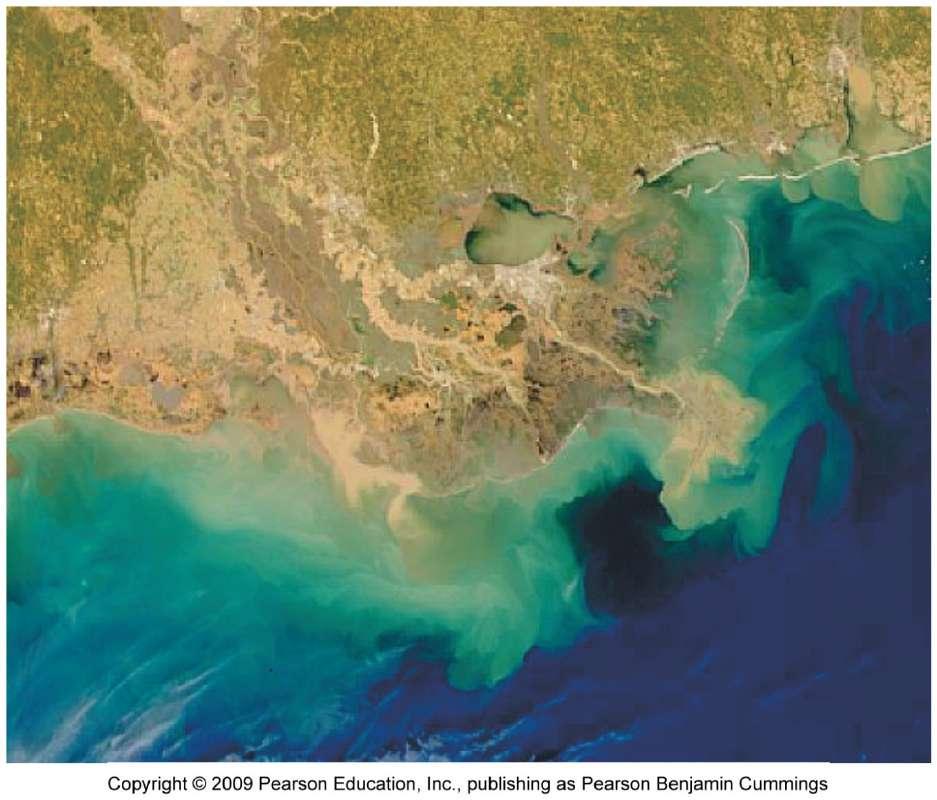
The Hypoxic Zone in the Gulf of Mexico
 The Hypoxic Zone in the Gulf of Mexico References Council Committee on Environmental and Natural Resources. 2003. An Assessment of Coastal Hypoxia and Eutrophication in U.S. Water. National Science and
Wisconsin River. Hardest Working River In the Nation
 Hardest Working River In the Nation Hardest Working River In The Nation Largest Basin In Wisconsin 430 miles in length 20% of Wisconsin, with diverse land use 14,776 mi2 catchment at Prairie du Sac Dam
Clam Lakes (Lower & Upper), Burnett County Four-Phased Lake Management Planning Project Description
, Burnett County Four-Phased Lake Management Planning Project Description") 1 Clam Lakes (Lower & Upper), Burnett County Four-Phased Lake Management Planning Project Description Lake and Watershed Characteristics The Clam Lakes are a combined 1544 acres with Upper Clam Lake essentially
1 Clam Lakes (Lower & Upper), Burnett County Four-Phased Lake Management Planning Project Description Lake and Watershed Characteristics The Clam Lakes are a combined 1544 acres with Upper Clam Lake essentially
A Summary of Efforts to Reduce Phosphorus in the Red Cedar River Basin
 A Summary of Efforts to Reduce Phosphorus in the Red Cedar River Basin State Laws to Reduce Phosphorus 1970s - Restriction on phosphorus in laundry detergent 1992 - Limits on point sources with significant
VILLAGE OF BELLAIRE WATER QUALITY ACTION PLAN
 VILLAGE OF BELLAIRE WATER QUALITY ACTION PLAN Elk-River-Chain-of-Lakes Gaps Analysis Project The Watershed Center Grand Traverse Bay Tip of the Mitt Watershed Council Michigan Department of Natural Resources
BIG ROCHE A CRI LAKE CHARACTERISTICS
 BIG ROCHE A CRI LAKE CHARACTERISTICS Lake Description Big Roche Cri Lake is located in north central Adams County and has a surface area of 205 acres, a shoreline length of 6.1 mile, a volume of 6,993
Otonabee Region WATERSHED
 Otonabee Region WATERSHED Report Card 2018 Otonabee Conservation has prepared this report card as a summary of the state of your forests, wetlands, and water resources using data from 2012 to 2016. WHERE
EUTROPHICATION. Student Lab Workbook
 EUTROPHICATION Student Lab Workbook THE SCIENTIFIC METHOD 1. Research Background literature research about a topic of interest 2. Identification of a problem Determine a problem (with regards to the topic)
The effects of pollution. What is stormwater runoff? Why is stormwater runoff a problem?
 What is stormwater runoff? Stormwater runoff occurs when precipitation from rain or snowmelt flows over the ground. Impervious surfaces like driveways, sidewalks, and streets prevent stormwater from naturally
ECOSYSTEMS, WATERSHEDS AND POLLUTION CONTROL REVIEW
 ECOSYSTEMS, WATERSHEDS AND POLLUTION CONTROL REVIEW ECOSYSTEMS: (6 th grade content) How biotic and abiotic factors make an ecosystem: https://www.youtube.com/watch?v=mdlwptkg-vi 1. A/An ecosystem is a
Orange County Fertilizer Application Education Course for Citizens
 Orange County Fertilizer Application Education Course for Citizens Thanks for taking the time to learn how to keep Central Florida beautiful while protecting our water quality! Why is Orange County Requiring
Tackling Non-point Source Water Pollution in British Columbia
 Water Quality Clean Water Tackling Non-point Source Water Pollution in British Columbia Our well-being depends on sustainable supplies of clean water for our physical health and for a healthy environment
Comfort Lake-Forest Lake Watershed District Six Lakes Total Maximum Daily Load Implementation Plan
 Prepared by: for the Comfort Lake-Forest Lake Watershed District and the Minnesota Pollution Control Agency Comfort Lake-Forest Lake Watershed District Six Lakes Total Maximum Daily Load February 16, 2010
Dirty Water. Adapted from: Dirty Water in Living in Water. National Aquarium in Baltimore, Grade Level: all. Duration: 1-2 class periods
 Dirty Water Adapted from: Dirty Water in Living in Water. National Aquarium in Baltimore, 1997. Nitrogen and Phosphorus Grade Level: all Duration: 1-2 class periods Setting: classroom or laboratory Summary:
Green County: Groundwater 101
 Green County: Groundwater 101 Kevin Masarik Center for Watershed Science and Education Through the University of Wisconsin-Extension, all Wisconsin people can access University resources and engage in
INTRODUCTION TO HOBBY FARMING AND WATER QUALITY
 SECTION ONE INTRODUCTION TO HOBBY FARMING AND WATER QUALITY This is a handbook for owners of Hobby Farms - small scale farms operated primarily as a residential lifestyle - to provide their owners with
WATERSHED. Maitland Valley. Report Card 201
 Maitland Valley WATERSHED Report Card 201 The Maitland Valley Conservation Authority has prepared this report card as a summary on the state of our forests, wetlands, surface water, and ground water resources.
Hydrology 101. Impacts of the Urban Environment. Nokomis Knolls Pond Summer June 2008
 Hydrology 101 Nokomis Knolls Pond Summer 2002 Impacts of the Urban Environment Hydrologic Cycle; What is it? Geography, Topography, Geology, Land Cover and Climate determine the Amount and Behavior of
Sliver of Our River. Grade Level: 3-5, 6-8 Academic Area(s): Science, Economics, Geography and Reading. Topic(s): Earth Science
: Science, Economics, Geography and Reading. Topic(s): Earth Science") Sliver of Our River Sliver of Our River Grade Level: 3-5, 6-8 Academic Area(s): Science, Economics, Geography and Reading Topic(s): Earth Science www.ksagclassroom.org Rev. July/2017 Overview: Students
Sliver of Our River Sliver of Our River Grade Level: 3-5, 6-8 Academic Area(s): Science, Economics, Geography and Reading Topic(s): Earth Science www.ksagclassroom.org Rev. July/2017 Overview: Students
What Does It All Mean? CWA? Sara Esposito, P.E. DNREC Division of Watershed Stewardship
 What Does It All Mean? CWA? Sara Esposito, P.E. DNREC Division of Watershed Stewardship sara.esposito@state.de.us Why are we here? Just like pavement has helped move cars faster; it has also helped water
OUR MISSION: To preserve, protect, and restore Delaware s Inland Bays the water that flows into them and the watershed around them.
 OUR MISSION: To preserve, protect, and restore Delaware s Inland Bays the water that flows into them and the watershed around them. OUR In 1988, the Delaware Inland Bays were declared an estuary of national
Eliminating Runoff Water from Your Farm
 SUSTAINABLE AGRICULTURE TECHNIQUES Ext/CrS 142 August 2012 SUSTAINABLE AGRICULTURE TECHNIQUES Eliminating Runoff Water from Your Farm J.L. Harden, K.M. Foley, C.C. Shock, and T.K. Welch Figure 1. Runoff
TORCH LAKE TOWNSHIP WATER QUALITY ACTION PLAN
 TORCH LAKE TOWNSHIP WATER QUALITY ACTION PLAN Elk-River-Chain-of-Lakes Gaps Analysis Project The Watershed Center Grand Traverse Bay Tip of the Mitt Watershed Council Michigan Department of Natural Resources
The Clean Water Act: Phase I
 Nearly 40 percent of all surveyed bodies of water in the U.S. do not meet the Environmental Protection Agency s (EPA s) water quality standards because of untreated polluted runoff that is often discharged
Red Rock Lake: A Path Forward
 University of Minnesota Morris Digital Well University of Minnesota Morris Digital Well Center for Small Towns 6-2016 Red Rock Lake: A Path Forward Colette Millard Student - University of Minnesota, Morris
Welcome. Thank you for joining us!
 Welcome. Thank you for joining us! Watershed Restoration and Protection Strategy (WRAPS) Study Implementation Workshop June 24, 2014 Lower Mississippi River Watershed Management Organization Tonight s
PROTECTING OUR WATERWAYS: STORMWATER POLLUTION REDUCTION EFFORTS
 PROTECTING OUR WATERWAYS: STORMWATER POLLUTION REDUCTION EFFORTS Public Information Meeting ~ May 2, 2018 Public Works Stormwater Management Division OVERVIEW Surface Water Quality Protection Municipal
Eutrophication: Tracing Nutrient Pollution Back to Penns Creek
 Eutrophication: Tracing Nutrient Pollution Back to Penns Creek Nutrients are substances that life depends on for growth and reproduction. However, when these nutrients enter our planets waterways in excess,
Helen Lake. Final Results Portage County Lake Study. April 5, University of Wisconsin-Stevens Point, Portage County Staff and Citizens
 Helen Lake Final Results Portage County Lake Study University of Wisconsin-Stevens Point, Portage County Staff and Citizens April 5, 2005 What can you learn from this study? You can learn a wealth of valuable
When it Rains it Pours
 Lesson Summary: Students will understand how water is absorbed into the ground. They will also be able to explain the difference between pervious and impervious surfaces. Students will also learn about
Particulate Soil Phosphorus and Eutrophication in Lakes and Streams
 Particulate Soil Phosphorus and Eutrophication in Lakes and Streams Paul R. Bloom Soil, Water, & Climate Department University of Minnesota With contributions by John Moncrief, Carl Rosen and David Mulla
Master 5.1, Newspaper Articles. Special Edition December 14. Special Edition March 17
 Master 5.1, Newspaper Articles THE DAILY HERALD Special Edition December 14 Study Forecasts Future Food Shortage A new study published in the Journal of World Agriculture raises concerns that in the future
PRESENTATION OUTLINE. Stormwater Program Update Stormwater Overview. Education Program Discussion. Sources and consequences of pollutants
 PRESENTATION OUTLINE Stormwater Program Update Stormwater Overview Sources and consequences of pollutants Education Program Discussion Why Stormwater? 1972 Clean Water Act Established permitting program
Water Assessment and Audit. Congratulations on completing Step 1 by forming your Green Team!
 School Name: Date: Conducted By: Congratulations on completing Step 1 by forming your Green Team! Step 2: Assess Complete this to learn more about the current water conservation and quality practices at
Phosphorus Kyle Minks Land and Water Resources Scientist Land Conservation Division
 Phosphorus Kyle Minks Land and Water Resources Scientist Land Conservation Division Overview Phosphorus 101 Phosphorus transport What is legacy phosphorus How phosphorus is managed to reduce environmental
Environmental Geography
 Environmental Geography Lecture 13 Water Pollution Lecture 13: Water Pollution I. Water Pollution A. Groundwater B. Surface Water C. Regulation II. Water Use in California 1 I. Water Pollution Types of
Activity 1: Using the Level of Oxygen- Saturation Chart graph Dissolved Oxygen vs. Temperature at 100% saturation. Start by making a 2 column table.
 Activity 1: Using the Level of Oxygen- Saturation Chart graph Dissolved Oxygen vs. Temperature at 100% saturation. Start by making a 2 column table. Number the first column with temperatures from 0 to
TEKS Lesson 7.8C: Effects of Human Activity on Surface Water and Groundwater
 Class ----- Date -------- TEKS Lesson 7.SC TEKS 7.8e Model the effects of human activity on groundwater surface water in a watershed. and TEKS Lesson 7.8C: Effects of Human Activity on Surface Water and
AP Lab 12--DISSOLVED OXYGEN & AQUATIC PRIMARY PRODUCTIVITY (LabBench)
") Name AP Biology AP Lab 12--DISSOLVED OXYGEN & AQUATIC PRIMARY PRODUCTIVITY (LabBench) Web address: http://www.phschool.com/science/biology_place/labbench Click on Lab 12: Dissolved Oxygen & Aquatic Primary
Name AP Biology AP Lab 12--DISSOLVED OXYGEN & AQUATIC PRIMARY PRODUCTIVITY (LabBench) Web address: http://www.phschool.com/science/biology_place/labbench Click on Lab 12: Dissolved Oxygen & Aquatic Primary
AP Environmental Science
 Name AP Environmental Science DISSOLVED OXYGEN & AQUATIC PRIMARY PRODUCTIVITY (LabBench) Web address: http://www.phschool.com/science/biology_place/labbench Click on Lab 12: Dissolved Oxygen & Aquatic
A Successful Lake Management Program for Lake Mitchell PROFESSIONAL ENGINEERS AND SCIENTISTS SPECIALIZING IN WATER RESOURCES
 A Successful Lake Management Program for Lake Mitchell PROFESSIONAL ENGINEERS AND SCIENTISTS SPECIALIZING IN WATER RESOURCES Tonight s Agenda 1. General Review of FYRA Engineering and Qualifications 2.
Small-Scale Farmers and the Environment: How to be a Good Steward
 L P E S Small Farms Fact Sheet series Livestock and Poultry Environmental Stewardship < L P E S > Curriculum : How to be a Good Steward By Mark Rice, North Carolina State University Summary Good stewardship
Healthy lakes add value to our communities. They provide a place to relax and recreate,
 Pike Lake Eastern Marathon County Lake Study Final Study Results 2013 University of Wisconsin-Stevens Point and Marathon County Staff and Citizens Healthy lakes add value to our communities. They provide
Request for Proposals Surface Water Improvement Fund Grants CUYAHOGA COUNTY ONLY 12/01/09
 STREET ADDRESS: Lazarus Government Center 50 W. Town St., Suite 700 Columbus, Ohio 43215 State of Ohio Environmental Protection Agency TELE: (614) 644-3020 FAX: (614) 644-3184 www.epa.ohio.gov Request
Pembina River Watershed Water Quality Report
 Pembina River Watershed Water Quality Report January 29 Prepared by: Manitoba Water Stewardship 16-123 Main St. Winnipeg, MB. Canada State of the Watershed Report 5OA and 5OB Pembina River Watershed -
Comparative Analysis of Minnesota Lakes Treated with Alum to Inform Spring Lake Treatment
 Comparative Analysis of Minnesota Lakes Treated with Alum to Inform Spring Lake Treatment Prepared for the Prior Lake Spring Lake Watershed District (PLSLWD) April 23, 2013 Comparative Analysis of Minnesota
LPES Small Farms Fact Sheets* Small-Scale Farmers and the Environment: How to be a Good Steward. By Mark Rice, North Carolina State University
 LPES Small Farms Fact Sheets* Small-Scale Farmers and the Environment: How to be a Good Steward By Mark Rice, North Carolina State University Summary Good stewardship is important for everyone, including
Riparian Buffers and Stream Restoration
 Riparian Buffers and Stream Restoration Why focus on riparian areas? Link land and water on any given site and link landscapes together in a watershed Riparian corridors protect the circulatory system
North Dakota s Nutrient Reduction Strategy. Presented to the 2016 ND Water Quality Monitoring Conference March 4, 2016
 North Dakota s Nutrient Reduction Strategy Presented to the 2016 ND Water Quality Monitoring Conference March 4, 2016 Nutrients Nutrients, in appropriate amounts, are essential to the growth and health
Wisconsin s Buried Treasure
 Wisconsin s Buried Treasure Kevin Masarik Center for Watershed Science and Education Through the University of Wisconsin-Extension, all Wisconsin people can access University resources and engage in lifelong
Cedar Island, Pike, and Eagle Lakes Nutrient TMDL Implementation Plan
 Cedar Island, Pike, and Eagle Lakes Nutrient TMDL Implementation Plan Wenck File #1240-76 Prepared for: SHINGLE CREEK WATERSHED MANAGEMENT COMMISSION MINNESOTA POLLUTION CONTROL AGENCY Prepared by: May
Riparian Buffer Requirements. Department of Environmental Protection Bureau of Watershed Management
 102.14 - Riparian Buffer Requirements Department of Environmental Protection Bureau of Watershed Management 102.2 Scope and Purpose BMPs to protect, maintain, and restore water quality and existing designated
What Are the Causes and Effects of Water Pollution?
 Water PolChapter 20 Ch20 Water Pollution SPARK Notes lution What Are the Causes and Effects of Water Pollution? Water pollution causes illness and death in humans and other species, and disrupts ecosystems.
Lakes and Ponds. Questions to consider. Ponds breathe. Sinkhole pond. Oxbow lake. Farm pond. Reservoir
 8 Lakes and Ponds dane johnson / visuals unlimited Oxbow lake Farm pond Sinkhole pond Reservoir albert copley / visuals unlimited Questions to consider 1 2 3 4 5 6 7 How do oxygen levels in ponds change
MURPHY DRAIN CATCHMENT
 The RVCA produces individual reports for 16 catchments in the Lower Rideau subwatershed. Using data collected and analysed by the RVCA through its watershed monitoring and land cover classification programs,
LAB. LAB BENCH DISSOLVED OXYGEN & AQUATIC PRIMARY PRODUCTIVITY
 Period Date LAB. LAB BENCH DISSOLVED OXYGEN & AQUATIC PRIMARY PRODUCTIVITY Go back to The Biology Place s Lab Bench so you can walk through the Dissolved Oxygen experiment as a virtual laboratory. Web
Nutrients and Water Quality in the East Souris River Watershed
 Nutrients and Water Quality in the East Souris River Watershed Phosphorus and nitrogen occur naturally and are important plant nutrient sources in water bodies. However, several human factors have created
Conservation Practices for Water Quality: Sediment & Nutrient Control. Trap Sediments/Trap Nutrients on the Field. Improve Soil Health.
 Conservation Practices for Water Quality: Sediment & Nutrient Control. Trap Sediments/Trap Nutrients on the Field. Improve Soil Health. Sediment Conservation Cover Cover Crop Critical Area Planting Field
Gull Lake CASS & CROW WING COUNTIES
 Gull Lake 11-0305-00 CASS & CROW WING COUNTIES Summary Gull Lake is located just northwest of Brainerd, Minnesota, on the border of Cass and Crow Wing Counties. It covers 9,947 acres, which places it in
Grants Pass Water Quality Monitoring
 Grants Pass Water Quality Monitoring 2003-2005 Rogue Valley Council of Governments April 2005 Rogue Valley Council of Governments Natural Resources Department 155 North First Street Central Point, Oregon
Our Journey Aquatic Invasive Species Eurasian Milfoil (EWM) April 23, 2015
 April 23, 2015") Our Journey 2007 2015 Aquatic Invasive Species Eurasian Milfoil (EWM) April 23, 2015 1 About Beecher Lake Name: Beecher Lake Water body Area: 30 ACRES Maximum Depth: 45 feet Bottom: 5% sand, 5% gravel,
Our Journey 2007 2015 Aquatic Invasive Species Eurasian Milfoil (EWM) April 23, 2015 1 About Beecher Lake Name: Beecher Lake Water body Area: 30 ACRES Maximum Depth: 45 feet Bottom: 5% sand, 5% gravel,
C O M P R E H E N S I V E P R O T E C T I O N & R E S T O R AT I O N P L A N. f or th e
 C O M P R E H E N S I V E P R O T E C T I O N & R E S T O R AT I O N P L A N f or th e R O S S B A R NE T T R E SERV O I R WATERS HED, MI S S I S S I P P I E X E C U T I V E S U M M A R Y O C T O B E R
Factsheet: Town of Deep River Water Quality and Stormwater Summary
 79 Elm Street Hartford, CT 06106-5127 www.ct.gov/deep Affirmative Action/Equal Opportunity Employer Factsheet: Town of Deep River Water Quality and Stormwater Summary This document was created for each
Polluted Runoff and Land Conservation: What s the Connection?
 Polluted Runoff and Land Conservation: What s the Connection? Caroly Shumway, Ph.D. Executive Director, Merrimack River Watershed Council In partnership with NMCOG Overview Purpose Of This Talk Is To Convey
2016 Data Report for Barlow Lake, Barry County
 Michigan Lakes Ours to Protect 216 Data Report for Barlow Lake, Barry County Site ID: 8176 42.67559 N, 85.5242 W The CLMP is brought to you by: 1 About this report: This report is a summary of the data
Ecosystems: Nutrient Cycles
 Ecosystems: Nutrient Cycles Greeks, Native Peoples, Buddhism, Hinduism use(d) Earth, Air, Fire, and Water as the main elements of their faith/culture Cycling in Ecosystems the Hydrologic Cycle What are
Research Background: View of a salt marsh in Plum Island Estuary. Photo by Harriet Booth.
 Urbanization and Eutrophication Featured scientists: Charles Hopkinson from University of Georgia and Hap Garritt from the MBL Ecosystems Center Research Background: An estuary is a habitat formed where
Stormwater Programs. BIA Meeting June 5, Jason Uhley
 Stormwater Programs BIA Meeting June 5, 2014 Jason Uhley Chief of Watershed Protection Riverside County Flood Control and Water Conservation District Presentation Outline Clean Water Act Stormwater Program
Clean water. From nature.
 Clean water. From nature. Natural Treatment System Save water. Do your part. Did you know that over watering or a broken sprinkler on your property can contribute to ocean pollution? Excess watering creates
Background. AEM Tier 2 Worksheet Stream & Floodplain Management. Glossary
 AEM Tier 2 Worksheet Stream & Floodplain Management Glossary Bankfull Stage: The stage at which water starts to flow over the flood plain; the elevation of the water surface at bankfull discharge. (This
Ponds: Careful of the Fish!
 Ponds: Careful of the Fish! Dr. Chuck Cichra Extension Fisheries Specialist University of Florida / IFAS SFRC - Program of Fisheries & Aquatic Sciences All Plants Need Water, Light, and Nutrients Aquatic
management STRATEGIC PLAN The Shawano Lake Watershed Management Vision
 Management Vision That Shawano Lake is a quality water body managed by watershed residents to be useable for various types of recreation. The lake contains a broad array of habitats, supports diverse communities
Chapter 2. The Great Lakes Protection Fund. Watershed Flow Regime Restoration Evaluaton Process Developing Stormwater BMP Quality Gallon Metrics
 Chapter 2 Watershed Flow Regime Restoration Evaluaton Process Developing Stormwater BMP Quality Gallon Metrics Prepared with Funding from The Great Lakes Protection Fund September 2007 Study contact: Mark
2018 NACD POSTER CONTEST Sponsored By: 2018 Theme - Watersheds: Our Water, Our Home. Fact Sheet for Parents and Educators
 Fact Sheet for Parents and Educators What is a Watershed? A watershed is land that sheds water. Water from rain or snow can flow over the land it falls on. The water can flow to a river, lake, stream or
Phosphorus Rules NR , NR 151 and NR 217 Subchapter III
 Phosphorus Rules NR 102.06, NR 151 and NR 217 Subchapter III Jim Baumann Wisconsin Department of Natural Resources james.baumann@wisconsin.gov 608/266-9277 Phosphorus 3 Rule Changes S. NR 102.06 phosphorus
Goose Lake: Beneath the Surface. an investigation into your lake s health
 Goose Lake: Beneath the Surface an investigation into your lake s health LAKE SIZE... 72 acres WATERSHED SIZE... 921 acres MAX DEPTH... 53 feet Goose Lake AVG DEPTH... 25 feet INLETS... Spring-fed OUTLETS...
GI BMP Training Program Review Worksheets
 GI BMP Training Program Review Worksheets 2/7/2013 Version 1 ANSWER KEY Instructions: Use the worksheets as a guide to review key learning points and information provided during the training program. Depending
10 Steps to Cleaner Water
 watershed stewardship action kit 10 Steps to Cleaner Water January 2006 At some point, the will to conserve our natural resources has to rise up from the heart and soul of the people citizens themselves
Cycles of Ma,er. Lesson Overview. Lesson Overview. 3.4 Cycles of Matter
 Lesson Overview Cycles of Ma,er Lesson Overview 3.4 Cycles of Matter THINK ABOUT IT A handful of elements combine to form the building blocks of all known organisms. Organisms cannot manufacture these
PHOSPHORUS MANAGEMENT PLAN 2013
 PHOSPHORUS MANAGEMENT PLAN 2013 (Algae bloom June 2012) Revision: 6 February 2013 Approved by City Council 28 Jan 13 and update 11 Feb 13 PLAN PURPOSE This phosphorus management plan defines: the existing
Streamlines V2, n2 (May 1997) A Newsletter for North Carolina Water Supply Watershed Administrators
 A Newsletter for North Carolina Water Supply Watershed Administrators") Page 1 of 5 STREAMLINES A Newsletter for North Carolina Water Supply Watershed Administrators Volume 2, Number 2 May 1997 Non-Point Source (NPS) Pollution This issue of Streamlines provides basic information
Page 1 of 5 STREAMLINES A Newsletter for North Carolina Water Supply Watershed Administrators Volume 2, Number 2 May 1997 Non-Point Source (NPS) Pollution This issue of Streamlines provides basic information
Memorandum. To: From: Date: July 10, Cc: Re: Introduction. to control. This time. primarily. excavated
 Memorandum To: From: Date: Cc: Dave Taylor, Madison Metropolitan Sewerage District Rob Montgomery July 10, 2012 Kevin Connors, Dane County Peter Hughes, USGS Re: DRAFT description of Alum treatment demonstration
Sustainability Report
 Sustainability Report Chanhassen 2013 Prepared by the Chanhassen Environmental Commission : Keith Anderson Denny Hansen Glenn Kaufmann Bob Kircher Katie Mahannah Matthew Myers Amy Wenner The City of Chanhassen
EUTROPHICATION. Teacher s Manual
 EUTROPHICATION Teacher s Manual Preface The following is a, hands on, and inquiry based lesson plan developed by COSEE Mid-Atlantic for teaching eutrophication. The National Education Science Standards
7-4 Soil. By Cyndee Crawford September 2014
 7-4 Soil By Cyndee Crawford September 2014 Soil Table of Contents 28.Chemical Weathering Lab 29.What is a Watershed? / Watershed Demo 30.Groundwater Layers Book 31.Groundwater Notes 32.What is an aquifer?
Boy Lake CASS COUNTY
 Boy Lake 11-143- CASS COUNTY Summary Boy Lake is located near Remer, MN in Cass County. It covers 3,452 acres, which places it in the upper 1% of lakes in Minnesota in terms of size. Boy Lake has two main
EFFECT OF UPSTREAM DEVELOPMENT ON THE CLEAR CREEK AREA
 EFFECT OF UPSTREAM DEVELOPMENT ON THE CLEAR CREEK AREA Technical Memorandum Farming in the Floodplain Project Prepared for May 2017 PCC Farmland Trust Photo credit: Google Earth TABLE OF CONTENTS Page
FieldDoc.org User Guide For 2017 NFWF Chesapeake Bay Stewardship Fund Applicants. Background 2. Step 1: Register for a FieldDoc account 3
 FieldDoc.org User Guide For 2017 NFWF Chesapeake Bay Stewardship Fund Applicants Table of Contents (click to go to page) Background 2 Step 1: Register for a FieldDoc account 3 Step 2: Create the Project