PROVINCIAL POLICY STATEMENT COMPARISON
|
|
|
- Alison Nelson
- 6 years ago
- Views:
Transcription
1 PROVINCIAL POLICY STATEMENT COMPARISON TRACKED CHANGES VERSION This document compares Provincial Policy Statement, 2005 and Provincial Policy Statement, Additions are shown in grey highlighting and deletions are shown in strikethrough. This document and the information contained herein are intended for illustrative purposes only. Users should refer back to the Provincial Policy Statement, 2014 when making decisions related to land use planning matters.
2
3 This publication was produced by the Ministry of Municipal Affairs and Housing. For more copies of this document, in either English or French, please contact: Ministry of Municipal Affairs and Housing Provincial Planning Policy Branch 777 Bay Street, 13 th Floor Toronto, ON M5G 2E5 Tel: or Website: ontario.ca/pps Publications Ontario Bookstore 880 Bay Street Toronto, Ontario M7A 1N or TTY number (teletypewriter): or Or on-line: Disponible en français: Déclaration de principes provinciale ISBN XXXX XXXX XXXX Queen s Printer for Ontario, 20XX
4
5 Approved by the Lieutenant Governor in Council, Order in Council No. 107/2014 This Provincial Policy Statement was issued under section 3 of the Planning Act and came into effect March 1, 2005 April 30, It replaces the Provincial Policy Statement issued May 22, 1996 and amended February 1, 1997 March 1, Materials may be available to assist planning authorities and decision-makers with implementing the policies of the Provincial Policy Statement. Please visit the Ministry website at Ontario.ca/PPS for more information.
6 TABLE OF CONTENTS Part I: Preamble... 1 Part II: Legislative Authority... 1 Part III: How to Read the Provincial Policy Statement... 1 Part IV: Vision for Ontario s Land Use Planning System... 4 Part V: Policies Building Strong Healthy Communities Managing and Directing Land Use to Achieve Efficient and Resilient Development and Land Use Patterns... 6 Settlement Areas... 7 Rural Areas in Municipalities... 9 Rural Lands in Municipalities Rural Areas in Territory Without Municipal Organization Coordination Land Use Compatibility Employment Areas Employment Areas Housing Public Spaces, Recreation, Parks, Trails and Open Space Infrastructure and Public Service Facilities Sewage, and Water and Stormwater Transportation Systems Transportation and Infrastructure Corridors Airports, Rail and Marine Facilities Waste Management Energy Supply Long-Term Economic Prosperity Energy Conservation, and Air Quality and Climate Change Wise Use and Management of Resources Natural Heritage Water Agriculture Minerals and Petroleum Mineral Aggregate Resources Cultural Heritage and Archaeology Protecting Public Health and Safety Natural Hazards Human-Made Hazards Implementation and Interpretation Figure Definitions... 35
7 Part I Preamble The Provincial Policy Statement provides policy direction on matters of provincial interest related to land use planning and development. As a key part of Ontario s policy-led planning system, the Provincial Policy Statement sets the policy foundation for regulating the development and use of land. It also supports the provincial goal to enhance the quality of life for the citizens of Ontario all Ontarians. The Provincial Policy Statement provides for appropriate development while protecting resources of provincial interest, public health and safety, and the quality of the natural and built environment. The Provincial Policy Statement supports improved land use planning and management, which contributes to a more effective and efficient land use planning system. The policies of the Provincial Policy Statement may be complemented by provincial plans or by locally-generated policies regarding matters of municipal interest. Provincial plans and municipal official plans provide a framework for comprehensive, integrated, place-based and long-term planning that supports and integrates the principles of strong communities, a clean and healthy environment and economic growth, for the long term. Land use planning is only one of the tools for implementing provincial interests. A wide range of legislation, regulations, policies and programs may also affect planning matters, and assist in implementing these interests. Part II: Legislative Authority The Provincial Policy Statement is issued under the authority of Ssection 3 of the Planning Act and came into effect on April 30, March 1, 2005 It applies to all applications, matters or proceedings. commenced on or after March 1, 2005 In respect of the exercise of any authority that affects a planning matter, Ssection 3 of the Planning Act requires that decisions affecting planning matters shall be consistent with policy statements issued under the Act. Part III: How to Read the Provincial Policy Statement AThe provincial policy-led planning system recognizes and addresses the complex inter-relationships among environmental, economic and social factors in land use planning. The Provincial Policy Statement supports a comprehensive, integrated and long-term approach to planning, and recognizes linkages among policy areas. Read the Entire Provincial Policy Statement The Provincial Policy Statement is more than a set of individual policies. It is intended to be read in its entirety and the relevant policies are to be applied to each situation. A When more than one policy is relevant, a decision-maker should read all of the relevant policies as if they are specifically cross-referenced with each other. While specific policies sometimes refer to other policies for ease of use, these cross-references do not take away from the need to read the Provincial Policy 1
8 Statement as a whole consider all of the relevant policies to understand how they work together. The language of each policy, including the Implementation and Interpretation policies, will assist decision-makers in understanding how the policies are to be implemented. While specific policies sometimes refer to other policies for ease of use, these cross-references do not take away from the need to read the Provincial Policy Statement as a whole. There is no implied priority in the order in which the policies appear. Part IV, Vision for Ontario s Land Use Planning System, provides the context for applying the Provincial Policy Statement. Implementation issues are addressed in the Implementation and Interpretation section. Consider Specific Policy Language When applying the Provincial Policy Statement it is important to consider the specific language of the policies. Each policy provides direction on how it is to be implemented, how it is situated within the broader Provincial Policy Statement, and how it relates to other policies. Some policies set out positive directives, such as settlement areas shall be the focus of growth and development. Other policies set out limitations and prohibitions, such as development and site alteration shall not be permitted. Other policies use enabling or supportive language, such as should, promote and encourage. The choice of language is intended to distinguish between the types of policies and the nature of implementation. There is some discretion when applying a policy with enabling or supportive language in contrast to a policy with a directive, limitation or prohibition. Geographic Scale of Policies The Provincial Policy Statement recognizes the diversity of Ontario and that local context is important. Policies are outcome-oriented, and some policies provide flexibility in their implementation provided that provincial interests are upheld. While the Provincial Policy Statement is to be read as a whole, not all policies will be applicable to every site, feature or area. The Provincial Policy Statement applies at a range of geographic scales. Some of the policies refer to specific areas or features and can only be applied where these features or areas exist. Other policies refer to planning objectives that need to be considered in the context of the municipality or planning area as a whole, and are not necessarily applicable to a specific site or development proposal. Policies Represent Minimum Standards The policies of the Provincial Policy Statement represent minimum standards. Within the framework of the provincial policy-led planning system, planning authorities and decision-makers may go beyond these minimum standards to address matters of importance to a specific community, unless doing so would conflict with any policy of the Provincial Policy Statement. Defined Terms and Meanings 2
9 Except for references to legislation which are traditionally italicized, other italicized terms in the Provincial Policy Statement are defined in the Definitions section. For other non-italicized terms, the normal meaning of the word applies. Terms may be italicized only in specific policies; for these terms, the defined meaning applies where they are italicized and the normal meaning applies where they are not italicized. Defined terms in the Definitions section are intended to capture both singular and plural forms of these terms in the policies. There is no implied priority in the order in which the policies appear. Guidance Material Guidance material and technical criteria may be issued from time to time to assist planning authorities and decision-makers with implementing the policies of the Provincial Policy Statement. Information, technical criteria and approaches outlined in guidance material are meant to support but not add to or detract from the policies of the Provincial Policy Statement. Relationship with Provincial Plans Provincial plans, such as the Greenbelt Plan, the Growth Plan for the Greater Golden Horseshoe and the Growth Plan for Northern Ontario, build upon the policy foundation provided by the Provincial Policy Statement. They provide land use planning policies to address issues facing specific geographic areas in Ontario. Provincial Plans are to be read in conjunction with the Provincial Policy Statement. They take precedence over the policies of the Provincial Policy Statement to the extent of any conflict, except where the relevant legislation provides otherwise. Land use planning decisions made by municipalities, planning boards, the Province, or a commission or agency of the government must be consistent with the Provincial Policy Statement. Where provincial plans are in effect, planning decisions must conform or not conflict with them, as the case may be. 3
10 Part IV: Vision for Ontario s Land Use Planning System The long-term prosperity and social well-being of Ontarians depend on maintaining Ontario depends upon planning for strong, sustainable and resilient communities for people of all ages, a clean and healthy environment, and a strong and competitive economy. Ontario is a vast province with diverse urban, rural and northern communities which may face different challenges related to diversity in population levels, economic activity, pace of growth and physical and natural conditions. Some areas face challenges related to maintaining population and diversifying their economy, while other areas face challenges related to accommodating and managing the development and population growth which is occurring, while protecting important resources and the quality of the natural environment. The Provincial Policy Statement reflects this diversity and is based on good planning principles that apply in communities across Ontario. Ontario s rich cultural diversity is one of its distinctive and defining features. The Provincial Policy Statement reflects Ontario s diversity, which includes the histories and cultures of Aboriginal peoples, and is based on good land use planning principles that apply in communities across Ontario. The Province recognizes the importance of consulting with Aboriginal communities on planning matters that may affect their rights and interests. The Provincial Policy Statement focuses growth and development within urban and rural settlement areas and away from significant or sensitive resources and areas which may pose a risk to public health and safety, while supporting the viability of rural areas. It recognizes that the wise management of development land use change may involve directing, promoting or sustaining growth development. Land use must be carefully managed to accommodate appropriate development to meet the full range of current and future needs, while achieving efficient development patterns and avoiding significant or sensitive resources and areas which may pose a risk to public health and safety. Efficient development patterns optimize the use of land, resources and public investment in infrastructure and public service facilities. These land use patterns promote a mix of housing, including affordable housing, employment, recreation, parks and open spaces, and transportation choices that facilitate pedestrian mobility increase the use of active transportation and transit before other modes of travel. They also support the financial well-being of the Province and municipalities over the long term, and minimize the undesirable effects of development, including impacts on air, water and other resources. Strong, liveable and healthy communities promote and enhance human health and social well-being, and are economically and environmentally sound, and are resilient to climate change. The Province s natural heritage resources, water resources, including the Great Lakes, agricultural lands resources, mineral resources, and cultural heritage and archaeological resources provide important environmental, economic and social benefits. The wise use and management of these resources over the long term is a key provincial interest. The Province must ensure that its resources are managed in a sustainable way to conserve biodiversity, protect essential ecological processes and public health and safety, provide for the production of food and fibre, minimize environmental and social impacts, and meet its long-term needs. It is equally important to protect the overall health and safety of the population. The Provincial Policy Statement directs development away from areas of natural and human-made hazards, where these hazards cannot be mitigated. This preventative approach supports provincial and municipal 4
11 financial well-being over the long term, protects public health and safety, and minimizes cost, risk and social disruption. Taking action to conserve land and resources avoids the need for costly remedial measures to correct problems and supports economic and environmental principles. Strong communities, a clean and healthy environment and a strong economy are inextricably linked. Long-term prosperity, human and environmental health and social well-being should take precedence over short-term considerations. The fundamental principles set out in the Provincial Policy Statement apply throughout Ontario, despite regional variations. To support our collective well-being, now and in the future, all land use must be well managed. The Vision for Ontario s Land Use Planning System may be further articulated through planning direction for specific areas of the Province issued through provincial plans, such as those plans created under the Niagara Escarpment Planning and Development Act and the Oak Ridges Moraine Conservation Act, 2001, which are approved by the Lieutenant Governor in Council or the Minister of Municipal Affairs and Housing. 5
12 Part V: Policies 1.0 Building Strong Healthy Communities Ontario is a vast province with urban, rural, and northern communities with diversity in population, economic activities, pace of growth, service levels and physical and natural conditions. Ontario's long-term prosperity, environmental health and social well-being depend on wisely managing change and promoting efficient land use and development patterns. Efficient land use and development patterns support sustainability by promoting strong, liveable, and, healthy and resilient communities, protecting the environment and public health and safety, and facilitate facilitating economic growth. Accordingly: 1.1 Managing and Directing Land Use to Achieve Efficient and Resilient Development and Land Use Patterns Healthy, liveable and safe communities are sustained by: a) promoting efficient development and land use patterns which sustain the financial well-being of the Province and municipalities over the long term; b) accommodating an appropriate range and mix of residential, (including second units, affordable housing and housing for older persons), employment (including industrial, and commercial and), institutional uses), (including places of worship, cemeteries and long-term care homes), recreational, park and open space, and other uses to meet long-term needs; c) avoiding development and land use patterns which may cause environmental or public health and safety concerns; d) avoiding development and land use patterns that would prevent the efficient expansion of settlement areas in those areas which are adjacent or close to settlement areas; e) promoting cost-effective development patterns and standards to minimize land consumption and servicing costs; f) improving accessibility for persons with disabilities and the elderly older persons by removing and/or identifying, preventing and removing land use barriers which restrict their full participation in society; and g) ensuring that necessary infrastructure, electricity generation facilities and transmission and distribution systems, and public service facilities are or will be available to meet current and projected needs; and h) promoting development and land use patterns that conserve biodiversity and consider the impacts of a changing climate Sufficient land shall be made available through intensification and redevelopment and, if necessary, designated growth areas, to accommodate an appropriate range and mix of employment opportunities, housing and other land uses to meet projected needs for a time horizon of up to 20 years. However, where an alternate time period has been 6
13 established for specific areas of the Province as a result of a provincial planning exercise or a provincial plan, that time frame may be used for municipalities within the area. Within settlement areas, sufficient land shall be made available through intensification and redevelopment and, if necessary, designated growth areas. Nothing in policy limits the planning for infrastructure and public service facilities beyond a 20-year time horizon Settlement Areas Settlement areas are urban areas and rural settlement areas, and include cities, towns, villages and hamlets. Ontario s settlement areas vary significantly in terms of size, density, population, economic activity, diversity and intensity of land uses, service levels, and types of infrastructure available. The vitality of settlement areas is critical to the long-term economic prosperity of our communities. Development pressures and land use change will vary across Ontario. It is in the interest of all communities to use land and resources wisely, to promote efficient development patterns, protect resources, promote green spaces, ensure effective use of infrastructure and public service facilities and minimize unnecessary public expenditures Settlement areas shall be the focus of growth or and development, and their vitality and regeneration shall be promoted Land use patterns within settlement areas shall be based on: a) densities and a mix of land uses which: 1. efficiently use land and resources; 2. are appropriate for, and efficiently use, the infrastructure and public service facilities which are planned or available, and avoid the need for their unjustified and/or uneconomical expansion; and 3. minimize negative impacts to air quality and climate change, and promote energy efficiency in accordance with policy 1.8; and 4. support active transportation; 5. are transit-supportive, where transit is planned, exists or may be developed; and 6. are freight-supportive; and b) a range of uses and opportunities for intensification and redevelopment in accordance with the criteria in policy , where this can be accommodated Planning authorities shall identify appropriate locations and promote opportunities for intensification and redevelopment where this can be accommodated taking into account existing building stock or areas, including brownfield sites, and the availability of suitable existing or planned infrastructure and public service facilities required to accommodate projected needs. Intensification and redevelopment shall be directed in accordance with the policies of Section 2: Wise Use and Management of Resources and Section 3: Protecting Public Health and Safety. 7
14 Appropriate development standards should be promoted which facilitate intensification, redevelopment and compact form, while maintaining appropriate levels of avoiding or mitigating risks to public health and safety Planning authorities shall establish and implement minimum targets for intensification and redevelopment within built-up areas, based on local conditions. However, where provincial targets are established through provincial plans, the provincial target shall represent the minimum target for affected areas Planning authorities shall establish and implement phasing policies to ensure that specified targets for intensification and redevelopment are achieved prior to, or concurrent with, new development within designated growth areas New development taking place in designated growth areas should occur adjacent to the existing built-up area and shall have a compact form, mix of uses and densities that allow for the efficient use of land, infrastructure and public service facilities Planning authorities shall establish and implement phasing policies to ensure the orderly progression of development within designated growth areas and the timely provision of the infrastructure and public service facilities required to meet current and projected needs Planning authorities shall establish and implement phasing policies to ensure: a) that specified targets for intensification and redevelopment are achieved prior to, or concurrent with, new development within designated growth areas; and b) the orderly progression of development within designated growth areas and the timely provision of the infrastructure and public service facilities required to meet current and projected needs A planning authority may identify a settlement area or allow the expansion of a settlement area boundary only at the time of a comprehensive review and only where it has been demonstrated that: a) sufficient opportunities for growth are not available through intensification, redevelopment and designated growth areas to accommodate the projected needs over the identified planning horizon; b) the infrastructure and public service facilities which are planned or available are suitable for the development over the long term, are financially viable over their life cycle, and protect public health and safety and the natural environment; c) in prime agricultural areas: 1. the lands do not comprise specialty crop areas; 2. alternative locations have been evaluated, and i. there are no reasonable alternatives which avoid prime agricultural areas; and ii there are no reasonable alternatives on lower priority agricultural lands in prime agricultural areas; and d) the new or expanding settlement area is in compliance with the minimum distance separation formulae; and 8
15 e) impacts from new or expanding settlement areas on agricultural operations which are adjacent or close to the settlement area are mitigated to the extent feasible. In determining the most appropriate direction for expansions to the boundaries of settlement areas or the identification of a settlement area by a planning authority, a planning authority shall apply the policies of Section 2: Wise Use and Management of Resources and Section 3: Protecting Public Health and Safety Rural Areas in Municipalities Rural areas are important to the economic success of the Province and our quality of life. Rural areas are a system of lands that may include rural settlement areas, rural lands, prime agricultural areas, natural heritage features and areas, and other resource areas. Rural areas and urban areas are interdependent in terms of markets, resources and amenities. It is important to leverage rural assets and amenities and protect the environment as a foundation for a sustainable economy. Ontario s rural areas have diverse population levels, natural resources, geographies and physical characteristics, and economies. Across rural Ontario, local circumstances vary by region. For example, northern Ontario s natural environment and vast geography offer different opportunities than the predominantly agricultural areas of southern regions of the Province Healthy, integrated and viable rural areas should be supported by: a) building upon rural character, and leveraging rural amenities and assets; b) promoting regeneration, including the redevelopment of brownfield sites; c) accommodating an appropriate range and mix of housing in rural settlement areas; d) encouraging the conservation and redevelopment of existing rural housing stock on rural lands; e) using rural infrastructure and public service facilities efficiently; f) promoting diversification of the economic base and employment opportunities through goods and services, including value-added products and the sustainable management or use of resources; g) providing opportunities for sustainable and diversified tourism, including leveraging historical, cultural, and natural assets; h) conserving biodiversity and considering the ecological benefits provided by nature; and i) providing opportunities for economic activities in prime agricultural areas, in accordance with policy In rural areas, rural settlement areas shall be the focus of growth and development and their vitality and regeneration shall be promoted When directing development in rural settlement areas in accordance with policy 1.1.3, planning authorities shall give consideration to rural characteristics, the scale of development and the provision of appropriate service levels Growth and development may be directed to rural lands in accordance with policy 1.1.5, including where a municipality does not have a settlement area. 9
16 1.1.5 Rural Lands in Municipalities PROVINCIAL POLICY STATEMENT COMPARISON When directing development on rural lands, a planning authority shall apply the relevant policies of Section 1: Building Strong Healthy Communities, as well as the policies of Section 2: Wise Use and Management of Resources and Section 3: Protecting Public Health and Safety In On rural lands areas located in municipalities, permitted uses shall relate to are: a) the management or use of resources,; b) resource-based recreational activities uses (including recreational dwellings); c) limited residential development; d) home occupations and home industries; e) cemeteries; and f) other rural land uses;. g) Recreational, tourism and other economic opportunities should be promoted Development that is compatible with the rural landscape and can be sustained by rural service levels should be promoted Development shall be appropriate to the infrastructure which is planned or available, and avoid the need for the unjustified and/or uneconomical expansion of this infrastructure Opportunities should be retained to locate new or expanding land uses that require separation from other uses Opportunities to support a diversified rural economy should be promoted by protecting agricultural and other resource-related uses and locally-important agricultural and resource areas should be designated and protected by directing non-related development to areas where it will not constrain minimize constraints on these uses Agricultural uses, agriculture-related uses, on-farm diversified uses and normal farm practices should be promoted and protected in accordance with provincial standards New land uses, including the creation of lots, and new or expanding livestock facilities, shall comply with the minimum distance separation formulae Rural Areas in Territory Without Municipal Organization In On rural areas lands located in territory without municipal organization, the focus of development activity shall be activities and land uses related to the sustainable management or use of resources and resource-based recreational activities uses (including recreational dwellings) Development shall be appropriate to the infrastructure which is planned or available, and avoid the need for the unjustified and/or uneconomical expansion of this infrastructure The establishment of new permanent townsites shall not be permitted. 10
17 In areas adjacent to and surrounding municipalities, only development that is related to the sustainable management or use of resources and resource-based recreational activity uses (including recreational dwellings) shall be permitted. unless Other uses may only be permitted if: a) the area forms part of a planning area; and b) the necessary infrastructure and public service facilities are planned or available to support the development and are financially viable over their life cycle; and c) it has been determined, as part of a comprehensive review, that the impacts of growth development will not place an undue strain on the public service facilities and infrastructure provided by adjacent municipalities, regions and/or the Province. 1.2 Coordination A coordinated, integrated and comprehensive approach should be used when dealing with planning matters within municipalities, or which across lower, single and/or upper-tier municipal boundaries, and with other orders of government, agencies and boards including: a) managing and/or promoting growth and development; b) economic development strategies; c) managing natural heritage, water, agricultural, mineral, and cultural heritage and archaeological resources; d) infrastructure, electricity generation facilities and transmission and distribution systems, multimodal transportation systems, public service facilities and waste management systems; e) ecosystem, shoreline, and watershed, and Great Lakes related issues; f) natural and human-made hazards; and g) population, housing and employment projections, based on regional market areas.; and h) addressing housing needs in accordance with provincial policy statements such as the Ontario Housing Policy Statement Planning authorities are encouraged to coordinate planning matters with Aboriginal communities Planning authorities should coordinate emergency management and other economic, environmental and social planning considerations to support efficient and resilient communities Where planning is conducted by an upper-tier municipality, the upper-tier municipality in consultation with lower-tier municipalities shall: a) identify, coordinate and allocate population, housing and employment projections for lower-tier municipalities. Allocations and projections by upper-tier municipalities shall be based on and reflect provincial plans where these exist; b) identify areas where growth or development will be directed, including the identification of nodes and the corridors linking these nodes; 11
18 c) identify targets for intensification and redevelopment within all or any of the lowertier municipalities, including minimum targets that should be met before expansion of the boundaries of settlement areas is permitted in accordance with policy ; d) where transit corridors exist or are to be developed, identify density targets for areas adjacent or in proximity to these corridors, including minimum targets that should be met before expansion of the boundaries of settlement areas is permitted in accordance with policy ; and e) identify and provide policy direction for the lower-tier municipalities on matters that cross municipal boundaries Where there is no upper-tier municipality, planning authorities shall ensure that policy is addressed as part of the planning process, and should coordinate these matters with adjacent planning authorities Land Use Compatibility Major facilities and sensitive land uses should be planned to ensure they are appropriately designed, buffered and/or separated from each other to prevent or mitigate adverse effects from odour, noise and other contaminants, minimize risk to public health and safety, and to ensure the long-term viability of major facilities. 1.3 Employment Areas Planning authorities shall promote economic development and competitiveness by: a) providing for an appropriate mix and range of employment (including industrial, commercial and institutional uses) to meet long-term needs b) providing opportunities for a diversified economic base, including maintaining a range and choice of suitable sites for employment uses which support a wide range of economic activities and ancillary uses, and take into account the needs of existing and future businesses; c) planning for, protecting and preserving employment areas for current and future uses; and c) encouraging compact, mixed-use development that incorporates compatible employment uses to support liveable and resilient communities; and d) ensuring the necessary infrastructure is provided to support current and projected needs Employment Areas Planning authorities shall plan for, protect and preserve employment areas for current and future uses and ensure that the necessary infrastructure is provided to support current and projected needs Planning authorities may permit conversion of lands within employment areas to nonemployment uses through a comprehensive review, only where it has been demonstrated 12
19 that the land is not required for employment purposes over the long term and that there is a need for the conversion Planning authorities shall protect employment areas in proximity to major goods movement facilities and corridors for employment uses that require those locations Planning authorities may plan beyond 20 years for the long-term protection of employment areas provided lands are not designated beyond the planning horizon identified in policy Housing To provide for an appropriate range and mix of housing types and densities required to meet projected requirements of current and future residents of the regional market area identified in policy 1.4.3, planning authorities shall: a) maintain at all times the ability to accommodate residential growth for a minimum of 10 years through residential intensification and redevelopment and, if necessary, lands which are designated and available for residential development; and b) maintain at all times where new development is to occur, land with servicing capacity sufficient to provide at least a 3 three-year supply of residential units available through lands suitably zoned to facilitate residential intensification and redevelopment, and land in draft approved and registered plans Where planning is conducted by an upper-tier municipality: a) the land and unit supply maintained by the lower-tier municipality identified in policy shall be based on and reflect the allocation of population and units by the upper-tier municipality; and b) the allocation of population and units by the upper-tier municipality shall be based on and reflect provincial plans where these exist Planning authorities shall provide for an appropriate range and mix of housing types and densities to meet projected requirements of current and future residents of the regional market area by: a) establishing and implementing minimum targets for the provision of housing which is affordable to low and moderate income households. However, where planning is conducted by an upper-tier municipality, the upper-tier municipality in consultation with the lower-tier municipalities may identify a higher target(s) which shall represent the minimum target(s) for these lower-tier municipalities; b) permitting and facilitating: 1. all forms of housing required to meet the social, health and well-being requirements of current and future residents, including special needs requirements; and 2. all forms of residential intensification, including second units, and redevelopment in accordance with policy ; 13
20 c) directing the development of new housing towards locations where appropriate levels of infrastructure and public service facilities are or will be available to support current and projected needs; d) promoting densities for new housing which efficiently use land, resources, infrastructure and public service facilities, and support the use of alternative transportation modes active transportation and public transit in areas where it exists or is to be developed; and e) establishing development standards for residential intensification, redevelopment and new residential development which minimize the cost of housing and facilitate compact form, while maintaining appropriate levels of public health and safety. 1.5 Public Spaces, Recreation, Parks, Trails and Open Space Healthy, active communities should be promoted by: a) planning public streets, spaces and facilities to be safe, meet the needs of pedestrians, foster social interaction and facilitate pedestrian and non-motorized movement, including but not limited to, walking and cycling active transportation and community connectivity; b) planning and providing for a full range and equitable distribution of publiclyaccessible built and natural settings for recreation, including facilities, parklands, public spaces, open space areas, trails and linkages, and, where practical, waterbased resources; c) providing opportunities for public access to shorelines; and d) considering the impacts of planning decisions on provincial parks, conservation reserves and conservation areas recognizing provincial parks, conservation reserves, and other protected areas, and minimizing negative impacts on these areas. 1.6 Infrastructure and Public Service Facilities Infrastructure, electricity generation facilities and transmission and distribution systems, and public service facilities shall be provided in a coordinated, efficient and cost-effective manner that considers impacts from climate change while to accommodateing projected needs. Planning for infrastructure, electricity generation facilities and transmission and distribution systems, and public service facilities shall be coordinated and integrated with land use planning for growth so that these they are: a) financially viable over their life cycle, which may be demonstrated through asset management planning; and b) available to meet current and projected needs Planning authorities should promote green infrastructure to complement infrastructure Before consideration is given to developing new infrastructure and public service facilities: 14
21 a) Tthe use of existing infrastructure and public service facilities should be optimized,; and b) opportunities for adaptive re-use should be considered, wherever feasible before consideration is given to developing new infrastructure and public service facilities Infrastructure and public service facilities should be strategically located to support the effective and efficient delivery of emergency management services Where feasible, ppublic service facilities, should be co-located in community hubs, where appropriate, to promote cost-effectiveness and facilitate service integration, access to transit and active transportation Sewage and, Water and Stormwater Planning for sewage and water services shall: a) direct and accommodate expected growth or development in a manner that promotes the efficient use and optimization of existing: 1. municipal sewage services and municipal water services; and 2. private communal sewage services and private communal water services, where municipal sewage services and municipal water services are not available; b) ensure that these systems are provided in a manner that: 1. can be sustained by the water resources upon which such services rely; 2. is feasible, financially viable and complies with all regulatory requirements; and 3. protects human health and the natural environment; c) promote water conservation and water use efficiency; d) integrate servicing and land use considerations at all stages of the planning process; and e) be in accordance with the servicing hierarchy outlined through policies , , and subject to the hierarchy of services provided in policies , and , allow lot creation only if there is confirmation of sufficient reserve sewage system capacity and reserve water system capacity within municipal sewage services and municipal water services or private communal sewage services and private communal water services. The determination of sufficient reserve sewage system capacity shall include treatment capacity for hauled sewage from private communal sewage services and individual on-site sewage services Municipal sewage services and municipal water services are the preferred form of servicing for settlement areas. Intensification and redevelopment within settlement areas on existing municipal sewage services and municipal water services should be promoted, wherever feasible Where municipal sewage services and municipal water services are not provided, municipalities may allow the use of private communal sewage services and private communal water services Municipalities may choose to use private communal sewage services and private communal water services, and where policy permits, individual on-site sewage services and individual on-site water services, where: 15
22 a) municipal sewage services and municipal water services are not provided; and b) the municipality has established policies to ensure that the services to be provided satisfy the criteria set out in Individual on-site sewage services and individual on-site water services shall be used for a new development of five or less lots or private residences where municipal sewage services and municipal water services or private communal sewage services and private communal water services are not provided and where site conditions are suitable for the long-term provision of such services. Despite this, individual on-site sewage services and individual on-site water services may be used to service more than five lots or private residences in rural areas provided these services are solely for those uses permitted by policy (a) and site conditions are suitable for the long-term provision of such services Where municipal sewage services and municipal water services or private communal sewage services and private communal water services are not provided, individual on-site sewage services and individual on-site water services may be used provided that site conditions are suitable for the long-term provision of such services with no negative impacts. In settlement areas, these services may only be used for infilling and minor rounding out of existing development Partial services shall only be permitted in the following circumstances: a) where they are necessary to address failed individual on-site sewage services and individual on-site water services in existing development; and or b) within settlement areas, to allow for infilling and minor rounding out of existing development on partial services provided that: site conditions are suitable for the long-term provision of such services with no negative impacts Subject to the hierarchy of services provided in policies , , and planning authorities may allow lot creation only if there is confirmation of sufficient reserve sewage system capacity and reserve water system capacity within municipal sewage services and municipal water services or private communal sewage services and private communal water services. The determination of sufficient reserve sewage system capacity shall include treatment capacity for hauled sewage from private communal sewage services and individual on-site sewage services Planning for stormwater management shall: a) minimize, or, where possible, prevent increases in contaminant loads; b) minimize changes in water balance and erosion; c) not increase risks to human health and safety and property damage; d) maximize the extent and function of vegetative and pervious surfaces; and e) promote stormwater management best practices, including stormwater attenuation and re-use, and low impact development Transportation Systems Transportation systems should be provided which are safe, energy efficient, facilitate the movement of people and goods, and are appropriate to address projected needs. 16
23 Efficient use shall be made of existing and planned infrastructure, including through the use of transportation demand management strategies where feasible As part of a multimodal transportation system, connectivity within and among transportation systems and modes should be maintained and, where possible, improved including connections which cross jurisdictional boundaries A land use pattern, density and mix of uses should be promoted that minimize the length and number of vehicle trips and support current and future use of transit and active transportation the development of viable choices and plans for public transit and other alternative transportation modes, including commuter rail and bus Transportation and land use considerations shall be integrated at all stages of the planning process Transportation and Infrastructure Corridors Planning authorities shall plan for and protect corridors and rights-of-way for infrastructure, including transportation, transit and electricity generation infrastructure facilities and transmission systems to meet current and projected needs Major goods movement facilities and corridors shall be protected for the long term Planning authorities shall not permit development in planned corridors that could preclude or negatively affect the use of the corridor for the purpose(s) for which it was identified. New development proposed on adjacent lands to existing or planned corridors and transportation facilities should be compatible with, and supportive of, the long-term purposes of the corridor and should be designed to avoid, mitigate or minimize negative impacts on and from the corridor and transportation facilities The preservation and reuse of abandoned corridors for purposes that maintain the corridor s integrity and continuous linear characteristics should be encouraged, wherever feasible When planning for corridors and rights-of-way for significant transportation, electricity transmission, and infrastructure facilities, consideration will be given to the significant resources in Section 2: Wise Use and Management of Resources Airports, Rail and Marine Facilities Planning for land uses in the vicinity of airports, rail facilities and marine facilities shall be undertaken so that: a) their long-term operation and economic role of airports is protected; and b) airports, rail facilities and marine facilities and sensitive land uses are appropriately designed, buffered and/or separated from each other, to prevent adverse effects from odour, noise and other contaminants in accordance with policy Airports shall be protected from incompatible land uses and development by: 17
24 a) prohibiting new residential development and other sensitive land uses in areas near airports above 30 NEF/NEP, as set out on maps (as revised from time to time) that have been reviewed by Transport Canada; b) considering redevelopment of existing residential uses and other sensitive land uses or infilling of residential and other sensitive land uses in areas above 30 NEF/NEP only if it has been demonstrated that there will be no negative impacts on the longterm function of the airport; and c) discouraging land uses which may cause a potential aviation safety hazard Waste Management Waste management systems need to be provided that are of an appropriate size and type to accommodate present and future requirements, and facilitate, encourage and promote reduction, reuse and recycling objectives. Planning authorities should consider the implications of development and land use patterns on waste generation, management and diversion. Waste management systems shall be located and designed in accordance with provincial legislation and standards Energy Supply Planning authorities should provide opportunities for the development of energy supply including electricity generation facilities, and transmission and distribution systems, to accommodate current and projected needs Planning authorities should promote renewable energy systems and alternative energy systems, where feasible, in accordance with provincial and federal requirements. 1.7 Long-Term Economic Prosperity Long-term economic prosperity should be supported by: a) promoting opportunities for economic development and community investmentreadiness; b) optimizing the long-term availability and use of land, resources, infrastructure, electricity generation and transmission and distribution systems, and public service facilities; c) maintaining and, where possible, enhancing the vitality and viability of downtowns and mainstreets; d) encouraging a sense of place, by promoting well-designed built form and cultural planning, and by conserving features that help define character, including built heritage resources and cultural heritage landscapes; e) promoting the redevelopment of brownfield sites; f) providing for an efficient, cost-effective, reliable multi-modal multimodal transportation system that is integrated with adjacent systems and those of other jurisdictions, and is appropriate to address projected needs to support the movement of goods and people; 18
25 e) planning so that major facilities (such as airports, transportation/transit/rail infrastructure and corridors, intermodal facilities, sewage treatment facilities, waste management systems, oil and gas pipelines, industries and resource extraction activities, and sensitive land uses are appropriately designed, buffered and/or separated from each other to prevent adverse effects from odour, noise and other contaminants, and minimize risk to public health and safety; g) providing opportunities for sustainable tourism development; h) providing opportunities to support local food, and promoting the sustainability of the agri-food sector and agri-product businesses by protecting agricultural resources, and minimizing land use conflicts; and i) promoting energy conservation and providing opportunities for increased development of generation, and conservation, alternative energy systems and renewable energy systems and alternative energy systems, including district energy.; j) minimizing negative impacts from a changing climate and considering the ecological benefits provided by nature; and k) encouraging efficient and coordinated communications and telecommunications infrastructure. 1.8 Energy Conservation, And Air Quality And Climate Change Planning authorities shall support energy conservation and efficiency, and improved air quality, reduced greenhouse gas emissions, and climate change adaptation through land use and development patterns which: a) promote compact form and a structure of nodes and corridors; b) promote the use of public transit and other alternative transportation modes active transportation and public transit in and between residential, employment (including commercial, and industrial) and institutional) uses and other areas where these exist or are to be developed; c) focus major employment, commercial and other travel-intensive land uses on sites which are well served by public transit where this exists or is to be developed, or designing these to facilitate the establishment of public transit in the future; d) focus freight-intensive land uses to areas well served by major highways, airports, rail facilities and marine facilities; e) improve the mix of employment and housing uses to shorten commute journeys and decrease transportation congestion; and f) promote design and orientation which: 1. maximizes the use of alternative or renewable energy, such as solar and wind energy, and energy efficiency and conservation, and considers the mitigating effects of vegetation.; and 2. maximizes opportunities for the use of renewable energy systems and alternative energy systems; and g) maximize vegetation within settlement areas, where feasible Increased energy supply should be promoted by providing opportunities for energy generation facilities to accommodate current and projected needs, and the use of renewable energy systems and alternative energy systems, where feasible. 19
26 1.8.3 Alternative energy systems and renewable energy systems shall be permitted in settlement areas, rural areas and prime agricultural areas in accordance with provincial and federal requirements. In rural areas and prime agricultural areas, these systems should be designed and constructed to minimize impacts on agricultural operations. 20
27 2.0 Wise Use and Management of Resources PROVINCIAL POLICY STATEMENT COMPARISON Ontario's long-term prosperity, environmental health, and social well-being depend on conserving biodiversity, protecting the health of the Great Lakes, and protecting natural heritage, water, agricultural, mineral and cultural heritage and archaeological resources for their economic, environmental and social benefits. Accordingly: 2.1 Natural Heritage Natural features and areas shall be protected for the long term The diversity and connectivity of natural features in an area, and the long-term ecological function and biodiversity of natural heritage systems, should be maintained, restored or, where possible, improved, recognizing linkages between and among natural heritage features and areas, surface water features and ground water features Natural heritage systems shall be identified in Ecoregions 6E & 7E 1, recognizing that natural heritage systems will vary in size and form in settlement areas, rural areas, and prime agricultural areas Development and site alteration shall not be permitted in: a) significant habitat of endangered species and threatened species; a) significant wetlands in Ecoregions 5E, 6E and 7E 1 ; and b) significant coastal wetlands Development and site alteration shall not be permitted in: a) significant wetlands in the Canadian Shield north of Ecoregions 5E, 6E and 7E 1 ; b) significant woodlands south and east of the Canadian Shield in Ecoregions 6E and 7E (excluding islands in Lake Huron and the St. Marys River) 1 ; c) significant valleylands south and east of the Canadian Shield in Ecoregions 6E and 7E (excluding islands in Lake Huron and the St. Marys River) 1 ; d) significant wildlife habitat; and e) significant areas of natural and scientific interest; and f) coastal wetlands in Ecoregions 5E, 6E and 7E 1 that are not subject to policy (b) unless it has been demonstrated that there will be no negative impacts on the natural features or their ecological functions Development and site alteration shall not be permitted in fish habitat except in accordance with provincial and federal requirements. 1 Ecoregions 5E, 6E and 7E are shown on Figure 1. 21
28 2.1.7 Development and site alteration shall not be permitted in habitat of endangered species and threatened species, except in accordance with provincial and federal requirements Development and site alteration shall not be permitted on adjacent lands to the natural heritage features and areas identified in policies and, 2.1.5, and unless the ecological function of the adjacent lands has been evaluated and it has been demonstrated that there will be no negative impacts on the natural features or on their ecological functions Nothing in policy 2.1 is intended to limit the ability of existing agricultural uses agricultural uses to continue. 2.2 Water Planning authorities shall protect, improve or restore the quality and quantity of water by: a) using the watershed as the ecologically meaningful scale for integrated and longterm planning, which can be a foundation for considering cumulative impacts of development; b) minimizing potential negative impacts, including cross-jurisdictional and crosswatershed impacts; c) identifying surface water features, water resource systems consisting of ground water features, hydrologic functions, and natural heritage features and areas, and surface water features including shoreline areas, which are necessary for the ecological and hydrological integrity of the watershed; d) maintaining linkages and related functions among surface water features, ground water features, hydrologic functions, and natural heritage features and areas, and surface water features including shoreline areas; e) implementing necessary restrictions on development and site alteration to: 1. protect all municipal drinking water supplies and designated vulnerable areas; and 2. protect, improve or restore vulnerable surface and ground water, sensitive surface water features and sensitive ground water features, and their hydrologic functions; e) maintaining linkages and related functions among surface water features, ground water features, hydrologic functions and natural heritage features and areas; f) promoting planning for efficient and sustainable use of water resources, through including practices for water conservation and sustaining water quality; and g) ensuring consideration of environmental lake capacity, where applicable; and h) ensuring stormwater management practices minimize stormwater volumes and contaminant loads, and maintain or increase the extent of vegetative and pervious surfaces Development and site alteration shall be restricted in or near sensitive surface water features and sensitive ground water features such that these features and their related hydrologic functions will be protected, improved or restored. 22
29 Mitigative measures and/or alternative development approaches may be required in order to protect, improve or restore sensitive surface water features, sensitive ground water features, and their hydrologic functions. 2.3 Agriculture Prime agricultural areas shall be protected for long-term use for agriculture. Prime agricultural areas are areas where prime agricultural lands predominate. Specialty crop areas shall be given the highest priority for protection, followed by Classes Canada Land Inventory Class 1, 2, and 3 soils lands, and any associated Class 4 through 7 lands within the prime agricultural area, in this order of priority Planning authorities shall designate prime agricultural areas and specialty crop areas in accordance with evaluation procedures established guidelines developed by the Province, as amended from time to time Permitted Uses In prime agricultural areas, permitted uses and activities are: agricultural uses, secondary uses, agriculture-related uses and on-farm diversified uses. Proposed new secondary uses and agriculture-related uses and on-farm diversified uses shall be compatible with, and shall not hinder, surrounding agricultural operations. These uses shall be limited in scale, and dcriteria for these uses shall may be included in municipal planning documents as recommended based on guidelines developed by the Province, or based on municipal approaches, as set out in municipal planning documents as recommended by the Province, or based on municipal approaches, which achieve the same objectives In prime agricultural areas, all types, sizes and intensities of agricultural uses and normal farm practices shall be promoted and protected in accordance with provincial standards New land uses, including the creation of lots, and new or expanding livestock facilities shall comply with the minimum distance separation formulae Lot Creation and Lot Adjustments Lot creation in prime agricultural areas is discouraged and may only be permitted for: a) agricultural uses, provided that the lots are of a size appropriate for the type of agricultural use(s) common in the area and are sufficiently large to maintain flexibility for future changes in the type or size of agricultural operations; b) agriculture-related uses, provided that any new lot will be limited to a minimum size needed to accommodate the use and appropriate sewage and water services; c) a residence surplus to a farming operation as a result of farm consolidation, provided that: 1. the new lot will be limited to a minimum size needed to accommodate the use and appropriate sewage and water services; and 2. the planning authority ensures that new residential dwellings are prohibited on any vacant remnant parcel of farmland created by the severance. The approach 23
30 used to ensure that no new residential dwellings are permitted on the remnant parcel may be recommended by the Province, or based on municipal approaches which achieve the same objective; and d) infrastructure, where the facility or corridor cannot be accommodated through the use of easements or rights-of-way Lot adjustments in prime agricultural areas may be permitted for legal or technical reasons The creation of new residential lots in prime agricultural areas shall not be permitted, except in accordance with policy (c) Removal of Land from Prime Agricultural Areas Planning authorities may only exclude land from prime agricultural areas for :a) expansions of or identification of settlement areas in accordance with policy ; Non-Agricultural Uses in Prime Agricultural Areas Planning authorities may only permit non-agricultural uses in prime agricultural areas for: a) extraction of minerals, petroleum resources and mineral aggregate resources, in accordance with policies 2.4 and 2.5; and or b) limited non-residential uses, provided that all of the following are demonstrated: 1. the land does not comprise a specialty crop area; 2. the proposed use complies with the minimum distance separation formulae; 3. there is a demonstrated an identified need within the planning horizon provided for in policy for additional land to be designated to accommodate the proposed use; and 4. alternative locations have been evaluated, and i. there are no reasonable alternative locations which avoid prime agricultural areas; and ii. there are no reasonable alternative locations in prime agricultural areas with lower priority agricultural lands Impacts from any new or expanding non-agricultural uses on surrounding agricultural operations and lands should be are to be mitigated to the extent feasible. 2.4 Minerals and Petroleum Minerals and petroleum resources shall be protected for long-term use Protection of Long-Term Resource Supply Mineral mining operations and petroleum resource operations shall be identified and protected from development and activities that would preclude or hinder their expansion or continued use or which would be incompatible for reasons of public health, public safety or environmental impact. 24
31 In areas adjacent to or in kknown mineral deposits, or known petroleum resources, and in significant areas of mineral potential and significant areas of petroleum potential, shall be identified and development and activities in these resources or on adjacent lands which would preclude or hinder the establishment of new operations or access to the resources shall only be permitted if: a) resource use would not be feasible; or b) the proposed land use or development serves a greater long-term public interest; and c) issues of public health, public safety and environmental impact are addressed Rehabilitation Rehabilitation to accommodate subsequent land uses shall be required after extraction and other related activities have ceased. Progressive rehabilitation should be undertaken wherever feasible Extraction in Prime Agricultural Areas Extraction of minerals and petroleum resources is permitted in prime agricultural areas provided that the site is will be rehabilitated. 2.5 Mineral Aggregate Resources Mineral aggregate resources shall be protected for long-term use and, where provincial information is available, deposits of mineral aggregate resources shall be identified Protection of Long-Term Resource Supply As much of the mineral aggregate resources as is realistically possible shall be made available as close to markets as possible. Demonstration of need for mineral aggregate resources, including any type of supply/demand analysis, shall not be required, notwithstanding the availability, designation or licensing for extraction of mineral aggregate resources locally or elsewhere Extraction shall be undertaken in a manner which minimizes social, economic and environmental impacts The conservation of mineral aggregate resources.mineral aggregate resource conservation should be promoted by making provision for the recovery of these resources, wherever feasible shall be undertaken, including through the use of accessory aggregate recycling facilities within operations, wherever feasible Mineral aggregate operations shall be protected from development and activities that would preclude or hinder their expansion or continued use or which would be incompatible for reasons of public health, public safety or environmental impact. Existing 25
32 mineral aggregate operations shall be permitted to continue without the need for official plan amendment, rezoning or development permit under the Planning Act. When a license for extraction or operation ceases to exist, policy continues to apply In areas adjacent to or in known deposits of mineral aggregate resources and on adjacent lands, development and activities which would preclude or hinder the establishment of new operations or access to the resources shall only be permitted if: a) resource use would not be feasible; or b) the proposed land use or development serves a greater long-term public interest; and c) issues of public health, public safety and environmental impact are addressed Rehabilitation Progressive and final rehabilitation shall be required to accommodate subsequent land uses, to promote land use compatibility, and to recognize the interim nature of extraction, and to mitigate negative impacts to the extent possible. Final rehabilitation shall take surrounding land use and approved land use designations into consideration Comprehensive rehabilitation planning is encouraged where there is a concentration of mineral aggregate operations In parts of the Province not designated under the Aggregate Resources Act, rehabilitation standards that are compatible with those under the Act should be adopted for extraction operations on private lands Extraction in Prime Agricultural Areas In prime agricultural areas, on prime agricultural land extraction of mineral aggregate resources is permitted as an interim use provided that rehabilitation of the site will be carried out so that substantially the same areas and the same average soil quality for agriculture are restored the site will be rehabilitated back to an agricultural condition. On these prime agricultural lands, ccomplete agricultural rehabilitation to an agricultural condition is not required if: a) outside of a specialty crop area, there is a substantial quantity of mineral aggregate resources below the water table warranting extraction, or the depth of planned extraction in a quarry makes restoration of pre-extraction agricultural capability unfeasible; b) in a specialty crop area, there is a substantial quantity of high quality mineral aggregate resources below the water table warranting extraction, and the depth of planned extraction makes restoration of pre-extraction agricultural capability unfeasible; c) other alternatives have been considered by the applicant and found unsuitable. The consideration of other alternatives shall include resources in areas of Canada Land Inventory Class 4 to through 7 soils lands, resources on lands identified as designated growth areas, and resources on prime agricultural lands where rehabilitation is feasible. Where no other alternatives are found, prime agricultural 26
33 lands shall be protected in this order of priority: specialty crop areas, Canada Land Inventory Classes 1, 2 and 3 lands; and d) agricultural rehabilitation in remaining areas is maximized Wayside Pits and Quarries, Portable Asphalt Plants and Portable Concrete Plants Wayside pits and quarries, portable asphalt plants and portable concrete plants used on public authority contracts shall be permitted, without the need for an official plan amendment, rezoning, or development permit under the Planning Act in all areas, except those areas of existing development or particular environmental sensitivity which have been determined to be incompatible with extraction and associated activities. 2.6 Cultural Heritage and Archaeology Significant built heritage resources and significant cultural heritage landscapes shall be conserved Development and site alteration shall only not be permitted on lands containing archaeological resources or areas of archaeological potential if the unless significant archaeological resources have been conserved. by removal and documentation, or by preservation on site. Where significant archaeological resources must be preserved on site, only development and site alteration which maintain the heritage integrity of the site may be permitted Planning authorities shall not permit Ddevelopment and site alteration may be permitted on adjacent lands to protected heritage property except where the proposed development and site alteration has been evaluated and it has been demonstrated that the heritage attributes of the protected heritage property will be conserved. Mitigative measures and/or alternative development approaches may be required in order to conserve the heritage attributes of the protected heritage property affected by the adjacent development or site alteration Planning authorities should consider and promote archaeological management plans and cultural plans in conserving cultural heritage and archaeological resources Planning authorities shall consider the interests of Aboriginal communities in conserving cultural heritage and archaeological resources. 27
34 3.0 Protecting Public Health and Safety PROVINCIAL POLICY STATEMENT COMPARISON Ontario s long-term prosperity, environmental health and social well-being depend on reducing the potential for public cost or risk to Ontario s residents from natural or human-made hazards. Development shall be directed away from areas of natural or human-made hazards where there is an unacceptable risk to public health or safety or of property damage, and not create new or aggravate existing hazards. Accordingly: 3.1 Natural Hazards Development shall generally be directed to areas outside of: a) hazardous lands adjacent to the shorelines of the Great Lakes St. Lawrence River System and large inland lakes which are impacted by flooding hazards, erosion hazards and/or dynamic beach hazards; b) hazardous lands adjacent to river, stream and small inland lake systems which are impacted by flooding hazards and/or erosion hazards; and c) hazardous sites Development and site alteration shall not be permitted within: a) the dynamic beach hazard; b) defined portions of the one hundred year flood level flooding hazard along connecting channels (the St. Mary s, St. Clair, Detroit, Niagara and St. Lawrence Rivers); c) areas that would be rendered inaccessible to people and vehicles during times of flooding hazards, erosion hazards and/or dynamic beach hazards, unless it has been demonstrated that the site has safe access appropriate for the nature of the development and the natural hazard; and d) a floodway regardless of whether the area of inundation contains high points of land not subject to flooding Planning authorities shall consider the potential impacts of climate change that may increase the risk associated with natural hazards Despite policy 3.1.2, development and site alteration may be permitted in certain areas identified in policy associated with the flooding hazard along river, stream and small inland lake systems: a) in those exceptional situations where a Special Policy Area has been approved. The designation of a Special Policy Area, and any change or modification to the site - specific official plan policies, land use designations or boundaries applying to a Special Policy Area lands, must be approved by the Ministers of Municipal Affairs and Housing and Natural Resources prior to the approval authority approving such changes or modifications; or 28
35 b) where the development is limited to uses which by their nature must locate within the floodway, including flood and/or erosion control works or minor additions or passive non-structural uses which do not affect flood flows Development shall not be permitted to locate in hazardous lands and hazardous sites where the use is: a) an institutional use including associated with hospitals, nursing homes, long-term care homes, retirement homes, pre-schools, school nurseries, day cares and schools, where there is a threat to the safe evacuation of the sick, the elderly, persons with disabilities or the young during an emergency as a result of flooding, failure of floodproofing measures or protection works, or erosion; b) an essential emergency service essential emergency service such as that provided by fire, police and ambulance stations and electrical substations, which would be impaired during an emergency as a result of flooding, the failure of floodproofing measures and/or protection works, and/or erosion; and or c) uses associated with the disposal, manufacture, treatment or storage of hazardous substances Where the two zone concept two zone concept for flood plains is applied, development and site alteration may be permitted in the flood fringe, subject to appropriate floodproofing to the flooding hazard elevation or another flooding hazard standard approved by the Minister of Natural Resources Further to policy , and except as prohibited in policies and 3.1.5, development and site alteration may be permitted in those portions of hazardous lands and hazardous sites where the effects and risk to public safety are minor, so as to be could be managed or mitigated in accordance with provincial standards, as determined by the demonstration and achievement of all of and where all of the following are demonstrated and achieved: a) development and site alteration is carried out in accordance with floodproofing standards, protection works standards, and access standards; b) vehicles and people have a way of safely entering and exiting the area during times of flooding, erosion and other emergencies; c) new hazards are not created and existing hazards are not aggravated; and d) no adverse environmental impacts will result Development shall generally be directed to areas outside of lands that are unsafe for development due to the presence of hazardous forest types for wildland fire. Development may however be permitted in lands with hazardous forest types for wildland fire where the risk is mitigated in accordance with wildland fire assessment and mitigation standards. 3.2 Human-Made Hazards Development on, abutting or adjacent to lands affected by mine hazards; oil, gas and salt hazards; or former mineral mining operations, mineral aggregate operations or petroleum resource operations may be permitted only if rehabilitation or other measures to address 29
36 and mitigate known or suspected hazards are under-way under way or have been completed Contaminated sites shall be Sites with contaminants in land or water shall be assessed and remediated as necessary prior to any activity on the site associated with the proposed use such that there will be no adverse effects. 30
37 4.0 Implementation and Interpretation PROVINCIAL POLICY STATEMENT COMPARISON 4.1 This Provincial Policy Statement applies to all applications, matters or proceedings commenced on or after March 1, decisions in respect of the exercise of any authority that affects a planning matter made on or after April 30, In accordance with Ssection 3 of the Planning Act, as amended by the Strong Communities (Planning Amendment) Act, 2004, a decision of the council of a municipality, a local board, a planning board, a minister of the Crown and a ministry, board, commission or agency of the government, including the Municipal Board, in respect of the exercise of any authority that affects a planning matter, shall be consistent with this Provincial Policy Statement. Comments, submissions or advice that affect a planning matter that are provided by the council of a municipality, a local board, a planning board, a minister or ministry, board, commission or agency of the government shall be consistent with this Provincial Policy Statement. 4.3 This Provincial Policy Statement shall be implemented in a manner that is consistent with the recognition and affirmation of existing Aboriginal and treaty rights in section 35 of the Constitution Act, This Provincial Policy Statement shall be read in its entirety and all relevant policies are to be applied to each situation. 4.5 In implementing the Provincial Policy Statement, the Minister of Municipal Affairs and Housing may take into account other considerations when making decisions to support strong communities, a clean and healthy environment and the economic vitality of the Province. 4.6 This Provincial Policy Statement shall be implemented in a manner that is consistent with the Ontario Human Rights Code and the Canadian Charter of Rights and Freedoms. 4.7 The official plan is the most important vehicle for implementation of this Provincial Policy Statement. Comprehensive, integrated and long-term planning is best achieved through official plans. Municipal o Official plans shall identify provincial interests and set out appropriate land use designations and policies. To determine the significance of some natural heritage features and other resources, evaluation may be required. Municipal o Official plans should also coordinate cross-boundary matters to complement the actions of other planning authorities and promote mutually beneficial solutions. Municipal o Official plans shall provide clear, reasonable and attainable policies to protect provincial interests and direct development to suitable areas. In order to protect provincial interests, planning authorities shall keep their official plans up-to-date with this Provincial Policy Statement. The policies of this Provincial Policy Statement continue to apply after adoption and approval of an municipal official plan. 31
38 4.8 Zoning and development permit by-laws are important for implementation of this Provincial Policy Statement. Planning authorities shall keep their zoning and development permit by-laws up-to-date with their official plans and this Provincial Policy Statement. 4.9 The policies of this Provincial Policy Statement represent minimum standards. This Provincial Policy Statement does not prevent planning authorities and decision-makers from going beyond the minimum standards established in specific policies, unless doing so would conflict with any policy of this Provincial Policy Statement A wide range of legislation, and regulations, policies, and plans may apply to decisions with respect to Planning Act applications. In some cases, a Planning Act proposal may also require approval under other legislation or regulation, and policies and plans issued under other legislation may also apply In addition to land use approvals under the Planning Act, infrastructure may also require approval under other legislation and regulations., including the Environmental Assessment Act; the Canadian Environmental Assessment Act, 1992; the Environmental Protection Act; the Ontario Energy Board Act, 1998; the Ontario Water Resources Act; the Conservation Authorities Act; the Ontario Heritage Act; and the Safe Drinking Water Act, An environmental assessment process may be applied to new infrastructure infrastructure and modifications to existing infrastructure infrastructure under applicable legislation. There may be circumstances where land use approvals under the Planning Act may be integrated with approvals under other legislation, for example, integrating the planning processes and approvals under the Environmental Assessment Act and the Planning Act, provided the intent and requirements of both Acts are met Provincial plans shall be read in conjunction with this Provincial Policy Statement and take precedence over policies in this Provincial Policy Statement to the extent of any conflict, except where the legislation establishing provincial plans provides otherwise. Examples of these are plans created under the Niagara Escarpment Planning and Development Act, the Ontario Planning and Development Act, 1994,and the Oak Ridges Moraine Conservation Act, 2001, the Greenbelt Act, 2005 and the Places to Grow Act, Within the Great Lakes St. Lawrence River Basin, there may be circumstances where planning authorities should consider agreements related to the protection or restoration of the Great Lakes St. Lawrence River Basin. Examples of these agreements include Great Lakes agreements between Ontario and Canada, between Ontario, Quebec and Great Lakes States of the United Stated of America, and between Canada and the United States of America The Province, in consultation with municipalities, other public bodies and stakeholders shall identify performance indicators for measuring the effectiveness of some or all of the policies. The Province shall monitor their implementation, including reviewing performance indicators concurrent with any review of this Provincial Policy Statement Municipalities are encouraged to establish performance indicators to monitor the implementation of the policies in their official plans. 32
39 5.0 FIGURE 1 33
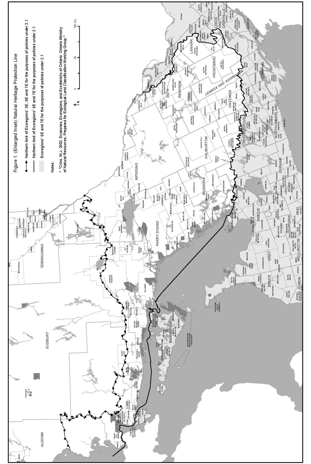
40 34
Provincial. Statement
 Provincial Statement This publication was produced by the Ministry of Municipal Affairs and Housing. For more copies of this document, in either English or French, please contact: Publications Ontario
Provincial Policy Statement 2014 Training Aid
 This job aid has been developed for education and training purposes as a high-level summary of the policy changes in the PPS 2014. It should not be relied upon as a substitute for specialized legal or
Provincial Policy Statement 2014
 Provincial Policy Statement 2014 Planning for Prosperity and Sustainability Intersecting Challenges Integrated Solutions The Provincial Policy Statement (PPS) sets out Ontario s land use planning directions
Provincial Policy Statement 2014
 Natural Heritage Provincial Policy Statement 2014 NATURAL HERITAGE Nature is bountiful. It is also fragile and finite. Provincial Natural Heritage 0 Interest: Ontario s natural heritage resources are valuable
PROVINCIAL POLICY STATEMENT RELATION TO THE PROVINCIAL PLAN
 COUNTY OF LAMBTON OFFICIAL PLAN UPDATE BACKGROUND REPORT NO. 1 PROVINCIAL POLICY STATEMENT RELATION TO THE PROVINCIAL PLAN Image Source: (Word Clip Art Stock Photos, 2011) Date: May, 2015 BACKGROUND PLANNING
RURAL RESIDENTIAL COMMUNITY ROLE COUNCIL ROLE RURAL RESIDENTIAL ALL COMMUNITIES
 Orderly and Efficient Land Use Align land use, development patterns, and infrastructure to make the best use of public and private investment. Discourage future development of rural residential patterns
LAND USE POLICIES BY COMMUNITY DESIGNATION
 137 2040 138 Land Use Policies by Community Designation As discussed earlier in Thrive MSP 2040, the Council assigns a community designation to each city and township. This designation indicates the overall
5-2 A Strong and Diverse Economy
 5-2 A Strong and Diverse Economy A STRONG AND DIVERSE ECONOMY 5.0 CONTENTS 5.1 EMPLOYMENT 5.1.1 General Policies 5.1.2 Protecting Employment Lands 5.1.3 Maintaining a Supply of Diverse Employment Lands
Planning Justification Report. 70 Pioneer Trail Fernbrook Homes (Parkside) Ltd. Official Plan Amendment Zoning By-law Amendment.
 Ltd. Official Plan Amendment Zoning By-law Amendment.") 70 Pioneer Trail Fernbrook Homes (Parkside) Ltd Planning Justification Report Official Plan Amendment Zoning By-law Amendment September 2016 The Jones Consulting Group Ltd. #1-229 Mapleview Drive East,
70 Pioneer Trail Fernbrook Homes (Parkside) Ltd Planning Justification Report Official Plan Amendment Zoning By-law Amendment September 2016 The Jones Consulting Group Ltd. #1-229 Mapleview Drive East,
COUNTY OF WELLINGTON Official Plan
 COUNTY OF WELLINGTON Official Plan OFFICE CONSOLIDATION This is an office consolidation of the which was adopted by Wellington County Council on September 24, 1998, approved by the Ministry of Municipal
LAND DEVELOPMENT AND PLANNING FORUM 2014 THE 2014 PROVINCIAL POLICY STATEMENT AND ENVIRONMENTAL PROTECTION
 LAND DEVELOPMENT AND PLANNING FORUM 2014 THE 2014 PROVINCIAL POLICY STATEMENT AND ENVIRONMENTAL PROTECTION MARY L. FLYNN-GUGLIETTI AND ANNIK FORRISTAL THE 2014 PROVINCIAL POLICY STATEMENT & ENVIRONMENTAL
URBAN CENTER COMMUNITY ROLE COUNCIL ROLE ALL COMMUNITIES URBAN CENTER
 Orderly and Efficient Land Use Align land use, development patterns, and infrastructure to make the best use of public and private investment. Plan for forecasted population and household growth at average
Ontario s Land Use Planning System
 Ontario s Land Use Planning System Economic Developers Council of Ontario February 2017 Marcia Wallace, PhD., MCIP, RPP Ministry of Municipal Affairs Our Work The Ministry of Municipal Affairs (MMA) is
Simcoe Area: A Strategic Vision for Growth
 Simcoe Area: A Strategic Vision for Growth June 2009 Table of Contents 1 Introduction 1 1.1 Purpose 1 1.2 Building Strong, Vibrant Communities 4 1.3 Managing Growth in the Simcoe Area 5 2 Guiding Principles
CITIZENS GUIDE THE PLANNING ACT MINISTRY OF MUNICIPAL AFFAIRS AND HOUSING
 THE PLANNING ACT 1 IN A SERIES Updated 2010 MINISTRY OF MUNICIPAL AFFAIRS AND HOUSING Introduction Land use planning affects almost every aspect of life in Ontario. It helps decide where in our communities
Airport Zoning Regulation to Protect Hospital Helicopter Flight Paths- Final Report. Planning and Growth Management Committee
 Revised PG24.3 STAFF REPORT ACTION REQUIRED Airport Zoning Regulation to Protect Hospital Helicopter Flight Paths- Final Report Date: October 18, 2017 To: From: Planning and Growth Management Committee
July State Planning Policy. Department of Infrastructure, Local Government and Planning
 July 2017 State Planning Policy Department of Infrastructure, Local Government and Planning The State of Queensland, July 2017. Published by the Department of Infrastructure, Local Government and Planning,
Section 32 Evaluation Report Business Mixed Use Zone (formerly the Business Zone) Contents
 Contents") Section 32 Evaluation Report Business Mixed Use Zone (formerly the Business Zone) Contents Section 32 Evaluation Report: Business Mixed Use Zone (formerly the Business Zone)... 2 1. Strategic Context...
Section 32 Evaluation Report Business Mixed Use Zone (formerly the Business Zone) Contents Section 32 Evaluation Report: Business Mixed Use Zone (formerly the Business Zone)... 2 1. Strategic Context...
Understanding the State Planning Policy July 2017 Changes to state interest statements, policies and assessment benchmarks
 Understanding the State Planning Policy July 2017 Changes to state statements, policies and assessment benchmarks This fact sheet outlines the key policy changes to the state statements, policies and assessment
SUBJECT: Draft New Official Plan: Public Consultation and Engagement Summary
 Page 1 of Report PB-47-17 SUBJECT: Draft New Official Plan: Public Consultation and Engagement Summary TO: FROM: Planning and Development Committee Planning and Building Department Report Number: PB-47-17
Niagara s Transportation Strategy 1. Introduction:
 Niagara s Transportation Strategy May 8, 2002 Niagara s Transportation Strategy 1. Introduction: Transportation is of pivotal importance in the development of Niagara. This, Niagara s first comprehensive
Managing Growth and Development
 Managing Growth and Development This technical document is part of a series of draft discussion papers created by Municipal Affairs staff and stakeholders to prepare for the Municipal Government Act Review.
THE REGION S PLAN POLICY FRAMEWORK. August 2015
 THE REGION S PLAN POLICY FRAMEWORK August 2015 2 What is The Policy Framework? Cover photo credit: Sinan Sinharoy for Atlanta BeltLine, Inc. Atlanta is one of the world s most dynamic metropolitan areas,
PLANNING FOR CHILDCARE IN THE GATEWAY DISTRICT NODE: CITY OF MISSISSAUGA
 APPENDIX F APPENDIX G APPENDIX H PROPOSED DRAFT AMENDMENT NO. TO THE OFFICIAL PLAN OF THE REGIONAL MUNICIPALITY OF PEEL 1.0 Statutory Provisions This Amendment No. to the Official Plan for
What we ve heard key issues
 Aug 10, 2016 Process to Date Update began early 2015 Information & engagement spring & summer 2015 August 5, 2015 open house (draft 1) October 5, 2015 release of draft 2 November 5, 2015 public meeting
- :~MM~Si6~ER:)ETc:...
ETc:...") AltMo,-_t This Is ExhIbit u"3 u, referred to In the Affidavit of M..r \(. t-\c.~ sworn beforeme this z» "" day of M,l '0'''\ - :~MM~Si6~ER:)ETc:... REGION OF PEEL REGIONAL OFFICIAL PLAN REGIONAL OFFICIAL
AltMo,-_t This Is ExhIbit u"3 u, referred to In the Affidavit of M..r \(. t-\c.~ sworn beforeme this z» "" day of M,l '0'''\ - :~MM~Si6~ER:)ETc:... REGION OF PEEL REGIONAL OFFICIAL PLAN REGIONAL OFFICIAL
PLANNING 2005 SERVICE STRATEGY BUSINESS PLAN
 TABLE OF CONTENTS A. Background A.1 Preparing the Service Strategy Business Plan... 1 A.2 Key Contacts... 1 A.3 Additional Information... 1 B. Description of Current Services B.1 Program Location Map...
Chapter 4: Transportation and Land Use
 Chapter 4: Transportation and Land Use Transportation and land use together make possible the wide range of destination opportunities in the region. Transportation provides the connections, and, in turn,
Your Bright Future: Municipal Development Plan
 Your Bright Future: Municipal Development Plan 2010-2020 Executive Summary OVERVIEW Municipalities face many challenges and opportunities. Central to a municipality s ability to provide a high standard
Draft Northwest Territories Conservation Areas Action Plan Frequently Asked Questions
 Draft Northwest Territories Conservation Areas Action Plan 2015-2020 Frequently Asked Questions 1. What is the draft Northwest Territories (NWT) Conservation Areas Action Plan 2015-2020? The draft Conservation
Draft Noise Abatement Guidelines
 Document under Separate Cover refer to IMLC01-13 Draft Noise Abatement Guidelines April 2013 Legislative & Planning Services Table of Contents 1.0 Introduction...1 1.1 Key Definitions...1 2.0 Existing
NORTHWEST TERRITORIES CONSOLIDATION OF CAPITAL AREA DEVELOPMENT SCHEME BY LAW NO. 3934
 NORTHWEST TERRITORIES CONSOLIDATION OF CAPITAL AREA DEVELOPMENT SCHEME BY LAW NO. 3934 Adopted December 16, 1996 AS AMENDED BY By law No. 4811 September 22, 2014 (This Consolidation is prepared for convenience
Town & Country Planning Act 1990
 Town & Country Planning Act 1990 Your Ref: 17/0411/OUT Proposed Development at Gwern y Domen by PMG Ltd and Persimmon Homes Ltd I of am against the proposed development for a number of reasons which are
CITIZENS GUIDE THE PLAN REVIEW AND APPROVAL PROCESS IN A SERIES MINISTRY OF MUNICIPAL AFFAIRS AND HOUSING
 THE PLAN REVIEW AND APPROVAL PROCESS 9 IN A SERIES Updated 2010 MINISTRY OF MUNICIPAL AFFAIRS AND HOUSING Introduction Land use planning affects almost every aspect of life in Ontario. It helps decide
GRAND NIAGARA Proposed Secondary Plan
 GRAND NIAGARA Proposed Secondary Plan Public Open House #3 January 17. 2017 scope + process BUILT Grand Niagara Secondary Plan The Grand Niagara Secondary Plan will establish a framework for the future
A THRIVING MIDDLE GEORGIA
 Plan for A THRIVING MIDDLE GEORGIA Regional Opportunities and Action Items Part I January 8, 2015 Update since December 16 Meetings in each of the 11 counties. Topics include: future development patterns
H2. Residential Rural and Coastal Settlement Zone
 H2. Residential Rural and Coastal Settlement Zone H2.1. Zone description The Residential Rural and Coastal Settlement Zone applies to rural and coastal settlements in a variety of environments including
407 TRANSITWAY. Planning & Preliminary Design
 FROM EAST OF HIGHWAY 400 TO KENNEDY ROAD GWP #252-96-00 Public Information Centre #2 June 24 th and 29 th, 2010 Purpose of Public Information Centre #2 The first Public Information Centre (PIC #1) was
OFFICIAL PLAN FOR THE MUNICIPALITY OF MAGNETAWAN
 OFFICIAL PLAN FOR THE MUNICIPALITY OF MAGNETAWAN Prepared by July 24, 2002 May 16, 2005 and June 14, 2005 With Jim s Notes on Modifications Modifications provided by MMAH on May 10, 2005 and June 8, 2005
Results-based Plan Briefing Book
 Results-based Plan Briefing Book 2014-15 Ministry of Municipal Affairs and Housing ISSN# 1718-6854 Ce document est disponible en français Ministry of Municipal Affairs and Housing TABLE OF CONTENTS PART
City of Brantford Chapter 3 TABLE OF CONTENTS
 Chapter 3 The Land Use & Transportation Connection TABLE OF CONTENTS 3.1 THE LAND USE & TRANSPORTATION LINK... 1 3.2 POPULATION & EMPLOYMENT GROWTH FORECASTS... 3 3.2.1 Proposed Places to Grow Plan Forecasts
CITIZENS GUIDE OFFICIAL PLANS MINISTRY OF MUNICIPAL AFFAIRS AND HOUSING
 OFFICIAL PLANS 2 IN A SERIES S Updated 2010 MINISTRY OF MUNICIPAL AFFAIRS AND HOUSING Introduction Land use planning affects almost every aspect of life in Ontario. It helps decide where in our communities
EVOLUTION OF NIAGARA ESCARPMENT GOVERNANCE
 EVOLUTION OF NIAGARA ESCARPMENT GOVERNANCE Graham Whitelaw 1 and James Hamilton 2 1 School of Planning, Faculty of Environmental Studies, University of Waterloo, Waterloo, Ontario, N2L 3G1. Email:grahamwhitelaw@thegreenpages.ca
AND. Principal Environment Judge L J Newhook sitting alone under s 279 of the Act In Chambers at Auckland CONSENT ORDER
 BEFORE THE ENVIRONMENT COURT IN THE MATTER of the Resource Management Act 1991 (the Act) and the Local Government (Auckland Transitional Provisions) Act 2010 (LGATPA) AND IN THE MATTER of an appeal under
- FACT SHEET - THE GUIDING PRINCIPLES
 THE GUIDING PRINCIPLES The General Plan begins with seven ideas that together create a vision for the City s future. When the City approved the General Plan in 1994, these idea were dubbed the Seven Guiding
Waterfront and Rural Background Policy Paper
 Waterfront and Rural Background Policy Paper Executive Summary In support of the preparation of the City s new Official Plan, this background report provides a review of the existing policy context for
RURAL LIVING AREAS Rural Living Areas Rural Lifestyle and Rural Residential 8.1 Issues, Objectives and Policies
 . Rural Living Areas Rural Lifestyle and Rural Residential.1 Issues, Objectives and Policies.1.1 Resource Management Issues Discussion of additional relevant issues is found in the following Parts of the
Introduction Page I-1 INTRODUCTION
 Introduction Page I-1 INTRODUCTION The Arcata General Plan: 2020 will help shape how the city of Arcata will look, function, provide services, and manage resources for the next 20 years. The plan is the
Other Concepts. Physical Development and Form
 Other Concepts Physical Development and Form Relationship of Concepts to Public Health: Complete communities that display compact urban form and mixed-used development are key to optimizing the potential
Working with Transportation Concurrency Exception Areas
 Working with Transportation Concurrency Exception Areas September 2006 Presented by the Florida Department of Transportation Working with Transportation Concurrency Exception Areas Volume 1, September
6.0 Indirect Effects and Cumulative Impacts
 6.0 Effects and Impacts 6.1 Introduction This chapter of the Draft EIS addresses potential indirect and cumulative impacts of the Bottineau Transitway project. effects are those that are caused by the
Babergh & Mid Suffolk Joint Local Plan: Sustainability Appraisal. August 2017
 Babergh & Mid Suffolk Joint Local Plan: Sustainability Appraisal August 2017 Contents NON TECHNICAL SUMMARY... 1 CHAPTER 1 INTRODUCTION... 2 Table 1: Stages of SA/SEA production... 2 Table 2: Statutory
Rural Living Environment
 1 RLE.1 Rural Living Environment RLE.1.1 Description & Expectations The Rural Living Environment (RLE) covers rural areas within the District that are either already characterised by lifestyle activities
TREASURE COAST REGIONAL PLANNING COUNCIL M E M O R A N D U M. To: Council Members AGENDA ITEM 3E
 TREASURE COAST REGIONAL PLANNING COUNCIL M E M O R A N D U M To: Council Members AGENDA ITEM 3E From: Date: Subject: Staff May 19, 2017 Council Meeting Local Government Comprehensive Plan Review Draft
British Columbia s. VVater Act. Modernization. Policy Proposal on British Columbia s new Water Sustainability Act. December 2010
 British Columbia s VVater Act Modernization Policy Proposal on British Columbia s new Water Sustainability Act December 2010 British Columbia has a rich heritage in our lakes, rivers and streams. Linked
III. King County Guiding Principles
 III. King County Guiding Principles 2016 Comprehensive Plan December 5, 2016 The Comprehensive Plan is based on the principles of creating sustainable neighborhoods, preserving open space, farmland, and
Section 9 Implementation
 Section 9 Implementation 9 Section 9: Implementation 9.1 Overview The primary role of Your Bright Future is to provide a community sustainability based framework to direct the future growth and development
SOUTHEAST FLORIDA REGIONAL COMPACT CLIMATE CHANGE. Sustainable Communities & Transportation Planning
 SOUTHEAST FLORIDA REGIONAL COMPACT CLIMATE CHANGE Draft Regional Climate Action Plan Sustainable Communities & Transportation Planning SP-1 Develop criteria in collaboration with municipal and county planning
Getting Municipalities to Work, or Getting Work to Municipalities: Protection and Conversion of Employment Lands
 Getting Municipalities to Work, or Getting Work to Municipalities: Protection and Conversion of Employment Lands Barnet Kussner Partner WeirFoulds LLP bkussner@weirfoulds.com Introduction Over the course
Report for Agenda Item: 2
 QLDC Council 28 September 2017 Department: Planning & Development Report for Agenda Item: 2 Stage 2 Proposed District Plan Notification Purpose The purpose of this paper is to present those parts of Stage
Natural Systems Planning Primer
 Natural Systems Planning Primer Lise.Guevremont@ottawa.ca Amy.Macpherson@ottawa.ca Land Use and Natural Systems Unit Planning and Growth Management November 2015 1 Welcome Policy Framework Development
1 RICHMOND HILL CENTRE / LANGSTAFF URBAN GROWTH CENTRE - TRANSPORTATION STUDY
 Report No. 4 of the Transportation Services Committee Regional Council Meeting of April 22, 2010 1 RICHMOND HILL CENTRE / LANGSTAFF URBAN GROWTH CENTRE - TRANSPORTATION STUDY The Transportation Services
BUT001: Land to the east of Benington Road, Butterwick Sustainability Objective
 BUT001: Land to the east of Benington Road, Butterwick Sustainability Objective 1. Provide a miture of sustainably designed new housing to provide everybody in South East Lincolnshire with the opportunity
GOOD NEIGHBOR POLICY
 Regional Open Space MIDPENINSULA REGIONAL OPEN SPACE DISTRICT GOOD NEIGHBOR POLICY Adopted by the Board of Directors October 26, 1988 Amended August 14, 1996 Amended September 26, 2007 Introduction The
City of Kitchener. Telecommunication Tower and Antenna Protocol. October 1, Table of Contents. Site Selection Design & Landscaping
 - - 1 - - City of Kitchener Telecommunication Tower and Antenna Protocol October 1, 2010 Table of Contents Section 1 Section 2 Section 3 Section 4 Section 5 Section 6 Section 7 Introduction and Objectives
Sustainability. Sustainability Principles. 1. Framework. Spokane Transit s definition of Sustainability is:
 Sustainability Spokane Transit s definition of Sustainability is: Sustainability at Spokane Transit is about providing services in ways that optimize our ability to meet the needs of present and future
BYLAW NO LEDUC COUNTY
 BYLAW NO. 27-14 LEDUC COUNTY A BYLAW OF LEDUC COUNTY, IN THE PROVINCE OF ALBERTA, TO AMEND THE CITY OF LEDUC/LEDUC COUNTY INTERMUNICIPAL DEVELOPMENT PLAN BYLAW 30-11. WHEREAS The Council of Leduc County
EXECUTIVE OFFICE OF THE GOVERNOR
 EXECUTIVE OFFICE OF THE GOVERNOR STATE REPORT OF FINDINGS AND RECOMMENDATIONS FOR THE TREASURE COAST REGIONAL PLANNING COUNCIL'S STRATEGIC REGIONAL POLICY PLAN OCTOBER 23, 1995 INTRODUCTION The State Report
H3. Residential Single House Zone
 H3. Residential Single House Zone H3.1. Zone description The purpose of the Residential Single House Zone is to maintain and enhance the amenity values of established residential neighbourhoods in number
Chapter 3 - Goals, Objectives, & Strategies
 Chapter 3 - This chapter presents goals, objectives, and strategies that have been developed as part of the Richmond Area MPO 2026 Long-Range Transportation Plan (LRTP) update. Strategies have been developed
Action Plan for a New Local Governance System in New Brunswick
 Action Plan for a New Local Governance System in New Brunswick December 2011 A message from the Premier As part of our 2010 election platform, Putting New Brunswick First, our Government committed to forging
LUNDY S LANE COMMUNITY IMPROVEMENT PLAN STUDY
 PUBLIC INFORMATION MEETING # October, 0 LUNDY S LANE COMMUNITY IMPROVEMENT PLAN STUDY AGENDA :00 to :0pm: Open House :0 to :pm: Presentation : to :00pm: Individual paced workshop with the Study Team PUBLIC
IX. STRATEGIC PLAN ELEMENT
 IX. STRATEGIC PLAN ELEMENT The Strategic Plan Element provides the action and implementation plan for the New Brunswick Master Plan. New Brunswick is a fully developed, older urban area in central New
FERRY COUNTY COUNTY-WIDE PLANNING POLICIES
 FERRY COUNTY COUNTY-WIDE PLANNING POLICIES This memorandum of understanding lays out the framework upon which the comprehensive planning process for Ferry County and the City of Republic will be built.
Guelph Innovation District
 Guelph Innovation District Community Meeting, June 18, 2009 1 Welcome Meeting Purpose: Present City & Provincial work that is completed or underway Discuss how recent initiatives/studies will influence
Transportation BUSINESS PLAN ACCOUNTABILITY STATEMENT
 Transportation BUSINESS PLAN 2003-06 ACCOUNTABILITY STATEMENT The for the three years commencing April 1, 2003 was prepared under my direction in accordance with the Government Accountability Act and the
Bill 36, the Alberta Land Stewardship Act sets the bar for responsible regional planning
 April 27, 2009 Bill 36, the Alberta Land Stewardship Act sets the bar for responsible regional planning Proposed Act respects property rights and local decision-making Edmonton... Future development in
Plan Edmonton: Edmonton s Municipal Development Plan
 Plan Edmonton: Edmonton s Municipal Development Plan Schedule A of Bylaw No. 11777 Approved August 31, 1998, with Amendments to January 22, 2007 The City Council of the City of Edmonton will amend Plan
1.1.1.b. Agencies share best practices as they integrate COMPASS facilitates
 Transportation Goals 1.1 Enhance the system to improve accessibility and connectivity to jobs, schools, and services; allow the efficient movement of people and goods; and ensure the reliability of travel
DRAFT SWOT Findings. Economic Vision for the City of Burlington. Burlington Economic Development Corporation. June 18, 2015
 DRAFT SWOT Findings Economic Vision for the City of Burlington Burlington Economic Development Corporation June 18, 2015 1 Millier Dickinson Blais: BEDC Burlington Economic Vision, Draft SWOT Findings
Special Areas and Improvement Districts
 Special Areas and Improvement Districts This technical document is part of a series of draft discussion papers created by Municipal Affairs staff and stakeholders to prepare for the Municipal Government
18 Cumulative Impacts and Interaction of Effects
 18 Cumulative Impacts and Interaction of Effects 18.1 Introduction This chapter addresses the cumulative impacts and main interactions between different aspects of the environment likely to be significantly
Township of Cavan Monaghan. Zoning By-law Project. Review and Update. Discussion Paper 7. Agricultural and Rural Areas
 Township of Cavan Monaghan Zoning By-law Project Review and Update Discussion Paper 7 Agricultural and Rural Areas Draft May 2017 Table of Contents Forward... 2 Executive Summary... 5 1.0 Official Plan
3. STATION SPACING AND SITING GUIDELINES
 3. STATION SPACING AND SITING GUIDELINES The station spacing and siting guidelines are summarized in Table 3-1. Table 3-1 also includes benchmark information for local transit service and express bus as
YAKIMA COUNTY-WIDE PLANNING POLICY
 YAKIMA COUNTY-WIDE PLANNING POLICY A Policy Framework to Guide the Development of Comprehensive Plans Under the Washington State Growth Management Act Originally adopted June 1993 Revised and adopted October
Bill Proposed Amendments to the Planning Act and the Province s Land Use Planning Appeal System
 PG23.7 REPORT FOR ACTION Bill 139 - Proposed Amendments to the Planning Act and the Province s Land Use Planning Appeal System Date: September 29, 2017 To: Planning and Growth Management Committee From:
An outline of the Basic Conditions governing our Plan
 An outline of the Basic Conditions governing our Plan Introduction What follows is a distillation of current central & local government policies that have a bearing on our plan. They may not make exciting
TRANSPORTATION MOBILITY PLAN GUIDELINES
 TRANSPORTATION MOBILITY PLAN GUIDELINES for Development Applications November 2016 Executive Summary The Regional Municipality of York (the Region) is located in the heart of the Greater Toronto Area (GTA)
AUMA Policy Paper 2013.A1
 AUMA Paper 2013.A1 AUMA Board of Directors Municipal Water on Wetlands WHEREAS in 2012 the AUMA Board of Directors issued the mandate of developing Municipal Water Policies and approved advancing polices
Introduction. Comprehensive Plan
 Comprehensive Plan 2010-2030 1 The City of Elwood Comprehensive Plan establishes a development strategy and policies to guide the future growth and development of the community for the next two decades.
Aggregate Industry Discussion Paper
 : The Aggregate Industry Discussion Paper April 30, 2015 Overview Recommendations 1. The public and provincial interest in close to market aggregate supply can only be achieved if Provincial Plans contain
H3 Residential Single House Zone
 H3. Residential Single House Zone [ENV-2016-AKL-000243: K Vernon] Addition sought [CIV-2016-404-002333: Franco Belgiorno-Nettis]-Note: The properties affected by this appeal are identified on the Auckland
CITIZENS GUIDE LAND SEVERANCES MINISTRY OF MUNICIPAL AFFAIRS AND HOUSING
 LAND SEVERANCES 5 IN A SERIES Updated 2010 MINISTRY OF MUNICIPAL AFFAIRS AND HOUSING Introduction Land use planning affects almost every aspect of life in Ontario. It helps decide where in our communities
Sustainable Natural Environment Fish Habitat
 Town of Huntsville Official Plan Review - POLICY BACKGROUND PAPER Sustainable Natural Environment Fish Habitat BACKGROUND: Lakes, rivers, streams, ponds and many wetlands provide fish habitat. Intermittent
To provide an update on the progress of the Peel Goods Movement Task Force and the Peel Goods Movement Strategic Plan.
 9.2-1 REPORT Meeting Date: 2015-11-26 Regional Council For Information DATE: November 10, 2015 REPORT TITLE: REGION OF PEEL GOODS MOVEMENT STRATEGIC PLAN - 2015 STATUS UPDATE FROM: Dan Labrecque, Commissioner
City of Edmonton Zoning Bylaw Parking Study Final Report
 City of Edmonton Zoning Bylaw Parking Study Prepared For: City of Edmonton Date: March 26, 2010 Prepared By: Bunt & Associates Project No.: 3027.24 TABLE OF CONTENTS SECTION TITLE PAGE NO. Acknowledgements
Statutory Changes to the Community Planning Act (Chapter 163, Part II, Florida Statutes):
:") Contents 1986: Chapter 86 191, sections 7 12 and 18 31, Laws of Florida... 3 1987 Chapter 87 224, sections 24, 25 and 26 (Reviser s bill) and Chapter 87 338, Laws of Florida... 4 1988, 1989, and 1990 [None]...
Contents 1986: Chapter 86 191, sections 7 12 and 18 31, Laws of Florida... 3 1987 Chapter 87 224, sections 24, 25 and 26 (Reviser s bill) and Chapter 87 338, Laws of Florida... 4 1988, 1989, and 1990 [None]...
Purpose of the Countywide Transportation Plan SAN FRANCISCO COUNTY TRANSPORTATION AUTHORITY
 > 12 Purpose of the Countywide Transportation Plan SAN FRANCISCO COUNTY TRANSPORTATION AUTHORITY 13 SAN FRANCISCO S MULTIMODAL transportation network is crucial to San Francisco s status as a major regional
A Better Life in Rural Areas
 A Better Life in Rural Areas Considerations Having met at Cork, Ireland from 5 th to 6 th September 2016 Building Considering on the 1996 Cork Declaration "A living countryside"- developed by the participants
OF CONTENTS 14.0 COUNTY OF BRANT...
 TABLE OF CONTENTS 14.0 COUNTY OF BRANT... 14-1 14.1 Definitions... 14-1 14.2 County Of Brant Source Protection Plan Policies... 14-2 14.3 Policies Addressing Prescribed Drinking Water Threats... 14-6 14.4