Shingle Creek And West Mississippi. Watershed Management Commissions
|
|
|
- Kathryn Lynch
- 6 years ago
- Views:
Transcription
1 Shingle Creek And West Mississippi Watershed Management Commissions Rules and Standards April 2013 Revisions Effective April 11, 2013 Amended July 11, 2013
2 SHINGLE CREEK/WEST MISSISSIPPI WATERSHED MANAGEMENT COMMISSIONS RULES AND STANDARDS Policy Statement... 3 Relationship with Municipalities and County... 3 A. Definitions... 4 B. Procedural Requirements... 8 C. General Standards D. Stormwater Management E. Erosion and Sediment Control F. Floodplain Alteration G. Wetland Alteration H. Bridge and Culvert Crossings I. Buffer Strips J. Fees K. Variances L. Enforcement M. Amendment Appendix A Wet Pond Design Standards
3 POLICY STATEMENT The Shingle Creek and West Mississippi Watershed Management Commissions are Joint Powers Associations of the State under the Minnesota Watershed Act, and watershed management organizations as defined in the Metropolitan Surface Water Management Act. These acts provide the Commissions with power to accomplish their statutory purpose: the conservation, protection, and management of water resources in the boundaries of the watersheds through sound scientific principles. The Commissions have adopted a water resources management plan pursuant to the Acts. These Rules implement the plan s principles and objectives. Land alteration and utilization can affect the rate and volume and degrade the quality of surface water runoff within the watersheds. Sedimentation from ongoing erosion and construction activities will reduce hydraulic capacity of waterbodies and degrade water quality. Water quality problems already exist in many waterbodies in the watershed. Several of the waterbodies have been designated by the State of Minnesota as Impaired Waters, and do not meet state water quality standards. Activities that increase the rate or volume of stormwater runoff will aggravate existing flooding problems and contribute to new ones. Activities that degrade runoff quality will cause quality problems in receiving water. Activities that fill floodplain or wetland areas will reduce flood storage and hydraulic capacity of waterbodies, and will degrade water quality by eliminating the filtering capacity of such areas. These Rules and Standards protect the public health, welfare, and natural resources of the watershed by regulating the improvement or alteration of land and waters in the watershed to 1) reduce the severity and frequency of high water, 2) preserve floodplain and wetland storage capacity, 3) improve the chemical and physical quality of surface waters, 4) reduce sedimentation, 5) preserve the hydraulic and navigational capacities of waterbodies, 6) promote and preserve natural infiltration areas, and 7) preserve natural shoreline features. In addition to protecting natural resources, these Rules and Standards are intended to minimize future public expenditures on problems caused by the improvement or land and water alterations. RELATIONSHIP WITH MUNICIPALITIES AND COUNTY The Commissions recognize that the control and determination of appropriate land use is the responsibility of the municipalities and the county. The Commissions will review projects involving land-disturbing activities as requested by the local municipalities. The Commissions intend to be active in the regulatory process to ensure that water resources are managed in accordance with its goals and policies. The Commissions will require a project review for developments and improvements in the watershed that meet the thresholds specified in the Rules. 1 P a g e A p r i l 2013
4 The Commissions desire to provide technical advice to the municipalities in the preparation of local stormwater management plans and the review of projects that may affect water resources prior to investment of significant public or private funds. RULE A - DEFINITIONS For the purposes of these Rules, unless the context otherwise requires, the following words and terms shall have the meanings set forth below. References in these Rules to specific sections of the Minnesota Statutes or Rules include amendments, revisions or recodifications of such sections. The words shall and must are mandatory; the word may is permissive. Abstraction. Removal of stormwater from runoff, by such methods as infiltration, evaporation, transpiration by vegetation, and capture and reuse, such as capturing runoff for use as irrigation water. Agricultural Activity. The use of land for the production of agronomic, horticultural or silvicultural crops, including nursery stock, sod, fruits, vegetables, flowers, cover crops, grains, Christmas trees, and grazing. Alteration or Alter. When used in connection with public waters or wetlands, any activity that will change or diminish the course, current, or cross-section of public waters or wetlands. Applicant. Any person or political subdivision that submits an application to the Commissions for a project review under these Rules. Best Management Practices (BMPs). Techniques proven to be effective in controlling runoff, erosion and sedimentation including those documented in the Minnesota Construction Site Erosion and Sediment Control Planning Handbook (BWSR 1988), Protecting Water Quality in Urban Areas (MPCA 2000), and the Minnesota Stormwater Manual (MPCA 2005) as revised. Biofiltration. Using living material to capture and/or biologically degrade or process pollutants prior to discharging stormwater, such as directing runoff through a vegetated buffer or to a rain garden or vegetated basin with an underdrain. Bioretention. A terrestrial-based (upland, as opposed to wetland) water quality and water quantity control process. Bioretention employs a simplistic, site-integrated design that provides opportunity for runoff infiltration, filtration, storage and water uptake by vegetation. Buffer Strip. An area of natural, unmaintained, vegetated ground cover abutting or surrounding a watercourse or wetland. BWSR. The Minnesota Board of Water and Soil Resources. Commission. The Shingle Creek or West Mississippi Watershed Management Commission, as applicable. 2 P a g e A p r i l 2013
5 Commissioners. The Board of Commissioners of the Shingle Creek or West Mississippi Watershed Management Commissions. Compensatory Storage. Excavated volume of material below the floodplain elevation required to offset floodplain fill. County. Hennepin County, Minnesota. Dead Storage. The permanent pool volume of a water basin or the volume below the runout elevation of a water basin. Detention Basin. Any natural or manmade depression for the temporary storage of runoff. Development. The construction of any structure on or the subdivision of land. Drain or Drainage. Any method for removing or diverting water from waterbodies, including excavation of an open ditch, installation of subsurface drainage tile, filling, diking, or pumping. Erosion. The wearing away of the ground surface as a result of wind, flowing water, ice movement, or land disturbing activities. Erosion and Sediment Control Plan. A plan of BMPs or equivalent measures designed to control runoff and erosion and to retain or control sediment on land during the period of land disturbing activities in accordance with the standards set forth in these Rules. Excavation. The artificial removal of soil or other earth material. Fill. The deposit of soil or other material by artificial means. Filtration. A process by which stormwater runoff is captured, temporarily stored, and routed through a filter bed to improve water quality and slow down stormwater runoff. Floodplain. The area adjacent to a waterbody that is inundated during a 100-year flood. HCD. The Hennepin Conservation District. Impaired Water. A waterbody that does not meet state water quality standards and that has been included on the MPCA Section 303(d) list of Impaired Waters of the state. Impervious Surface. A surface compacted or covered with material so as to be highly resistant to infiltration by runoff. Impervious surface shall include roads, driveways and parking areas, whether or not paved, sidewalks greater than 3 feet wide, patios, tennis and basketball courts, swimming pools, covered decks and other structures. Open decks with joints at least ¼ inch 3 P a g e A p r i l 2013
6 wide, areas beneath overhangs less than 2 feet wide, and sidewalks 3 feet or less wide shall not constitute impervious surfaces under these Rules. Infiltration. The passage of water into the ground through the soil. Infiltration Area. Natural or constructed depression located in permeable soils that capture, store and infiltrate the volume of stormwater runoff associated with a particular design event. Interested Party. A person or political subdivision with an interest in the pending subject matter. Land Disturbing Activity. Any change of the land surface to include removing vegetative cover, excavation, fill, grading, and the construction of any structure that may cause or contribute to erosion or the movement of sediment into waterbodies. The use of land for agricultural activities shall not constitute a land disturbing activity under these Rules. Landlocked Basin. A basin that is 1 acre or more in size and does not have a natural outlet at or below the 100-year flood elevation as determined by the 100-year, 10-day runoff event. Low Floor. The finished surface of the lowest floor of a structure. Member City. Any city wholly or partly within the Commission s boundary that has executed the Joint Powers Agreement. MnDOT. The Minnesota Department of Transportation. MPCA. The Minnesota Pollution Control Agency. Municipality. Any city wholly or partly within the Commission s boundary. NPDES. National Pollutant Discharge Elimination System. NRCS. The Natural Resource Conservation Service. NURP. The Nationwide Urban Runoff Program developed by the Environmental Protection Agency to study stormwater runoff from urban development. Ordinary High Water Level (OHW). The boundary of waterbodies and shall be an elevation delineating the highest water level which has been maintained for a sufficient period of time to leave evidence upon the landscape, commonly that point where the natural vegetation changes from predominantly aquatic to predominantly terrestrial. For watercourses, the OHW level is the elevation of the top of the bank of the channel. For reservoirs and flowages, the OHW level is the operating elevation of the normal summer pool. Owner. The owner of a parcel of land or the purchaser under a contract for deed. 4 P a g e A p r i l 2013
7 Parcel. A parcel of land designated by plat, metes, and bounds, registered land survey, auditor s subdivision, or other accepted means and separated from other parcels or portions by its designation. Person. Any individual, trustee, partnership, unincorporated association, limited liability company or corporation. Political Subdivision. A municipality, county or other political division, agency or subdivision of the state. Project. A space, parcel, or parcels of real property owned by one or more than one person which is being or is capable of being developed or redeveloped as a single project. Public Health and General Welfare. Subdivisions 23 and 24. Defined in Minnesota Statutes, Section 103D.011, Public Waters. Any waters as defined in Minnesota Statutes, Section 103G.005, Subdivision 15. Public Waters Wetland. Any wetland as defined in Minnesota Statutes, Section 103G.005, Subdivision 15a. Redevelopment. The rebuilding, repair, or alteration of a structure, land surface, or facility for which over 50% of the parcel involved is disturbed by a land-disturbing activity. Runoff. Rainfall, snowmelt or irrigation water flowing over the ground surface. Sediment. Soil or other surficial material transported by surface water as a product of erosion. Sedimentation. The process or action of depositing sediment. Shoreland Protection Zone. Land located within a floodplain or within 1,000 feet of the OHW of a public water or public waters wetland. Site. A space, parcel, or parcels of real property owned by one or more than one person which is being or is capable of being developed or redeveloped as a single project. Standard. A required level of quantity, quality, or value. Stormwater Management Plan. A plan for the permanent management and control of runoff prepared and implemented in accordance with the standards set forth in these Rules. Structure. Anything manufactured, constructed or erected which is normally attached to or positioned on land, including portable structures, earthen structures, roads, water and storage systems, drainage facilities and parking lots. 5 P a g e A p r i l 2013
8 Subdivision or Subdivide. The separation of a parcel of land into two or more parcels. TMDL. The Total Maximum Daily Load is the maximum amount of a pollutant that a waterbody can receive and still meet water quality standards. TMDL can also refer to a study that calculates that load, or to the allocation of that allowable load to its various sources. An Implementation Plan may be part of the TMDL study or it may be a separate document that sets forth the steps that will be taken to achieve the TMDL. Volume Management. The retention and abstraction of a certain volume of stormwater runoff onsite through techniques such as infiltration, evapotranspiration, and capture and reuse. Water Basin. An enclosed natural depression with definable banks capable of containing water that may be partly filled with public waters. Waterbody. All water basins, watercourses and wetlands as defined in these Rules. Watercourse. Any natural or improved stream, river, creek, ditch, channel, culvert, drain, gully, swale, or wash in which waters flow continuously or intermittently in a definite direction. Water Resources Management Plan. The watershed management plan for the Commission adopted and implemented in accordance with Minnesota Statutes, Section 103B.231. Watershed. Region draining to a specific watercourse or water basin. Wetland. Land transitional between terrestrial and aquatic systems as defined in Minnesota Statutes, Section 103G.005, Subdivision 19. Wetland Conservation Act (WCA). Minnesota Wetland Conservation Act of 1991 as amended. RULE B - PROCEDURAL REQUIREMENTS 1. APPLICATION REQUIRED. Any person, or political subdivision, undertaking an activity for which a project review is required by these Rules shall first submit to the applicable Commission a project review application, design data, plans, specifications, fees, and such other information and exhibits as may be required by these Rules. Project review applications shall be signed by the owner, or the owner s authorized agent, except for activities of a political subdivision which may be signed by either the owner or the general contractor. All project review applications must be authorized by the municipality where the proposed project is located. 2. FORMS. Project review applications shall be submitted on forms provided by the Commission. Forms are available at the Commission office or Internet Web site. 6 P a g e A p r i l 2013
9 3. ACTION BY COMMISSION. The Commission shall act within 60 days after receipt of a complete application, including all required information, exhibits and fees. If a state or federal law or court order requires a process to occur before the Commission acts on an application, or if an application requires prior approval of a state or federal agency, the deadline for the Commission to act is extended to 60 days after completion of the required process or the required prior approval is granted. The Commission may extend the initial 60-day period by providing written notice of the extension to the applicant. The extension may not exceed 60 days unless approved by the applicant. 4. SUBMITTAL. A complete project review application with all required information and exhibits shall be filed with the Commission at least 14 calendar days prior to the scheduled meeting date of the Commission. Late or incomplete submittals will be scheduled to a subsequent meeting date. 5. NOTIFICATION. The Commission shall mail notice of the project review application to the owners of land located adjacent to the described activity, adjacent defined as located within the radius for which notice is required by the member city for review by its Planning Commission of site plan submittals, to a maximum of 300 feet (or 300 feet if the municipality does not require mailed notice of plan reviews), and to the member city or county with jurisdiction over the activity, at least 7 days prior to the scheduled meeting date of the Commission at which the application will be considered. The names and addresses of the owners to be notified shall be obtained by the applicant from the Hennepin County Office of Taxpayer Services and furnished to the Commission on mailing labels or electronic file with the project review application. The project review application will not be processed until the list of owners has been submitted. Notice may be waived by the member city if such a notification has been made as a part of the Planning Commission review process. Neither the failure to give mailed notice to any owner nor any defect in the notice shall invalidate an action by the Commission on a project review application. 6. CONDITIONS. A project review may be approved subject to reasonable conditions to assure compliance with these Rules. The conditions may include a requirement that the applicant and owner enter into an agreement with the member city in a form acceptable to the Commission to a) specify responsibility for the construction and future maintenance of approved structures or facilities, b) document other continuing obligations of the applicant or owner, c) grant reasonable access to the proper authorities for inspection, monitoring and enforcement purposes, d) affirm that the Commission or other political subdivisions can require or perform necessary repairs or reconstruction of such structures or facilities, e) require indemnification of the Commission for claims arising from issuance of the approved project review or construction and use of the approved structures or facilities, and f) reimburse the reasonable costs incurred to enforce the agreement. Project reviews and agreements may be filed for record to provide notice of the conditions and continuing obligations. 7 P a g e A p r i l 2013
10 7. ISSUANCE OF PROJECT REVIEWS. The Commission will issue a project review approval only after the applicant has satisfied all requirements of these Rules and paid all required fees. 8. VALIDITY. Issuance of a project review approval based on plans, specifications, or other data shall not prevent the Commission from thereafter requiring the correction of errors in the approved plans, specifications and data, or from preventing any activity being carried on thereunder in violation of these Rules. 9. MODIFICATIONS. The applicant shall not modify the approved activity or plans and specifications on file with the Commission without the prior approval of the Commission. 10. INSPECTION AND MONITORING. After issuance of a project review approval, the Commission may perform such field inspections and monitoring of the approved activity as the Commission deems necessary to determine compliance with the conditions of the project review and these Rules. Any portion of the activity not in compliance shall be promptly corrected. In applying for a project review, the applicant consents to entry upon the land for field inspections and monitoring, or for performing any work necessary to bring the activity into compliance. 11. SUSPENSION OR REVOCATION. The Commission may suspend or revoke an approved project review issued under these Rules whenever the project review approval is issued in error or on the basis of incorrect information supplied, or in violation of any provision of these Rules, or if the preliminary and final project approvals received from the municipality or county are not consistent with the conditions of the approved project review. 12. REGULAR MEETINGS. Regular meetings of the Commission are held on the second Thursday of each month at 12:45 p.m., unless notice of a different date or time is given. 13. SEVERABILITY. If any provision of these Rules is adjudged unconstitutional or invalid by a court of competent jurisdiction, the remainder of these Rules shall not be affected thereby. RULE C - GENERAL STANDARDS 1. POLICY. It is the policy of the Commission to protect the water resources of the watershed by requiring that all activities within the watershed comply with minimum standards for the protection of water quality and the environment. 2. REGULATION. (a) All land disturbing activities, whether requiring a project review under these Rules or otherwise, shall be undertaken in conformance with BMPs and in compliance with the standards and criteria in these Rules. 8 P a g e A p r i l 2013
11 (b) Project reviews are required of any land disturbing activity meeting the review thresholds set forth in Rule D Section 2. (c) In areas that drain to Impaired Waters, TMDL Implementation Plans may include sitespecific requirements for any land-disturbing activities that are in addition to these rules and standards. (d) No person shall conduct land-disturbing activities without protecting adjacent property and waterbodies from erosion, sedimentation, flooding, or other damage. (e) Development shall be planned and conducted to minimize the extent of disturbed area, runoff velocities, and erosion potential, and to reduce and delay runoff volumes. Disturbed areas shall be stabilized and protected as soon as possible and facilities or methods used to retain sediment on-site. (f) When possible, existing natural watercourses and vegetated soil surfaces shall be used to convey, store, filter, and retain runoff before discharge into public waters or a stormwater conveyance system. (g) When possible, runoff from roof gutter systems shall discharge onto lawns or other pervious surfaces to promote infiltration. (h) Use of fertilizers and pesticides in the shoreland protection zone shall be so done as to minimize runoff into public waters by the use of earth material, vegetation, or both. No phosphorus fertilizer shall be used unless a soil nutrient analysis shows a need for phosphorus or in the establishment of new turf. (i) When development density, topographic features, and soil and vegetation conditions are not sufficient to adequately handle runoff using natural features and vegetation, various types of constructed facilities such as diversions, settling basins, skimming devices, dikes, waterways, and ponds may be used. The Commission encourages designs using surface drainage, vegetation and infiltration rather than buried pipes and man-made materials and facilities. (j) Whenever the Commission determines that any land disturbing activity has become a hazard to any person or endangers the property of another, adversely affects water quality or any waterbody, increases flooding, or otherwise violates these Rules, the Commission shall notify the member city where the problem occurs and the member city shall require the owner of the land upon which the land disturbing activity is located, or other person or agent in control of such land, to repair or eliminate such condition within the time period specified therein. The owner of the land upon which a land disturbing activity is located shall be responsible for the cleanup and any damages from sediment that has eroded from such land. The Commission may require the owner to submit a project review application under these Rules before undertaking any repairs or restoration. 9 P a g e A p r i l 2013
12 RULE D - STORMWATER MANAGEMENT 1. POLICY. It is the policy of the Commission to control excessive rates and volumes of runoff by: (a) Requiring that peak runoff rates not exceed existing conditions or the capacity of downstream conveyance facilities or contribute to flooding. (b) Managing subwatershed discharge rates and flood storage volumes to be consistent with the goals of the Commission s water resources management plan and the local water resources management plans. (c) Controlling runoff rates by the use of regional or on-site detention or infiltration facilities where feasible. (d) Reviewing stormwater management structures based on the 100-year critical storm event for the drainage area. (e) Routing runoff to water treatment ponds or other acceptable facilities before discharging into waterbodies. (f) Promoting the use of natural resources for storing runoff and improving water quality and other amenities where appropriate. (g) Promoting natural infiltration of runoff. 2. REGULATION. No person or political subdivision shall commence a land disturbing activity or the development or redevelopment of land for the following types of projects without first submitting to and obtaining approval of a project review from the Commission or the city in which the project is located that incorporates a stormwater management plan for the activity, development or redevelopment: (a) Plans of any land development or site development as set forth in Tables 2.1 and 2.2 below: Table 2.1 Project review site size thresholds for all land uses except detached single-family residential. All Land Uses Except Detached Single-Family Residential City Project Review Commission Project Review 0.5 acres to < 1 acre 1 acre to < 5 acres 5 acres Development projects Development projects Development projects Abstract 1 runoff from all impervious surface Meet Commission rate, quality, and volume requirements for the entire site Meet Commission rate, quality, and volume requirements for the entire site Redevelopment projects Redevelopment projects Redevelopment projects Incorporate permanent water quality BMPs <50% disturbed 50% disturbed Meet Commission rate, quality, and volume requirements for the disturbed area Meet Commission rate, quality, and volume requirements for the entire site Meet Commission rate, quality, and volume requirements for the entire site 10 P a g e A p r i l 2013
13 Table 2.2 Project review site size thresholds for detached single-family residential developments. Detached Single-Family Residential Land Uses City Project Review Commission Project Review 1 acre to < 15 acres 15 acres Development projects Meet Commission rate, quality, and volume requirements for the entire site Redevelopment projects <50% disturbed 50% disturbed Meet Commission rate, quality, and volume requirements for the disturbed area Meet Commission rate, quality, and volume requirements for the entire site Development Meet Commission rate, quality, and volume requirements for the entire site Redevelopment projects Meet Commission rate, quality, and volume requirements for the entire site (b) Linear projects that create one acre or more of new impervious surface must meet all Commission requirements for the net new impervious surface. Such projects will be reviewed by the commission or commissions in which the project is located. (c) Plans of any land development or individual site development adjacent to or within a lake, wetland, or a natural or altered watercourse as listed in the final inventory of Protected Waters and Wetlands for Hennepin County, as prepared by the DNR. Projects impacting wetlands where the Commission acts as LGU for Wetland Conservation Act administration must be reviewed by the respective Commission regardless of size. (d) Plans for any land development or site development within the 100-year floodplain as defined by the Flood Insurance Study for the member city. (e) Plans of any land development or site development regardless of size, if such review is requested by a member city. (f) Single family developments of more than 15 acres that drain to more than one watershed, for that portion of the site draining into the Shingle Creek or West Mississippi Watershed. 3. CRITERIA. Stormwater management plans shall comply with the following criteria regarding runoff rate restrictions, landlocked basin requirements, detention pond design criteria, water quality requirements, and volume control requirements: (a) A hydrograph method based on sound hydrologic theory will be used to analyze runoff for the design or analysis of flows and water levels. (b) Runoff rates for the proposed activity shall not exceed existing runoff rates for the 2- year, 10-year, and 100-year critical storm events for the project location as set forth in NOAA Atlas 14 Volume 8, published June 2013, or its successor, using the online NOAA Precipitation Frequency Data Server or a similar data source. Applicant must document the location and event depths used. If an approved local water management plan requires more restrictive rate control, then the more restrictive rate shall govern. Runoff rates may be restricted to less than the existing rates when 11 P a g e A p r i l 2013
14 necessary for the public health and general welfare of the watershed. Member cities and project review applicants shall not exceed discharge rates at City boundaries as determined in the Commission s hydrologic model. (c) Regional detention basins shall be utilized to manage peak flow rates and meet water quality objectives when feasible. (d) Analysis of flood levels, storage volumes and flow rates for waterbodies and detention basins shall be based on the range of rainfall and snow melt duration producing the critical flood levels and discharges. (e) Landlocked water basins may be provided with outlets that: (1) Retain a hydrologic regime complying with floodplain and wetland alterations. (2) Provide sufficient storage below the outlet run-out elevation to retain back-toback 100-year, 24-hour rainfalls and runoff above the highest anticipated groundwater elevation and prevent damage to property adjacent to the basin. (3) Do not create adverse downstream flooding or water quality conditions. (f) If detention basins are used to control rate of runoff they shall be designed to provide: (1) An outlet structure to control the 2-year, 10-year, and 100-year critical storm events to predevelopment runoff rates. Said outlet structure will be required to control critical storm events to less than predevelopment runoff rates if downstream facilities have insufficient capacity to handle the increased flow. (2) Alternative to (1), runoff may be directed to a downstream facility within the same hydrologic subwatershed that has sufficient capacity to provide the required rate control. This means that no rate control may be required for an individual development provided there is a regional facility designed and constructed to accommodate the flow from this property. (3) An identified overflow spillway sufficiently stabilized to convey a 100-year critical storm event. (4) A normal water elevation above the OHW of adjacent waterbodies. (5) Access for future maintenance. (6) An outlet skimmer to prevent migration of floatables and oils for at least the two year storm event. Baffled weirs and wooden skimmers are not allowed. (7) The member city s ordinance prescribing a minimum low floor elevation above the pond s high water level shall govern. (g) Stormwater must be treated prior to discharge to remove 60 percent of phosphorus and 85 percent of total suspended solids. Treatment may be provided by one or more permanent sedimentation and water quality ponds or a combination of BMPs that together will meet removal requirements. 12 P a g e A p r i l 2013
15 (1) If permanent sedimentation and water quality ponds are used they shall be designed to the Wet Pond Design Standards set forth on Appendix A to these Rules and provide: (i) Water quality features consistent with NURP criteria and best management practices. (ii) A permanent wet pool with dead storage of at least the runoff from a 2.5- inch storm event. (2) Alternative to (1), runoff may be directed to a downstream facility within the same hydrologic subwatershed that has sufficient capacity to provide the required treatment. This means that no treatment may be required for an individual development provided there is a regional facility designed and constructed to accommodate the flow from this property. (3) Alternative to (1) or (2), applicant may meet both the treatment requirement and the volume requirement set forth in D.3 (h) below by infiltrating all site runoff from a 1.3 inch rain event. using the same criteria set forth in D.3 (h). (h) Volume control BMPs must be incorporated into the site design to minimize the creation of new impervious surface and reduce existing impervious surfaces, minimize the amount of directly connected impervious surface, preserve the infiltration capacity of the soil, and limit increases in runoff volume exiting the site to the extent feasible considering site-specific conditions. (1) Examples of BMPs that preserve pervious areas and reduce runoff volume can be found in Protecting Water Quality in Urban Areas (MPCA, 2000, as amended); the Minnesota Urban Small Sites BMP Manual (Metropolitan Council 2001, as amended); the Minnesota Stormwater Manual (MPCA, 2005, as amended) and other BMP guidance manuals. (2) Stormwater runoff volume abstraction shall be provided onsite in the amount equivalent to one inch of runoff generated from impervious surface in accordance with Tables 2.1 and 2.2. (i) When using infiltration for volume reduction, runoff must be infiltrated within 48 hours using accepted BMPs for infiltration, such as infiltration trenches, rainwater gardens, or infiltration basins. Infiltration volumes and facility sizes shall be calculated based on the measured infiltration rate determined by a double-ring infiltrometer test(s) conducted to the requirements of ASTM Standard D3385 at the proposed bottom elevation of the infiltration area. Other testing methods may be used with the approval of the Commission s Engineer. The measured infiltration rate shall be divided by the appropriate correction factor selected from the Minnesota 13 P a g e A p r i l 2013
16 (ii) Stormwater Manual. This site investigation must be conducted by a licensed soil scientist or engineer. A post-construction percolation test must be performed on each infiltration practice and must demonstrate that the constructed infiltration rate meets or exceeds the design infiltration rate prior to project acceptance by the city. (iii) Infiltration areas will be limited to the horizontal areas subject to prolonged wetting. (iv) Areas of permanent pools tend to lose infiltration capacity over time and will not be accepted as an infiltration practice. (v) Stormwater runoff must be pretreated to remove solids before discharging to infiltration areas to maintain the long term viability of the infiltration areas. Examples of pretreatment BMPs can be found in Protecting Water Quality in Urban Areas (MPCA, 2000, as amended); the Minnesota Urban Small Sites BMP Manual (Metropolitan Council 2001, as amended); the Minnesota Stormwater Manual (MPCA, 2005, as amended) and other BMP guidance manuals. (vi) Design and placement of infiltration BMPs shall be done in accordance with the Minnesota Department of Health guidance Evaluating Proposed Stormwater Infiltration Projects in Vulnerable Wellhead Protection Areas, as amended. (vii) Constructed bioretention and infiltration practices such as rain gardens, infiltration trenches, and infiltration benches shall not be used in: (a) Fueling and vehicle maintenance areas; (b) Areas with less than 3 feet separation from the bottom of the infiltration system to the elevation of seasonal high groundwater; (c) Areas with runoff from industrial, commercial and institutional parking lots and roads and residential arterial roads with less than 5 feet separation distance from the bottom of the infiltration system to the elevation of seasonal high groundwater; (d) Areas within 400 feet of a community water well, within 100 feet of a private well, or within a delineated 1-year time of travel zone in a wellhead protection area; (e) Sites containing contaminated soils or groundwater. (viii) Where infiltration is not advisable or infeasible due to site conditions, biofiltration must be provided for that part of the abstraction volume that is not abstracted by other BMPs. Where biofiltration is infeasible, at a minimum filtration through a medium that incorporates organic material, iron fillings, or other material to reduce soluble phosphorus must be provided. 14 P a g e A p r i l 2013
17 (ix) Alternative to (2), runoff may be directed to a downstream facility within the same hydrologic subwatershed that has sufficient capacity to provide the required volume management. This means that no volume management may be required for an individual development provided there is a regional facility designed and constructed to accommodate the volume from this property (x) Credit towards compliance with the abstraction requirement in (2) may be achieved by meeting post construction soil quality and amendment depth requirements. Areas that will be subjected to clearing, grading, or compaction that will not be covered by impervious surface, incorporated into a drainage facility, or engineered as structural fill or slope may be included in the credit calculation if they meet post construction soil quality and amendment depth requirements. The applicant may compute a credit of 0.5 inches over the soil amendment area and apply that toward the abstraction volume requirement. (a) A minimum 8-inch depth of compost amended soil or imported topsoil shall be placed in all areas of the project site being considered for the abstraction credit. Before the soil is placed, the subsoil must be scarified (loosened) at least 4 inches deep, with some incorporation of the amended soil into the existing subsoil to avoid stratified layers. (b) Soil amendment may be achieved by either mixing 2 inches of approved compost into the 8 inches of soil depth, or by mixing a custom-calculated amount of compost to achieve 8 inches of compacted soil depth with a minimum organic content of five percent. (c) The amended areas must pass a 12-inch probe test during the site final inspection. Once amended, soil areas must be protected from recompaction, 4. WAIVERS. (a) The Commission may waive the on-site runoff rate, volume and water quality control design criteria as noted above, if a municipality has an off-site stormwater facility that provides equivalent control and treatment of runoff that conforms to Commission standards. (b) The design criteria for infiltration may be waived for sites with total impervious surface of less than one acre if infiltration BMPs have been incorporated to the maximum extent possible. 5. EXHIBITS. The following exhibits shall accompany the project review application (one set full size, one set reduced to a maximum size of 11" x 17", and one electronic set in pdf format): 15 P a g e A p r i l 2013
18 (a) Property lines and delineation of lands under ownership of the applicant. (b) Delineation of the subwatershed contributing runoff from off-site, proposed and existing subwatersheds on-site, emergency overflows and watercourses. (c) Proposed and existing stormwater facilities location, alignment and elevation. (d) Delineation of existing on-site wetland, marsh, shoreland and floodplain areas. (e) For applications proposing infiltration or filtration as a stormwater management practice, identification, description, results of double-ring infiltrometer tests, and permeability and approximate delineation of site soils in both existing and proposed as-developed condition. (f) Existing and proposed ordinary high and 100-year water elevations on-site. (g) Existing and proposed site contour elevations at 2-foot intervals, referenced to NGVD (1929 datum). (h) Construction plans and specifications of all proposed stormwater management facilities, including design details for outlet controls. (i) Runoff volume and rate analysis for the 2-year, 10-year, and 100-year critical storm events, existing and proposed. (j) All hydrologic, water quality and hydraulic computations made in designing the proposed stormwater management facilities. (k) Narrative addressing incorporation of volume management BMPs. (l) Applications requesting an abstraction credit must include a Soil Management Plan (SMP) that shall include an 11 x 17 or larger site map indicating areas where soils will be amended, and calculations for soil volumes to be stockpiled and amounts and specifications of amendment or topsoil to be imported to achieve specified minimum organic matter content. (m) Delineation of any ponding, flowage or drainage easements, or other property interests, to be dedicated for stormwater management purposes. 6. MAINTENANCE. All stormwater management structures and facilities shall be maintained in perpetuity to assure that the structures and facilities function as originally designed. The owner of any water quality treatment device if not a governmental unit shall provide to the member city, in a form acceptable to the Commission, a recordable agreement detailing an operations and maintenance plan that assures that the structure(s) will be operated and maintained as designed. 7. EASEMENTS. The member city shall obtain from the applicant, in form acceptable to the Commission, recordable temporary and perpetual easements for ponding, flowage and drainage purposes over hydrologic features such as waterbodies and stormwater basins. The easements shall include the right of reasonable access for inspection, monitoring, maintenance and enforcement purposes. 16 P a g e A p r i l 2013
19 8. COVENANTS. The Commission may require as a condition of project review approval that the member city shall require that the land be subjected to restrictive covenants or a conservation easement, in form acceptable to the Commission, to prevent the future expansion of impervious surface and the loss of infiltration capacity. RULE E - EROSION AND SEDIMENT CONTROL 1. POLICY. It is the policy of the Commission to control runoff and erosion and to retain or control sediment on land during land disturbing activities by requiring the preparation and implementation of erosion and sediment control plans. 2. REGULATION. No person or political subdivision shall commence a land disturbing activity or the development or redevelopment of land for which a project review is required under Rule D without first submitting to and obtaining approval of a project review from the Commission that incorporates an erosion and sediment control plan for the activity, development or redevelopment. 3. CRITERIA. Erosion and sediment control plans shall comply with the following criteria: (a) Erosion and sediment control measures shall be consistent with best management practices as demonstrated in the most current version of the MPCA manual Protecting Water Quality in Urban Areas, and shall be sufficient to retain sediment on-site. (b) Erosion and sediment controls shall meet the standards for the General Permit Authorization to Discharge Storm Water Associated with Construction Activity Under the National Pollutant Discharge Elimination System/State Disposal System Permit Program Permit MN R (NPDES General Construction Permit) issued by the Minnesota Pollution Control Agency, except where more specific requirements are required. (c) All erosion and sediment controls shall be installed before commencing the land disturbing activity, and shall not be removed until completion. (d) The activity shall be phased when possible to minimize disturbed areas subject to erosion at any one time. 4. EXHIBITS. The following exhibits shall accompany the project review application (one set full size, one set reduced to a maximum size of 11" x 17", and one electronic set in pdf format): (a) An existing and proposed topographic map showing contours on and adjacent to the land, property lines, all hydrologic features, the proposed land disturbing activities, and the locations of all runoff, erosion and sediment controls and soil stabilization measures. 17 P a g e A p r i l 2013
20 (b) Plans and specifications for all proposed runoff, erosion and sediment controls, and temporary and permanent soil stabilization measures. (c) Detailed schedules for implementation of the land disturbing activity, the erosion and sediment controls, and soil stabilization measures. (d) Detailed description of the methods to be employed for monitoring, maintaining and removing the erosion and sediment controls, and soil stabilization measures. (e) Soil borings if requested by the Commission. 5. MAINTENANCE. The project review applicant shall be responsible for proper operation and maintenance of all erosion and sediment controls and soil stabilization measures, in conformance with best management practices and the NPDES permit. The project review applicant shall, at a minimum, inspect and maintain all erosion and sediment controls and soil stabilization measures daily during construction, weekly thereafter, and after every rainfall event exceeding 0.5 inches, until vegetative cover is established. RULE F - FLOODPLAIN ALTERATION 1. POLICY. It is the policy of the Commission to prevent and control flooding damage by: (a) Preserving existing water storage capacity below the 100-year critical flood elevation on all waterbodies in the watershed to minimize the frequency and severity of high water. (b) Minimizing development in the floodplain that will unduly restrict flood flows or aggravate known high water problems. (c) Requiring compensatory storage for floodplain fill. 2. REGULATION. No person or political subdivision shall alter or fill land below the 100-year critical flood elevation of any public waters, public waters wetland or other wetland without first obtaining an approved project review from the Commission. 3. CRITERIA. (a) Floodplain alteration or filling shall not cause a net decrease in flood storage capacity below the projected 100-year critical flood elevation unless it is shown that the proposed alteration or filling, together with the alteration or filling of all other land on the affected reach of the waterbody to the same degree of encroachment as proposed by the applicant, will not cause high water or aggravate flooding on other land and will not unduly restrict flood flows. (b) All new structures shall be constructed with the low floor at the elevation required in the municipality s ordinance. 18 P a g e A p r i l 2013
21 4. EXHIBITS. The following exhibits shall accompany the project review` application (one set full size, one set reduced to a maximum size of 11" x 17", and one electronic set in pdf format): (a) Site plan showing boundary lines, delineation and existing elevation contours of the work area, ordinary high water level, and 100-year critical flood elevation. All elevations shall be referenced to NGVD (1929 datum). (b) Grading plan showing any proposed elevation changes. (c) Preliminary plat of any proposed subdivision. (d) Determination by a registered professional engineer of the 100-year critical flood elevation before and after the proposed activity. (e) Computation of the change in flood storage capacity as a result of the proposed alteration or fill. (f) Erosion control and sediment plan which complies with these Rules. (g) Soil boring logs and report if available. 5. EXCEPTIONS. If a municipality or county has adopted a floodplain ordinance that prescribes an allowable degree of floodplain encroachment, the applicable ordinance shall govern the allowable degree of encroachment and no project review will be required under this Floodplain Alteration Rule. RULE G - WETLAND ALTERATION 1. POLICY. It is the policy of the Commission to preserve and protect wetlands for their water quality, stormwater storage, habitat, aesthetic, and other attributes by: (a) Achieving no net loss in the quantity, quality and biological diversity of wetlands in the watershed. (b) Increasing the quantity, quality and biological diversity of wetlands in the watershed by restoring or enhancing diminished or drained wetlands. (c) Avoiding direct or indirect impacts from activities that destroy or diminish the quantity, quality and biological diversity of watershed wetlands. (d) Replacing affected wetlands where avoidance is not feasible and prudent. 2. REGULATION. No person or political subdivision shall drain, fill, excavate or otherwise alter a wetland without first obtaining the approval of a wetland replacement plan from the local government unit with jurisdiction over the activity. Mitigation of wetland impacts will be considered in the following sequence: 1) mitigated by enhancing the impacted wetland; 2) mitigated within the subcatchment of the impacted wetland; 3) 19 P a g e A p r i l 2013
22 mitigated in the drainage area of the impacted wetland; 4) mitigated in the watershed of the impacted wetland; 5) mitigated through purchase of wetland bank credits. 3. CRITERIA. (a) Any drainage, filling, excavation or other alteration of a wetland shall be conducted in compliance with Minnesota Statutes, section 103G.245, the wetland conservation act, and regulations adopted thereunder. (b) A wetland may be used for stormwater storage and treatment only if the use will not adversely affect the function and public value of the wetland as determined by the local government unit. (c) Other activities which would change the character of a wetland shall not diminish the quantity, quality or biological diversity of the wetland. 4. LOCAL GOVERNMENT UNIT. The Commission intends to serve as the local government unit for administration of the Wetland Conservation Act for those cities that have designated the Commission to serve in that capacity, as noted in the Commission s annual report. RULE H - BRIDGE AND CULVERT CROSSINGS 1. POLICY. It is the policy of the Commission to maintain channel profile stability and conveyance capacity by regulating crossings of watercourses for driveways, roads and utilities. 2. REGULATION. No person or political subdivision shall construct or improve a road or utility crossing across Shingle Creek or any watercourse with a tributary area in excess of 100 acres without first submitting to the Commission and receiving approval of a project review. 3. CRITERIA. Crossings shall: (a) Retain adequate hydraulic capacity, which for any crossing over Shingle Creek shall be based on the hydraulic model for the creek. (b) Not adversely affect water quality. (c) Represent the "minimal impact" solution to a specific need with respect to all reasonable alternatives. (d) Allow for future erosion, scour, and sedimentation maintenance considerations. 4. EXHIBITS. The following exhibits shall accompany the project review application (one set full size, one set reduced to a maximum size of 11" x 17", and one electronic set in pdf format): 20 P a g e A p r i l 2013
23 (a) Construction plans and specifications. (b) Analysis prepared by a registered professional engineer showing the effect of the project on hydraulic capacity and water quality. (c) An erosion and sediment control plan that complies with these Rules. 5. MAINTENANCE. (a) The maintenance, reconstruction and stabilization of any public crossing shall be the responsibility of the political subdivision with jurisdiction over the crossing. (b) The maintenance, reconstruction and stabilization of any private crossing shall be the responsibility of the owner of the crossing. (c) If a crossing over the Shingle Creek is determined by the Commission to be causing significant erosion, the Commission may notify the member city where said crossing is located and the member city may order the owner of the crossing to make necessary repairs or modifications to the crossing and outlet channel. RULE I - BUFFER STRIPS 1. POLICY. It is the policy of the Commission to maintain the water quality and ecological functions provided by watercourses and wetlands by requiring the development of vegetated buffers around watercourses and wetlands where development and redevelopment occurs, and to encourage the installation of vegetated buffers around all watercourses and wetlands. Vegetative buffers reduce the impact of surrounding development and land use on watercourse and wetland functions by stabilizing soil to prevent erosion, filtering sediment from runoff, and moderating water level fluctuations during storms. Buffers provide essential habitat for wildlife. Requiring buffers recognizes that watercourse and wetland quality and function are related to the surrounding upland. 2. REGULATION. No person or political subdivision shall commence a land disturbing activity or the development or redevelopment of land for: any single family detached housing project 15 acres or larger in size; projects in any other land use such as commercial/ industrial/institutional 5 acres or larger in size; or any land disturbing activity requested by a member city to be reviewed regardless of project size; on land that contains or is adjacent to a watercourse or wetland without first submitting to and obtaining approval of a project review from the Commission that incorporates a vegetated buffer strip between the development or redevelopment and the watercourse or wetland. 3. GENERAL PROVISIONS. (a) This Rule shall apply to all lands containing or abutting watercourses or wetlands and lands within the buffer strips required by this Rule that are subject to a project review 21 P a g e A p r i l 2013
24 under these Rules. Watercourses and wetlands shall be subject to the requirements established herein, and other applicable federal, state and local ordinances and regulations. If a municipality has a buffer strip requirement that has been reviewed and approved by the Commission, the municipal regulation shall have precedence over the Commission's Rules. (b) An applicant shall determine whether any watercourse or wetland exists on land or within the applicable buffer strip on adjacent land, and shall delineate the boundary for any wetland on the land. An applicant shall not be required to delineate wetlands on adjacent property, but must review available information to estimate the wetland boundary. (c) Documentation identifying the presence of any watercourse or wetland on the applicant s land, including wetland delineation and buffer strip vegetation evaluation, must be provided to the Commission with a project review application. (d) Wetland and buffer strip identifications and delineations shall be prepared in accordance with state and federal regulations. 4. CRITERIA. The following standards apply to all lands that contain or abut a watercourse or wetland: (a) BMPs shall be followed to avoid erosion and sedimentation during land disturbing activities. (b) When a buffer strip is required the applicant shall, as a condition to issuance of an approved project review: (1) Submit to the member city, in a form acceptable to the Commission, a recordable conservation easement for protection of approved buffer strips. The easement shall describe the boundaries of the watercourse or wetland and buffer strips, identify the monuments and monument locations, and prohibit any of the alterations set forth in Paragraph 6(e) below and the removal of the buffer strip monuments within the buffer strip or the watercourse or wetland. (2) Install the wetland monumentation required by Paragraph 8 below. (c) All open areas within the buffer strip shall be seeded or planted in accordance with Paragraph 8 below. All seeding or planting shall be completed prior to removal of any erosion and sediment control measures. If construction is completed after the end of the growing season, erosion and sediment control measures shall be left in place and all disturbed areas shall be mulched for protection over the winter season. 5. BUFFER STRIPS. (a) For any project review submitted after January 1, 2003, a buffer strip shall be maintained around the perimeter of all watercourses or wetlands. The buffer strip provisions of this Rule shall not apply to any parcel of record as of the date of this Rule 22 P a g e A p r i l 2013
25 until such parcel is developed or redeveloped. The Commission does, however, strongly encourage the installation of buffer strips on all parcels in the watershed. (b) Buffer strips shall be a minimum of 20 feet wide with an average width of 30 feet, measured from the ordinary high water level of the watercourse or wetland. (c) Buffer strips shall apply whether or not the watercourse or wetland is on the same parcel as a proposed development. (d) Buffer strip vegetation shall be established and maintained in accordance with Paragraph 9 below. Buffer strips shall be identified within each parcel by permanent monumentation in accordance with Paragraph 8 below. (e) Subject to Paragraph 5(f) below, alterations including building, storage, paving, mowing, plowing, introduction of noxious vegetation, cutting, dredging, filling, mining, dumping, grazing livestock, agricultural production, yard waste disposal or fertilizer application, are prohibited within any buffer strip. Noxious vegetation may be removed as long as the buffer strip is maintained to the standards required by the Commission. Alterations would not include plantings that enhance the natural vegetation or selective clearing or pruning of trees or vegetation that are dead, diseased or pose similar hazards. (f) The following activities shall be permitted within any buffer strip, and shall not constitute prohibited alterations under Paragraph 5(e) above: (1) Use and maintenance of an unimproved access strip through the buffer, not more than 20 feet in width, for recreational access to the watercourse or wetland and the exercise of riparian rights. (2) Placement, maintenance, repair or replacement of utility and drainage systems that exist on creation of the buffer strip or are required to comply with any subdivision approval or building permit obtained from the municipality or county, so long as any adverse impacts of utility or drainage systems on the function of the buffer strip have been avoided or minimized to the extent possible. (3) Construction, maintenance, repair, reconstruction, or replacement of existing and future public roads crossing the buffer strip, so long as any adverse impacts of the road on the function of the buffer strip have been avoided or minimized to the extent possible. 6. ALTERNATE BUFFER STRIPS. (a) Because of unique physical characteristics of a specific parcel, narrower buffer strips may be necessary to allow a reasonable use of the parcel, based on an assessment of: (1) The size of the parcel. (2) Existing roads and utilities on the parcel. (3) The percentage of the parcel covered by watercourses or wetlands. 23 P a g e A p r i l 2013
26 (4) The configuration of the watercourses or wetlands on the parcel. (5) The quality of the affected watercourses and wetlands. (6) Any undue hardship that would arise from not allowing the alternative buffer strip. (b) The use of alternative buffer strips will be evaluated as part of the review of a stormwater management plan under these Rules. Where alternative buffer strip standards are approved, the width of the buffer strips shall be established by the Commission based on a minimum width of 10 feet. Alternative buffer strips must be in keeping with the spirit and intent of this Rule. 7. MONUMENTATION. A monument shall be required at each parcel line where it crosses a buffer strip and shall have a maximum spacing of 200 feet along the edge of the buffer strip. Additional monuments shall be placed as necessary to accurately define the edge of the buffer strip. A monument shall consist of a post and a buffer strip sign. The signs shall include warnings about disturbing or developing the buffer strip. 8. VEGETATION. (a) Where acceptable natural vegetation exists in buffer strip areas, the retention of such vegetation in an undisturbed state is required unless an applicant receives approval to replace such vegetation. A buffer strip has acceptable natural vegetation if it: (1) Has a continuous, dense layer of perennial grasses that has been uncultivated or unbroken for at least 5 consecutive years; or (2) Has an overstory of trees and/or shrubs that has been uncultivated or unbroken for at least 5 consecutive years; or (3) Contains a mixture of the plant communities described in Subparagraphs 8(a)(1) and (2) above that has been uncultivated or unbroken for at least 5 years. (b) Notwithstanding the performance standards set forth in Paragraph 8(a), the Commission may determine existing buffer strip vegetation to be unacceptable if: (1) It is composed of undesirable plant species including but not limited to common buckthorn, reed canary grass, or species on the Minnesota State Noxious Weeds List; or (2) It has topography that tends to channelize the flow of runoff; or (3) For some other reason it is unlikely to retain nutrients and sediment. (4) Where buffer strips are not vegetated or have been cultivated or otherwise disturbed within 5 years of the project review application, such areas shall be replanted and maintained with native vegetation. The buffer strip plantings must be identified on the project review application. Acceptable buffer strip design and 24 P a g e A p r i l 2013
27 planting methods are detailed in the reference documents Restoring and & Managing Native Wetland and Upland Vegetation (Jacobson 2006, prepared for BWSR and MnDOT). (c) Buffer strip vegetation shall be established and maintained in accordance with the requirements found in this Paragraph. During the first two full growing seasons, the owner must replant any buffer strip vegetation that does not survive. The owner shall be responsible for reseeding and/or replanting if the buffer strip changes at any time through human intervention or activities. At a minimum the buffer strip must be maintained as a no mow area. 9. ENCROACHMENT. (a) Buffer strips must be kept free of all materials, equipment and structures, including fences and play equipment. Buffer strips must not be grazed, cropped, logged or mown except as approved by the Commission. The topography of the buffer strips shall not be altered by any means, including paving, plowing, cutting, dredging, filling, mining, or dumping. (b) Variances. (1) Only variances meeting the standards and criteria set forth in Rule K shall be granted. (2) Variances shall not be granted that would circumvent the intent and purposes of this Rule. RULE J - FEES 1. POLICY. The Commission finds that it is in the public interest to require applicants to pay the cost of administering and reviewing project review applications, and inspecting approved activities to assure compliance with these Rules, rather than using the Commission s annual administrative levy for such purposes. The Commission shall by resolution establish a schedule of fees that may be amended from time to time to reflect the cost of providing each service. 2. APPLICATION. Each application for the issuance, transfer or renewal of a project review recommendation under these Rules shall be accompanied by an application fee to defray the cost of processing the application. 3. REVIEW. A project review applicant under these Rules shall pay a fee for the cost of the review and analysis of the proposed activity, including services of engineering, legal, and other consultants. The review fee shall be payable upon the submission of the project review application. 25 P a g e A p r i l 2013
28 4. VARIANCE. A project review applicant requesting a variance from these rules shall pay a deposit for the cost of analyzing the request, including services of engineering, legal, and other consultants. The variance deposit shall be payable upon the submission of the project review application. Should the cost of said variance review exceed the amount on deposit, the application shall deposit such additional sums as are needed to pay such costs. Failure to pay such costs is grounds to deny the application or suspend review. Funds not used shall be returned to the applicant. 5. WETLAND MITIGATION PLAN. A project review applicant under these rules shall pay a deposit for the cost of the review and analysis of a proposed activity involving a wetland mitigation plan in a municipality where the Commission is the LGU. The deposit is to cover the costs of engineering, legal, and other consultants. The wetland mitigation deposit shall be payable upon the submission of the project review application. Should the cost of said wetland mitigation plan review exceed the amount on deposit, the application shall deposit such additional sums as are needed to pay such costs. Failure to pay such costs is grounds to deny the application or suspend review. Funds not used shall be returned to the applicant. 6. WETLAND MITIGATION PLAN MONITORING. A project review applicant under these rules in a municipality where the Commission is the LGU shall deposit an escrow to cover the cost of Commission monitoring and annual monitoring plan review for the five-year period. The applicant may apply to the Commission to provide the field monitoring services and to supply to the Commission the annual monitoring report. In the event the applicant does not do the field monitoring the Commission will undertake the data collection. If the escrow amount is insufficient to cover the costs the Commission may require additional funds from the applicant. 7. WETLAND MITIGATION SECURITY DEPOSIT. A project review applicant under these rules in a municipality where the Commission is the LGU shall provide a security to assure that the replacement plan is followed. The amount of the security shall be calculated on a case-by-case basis based on the estimated cost of construction, follow up and contingency. The security may also include an amount determined by the Commission to be sufficient to protect the public in the event the replacement plan does not succeed. 8. DEPOSITS. The Commission will maintain an accounting for all deposits made under this Rule. No interest will be paid to applicants for funds held in deposit. RULE K - VARIANCES 1. WHEN AUTHORIZED. The Commission may grant variances from the literal provisions of these Rules. A variance shall only be granted when in harmony with the general purpose and intent of the Rules in cases where strict enforcement of the Rules will cause practical 26 P a g e A p r i l 2013
29 difficulties or particular hardship, and when the terms of the variance are consistent with the Commission s water resources management plan and Minnesota Statutes, chapter 103D. 2. HARDSHIP. Hardship as used in connection with the granting of a variance means the land in question cannot be put to a reasonable use if used under the conditions allowed by these Rules; the plight of the applicant is due to circumstances unique to the land and not created by the applicant; and the variance, if granted, will not adversely affect the essential character of the locality and other adjacent land. Economic considerations alone shall not constitute a hardship if a reasonable use for the land exists under the terms of these Rules. Conditions may be imposed in the granting of a variance to insure compliance and to protect adjacent land and the public health and general welfare of the Commission. 3. PROCEDURE. An application for a variance shall describe the practical difficulty or particular hardship claimed as the basis for the variance. The application shall be accompanied with such surveys, plans, data and other information as may be required by the Commission to consider the application. 4. VIOLATION. A violation of any condition imposed in the granting of a variance shall be a violation of these Rules and shall automatically terminate the variance. RULE L - ENFORCEMENT 1. ADMINISTRATION. These Rules shall be administered by the Commission. The Commission shall consider applications required under these Rules and determine whether such applications should be approved, approved with conditions, or denied. Such determination shall be communicated to the member city in which the project lies and to the applicant. 2. IMPLEMENTATION BY MEMBER CITIES. It shall be the duty of each city to enforce and implement such determinations by the Commission under the various permitting processes and regulations of the city. Each city shall make such amendments to its official controls, regulations, and permitting processes as are necessary to provide it with the authority to enforce and implement the determinations of the Commission. 3. FAILURE BY CITY TO IMPLEMENT. Upon a determination by the Commission that a city has not enforced or implemented a decision of the Commission in the administration of these Rules, the Commission shall notify the city of such determination and direct that appropriate action be taken by the city. If the city does not take such action, the Commission may take such legal steps as are available to it to effect such enforcement or implementation. 27 P a g e A p r i l 2013
30 RULE M AMENDMENT OF THESE RULES 1. AMENDMENT. These rules may be amended from time to time by the Commission. Proposed amendments shall be reviewed by the member cities prior to adoption unless the Commission determines that said amendment is of a minor or technical nature. Minor or technical amendments include recodifying or streamlining the rules, clarifying policies, or other actions that do not adversely affect a member city or impact the Commission s or member cities ability to meet their water management plan goals. 2. PROCEDURE. Proposed major amendments to these rules shall be first considered by the Commission and then forwarded to the member cities for a 45-day comment period. Following that comment period, the Commission shall consider the proposed amendment and the comments received for approval. All amendments shall be made by resolution. 28 P a g e A p r i l 2013
31 SHINGLE CREEK/WEST MISSISSIPPI WATERSHED MANAGEMENT COMMISSIONS RULES APPENDIX A WET POND DESIGN STANDARDS Permanent Pool Depth Permanent Pond Surface Area Permanent Pool Length to Width Ratio Side Slopes 4 to 10 feet Greater of 2% of watershed s impervious area and 1% of the watershed 3:1 or greater with an irregularly shaped shoreline 10:1 for 10-foot bench centered on the normal water elevation and between 3:1 and 20:1 elsewhere Side Slope Stabilization Native seed with mix (MnDOT 310), (BWSR W2) or equivalent between NWL and HWL, provide 10 buffer where possible with mix (MnDOT 330 (dry)) or mix (MnDOT 350 (mesic)) Floatable Removal Skimming device discharging at no greater than 0.5 fps during the 1-year event or a submerged outlet with a minimum 0.5 feet from the normal water level to the crown of the outlet pipe Sediment Accumulation Area Provide maintenance pads to remove sediment deltas at inlets Permanent Pool Volume Source A 4-foot mean depth and equal to 2.5-inch rain over the watershed Protecting Water Quality in Urban Areas (MPCA 2000) April 2013
32 Project Reviews Required Rate Control Volume Management Erosion and Sediment Control Floodplain Alteration Water Quality Buffer Strips Wetland April 2013 Shingle Creek/West Mississippi Watershed Management Commissions Management Rules and Standards* Standard Purpose Applicability A Stormwater Management Plan consistent with all applicable management rules and standards* must be reviewed and approved prior to commencement of land disturbing activities. Generally, the Commission reviews single family projects larger than 15 acres and all other land uses larger than 5 acres; linear projects; and projects with wetland impacts where the Commission is LGU for WCA. Cities generally review all other projects. Peak runoff rates may not exceed existing rates for the 2-year, 10-year, and 100-year critical storm event; or the capacity of downstream conveyance facilities; or contribute to flooding One inch of impervious surface runoff must be abstracted on site for at least 48 hours Erosion control plan using Best Management Practices (BMPs) and consistent with the NPDES General Construction Permit is required Compensating storage is required to mitigate floodplain fill Removal of 60% of TP and 85% of TSS, using either permanent sedimentation and water quality ponds consistent with NURP design standards, providing a permanent wet pool with dead storage of at least the runoff from a 2.5 inch event, or a combination of BMPs providing those removals Vegetated buffer strips of a minimum 20 foot, average 30 foot width are required adjacent to wetlands and watercourses Wetlands may not be drained, filled, excavated, or otherwise altered without an approved wetland replacement plan from the local government unit (LGU) with jurisdiction To control excessive rates and volumes of runoff; manage subwatershed discharge rates and flood storage volumes; improve water quality; protect water resources; and promote natural infiltration of runoff. To control excessive rates and volumes of runoff; manage subwatershed discharge rates and flood storage volumes To control excessive rates and volumes of runoff; manage subwatershed discharge rates and flood storage volumes; and promote natural infiltration of runoff. To control erosion and sediment so as to protect conveyance systems and water quality To prevent and control flooding damage To protect water quality To protect water quality; reduce erosion and sedimentation; reduce pollutants from runoff and debris; and provide habitat To preserve and protect wetlands for their water quality, stormwater storage, habitat, aesthetic, and other attributes All development or redevelopment projects of the following types: Single family detached housing project 1 acre or larger in size Projects in any other land use 0.5 acres or larger in size Projects within the 100-year floodplain Projects adjacent to or within a lake, wetland, or watercourse Any land disturbing activity requested by a member city to be reviewed regardless of project size Linear projects creating more than one acre of new impervious surface All projects on more than one acre requiring a project review. Redevelopment projects disturbing less than 50 percent of the site must meet the requirement only for the disturbed area. All projects on more than one acre requiring a project review. Redevelopment projects disturbing less than 50 percent of the site must meet the requirement only for the disturbed area. All projects requiring a project review All development or redevelopment projects within the 100-year floodplain regardless of project size All projects on more than one acre requiring a project review. Redevelopment projects disturbing less than 50 percent of the site must meet the requirement only for the disturbed area. All projects requiring a project review that contain or abut a wetland or watercourse All land disturbing activity impacting a wetland as defined by the Wetland Conservation Act (WCA) *Important Note: Approved TMDL Implementation Plans may have additional site-specific requirements.
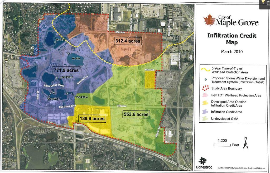
 Arbor Lakes Infiltration Credit: Maple Grove The Gravel Mining Area (GMA) at Arbor Lakes in Maple Grove is developing in accordance with a Stormwater Master Plan")
33 The Shingle Creek and West Mississippi Commissions approved two regional treatment systems that are incorporated into these Rules and Standards. SC Gravel Mining Area (GMA) Arbor Lakes Infiltration Credit: Maple Grove The Gravel Mining Area (GMA) at Arbor Lakes in Maple Grove is developing in accordance with a Stormwater Master Plan reviewed and approved by the Shingle Creek Commission. This Master Plan was developed in accordance with the Commission s runoff rate and water quality rules and standards, but before an infiltration requirement was added. There is a large area of the GMA yet to be developed where regional ponds have already been built according to the pre-infiltration requirement. In 2010 the Commission reviewed and approved a plan by the City of Maple Grove to obtain infiltration credits for this new development by constructing biofiltration basins adjacent to four existing regional stormwater ponds. Stormwater from areas that developed prior to the infiltration rule is directed to these new basins. The Commission agreed that these new infiltration basins are adequate to provide regional infiltration for the 553 acres of undeveloped area shown on the attached infiltration credit map. New development in that area will not be required to meet the infiltration standard on site. WM Brooklyn Center Regional Treatment In 2007 the City of Brooklyn Center constructed a regional treatment system for a large part of the area that is drained by the 65 th Avenue trunk storm sewer that outlets to the Mississippi River. This drainage area has little or no treatment. The area is expected to redevelop in the future, and the regional underground treatment system was proposed to provide regional TSS treatment. The treatment device was sized to provide treatment for the equivalent of the runoff from 360 acres. The West Mississippi Commission agreed that future development within that area would not need to provide on-site TSS treatment, and that the TP requirement could be met by infiltrating 0.75 inches of runoff from impervious area. Within the ten year time-of-travel area infiltration is not required, but filtration of the equivalent volume is required if allowed by the Wellhead Protection Plan. Projects will still need to meet rate control, erosion control, and other Commission requirements. Figure 2. Brooklyn Center Regional Treatment area.
34
Chapter 21 Stormwater Management Bylaw
 Chapter 21 Stormwater Management Bylaw SECTION 1. PURPOSE The purpose of this Bylaw is to: implement the requirements of the National Pollutant Discharge Elimination System (NPDES) General Permit for Storm
Ordinance No Lot Surface Drainage
 Ordinance No. 35-2008 - Lot Surface Drainage The Township has adopted a new Lot Surface Drainage Ordinance which amends Chapter 170, Article IX, Subdivision and Site Plan Review by adding a new Section
NEW CASTLE CONSERVATION DISTRICT. through. (Name of Municipality) PLAN REVIEW APPLICATION DRAINAGE, STORMWATER MANAGEMENT, EROSION & SEDIMENT CONTROL
 PLAN REVIEW APPLICATION DRAINAGE, STORMWATER MANAGEMENT, EROSION & SEDIMENT CONTROL") NEW CASTLE CONSERVATION DISTRICT through (Name of Municipality) PLAN REVIEW APPLICATION DRAINAGE, STORMWATER MANAGEMENT, EROSION & SEDIMENT CONTROL Office use only: Received by Municipality: Received by
NEW CASTLE CONSERVATION DISTRICT through (Name of Municipality) PLAN REVIEW APPLICATION DRAINAGE, STORMWATER MANAGEMENT, EROSION & SEDIMENT CONTROL Office use only: Received by Municipality: Received by
CHAPTER 6 ADDITIONAL STANDARDS APPLYING TO SHORELAND AREAS AND PUBLIC WATERS
 CHAPTER 6 ADDITIONAL STANDARDS APPLYING TO SHORELAND AREAS AND PUBLIC WATERS Section 1 Intent. 49 Section 2 Floodplain Requirements 49 Section 3 Water-Oriented Accessory Structures 50 Section 4 Stairways,
COON CREEK WATERSHED DISTRICT PERMIT REVIEW. Spring Lake Park Schools Westwood Middle School st Avenue NE, Spring Lake Park, MN 55432
 PAN 16-112, Westwood Middle School, Page 1 of 6 COON CREEK WATERSHED DISTRICT PERMIT REVIEW MEETING DATE: August 22, 2016 AGENDA NUMBER: 10 FILE NUMBER: 16-112 ITEM: Westwood Middle School RECOMMENDATION:
Municipal Stormwater Ordinances Summary Table
 APPENDIX F Municipal Ordinances Summary Table Municipality Abington Bryn Athyn Borough Hatboro Borough Ordinance, SALDO Runoff equals pre post Erosion Sediment Control Water Quality Requirements Any which
Pennsylvania Stormwater Best Management Practices Manual. Chapter 3. Stormwater Management Principles and Recommended Control Guidelines
 Pennsylvania Stormwater Best Management Practices Manual Chapter 3 Stormwater Management Principles and Recommended Control Guidelines 363-0300-002 / December 30, 2006 Chapter 3 Stormwater Management Principles
3.0 Planning and Submittal Requirements
 October 2003, Revised February 2005 Chapter 3.0, Planning and Submittal Requirements Page 1 3.0 Planning and Submittal Requirements 3.1 Drainage Studies and Drawings The City of Greenwood Village (Village)
Chapter 4. Drainage Report and Construction Drawing Submittal Requirements
 4.0 Introduction The requirements presented in this section shall be used to aid the design engineer or applicant in the preparation of drainage reports, drainage studies, and construction drawings for
Erosion & Sedimentation Control Policy
 Issue Date 10/22/2010 Page 1 of 8 Erosion & Sedimentation Control Policy Introduction: Soil erosion is the removal of soil by water, wind, ice or gravity and sediment deposition occurs when the rate of
STORMWATER AND EROSION CONTROL PERMIT
 STORMWATER MANAGEMENT AND EROSION CONTROL PERMIT INSTRUCTIONS AND INFORMATION Any project that involves the disturbance of ANY quantity of land requires the applicant to receive approval for the project
STORMWATER RUNOFF AND WATER QUALITY IMPACT REVIEW
 SUBCHAPTER 8 STORMWATER RUNOFF AND WATER QUALITY IMPACT REVIEW 7:45-8.1 Purpose and scope of review Except for those projects expressly exempted by this chapter or waived by the Commission, the Commission
ARTICLE A. POST-DEVELOPMENT STORMWATER MANAGEMENT FOR NEW DEVELOPMENT AND REDEVELOPMENT
 CHAPTER 11. STORMWATER MANAGEMENT ARTICLE A. POST-DEVELOPMENT STORMWATER MANAGEMENT FOR NEW DEVELOPMENT AND REDEVELOPMENT DIVISION 1. GENERALLY Sec. 10-11001. FINDINGS It is hereby determined that: (1)
E. STORMWATER MANAGEMENT
 E. STORMWATER MANAGEMENT 1. Existing Conditions The Project Site is located within the Lower Hudson Watershed. According to the New York State Department of Environmental Conservation (NYSDEC), Lower Hudson
ORDINANCE 9: WATERSHED MANAGEMENT
 Ordinance 9 ORDINANCE 9: WATERSHED MANAGEMENT CHAPTER 1: NORTH CANNON RIVER WMO... 180 179 ORDINANCE 9: WATERSHED MANAGEMENT Chapter 1: North Cannon River WMO AN ORDINANCE ESTABLISHING EROSION CONTROL
Storm Water Management Standards
 Storm Water Management Standards The City of Roseville has developed specific requirements that apply to development and redevelopment projects. These standards are intended to help achieve the water resource
S.O.P. No. HMD
 Page: 1 of 9 PURPOSE: To establish (SOP) for submission requirements, review process and approval of applications for Non-vehicular Access Permits for the purpose of connection or discharge to any MassDOT
SECTION V CHAPTER 12 STORMWATER POLLUTION PREVENTION POLICY
 1. PURPOSE: SECTION V CHAPTER 12 STORMWATER POLLUTION PREVENTION POLICY The purpose of this policy is to establish procedures to facilitate compliance with federal, state and local stormwater regulations
FACT SHEET GENERAL KPDES PERMIT FOR STORM WATER POINT SOURCE DISCHARGES CONSTRUCTION ACTIVITIES
 FACT SHEET GENERAL KPDES PERMIT FOR STORM WATER POINT SOURCE DISCHARGES CONSTRUCTION ACTIVITIES 1. COVERAGE UNDER THIS GENERAL PERMIT Area of Coverage: This permit covers all areas of the Commonwealth
Stormwater Management Studies PDS Engineering Services Division ES Policy # 3-01
 Stormwater Management Studies PDS Engineering Services Division Revised Date: 2/28/08 INTRODUCTION The City of Overland Park requires submission of a stormwater management study as part of the development
Stormwater Local Design Manual For Houston County, Georgia
 Stormwater Local Design Manual For Houston County, Georgia Adopted November 15, 2005 TABLE OF CONTENTS 1. FORWARD... 1 2. GENERAL LEVEL OF SERVICE STANDARDS... 2 2.1. DETENTION REQUIREMENTS... 2 2.1.1.
SECTION 4 SURFACE WATER MANAGEMENT DESIGN AND CONSTRUCTION REQUIREMENTS
 SECTION 4 SURFACE WATER MANAGEMENT DESIGN AND CONSTRUCTION REQUIREMENTS Page 4-1 INTRODUCTION 4-3 4-1.01 Applicability of VMCs 14.24, 14.25, 14.26 4-4 4-1.02 Minimum Requirements - Projects Below Threshold
SECTION 3 DRAINAGE. 3-1 General. 3-2 Drainage Ordinances and Legal Requirements
 SECTION 3 DRAINAGE 3-1 General All Drainage plans for proposed development shall be prepared by a Professional Engineer registered in Virginia, except as noted below. Further, their seal and signature
POLICY FOR NATURAL RESOURCE MANAGEMENT AREAS
 POLICY FOR NATURAL RESOURCE MANAGEMENT AREAS I. POLICY STATEMENT Auburn University's (the University's) "Policy for Natural Resource Management Areas" implements the Campus Master Plan Land Use Element
New Castle County, DE. Floodplain Regulations
 New Castle County, DE Floodplain Regulations John J. Gysling, PE CFM Department of Land Use New Castle County, DE February 26, 2009 Today s Presentation Floodplain Protection and Uses Terms and Definitions
MODEL Stormwater Local Design Manual. City of Centerville
 MODEL Stormwater Local Design Manual City of Centerville Adopted December 6, 2005 TABLE OF CONTENTS 1. FORWARD... 1 2. GENERAL LEVEL OF SERVICE STANDARDS... 1 2.1. DETENTION REQUIREMENTS... 1 2.1.1. Discharge
Ingham County Drain Commissioner Patrick E. Lindemann 707 BUHL AVENUE P. O. BOX 220 MASON MI PH. (517) FAX (517)
 FAX (517)") Date Issued Ingham County Drain Commissioner Patrick E. Lindemann 707 BUHL AVENUE P. O. BOX 220 MASON MI 48854 PH. (517) 676-8395 FAX (517) 676-8364 APPLICATION FOR SOIL EROSION AND SEDIMENTATION POLLUTION
Date Issued Ingham County Drain Commissioner Patrick E. Lindemann 707 BUHL AVENUE P. O. BOX 220 MASON MI 48854 PH. (517) 676-8395 FAX (517) 676-8364 APPLICATION FOR SOIL EROSION AND SEDIMENTATION POLLUTION
Ordinance amending the San Francisco Public Works Code by adding Article 4.2,
 FILE NO. ORDINANCE NO. 1 [Stormwater Management.] Ordinance amending the San Francisco Public Works Code by adding Article., sections., requiring the development and maintenance of stormwater management
MS4 Programs: Quality, the Other Stormwater Q. Dan Bounds, PE, D.WRE IAFSM March 9, 2017
 MS4 Programs: Quality, the Other Stormwater Q Dan Bounds, PE, D.WRE IAFSM March 9, 2017 MS4 Rule and Regulations MS4 Municipal Separate Storm Sewer System A conveyance or system of conveyances (catch basins,
Understanding Stormwater Pollution Prevention Plans (SWPPPs) (SWPPPS)
 (SWPPPS)") Understanding Stormwater Pollution Prevention Plans (SWPPPs) (SWPPPS) Definitions SWPPP: Storm Water Pollution Prevention Plan BMP: Best Management Practice(s) to control pollution IDNR: Iowa Department
Understanding Stormwater Pollution Prevention Plans (SWPPPs) (SWPPPS) Definitions SWPPP: Storm Water Pollution Prevention Plan BMP: Best Management Practice(s) to control pollution IDNR: Iowa Department
ENVIRONMENTAL RESOURCE PERMIT APPLICATION
 ENVIRONMENTAL RESOURCE PERMIT APPLICATION SOUTHWEST FLORIDA WATER MANAGEMENT DISTRICT 2379 BROAD STREET, BROOKSVILLE, FL 34604-6899 (352) 796-7211 OR FLORIDA WATS 1 (800) 423-1476 SECTION E INFORMATION
UMD Storm Water Program Construction Requirements. Greg Archer, MBA Environmental Compliance Specialist
 UMD Storm Water Program Construction Requirements Greg Archer, MBA Environmental Compliance Specialist Phase 2 Regulatory Overview Dec. 1999 EPA issues Phase 2 Federal Register Municipalities (MS4) from
WELCOME TO THE CONSTRUCTION STORMWATER PERMIT WEBINAR
 WELCOME TO THE CONSTRUCTION STORMWATER PERMIT WEBINAR All the documents shown today are in the MN Stormwater Manual on the page titled 2018 Construction Stormwater Permit Public Notice and Public Informational
City of Fairmont Storm Water Pollution Prevention Plan (SWPPP) January 23, 2017
 January 23, 2017") City of Fairmont Storm Water Pollution Prevention Plan (SWPPP) January 23, 2017 Why is Water Quality Important? Water has always been important to Minnesota and is a key part of our history, culture, economy
City of Fairmont Storm Water Pollution Prevention Plan (SWPPP) January 23, 2017 Why is Water Quality Important? Water has always been important to Minnesota and is a key part of our history, culture, economy
Background / Regulatory Requirements
 Chapter 2 Background / Regulatory Requirements This Chapter summarizes the impacts of development on stormwater quality and quantity and explains the postconstruction stormwater control requirements for
6.0 Runoff. 6.1 Introduction. 6.2 Flood Control Design Runoff
 October 2003, Revised February 2005 Chapter 6.0, Runoff Page 1 6.1 Introduction 6.0 Runoff The timing, peak rates of discharge, and volume of stormwater runoff are the primary considerations in the design
16.0 Water Quality Management Criteria for Developed Land
 October 2003, Revised February 2005 Criteria for Developed Land Page 1 16.1 Introduction 16.0 Water Quality Management Criteria for Developed Land Stormwater quality control is an integral part of any
STORMWATER DISCHARGES ASSOCIATED WITH CONSTRUCTION ACTIVITY
 STATE OF COLORADO GENERAL PERMIT APPLICATION Updated 11/04 STORMWATER DISCHARGES ASSOCIATED WITH CONSTRUCTION ACTIVITY This application is for use by all stormwater dischargers engaged in construction
Chapter 6. Hydrology. 6.0 Introduction. 6.1 Design Rainfall
 6.0 Introduction This chapter summarizes methodology for determining rainfall and runoff information for the design of stormwater management facilities in the City. The methodology is based on the procedures
SECTION STORM DRAINAGE DESIGN, GRADING, AND WATER QUALITY TECHNICAL CRITERIA TABLE OF CONTENTS PAGE 402 STORM DRAINAGE DESIGN CRITERIA 400-1
 CITY OF THORNTON Standards and Specifications Revised: October 2012 SECTION 400 - STORM DRAINAGE DESIGN, GRADING, AND WATER QUALITY TECHNICAL CRITERIA TABLE OF CONTENTS PAGE 401 GENERAL PROVISIONS 400-1
CHAPTER 8 EROSION AND SEDIMENT CONTROL PLAN REQUIREMENTS
 CHAPTER 8 EROSION AND SEDIMENT CONTROL PLAN REQUIREMENTS 8.1 INTRODUCTION To minimize the detrimental effects of erosion and sedimentation, Henrico County requires that those individuals responsible for
CITY OF MONTCLAIR Montclair Civic Center 5111 Benito Street Montclair, CA 91763
 CITY OF MONTCLAIR Montclair Civic Center 5111 Benito Street Montclair, CA 91763 I. Introduction Water Quality A National, State, and Local Concern Throughout the United States, many rivers, creeks, streams,
SACHSE EROSION CONTROL GUIDELINES
 SACHSE EROSION CONTROL GUIDELINES Section I. Definitions The following words, terms, and phrases, when used in this guideline, shall have the meanings ascribed to them in this Section, except where the
CITY OF SPRING HILL Water Quality Buffer Zone Policy (Adopted April 22, 2008)
") Section I - Description CITY OF SPRING HILL Water Quality Buffer Zone Policy (Adopted April 22, 2008) A water quality buffer zone (a.k.a. a riparian zone) is a strip of undisturbed native (indigenous)
Section I - Description CITY OF SPRING HILL Water Quality Buffer Zone Policy (Adopted April 22, 2008) A water quality buffer zone (a.k.a. a riparian zone) is a strip of undisturbed native (indigenous)
APPENDIX H Guidance for Preparing/Reviewing CEQA Initial Studies and Environmental Impact Reports
 APPENDIX H H.1 Guidance for Preparing and Reviewing CEQA Initial Studies Step 1: Consider the Project Characteristics as Provided by the Project Applicant Review the project application and draft plan
Chapter 3 Dispersion BMPs
 Chapter 3 Dispersion BMPs 3.1 BMP L611 Concentrated Flow Dispersion 3.1.1 Purpose and Definition Dispersion of concentrated flows from driveways or other pavement through a vegetated pervious area attenuates
GRASS-LINED CHANNEL (acre) CODE 840
 CODE 840") NATURAL RESOURCES CONSERVATION SERVICE ILLINOIS URBAN MANUAL PRACTICE STANDARD GRASS-LINED CHANNEL (acre) CODE 840 (Source: NC Erosion and Sediment Control Field Manual) DEFINITION A natural or constructed
NATURAL RESOURCES CONSERVATION SERVICE ILLINOIS URBAN MANUAL PRACTICE STANDARD GRASS-LINED CHANNEL (acre) CODE 840 (Source: NC Erosion and Sediment Control Field Manual) DEFINITION A natural or constructed
IV. ENVIRONMENTAL IMPACT ANALYSIS G. HYDROLOGY/WATER QUALITY
 IV. ENVIRONMENTAL IMPACT ANALYSIS G. HYDROLOGY/WATER QUALITY ENVIRONMENTAL SETTING The project site is located in the Wilshire community of the City of Los Angeles and is bound by S. Wetherly Drive to
From Policy to Reality
 From Policy to Reality Updated ^ Model Ordinances for Sustainable Development 2000 Environmental Quality Board 2008 Minnesota Pollution Control Agency Funded by a Minnesota Pollution Control Agency Sustainable
STATE OF FLORIDA DEPARTMENT OF ENVIRONMENTAL PROTECTION GENERIC PERMIT FOR DISCHARGE OF STORMWATER FROM PHASE II
 STATE OF FLORIDA DEPARTMENT OF ENVIRONMENTAL PROTECTION GENERIC PERMIT FOR DISCHARGE OF STORMWATER FROM PHASE II MUNICIPAL SEPARATE STORM SEWER SYSTEMS May 1, 2003 1 Generic Permit for Discharge of Stormwater
CHAPTER 2 STORMWATER MANAGEMENT
 CHAPTER 2 STORMWATER MANAGEMENT REVISED SEPTEMBER 11, 2002 WHATCOM COUNTY DEVELOPMENT STANDARDS CHAPTER 2 - STORMWATER MANAGEMENT TABLE OF CONTENTS PART 1: ADMINISTRATIVE PROVISIONS Section 201. Regulatory
3 GOALS, POLICIES, AND MANAGEMENT STRATEGIES
 3 GOALS, POLICIES, AND MANAGEMENT STRATEGIES The roles of watershed districts have changed since the Lower Minnesota River Watershed District formed in 1960. These roles now reflect new public values,
Spartanburg County. Storm Water Management Design Manual
 Spartanburg County TABLE OF CONTENTS Section Title Page No. Table of Contents... i List of Tables......iii Chapter 1 Introduction... 1 1.1 Purpose of the Manual... 1 1.2 Description and Use of the Manual...
Surface Water and Non-Wetland Surface Waters Delineation and Classification pursuant Chapter F.A.C.
 Surface Water and Non-Wetland Surface Waters Delineation and Classification pursuant Chapter 62-340 F.A.C. What are Waters? 373.019 F.S. Definitions (20) Water or waters in the state means any and all
iswm TM Criteria Manual City of Azle Section 14 City of Azle Subdivision Ordinance DRAFT-June Chapter 1
 City of Azle Section 14 City of Azle Subdivision Ordinance DRAFT-June 2010... Chapter 1 i CITY OF AZLE iswm CRITERIA MANUAL FOR SITE DEVELOPMENT AND CONSTRUCTION Incorporating the Regional NCTCOG Integrated
Chapter 2 ADMINISTRATIVE PROCEDURES
 Chapter 2 2.01 General 2.01.1 Application of Chapter 2.01.2 Fees 2.02 Pre-Development Site Certification and Assessment 2.03 Construction Permits 2.03.1 Site Development Permit 2.03.2 Development Permits
CITY UTILITIES DESIGN STANDARDS MANUAL
 CITY UTILITIES DESIGN STANDARDS MANUAL () September 2017 Page Chapter 1 Acronyms and Definitions 1.01 Purpose 1 1.02 Acronyms 1 1.03 Definitions 3 Chapter 2 Introduction 2.01 Purpose 1 2.02 Applicability
JEFFERSON COUNTY STORM WATER MANAGEMENT
 JEFFERSON COUNTY STORM WATER MANAGEMENT B-210 Courthouse, Birmingham, Alabama 35203 Telephone: (205) 325-8741 Erosion and Sedimentation Control Measures for Commercial Projects (Plans Requirements) -All
Permit Section Ohio EPA Permit Change or Addition Model Ordinance Section to be Changed
 Permit Section Ohio EPA Permit Change or Addition Model Ordinance Section to be Changed Ordinance Controlling Construction Site Soil Erosion, Sediment, and Other Wastes and Storm Water Runoff Part III.G.2:
CITY OF ASTORIA PUBLIC WORKS ENGINEERING DIVISION ENGINEERING DESIGN STANDARDS FOR IN-FILL DEVELOPMENT
 CITY OF ASTORIA PUBLIC WORKS ENGINEERING DIVISION ENGINEERING DESIGN STANDARDS FOR IN-FILL DEVELOPMENT Adopted by City Council: May 21, 2007 X:\General Eng\DESIGN STANDARDS\Engineering Design Standards
Section 1 Non-Conforming Structures and Uses Allowed to Continue. 12
 CHAPTER 3 NONCONFORMITIES Section 1 Non-Conforming Structures and Uses Allowed to Continue. 12 Section 2 Discontinuance 12 Section 3 Change of Use... 12 Section 4 Residential Alterations 12 Section 5 Restoration..
Riparian Buffer Requirements. Department of Environmental Protection Bureau of Watershed Management
 102.14 - Riparian Buffer Requirements Department of Environmental Protection Bureau of Watershed Management 102.2 Scope and Purpose BMPs to protect, maintain, and restore water quality and existing designated
7/16/2012. Post Construction Best Management Practices (PCBMPs) Article VIII: Post Construction Best Management Practices
 Article VIII: Post Construction Best Management Practices") Post Construction Best Management Practices (PCBMPs) Article VIII: Post Construction Best Management Practices Presented by Jennifer Boyer DuPage County DEC Includes BMPs intended to provide volume control
Post Construction Best Management Practices (PCBMPs) Article VIII: Post Construction Best Management Practices Presented by Jennifer Boyer DuPage County DEC Includes BMPs intended to provide volume control
Richland County Department of Public Works Engineering (Land Development) Division
 Division") Richland County Department of Public Works Engineering (Land Development) Division Commercial Projects What is a Commercial Project? Projects that are not related to residential single family homes and/or
Richland County Department of Public Works Engineering (Land Development) Division Commercial Projects What is a Commercial Project? Projects that are not related to residential single family homes and/or
901 STORMWATER POLLUTION MANAGEMENT SECTION 901 STORMWATER POLLUTION MANAGEMENT
 SECTION 901 STORMWATER POLLUTION MANAGEMENT 901.1 DESCRIPTION Design, implement, inspect and maintain appropriate best management practices to minimize or eliminate erosion, sediment and other pollutants
Standards for Soil Erosion and Sediment Control in New Jersey May 2012 STANDARD FOR GRASSED WATERWAYS. Definition. Purpose
 STANDARD FOR GRASSED WATERWAYS Definition A natural or constructed watercourse shaped or graded in earth materials and stabilized with suitable vegetation for the safe conveyance of runoff water. Purpose
Environmental Management Chapter ALABAMA DEPARTMENT OF ENVIRONMENTAL MANAGEMENT WATER DIVISION - WATER QUALITY PROGRAM ADMINISTRATIVE CODE
 Environmental Management Chapter 335-6-9 ALABAMA DEPARTMENT OF ENVIRONMENTAL MANAGEMENT WATER DIVISION - WATER QUALITY PROGRAM ADMINISTRATIVE CODE CHAPTER 335-6-9 SURFACE MINING RULES TABLE OF CONTENTS
KENOSHA COUNTY STORMWATER MANAGEMENT, EROSION CONTROL, AND ILLICIT DISCHARGE ORDINANCE CHAPTER 17 OF THE MUNICIPAL CODE OF KENOSHA COUNTY
 KENOSHA COUNTY STORMWATER MANAGEMENT, EROSION CONTROL, AND ILLICIT DISCHARGE ORDINANCE BEING CHAPTER 17 OF THE MUNICIPAL CODE OF KENOSHA COUNTY EFFECTIVE DATE 03/05/2010 REVISION DATES 01/21/2016 06/09/2016
Constructed Wetland Pond T-8
 Constructed Wetland Pond T-8 Description A constructed wetlands pond is a shallow retention pond designed to permit the growth of wetland plants such as rushes, willows, and cattails. Constructed wetlands
Infiltration Guidelines
 Appendix E Infiltration Guidelines As a stormwater management method, infiltration means retaining or detaining water within soils to reduce runoff. Infiltration can be a cost-effective method to manage
Streamlines V2, n2 (May 1997) A Newsletter for North Carolina Water Supply Watershed Administrators
 A Newsletter for North Carolina Water Supply Watershed Administrators") Page 1 of 5 STREAMLINES A Newsletter for North Carolina Water Supply Watershed Administrators Volume 2, Number 2 May 1997 Non-Point Source (NPS) Pollution This issue of Streamlines provides basic information
Page 1 of 5 STREAMLINES A Newsletter for North Carolina Water Supply Watershed Administrators Volume 2, Number 2 May 1997 Non-Point Source (NPS) Pollution This issue of Streamlines provides basic information
Stormwater Management Standards
 Stormwater Management Standards In 1996, the Massachusetts Department of Environmental Protection (the Department or MassDEP ) issued the Stormwater Policy that established Stormwater Management Standards
DRAINAGE AND NATURAL AQUIFER GROUNDWATER RECHARGE ELEMENT
 Goal 7.0. To optimize integrated stormwater management in order to reduce damage and impacts from sea level rise and flooding, promotes recharge to the Surficial Aquifer System (SAS), improve and protect
DEVELOPMENT CODE REVISIONS CHAPTER 6 1 CASE # RESO # SECTION/DESCRIPTION DATE , 6206, 6207, /09/03
 DEVELOPMENT CODE REVISIONS CHAPTER 6 1 CASE # RESO # SECTION/DESCRIPTION DATE 03-005 03-45 6102.01, 6206, 6207, 6402 06/09/03 03-061 03-71 Deleted berm regs (moved to Chapter 3) 9/8/03 04-077 07-44 Comprehensive
MACOMB COUNTY SOIL EROSION AND SEDIMENTATION CONTROL ORDINANCE. Adopted August 16, 2007 by Resolution of the Macomb County Board of Commissioners
 MACOMB COUNTY SOIL EROSION AND SEDIMENTATION CONTROL ORDINANCE Adopted August 16, 2007 by Resolution of the Macomb County Board of Commissioners ADOPTED BY REFERENCE INTO THIS ORDINANCE IS PART 91 OF ACT
RULES OF GEORGIA DEPARTMENT OF NATURAL RESOURCES ENVIRONMENTAL PROTECTION DIVISION CHAPTER EROSION AND SEDIMENTATION CONTROL TABLE OF CONTENTS
 RULES OF GEORGIA DEPARTMENT OF NATURAL RESOURCES ENVIRONMENTAL PROTECTION DIVISION CHAPTER 391-3-7 EROSION AND SEDIMENTATION CONTROL TABLE OF CONTENTS 391-3-7.01 Definitions. 391-3-7.02 (Repealed) 391-3-7.03
SECTION 17.1 STORMWATER MANAGEMENT AND EROSION CONTROL
 SECTION 17.1 STORMWATER MANAGEMENT AND EROSION CONTROL Subdivision 1: Purpose Subdivision 2: Scope Subdivision 3: Definitions Subdivision 4: Permit Application and Plan Subdivision 5: Stormwater Pollution
Implementing Stormwater Management through Split-Flow Drainage Design
 Implementing Stormwater Management through Split-Flow Drainage Design Stuart Patton Echols PhD, ASLA, RLA Assistant Professor - Department of Landscape Architecture 210 Engineering Unit D Center for Watershed
APPLICATION FOR PUBLIC INFRASTRUCTURE PERMIT
 APPLICATION FOR PUBLIC INFRASTRUCTURE PERMIT Engineering Division 550 Landa Street New Braunfels, Texas 78130 (830) 221-4020 1. Subdivision Plat Name: Location Description/ Nearest Intersection: Acreage:
CHAPTER 9 STORMWATER MANAGEMENT PLAN REQUIREMENTS
 CHAPTER 9 9.1 INTRODUCTION The Virginia Stormwater Management Program (VSMP) Act and Regulations require that Henrico County adopt a local program to administer the requirements. The requirements are addressed
CHAPTER 7 - INFRASTRUCTURE INSPECTION AND ACCEPTANCE... 2
 CHAPTER 7 - INFRASTRUCTURE INSPECTION AND ACCEPTANCE... 2 7.1. GENERAL.... 2 7.1.1. Inspection Restriction Dates.... 2 7.1.2. Complete Improvements.... 2 7.1.3. Public Improvements.... 2 7.1.4. Warranty
Nutrient Management in. A presentation to the West Metro Water Alliance
 Nutrient Management in Developing and Agricultural Areas A presentation to the West Metro Water Alliance Chris Meehan, P.E. May 25, 2011 Agenda Physical Improvements Planning Improvements How to get it
Agricultural/Rural Riparian Buffer Analysis
 Agricultural/Rural Riparian Buffer Analysis December 2014 Executive Summary The Agricultural/Rural Riparian Buffer Analysis was developed from a 2014 analysis of current requirements for the riparian areas
GRADING & DRAINAGE PERMIT SOIL EROSION AND SEDIMENTATION CONTROL PERMIT PROGRAM OVERVIEW
 GRADING & DRAINAGE PERMIT SOIL EROSION AND SEDIMENTATION CONTROL PERMIT PROGRAM OVERVIEW Chapter 8 Building and Building Regulations, Article XIII Grading and Drainage and Article XV Soil Erosion and Sedimentation
SECTION 2 DESIGN CRITERIA
 SECTION 2 DESIGN CRITERIA 2.1 GENERAL The following criteria will be utilized by the District Engineer, and/or a consultant, in the review of development plans for recommending approval of the proposed
UC SANTA CRUZ EROSION AND SEDIMENT CONTROL STANDARDS FOR PROJECTS UNDER ONE ACRE
 CAMPUS STANDARDS APPENDIX D UC SANTA CRUZ EROSION AND SEDIMENT CONTROL STANDARDS FOR PROJECTS UNDER ONE ACRE July 9, 2012 UCSC Campus Standards Handbook Erosion and Sediment Control Standards Appendix
Chapter 7. Street Drainage. 7.0 Introduction. 7.1 Function of Streets in the Drainage System. 7.2 Street Classification
 7. Introduction This chapter summarizes methods to evaluate runoff conveyance in various street cross sections and curb types in the Town of Castle Rock and identifies acceptable upper limits of street
VIRGINIA POLLUTION ABATEMENT (VPA) PERMIT APPLICATION. FORM B - ANIMAL FEEDING OPERATIONS (AFOs)
 PERMIT APPLICATION. FORM B - ANIMAL FEEDING OPERATIONS (AFOs)") VIRGINIA POLLUTION ABATEMENT (VPA) PERMIT APPLICATION FORM B - ANIMAL FEEDING OPERATIONS (AFOs) Department of Environmental Quality Rev. 02-2013 VIRGINIA POLLUTION ABATEMENT (VPA) PERMIT APPLICATION FORM
VIRGINIA POLLUTION ABATEMENT (VPA) PERMIT APPLICATION FORM B - ANIMAL FEEDING OPERATIONS (AFOs) Department of Environmental Quality Rev. 02-2013 VIRGINIA POLLUTION ABATEMENT (VPA) PERMIT APPLICATION FORM
Hydrology 101. Impacts of the Urban Environment. Nokomis Knolls Pond Summer June 2008
 Hydrology 101 Nokomis Knolls Pond Summer 2002 Impacts of the Urban Environment Hydrologic Cycle; What is it? Geography, Topography, Geology, Land Cover and Climate determine the Amount and Behavior of
CHAPTER 3 Environmental Guidelines for WATERCOURSE CROSSINGS GOVERNMENT OF NEWFOUNDLAND AND LABRADOR DEPARTMENT OF ENVIRONMENT AND LABOUR
 GOVERNMENT OF NEWFOUNDLAND AND LABRADOR DEPARTMENT OF ENVIRONMENT AND LABOUR CHAPTER 3 Environmental Guidelines for WATERCOURSE CROSSINGS WATER RESOURCES MANAGEMENT DIVISION Water Investigations Section
BMP #: Infiltration Basin
 Structural BMP Criteria BMP #: Infiltration Basin An Infiltration Basin is a shallow impoundment that stores and infiltrates runoff over a level, subtle, uncompacted, (preferably undisturbed area) with
Regulatory Requirements
 CHAPTER 1 Regulatory Requirements 1.0 Introduction The negative impacts of unmanaged stormwater runoff present a challenge to the City of Philadelphia, including increased runoff pollutant concentrations,
RICE CREEK WATERSHED DISTRICT RULES
 RICE CREEK WATERSHED DISTRICT RULES BOARD APPROVED: DECEMBER 14, 2016 EFFECTIVE DATE: JANUARY 1, 2017 TABLE OF CONTENTS Page # CERTIFICATION 3 GENERAL POLICY STATEMENT 4 RELATIONSHIP OF RICE CREEK WATERSHED
GENERAL SPECIFICATION FOR ENVIRONMENTAL PROTECTION FOR CONSTRUCTION IN WATERBODIES AND ON WATERBODY BANKS
 ONTARIO PROVINCIAL STANDARD SPECIFICATION METRIC OPSS.PROV 182 NOVEMBER 2012 GENERAL SPECIFICATION FOR ENVIRONMENTAL PROTECTION FOR CONSTRUCTION IN WATERBODIES AND ON WATERBODY BANKS TABLE OF CONTENTS
Suffolk Downs Redevelopment. Appendix G: Stormwater Management Supporting Documentation
 Suffolk Downs Redevelopment Expanded PNF Appendix G: Stormwater Management Supporting Documentation Suffolk Downs Redevelopment Phase 1 Stormwater Management Report Boston, Massachusetts 285402RP004 TABLE
C Fish Lake C Rice Lake C Mud Lake C Weaver Lake C Elm Creek*
 IV. PROBLEMS AND CORRECTIVE ACTIONS Outlined below is an assessment of existing and potential water resource-related issues that are known at this time. These issues have been identified based on Commission
STATE OF MINNESOTA MINNESOTA POLLUTION CONTROL AGENCY FINDINGS OF FACT
 STATE OF MINNESOTA MINNESOTA POLLUTION CONTROL AGENCY IN THE MATTER OF THE DECISION ON THE NEED FOR AN ENVIRONMENTAL IMPACT STATEMENT FOR THE PROPOSED LESTER PRAIRIE WASTEWATER TREATMENT FACILITY EXPANSION
4.8. Subsurface Infiltration
 4.8. Subsurface Infiltration Subsurface infiltration systems are designed to provide temporary below grade storage infiltration of storm water as it infiltrates into the ground. Dry wells, infiltration
City of Gig Harbor Stormwater Management and Site Development Manual
 City of Gig Harbor Stormwater Management and Site Development Manual Volume I Minimum Technical Requirements and Site Planning Prepared by: Pierce County Surface Water Management Approved by City of Gig
4.8. Subsurface Infiltration
 4.8. Subsurface Infiltration Subsurface infiltration systems are designed to provide temporary below grade storage infiltration of stormwater as it infiltrates into the ground. Dry wells, infiltration