Watershed hydrology and catchment response
|
|
|
- Piers Fletcher
- 6 years ago
- Views:
Transcription
1 Watershed hydrology and catchment response
2 Motivation Studying stream response to water input events (catchment response) is important for: Water supply: Precipitation falling in the ground and then moving through stream networks represents a resource for agricultural, municipal and recreational water use. Flood prediction and forecasting: Flood forecasting, the design of dams, bridges and levees, and developing floodplain management plans requires knowing how streams will respond to precipitation events. Water quality: Water quality is strongly influenced by chemical and biological reactions as water moves over the land surface and then into streams.

3 Watershed hierarchy Small watersheds (e.g., a few km 2 ) can be part of bigger watersheds, and bigger watersheds can be part of even bigger watersheds. The example at right is the Patuxent river watershed, which drains into Chesapeake Bay. The biggest watershed in the U.S.A. is the Mississippi watershed; our own Boulder Creek watershed (or drainage) is part of the South Platte drainage, which is part of the Missouri drainage, which is part of the Mississippi drainage.

 http://czo.colorado.edu/html/sites.")
4 Viewed with respect to the Mississippi drainage as a whole, the Boulder Creek drainage seems very small. Boulder Creek is itself comprised of a number of smaller watersheds. Watershed hierarchy (cont.)
, modified from Horton (1945).")
5 Stream order Streams can be defined in terms of their order. The joining of two first-order streams creates a second-order stream. The joining of two second order streams creates a third-order stream, and so forth. This system was developed by Strahler (1952), modified from Horton (1945). The Ohio River is an 8 th order stream, the Mississippi is a tenth order stream. The Amazon, the worlds largest river, is a 12 th order stream. Anything 7 th order and up is typically viewed as a river, but this is not a hard and fast rule in practice /stream/stream11.html
.")
6 Drainage patterns Dendritic: The most common form. It develops in regions underlain by homogeneous material (the subsurface geology has a similar resistance to weathering so there is no apparent control over the direction the tributaries take). Tributaries join larger streams at acute angle (less than 90 degrees) Parallel: Forms where there is a pronounced slope to the surface. A parallel pattern also develops in regions of parallel, elongate landforms like outcropping resistant rock bands. Tributary streams tend to stretch out in a parallel-like fashion following the slope of the surface. A parallel pattern sometimes indicates the presence of a major fault that cuts across an area of steeply folded bedrock. Trellis: Develops in folded topography like that found in the Appalachian Mountains of North America. Synclines form valleys where the main channel of the stream is found. Short tributary streams enter the main channel at sharp angles as they run down sides of parallel ridges (anticlines) Tributaries join the main stream at nearly right angles.


7 Drainage patterns (cont.) Rectangular: Found in regions that have undergone faulting. Streams follow the path of least resistance and thus are concentrated in places were exposed rock is the weakest. Movement of the surface due to faulting off-sets the direction of the stream. As a result, the tributary streams make shape bends and enter the main stream at large angles. Radial: Develop around a central elevated point. This pattern is common to conically shaped features such as volcanoes. The tributary streams extend the headward reaches upslope toward the top of the volcano. Centripetal: The opposite of the radial as streams flow toward a central depression. Pattern is common in the Basin and Range province of the United States where many basins exhibit interior drainage. Deranged: Develop from the disruption of a pre-existing drainage pattern, such as when a dendritic pattern is overrun by a glacier. atterns.html
 where the stage is defined as zero.")
8 Measuring streamflow Measuring streamflow (discharge) generally involves four steps: 1) Measuring stream stage: This involves continuous measurement of the height of the water surface at a location along a stream with reference to some established altitude (close to the stream bed) where the stage is defined as zero. 2) Measuring discharge: Instruments are used to measure stream discharge 3) A relationship is formed between measured stage and measured discharge 4) Once the relationships is formed, then one can use stage information to get discharge. One must monitor the stage/discharge relationship as it may change.

 http://ga.water.usgs.")
9 Measuring streamflow (cont) A typical USGS stream gauge that measures stage ( /streamflow1.html)
 http://ga.water.usgs.")

10 Measuring streamflow (cont.)

11 Daily Snowmelt Input Rain / Snowmelt

12 Streamflow response is rapid in small catchments. Not all event precipitation becomes runoff Response to event is variable.
13 Basic aspects of stream response Consider a small upland watershed. Precipitation may move into a stream from overland flow or as a groundwater flow. The streamflow (the flow that would be gauged at a particular point) is a spatially and temporally integrated response to: (1) spatially and temporally varying water input rates; (2) the time it takes for a given drop of water to travel from where it strikes the surface of the watershed to where it enters the stream network; (3) the time it takes for the water to travel from where it enters the stream channel to the point of measurement. Dingman 2002, Figure 9-1
14 Flowpaths
15 A typical storm response The figure at the right shows a typical hydrograph of a stream in response to a isolated precipitation event of significant magnitude and areal extent. At the gauging site, one is measuring the passage of a flood wave. The nature of the this wave (shape, amplitude, duration) depends on precipitation intensity, extent, duration (as seen in the hyetograph) and form, topography, soils (which affect infiltration), and the density of the stream channel network. In a small (less than 50 km 2 ) watershed, the travel time of water to a watershed outlet is primarily a function of the hillslope travel time; for larger watersheds, travel time in the stream network is more important. If the precipitation event is snowfall, there can be a long lag (even seasonal) in streamflow response. Dingman 2002, Figure 9-2
 by time (y axis) Hyetograph: A graph of water input (y axis) versus time.")

16 Some terminology Watershed, catchment, drainage basin: three names for the same thing Hydrograph: A graph of stream discharge at a point (x axis) by time (y axis) Hyetograph: A graph of water input (y axis) versus time. Peak discharge: The value of maximum streamflow in response to a water input event that follows the hydrographic rise and is then followed by the hydrographic recession. hydrograph watershed hyetograph commons.wikimedia.org
17 Contributing area The water in a stream identified as the response to a given precipitation event can originate from only a small fraction of the watershed,; this fraction is termed the contributing area. For an event such as an isolated thunderstorms, the contributing area could be small (several km 2 ); for a more general precipitation event, the contributing area can be much larger (hundreds of even thousands of km 2 ), which, depending on the size of the watershed being considered, may cover most or all of the watershed. The extent of and location of the contributing area may change during the course of a precipitation event.
18 Hydrograph response The figure at right shows hydrographs for a series of gauging stations progressively downstream along the Sleepers River in Danville VT in response to a intense rainfall event (hyetograph at the top). Note how the hydrograph shape for the smallest (top) watershed is closely allied with the shape of the hytograph. Lower downstream, the hydrographs are increasingly affected by tributary inputs and storage effects of the stream channels, leading to an increase in the lag time between precipitation input and the hydrograph peaks, as well as smoother hydrographs. Dingman 2002, Figure 9-3
19 Hydrograph separation Streamflow can be separated into the contribution from event flow Q ef taken to be the direct response to a given water input, and a base flow Q b not associated with a specific event, commonly (albeit not always correctly) assumed to be due to ground water inputs. The figure at right shows a hyetograph for an isolated rainfall event of about 24 hours duration (Sleepers River, Danville VT) and the corresponding hydrograph. In this case, Q b could be estimated as the low flow before the rainfall event. However, in practice, separating Q b from Q ef can be very difficult. For example, a stream might be still responding to a past precipitation event or series of events at the time when a new precipitation even occurs. Graphical separation methods and chemical tracers provide ways of separating base flow from event flow. Dingman 2002, Figure 9-4.

20 There are several ways to separate Event Flow from Base Flow Event Flow
, 3 H (Tritium) Geochemical tracers: 2+ Ca, 2+ Mg, + Na, - Cl, - HCO 3, 2-")
21 New Water (Event water) vs Old Water (Pre-event water) Environmental isotopes: 16 O, 18 O, 1 H, 2 H (Deuterium), 3 H (Tritium) Geochemical tracers: 2+ Ca, 2+ Mg, + Na, - Cl, - HCO 3, 2- SO 4

22 Event flow For most regions, the ratio of event flow Q ef to total rainfall W is considerably less that 0.5 and often less that 0.1. The figure at right shows the ratio expressed as a percentage for the southeastern United States. Note the strong spatial variability. These results indicate that much of the streamflow travels to streams via delayed routes as base flow, in large part due to regional groundwater flows Dingman 2002, Figure 9-6
23 Event flow (cont) The ratio Q ef /W also varies strongly from event to event for a given watershed. The figure at right shows hytographs and corresponding hydrographs for two similar summer storms on a small1.6 km 2 watershed at Barrow, AK. For the first event, Q ef /W is 0.63; for the second event, Q ef /W is The first event was during a very wet summer while the second was during a very dry summer. Much of the precipitation went into soil moisture recharge in the second case. Dingman 2002, Figure 9-9
24 Event flow (cont) The analysis and modeling of event hyetographs and response hydrographs involves a dedicated terminology Dingman 2002, Table 9-1 Dingman 2002, Figure 9-10

25 Hydrograph shape Hydrograph shape and the terms describing hydrograph response in the previous figure are determined by storm size, watershed size, soils and geology, slope and land use. Consider the two situations at right. The lag time (the centroid lag T LC in the previous figure, taken as the time difference between the centroid of effective water input and centroid of the response hydrograph) is smaller over an urban watershed than over the agricultural watershed (we are considering response to the same hytograph in each case). This reflects the low hydraulic conductivity of the urban watershed (water falls on pavement, allowing for rapid surface runoff) compared to the agricultural watershed. In turn, the peak discharge is greater over the urban watershed.
 exceeds the saturation hydraulic conductivity K* h of the surface for a duration exceeding the time of ponding t p.")

26 Overland flow Overland flow is produced by two basic mechanisms 1) Infiltration excess, or Hortonian Overland Flow (panel at left) results from saturation from above where the water input rate w(t) exceeds the saturation hydraulic conductivity K* h of the surface for a duration exceeding the time of ponding t p. 2) Saturation (or Dunne) Overland Flow (panel at right) results from saturation from below ; water is added to the top, but the soil is saturated so that overland flow occurs. Saturation overland flow also includes return flow contributed by the breakout of ground water from upslope.
27 Overland flow (cont). Hortonian overland flow tends to be associated with conditions of high precipitation intensity (e.g., a decent thunderstorm), low soil permeability (clay, asphalt) and sparse vegetation. It appears a thin sheets of water (sheet flow), small threads of water, or rill erosion. The figure at right illustrates idealized relationships between the rate of Hortonian overland flow q ho (t) and the infiltration rate f(t) with a constant water input rate w(t). Note that: q ho (t) = w(t) f(t) Dingman 2002, Figure 9-19
 as well as in moist soils where the water table is near the surface.")
28 Overland flow (cont.) Compared to Hortonian overland flow, saturation excess overflow tends to occur with lower precipitation intensity and longer-duration precipitation events. It is favored with more permeable soils (along with lower precipitation intensity, this means that ponding is less likely) as well as in moist soils where the water table is near the surface. At the onset of precipitation, overland flow is absent and only regional ground water flow is occurring (top panel of figure). With continued precipitation, the water table rises and the surface becomes saturated. Once the surface is saturated, direct precipitation can no longer infiltrate and becomes runoff (bottom panel of figure). There can be a contribution to the saturation overland flow by a return flow contributed by breakout of groundwater from upslope regions. Return flow is usually, but not always, a fairly minor contributor to stream flow event response. In humid regions, saturated overland flow is the major mechanism producing event response. Dingman 2002, Figure 9-21
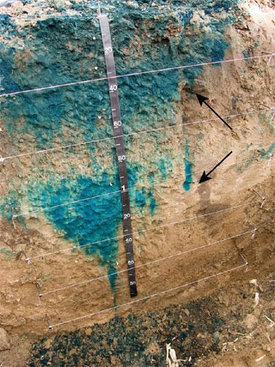
29 Overland flow (cont). While saturated overland flow tends to be most apparent near stream areas (where the soil is most likely to be saturated) it can also occur where subsurface water flow lines converge in slope concavities (hillslope hollows) (panel a at right), along slope breaks where the hydraulic gradient is reduced (panel b), where soil layers are locally thin (panel c) and where hydraulic conductivity changes (panel d), resulting in perched zones of saturation that reach the surface. Dingman 2002, Figure 9-22
 Within a given watershed, the extent of areas saturated from below varies widely with time, which is in large part responsible for the large variability of storm runoff observed in many regions.")
30 Overland flow (cont.) Within a given watershed, the extent of areas saturated from below varies widely with time, which is in large part responsible for the large variability of storm runoff observed in many regions. This is important for understanding and modeling event response. The example at right is for a drainage in central Vermont with gentle slopes and moderate to poorly drained soils. A s is the area that is saturated. Dingman 2002, Figure 9-23

31 Subsurface storm flow Regional groundwater flow is usually the source of most streamflow (base flow) between event responses. While residence times of groundwater are generally too great to contribute to event flow, conditions may occur in which such subsurface flow enters a stream quickly enough to make a contribution. This in termed subsurface storm flow. The figure at right shows a situation with subsurface storm flow above impermeable bedrock.
32 Subsurface storm flow (cont.) As the water table adjacent to streams in humid regions is near the surface, percolation recharges groundwater near stream areas before upslope locations, producing a mound in the water table, steepening the hydraulic gradient both towards and away from the stream. The steepened streamward gradient can give a sustained contribution to streamflow. In some situations, pressurization of the capillary fringe from percolation can rapidly produce a groundwater mound. The figure below shows the simulated response of the near-stream water table to pressurization of the capillary fringe from a rain event on sandy soil. The lines show the position of the water table at successive times after the onset of rain. Dingman 2002, Figure 9-25
33 Subsurface storm flow (cont.) In many regions, hillslopes have a thin layer of permeable soil, overlying relatively impermeable layers. Infiltration and percolation commonly produce a thin saturated zone unconnected to the regional groundwater flow, and downslope flow in this zone can contribute to event response. This is referred to as a sloping slab; this is the basic situation depicted in the previous slide in which the permeable layer is underlain by bedrock. As seen in the figure at left, the depth of the saturated zone increases downslope, in some cases (see bottom panel) the sloping slab is attended by a breakout near the stream, producing saturation overflow along with subsurface storm flow. Dingman 2002, Figure 9-26
34
 Drainage density is the total length of all streams in a watershed divided by the total area of the drainage basin.")
35 Role of drainage density fao.org (Food and Agricultural Organization of the United Nations) Drainage density is the total length of all streams in a watershed divided by the total area of the drainage basin. It depends upon climate and the physical characteristics of the drainage basin. Impermeable ground or exposed bedrock will lead to an increase in surface water runoff and higher density. Areas of steep topography also tend to have a higher drainage density than areas with gentle topography. Watersheds with a high drainage density have a shorter response time to a precipitation event and a sharper peak discharge.
36 Modeling runoff with TOPMODEL TI derived from a DEM of the Kursk region, Russia. TOPMODEL (Box 9-3) is a framework for modeling runoff in humid areas by identifying the time-varying portions of a watershed that can produce saturation overland flow. The watershed is taken to be covered by a uniform thin layer through which downslope saturated flow occurs below a water table parallel to the soil surface (the sloping slab). At each point in the modeled watershed, the production of saturation overflow is proportional to the tendency to collect subsurface flow from upslope areas and inversely proportional to the tendency to transmit that flow downstream. These opposing tendencies are expressed in a topographic index (TI): TI = ln(a/tanβ) Where tan β is the local slope and a is the areas draining to a given point per unit contour length; these terms can be computed from a DEM
37 TOPMODEL (cont.) The saturated hydraulic conductivity decreases exponentially with depth to near zero at the base on the soil. Subsurface flow q i at each location (i) in the watershed is treated using a modified version of Darcy s law: q i = T o.s i. exp(-d i /M) Where T o is the transmissivity of the soil when saturated to the surface and M characterizes the rate at which the conductivity decreases with depth. The local soil water storage deficit d i (the value of the difference between the current soil water content and the saturated content) is linked to the watershed mean storage deficit <d> as d i = <d> + M.(<TI> - TI i ) Where the angle brackets denote the watershed mean The value of <d> is calculated at each time step by keeping track of the watershed water balance (precipitation, evaporation and outflow). At each time step, points capable of generating overland flow are those for which d i equals zero.
38 TOPMODEL (cont.) d i = <d> + M.(<TI> - TI i ) Points with a large drainage and small slope have high TI values these tend to correspond to near-stream areas and swales where water flow will tend to be convergent hence likely to produce saturation overland flow TI for the Kursk region, Russia Points with a low TI (e.g., steep terrain) will tend to have divergent flow and not produce saturation overland flow TOPMODEL was developed in 1979 and has seem many developments and versions.
Definitions 3/16/2010. GG22A: GEOSPHERE & HYDROSPHERE Hydrology
 GG22A: GEOSPHERE & HYDROSPHERE Hydrology Definitions Streamflow volume of water in a river passing a defined point over a specific time period = VxA discharge m 3 s -1 Runoff excess precipitation - precipitation
Hydrology Review, New paradigms, and Challenges
 Hydrology Review, New paradigms, and Challenges Intent quick introduction with emphasis on aspects related to watershed hydrochemistry and new paradigms Watershed / Catchment Definition Portion of landscape
Chapter 3 Physical Factors Affecting Runoff
 Chapter 3 Physical Factors Affecting Runoff Copyright 2003 David G Tarboton, Utah State University CHAPTER 3: PHYSICAL FACTORS AFFECTING RUNOFF The general climatic regime controls the total volume of
Hydrologic cycle, runoff process
 Hydrologic cycle, runoff process Motivation of hydrological modelling What happens at the catchment and in the stream when it rains? How does the increased/decreased runoff affect (not only) the landowners
What is runoff? Runoff. Runoff is often defined as the portion of rainfall, that runs over and under the soil surface toward the stream
 What is runoff? Runoff Runoff is often defined as the portion of rainfall, that runs over and under the soil surface toward the stream 1 COMPONENTS OF Runoff or STREAM FLOW 2 Cont. The types of runoff
The Texas A&M University and U.S. Bureau of Reclamation Hydrologic Modeling Inventory (HMI) Questionnaire
 Questionnaire") The Texas A&M University and U.S. Bureau of Reclamation Hydrologic Modeling Inventory (HMI) Questionnaire May 4, 2010 Name of Model, Date, Version Number Dynamic Watershed Simulation Model (DWSM) 2002
The Texas A&M University and U.S. Bureau of Reclamation Hydrologic Modeling Inventory (HMI) Questionnaire May 4, 2010 Name of Model, Date, Version Number Dynamic Watershed Simulation Model (DWSM) 2002
Lecture 9A: Drainage Basins
 GEOG415 Lecture 9A: Drainage Basins 9-1 Drainage basin (watershed, catchment) -Drains surfacewater to a common outlet Drainage divide - how is it defined? Scale effects? - Represents a hydrologic cycle
CHAPTER 4 DISCUSSION. Total Flow. For the study watershed, the water budget equation is defined as inflow equals
 CHAPTER 4 DISCUSSION Total Flow For the study watershed, the water budget equation is defined as inflow equals outflow minus any losses. Inflow consists of precipitation. Outflow consists of stream flow
UNIT HYDROGRAPH AND EFFECTIVE RAINFALL S INFLUENCE OVER THE STORM RUNOFF HYDROGRAPH
 UNIT HYDROGRAPH AND EFFECTIVE RAINFALL S INFLUENCE OVER THE STORM RUNOFF HYDROGRAPH INTRODUCTION Water is a common chemical substance essential for the existence of life and exhibits many notable and unique
EFFECTS OF WATERSHED TOPOGRAPHY, SOILS, LAND USE, AND CLIMATE ON BASEFLOW HYDROLOGY IN HUMID REGIONS: A REVIEW
 PROGRESS IN PHYSICAL GEOGRAPHY EFFECTS OF WATERSHED TOPOGRAPHY, SOILS, LAND USE, AND CLIMATE ON BASEFLOW HYDROLOGY IN HUMID REGIONS: A REVIEW KATIE PRICE 2011 Presented by: Jordan Martin Article Overview
Hydrology and Water Management. Dr. Mujahid Khan, UET Peshawar
 Hydrology and Water Management Dr. Mujahid Khan, UET Peshawar Course Outline Hydrologic Cycle and its Processes Water Balance Approach Estimation and Analysis of Precipitation Data Infiltration and Runoff
Runoff and soil loss. (Quantification and modeling of watershed discharge and sediment yield) Kassa Tadele (Dr.Ing) Arba Minch University
 Kassa Tadele (Dr.Ing) Arba Minch University") Runoff and soil loss (Quantification and modeling of watershed discharge and sediment yield) Kassa Tadele (Dr.Ing) Arba Minch University Part I. Runoff Contents 1. Fundamental Concepts 2. Generation of
Runoff and soil loss (Quantification and modeling of watershed discharge and sediment yield) Kassa Tadele (Dr.Ing) Arba Minch University Part I. Runoff Contents 1. Fundamental Concepts 2. Generation of
1. Stream Network. The most common approach to quantitatively describing stream networks was postulated by Strahler (1952).
.") 1. Stream Network The most common approach to quantitatively describing stream networks was postulated by Strahler (1952). First Order Streams streams with no tributaries. Second Order Streams begin at
1. Stream Network The most common approach to quantitatively describing stream networks was postulated by Strahler (1952). First Order Streams streams with no tributaries. Second Order Streams begin at
GIS Applications in Water Resources Engineering
 King Fahd University of Petroleum & Minerals City & Regional Planning Department Introduction to Geographic Information Systems Term Paper Presentation GIS Applications in Water Resources Engineering Prepared
Timing Key Narrative Snapshots a) 00:44 How does groundwater recharge occur? How do streams form?
 00:44 How does groundwater recharge occur? How do streams form?") Module 4 Narration: Runoff and Recharge Timing Key Narrative Snapshots a) 00:44 How does groundwater recharge occur? How do streams form? These processes are closely linked. Lets first investigate how
Module 4 Narration: Runoff and Recharge Timing Key Narrative Snapshots a) 00:44 How does groundwater recharge occur? How do streams form? These processes are closely linked. Lets first investigate how
DRAINAGE & DESIGN OF DRAINAGE SYSTEM
 Drainage on Highways DRAINAGE & DESIGN OF DRAINAGE SYSTEM P. R.D. Fernando Chartered Engineer B.Sc.(Hons), M.Eng. C.Eng., MIE(SL) Drainage Requirement of Highway Drainage System Introduction Drainage means
July, International SWAT Conference & Workshops
 Analysis of the impact of water conservation measures on the hydrological response of a medium-sized watershed July, 212 212 International SWAT Conference & Workshops ANALYSIS OF THE IMPACT OF WATER CONSERVATION
CEE6400 Physical Hydrology
 CEE6400 Physical Hydrology Midterm Review Learning Objectives (what you should be able to do) Hydrologic data, the hydrologic cycle and water balance (HW 1) Work with hydrologic data, quantify uncertainty
CHAPTER FIVE Runoff. Engineering Hydrology (ECIV 4323) Instructors: Dr. Yunes Mogheir Dr. Ramadan Al Khatib. Overland flow interflow
 Instructors: Dr. Yunes Mogheir Dr. Ramadan Al Khatib. Overland flow interflow") Engineering Hydrology (ECIV 4323) CHAPTER FIVE Runoff Instructors: Dr. Yunes Mogheir Dr. Ramadan Al Khatib Overland flow interflow Base flow Saturated overland flow ١ ٢ 5.1 Introduction To Runoff Runoff
Engineering Hydrology (ECIV 4323) CHAPTER FIVE Runoff Instructors: Dr. Yunes Mogheir Dr. Ramadan Al Khatib Overland flow interflow Base flow Saturated overland flow ١ ٢ 5.1 Introduction To Runoff Runoff
2
 1 2 3 4 5 6 The program is designed for surface water hydrology simulation. It includes components for representing precipitation, evaporation, and snowmelt; the atmospheric conditions over a watershed.
CHAPTER 13 OUTLINE The Hydrologic Cycle and Groundwater. Hydrologic cycle. Hydrologic cycle cont.
 CHAPTER 13 OUTLINE The Hydrologic Cycle and Groundwater Does not contain complete lecture notes. To be used to help organize lecture notes and home/test studies. Hydrologic cycle The hydrologic cycle is
Hydrologic Modeling Overview
 Hydrologic Modeling Overview Chuck Downer, PhD, PE Hydrologic Systems Branch Coastal and Hydraulics Laboratory Engineer Research and Development Center Vicksburg, Mississippi Hydrologic processes Hydrologic
M.L. Kavvas, Z. Q. Chen, M. Anderson, L. Liang, N. Ohara Hydrologic Research Laboratory, Civil and Environmental Engineering, UC Davis
 Assessment of the Restoration Activities on Water Balance and Water Quality at Last Chance Creek Watershed Using Watershed Environmental Hydrology (WEHY) Model M.L. Kavvas, Z. Q. Chen, M. Anderson, L.
BAEN 673 / February 18, 2016 Hydrologic Processes
 BAEN 673 / February 18, 2016 Hydrologic Processes Assignment: HW#7 Next class lecture in AEPM 104 Today s topics SWAT exercise #2 The SWAT model review paper Hydrologic processes The Hydrologic Processes
Urbanization effects on the hydrology of the Atlanta area, Georgia (USA)
") 14/06/01 Impact of Human Activity on Groundwater Dynamics (Proceedings of a symposium held during the Sixth IAHS Scientific Assembly at Maastricht, The Netherlands, July 2001). IAHS Publ. no. 269, 2001.
14/06/01 Impact of Human Activity on Groundwater Dynamics (Proceedings of a symposium held during the Sixth IAHS Scientific Assembly at Maastricht, The Netherlands, July 2001). IAHS Publ. no. 269, 2001.
The Islamic University of Gaza- Civil Engineering Department Sanitary Engineering- ECIV 4325 L5. Storm water Management
 The Islamic University of Gaza- Civil Engineering Department Sanitary Engineering- ECIV 4325 L5. Storm water Management Husam Al-Najar Storm water management : Collection System Design principles The Objectives
MODULE 1 RUNOFF HYDROGRAPHS WORKSHEET 1. Precipitation
 Watershed MODULE 1 RUNOFF HYDROGRAPHS WORKSHEET 1 A watershed is an area of land thaaptures rainfall and other precipitation and funnels it to a lake or stream or wetland. The area within the watershed
1 n. Flow direction Raster DEM. Spatial analyst slope DEM (%) slope DEM / 100 (actual slope) Flow accumulation
 slope DEM / 100 (actual slope) Flow accumulation") 1 v= R S n 2/3 1/2 DEM Flow direction Raster Spatial analyst slope DEM (%) Flow accumulation slope DEM / 100 (actual slope) 0 = no cell contributing 215 = 215 cell contributing towards that cell sqrt (actual
1 v= R S n 2/3 1/2 DEM Flow direction Raster Spatial analyst slope DEM (%) Flow accumulation slope DEM / 100 (actual slope) 0 = no cell contributing 215 = 215 cell contributing towards that cell sqrt (actual
URBAN FLOODING: HEC-HMS
 1.0 Introduction URBAN FLOODING: HEC-HMS -Sunil Kumar, Director, NWA All major ancient civilisations were developed in the river valleys because river served as source of water, food, transportation and
Context of Extreme Alberta Floods
 Context of Extreme Alberta Floods Introduction Design of water management and stream crossing infrastructure requires determination of hydrotechnical design parameters. These parameters often consist of
Water Balance Methodology
 Water Balance Methodology Integrating the Site with the Watershed and the Stream March 2012 An initiative under the umbrella of the Water Sustainability Action Plan for British Columbia Water Balance Methodology
Stream Reaches and Hydrologic Units
 Chapter United States 6 Department of Agriculture Natural Resources Conservation Service Chapter 6 Stream Reaches and Hydrologic Units Rain clouds Cloud formation Precipitation Surface runoff Evaporation
M.L. Kavvas, Z. Q. Chen, M. Anderson, L. Liang, N. Ohara Hydrologic Research Laboratory, Civil and Environmental Engineering, UC Davis
 Assessment of the Restoration Activities on Water Balance and Water Quality at Last Chance Creek Watershed Using Watershed Environmental Hydrology (WEHY) Model M.L. Kavvas, Z. Q. Chen, M. Anderson, L.
Runoff Processes. Daene C. McKinney
 CE 374 K Hydrology Runoff Processes Daene C. McKinney Watershed Watershed Area draining to a stream Streamflow generated by water entering surface channels Affected by Physical, vegetative, and climatic
Theories of Hydrological Connectivity. Mike Kirkby Geography, U. Leeds
 Theories of Hydrological Connectivity Mike Kirkby Geography, U. Leeds Summary Structural and Functional connectivity Definitions etc Structural connectivity Connectivity for continuous and discrete systems
Module 3. Lecture 4: Introduction to unit hydrograph
 Lecture 4: Introduction to unit hydrograph (UH) The unit hydrograph is the unit pulse response function of a linear hydrologic system. First proposed by Sherman (1932), the unit hydrograph (originally
Uncertainty in Hydrologic Modelling for PMF Estimation
 Uncertainty in Hydrologic Modelling for PMF Estimation Introduction Estimation of the Probable Maximum Flood (PMF) has become a core component of the hydrotechnical design of dam structures 1. There is
Texas A & M University and U.S. Bureau of Reclamation Hydrologic Modeling Inventory Model Description Form
 Texas A & M University and U.S. Bureau of Reclamation Hydrologic Modeling Inventory Model Description Form JUNE 18, 1999 Name of Model: MIKE 11 RR (Rainfall Runoff) Model Type: The MIKE 11 RR model is
2
 1 2 3 4 5 Context Our basin has diverse landscapes from the forested Cascade Mountains, the agricultural Willamette Valley, to the densely populated cities of Eugene, Salem, and Portland. Water flows through
Representing the Integrated Water Cycle in Community Earth System Model
 Representing the Integrated Water Cycle in Community Earth System Model Hong-Yi Li, L. Ruby Leung, Maoyi Huang, Nathalie Voisin, Teklu Tesfa, Mohamad Hejazi, and Lu Liu Pacific Northwest National Laboratory
Hydrologic Engineering Center Hydrologic Modeling System (HEC-HMS) Sunil KUMAR Director, National Water Academy
 Sunil KUMAR Director, National Water Academy") Hydrologic Engineering Center Hydrologic Modeling System (HEC-HMS) Sunil KUMAR Director, National Water Academy 22 April 2015 NWA, Pune Exercise Objective: To determine hydrological Response of the given
Hydrologic Engineering Center Hydrologic Modeling System (HEC-HMS) Sunil KUMAR Director, National Water Academy 22 April 2015 NWA, Pune Exercise Objective: To determine hydrological Response of the given
Freshwater. 260 Points Total
 9 SURFACE WATER SECTION 9.1 Surface Water Movement In your textbook, read about surface water and the way in which it moves sediment. Complete each statement. (13 points) 1. An excessive amount of water
Effect of Land Surface on Runoff Generation
 Effect of Land Surface on Runoff Generation Context: Hydrologic Cycle Runoff vs Infiltration Infiltration: Process by which water on the ground surface enters the soil Runoff: Water (from rain, snowmelt,
Hydrology for Drainage Design. Design Considerations Use appropriate design tools for the job at hand:
 Hydrology for Drainage Design Robert Pitt Department of Civil and Environmental Engineering University of Alabama Tuscaloosa, AL Objectives for Urban Drainage Systems are Varied Ensure personal safety
1.6 Influence of Human Activities and Land use Changes on Hydrologic Cycle
 1.6 Influence of Human Activities and Land use Changes on Hydrologic Cycle Watersheds are subjected to many types of changes, major or minor, for various reasons. Some of these are natural changes and
Chapter H. Introduction to Surface Water Hydrology and Drainage for Engineering Purposes
 Chapter H. Introduction to Surface Water Hydrology and Drainage for Engineering Purposes As seen in Figure H.1, hydrology is a complex science that deals with the movement of water between various stages
CEE3430 Engineering Hydrology
 CEE3430 Engineering Hydrology Practice Exam (There are multiple practice questions here A 110 min test will likely not have more than four questions) 1. Water Balance Write the water balance as Δ Where
Overview of NRCS (SCS) TR-20 By Dr. R.M. Ragan
 TR-20 By Dr. R.M. Ragan") Overview of NRCS (SCS) TR-20 By Dr. R.M. Ragan TR-20 is a computer program for the simulation of runoff occurring from a single storm event. The program develops flood hydrographs from runoff and routes
Overview of NRCS (SCS) TR-20 By Dr. R.M. Ragan TR-20 is a computer program for the simulation of runoff occurring from a single storm event. The program develops flood hydrographs from runoff and routes
Section 600 Runoff Table of Contents
 Section 600 Runoff Table of Contents 601 INTRODUCTION...600-1 602 RATIONAL METHOD...600-1 602.1 Rational Method Formula...600-2 602.2 Time of Concentration...600-2 602.3 Intensity...600-4 602.4 Runoff
Lecture 6: Soil Water
 6-1 GEOG415 Lecture 6: Soil Water Infiltration Movement of water into soil. Importance? - flood prediction -erosion -agriculture - water resources Infiltration capacity Expressed in the same unit as rainfall
Index. Page numbers followed by f indicate figures.
 Index Aerodynamic method, 103, 110 111 Algae, 131, 173, 175 Alternate depth, 88 Alternating block method, 132, 140 141 Attenuation, 106, 107f, 118, 120 Page numbers followed by f indicate figures. Baseflow
API SOIL & GROUNDWATER RESEARCH BULLETIN
 American API SOIL & GROUNDWATER RESEARCH BULLETIN A summary of research results from API s Soil and Groundwater Technical Task Force. No. 2 March 1997 Estimation of Infiltration and Recharge for Environmental
Watersheds and the Hydrologic Cycle
 Watersheds and the Hydrologic Cycle The Global Hydrologic Cycle Water Cycle in Florida Florida Water Facts Surface Area = 170,452 km 2 Average Rainfall = 140 cm (55 ) Total Annual Rain = 238 billion m
Stormwater Retention Pond Recovery Analysis
 Stormwater Retention Pond Recovery Analysis By Nicolas E Andreyev The first in a series of courses on Green Drainage Design www.suncam.com Page 1 of 33 Forward To design a stormwater retention pond, one
Municipal Stadium Wetland
 W A T E R S H E D F A C T S Total watershed area 140 mi 2 Average annual rainfall 38 in Average annual temperature 58 F Elevation Max 1321 ft Min 899 ft C. J. Brown Reservoir controls flow from 83 mi 2
Sunset Circle Vegetated Swale and Infiltration Basin System Monitoring Report: Rainy Seasons and
 Sunset Circle Vegetated Swale and Infiltration asin System Monitoring Report: Rainy Seasons 2012-13 and 2013-14 bstract Site Summary Project Features Sunset Circle Vegetated swales and infiltration basins
The surface water hydrology of the site has been logically divided into six phases of monitoring, analyses, and investigation as outlined below:
 SURFACE WATER HYDROLOGY The surface water hydrology of the site has been logically divided into six phases of monitoring, analyses, and investigation as outlined below: Sample Station Locations and Descriptions
The Effect of Surface Texture on Evaporation, Infiltration and Storage Properties of Paved Surfaces
 The Effect of Surface Texture on Evaporation, Infiltration and Storage Properties of Paved Surfaces M. Mansell* and F. Rollet School of Engineering and Science, University of the West of Scotland, Paisley
Ch 18. Hydrologic Cycle and streams. Tom Bean
 Ch 18. Hydrologic Cycle and streams Tom Bean Wednesday s outline 1. the hydrologic cycle reservoirs cycling between them Evaporation and the atmosphere 2. Surface hydrology infiltration and soil moisture
Training on Roads for Water and Resilience
 Training on Roads for Water and Resilience 1 DRAINAGE FROM UNPAVED ROADS Outline 3 1. 2. 3. 4. 5. 6. 7. Introduction Important considerations Drainage management Surface drainage features Subsurface drainage
Hydrologic Cycle. Water Availabilty. Surface Water. Groundwater
 Hydrologic Cycle Hydrologic ydoogccyce cycle Surface Water Groundwater Water Availabilty 1 Hydrologic Cycle Constant movement of water above, on, and, below the earth s surface (Heath) Endless circulation
Norman Maclean Snowmelt Flow rate Storm flows fs (c flow m a tre S
 Eventually, all things merge into one, and a river runs through it. Norman Maclean Understanding Streamflow ADEQ SW Short Course June 13, 213 Phoenix, AZ Hydrographs Discharge (Q) USGS flow data & plots
EFFECT OF UPSTREAM DEVELOPMENT ON THE CLEAR CREEK AREA
 EFFECT OF UPSTREAM DEVELOPMENT ON THE CLEAR CREEK AREA Technical Memorandum Farming in the Floodplain Project Prepared for May 2017 PCC Farmland Trust Photo credit: Google Earth TABLE OF CONTENTS Page
Technical Memorandum Mine Plan of Operations Stormwater Assessment
 Tucson Office 3031 West Ina Road Tucson, AZ 85741 Tel 520.297.7723 Fax 520.297.7724 www.tetratech.com Technical Memorandum Mine Plan of Operations Stormwater Assessment To: Kathy Arnold From: David R.
Analysis of Runoff Reduction and Hydrologic Cycle Utilizing LID Concepts
 Maine Stormwater Conference (Portland, ME, 2015) Analysis of Runoff Reduction and Hydrologic Cycle Utilizing LID Concepts Park Jongpyo, Lee Kyoungdo: HECOREA. INC Shin Hyunsuk: Busan National University
Impacts of Rainfall Event Pattern and Land-Use Change on River Basin Hydrological Response: a Case in Malaysia
 International Proceedings of Chemical, Biological and Environmental Engineering, Vol. 93 (2016) DOI: 10.7763/IPCBEE. 2016. V93. 23 Impacts of Rainfall Event Pattern and Land-Use Change on River Basin Hydrological
6.0 Runoff. 6.1 Introduction. 6.2 Flood Control Design Runoff
 October 2003, Revised February 2005 Chapter 6.0, Runoff Page 1 6.1 Introduction 6.0 Runoff The timing, peak rates of discharge, and volume of stormwater runoff are the primary considerations in the design
Lecture 11: Water Flow; Soils and the Hydrologic Cycle
 Lecture 11: Water Flow; Soils and the Hydrologic Cycle Water Flow in Soils Types of Water Flow in Soil Saturated flow: Soil pores completely filled with water; controlled by the hydrostatic potential After
SPATIAL-TEMPORAL ADJUSTMENTS OF TIME OF CONCENTRATION
 JOURNAL O LOOD ENGINEERING J E 1(1) January June 2009; pp. 21 28 SPATIAL-TEMPORAL ADJUSTMENTS OF TIME OF CONCENTRATION Kristin L. Gilroy & Richard H. McCuen Dept. of Civil and Environmental Engineering,
Watersheds. A river is the report card for its watershed. Alan Levere. Arizona Water Issues 2010 The University of Arizona HWR203 1
 Watersheds A river is the report card for its watershed. Alan Levere 1 What separates watersheds? How do you identify watershed boundaries? Drainage Divides River Networks boto.ocean.washington.edu/gifs/purus.gif
Urban Hydrology and Storm Water Management. iwater_3rd International Event Juan Jose Galan Vivas (Aalto University)
") Urban Hydrology and Storm Water Management iwater_3rd International Event Juan Jose Galan Vivas (Aalto University) OBJECTIVES of the LECTURE Provide the basics to understand the hydraulic factors and variables
Urban Hydrology and Storm Water Management iwater_3rd International Event Juan Jose Galan Vivas (Aalto University) OBJECTIVES of the LECTURE Provide the basics to understand the hydraulic factors and variables
Hydrology 101. Impacts of the Urban Environment. Nokomis Knolls Pond Summer June 2008
 Hydrology 101 Nokomis Knolls Pond Summer 2002 Impacts of the Urban Environment Hydrologic Cycle; What is it? Geography, Topography, Geology, Land Cover and Climate determine the Amount and Behavior of
Ponds. Pond A water impoundment made by excavating a pit, or constructing a dam or an embankment.
 POND SITE SELECTION AND CONSTRUCTION Uses, Planning, & Design David Krietemeyer Area Engineer USDA-NRCS June 20, 2008 Uses Considerations for Location of Commonly Used Terms Pond A water impoundment made
Understanding Earth Fifth Edition
 Understanding Earth Fifth Edition Grotzinger Jordan Press Siever Chapter 17: THE HYDROLOGIC CYCLE AND GROUNDWATER Lecturer: H Mohammadzadeh Assistant professors, Department of Geology, FUM Copyright 2007
Highway Drainage 1- Storm Frequency and Runoff 1.1- Runoff Determination
 Highway Drainage Proper drainage is a very important consideration in design of a highway. Inadequate drainage facilities can lead to premature deterioration of the highway and the development of adverse
Characteristics of Land Resources
 Chapter Chapter 1 Characteristics of Land Resources The geology, soils and topography of Woodford County T he geology, soils and topography of an area are important to the community planning process for
Precipitation Surface Cover Topography Soil Properties
 Precipitation Surface Cover Topography Soil Properties Intrinsic capacity of rainfall to cause erosion Influenced by Amount, intensity, terminal velocity, drop size and drop size distribution of rain.
Event and Continuous Hydrological Modeling with HEC- HMS: A Review Study
 Event and Continuous Hydrological Modeling with HEC- HMS: A Review Study Sonu Duhan *, Mohit Kumar # * M.E (Water Resources Engineering) Civil Engineering Student, PEC University Of Technology, Chandigarh,
Rainfall, Runoff and Peak Flows: Calibration of Hydrologic Design Methods for the Kansas City Area
 Rainfall, Runoff and Peak Flows: Calibration of Hydrologic Design Methods for the Kansas City Area Bruce McEnroe, Bryan Young, Ricardo Gamarra and Ryan Pohl Department of Civil, Environmental, and Architectural
INFLOW DESIGN FLOOD CONTROL SYSTEM PLAN PLANT BARRY ASH POND ALABAMA POWER COMPANY
 INFLOW DESIGN FLOOD CONTROL SYSTEM PLAN PLANT BARRY ASH POND ALABAMA POWER COMPANY Section 257.82 of EPA s regulations requires the owner or operator of an existing or new CCR surface impoundment or any
Watershed Hydrology and Water Resources Science Teacher Education Program (STEP)
") Watershed Hydrology and Water Resources Science Teacher Education Program (STEP) Presented by Amy Tidwell Water and Environmental Research Center/ Institute of Northern Engineering University of Alaska
Watershed Hydrology and Water Resources Science Teacher Education Program (STEP) Presented by Amy Tidwell Water and Environmental Research Center/ Institute of Northern Engineering University of Alaska
CEE 3620 WATER RESOURCES ENGINEERING
 CEE 3620 WATER RESOURCES ENGINEERING Lecture (MWF): 12:05 12:55 EERC 229 Lab (T): 1/16 3/6 Dillman 110 (all sections) 3/20 4/17 EERC 330 Section L02 10:05 11:55 am MEEM 120 for all other sections 4/24
History of Model Development at Temple, Texas. J. R. Williams and J. G. Arnold
 History of Model Development at Temple, Texas J. R. Williams and J. G. Arnold INTRODUCTION Then Model development at Temple A long history (1937-present) Many scientists participating in: Data collection
Flood Forecasting - What Can You Do With Your Data?
 Flood Forecasting - What Can You Do With Your Data? C Druery 1, D McConnell,2 1 WorleyParsons, Sydney, NSW 2 WorleyParsons, Sydney, NSW Abstract Driven by the large scale flooding over the past several
HYDROLOGICAL IMPACTS OF URBANIZATION: WHITE ROCK CREEK, DALLAS TEXAS. Julie Anne Groening Vicars, B.A. Thesis Prepared for the Degree of
 HYDROLOGICAL IMPACTS OF URBANIZATION: WHITE ROCK CREEK, DALLAS TEXAS Julie Anne Groening Vicars, B.A. Thesis Prepared for the Degree of MASTER OF SCIENCE UNIVERSITY OF NORTH TEXAS December 25 APPROVED:
ENVS 435: Watershed Management. 3 Credits INSTR.: Dr. R.M. Bajracharya
 ENVS 435: Watershed Management 3 Credits INSTR.: Dr. R.M. Bajracharya Unit 1: Introduction - Watershed Concepts Definitions of watershed The elevated line separating the head streams which are tributaries
Created by Simpo PDF Creator Pro (unregistered version) Asst.Prof.Dr. Jaafar S. Maatooq
 Asst.Prof.Dr. Jaafar S. Maatooq") Lect.No.9 2 nd Semester Barrages, Regulators, Dams 1 of 15 In order to harness the water potential of a river optimally, it is necessary to construct two types of hydraulic structures, as shown in Figure
Lect.No.9 2 nd Semester Barrages, Regulators, Dams 1 of 15 In order to harness the water potential of a river optimally, it is necessary to construct two types of hydraulic structures, as shown in Figure
Background Information on the. Peace River Basin
 Background Information on the Peace River Basin Resource Conservation & Development Department August 24 Background Physiography The Peace River drainage basin occupies large parts of Polk, Hardee, DeSoto,
Are Flood Stages Rising? Our Fault or Mother Nature s?!
 Are Flood Stages Rising? Our Fault or Mother Nature s?! ASFPM National Conference June 4, 2014 Presented by: Siavash Beik, PE, CFM, D.WRE Peggy Shepherd, P.E., CFM Christopher B. Burke Engineering, LLC
NREM 407/507 WATERSHED MANAGEMENT
 NREM 407/507 WATERSHED MANAGEMENT Please pick up Syllabus, Reading Material & Today s Lab on the Table in the Front Dick Schultz Instructor Sara Berges Teaching Assistant January 13, 2009 1. Conduct Get
Hypothetical Flood Computation for a Stream System
 US Army Corps of Engineers Hydrologic Engineering Center Hypothetical Flood Computation for a Stream System December 1968 Approved for Public Release. Distribution Unlimited. TP-12 REPORT DOCUMENTATION
East Maui Watershed Partnership Adapted from Utah State University and University of Wisconsin Ground Water Project Ages 7 th -Adult
 INTRODUCTION What is groundwater? Water contained in saturated soil and rock materials below the surface of the earth. It is not NEW water, but is recycled water through the hydraulic cycle. The source
Freight Street Development Strategy
 Freight Street Development Strategy Appendix B: Naugatuck River Floodplain Analysis Freight Street Development Strategy DECEMBER 2017 Page B-1 1.0 NAUGATUCK RIVER FLOODPLAIN AT FREIGHT STREET 1.1 Watershed
Hydrologic Study Report for Single Lot Detention Basin Analysis
 Hydrologic Study Report for Single Lot Detention Basin Analysis Prepared for: City of Vista, California August 18, 2006 Tory R. Walker, R.C.E. 45005 President W.O. 116-01 01/23/2007 Table of Contents Page
Measuring discharge. Climatological and hydrological field work
 Measuring discharge Climatological and hydrological field work 1. Background Discharge (or surface runoff Q s) refers to the horizontal water flow occurring at the surface in rivers and streams. It does
Chapter 6. Hydrology. 6.0 Introduction. 6.1 Design Rainfall
 6.0 Introduction This chapter summarizes methodology for determining rainfall and runoff information for the design of stormwater management facilities in the City. The methodology is based on the procedures
Radar-based flood forecasting: Quantifying hydrologic prediction uncertainty
 Severe Storms Prediction and Global Climate Impact on the Gulf Coast, Rice University, October 29 31, 2008 Radar-based flood forecasting: Quantifying hydrologic prediction uncertainty Baxter E. Vieux,
Modeling catchment scale infiltration
 Modeling catchment scale infiltration Serena Ceola, DICAM, University of Bologna Advanced Hydrology & Water Resources Management INTRODUCTION OBJECTIVE: Understanding the processes and the methods for
Issue paper: Aquifer Water Balance
 Issue paper: Aquifer Water Balance 1. Introduction And Background 1.1. Purpose and Scope The population in Kitsap County has grown rapidly in recent years and is expected to increase substantially in the