Albemarle County Hydrogeologic Assessment Summary Report
|
|
|
- Herbert Ford
- 6 years ago
- Views:
Transcription
1 Albemarle County Hydrogeologic Assessment Summary Report Phase II Groundwater Availability and Sensitivity Assessment with Proposed Groundwater Assessment Standards Presented To: County of Albemarle Department of Engineering and Public Works 401 McIntire Road, Room 211 Charlottesville, Virginia Prepared By: and County of Albemarle Department of Engineering and Public Works Staff December 30,
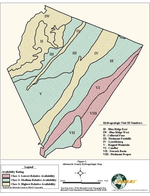
2 Table of Contents 1.0 Introduction Groundwater Availability Mapping and Classification Groundwater Sensitivity Mapping and Assessment Proposed Site-Level Groundwater Assessment Standards Recommendations for the Groundwater Management Program Available Information... 7 List of Tables Table 1 Table 2 Groundwater Sensitivity Buffers Development Criteria with Assigned Tier Rating List of Figures Figure 1 Figure 2 Albemarle County Hydrogeologic Unit Map Albemarle County Groundwater Sensitivity Map
3 1.0 Introduction This summary report provides an overview of Albemarle County s groundwater assessment efforts, particularly the phase 2 County-wide hydrogeologic assessment and the work of the Groundwater Committee. This work provides a technical foundation for the County to develop and implement groundwater policies needed to adopt the program. The County s groundwater work to date has focused on three technical areas: 1. As a long-standing Comprehensive Plan strategy, a County groundwater data base was initiated in 1998 as a pilot project for the Division of Mineral Resources (DMR). The aim of the data base was to collect historic well information from state agency records and put all the data into a GIS format. The County inherited the data base project from DMR in 2000 and completed the GIS for wells drilled through Under contract with the County, has conducted County-wide and watershed scale groundwater assessments. The phase 1 assessment (completed in April 2002) covered the Ivy Creek and Mechums River watersheds. Phase 2 completed assessment work for the entire County. The nature of this work was to explore and describe generalized groundwater conditions in the County, including the general availability and sensitivity of groundwater, utilizing the aforementioned data base, geologic and soil mapping, and other sources of information. These determinations are not designed to draw site-specific conclusions about groundwater, but to help focus what type of site-level groundwater analysis is warranted. 3. Simultaneous with ENSAT s work, the County s Groundwater Committee deliberated on the topic of appropriate site-level groundwater assessment standards for proposed development. This task was based on recommended action in the Comprehensive Plan. The Committee released its interim report, Underground Albemarle, in October Following several works session with the Planning Commission and Board of Supervisors, the committee continued to work with ENSAT to produce the recommended groundwater assessment standards, which were completed in July The County is now in a position to draw all of these efforts together into a more comprehensive groundwater program. This program would include: (1) adoption of groundwater assessment standards for proposed development, (2) development of a long-term groundwater monitoring program, and (3) the continuous updating and maintenance of the groundwater data base, relevant contaminant threats data bases (e.g., leaking underground tanks), and groundwater data from site, watershed, and County-wide studies. This summary report contains the following sections related to the phase 2 Groundwater Assessment project and the work of the Groundwater Committee: County-wide groundwater availability mapping and classification County-wide groundwater sensitivity mapping and assessment Recommended site-level groundwater assessment standards Recommendations for the groundwater management program 1
4 A detailed technical report has also been prepared that documents the project s methodology and results. The complete technical report is available from the Department of Engineering (see contact information at the end of the report). 2.0 Groundwater Availability Mapping and Classification The process of investigating groundwater availability at the County-wide scale involved identifying distinct hydrogeologic units and comparing the units based on groundwater availability characteristics for which data could be obtained. Each hydrogeologic unit shares some common characteristics with regard to geology, soils, and topography, although there is quite a bit of variability within each unit. Nine hydrogeologic units were identified across the County, as follows, and as shown on the Albemarle County Hydrogeologic Unit Map (Figure 1). 1. Blue Ridge West-IW: This unit lies primarily on the steep eastern slope of the Blue Ridge Mountain. Slopes range from 2-60%, and the soils are considered relatively deep and well drained. Rock types include volcanic greenstone and weathered granite and granite gneiss. 2. Blue Ridge East-IE: The Blue Ridge East unit overlies volcanic greenstone rock. The area is characterized by the presence of a prominent ridge that runs generally northeast within the otherwise rolling piedmont landscape. Portions of this ridge are known locally as Green Mountain, Carters Mountain, and the Southwest Mountains. 3. Colluvial Fans-II: The Colluvial Fan unit lies at the base of the eastern slopes of the Blue Ridge Mountain and is characterized by relatively steep drainage swales that extend to more gradual sloping conditions. Slopes range from 2-45%. Many of the soils in this area are transported from upslope areas through landslides and debris flows ( colluvial ) or the movement of water in drainage ways ( alluvial ). This is in contrast to most of the soils in the County, which are weathered from underlying bedrock ( residual ). 4. Piedmont Foothills-III: The Piedmont Foothills unit is characterized by rolling upland to relatively steep topography. Soils within this area are moderately deep, to deep, and generally well drained on the piedmont upland and foothills of the Blue Ridge Mountain with slopes ranging from 2-45%. Soils are formed from weathered granites and metagranites of the Blue Ridge Basement complex. 5. Lynchburg-IV: The Lynchburg unit is characterized by a narrow band that trends in a northeast direction and includes a relatively long segment of the Mechums River valley. Soils within this unit are predominantly deep to moderately deep and are well drained, with slopes ranging from 2-45%. The area is underlain primarily by the Lynchburg Formation, (or the Mechums River Formation) which consists largely of metagraywacke, meta sandstone, and graphitic schist. 6. Ragged Mountain-V: The Ragged Mountain unit is characterized by mountainous terrain located in the southwestern portion of the County and is underlain by the metagranitic rocks of the Blue Ridge Basement Complex. Slopes range from 2-60%. 2
5 7. Candler-VI: The Candler formation runs in a band near the eastern border of the County in a northeast direction. The rock types in the Candler (phyllites with some metasiltstone) tend to be less brittle and are generally more ductile than other rocks in the County, meaning that fractures can close up due to the weight of overlying material. Many of the soils are shallow and somewhat excessively drained. 8. Newark Basin-VII: The Newark Basin unit is characterized by low relief topography. The unit is underlain by the Newark Supergroup that consists of sandstones, siltstones and shales. Soils within this area are deep to moderately deep and well drained. Slopes range from 2-25%. 9. Piedmont Proper-VIII: The Piedmont Proper unit is characterized by gently rolling piedmont topography along the County s eastern border. The bedrock geology underlying the unit is mapped as Metagraywacke, quartoze schist and mélange. Soils range from shallow and somewhat excessively well drained to deep and well drained. Slopes range from 2-45%. Once the hydrogeologic units were delineated, the relative potential groundwater availability of each unit was assessed based on a model that incorporates the net effect of three interrelated variables: (1) thickness of overburden, defined as the soil and saprolite that overlie bedrock, (2) saprolite permeability, or the rate at which water can transmit through the saprolite, and (3) background fracturing, which describes the degree to which the bedrock contains water bearing features to feed wells. For each variable, the study team had to use available data from the County s groundwater data base, Albemarle County Soil Survey, and data derived from field investigations to approximate values and ratings for each hydrogeologic unit. For the purposes of this report, availability has been evaluated by reasoning associated with the following fundamental characteristics of hydrogeology in central Virginia s fractured bedrock aquifers. Precipitation infiltrates through soils and underlying saprolite (overburden) that overlie bedrock. The overburden acts in a manner similar to that of a sponge by receiving and temporarily storing water that has reached the depth of the local water table. The groundwater stored within the overburden feeds underlying fractures and secondary porosity features within bedrock that can transmit water vertically and horizontally. The borehole of a bedrock well penetrates water bearing features (fractures and secondary porosity features) within the bedrock which supply groundwater to the well. The thickness of the overburden beneath the groundwater table and the permeability characteristics associated with the overburden affect the availability of groundwater to underlying water bearing features within bedrock. Thicker saturated overburden possesses a greater potential for available groundwater storage than thinner saturated overburden. Permeability characteristics of the overburden affect the rate at which groundwater can move vertically or horizontally through the overburden. Higher permeability rates within the overburden media can potentially more readily provide groundwater supply to water bearing features than lower permeability media. Water bearing features in the bedrock (fractures) may be located directly below, in close proximity to, or thousands of feet away from the saprolite that is storing the water. The density, size, and interconnectivity of the fractures determine how much water is potentially available to a well. 3
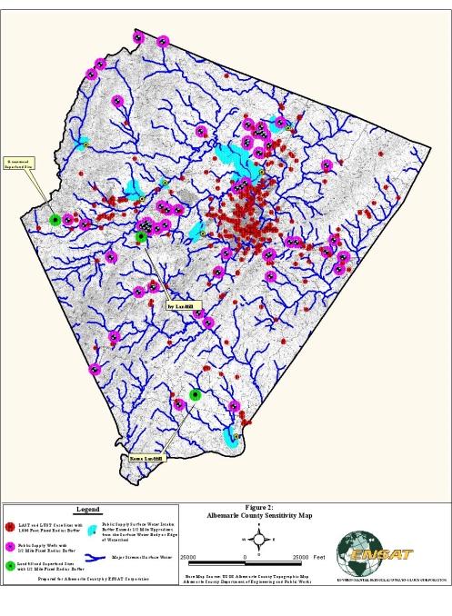
6 Based on the results of the availability model, the nine hydrogeologic units were assigned a groundwater availability classification of 1, 2, or 3, with 3 being the highest relative availability (see Map 1). It must be noted that these results are generated at a broad scale, and are meant only for County-wide planning considerations and as a way to provide focus for site-level groundwater assessments. Groundwater availability at each site is heavily dependent on sitespecific features, so the availability classifications derived from this study cannot be used to draw conclusions at the site scale. 3.0 Groundwater Sensitivity Mapping and Assessment The purpose of the groundwater sensitivity assessment was to identify, at a planning scale, areas where there are red flags with regard to groundwater quality. For the purposes of this study, groundwater sensitivity was defined by the following two categories: Source Value identified areas that are sensitive because of their proximity to an existing valuable resource, such as a public water supply intake or existing community water supply well head. The intent here was that existing and future uses should not become a threat to valuable resources. For instance, septic drainfields associated with a new development should not endanger a nearby community water supply, or new wells should not interfere with the reliability of an existing community well. Contaminant Threats identified areas that are sensitive because of their proximity to an identified threat, such as a leaking underground storage tank. With these areas, the intention was to try to prevent newly-constructed wells from becoming contaminated. In the most dramatic case, which occurred several yeas ago in Albemarle County, a newly-constructed well became contaminated almost immediately from a known contaminant plume. Contaminant threats included in the analysis were leaking petroleum storage tanks (underground and above ground), landfills, and Superfund sites. The study team conducted an inventory of source value sites and contaminant threat sites available from local and state agencies, notably, the Department of Health, Department of Environmental Quality, and Albemarle County. Once all of these sites were identified and mapped, a fixed radius buffer was assigned to each category based on a literature review of appropriate buffers from state-level wellhead protection programs across the Country. These buffer areas are identified in Table 1 and shown on the Albemarle County Groundwater Sensitivity Map (Figure 2). TABLE 1 Groundwater Sensitivity Buffers Sensitivity Area Source Value Areas Public groundwater supply wells Public supply surface water intakes Contaminant Threat Areas Leaking petroleum storage tanks (underground & above ground) Landfills & Superfund sites Assigned Buffer ½ mile fixed radius ½ mile fixed radius (upgradient drainage area) 1,000 feet fixed radius ½ mile fixed radius 4
7 It is not intended that these sensitivity buffer areas serve as conclusive zones of known sensitivity. As stated, they serve as red flags (or planning scale information) for existing and proposed land uses within the buffers. The sensitivity zones were used to help construct the sitelevel groundwater assessment standards (see below) so that proposed development within these buffers could conduct more thorough analysis to help prevent future problems. Site-specific studies can more accurately determine the nature of proposed threats and how to prevent problems through design and management measures. 4.0 Proposed Site-Level Groundwater Assessment Standards As stated, the development of the site-level groundwater assessment standards was a collaborative effort between ENSAT and the County s Groundwater Committee. ENSAT produced draft standards that underwent revisions based on Committee comments. The Board of Supervisors authorized the formation and representation of the Groundwater Committee in May, 2000 based on strategies in the Comprehensive Plan as well as several work sessions with the Planning Commission. The purpose of the Groundwater Assessment Standards is to establish protocols for proposed land uses to develop designs, plans, and monitoring to promote the long-term sustainability of groundwater resources. For this purpose, long-term sustainability means that adequate groundwater quantity and quality exists to meet the long-term needs of the proposed use without negatively impacting the quality or quantity of neighboring groundwater users. Furthermore, through design and management practices, a site can provide for its long-term water needs without resort to public water line extensions, which are costly and contrary to the County's Comprehensive Plan. To achieve these purposes, the application of the standards is intended to result in better information to make decisions. These include various decisions at different scales, including: Potential purchasers of property to determine if an adequate water supply exists, Developers and landowners who intend to create new divisions to understand the constraints and opportunities of the groundwater resource, Designers of new divisions to match design and layout to groundwater characteristics, and The County to manage, monitor, and continue to build the big-picture understanding of groundwater resources to make wise land use decisions. While the information generated from the assessment standards will not guarantee the long-term productivity and/or potability of every well, the reports will represent an effort to perform a reasonable level of diligence by evaluating the sustainability of the local groundwater supply. The standards place responsibility on applicants for various County approvals to conduct some level of groundwater assessment prior to development. The County s responsibilities and roles with this program are to administer the regulatory process, maintain all relevant base maps and data bases (e.g., groundwater sensitivity areas, well data base, etc.), manage the groundwater monitoring network, and conduct basin-scale or regional groundwater studies, as funded by the Board of Supervisors, to further understand groundwater. 5
8 The groundwater assessment standards are based on a tiered approach, whereby analysis, reporting, and testing requirements are based on the nature of the proposed land use activity and whether the proposed project lies within one of the groundwater sensitivity areas outlined in the previous section. The various tier levels of groundwater assessment are outlined in Table 2. Table 2 Development Criteria with Assigned Tier Rating Criteria Not Within Area of Identified Within Area of Identified Sensitivity Sensitivity Building Permit for New Structure Tier 1: drill well prior to BP Tier 1: drill well prior to BP Creation of any development right lot (<21 acres) Creation of 4 or more lots where at least 3 lots are 5 acres or less Commercial or industrial use using less than 500 gallons/day (average) Commercial or industrial use using > than 500 gallons/day and < 2,000 gallons/day (average) Commercial or industrial use using more than 2,000 gallons/day (average) Approval of any central water supply, as defined by Chapter 16 of the County Code Tier 2: County staff review Tier 3: groundwater management plan Tier 2: County staff review Tier 3: groundwater management plan Tier 4: groundwater management plan + testing Tier 4: groundwater management plan + testing Tier 3: groundwater management plan Tier 4: groundwater management plan + testing Tier 3: groundwater management plan Tier 4: groundwater management plan + testing Tier 4: groundwater management plan + testing Tier 4: groundwater management plan + testing A detailed description of each tier level of assessment is available in the full report or can be downloaded from the County s Water Resources web page (see information at the end of the report). 5.0 Recommendations for the Groundwater Management Program The Albemarle County Hydrogeologic Assessment project was conducted to assist in protecting the quality and quantity of groundwater in the County. Work completed within Phase II of this project has resulted in the development of tools that will assist in this cause. If adopted, the groundwater assessment standards will generate additional important information that will aid in interpreting hydrogeologic conditions at the site scale. Additional assessment and monitoring data generated from site scale assessments will provide a better understanding of the groundwater resources within the County. The protection of this most important natural resource will require a continued commitment to collect, analyze and interpret hydrogeologic data to enable both interpretation of hydrogeologic conditions and to provide an enhanced understanding the hydrogeologic framework of Albemarle County. The implementation of a long-term County Groundwater Monitoring Program is recommended to further support this cause. 6
9 Establishing a groundwater monitoring program would require analysis of existing data to culminate in the preparation of a groundwater monitoring plan. The monitoring plan would identify specific monitoring goals and would be designed to aid in preparing groundwater flow direction mapping and delineation of groundwater recharge areas. Another important component of this program will be to provide continuous updating and quality control checking of the County s well data base. The sensitivity mapping completed within this assessment will require future updating to include any new public water supply sources or potential contaminant threats. The sensitivity mapping should therefore be considered a living document. In summary, the recommendations for implementing a Groundwater Management Program are as follows: 1. Adopt the groundwater ordinance and groundwater assessment standards for proposed development. 2. Provide for the long-term updating and quality control for the well data base. 3. Gradually build a groundwater monitoring program, to incorporate monitoring wells installed with new development and other monitoring locations based on specific monitoring goals. 4. Provide for regular updating of the groundwater sensitivity map and other relevant base and GIS maps. 5. Revise and update the comprehensive plan, ordinances and design standards, as new groundwater information is available. 6.0 Available Information For a copy of the full technical report on the phase 2 groundwater assessment, contact the Department of Engineering at (434) or dhirsch@albemarle.org. To download the proposed site-level groundwater assessment ordinance and design standards, go to the County s Water Resources web page (at click on Water Resources Management under the Services menu). For questions or comments, contact David Hirschman at the phone number or address listed in the first bullet. 7
10 Figures
11
12
Water Education Foundation Briefing Water Year 2016: San Joaquin Valley Groundwater Conditions
 Groundwater in Fractured Rock Aquifers Well Location, Yield, and Sustainability Water Education Foundation Briefing Water Year 2016: San Joaquin Valley Groundwater Conditions John Kirk, PG, CEG, CHG Engineering
Prepared For: Town of Castle Valley, Utah
 HYDROLOGIC ASSESSMENT OF THE SURFACE WATER AND GROUNDWATER RESOURCES OF CASTLE VALLEY, UTAH: PART 2: HESA-BASED SITING OF CULINERY WELL FOR TOWN OF CASTLE VALLEY Authors: Dr. Kenneth E. Kolm, Hydrologic
Characteristics of Land Resources
 Chapter Chapter 1 Characteristics of Land Resources The geology, soils and topography of Woodford County T he geology, soils and topography of an area are important to the community planning process for
East Maui Watershed Partnership Adapted from Utah State University and University of Wisconsin Ground Water Project Ages 7 th -Adult
 INTRODUCTION What is groundwater? Water contained in saturated soil and rock materials below the surface of the earth. It is not NEW water, but is recycled water through the hydraulic cycle. The source
SECTION2 Drainage Control for Surface Mines. Some Technical Aspects of Open Pit Mine Dewatering
 SECTION2 Drainage Control for Surface Mines 22 Some Technical Aspects of Open Pit Mine Dewatering by V. Straskraba, Senior Mining Hydrogeologist, Dames & Moore, Denver, Colorado, USA INTRODUCTION In recent
4.0 Procedures And Layer Descriptions:
 4.0 Procedures And Layer Descriptions: The complexity of the hydrogeology in the Middle and Upper Roaring Fork study area and the disparity in type, distribution and accuracy of available data do not support
Infiltration Guidelines
 Appendix E Infiltration Guidelines As a stormwater management method, infiltration means retaining or detaining water within soils to reduce runoff. Infiltration can be a cost-effective method to manage
Montana Ground-Water Assessment Statewide Monitoring Well Network
 Montana Ground-Water Assessment Statewide Monitoring Well Network Montana Ground-Water Assessment Water-level Monitoring and Drought: January March 2004 Tom Patton - Montana Bureau of Mines and Geology
NATURAL FEATURES, LAND SUITABILITY FOR DEVELOPMENT AND DEVELOPMENT CONCERNS
 East Central Wayne County Comprehensive Plan - Natural Features, Land Suitability Page 170 NATURAL FEATURES, LAND SUITABILITY FOR DEVELOPMENT AND DEVELOPMENT CONCERNS Introduction The residents of East
SECTION 3 NATURAL RESOURCES
 SECTION 3 NATURAL RESOURCES The natural environment plays a large role in planning for future development. Environmental conditions, such as topography, wetlands, floodplains, and water bodies, can often
GROUNDWATER DISCHARGE
 GROUNDWATER DISCHARGE C O N N E C T I O N F A C T S H E E T S E R I E S D I S C H A R G E : The movement of groundwater from the subsurface to the surface P E R M E A B I L I T Y : The ability of a material
(this cover page left intentionally blank)
") 4. Siting the Well (this cover page left intentionally blank) 4. Siting the Well Chapter Table of Contents Chapter Table of Contents Chapter Description... 4 Regulatory Requirements Well Siting... 4 Relevant
4. Siting the Well (this cover page left intentionally blank) 4. Siting the Well Chapter Table of Contents Chapter Table of Contents Chapter Description... 4 Regulatory Requirements Well Siting... 4 Relevant
Using Fractran Fracture Flow Modeling in Tandem with Modflow to Assist in the Development of Wellfield Protection Zones for Municipal Wells in Bedrock
 Using Fractran Fracture Flow Modeling in Tandem with Modflow to Assist in the Development of Wellfield Protection Zones for Municipal Wells in Bedrock T.K. Wiezel 1, G.G. Violette 1 and S.T. Hamilton 2
Design Guideline for Gravity Systems in Soil Type 1. January 2009
 Design Guideline for Gravity Systems in Soil Type 1 January 2009 This page is intentionally blank. Design Guideline for Gravity Systems in Soil Type 1 January 2009 For information or additional copies
Groundwater. Groundwater Movement. Groundwater Movement Recharge: the infiltration of water into any subsurface formation.
 On March 22, 2014, a major landslide occurred near Oso, Washington. Death toll currently at 30, with 15 still missing. Groundwater Before and After Swipe http://bit.ly/pen1jt N. Fork Stillaguamish River
Montana Ground-Water Assessment Statewide Monitoring Well Network
 Montana Ground-Water Assessment Statewide Monitoring Well Network Montana Ground-Water Assessment Water-level Monitoring and Drought: January - March 2003 Tom Patton - Montana Bureau of Mines and Geology
Determining Infiltration Rates: Approaches, Challenges & Lessons Learned
 Determining Infiltration Rates: Approaches, Challenges & Lessons Learned May 16, 2017 Presented by Andrew Austreng, LHG Presentation Outline Overview of Site Characterization & Testing Pilot Infiltration
Harford County Health Department Resource Protection Division
 Harford County Health Department Resource Protection Division www.harfordcountyhealth.com Harford County Wells - Water Quantity and Quality Booklet # 02-08 Water Quantity Water sources for individual wells
NOTE ON WELL SITING AT CORNER OF CASTLE VALLEY DRIVE AND SHAFER LANE FOR TOWN OF CASTLE VALLEY, GRAND COUNTY, UTAH
 NOTE ON WELL SITING AT CORNER OF CASTLE VALLEY DRIVE AND SHAFER LANE FOR TOWN OF CASTLE VALLEY, GRAND COUNTY, UTAH Authors: Dr. Kenneth E. Kolm, Hydrologic Systems Analysis, LLC., Golden, Colorado and
Green Station CCR Surface Impoundment Sebree Generating Station Address: 9000 Highway 2096 Robards, Kentucky 42452
 Big Rivers Electric Corporation Disposal of Coal Combustion Residuals (CCR) from Electric Utilities Final Rule CCR Impoundment Groundwater Monitoring System and Statistical Methods Assessment and Certification
Overview. Students will...
 Overview Students will... Understand the interaction between ground water and surface water. Observe the difference between a permeable layer and an impermeable layer in an aquifer. See how water is stored
PIMA COUNTY COMPREHENSIVE PLAN CO PIMA COUNTY REGIONAL COMPREHENSIVE PLAN POLICY MAJOR PLAN AMENDMENT
 PIMA COUNTY COMPREHENSIVE PLAN CO7-07-04 PIMA COUNTY REGIONAL COMPREHENSIVE PLAN POLICY MAJOR PLAN AMENDMENT Arizona law [A.R.S. 11-821(C)(3)] requires: Planning for water resources that addresses: a)
HYDROGEOLOGY OF THE HUMBOLDT RIVER BASIN, IMPACTS OF OPEN-PIT MINE DEWATERING AND PIT LAKE FORMATION
 HYDROGEOLOGY OF THE HUMBOLDT RIVER BASIN, IMPACTS OF OPEN-PIT MINE DEWATERING AND PIT LAKE FORMATION June, 2015 Tom Myers, Ph.D., Hydrologic Consultant, Reno NV tom_myers@charter.net Prepared for: Progressive
Watershed: an area or ridge of land that separates waters flowing to different rivers, basins, or seas. It is the interdependent web of living
 Watershed: an area or ridge of land that separates waters flowing to different rivers, basins, or seas. It is the interdependent web of living organisms that inhabit a geographic area and depend on it
STRAWMAN OUTLINE March 21, 2008 ISWS/ISGS REPORT ON THE OPPORTUNITIES AND CHALLENGES OF MEETING WATER DEMAND IN NORTH-EAST ILLINOIS
 STRAWMAN OUTLINE March 21, 2008 ISWS/ISGS REPORT ON THE OPPORTUNITIES AND CHALLENGES OF MEETING WATER DEMAND IN NORTH-EAST ILLINOIS REPORT TO BE DELIVERED TO THE RWSPG BY SEPTEMBER 30, 2008 Table of Contents
Report created: 3/25/2009 1
 Iowa Department of Natural Resources Source Water Assessment and Protection (SWAP) Phase I Report for Dubuque (PWS#3126052) Cambrian/Ordovician Aquifer What is SWAP? The purpose of Iowa s Source Water
CHAPTER 13 OUTLINE The Hydrologic Cycle and Groundwater. Hydrologic cycle. Hydrologic cycle cont.
 CHAPTER 13 OUTLINE The Hydrologic Cycle and Groundwater Does not contain complete lecture notes. To be used to help organize lecture notes and home/test studies. Hydrologic cycle The hydrologic cycle is
Effect of the Underlying Groundwater System on the Rate of Infiltration of Stormwater Infiltration Structures.
 Effect of the Underlying Groundwater System on the Rate of Infiltration of Stormwater Infiltration Structures. Presented at: Storm Water Infiltration & Groundwater Recharge A Conference on Reducing Runoff
Karst Spring: Generalized Monitoring Strategy
 General Hydrologic Characteristics of Karst Springs Karst spring means a location of concentrated groundwater discharge from conduits in bedrock (predominantly solution enhanced conduits or zones in carbonate
POND CONSTRUCTION. Woodland Steward Series
 POND CONSTRUCTION Woodland Steward Series BOB TWOMEY DISTRICT CONSERVATIONIST USDA NATURAL RESOURCES CONSERVATION SERVICE COURSE OUTLINE DEFINITION OF A POND OR LAKE TYPES OF PONDS GEOLOGIC CONSIDERATIONS
Our Eastern Shore Groundwater Part IV Groundwater Quality on the Eastern Shore: How safe is our groundwater and are there ways we can protect it?
 Our Eastern Shore Groundwater Part IV Groundwater Quality on the Eastern Shore: How safe is our groundwater and are there ways we can protect it? Britt McMillan, Malcolm Pirnie, Inc. Mercury Venus Mars
Occurrence of Iron in Surface Waters of the Upper St. Johns River Basin
 Occurrence of Iron in Surface Waters of the Upper St. Johns River Basin Prepared by Florida Department of Environmental Protection Bureau of Watershed Management Ground Water Protection Section December
THE ABATEMENT PLAN. beneficial abatement plan. For the purpose of defining the pollution potential of surface waters
 THE ABATEMENT PLAN GENERAL PLAN Preventing surface waters from entering deep mine workings apparently offers the most beneficial abatement plan. For the purpose of defining the pollution potential of surface
AGRAR. Augmenting Groundwater Resources by Artificial Recharge. ICARDA, Aleppo, Syria nd November 2006
 AGRAR Augmenting Groundwater Resources by Artificial Recharge UNESCO G-WADI MEETING ON WATER HARVESTING ICARDA, Aleppo, Syria 20 22 nd November 2006 Project objectives BGS approached by DFID in 2000 to
Groundwater. Chapter 10 11/22/2011. I. Importance of groundwater
 Groundwater Chapter 10 I. Importance of groundwater A. Groundwater is water found in the pores of soil and sediment, plus narrow fractures in bedrock B. Where is fresh water - 2 % of all water is fresh
Groundwater Master Plan Update: Emergency Groundwater Supply Analysis & Water Quality Discussion
 Groundwater Master Plan Update: Emergency Groundwater Supply Analysis & Water Quality Discussion BPU Study Session October 4, 2012 Presentation Outline Groundwater Quality Discussion Basin Overview Groundwater
City of Cottage Grove WATER SERVICE FEASIBILITY STUDY FOR TRANSMISSION LINE CUSTOMERS FEASIBILITY REPORT FINAL. November In Association With
 City of Cottage Grove WATER SERVICE FEASIBILITY STUDY FOR TRANSMISSION LINE CUSTOMERS The undersigned has approved this document for and on behalf of Carollo Engineers, P.C. Partner FEASIBILITY REPORT
Charleville WS (BH 3)
") Water Framework Directive Groundwater Monitoring Programme Site Information Charleville WS (BH 3) ImagePath1: Charleville WS (BH 3)\04-008 (a) p.hse_(800_x_600).jpg Charleville WS (BH-3) is a borehole
Water Framework Directive Groundwater Monitoring Programme Site Information Charleville WS (BH 3) ImagePath1: Charleville WS (BH 3)\04-008 (a) p.hse_(800_x_600).jpg Charleville WS (BH-3) is a borehole
Streamlines V2, n2 (May 1997) A Newsletter for North Carolina Water Supply Watershed Administrators
 A Newsletter for North Carolina Water Supply Watershed Administrators") Page 1 of 5 STREAMLINES A Newsletter for North Carolina Water Supply Watershed Administrators Volume 2, Number 2 May 1997 Non-Point Source (NPS) Pollution This issue of Streamlines provides basic information
Page 1 of 5 STREAMLINES A Newsletter for North Carolina Water Supply Watershed Administrators Volume 2, Number 2 May 1997 Non-Point Source (NPS) Pollution This issue of Streamlines provides basic information
DEPARTMENT OF ENVIRONMENTAL QUALITY WATER QUALITY DIVISION PERMIT APPLICATION FORM UNDERGROUND INJECTION CONTROL (UIC) CLASS V WELL
 CLASS V WELL") DEPARTMENT OF ENVIRONMENTAL QUALITY WATER QUALITY DIVISION PERMIT APPLICATION FORM UNDERGROUND INJECTION CONTROL (UIC) CLASS V WELL Mail To: WDEQ/WQD ATTN: UIC Program 122 W. 25 th St. 4W Cheyenne, WY
DEPARTMENT OF ENVIRONMENTAL QUALITY WATER QUALITY DIVISION PERMIT APPLICATION FORM UNDERGROUND INJECTION CONTROL (UIC) CLASS V WELL Mail To: WDEQ/WQD ATTN: UIC Program 122 W. 25 th St. 4W Cheyenne, WY
STANDARDS AND GUIDELINES FOR MUNICIPAL WATERWORKS, WASTEWATER AND STORM DRAINAGE SYSTEMS
 STANDARDS AND GUIDELINES FOR MUNICIPAL WATERWORKS, WASTEWATER AND STORM DRAINAGE SYSTEMS January 2006 Drinking Water Branch Environmental Policy Branch Environmental Assurance Division Pub. No.: T/840
Freshwater. 260 Points Total
 9 SURFACE WATER SECTION 9.1 Surface Water Movement In your textbook, read about surface water and the way in which it moves sediment. Complete each statement. (13 points) 1. An excessive amount of water
SCOPE OF WORK (Last amendment 9/18/08) Update: Signed agreement in hand Work to proceed March 15, 2009 June 30, 2010
 Update: Signed agreement in hand Work to proceed March 15, 2009 June 30, 2010") SCOPE OF WORK (Last amendment 9/18/08) Update: Signed agreement in hand Work to proceed March 15, 2009 June 30, 2010 TITLE: IDENTIFICATION OF ILLICIT DISCHARGES TO STORM DRAIN SYSTEM PROBLEM/NEED: The
SCOPE OF WORK (Last amendment 9/18/08) Update: Signed agreement in hand Work to proceed March 15, 2009 June 30, 2010 TITLE: IDENTIFICATION OF ILLICIT DISCHARGES TO STORM DRAIN SYSTEM PROBLEM/NEED: The
Section 5 Packages. 5.1 Package Development Problem Statements A 5-1
 5.1 Package Development Each of the options presented in Section 4 was conceived to serve one or more purposes. No single option, however, is capable of addressing all of the County s water management
DEPARTMENT OF ENVIRONMENTAL RESOURCES REVIEW NOTICE
 DEPARTMENT OF ENVIRONMENTAL RESOURCES REVIEW NOTICE This report, prepared by outside consultants, has been reviewed by the Department of Environmental Resources and approved for publication. The contents
Issue paper: Aquifer Water Balance
 Issue paper: Aquifer Water Balance 1. Introduction And Background 1.1. Purpose and Scope The population in Kitsap County has grown rapidly in recent years and is expected to increase substantially in the
Potential effects evaluation of dewatering an underground mine on surface water and groundwater located in a rural area
 Potential effects evaluation of dewatering an underground mine on surface water and groundwater located in a rural area ITRODUCTIO Michel Mailloux* Eng. M.Sc, Vincent Boisvert, M.Sc, Denis Millette, Eng.,
State of West Virginia Source Water Assessment and Protection Program Source Water Assessment Report
 State of West Virginia Source Water Assessment and Protection Program Source Water Assessment Report Austin MHP Berkeley County PWSID: WV3300244 Prepared by: West Virginia Department of Health and Human
Injection Wells. An injection well is a vertical pipe in the ground into which water, other liquids, or gases are
 Injection Wells An injection well is a vertical pipe in the ground into which water, other liquids, or gases are pumped or allowed to flow. They are used for many purposes. In the 1930 s oil companies
Madison Water Utility Pressure Zone 4 Well Siting Study
 Madison Water Utility Summary of Potential Well Sites March 24 2011 Site Status Comment 1 Dairy Center In consideration Several suitable properties in this area are available. 2 Tradewinds In consideration
Stormwater Design for Karst Terrain
 Stormwater Design for Karst Terrain Key Challenges Guiding Design Philosophy Site Investigations Stormwater Hotspots Sinkholes and UIC Permits CSN Technical Bulletin No. 1 available at www.chesapeakestormwater.net
Ordinance No: County Counsel Summary
 Ordinance No: 5160 AN INTERIM URGENCY ORDINANCE OF THE COUNTY OF MONTEREY, STATE OF CALIFORNIA, TEMPORARILY PROHIBITING THE ACCEPTANCE AND PROCESSING OF WATER WELL APPLICATIONS AND ISSUANCE OF WATER WELL
THE WYOMING FRAMEWORK WATER PLAN
 THE WYOMING FRAMEWORK WATER PLAN A SUMMARY OCTOBER 2007 WYOMING WATER DEVELOPMENT COMMISSION This report was prepared by: WWC Engineering Hinckley Consulting Collins Planning Associates Greenwood Mapping,
IV. ENVIRONMENTAL IMPACT ANALYSIS G. HYDROLOGY/WATER QUALITY
 IV. ENVIRONMENTAL IMPACT ANALYSIS G. HYDROLOGY/WATER QUALITY ENVIRONMENTAL SETTING The project site is located in the Wilshire community of the City of Los Angeles and is bound by S. Wetherly Drive to
Water Resources on PEI: an overview and brief discussion of challenges
 Water Resources on PEI: an overview and brief discussion of challenges Components: Components and links Atmospheric water Surface water (including glacial water) Groundwater Links: Precipitation (atm(
Aquifer Characterization and Drought Assessment Ocheyedan River Alluvial Aquifer
 Aquifer Characterization and Drought Assessment Ocheyedan River Alluvial Aquifer Iowa Geological Survey Water Resources Investigation Report 10 Aquifer Characterization and Drought Assessment Ocheyedan
Sustainable Groundwater Management Act (SGMA) Implementation in West Placer County
 Implementation in West Placer County") Sustainable Groundwater Management Act (SGMA) Implementation in West Placer County 1 What we re covering today Background and need of Sustainable Groundwater Management Act Formation of Groundwater Sustainability
Sustainable Groundwater Management Act (SGMA) Implementation in West Placer County 1 What we re covering today Background and need of Sustainable Groundwater Management Act Formation of Groundwater Sustainability
Robert W. Buddemeier*, Hillel Rubin**, and David P. Young *
 PROTECTING URBAN WATER SUPPLIES IN SOUTH-CENTRAL KANSAS BY INTEGRATED GROUNDWATER-SURFACE WATER MANAGEMENT TO MEET MUNICIPAL, AGRICULTURAL AND ECOSYSTEM WATER NEEDS Robert W. Buddemeier*, Hillel Rubin**,
ENVIRONMENTAL HYDROGEOLOGY
 ENVIRONMENTAL HYDROGEOLOGY m LEWIS Mostafa M. Soliman Professor, Faculty of Engineering Ain Shams University Cairo, Egypt Philip E. LaMoreaux Senior Hydrogeologist Bashir A. Memon Executive Vice President
Safe Yield Study January 2004
 Safe Yield Study January 2004 Safe Yield Study Prepared For Prepared By January 2004 RIVANNA WATER AND SEWER AUTHORITY CHARLOTTESVILLE, VIRGINIA SAFE YIELD STUDY EXECUTIVE SUMMARY BACKGROUND Since 1973
Manure Management Guidelines for Limestone Bedrock/Karst Areas of Genesee County, New York: Practices for Risk Reduction
 Animal Science Publication Series No. 240 Manure Management Guidelines for Limestone Bedrock/Karst Areas of Genesee County, New York: Practices for Risk Reduction Karl Czymmek 1, Larry Geohring 2, Jacqueline
The Opportunities, Challenges, and Unknowns of Shale Gas Exploration
 The Opportunities, Challenges, and Unknowns of Shale Gas Exploration H. A L L E N K L A I B E R A S S I S T A N T P R O F E S S O R, A E D E C O N O M I C S T H E O H I O S T A T E U N I V E R S I T Y
Worksheet #8 Assessing the Risk of Groundwater Contamination from Livestock Yards Management
 Worksheet #8 Assessing the Risk of Groundwater Contamination from Livestock Yards Management Why should I be concerned? Livestock yards, such as barnyards, holding areas and feedlots, are areas of concentrated
Michigan Department of Environmental Quality Resource Management Division Office of Oil, Gas, and Minerals
 Michigan Department of Environmental Quality Resource Management Division Office of Oil, Gas, and Minerals DEQ Mission Statement The Michigan Department of Environmental Quality promotes wise management
Groundwater Earth 9th Edition Chapter 17 Mass wasting: summary in haiku form Importance of groundwater Importance of groundwater
 1 2 3 4 5 6 7 8 9 10 11 Groundwater Earth 9 th Edition Chapter 17 Geology 100 Mass wasting: summary in haiku form The grass is greener over the septic system said Erma Bombeck. Importance of groundwater
Chapter 3 Dispersion BMPs
 Chapter 3 Dispersion BMPs 3.1 BMP L611 Concentrated Flow Dispersion 3.1.1 Purpose and Definition Dispersion of concentrated flows from driveways or other pavement through a vegetated pervious area attenuates
EES 1001 Lab 9 Groundwater
 EES 1001 Lab 9 Groundwater Water that seeps into the ground, and is pulled down by gravity through void spaces (*see below) in the soil and bedrock eventually percolates down to a saturated zone, a water-logged
CITY OF HOYT LAKES, MINNESOTA SOURCE WATER ASSESSMENT
 CITY OF HOYT LAKES, MINNESOTA SOURCE WATER ASSESSMENT November 2002 Public Water Supplier ID 1690028 Facility Contact: Minnesota Department of Health Contact: Mr. Floyd Nelson, Supervisor Ms. Beth Kluthe
CITY OF MONTCLAIR Montclair Civic Center 5111 Benito Street Montclair, CA 91763
 CITY OF MONTCLAIR Montclair Civic Center 5111 Benito Street Montclair, CA 91763 I. Introduction Water Quality A National, State, and Local Concern Throughout the United States, many rivers, creeks, streams,
Background Information on the. Peace River Basin
 Background Information on the Peace River Basin Resource Conservation & Development Department August 24 Background Physiography The Peace River drainage basin occupies large parts of Polk, Hardee, DeSoto,
Groundwater utilization in Ghana
 Future Groundwater Resources at Risk (Proceedings of the Helsinki Conference, June 1994). IAHS Publ. no. 222, 1994. 149 Groundwater utilization in Ghana B. K. KORTATSI Water Resources Research Institute,
Physiographic zones. and water quality
 Southland Physiographic zones Central Plains Technical information Physiographic zones are part of the Water and Land 2020 & Beyond project that aims to maintain and improve water quality in the Southland
EAST TORRANCE SOIL AND WATER CONSERVATION DISTRICT. LONG RANGE PLAN July 1, 2009 June 30, 2019
 EAST TORRANCE SOIL AND WATER CONSERVATION DISTRICT LONG RANGE PLAN July 1, 2009 June 30, 2019 INTRODUCTION The East Torrance Soil and Water Conservation District covers 1,142,028 acres of land in Torrance
TOWNSHIP OF KINGWOOD COUNTY OF HUNTERDON STATE OF NEW JERSEY RESOLUTION NO RESOLUTION CONCERNING PENNEAST PIPELINE
 TOWNSHIP OF KINGWOOD COUNTY OF HUNTERDON STATE OF NEW JERSEY RESOLUTION NO. 2014 98 RESOLUTION CONCERNING PENNEAST PIPELINE! WHEREAS, PennEast Pipeline Company, LLC, a joint project of AGL Resources, NJR
Mitigation of the Contaminated Groundwater Plume at the West Valley Demonstration Project, New York, USA 10409
 Mitigation of the Contaminated Groundwater Plume at the West Valley Demonstration Project, New York, USA 10409 Mark S. Bellis, U. S. Department of Energy; John D. Chamberlain, Linda M. Michalczak and Cynthia
RIDDICK ASSOCIATES, P.C.
 RIDDICK ASSOCIATES, P.C. CIVIL & ENVIRONMENTAL ENGINEERS 139 LAFAYETTE AVENUE SUFFERN, NEW YORK 10901 845 357-7238 FAX 845 357-7267 NORMAN L. LINDSAY DENNIS G. LINDSAY ---------------------------- SEAN
Teacher Resources: Lesson 3: Groundwater. Lesson #3: Groundwater
 Teacher Resources: Lesson 3: Groundwater Lesson #3: Groundwater Main Ideas: Accounts (From the Water Upper Anchor V. 3) Structure of Systems: Water usually exists underground in the liquid state. Macroscopic
BUILDING A WATERSHED MODEL
 BUILDING A WATERSHED MODEL OBJECTIVES Define a watershed and describe how it functions Identify that students live in a watershed within the San Antonio River Basin TOPICS Watersheds Runoff TEKS ALIGNMENT
1. Executive Summary. Valley Branch and Trout Brook Watershed Grishma Shrestha
 1. Executive Summary Introduction This report intends to explore various environmental characteristics in the Valley Branch and Trout Brook watersheds, Washington County. The report primarily emphasizes
Determining the Likelihood of Hydraulic Connection
 W A T E R S C I E N C E S E R I E S Determining the Likelihood of Hydraulic Connection Guidance for Determining the Effect of Diversion of Groundwater on Specific Streams Version.0 No. 206-0 The Water
EALT. Groundwater. Drinking Water Program. Revised June 1995
 H EALT D I V I S I O N H Drinking Water Program Groundwater Revised June 1995 Table of Contents Introduction... 1 Groundwater Usage... 1 Developing the Conceptual Model... 2 The Hydrologic Cycle...2 Where
Earth & Space Science (Water Cycle) Grade 7 Science Grade 7 Science Start Date: November 04, 2013 End Date : November 22, 2013
 Grade 7 Science Grade 7 Science Start Date: November 04, 2013 End Date : November 22, 2013") Unit Overview Hydrologic Cycle, Thermal Energy Transfer. Content Elaborations The movement of water through the spheres of E water changes state and energy is transferred, it water transfers from the hydrosphere
Unit Overview Hydrologic Cycle, Thermal Energy Transfer. Content Elaborations The movement of water through the spheres of E water changes state and energy is transferred, it water transfers from the hydrosphere
Maitland Valley WATERSHED
 Maitland Valley WATERSHED Report Card 2018 Maitland Conservation has prepared this report card as a summary of the state of your forests, wetlands, and water resources. WHERE ARE WE? We are one of 36 Conservation
The water in the town of Fruitvale may be polluted.
 The water in the town of Fruitvale may be polluted. Goal: Gather and organize information and data Assess the information and draw conclusions How will you do this? Detective Work! Pay attention to what
TORCH LAKE TOWNSHIP WATER QUALITY ACTION PLAN
 TORCH LAKE TOWNSHIP WATER QUALITY ACTION PLAN Elk-River-Chain-of-Lakes Gaps Analysis Project The Watershed Center Grand Traverse Bay Tip of the Mitt Watershed Council Michigan Department of Natural Resources
TECHNICAL CONTENT PROPOSED STEEP SLOPE REGULATION
 1 TECHNICAL CONTENT PROPOSED STEEP SLOPE REGULATION Draft 2/08/10 (Revised 02-14-11,Revised 02-21-11, Revised 03-03-11, Revised 04-19-11, Revised 04-20-11, Revised 05-05-11, Revised 05-09-11). DEFINITIONS
State of West Virginia Source Water Assessment and Protection Program Source Water Assessment Report
 State of West Virginia Source Water Assessment and Protection Program Source Water Assessment Report Oakland PSD Hancock County PWSID: WV3301517 Prepared by: West Virginia Department of Health and Human
Depth to Bedrock. Miami Valley Land Suitability Assessment - Natural Environment Factors
 for the Valley Region Depth to Bedrock Valley Land Suitability Assessment - Natural Environment Factors What is Depth to Bedrock? According to the U.S. Department of Agriculture (USDA) depth to bedrock
WELL CAPACITY EVALUATION ANANDA VILLAGE GROUNDWATER WELLS
 WELL CAPACITY EVALUATION ANANDA VILLAGE GROUNDWATER WELLS Prepared for: Mr. Peter Goering Ananda Church of Self-Realization 14618 Tyler Foote Road #174 Nevada City, CA 95959 Prepared by: HydroSolutions
Wisconsin s Buried Treasure
 Wisconsin s Buried Treasure Kevin Masarik Center for Watershed Science and Education Through the University of Wisconsin-Extension, all Wisconsin people can access University resources and engage in lifelong
Maintaining and Improving the Health of All Minnesotans
 Protecting, Maintaining and Improving the Health of All Minnesotans 7/10/17 Stephanie Adams 12 Hwy 28 E St 2 Morris, MN 56267 Dear Stephanie: Subject: Initial Comment Letter, One Watershed One Plan Thank
Introduction. B. L. Harris, D.W. Hoffman and F. J. Mazac, Jr.*
 B-6023 TEX A Syst Rural Well Water Assessment Introduction B. L. Harris, D.W. Hoffman and F. J. Mazac, Jr.* TEX*A*Syst is a series of publications to help rural residents assess the risk of ground water
The Hydrological Cycle. Hydrological Cycle. Definition of Terms. Soils and Water, Spring Lecture 7, The Hydrological Cycle 1
 The Hydrological Cycle Water vapor helps warm up the earth Evaporation+Transpiration Chemical Spill Runoff To Oceans Water potential, atmosphere Hydrological Cycle Transpiration, T Atmospheric pool Interception
PROPER CARE OF UNUSED WELLS
 PROPER CARE OF UNUSED WELLS Protect the Ground Water... make sure you are doing your part! Arkansas Water Well Construction Commission 101 East Capitol, Suite 350 Little Rock, AR 72201 (501) 682-3900 Fax:
Technical Rules: Assessment Report. Clean Water Act, 2006
 Technical Rules: Assessment Report Clean Water Act, 2006 November 20, 2008 Amended on: December 12, 2008 (administrative amendments) November 16, 2009 (EBR Posting Number EBRO10-7573) Clean Water Act,
How Groundwater Interacts with Lakes and Streams
 How Groundwater Interacts with Lakes and Streams Ken Bradbury Wisconsin Geological and Natural History Survey University of Wisconsin-Extension AGI Critical Issues Webinar July 13, 2015 Groundwater basics
LAB 11: GROUNDWATER PROCESSES AND WATER RESOURCES
 Environmental Geology 103L team Fall 2015 names LAB 11: GROUNDWATER PROCESSES AND WATER RESOURCES The objectives of this lab are to: Understand the relationship between sedimentary rock types and groundwater
DHI Sverige AB, Honnörsgatan 16, P.O. Box 3289, SE Växjö, Sweden, 3
 Hydrological and Hydrogeological Effects of a Deep-Rock Repository for Spent Nuclear Fuel in Sweden: Application of a New Coupling Routine between MIKE SHE and MOUSE Erik MÅRTENSSON 1, Lars-Göran GUSTAFSSON
State of West Virginia Source Water Assessment and Protection Program Source Water Assessment Report
 State of West Virginia Source Water Assessment and Protection Program Source Water Assessment Report Beckley Water Company Raleigh County PWSID: WV3304104 Prepared by: West Virginia Department of Health
Collect, compile, and evaluate existing studies and data; Review the projected irrigation water demand estimates;
 V. Capacity Impacts A. GROUNDWATER RESOURCES 1. Environmental Issue This section was prepared by Fugro-West and Firma, with assistance from Balance Hydrologics. The EIR groundwater investigations related