Credit River Watershed Natural Heritage System Phase 3: Natural Heritage System methodology Draft summary report, May 2014
|
|
|
- Rodger Hodge
- 6 years ago
- Views:
Transcription


1
2 Citation: CVC (Credit Valley Conservation) Credit Valley Conservation Natural Heritage System Strategy. Phase 3: Credit River Watershed Natural Heritage System.. 79p. For further inquiries regarding this report please contact: Dr. Aviva Patel Credit Valley Conservation 1255 Old Derry Road Mississauga, Ontario L5N 6R4 ii
3 Acknowledgements Credit Valley Conservation (CVC) thanks all those who have contributed to this report. Specifically, CVC would like to acknowledge past and present members of the Technical Advisory Committee, the Municipal Advisory Committee, technical peer reviewers, Internal Steering Committee and CVC staff for their contributions to the report. CVC would also like to thank the many external stakeholders and partners who took the time to provide feedback on this project. Finally CVC would like to acknowledge North-South Environmental Inc. and Halton Region for the concept of Centres of Biodiversity. The authors of this report would particularly like to thank the CVC core development team particularly Scott Sampson, Liam Marray and Yvette Roy for their dedication to this project. Their input greatly helped in developing the Credit River Watershed Natural Heritage System. Municipal Advisory Committee Ministry of Energy and Infrastructure Ministry of Natural Resources Ministry of Municipal Affairs and Housing Halton Region Region of Peel County of Dufferin County of Wellington City of Brampton City of Mississauga City of Mississauga City of Oakville Town of Caledon Town of Erin Town of Halton Hills Town of Mono Town of Orangeville Township of Amaranth/East Garafraxa Credit Valley Conservation Technical Advisory Committee Environment Canada Fisheries and Oceans Canada Ministry of Natural Resources Natural Heritage Information Centre Niagara Escarpment Commission Grand River Conservation Authority Halton Region Conservation Authority Nottawasaga Valley Conservation Authority Toronto and Region Conservation Authority Credit Valley Conservation iii
4 Executive Summary Credit Valley Conservation (CVC) is undertaking a project in four phases to develop a Natural Heritage System Strategy for the Credit River watershed: Phases 1 and 2: Characterize and assess existing conditions for the watershed in GIS, based on existing terrestrial and hydrologic data. Research ways to integrate land and water functions in a natural heritage system. Consult with stakeholders on Phases 1 and 2. Phase 3: Develop methodology for identifying a Credit River Watershed Natural Heritage System (CRWNHS, abbreviated to NHS) integrating terrestrial and aquatic components and incorporating climate change science as appropriate. Consult with project partners on system design. Phase 4: Develop recommendations for implementation of the NHS including consideration of stakeholder comments through consultation. Ongoing after Phase 4: Use the NHS to highlight the watershed importance of existing natural heritage features being protected by municipalities. Provide information to assist in updating existing municipal natural heritage system strategies within the context of watershed health. Implement the Natural Heritage System Strategy through CVC watershed management programs such as Greenlands Securement Strategy and the Integrated Watershed Restoration Strategy; through restoration, stewardship, and education activities with interested landowners; through continued inventory or monitoring of important watershed features and functions; and through CVC s advisory role in municipal natural heritage planning. Monitor and refine the NHS at appropriate time intervals, and update as required to integrate with provincial policies, Official Plans, and new science. Credit Valley Conservation has utilized its extensive natural heritage data and expertise to identify a science-based, integrated, Credit River Watershed Natural Heritage System for the CVC jurisdiction as Phase 3 of the CVC Natural Heritage System Strategy. This summary report provides an overview of the methodology for the identification of the NHS. A systems approach was used to develop the NHS, recognizing the long term ecological and human health and well-being benefits that arise from ecosystems that are healthy, connected, and resilient. The primary goals for the NHS are to protect, restore, or enhance the ecological integrity of the Credit River watershed s natural features, functions and systems; and to protect or enhance the quantity and quality of surface and ground water for environmental and human uses. A watershed is recognized by the province of Ontario as the ecologically meaningful scale for planning to protect, improve, or restore the quality and quantity of water; hence the CVC focus on the watershed as the scale for natural heritage system planning. iv
5 The NHS can be used as a watershed planning and management tool and to guide watershed securement, stewardship and restoration programs. It can also be used to identify natural heritage data gaps and to guide species or community inventories. The NHS is intended to be provided to municipal planning authorities in an advisory capacity to review existing natural heritage systems policies and strategies at the municipal scale and to enhance the protection and restoration of natural heritage features and functions within their area of jurisdiction over the long term. The NHS is not intended to limit the ability of municipalities to develop their own science-based natural heritage systems using systems approaches within their own land cover and land use context. The components of the NHS consist of natural heritage features, buffers on these features, and natural heritage areas. The system includes natural or naturalizing ecological communities as defined by the provincial Ecological Land Classification, aquatic features consisting of watercourses and water bodies, and lands such as agriculture, manicured open space, or urban which are associated with and contribute to the form and function of the NHS. The criteria for the system components and thresholds for criteria were based on well-established scientific principles, federal or provincial guidelines such as the Natural Heritage Reference Manual, best practices, professional judgment of technical committees or external peer reviewers, and CVC data. Credit River Watershed Natural Heritage System components: Natural heritage features Valleylands High Functioning and Supporting Wetlands - High Functioning and Supporting Woodlands High Functioning and Supporting Aquatic habitat - High Functioning and Supporting Lake Ontario shoreline High Functioning Significant wildlife habitat High Functioning Habitat of endangered species and threatened species High Functioning Buffers Buffers around natural heritage features to protect the features and their functions from adjoining land uses Natural heritage areas Centres for Biodiversity Natural heritage features The Natural heritage features component includes ecological features in the Credit River watershed that collectively are important for maintenance of biodiversity and ecological function in the watershed. v
6 Natural heritage features included in the NHS consist of valleylands, wetlands, woodlands, aquatic habitat and the Lake Ontario shoreline, significant wildlife habitat and habitat of endangered species and threatened species. Natural heritage features are classified into three major categories to reflect relative differences in function at the watershed scale: High Functioning, Supporting, and Contributing. High Functioning features High Functioning natural heritage features represent key natural heritage features from a watershed and/or provincial perspective that are essential for maintaining biodiversity and ecological function within the watershed over the long term. Collectively these features are essential for ensuring the integrity and resilience of the NHS. Cumulative impacts to these features are likely to have a significant impact on the resilience and self-sustainability of the NHS. Supporting features Supporting features enhance the quality and function of High Functioning features and collectively are highly likely to improve the resilience of the NHS. These features contribute to meeting science-based and federal guidelines for overall natural cover within the watershed, help maintain the abundance of common species in the landscape, and provide stepping stone habitat or tableland linkages in the landscape, improving connectivity and supporting species as they move across the landscape. The cumulative loss of these features will have some impact on overall levels of natural cover in the watershed. Contributing features Contributing features are features that play a contributing role within the watershed. These features may contribute to connectivity across the landscape but are typically very small and may also be relatively isolated from other natural heritage features. In urban areas they may be especially valued for their social function. Contributing features are not included in the NHS but sometimes are included within the system as part of a feature or area (for example, a small woodland located in the floodplain of the Credit River would also be classified as a valleyland natural heritage feature; or a small wetland located in a natural heritage area such as a Centre for Biodiversity would also be classified as a natural heritage area). Many natural heritage features have multiple roles and functions. For example, treed wetlands or swamps meet the definition of both woodlands and wetlands; and wetlands may also function as aquatic habitat. A natural heritage feature may also fall under two different relative importance categories (for example, a treed swamp may classify as a Supporting woodland but also as a High Functioning wetland, based on ecological criteria for inclusion in the NHS). In such cases, it is recognized that the feature provides multiple functions and that vi
7 management, restoration or protection of the feature should consider all the functions provided by the feature. Buffers Buffers represent minimum areas that protect natural heritage features and functions in the NHS from existing or future land uses adjoining these features. The NHS includes identification of minimum buffer widths around specific valleylands, wetlands, woodlands and aquatic habitat to protect these features and their functions from potential negative ecological impacts from existing or potential new adjoining land uses. Each natural heritage feature needs to be further evaluated on site to determine its function and sensitivity in order to evaluate appropriate buffer width and composition. Natural heritage areas Centres for Biodiversity Centres for Biodiversity are defined for the purposes of the NHS as landscapes with a concentration of natural heritage features representative of physiographic regions in the watershed, which collectively represent important ecological features and functions capable of supporting native biodiversity over the long term. Centres for Biodiversity are landscapes that contain the best representative aggregations of natural features such as woodlands, wetlands, aquatic habitat or open country habitat associated with the watershed s major physiographic regions, one inland lake and one estuarine area in the Credit River watershed. Centres for Biodiversity may contain several natural heritage features such as valleylands, wetlands, woodlands, aquatic habitat, and the Lake Ontario shoreline. They may also contain other habitat contributing to diversity or connectivity of ecosystems on the landscape, such as tableland successional or other natural habitat, agriculture, open space, or urban land use. All components of the NHS cannot be mapped. While every effort has been made to ensure data quality and currency, some minor mapping errors may exist and will be corrected as appropriate. In addition, features may change over time or field verification may alter mapping. Therefore the intent is that the text of the criteria for identifying the NHS supersedes the mapping. The total mapped area of the NHS is 46,839 ha and includes the area of Lake Ontario. When the area of the lake is excluded, the mapped NHS occupies 41% of watershed area, with 30% occupied by natural or naturalizing cover and 11% occupied by other land uses such as agriculture, open space, or urban. The development of the NHS is consistent with provincial guidance (e.g. the Natural Heritage Reference Manual) and best available science. Many of the vii
8 components of the NHS are compatible with existing planning policies and various regulations (e.g. the Conservation Authorities Act). Although the system was developed using an ecological approach, comparative analyses showed that many of the features and areas are also already designated under provincial legislation (e.g. Greenbelt Plan) or in municipal Official Plans. The development of the NHS does not limit the ability of planning authorities within CVC jurisdiction to consider other natural heritage systems approaches but provides a tool based on ecological and hydrological considerations within the Credit River watershed land use and land cover context. In this regard, CVC continues to be committed to further working with planning authorities to develop municipal level natural heritage systems that best fit their needs. Where municipalities have existing natural heritage systems, the NHS provides additional science and data and a watershed context to support these municipal systems and to help refine them as opportunities arise. Future work in Phase 4 will focus on strategies for implementation of the NHS. The system will be examined in the context of future potential land use changes and recommendations will be provided relating to protection, land securement, restoration, and stewardship. viii
9 Table of Contents 1. Credit Valley Conservation Natural Heritage System Strategy Systems approach to natural heritage planning in Ontario Natural heritage systems planning to achieve ecosystem benefits and resilience Guiding principles, goals and objectives for the NHS Targets inform development and implementation of the NHS Physiography and natural cover in the Credit River watershed inform natural heritage systems planning Development of the NHS Natural heritage features Buffers on natural heritage features Natural heritage areas Credit River Watershed Natural Heritage System Relating the NHS to a PPS framework Connectivity within the system and to adjoining natural heritage systems and features Assessment of the NHS against targets and existing conditions Next steps Glossary Literature cited List of figures Figure 1. Land cover and land use in the Credit River watershed and its three physiographic zones Figure 2. Physiographic regions, physiographic zones, and Northern and Southern zones of the Credit River watershed in relation to the Ecodistrict boundaries and the Greenbelt boundary Figure 3. Schematic showing the Credit River Watershed Natural Heritage System and its components Figure 4. High Functioning and Supporting valleylands of the NHS, mapped with associated watercourses Figure 5. High Functioning and Supporting wetlands of the NHS Figure 6. High Functioning and Supporting woodlands of the NHS Figure 7. Aquatic habitat and the Lake Ontario shoreline in the NHS Figure 8. A section of a Centre for Biodiversity, a natural heritage area, showing natural heritage features as well as other land cover and land use included within it (left) and an air photo of the same area (right) Figure 9. Centres for Biodiversity in the NHS, shown with valleyland linkages Figure 10. Mapped Credit River Watershed Natural Heritage System ix
10 List of tables Table 1. CVC targets that informed natural heritage system development Table 2. Components of the NHS Table 3. Components of the NHS with criteria, thresholds and categories Table 4. Ranges of buffer widths to natural heritage features based on current science (from Beacon Environmental Limited 2012) Table 5. Statistics relating to the mapped NHS Table 6. A comparison of some provincially designated features and areas and the mapped NHS boundary Table 7. Comparison of features and areas of the Provincial Policy Statement and of the NHS Table 8. Ecological assessment of NHS with CVC watershed targets for natural cover x
11 HOW TO READ THIS REPORT The following is a summary report on the development of the Credit River Watershed Natural Heritage System, and is a companion to the full technical report: CVC (Credit Valley Conservation) Credit Valley Conservation Natural Heritage System Strategy. Phase 3: Credit River Watershed Natural Heritage System. Draft technical report, May p. This report is intended to provide stakeholders with a higher level overview of the NHS methodology including criteria and key results. When applying the NHS it is recommended that the full technical report is consulted in its entirety. In addition, the full technical report contains detailed background literature in developing the criteria for the NHS, additional results and mapping, and appendices. xi
12 1. Credit Valley Conservation Natural Heritage System Strategy Human health is tightly linked to the health of the natural environment. Healthy ecosystems are adaptable, resilient, self-sustaining, and support diverse native flora and fauna and associated ecological functions. Functions provided by ecosystems include provision of habitat for wildlife and regulation of water, climate, gases, nutrients and disturbance. Ecosystems are also valued for the services or benefits they provide that are essential for human health and well-being such as flood moderation, water purification, waste and pollutant mitigation, temperature moderation, erosion prevention, soil formation, crop pollination, biological pest control, aesthetics and recreation. Ecosystems also provide goods such as water, food, raw materials, genetic resources, and models for design and engineering (biomimicry). In 2006 Credit Valley Conservation (CVC) recognized the need to develop a Natural Heritage System Strategy, and the CVC Board of Directors approved the Terms of Reference for the Terrestrial Ecosystem Enhancement Model (TEEM) project, now renamed with more standard terminology as the CVC Natural Heritage System Strategy. The goal of this project was to establish a natural heritage system for the Credit River jurisdiction (referred to in this report as the Credit River watershed) and implementation recommendations that would protect biodiversity and ecosystem functions of the watershed in perpetuity. Phase 1: Characterize and assess existing conditions for the watershed in GIS, based on existing terrestrial and hydrologic data. Use this Landscape Scale Analysis to assess and rank existing natural cover in terms of its watershed importance. Phase 2: Gather data and conduct research as needed to develop a natural heritage system that integrates aquatic and terrestrial functions. Consult with stakeholders on Phase 1 and 2. Phase 3: Develop methodology for identifying a Credit River Watershed Natural Heritage System (CRWNHS, abbreviated to NHS) integrating terrestrial and aquatic components. Prepare data layers for input into the NHS. Conduct quality assurance and quality control on data prior to mapping. Ensure that the NHS captures the best of CVC s existing natural cover and adds other lands to improve connectivity and resilience. Incorporate climate change science where possible in the natural heritage system design. Consult with stakeholders including neighbouring conservation authorities and municipal planning staff, and conduct technical peer review of NHS methodology. Phase 4: Develop recommendations for implementation of the NHS including consideration of stakeholder comments through consultation. Ongoing after Phase 4: Implement the NHS in official plans by engaging municipal partners, plan input and plan review. Use the NHS to highlight the watershed importance of existing natural heritage features being Credit Valley Conservation 1
13 protected by municipalities. Provide information to assist in updating existing natural heritage system protection strategies within the context of watershed health. Implement the CVC Natural Heritage System Strategy through CVC watershed management programs such as Greenlands Securement Strategy and the Integrated Watershed Restoration Strategy; through restoration, stewardship, and education activities with interested landowners; through continued inventory or monitoring of important watershed features and functions; and through CVC s advisory role in municipal natural heritage planning. Monitor and refine the NHS at appropriate time intervals, and update as required to integrate with provincial policies, Official Plans, and new science. Natural heritage system means a system made up of natural heritage features and areas, and linkages intended to provide connectivity (at the regional or site level) and support natural processes which are necessary to maintain biological and geological diversity, natural functions, viable populations of indigenous species, and ecosystems. These systems can include natural heritage features and areas, federal and provincial parks and conservation reserves, other natural heritage features, lands that have been restored or have the potential to be restored to a natural state, areas that support hydrologic functions, and working landscapes that enable ecological functions to continue. The Province has a recommended approach for identifying natural heritage systems, but municipal approaches that achieve or exceed the same objective may also be used. Provincial Policy Statement (OMMAH 2014) The NHS was designed to have the following attributes to the extent feasible with consideration for the urban and agricultural context of the watershed: Resilient to disturbance; a resilient natural heritage system is cost effective in that it is better able to sustain itself; Recognized for its value in contributing to human health, well-being, and safety; and Efficient in its use of the land base; the configuration of the NHS is optimized to perform multiple functions simultaneously. The NHS can or will be used in several ways: Provides an integrated system of terrestrial and aquatic features and functions to enable better management of the watershed s natural resources; Enables CVC to provide consistent and efficient plan input and plan review on provincial, regional, or area municipal initiatives as part of its technical advisory role, using a common NHS across the watershed; Supports CVC s Strategic Plan and existing watershed management programs such as the Greenlands Securement Strategy, the Credit River Fisheries Management Plan, the Credit River Water Management Strategy, the Lake Ontario Integrated Shoreline Strategy, and current and future programs, including subwatershed studies and a watershed plan; and Credit Valley Conservation 2
14 Provides partners, including municipalities and the province with a science-based natural heritage system based on ecological and hydrologic principles within a watershed ecosystem context and extensive data. The resulting NHS can be used to help defend and refine existing municipal natural heritage systems, or can be adapted for development of municipal level natural heritage systems in municipalities that currently lack such systems. The NHS is not intended to limit the ability of municipalities to develop their own science-based natural heritage systems using systems approaches within their own land cover and land use context. Ultimately, implementation of the NHS to achieve improved watershed benefits is everyone s responsibility. Credit Valley Conservation has multiple roles that relate to the design and implementation of the NHS, including technical and scientific advisors, land managers and stewards, regulators (regulatory role), and educators. Credit Valley Conservation also has strong partnerships with the Ontario Ministry of Natural Resources and Fisheries and Oceans Canada (DFO). Municipalities define science-based local natural heritage systems based on their data and existing land use context, develop policy, and also plan for parks and maintain the urban forest. Non-profit organizations and volunteers implement beneficial restoration and outreach initiatives. Local residents, landowners, and businesses play an important role in implementation because much of the watershed s land base is privately owned (e.g. sustainable development practices such as permeable paving and green roofs, or maintenance and enhancement of existing natural areas on properties). A collaborative approach among all stakeholders will help alleviate the impacts of stressors such as climate change, and ensure the long-term provision of ecosystem goods and services to those who live, work and play in the watershed. Phase 3 of the CVC Natural Heritage System Strategy focuses on the watershed scale development of a natural heritage system for the Credit River watershed. This report is a summary report of the main technical report titled CVC Natural Heritage System Strategy. Phase 3: Credit River Watershed Natural Heritage System that details the methodology used to develop the NHS. 2. Systems approach to natural heritage planning in Ontario Environmental planning in Ontario in the 1970s and 1980s included the identification by the province of natural heritage features for protection, such as Life Science Areas of Natural and Scientific Interest (or ANSIs). Conservation authorities also identified natural heritage features that were of high biodiversity or hydrological value, or contained aesthetic or distinctive landform characteristics; these were termed Environmentally Significant (or Sensitive) Areas (ESAs; Ecologistics Ltd. 1979). This was in response to the request of municipalities for a more comprehensive approach to conservation to promote Credit Valley Conservation 3
15 predictability in review of development plans. In 1991, the Province introduced the concept of protecting natural cores and corridors, moving beyond islands of green and into natural systems conservation (OMNR 1991). Provincial Policy direction followed, and in 1996 (OMMAH 1996), the Provincial Policy Statement (PPS) was released to provide direction on matters of provincial interest related to land use planning and development. The PPS (OMMAH 2014) contains natural heritage policies that provide protection for key natural heritage features, while stressing that the diversity and functions of natural features be maintained and that connectivity of natural features in an area should be maintained, restored, or, where possible, improved. The Provincial Policy Statement was next released in 2005 and again in Both documents emphasize the importance of recognizing linkages between and among natural features to maintain, restore or, where possible improve diversity, connectivity, long term ecological function and biodiversity of the natural heritage system. The 2014 PPS provides stronger support for a systems approach by requiring (rather than recommending as in the 2005 version) the development of natural heritage systems, although it is acknowledged that the size and form of these systems may differ among settlement areas, rural areas, and prime agricultural areas. The rationale for developing watershed based natural heritage systems is stated in a number of other provincial and federal policies, plans, and legislation including the Conservation Authorities Act (CAA 1990, Sections 21 and 28) which speak to the powers of conservation authorities to determine programs to conserve, restore, develop and manage the natural resources of the watershed and to prohibit or regulate development if the conservation of land may be affected by the development. The direction provided by the provincial government to municipalities and conservation authorities has resulted in the development of several watershed and municipal natural heritage systems in Ontario (e.g. UTRCA 2003, OMNR 2005, UTRCA and County of Oxford 2006, TRCA 2007, North-South Environmental Inc. 2009). In addition to the PPS, the importance of natural heritage planning is also identified in a number of other federal and provincial policies and plans and is covered in greater detail elsewhere (CVC 2010, 2011). A systems approach to natural heritage planning includes the development or refinement of natural heritage systems at different scales. At the provincial scale, the province of Ontario has designed connected systems (e.g. Greenbelt Natural Heritage System for the Protected Countryside, Oak Ridges Moraine Conservation Plan). At the watershed scale, conservation authorities have designed natural heritage systems to protect or enhance water quality and quantity and watershed scale ecosystem benefits. Subwatershed scale or local scale plans (e.g. area municipal natural heritage systems or Secondary plans) may further refine watershed natural heritage systems to achieve local objectives Credit Valley Conservation 4
16 for biodiversity, ecological function, and benefits to local communities. Integrating watershed based systems with regional or provincial systems results in long term resilience of natural features and functions, because ecosystems and flows of energy, material and water transcend political boundaries. Provincial areas and plans such as the Greenbelt, the Niagara Escarpment Plan and the Oak Ridges Moraine Conservation Plan cross watershed boundaries and consequently integrate different watershed based natural heritage systems. At local scales, the NHS can integrate subwatershed or local scale systems to achieve watershed or municipal objectives for natural cover, water quality and water quantity. The value of designing systems at different scales, and the shared objectives of healthy, resilient ecosystem functioning across scales, allows for efficient and optimal land use planning at each scale. 3. Natural heritage systems planning to achieve ecosystem benefits and resilience Natural areas, or ecosystems, within the Credit River watershed are critical for provision of ecosystem goods and services to local residents. Examples include (but are not limited to) flood control, groundwater recharge, climate moderation, pollination, waste management, erosion and sediment control (Costanza et al. 1997, Daily 1997, de Groot et al. 2002). Further, natural ecosystems provide habitat for native plants and animals, and provide a variety of recreational, cultural and educational values. A study commissioned by CVC estimated that the Credit River watershed provides a minimum of $371 million in ecological services annually to area residents (Kennedy and Wilson 2009). The continued provision of ecosystem services over the long term occurs when ecosystems are resilient and self-sustaining. Ecosystems are generally resilient because they contain feedback mechanisms that allow them to function in one or more stable states. However, excessive human disturbance can flip an ecosystem from one state into another state (e.g. woodland to thicket). The impact on humans when ecosystems flip into other states can be severe, and include loss of key ecosystem goods and services, impacts on human health, safety or well-being, and increase in system maintenance costs. For example, conversion of woodlands to scrub habitat may increase flooding and erosion, result in greater numbers of hazard trees, cause algal growth in streams, increase local temperatures and the heat island effect, and increase costs of restoration and mitigation. An important goal of natural heritage systems design is therefore to improve the resilience of ecosystems by mitigating the effects of human activities that create stresses on these ecosystems. Primary stressors on ecosystems in the Credit River watershed include: Land use change (from natural to agriculture or logging in the 1800s and early 1900s, and then from agriculture to urban in more recent decades), resulting in habitat loss, habitat fragmentation and/or habitat degradation; Credit Valley Conservation 5
17 Pathogens, pests and invasive species; and Climate change. Credit River Watershed Natural Heritage System Development of a NHS based on current science and landscape ecology principles can help lessen the impacts of these stresses on the watershed s ecosystems. Principles such as habitat size, connectivity, diversity and representation are incorporated into natural heritage system design to help mitigate stresses on sensitive or important ecological features and functions, as well as improve the resilience of ecosystems. When the valuable ecosystem services provided by the watershed s natural areas are compromised, the lost value must ultimately be borne by taxpayers. Maintaining and restoring a resilient, self-sustaining natural heritage system is a precautionary approach that reduces the risk of impaired ecological services and is more cost-effective than addressing problems after ecosystem services are lost. 4. Guiding principles, goals and objectives for the NHS 4.1 Guiding principles The following are CVC s guiding principles as outlined in its Strategic Plan (CVC 2006). These principles have guided development of the NHS methodology and provided a context for the development of the vision, goals and objectives for the NHS. Recognize that healthy communities require healthy ecosystems, while acknowledging the presence of other land uses in the watershed; Maintain a watershed scale perspective and consider the implications of cumulative actions on the watershed as a whole; Recognize that protection of existing natural heritage is preferable to [and more cost-effective than] restoration; Take a preventive, proactive and integrative approach and apply the Precautionary Principle to watershed management based on adaptive environmental management. The Precautionary Principle recognizes that the absence of full scientific certainty shall not be used as a reason to postpone decisions where there is a risk of serious or irreversible harm; Make decisions and take actions based on our accumulated and emerging knowledge, skills and experience. We work to continually improve our understanding of the watershed and how it functions; Subscribe to the belief that protection and restoration of watershed health is a broadly shared responsibility. We implement watershed management by working with partners and engage clients around shared interests and objectives. We strive for excellence in those relationships; Credit Valley Conservation 6
18 Pursue practical approaches to the management of water, other natural resources and natural heritage based on the application of sound science, creativity and innovation; Promote ecologically sustainable development and practices within urban and rural communities; and Contribute to climate change mitigation and adaptation in the Credit River watershed. In addition, CVC has taken into account the ecological principles established by the South Central Ontario Conservation Authorities (SCOCA) Natural Heritage Discussion Group relating to natural heritage systems design (SCOCA 2002): Approach: The Precautionary Principle should be applied in natural heritage planning; Scale: Ensure compatibility or integration of natural heritage systems across spatial scales; Cover/distribution: In general, greater amounts and more even distribution of natural cover ensure that ecological functions occur across the landscape; Size: Larger patches in an area are generally preferable to smaller ones; Shape: In fragmented landscapes, compact patch shapes are more beneficial for ecosystem function than more convoluted shapes; Matrix: the type of land use surrounding a natural heritage feature has an impact on its ecological functioning; Connectivity: Connectivity is important to maintain species functions and life cycles; and Quality/biodiversity: Quality and representation of natural heritage features, and conservation and restoration of native biodiversity are important considerations in natural heritage planning. 4.2 Goals and Objectives The goals and objectives for NHS arise from a vision of An environmentally healthy watershed supporting native biodiversity and self-sustaining natural features and functions. Goals and objectives from CVC s Strategic Plan (CVC 2006) related specifically to the maintenance of biodiversity and healthy ecosystem functioning were used to inform the following goals and objectives for the NHS Terrestrial and aquatic species, communities and ecosystems Goal: To protect, restore, or enhance the ecological integrity of the Credit River watershed s natural features, functions and systems. Objectives: a. Protect, restore and enhance integrity of watershed ecosystems, through an integrated network of natural areas, connections, and linkages; Credit Valley Conservation 7
19 b. Protect, restore and enhance native terrestrial and aquatic plant and animal species, community diversity and productivity; c. Ensure that the complete range of representative and significant natural features and functions distributed within the watershed are protected in perpetuity; d. Protect, restore and enhance natural ecosystems to sustain watershed functions, human uses, and build resilience to stresses such as climate change; and e. Promote sustainable resource management of aquatic and terrestrial systems and areas within the watershed for plant, animal and human needs Water quality and quantity Goal: To protect and enhance the quantity and quality of surface and ground water for environmental and human uses. Objectives: a. Preserve, maintain and re-establish the natural hydrological cycle; b. Maintain, enhance and restore natural stream processes to achieve a balance of flow and sediment transport; c. Maintain and restore groundwater levels and baseflows (groundwater discharge to streams) to sustain watershed functions and human uses and build resilience to stresses such as climate change; d. Minimize risk to human life and property due to flooding and erosion; e. Maintain and enhance water and sediment quality to achieve ecological integrity; f. Protect and restore surface water quality with respect to conventional and toxic pollutants to ensure protection of ecosystem functions and water supply; g. Protect, restore and enhance groundwater quality to support watershed functions; and h. Improve water quality in streams, the Credit River, and Lake Ontario Natural Hazards Goal: To protect public safety and minimize property damage from natural hazards including flooding, drought, erosion, sedimentation, wetlands and dynamic beach processes. Objectives: a. Protect potentially hazardous river or stream valleys, flood plains and Lake Ontario shoreline; and b. Protect watercourses (including their meander belt) and wetlands. Credit Valley Conservation 8
20 4.2.4 Social and Economic Goal: To promote the health and sustainability of watershed communities through effective watershed management. Objectives: a. Promote the community benefits of the watershed s natural areas and system (recreational, educational, cultural, psychological, tourism, economic); b. Recognize the contribution of the matrix, i.e. other land cover and land uses such as the urban forest to the health of the watershed s natural areas and to the well-being of watershed communities. c. Promote and engage in partnerships with agencies, municipalities, landowners and others to protect, enhance, and restore the health of the watershed s features and functions. The NHS incorporates a systems approach, namely that the health of natural heritage features depends upon their placement within a functioning system. It is also recognized that climate change has the potential to alter the features and functions within the NHS. Maintaining system resilience and minimizing or mitigating other negative impacts on natural features and functions will form an important part of CVC s adaptation strategy for climate change. The objectives of the NHS are associated with measurable targets in the following section. The above objectives will likely come closer to being achieved if the targets in the following section are met. The principles, goals and objectives of the NHS (from CVC s Strategic Plan) are also consistent with those of the Credit River Fisheries Management Plan, thereby facilitating incorporation of specific aquatic natural heritage features into the NHS. 5. Targets inform development and implementation of the NHS Targets and thresholds can provide useful guidance for natural heritage planning and securement, stewardship and restoration prioritization. Credit Valley Conservation has developed and refined targets for terrestrial and aquatic systems that are recommended for achieving water quality and quantity objectives and improved functioning and self-sustainability of ecosystems (CVC 2007 and refined in subsequent subwatershed studies). Existing CVC targets, scientific literature and existing guidelines (e.g. Environment Canada 2013) were reviewed to develop targets relevant for the Credit River watershed (Table 1). The NHS is designed to bring the watershed closer to achieving the desired targets. Supporting literature for target development is detailed further in the full Phase 3 report (CVC 2014). The watershed targets have helped to guide thresholds for criteria in the NHS. Credit Valley Conservation 9
21 Table 1. CVC targets that informed natural heritage system development. Parameter: measure Target Existing conditions Forest cover: Percent woodland cover in watershed Watershed woodland cover is currently 24% Forest interior: Percent of woodland interior (woodland cover 100 m from forest edge) in watershed Patch size: Area of large woodland patches Wetland cover: Percent wetland cover in watersheds and sub-watersheds Riparian cover 1: Width of riparian cover on streams Riparian cover 2: Percent of stream length under natural cover Watershed woodland cover target is minimum 30% (high risk for declines in species and aquatic health) with a preferred target of 40% (moderate risk for declines in species and aquatic health) Watershed woodland interior target is 10% or greater; maintain, enhance and restore existing woodland interior Watershed target is at least one, and preferably several, 200 ha woodland patches Watershed wetland cover target is 10.4%; subwatershed target is minimum 6% of each subwatershed or 40% of historic wetland coverage Watershed riparian cover target is minimum 30 m natural cover on each side of streams Watershed riparian cover target is 90% of stream length in natural vegetation Watershed woodland interior cover (i.e. woodland cover that is 100 m or further in from a woodland edge) is 3.8% There are currently seven large (>200 ha) woodland patches in the watershed Watershed wetland cover is currently 6.8% Watershed riparian cover is currently 69% Watershed riparian stream length is currently 74% under natural cover Multi-functional linkages: Valleyland natural cover Aquatic habitat: Various targets Communities: Floral and faunal communities Biodiversity: Monitoring indicators Credit River Watershed Natural Heritage Watershed target is 90% natural cover in valleylands; maintain, enhance and restore existing multi-functional linkages such as valleylands Aquatic targets for water quality and water quantity are as determined by subwatershed studies, the CRWMSU and the Integrated Watershed Monitoring Program (IWMP) Watershed target is maintain the number of floral and faunal communities as documented through watershed inventories and monitoring using 2013 as base year; restore or enhance where feasible Watershed target is maintain representation of functional guilds and species as documented through monitoring and inventory data using 2013 as base year; maintain, enhance and restore numbers and distribution as feasible Percent valleyland natural cover in watershed is 74% As reported in subwatershed studies, monitoring reports, and other documents As existing in CVC inventories and monitoring Status and trends as reported at terrestrial and aquatic monitoring sites across the watershed Credit Valley Conservation 10
22 6. Physiography and natural cover in the Credit River watershed inform natural heritage systems planning The Credit River watershed encompasses 950 square kilometers of land, within the Mixedwood Plains Ecozone that covers all of southern Ontario. The Credit River watershed is located within Ecoregions 6E and 7E, and contains parts of three Ecodistricts (6E1, 6E7, and 7E4). The Credit River watershed is further divided into eight major and two minor physiographic regions (Chapman and Putnam 1951). These physiographic regions are grouped into three broad zones of approximately equal area based on a combination of subwatershed boundaries and physiographic regions, and are termed the Upper Watershed (above the Niagara Escarpment), the Middle Watershed (Niagara Escarpment and Oak Ridges Moraine areas), and the Lower Watershed (below the Escarpment). Approximately one-third (35%) of the Credit River watershed is currently under natural and semi-natural land cover (i.e. woodland, wetland, aquatic, or successional; Figure 1). The remainder of land cover and land use in the watershed is made up of agriculture (35%) and urban areas (30%). Existing natural cover is distributed unevenly among physiographic zones and Ecodistricts in the watershed. The Upper and Middle Watersheds lie almost entirely within the Greenbelt Plan area and have high levels of natural cover (42% and 45%, respectively), while the Lower Watershed has a relatively low level of natural cover (16%). From an overall watershed perspective, the large contiguous natural areas in the Middle and Upper Watersheds are associated with high quality plant, wildlife, and aquatic habitat and are critical for maintaining existing biodiversity and ecological function over the long term (CVC monitoring data; However, although natural cover is low in the Lower Watershed, the remaining woodlands and wetlands are relatively important within that region even though they are smaller and more isolated compared to those in the Middle and Upper Watershed. For example, they constitute some of the last natural areas within the Iroquois Plain, South Slope and Peel Plain physiographic regions. They also contain remnants of Carolinian vegetation within the watershed, provide habitat for migratory species, and contribute to water quality and quantity moderation in this area. Following a systems approach, these very different levels of natural cover across Ecodistricts and physiographic regions in the Credit River watershed have been taken into account when designing the NHS. Credit Valley Conservation 11

23 Aquatic & other natural Cultural forest Forest Successional Wetland Urban Agriculture & open space Figure 1. Land cover and land use in the Credit River watershed and its three physiographic zones. Credit Valley Conservation 12
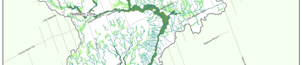
24 A boundary was created between the Lower and Middle-to-Upper Watersheds using major watershed roads, to guide the criteria for the NHS and to provide for clear identification of zones at the site level (Figure 2). The two zones created by this boundary were termed the Northern zone (consisting of the Middle and Upper Watersheds) and the Southern zone (consisting of the Lower Watershed and a small portion of the Middle Watershed). The roads dividing the Northern zone from the Southern zone are as follows: Credit River watershed eastern boundary south along Heritage Road to Mayfield Road, west along Mayfield Road to Winston Churchill Boulevard, south along Winston Churchill Boulevard to 10 th Sideroad, west along 10 th Sideroad to the Credit River watershed western boundary. The Northern and Southern zone boundary matches the Greenbelt Plan boundary fairly closely and more loosely matches the Ecodistrict (ecological) boundary. The Northern and Southern zones also differentiate between high natural cover, rural areas of the watershed and lower natural cover, urban or urbanizing areas of the watershed. Credit Valley Conservation 13


25 Figure 2. Physiographic regions, physiographic zones, and Northern and Southern zones of the Credit River watershed in relation to the Ecodistrict boundaries and the Greenbelt boundary. Credit Valley Conservation 14
26 7. Development of the NHS Credit Valley Conservation s most recent and detailed mapping data for ecological and land use classifications were used in developing the NHS. These layers included the Ecological Land Classification (ELC) community series layer (updated 2012), which represents a standardized hierarchical classification system used for the description, inventory, and interpretation of ecological units at a local scale in southern Ontario (Lee et al. 1998, Crins et al. 2009), and the land use/land cover layer also last updated in Data preparation included an extensive GIS quality assurance and quality control process in preparation for mapping the NHS. Data preparation also included development of a valleylands mapping methodology and mapping of valleylands for the entire CVC jurisdiction; development of an aquatic habitat methodology and mapping of aquatic habitat for the NHS; preparation and review of a woodlands layer prior to mapping NHS woodlands; preparation, review and field checks for the Centres for Biodiversity layer; and a review and update of the watercourse layer, all in consultation with CVC technical staff across departments. The NHS is composed of a system of natural heritage features and areas connected by multifunctional linkages (valleylands and watercourses). The Credit River and its main tributaries form the backbone and main linkages of the NHS. The NHS was developed using a vector based approach that utilizes landscape ecology and conservation biology criteria to identify features and areas for inclusion within the system. The NHS was developed through multiple steps as follows: 1. Identify targets for overall natural cover, function, and quality in the Credit River watershed to guide system development; 2. Develop criteria for components of the NHS through review of scientific literature, existing provincial guidance documents, and use of best available science within a watershed context. Develop thresholds for criteria based on provincial guidance, scientific literature, existing best practice and professional judgement of technical committees and external peer reviewers; 3. Map the components of the NHS following standardized methodology using geographical information systems (GIS). Combine components into a single GIS layer that represents the mapped NHS and review system mapping; and 4. Compare resulting NHS to recommended natural cover targets. Additionally, compare system to the Credit River Watershed Landscape Credit Valley Conservation 15
27 Scale Analysis which scored and ranked existing habitat patches in the watershed to ascertain inclusion of high quality habitat patches from a landscape perspective, and adjust criteria if necessary. The NHS consists of natural heritage features and their buffers, and natural heritage areas (Table 2). These system components include natural land cover as well as agriculture or open space land cover and land use that would be most effective and efficient in maintaining and enhancing the functionality and connectedness of the NHS. The system also includes urban land uses that currently provide some limited ecological function due to their placement in the system (e.g. infiltration, habitat, linkage functions on the Lake Ontario shoreline or in valleylands). Appropriate management, stewardship, restoration or redevelopment of these enhancement areas (i.e. agriculture, open space or urban areas) as desired and appropriate would help mitigate negative impacts and improve ecological or hydrological function of the system. The identification of these enhancement areas is consistent with the natural heritage systems planning direction provided by the province of Ontario in the Provincial Policy Statement (OMMAH 2014) in which lands that have been restored or have the potential to be restored to a natural state, areas that support hydrologic functions, and working landscapes that enable ecological functions to continue can be included in a natural heritage system. Table 2. Components of the NHS. Natural heritage features Valleylands High Functioning and Supporting Wetlands - High Functioning and Supporting Woodlands High Functioning and Supporting Aquatic habitat High Functioning and Supporting Lake Ontario shoreline High Functioning Significant wildlife habitat High Functioning Habitat of endangered species and threatened species High Functioning Buffers Buffers on specific natural heritage features to protect the features and their functions from adjoining land uses Natural heritage areas Centres for Biodiversity It is the combination of the natural heritage features, enhancement areas and their buffers, in their entirety, that come together to form the system (Figure 3). When implementing the NHS it is essential that the structural and functional characteristics of the system (e.g. amount and distribution of natural cover, Credit Valley Conservation 16
28 connectivity, and hydrology) be maintained and enhanced in order to sustain or improve the function of the Credit River watershed. Figure 3. Schematic showing the Credit River Watershed Natural Heritage System and its components. Credit Valley Conservation 17
29 7.1 Natural heritage features The natural heritage features component includes ecological features in the Credit River watershed that collectively are important for maintenance of biodiversity and ecological function in the watershed. It includes features that collectively provide life-sustaining ecological functions to humans and the watershed s flora and fauna such as flow moderation, stream or air temperature moderation, water quality and nutrient regulation, soil formation, or pollination. It includes but is not limited to ecological features identified for protection in provincial policy and guidelines (Provincial Policy Statement and the Natural Heritage Reference Manual, respectively) for protection of natural heritage: valleylands, wetlands, woodlands, aquatic habitat, the Lake Ontario shoreline, significant wildlife habitat, and habitat for endangered species and threatened species. Each of these sub-components are defined and described in detail in the following chapters Categorization of natural heritage features The natural heritage features that comprise the major building blocks of the NHS have been classified into three major categories (below) to reflect relative differences in function at the watershed scale and to provide guidance for future implementation: High Functioning, Supporting and Contributing. Specific criteria and thresholds for determining inclusion of these natural features in the natural heritage system are discussed in subsequent chapters. Many natural heritage features have multiple roles and functions. For example, treed wetlands or swamps meet the definition of both woodlands and wetlands; and wetlands may also function as aquatic habitat. A natural heritage feature may also fall under two different relative importance categories (for example, a treed swamp may classify as a Supporting woodland but also as a High Functioning wetland, based on ecological criteria for inclusion in the NHS). In such cases, it is recognized that the feature provides multiple functions and management or protection of the feature should consider all the functions provided by the feature High Functioning features High Functioning natural heritage features represent key features from a watershed and/or provincial perspective that are essential for maintaining biodiversity and ecological function within the watershed over the long term. Collectively these features are essential for ensuring the integrity and resilience of the NHS. Some of these features are of provincial significance (e.g. are Provincially Significant Wetlands or Areas of Natural and Scientific Interest). Others may be deemed significant by planning authorities according to the PPS (e.g. valleylands, woodlands, or significant wildlife habitat). Cumulative impacts to these features are likely to have a significant impact on the resilience and selfsustainability of the NHS. Credit Valley Conservation 18
30 High Functioning features in the NHS are comprised of High Functioning valleylands, High Functioning wetlands, High Functioning woodlands, High Functioning aquatic habitat, High Functioning Lake Ontario shoreline, High Functioning significant wildlife habitat, and High Functioning habitat of endangered species and threatened species Supporting features Supporting features represent features that play a supporting role within the watershed. These features enhance the quality and function of High Functioning features and collectively are highly likely to improve the resilience of the NHS. These features contribute to meeting science-based and federal guidelines for overall natural cover within the watershed, help maintain the abundance of common species in the landscape, and improve connectivity as stepping stone habitat or tableland linkages. The cumulative loss of these features will have some impact on overall levels of natural cover in the watershed and may locally impact High Functioning features. Supporting features in the NHS are comprised of Supporting valleylands, Supporting wetlands, Supporting woodlands, and Supporting aquatic habitat Contributing features Contributing features are features that play a contributing role within the watershed. These features may contribute to connectivity across the landscape. They are typically very small and may also be relatively isolated from other natural heritage features. In urban areas they may be especially valued for their social function. Contributing features are comprised of Contributing wetlands, Contributing woodlands, Contributing aquatic habitat, and headwater drainage features contributing to valleylands. Contributing features are not generally included in the NHS, unless they are part of a more important feature or area (for example, a small woodland located in the floodplain of the Credit River would be included, but is primarily classified as a valleyland natural heritage feature; or a small wetland located in a natural heritage area would be included in the NHS due to its classification as a Centre for Biodiversity). 7.2 Buffers Buffers represent minimum areas around natural heritage features that protect or mitigate impacts on their functions from existing or future adjacent land uses. The ecological protection that buffers provide can include protection of water quality, area for infiltration, mitigation of edge effects, and protection of rooting Credit Valley Conservation 19
31 zone of trees within the feature. In some cases vegetated buffers may provide supplementary habitat for species although that is not their primary function. Minimum buffer widths have been mapped in the NHS around specific features, including valleylands, wetlands, woodlands and aquatic habitat. The widths specified represent minimums, and all natural heritage features need to be further evaluated through the planning process on site. An evaluation should consider the function and sensitivity of the feature in order to evaluate appropriate buffer width and composition. 7.3 Natural heritage areas This component includes natural heritage areas that collectively improve the likelihood of retaining biodiversity and ecological function in the NHS. The criterion for natural heritage areas (namely Centres for Biodiversity), is supported by landscape ecology and conservation biology science and emerging practice (e.g. Centres for Biodiversity in the Region of Halton s Regional Natural Heritage System, and the Big Woods concept in the Natural Heritage System for the Lake Simcoe watershed) Centres for Biodiversity Centres for Biodiversity are landscapes with a concentration of natural heritage features representative of physiographic regions in the watershed, which collectively represent important ecological features and functions capable of supporting native biodiversity over the long term. Centres for Biodiversity contain the best representative aggregations of natural features such as woodlands, wetlands, and aquatic habitat. They may also contain other habitat that contributes to diversity or connectivity of ecosystems on the landscape, such as tableland successional areas, agriculture, open space, or urban land use. All components of the NHS cannot be mapped. While every effort has been made to ensure data quality and currency, some minor mapping errors may exist and will be corrected as appropriate. In addition, features may change over time or field verification may alter mapping. Therefore the intent of this report is that the text of the criteria for identifying the NHS supersedes the mapping. In some cases, natural heritage features or areas may meet the criteria for inclusion in the NHS based on the systems approach taken that is, they are important based on their landscape functional role - but may possess attributes at the site level that impede their optimal functioning (e.g. contain large numbers of invasive species). The intent of the natural heritage system is to identify features that are important for the long term functioning of the watershed from a systems perspective. Developing stewardship or management plans for these Credit Valley Conservation 20
32 features or areas can help improve their ecological health at the site scale while retaining their importance at landscape scale. It is intended that the NHS be viewed as a single system and implemented using a systems approach. The inclusion of non-natural land uses in the NHS (such as agriculture, open space or urban) to create a more resilient, self-sustaining system is consistent with the natural heritage systems planning direction provided by the province of Ontario in the Provincial Policy Statement (OMMAH 2014) in which lands that have been restored or have the potential to be restored to a natural state, areas that support hydrologic functions, and working landscapes that enable ecological functions to continue can be included in a natural heritage system. Lands outside the mapped system that are associated with the protection of the ecological function of important natural heritage features or the NHS may also be included as part of the system to prevent the loss or degradation of ecological function (e.g. adjacent lands), following further study. These lands are not currently mapped as part of the NHS because they require detailed site level investigations to determine their relationship to a natural heritage feature, extent of the relationship and potential mitigation options (if protection of function is ensured). Once identified, these lands would be considered part of the NHS. Table 3 lists the components of the NHS, along with criteria and thresholds for mapping the system. Specific components are described briefly in the following chapters. Credit Valley Conservation 21
33 Table 3. Components of the NHS with criteria, thresholds and categories. Natural Heritage System criteria and thresholds Natural heritage features 1. Valleylands 1. Valleylands 1a) Credit River and its major tributaries, and major watercourses draining to Lake Ontario Northern and Southern zone: i) Valleylands of the Credit River and major tributaries, namely those having direct confluence with the Credit River; and Category High Functioning ii) Valleylands of major watercourses (Sheridan Creek and Cooksville Creek) having direct drainage to Lake Ontario, from their outlet to the farthest upstream extent of their defined valley landform 1b) Valleylands supporting surface water functions (conveyance, attenuation, storage and release), productivity, and linkage functions Northern zone and Southern zone: All other valleylands associated with watercourses 2. Wetlands 2. Wetlands 2a) Size Northern and Southern zone: i) All wetlands >2 ha ii) All wetlands >0.5 ha and <2 ha 2b) Proximity Northern and Southern zone: All wetlands >0.5 ha and <2 ha within 30 m of a High Functioning woodland, High Functioning wetland, or High Functioning valleyland 2c) Surface water quality and quantity, multifunctional linkage Northern and Southern zone: All wetlands >0.1 ha and <2 ha located within or adjoining a valleyland 3. Woodlands 3. Woodlands 3a) Size i) Northern zone: All woodlands >16 ha ii) Southern zone: All woodlands >4 ha iii) Northern zone: All woodlands >4 ha and <16 ha iv) Southern zone: All woodlands >2 ha and <4 ha 3b) Interior i) Northern zone: All woodlands <16 ha containing >0.5 ha interior habitat (100 m from woodland edge) ii) Southern zone: n/a (no woodlands <4 ha have interior) 3c) Proximity i) Northern zone: All woodlands >2 ha and <16 ha within 30 m of a High Functioning woodland, High Functioning wetland, or High Functioning valleyland ii) Southern zone: All woodlands >0.5 ha and <4 ha within 30 m of a High Functioning woodland, High Functioning wetland, or High Functioning valleyland High Functioning Supporting High Functioning Supporting Supporting Supporting High Functioning Supporting Supporting Supporting Supporting Credit Valley Conservation 22
34 Natural Heritage System criteria and thresholds Category 3d) Surface water quality and quantity, multifunctional linkage i) Northern zone: All woodlands >0.5 ha and <16 ha Supporting within or adjoining a valleyland 4. Aquatic habitat and 5. Lake Ontario shoreline 6. Significant wildlife habitat 7. Habitat of endangered species and threatened species ii) Southern zone: All woodlands >0.5 ha and <4 ha within or adjoining a valleyland 4. Aquatic habitat 4a) Watercourses Northern and Southern zone: i) All watercourses containing or linking habitat for top predators associated with the following aquatic communities: a) Coldwater Brook Trout Fish Community; b) Coldwater Brown Trout/Rainbow Trout/Atlantic Salmon Fish Community; c) Large Warmwater and Migratory Coolwater Fish Community; and d) Estuarine Fish Community ii) All other watercourses 4b) Water bodies Northern and Southern zone: i) Lake Ontario within CVC jurisdiction ii) All lakes that a) are not created and maintained by human infrastructure such as a dam; and b) are of aggregate origin whose aggregate license has been surrendered and show evidence of naturalization iii) All lakes that are created and maintained by human infrastructure such as a dam; iv) All water bodies >2 ha of aggregate origin whose aggregate license has recently been surrendered v) All water bodies >0.5 ha and <2 ha within 30 m of a High Functioning valleyland, High Functioning wetland, or High Functioning woodland 5. Lake Ontario shoreline All areas within Lake Ontario shoreline defined by Lake Ontario Flood Hazard, Lake Ontario Erosion Hazard, and Lake Ontario Dynamic Beach Hazard 6. Significant wildlife habitat Northern and Southern zone: All habitat identified as significant wildlife habitat 7. Habitat of endangered species and threatened species Northern and Southern zone: All habitat identified for protection as habitat of endangered species and threatened species Supporting High Functioning Supporting High Functioning A High Functioning A High Functioning B Supporting Supporting High Functioning High Functioning High Functioning Credit Valley Conservation 23
35 Buffers 8. Buffers on natural heritage features Credit River Watershed Natural Heritage System Natural Heritage System criteria and thresholds Category 8. Buffers High Functioning valleylands: Crest of slope or meander belt - minimum 30 m plus evaluation n/a High Functioning wetlands: Minimum 30 m plus evaluation High Functioning woodlands: Minimum 30 m plus evaluation High Functioning aquatic habitat (water bodies): Minimum 30 m plus evaluation Supporting aquatic habitat (water bodies): minimum 30 m if it adjoins a High Functioning wetland plus evaluation Supporting wetlands: Minimum 10 m plus evaluation Supporting woodlands: Minimum 10 m plus evaluation Supporting aquatic habitat (water bodies): Minimum 10 m unless it adjoins a High Functioning wetland plus evaluation All other natural heritage features: To be evaluated Natural heritage areas 9. Centres for 9. Centres for Biodiversity Biodiversity Landscapes with a concentration of natural heritage features, encompassing the top 5% of habitat patches by area within Northern and Southern zones, representative of the eight major watershed physiographic regions, an inland lake and an estuarine area, that collectively represent important ecological features and functions capable of supporting native biodiversity in the long term n/a The following chapters in this report describe the components, sub-components, and associated criteria and thresholds for the NHS. Credit Valley Conservation 24
36 8. Natural heritage features 8.1 Valleylands Valleys are linear systems that stretch across the landscape from their origins in headwater areas to their outlets into other aquatic systems such as wetlands and lakes (OMNR 2010). These areas are generally though not always associated with a watercourse and may be shaped and re-shaped by natural processes such as flooding and erosion. A review of the science shows that valleylands support a number of ecological functions including providing habitat for species and communities, (Naiman et al. 1993, Naiman and Decamps 1997), connecting natural heritage features (e.g. Opperman et al. 2010, Tremblay and St. Clair 2011), containing natural heritage features such as watercourses and wetlands, transporting sediment, nutrients, and organic matter (Vannote et al. 1980, Wipfli et al. 2007), maintaining water quantity and quantity (Naiman and Decamps 1997), and moderating stream temperature (e.g. Wenger 1999). Valleylands that link natural heritage features serve an important multifunctional linkage function for plants and wildlife and improve the functionality of these features. Maintaining linkages for plant and animal movement is also suggested as a climate change adaptation strategy. The province of Ontario has identified valleylands as important features in natural heritage systems planning and provided criteria for identification of significant valleylands (OMNR 2010). In a rural landscape, upland or tableland areas also provide linkages across the landscape for a number of species. The role of valleylands or other tableland corridors gains in importance when the surrounding matrix becomes less permeable to plant or wildlife movement, e.g. as urbanization occurs. A valleyland is defined as land that has depressional features associated with a river or stream, whether or not it contains a watercourse. (CAA 1990). The guidance provided by the Natural Heritage Reference Manual (2010) and the consideration of methodologies for defining valleylands already in existence within the watershed (Region of Peel, Town of Caledon) led Credit Valley Conservation to identify and map valleylands by the following method: 1) Defined valleylands: The crest of slope determined the physical boundary of the feature. 2) Ill-defined valleylands: The greater of the following determined the physical boundary of an ill-defined valleyland: i) regulatory floodplain; ii) meander belt; iii) boundary of online wetland or online pond; or iv) 30 m on each side of a watercourse. Valleylands mapping methodology is covered in greater detail in a separate technical appendix (CVC 2014 in preparation). Credit Valley Conservation 25
37 Floodplains and valley slopes to the stable top of bank are part of valleylands (OMNR 2010). Floodplains and valley slopes have traditionally been viewed as hazard lands rather than valleylands but that is primarily because humans occupied these areas of active hydrological or ecological activity. Even urban, agriculture or open space in valleylands contribute to maintaining natural hydrologic processes such as infiltration of water, moderation of flow velocity and some sediment and nutrient removal, although these areas can also have negative impacts or their function may be impaired relative to valleylands with natural cover. These areas also facilitate connectivity within the NHS for some species. Finally, the inclusion of hazard lands within the NHS supports an important system objective to protect human life and property. The boundary of valleylands is subject to refinement, review and approval by Credit Valley Conservation. In the Credit River watershed, valleylands reflect past patterns of human land use and contain large amounts of remnant natural cover. Valleylands are made up of natural cover as well as non-natural land uses namely agriculture, open space, or urban. Localized urbanization exists in certain valleylands (e.g. Cooksville Creek in the Southern zone and the village of Glen Williams in the Northern zone). Non-natural areas provide some limited ecological or hydrological function in valleylands, such as storage of flood water, infiltration, or nutrient modification, although sometimes these functions can be impaired. Nonnatural areas provide opportunities to enhance natural cover and linkages across the watershed through best management practices or stewardship. These areas are included in the NHS because it is important to maintain valleyland functions to the extent possible, and to prevent further deterioration of these functions. All areas classified as agriculture, open space, or urban within valleylands are also identified as enhancement areas (i.e. as areas where stewardship efforts could be focused). Policies relating to these non-natural areas in valleylands can be developed by planning authorities to improve ecological or hydrological functions to the extent possible, while acknowledging existing legal uses within these natural heritage features. High Functioning and Supporting valleylands have been identified as part of the NHS (Table 3). High Functioning valleylands include the Credit River and its major tributaries, as well as valleylands of major watercourses (Sheridan Creek and Cooksville Creek) having direct drainage to Lake Ontario, from their outlet up to the farthest upstream extent of their defined valley landform. These valleylands form the backbone of the NHS. The main Credit River valley links major provincial corridors, namely the Lake Ontario shoreline and the Niagara Escarpment and Oak Ridges Moraine. In addition, major watercourses draining directly to Lake Ontario fulfill an important flow moderation and linkage function in the Lower Watershed. The remainder of the valleylands in the watershed are considered Supporting valleylands, and are important for the conveyance, Credit Valley Conservation 26
38 attenuation, storage and release of water, the provision and conveyance of organic and inorganic nutrients, and as productive aquatic habitat. High Functioning valleylands cover 7% of the total watershed area and Supporting valleylands cover an additional 16%, for a total valleyland coverage of 23% of watershed area; these valleylands are mapped in Figure 4. Criteria for identifying valleylands in the NHS are detailed in Table 3. Criteria used to identify High Functioning valleylands and Supporting valleylands in the NHS are appropriate for and provide scientific support to identifying significant valleylands from a regional or area municipal perspective. Additionally, conservation authorities are mandated to regulate valleylands under the Conservation Authorities Act. Credit Valley Conservation 27

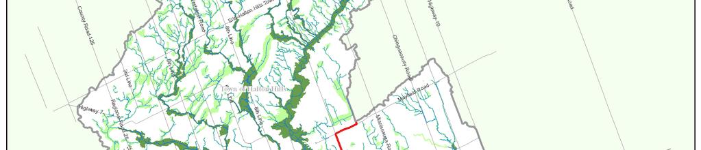
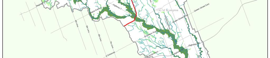
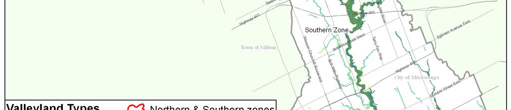
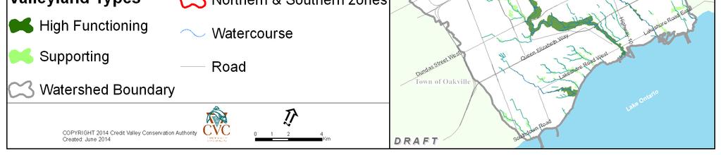
39 Figure 4. High Functioning and Supporting valleylands of the NHS, mapped with associated watercourses. Credit Valley Conservation 28
40 8.2 Wetlands Wetlands are some of the most ecologically diverse, productive, and socioeconomically useful habitats in the world (Mitsch and Gosselink 2000). Ecological and hydrological functions of a wetland include storing and releasing surface water, recharging and discharging groundwater, maintaining and improving water quality, creating and decomposing organic matter, creating soil, storing and processing nutrients, sediments or compounds, releasing nutrients to adjoining upland areas, wetlands, and aquatic habitat, climate regulation, and providing habitat for species and communities (Daily 1997, Mitsch and Gosselink 2000). There are four major wetland types in the Credit River watershed: marshes, swamps, bogs and fens. Treed wetlands or swamps are ecosystems that by their nature provide a variety of woodland functions as well as wetland functions. They are therefore considered to be both woodlands and wetlands. As such, statistics provided for woodland and wetland cover in this report are not additive. Wetland means land that: a) is seasonally or permanently covered by shallow water, or has a water table close to or at its surface, b) directly contributes to the hydrologic function of a watershed through connection with a surface watercourse, c) has hydric soils, the formation of which has been caused by the presence of abundant water, and d) has vegetation dominated by hydrophytic plants or water tolerant plants, the dominance of which has been favoured by the presence of abundant water, but does not include periodically soaked or wet land that is used for agricultural purposes and no longer exhibits a wetland characteristic referred to in clause (c) or (d). (CAA 1990). Wetlands are estimated to have covered about 10.4% of watershed area at the time of European settlement (Dougan and Associates et al. 2009). Currently wetlands occupy about 6.8% of the Credit River watershed s area and are unevenly distributed across subwatersheds. Nearly 70% of all wetlands in the Credit River watershed are smaller than 2 ha in area. Swamps are the dominant wetland type in the watershed, accounting for 84% of wetland types, followed by marshes at 16%; bogs and fens account for a very small number of wetlands. Criteria that have been used to define High Functioning and Supporting wetlands include size, proximity, and surface water quality and quantity (Table 3) and are supported by the scientific literature as well as the CVC Wetland Restoration Strategy (Dougan and Associates et al. 2009). The wetlands size criterion recognizes that wetlands of a variety of sizes and hydroperiods are important for maintaining the diversity of wetland species and communities within a watershed, with larger wetlands collectively providing relatively greater function as a consequence of their greater area and interspersion of habitat (Golet et al. 2001, Webb et al. 2010, OMNR 2013). In addition, wetlands in proximity to other natural heritage features support local populations of species, may be functionally connected to these features, or provide Credit Valley Conservation 29
41 supportive functions relating to water quantity and quality (e.g. Semlitsch and Bodie 2003). Finally, wetlands within or adjoining valleylands are important from a systems perspective in supporting water quality and aquatic habitat, flow moderation, and habitat or movement function for species (Mitsch and Gosselink 2007, OMNR 2010). In total, High Functioning and Supporting wetlands cover 6.8% of watershed area (Figure 5). All criteria for identifying wetlands in the NHS are detailed in Table 3. High Functioning wetlands and Supporting wetlands are features that are considered important wetlands in a watershed context. Many of these wetlands are Provincially Significant Wetlands and identified for policy protection under the PPS. In addition, some wetlands may be identified in future as Provincially Significant Wetlands following OMNR evaluation. Others represent wetlands collectively important for healthy watershed function, and may be considered locally significant wetlands that are important from a municipal perspective. Additionally, conservation authorities are mandated to regulate wetlands under the Conservation Authorities Act. Credit Valley Conservation 30

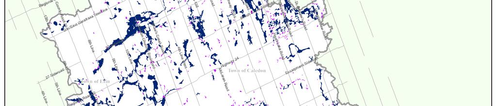
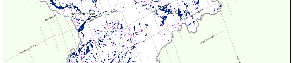
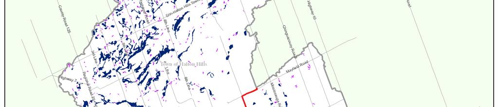
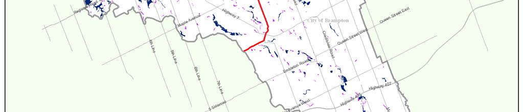
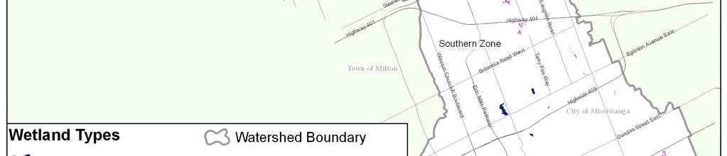
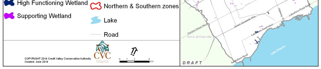
42 Figure 5. High Functioning and Supporting wetlands of the NHS. Credit Valley Conservation 31
43 8.3 Woodlands Woodlands include upland forest and may include other types of treed habitats such as plantations, swamps, or cultural savannahs. Woodlands are the dominant historic ecosystem of southern Ontario and hold much of the region s biodiversity. As such, they are extremely important for the ecological functions that they provide and for maintenance of watershed biodiversity. Woodlands provide a variety of functions including gases regulation, climate regulation, water regulation, soil formation, nutrient cycling, and habitat for species and communities (Costanza et al. 1997, de Groot et al. 2002). In addition, woodlands provide a variety of ecological goods and services, including provision of food, fibre or genetic materials, reduction of air pollution, mitigation of the urban heat island effect, and provision of opportunities for recreation, aesthetic, educational and scientific services. Woodland, for the purposes of identifying the Credit River Watershed Natural Heritage System, is defined as: a) a tree crown cover of over 35% of the ground, determinable from aerial photography; or b) a tree crown cover of over 25% of the ground, determinable from aerial photography, together with on-ground stem estimates of: 1,000 trees of any size per hectare, or 750 trees measuring over five centimetres in diameter, per hectare, or 500 trees measuring over 12 centimetres in diameter, per hectare, or 250 trees measuring over 20 centimetres in diameter, per hectare but does not include a cultivated fruit or nut orchard or a plantation established for the purpose of producing Christmas trees (stem estimates based on the Forestry Act of Ontario, R.S.O For the purposes of a) and b), the tree amount is based on the average per hectare across the entire treed area. Woodlands exclude nurseries, plantations that are managed for tree products with an average rotation of less than 20 years (e.g. hybrid willow or poplar) and plantations that are continuously managed for the sole purpose of complete removal at rotation without a reforestation objective, as demonstrated with appropriate documentation. Woodlands that meet the above definition of woodlands but are altered by disturbance, pests, or disease (e.g. blowdown, fire, or invasive pest infestation) would still be considered as woodlands. The changes are considered temporary whereby the woodlands still retain their long-term ecological value, and still have the capacity to be restored to natural cover and eventually to woodland over time. Woodlands currently cover 23% of watershed area, and woodland cover is unevenly distributed across physiographic regions and zones. As such, different thresholds have been used in the Northern and Southern zones to identify woodlands for inclusion in the NHS (Table 3). Criteria that were used to define High Functioning and Supporting woodlands included size, interior, proximity, and surface water quantity and quality, multi-functional linkage (Table 3). Credit Valley Conservation 32
44 Prior to identifying woodlands for the NHS, a woodland shapefile was created for NHS woodlands mapping based on CVC s Ecological Land Classification mapping. Woodlands separated by less than 20 m were treated as a single woodland patch as they function in many ways as a single woodland patch. Woodlands separated by standard roads (e.g. regional roads, city streets) continued to be identified as separate woodlands. Long, narrow woodland extensions or hedgerows (e.g. greater than 30 metres long and less than 20 metres wide) were identified as hedgerows and a break was inserted to separate them from the main portions of the woodlands to which they were attached. In general, small natural openings in a woodland (smaller than 0.5 ha) were left in, but similarly small openings that were urban or manicured open space were not considered part of a woodland. Guidelines for identifying woodlands in the Greenbelt Plan take a similar approach by eliminating long narrow treed areas between woodlands and generally including small openings in woodlands as long as they collectively occupy less then 25% of woodland area (OMNR 2012). The woodland size criterion was based on the principle that larger woodlands within a zone tend to contain (or have the potential to contain) higher species and community biodiversity than smaller woodlands (Freemark and Merriam 1986, Villard et al. 1999, Lee et al. 2002). A woodland interior criterion was also included to identify additional woodlands that have less edge relative to their total area, as landscapes should have a mix of both edge and interior area, to mitigate for some of the negative impacts associated with edges (see Austen et al. 2001, Chalfoun et al. 2002). A proximity criterion identified woodlands that are close to woodlands or other natural features; these are collectively of greater benefit to wildlife and may be functionally connected to neighbouring features (e.g. Hewitt and Kelman 2002, Semlitsch and Bodie 2003). Finally, woodlands that were associated with valleylands or surface water features were identified, as these areas are known to perform an important role in enhancing the quality of surface water and aquatic habitat and the quality or quantity of groundwater; these woodlands may also function as conduits for material flows between aquatic and terrestrial environments (Gartner Lee Limited 2002, Sweeney et al. 2004, Rios and Bailey 2006) or as linkages for certain species that may use valleylands for habitat or movement. In total, High Functioning woodlands cover 18% of watershed area and Supporting woodlands in the Natural Heritage System cover 4% of watershed area (Figure 6). Criteria for identifying woodlands in the NHS are detailed in Table 3. In keeping with NHS system design objectives relating to quantity and distribution of natural cover for coverage of ecosystem benefits across the watershed, different thresholds were set for woodlands criteria in the Southern zone compared to the Northern zone. The different thresholds for the two zones follows provincial guidance (OMNR 2010) and reflect the fact that woodlands in the Southern zone provide a variety of ecosystem and social benefits to urban and urbanizing areas. Credit Valley Conservation 33
45 Cultural savannahs represent features that may or may not be woodland according to the definition of woodlands used for the NHS, and typically would need site evaluation (on-ground stem density estimates) to determine whether they are woodlands. Therefore, cultural savannahs were not mapped in the NHS but would be included in the system upon site evaluation. Some cultural savannahs may be included in the NHS as portions of other features (e.g. in valleylands, Centres for Biodiversity, or buffers).and are important in contributing to natural heritage system targets relating to the diversity of habitat types in the watershed. Criteria used to identify High Functioning woodlands and Supporting woodlands are appropriate for and provide scientific support to identifying significant woodlands from a regional or area municipal perspective. In addition, there may be other woodlands not included in this version of the mapping that meet the criteria for significant wildlife habitat (e.g. woodlands with uncommon characteristics, older woodlands) and should be further evaluated for their inclusion in the NHS. Finally, there may be other science-based woodland criteria that could be considered compatible with provincial direction for the identification of significant woodlands by planning authorities (e.g. science-based criteria selected by municipalities). Credit Valley Conservation 34

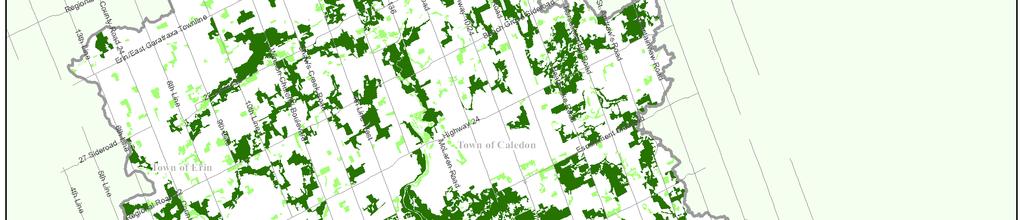
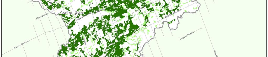
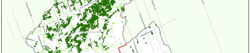
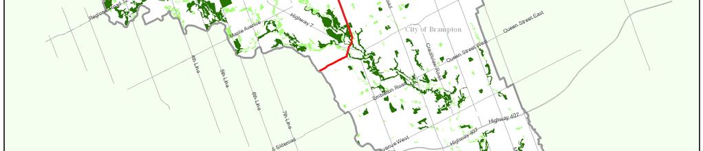
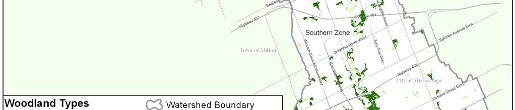
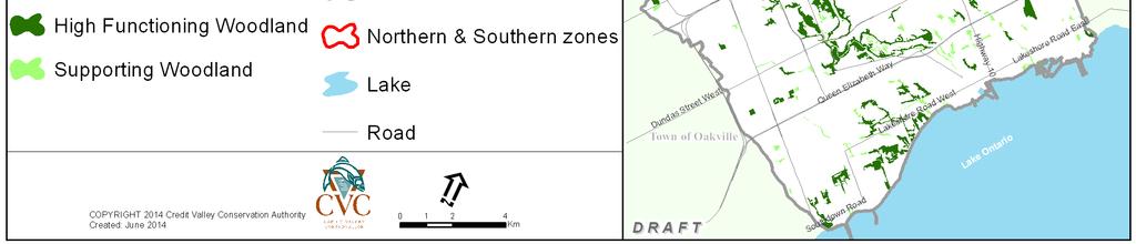
46 Figure 6. High Functioning and Supporting woodlands of the NHS. Credit Valley Conservation 35
47 8.4 Aquatic habitat and Lake Ontario shoreline Aquatic habitat, along with associated valleylands and riparian zones, is associated with many important watershed functions (Wetzel 2001). Aquatic habitat contributes directly or indirectly to the life-cycle of all species. In addition, aquatic habitat provides multiple ecological functions, including storage, release and conveyance of water, water purification and supply, ground water recharge and discharge, nutrient and materials cycling, sediment transport and deposition, and microclimate regulation. Aquatic habitat is critical for aquatic species in the watershed, including fish (CVC 2002a). A large number of terrestrial species depend on water for part of their life-cycles aside from water consumption (CVC 2002b, 2002c, 2002d), and some such as beaver, mink, herons, frogs and turtles are also considered aquatic species. In addition, virtually all aquatic habitat as defined here is also fish habitat as defined under the PPS. Aquatic habitat and the Lake Ontario shoreline are included in the NHS because terrestrial and hydrologic ecosystems are functionally linked. For the purposes of the NHS, aquatic habitat is defined as the following: - All watercourses - Lake Ontario (within CVC jurisdiction) - All water bodies that form part of the aquatic system of the watershed. These include areas classified through air photo interpretation using Ecological Land Classification as Open Aquatic (OAO) or Shallow Water (SA, all types). Some areas (namely Open Aquatic or Shallow Water) classified as aquatic habitat through air photo interpretation in CVC s ELC mapping may also be defined as wetland under the Ontario Wetland Evaluation System (OWES; OMNR 2013). Specific watercourses and water bodies, and the Lake Ontario shoreline, have been identified as components of the NHS. Watercourses and water bodies provide habitat for aquatic life in the watershed. Watercourses and their associated valleylands provide a major linkage function among natural heritage features, aquatic species and communities, and among terrestrial and hydrologic components (Wetzel 2001). Credit Valley Conservation s existing fish community classifications for the watershed based on current fish collection and spawning data (CVC in preparation) were used to identify High Functioning and Supporting aquatic habitat for the NHS. These classifications also reflect thermal regime, flow regime and stream morphology. The presence of self-sustaining fish communities are a surrogate for assessing relative aquatic habitat site quality for all aquatic dependent species at the landscape scale. Water bodies represent distinct watershed hydrological and ecological features that provide functions such as water storage and infiltration, nutrient cycling, and habitat for aquatic and terrestrial species. Water bodies were classified into High Functioning and Supporting based on their form and function (Table 3). Several water bodies are also wetlands. The shoreline of Lake Ontario provides a zone of interaction between land and water, supports natural lake processes, provides important habitat for migratory Credit Valley Conservation 36
48 species and supports the movement of species along the shoreline. The Lake Ontario shoreline was identified as a High Functioning natural heritage feature and mapped utilizing the Lake Ontario hazards mapping. All criteria for identifying aquatic habitat and the Lake Ontario shoreline in the NHS are detailed in Table 3 and mapped in Figure 7. Credit Valley Conservation 37


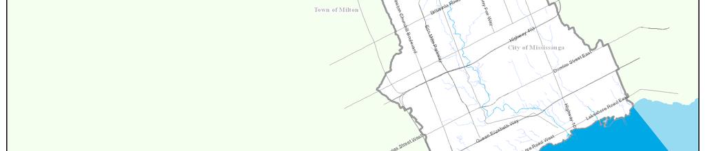
49 Figure 7. Aquatic habitat and the Lake Ontario shoreline in the NHS. Credit Valley Conservation 38
50 8.5 Significant wildlife habitat Significant wildlife habitat represents important areas where species find resources and space to sustain their life cycles. They may be particular locations terrestrial or aquatic - that represent seasonal concentration areas for species, specialized habitats of plants or animals, habitats of species of conservation concern, or movement corridors for wildlife. Examples include (but are not limited to) the following: Habitat for species of conservation concern Migratory landbird stopover areas Waterfowl nesting habitat Forests providing a high diversity of habitats Rare vegetation communities Old-growth or mature forest stands Cliffs and caves Wildlife habitat is defined under the Provincial Policy Statement (OMMAH 2014) as areas where plants, animals and other organisms live, and find adequate amounts of food, water, shelter and space needed to sustain their populations. Specific wildlife habitats of concern may include areas where species concentrate at a vulnerable point in their annual or life cycle; and areas which are important to migratory or non-migratory species. Significant in terms of the PPS means ecologically important in terms of features, functions, representation or amount, and contributing to the quality and diversity of an identifiable geographic area or natural heritage system. All significant wildlife habitat is included in the NHS (Table 3). Significant wildlife habitat is compatible with a fine filter approach recognized in natural heritage systems planning (e.g. Henson et al. 2005), where landscape based criteria alone capture most but not all of the important areas required for maintenance of species diversity in a landscape, and a criterion is required that captures important wildlife habitat identified through data collection and analysis that is not within the mapped system. Technical guidance for identifying significant wildlife habitat is available from the Province (OMNR 2000), and has been refined for Peel Region (North-South Environmental Inc. et al. 2009) as well as for Ecodistricts (OMNR 2012a, OMNR 2012b). Planning authorities are required to protect significant wildlife habitat in their jurisdictions under the current PPS. Most planning authorities in the Credit River watershed have not identified or mapped significant wildlife habitat in their Official Plans; however, each Official Plan will contain policies that are consistent with the PPS that protects significant wildlife habitat. The fact that significant wildlife habitat may not have been identified in an area does not mean that it does not exist. Detailed inventories are required to verify to presence or absence of significant wildlife habitat. Credit Valley Conservation 39
51 Significant wildlife habitat is frequently associated with the natural heritage features (e.g. valleylands, woodlands, wetlands, aquatic habitat) already contained within the mapped boundary of the NHS. However, there may be instances where small natural heritage features outside the mapped system are found to contain significant wildlife habitat. It is these features that would then be included within the NHS under the significant wildlife habitat criterion. Significant wildlife habitat is not currently shown in system mapping because all locations of this habitat are not known for the watershed, and the location of some significant wildlife habitat may be sensitive information. 8.6 Habitat of endangered species and threatened species A species is considered to be at risk when numbers, sizes, or locations of populations fall below nationally or provincially determined thresholds. The protection of habitat of endangered and threatened species, especially habitat essential for reproduction or survival at critical points in the life cycle, is essential for the recovery of these species at risk (OMNR 2010). Protection of the habitat of these species is necessary to slow or prevent the extinction of these species provincially, nationally or globally, and to meet objectives of maintaining or enhancing biodiversity at these scales. Species at risk contribute to the watershed s biodiversity and ecological function. Consequently it is beneficial to maintain these species, their habitat and their overall functions on the landscape to fulfill natural heritage system objectives of maintaining watershed biodiversity and ecological functions. Additionally, species at risk can function as indicators of watershed condition or health. Similar to significant wildlife habitat, the inclusion of habitat of endangered species and threatened species in natural heritage systems exemplifies a fine filter approach to conservation planning. According to the Provincial Policy Statement (2014), the following definitions apply for the habitat of endangered species and threatened species: Habitat of endangered species and threatened species: means a) with respect to a species listed on the Species at Risk in Ontario List as an endangered or threatened species for which a regulation made under clause 55(1)(a) of the Endangered Species Act, 2007 is in force, the area prescribed by that regulation as the habitat of the species; or b) with respect to any other species listed on the Species at Risk in Ontario List as an endangered or threatened species, an area on which the species depends, directly or indirectly, to carry on its life processes, including life processes such as reproduction, rearing, hibernation, migration or feeding, as approved by the Ontario Ministry of Natural Resources; and places in the areas described in clause (a) or (b), whichever is applicable, that are used by members of the species as dens, nests, hibernacula or other residences. (OMMAH 2014). Federal and provincial legislation exist to protect species at risk. Species at risk at the federal level are protected under the federal Species at Risk Act or SARA Credit Valley Conservation 40
52 which came into effect in This Act applies as appropriate in the Credit River watershed. Species at risk within the Credit River watershed are also protected by the provincial Endangered Species Act which came into effect in Ontario in Under the Endangered Species Act, MNR is responsible for providing technical advice on species identified on the SARO (Species at Risk Ontario) list and their habitats. The PPS also provides for protection of the habitat of endangered or threatened species (OMMAH 2014). With respect to the PPS, MNR is also responsible for approving the delineation of habitat for species identified as endangered or threatened. The Credit River watershed is known or expected to provide habitat for a number of federally and/or provincially listed species. To date, approximately 40 species have been identified as endangered, threatened, or special concern within the Credit River watershed under the Endangered Species Act (2007). Twenty-three of these species are classified as endangered or threatened at the provincial level. Where the habitat of endangered species and threatened species (under the Endangered Species Act) has been identified and evaluated through appropriate studies and processes, and is determined to be retained on the landscape, then this habitat will be included within the NHS. Due to the relative rarity of this habitat in the watershed and the threats faced by these species, the habitat of endangered species and threatened species was categorized as High Functioning for the purposes of the NHS. The federal Species at Risk Act and all other applicable legislation governing federal or provincial species at risk continue to apply in the watershed. The sensitive nature of data on habitat of endangered species and threatened species, and the fact that additional such habitat can potentially be identified at any point in time, posed a challenge for mapping this component of the NHS. For these reasons, this criterion is included as part of the NHS, but is not shown in system mapping. In many cases, habitat of endangered species and threatened species is likely to occur in other features of the NHS (e.g. valleylands, woodlands, wetlands, or aquatic habitat). A systems approach requires that the placement of significant wildlife habitat and the habitat of endangered species and threatened species within the NHS should be considered during natural heritage evaluations that is, the connectivity of these fine filter features and other features or areas that sustain them should be maintained. Credit Valley Conservation 41
53 9. Buffers on natural heritage features Buffers are an important tool to mitigate the impacts of surrounding land use on a natural heritage feature, applied through the planning process. Buffers are areas intended to protect a natural heritage feature from the negative impacts of existing or future adjoining land uses. Buffers can provide a variety of important functions to adjoining natural heritage features, including but not limited to: mitigating encroachments, minimizing light, wind and noise impacts, providing space for tree fall, attenuating or transforming nutrients and pollutants, and providing space for tree roots (see reviews by Castelle et al. 1994, Chase et al. 1995, Wenger 1999, Adamus 2007; see also review in Beacon Environmental Limited 2012). Buffers may be defined as a vegetated area adjoining natural heritage features and areas in which only those land uses permitted within the feature or area itself are permitted. Buffers should be of sufficient size to protect the features and areas, including their functions, from potential impacts of development and site alteration that may occur before, during, and after, construction, and where possible, restore or enhance the features and areas, including their ecological functions and hydrological functions (from CVC 2010a). The provincial Natural Heritage Reference Manual (OMNR 2010) identifies buffers as lands that will be set aside (left in a natural vegetated state) to mitigate the predicted impacts of an undertaking. Buffers are also referred to as Vegetation Protection Zones in the Oak Ridges Moraine Conservation Plan and the Greenbelt Plan; these plans contain specific policy direction that applies to such zones. Minimum buffer widths have been included on specific natural heritage features in the NHS (Table 3) at a landscape scale based on a need to apply science from a practical perspective. The science of buffers indicates that buffers on a feature be determined at the site level, based on detailed knowledge of the feature, its functions, its sensitivity, adjoining land uses, and their impacts. In practice, the determination of site level buffers is frequently impractical and cost intensive. Municipalities and agencies in Ontario and elsewhere recognize the need for cost savings in terms of time and resources required to identify site level buffers and the need to provide some certainty to the urban planning process and have therefore typically identified generalized buffer widths on features (particularly watercourses and wetlands), based on existing science. In Ontario, several pieces of legislation require prescribed buffers of specific widths on natural heritage features (e.g. Greenbelt Plan, Oak Ridges Moraine Conservation Plan). In southern Ontario, buffer widths are sometimes applied on features (e.g. wetlands, woodlands) at the Environmental Impact Study (EIS) stage, but even at this more local scale, the general practice is to assign a standard buffer width based on feature type, rather than to develop customized buffer widths for individual features (CVC planning staff, pers. comm.). Credit Valley Conservation 42
54 The buffers mapped for the NHS provide a greater level of efficiency to the planning process by identifying minimum buffers up-front, and will provide planning staff with a mapping tool that includes minimum buffer widths to guide their plan input and plan review processes. High Functioning features are collectively highly important from a watershed scale for the multiple functions they provide at that scale. To protect these relatively high functioning features and their functions from the impacts of adjoining land use, a minimum 30 m buffer was applied on specific High Functioning features (Table 3). Buffers on other High Functioning features (e.g. significant wildlife habitat) need to be evaluated for the specific feature. According to a study commissioned by CVC, a 30 m buffer has a high likelihood of providing the following buffer functions (Table 4; Beacon Environmental Limited 2012; list is not exhaustive): Water quality improvement via nutrient and bacterial attenuation or transformation; Sediment attenuation; Wind, noise and light attenuation; Screening from human encroachment, disturbance and trampling; and Provision of a hazard mitigation zone; and Moderate likelihood of core habitat protection such as contribution of nutrients, protection of tree roots, maintenance of microhabitat conditions such as humidity, shade, and temperature, limiting the spread of invasive species, and protection of plants and wildlife occurring at the edges of the feature. Supporting features in the watershed support the function of High Functioning features and also contribute to desired levels of watershed natural cover to maintain viable populations of species found in the watershed. A minimum 10 m buffer was applied to these features (Table 3) under the principle that a minimum buffer is always necessary to protect natural heritage features on the edge of the system, and a buffer evaluation would determine the buffer width required. The 10 m buffer width provides a low likelihood of providing desired buffer functions on most natural heritage features (Table 4). A Supporting feature may warrant a greater than 10 m buffer upon evaluation. At the site level, buffers on woodlands or treed wetlands are applied from the drip line; buffers on other wetlands are applied from the staked boundary of the feature. The buffers for the NHS were defined at the landscape scale, and represent minimum buffer widths which may be subject to an increase. In all cases buffers on natural heritage features need to be evaluated at the site level relying on current science and available guidelines (e.g. Beacon Environmental Limited 2012). Site specific studies should take into consideration the nature of Credit Valley Conservation 43
55 surrounding land use and related impacts, site specific constraints and opportunities, the sensitivity and nature of the feature, and the functions of the buffer. Existing conservation authority and municipal policies relating to buffers on natural heritage features continue to be applicable in all cases. Credit Valley Conservation 44
56 Table 4. Ranges of buffer widths to natural heritage features based on current science (from Beacon Environmental Limited 2012). Supporting Buffer documentation for category function buffer function < 5 m Watercourses and water bodies + Water quantity +, Water quality +, ## 2 Screening of Human Disturbance / Changes in Land Use +, # Hazard mitigation +, ++ Core habitat protection 3 Wetlands + Water quantity +, +++ Water quality +, ++ Screening of Human Disturbance / Changes in Land Use # Hazard mitigation #, +, ++ Core habitat protection 3 Upland woodlands and forests Water quantity Water quality #, ## Screening of Human Disturbance / Changes in Land Use # Hazard mitigation 5 10 m m m m m m Data indicate that site specific buffers are inadequate to mitigate water quantity Should be based on consideration of hazards but may overlap with buffer zones Data indicate that site specific buffers are inadequate to mitigate water quantity Should be based on consideration of hazards but may overlap with buffer zones Insufficient data Insufficient data Should be based on consideration of hazards but may overlap with buffer zones ## Core habitat protection 3 Legend Low likelihood of achieving buffer function Moderate likelihood of achieving buffer function High likelihood of achieving buffer function 1 + represent empirical studies that tested buffer effectiveness for this function category; + = few, ++ = more than a few, +++ = many; from Beacon Environmental Limited (2012). 2 # represent empirical or technical studies that did not test buffer effectiveness per se, but provide data that can inform buffer determination; # = few, ~~ = more than a few, ### = many; from Beacon Environmental Limited (2012). 3 Note that core habitat protection beyond tree root protection should occur through natural heritage planning rather than through buffer design m m m m m m >120 m Credit Valley Conservation 45
57 10. Natural heritage areas Credit River Watershed Natural Heritage System 10.1 Centres for Biodiversity The scientific literature generally supports the concept that large woodland areas with a sufficient amount of woodland interior are required to support the full range of species in an area, particularly those that are area-sensitive species or forest associates (Tate 1998 cited in Environment Canada 2013, Herkert et al. 1993, Donnelly and Marzluff 2004, Driscoll et al. 2005, Nol et al. 2005, Weber et al. 2008). Landscapes with a variety of habitat types tend to support a diversity of species because they meet the range of habitat requirements for completion of their life cycles. Centres for Biodiversity are large landscapes, typically >200 ha in the Northern zone and within the top 1% of natural area by size in the Southern zone that contain the best representative aggregations of natural features such as woodlands, wetlands, aquatic habitat and open country habitat associated with each of the eight major physiographic regions found in the Credit River watershed. They encompass the largest (or next to largest, based on known site quality) habitat patch within each physiographic region, as well as one inland lake and one estuarine area. Centres for Biodiversity are defined for the purposes of the NHS as landscapes with a concentration of natural heritage features representative of physiographic regions in the watershed, that collectively represent important ecological features and functions capable of supporting native biodiversity over the long term. Eleven Centres for Biodiversity representing relatively high biodiversity landscapes encompassing the watershed s eight major physiographic regions, a lake (Island Lake) and an estuarine area (Credit River Marshes) have been identified for the Credit River watershed, and may be considered somewhat similar to provincial ANSIs but at the watershed scale. Because these landscapes are large, each Centre for Biodiversity may cover more than one physiographic region. One large Centre for Biodiversity was divided into two due to its overall size, and to foster stewardship efforts within local communities (i.e. Inglewood and Forks of the Credit). Centres for Biodiversity are similar to Ecologically Significant Areas (ESAs) in that they represent clusters of natural heritage features that, in combination, provide multiple important ecological functions; however, they are at a larger scale than ESAs and may include successional, agriculture, open space, or minor urban land uses (Figure 8). A single Centre for Biodiversity may encompass several ESAs. Many of the natural features within these Centres for Biodiversity also qualify as natural heritage features or are potential candidates for significant wildlife habitat. Credit Valley Conservation 46

 and an air photo")
58 Figure 8. A section of a Centre for Biodiversity, a natural heritage area, showing natural heritage features as well as other land cover and land use included within it (left) and an air photo of the same area (right). Credit Valley Conservation 47
59 General criteria for identifying the Centres for Biodiversity were as follows: Together the Centres for Biodiversity represent the best known example of extensive natural (terrestrial or aquatic) cover in the watershed associated with at least one major physiographic region, Island Lake, or the Credit River marshes; Centres for Biodiversity encompass habitat patches representing the top 5% by area within Northern or Southern zones generally greater than 200 ha within the Northern zone. In most cases, the Centre for Biodiversity represents the largest habitat patch associated with a major physiographic region. The next-to-largest habitat patch was selected over the largest patch if it was known from field experience to contain higher diversity of species and communities or higher quality habitat than the largest areas; Includes critical Brook Trout (S. fontinalis) spawning and refuge habitat; where aquatic habitat extends beyond the habitat patch boundaries of the Centre for Biodiversity, it includes associated valleylands; A very large percentage of its total area consists of woodlands, wetlands, valleylands, watercourses, water bodies, or successional areas; and Includes smaller proportions of successional, other natural, agriculture, open space, or urban land uses that contribute to the ecological function of the Centre for Biodiversity by virtue of their position in the Centre for Biodiversity and to the adjoining natural features, i.e., they occupy holes or embayments in natural areas and thereby represent opportunities for improvement of ecological function. Some of these areas represent opportunities for improving tableland linkages in the NHS. Further, Centres for Biodiversity have the following characteristics: Contain an average of 94% natural cover in the Northern zone and 84% natural cover in the Southern zone; Contain high amount of interior woodland area of the watershed. Combined, the Centres for Biodiversity contain over half of the total interior woodland area in the watershed; Contain habitat patches that scored high on landscape level site quality in the Landscape Scale Analysis of the Credit River watershed (CVC 2011) and in the Landscape Scale Analysis of Mississauga (CVC 2012); and Likely contain a relatively high concentration of species at risk, species of conservation concern, and significant wildlife habitat compared to other areas of the watershed (CVC unpublished data). Additional features of Centres for Biodiversity, which did not factor into their identification but which renders them amenable to restoration or stewardship initiatives is the fact that many of these areas are already subject to some form of policy or legislation (e.g. ANSIs, ESAs, PSWs, natural or fall within hazard lands), or meet other natural heritage system criteria (e.g. High Functioning woodland), and many coincide with publicly owned lands. Protection, restoration Credit Valley Conservation 48
60 and enhancement of these biodiversity hotspots will increase the likelihood of maintaining the watershed s existing biodiversity over the long term, and will assist in guiding management. Centres of Biodiversity and their connecting valleylands or shorelines represent important areas for protection, land securement, stewardship, or restoration. It is hoped that communities neighbouring these areas could potentially become involved in stewardship of these Centres. The Centres for Biodiversity identified for the Credit River watershed are as follows and are mapped in Figure 9: 1. Rattray Marsh - Turtle Creek Centre for Biodiversity 2. Credit River Marshes Centre for Biodiversity 3. Riverwood Centre for Biodiversity 4. Credit Valley - Hungry Hollow Centre for Biodiversity 5. Terra Cotta Silver Creek Centre for Biodiversity 6. Inglewood Centre for Biodiversity 7. Forks of the Credit Centre for Biodiversity 8. Speersville Centre for Biodiversity 9. Island Lake and shoreline Centre for Biodiversity 10. Caledon Lake Centre for Biodiversity 11. Erin-Ballinafad Centre for Biodiversity Credit Valley Conservation 49

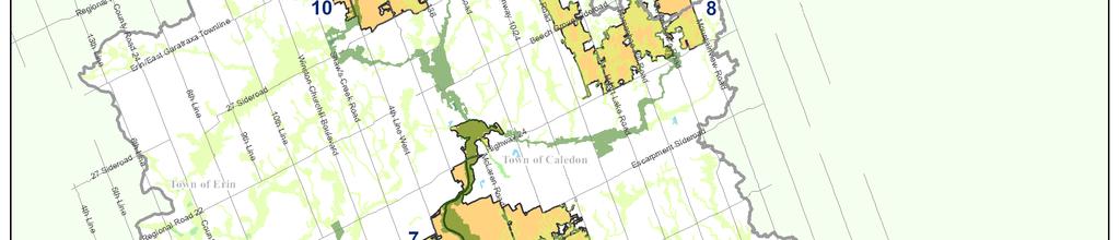
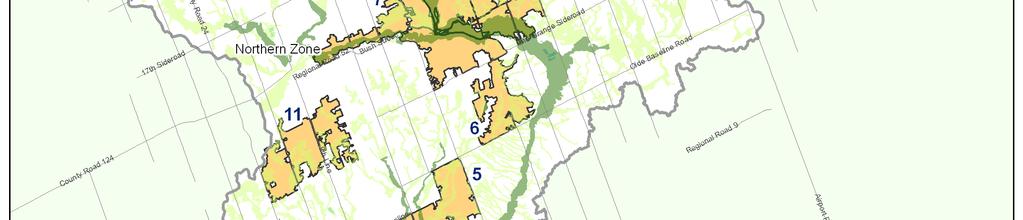
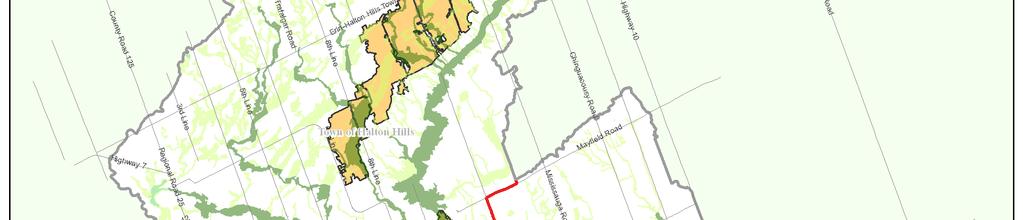
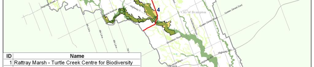
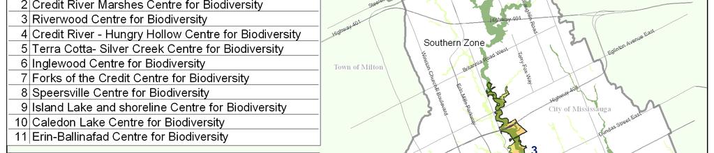
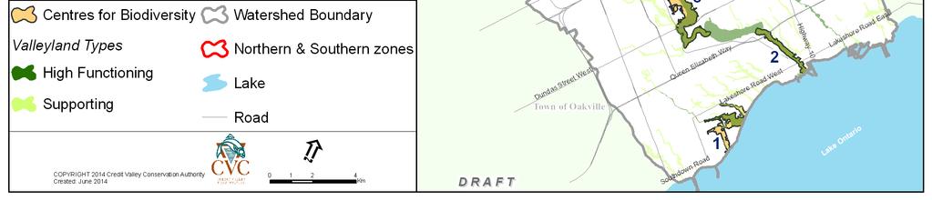
61 Figure 9. Centres for Biodiversity in the NHS, shown with valleyland linkages. Credit Valley Conservation 50
62 11. Credit River Watershed Natural Heritage System Components of the NHS are presented in the preceding chapters. Those components that can be mapped were combined to show the mapped NHS (Figure 8). The criteria text for the system supersedes the mapping. Minor boundary adjustments to natural heritage features and areas may occur based on updated site scale information resulting in slight changes to mapping. The natural heritage features and areas, including valleylands, wetlands, woodlands, aquatic habitat and Lake Ontario shoreline, significant wildlife habitat, habitat of endangered species and threatened species, Centres for Biodiversity, woodland interior improvement opportunities, and buffers (Table 2, Table 3) together create a functional natural heritage system that is likely to be sufficiently large, connected and resilient to provide continued biodiversity and ecosystem benefits to the watershed over the long term. The land cover types within the mapped NHS are shown in Figure 8 and shown in greater detail in Table 5. The total area occupied by the NHS is 45,404 ha. Terrestrial natural cover (as listed) in the system represents approximately 28% of total watershed area while non-natural terrestrial land cover such as agriculture, open space, or urban (also termed enhancement area) represents approximately 10% of total watershed area (Table 5). The area covered by the mapped NHS (excluding Lake Ontario but including other aquatic habitat) is 39% of total watershed area (Table 5). Credit Valley Conservation 51
63 Table 5. Statistics relating to the mapped NHS. Land cover and land use in the NHS Credit River Watershed Natural Heritage System Area occupied in hectares Area expressed as percent of total watershed area 1 Total terrestrial cover 36,238 38% Total terrestrial natural cover 26,735 28% Woodlands 2 21,360 23% Wetlands 2 6,382 7% Successional (cultural meadows and cultural thickets) 3,385 4% Other natural (e.g. bluffs, beach/bars) 32 0% Total Enhancement area 9,503 10% Agriculture 4,752 5% Open space 939 1% Urban 3,812 4% Total aquatic cover 3 9,166 n/a 1 Lake Ontario 8,258 n/a 1 Watercourses, water bodies excluding Lake Ontario 908 1% Total area in NHS excluding Lake Ontario 37,146 39% Total area in NHS including Lake Ontario 45,404 n/a 1 Percentages are always calculated as percentage of total watershed area excluding Lake Ontario, namely 94,891 ha and rounded to the nearest whole number. 2 Numbers for woodlands and wetlands are not additive as certain woodlands are also wetlands (i.e. treed swamps), and boundary features were not clipped to watershed boundary. 3 Aquatic cover is an underestimate of true aquatic cover, as most watercourses are mapped as line features in GIS and hence their area is not accounted for in area calculations. Credit Valley Conservation 52


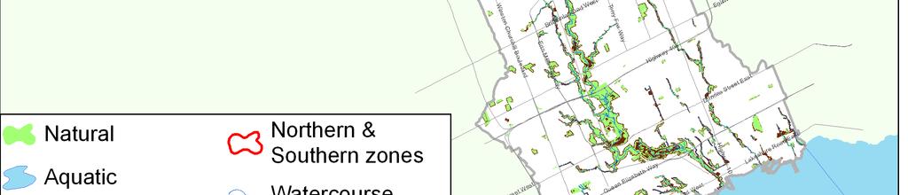
64 Figure 10. Mapped Credit River Watershed Natural Heritage System. Credit Valley Conservation 53
Credit Valley Conservation Natural Heritage System Strategy Phase 4
 Natural Heritage System Strategy Phase 4 Credit River Watershed Natural Heritage System Recommendations for Implementation Draft Report, May 2015 Report prepared by: Aviva Patel and Yvette Roy. Maps by
Credit Valley Conservation
 Credit Valley Conservation Strategic Plan Update 2008 Update and Compendium to 2006 Strategic Plan Contents About the Strategy Update 1 About Credit Valley Conservation Authority 2 Our Vision 4 CVC s Core
- :~MM~Si6~ER:)ETc:...
ETc:...") AltMo,-_t This Is ExhIbit u"3 u, referred to In the Affidavit of M..r \(. t-\c.~ sworn beforeme this z» "" day of M,l '0'''\ - :~MM~Si6~ER:)ETc:... REGION OF PEEL REGIONAL OFFICIAL PLAN REGIONAL OFFICIAL
AltMo,-_t This Is ExhIbit u"3 u, referred to In the Affidavit of M..r \(. t-\c.~ sworn beforeme this z» "" day of M,l '0'''\ - :~MM~Si6~ER:)ETc:... REGION OF PEEL REGIONAL OFFICIAL PLAN REGIONAL OFFICIAL
Credit Valley Conservation (CVC) Board of Directors. Chief Administrative Officer (CAO) Watershed Knowledge. Watershed Management
 Board of Directors. Chief Administrative Officer (CAO) Watershed Knowledge. Watershed Management") Credit Valley Conservation (CVC) Board of Directors Chief Administrative Officer (CAO) CVC Foundation Human Resources Corporate Watershed Knowledge Watershed Watershed Transformation Planning and Development
Credit Valley Conservation (CVC) Board of Directors Chief Administrative Officer (CAO) CVC Foundation Human Resources Corporate Watershed Knowledge Watershed Watershed Transformation Planning and Development
TO: The Chair and Members of December 5, 2014 Credit Valley Conservation NOTICE OF MEETINGS
 TO: The Chair and Members of December 5, 2014 Credit Valley Conservation NOTICE OF MEETINGS The 496 th meeting of Credit Valley Conservation will be held on Friday December 12, 2014 at 9:15am in the Boardroom
5.2-2 Progress Report and Future Outlook
 5.2-2 Progress Report and Future Outlook Presentation to Peel Regional Council By Deborah Martin-Downs June 22, 2017 5.2-3 Outline 2016 Highlights and 2017 Accomplishments to Date Climate Risk Methodology
LAND DEVELOPMENT AND PLANNING FORUM 2014 THE 2014 PROVINCIAL POLICY STATEMENT AND ENVIRONMENTAL PROTECTION
 LAND DEVELOPMENT AND PLANNING FORUM 2014 THE 2014 PROVINCIAL POLICY STATEMENT AND ENVIRONMENTAL PROTECTION MARY L. FLYNN-GUGLIETTI AND ANNIK FORRISTAL THE 2014 PROVINCIAL POLICY STATEMENT & ENVIRONMENTAL
PHASE 3 SUBWATERSHED MANAGEMENT STRATEGY AND IMPLEMENTATION
 PHASE 3 SUBWATERSHED MANAGEMENT STRATEGY AND IMPLEMENTATION 1. INTRODUCTION 1.1 Background The North West Brampton Subwatershed Study (SWS) process for the Huttonville Creek and Fletcher s Creek has been
Maitland Valley WATERSHED
 Maitland Valley WATERSHED Report Card 2018 Maitland Conservation has prepared this report card as a summary of the state of your forests, wetlands, and water resources. WHERE ARE WE? We are one of 36 Conservation
3. SHIRLEY S BROOK / WATTS CREEK SUBWATERSHED STUDY COMMITTEE RECOMMENDATION
 3. SHIRLEY S BROOK / WATTS CREEK SUBWATERSHED STUDY COMMITTEE RECOMMENDATION That Council endorse the Shirley s Brook/Watts Creek Subwatershed Study (September 1999) as the technical document to guide
Ten Steps to Implementing ROW LID
 connecting drops the Ten Steps to Implementing ROW LID UTRCA Symposium Low Impact Development: Opportunities for Municipalities Implementing LID on a Watershed Basis and Making a Difference: A 10 Step
Chapter 10 Natural Environment
 Chapter 10 Natural Environment Existing Conditions The Natural Environment Element addresses the protection, conservation, preservation, and restoration of the natural resources the Bayview Ridge Subarea,
Otonabee Region WATERSHED
 Otonabee Region WATERSHED Report Card 2018 Otonabee Conservation has prepared this report card as a summary of the state of your forests, wetlands, and water resources using data from 2012 to 2016. WHERE
Provincial Policy Statement 2014
 Natural Heritage Provincial Policy Statement 2014 NATURAL HERITAGE Nature is bountiful. It is also fragile and finite. Provincial Natural Heritage 0 Interest: Ontario s natural heritage resources are valuable
Provincial Policy Statement 2014 Training Aid
 This job aid has been developed for education and training purposes as a high-level summary of the policy changes in the PPS 2014. It should not be relied upon as a substitute for specialized legal or
ENVIRONMENTAL IMPACT STUDY GUIDELINES
 ENVIRONMENTAL IMPACT STUDY GUIDELINES Version 1 September, 2012 Section 1 Environmental Impact Study Overview TABLE OF CONTENTS What is an Environmental Impact Study (EIS) and What is its Purpose?.....................................
Natural Systems Planning Primer
 Natural Systems Planning Primer Lise.Guevremont@ottawa.ca Amy.Macpherson@ottawa.ca Land Use and Natural Systems Unit Planning and Growth Management November 2015 1 Welcome Policy Framework Development
WATERSHED. Maitland Valley. Report Card 201
 Maitland Valley WATERSHED Report Card 201 The Maitland Valley Conservation Authority has prepared this report card as a summary on the state of our forests, wetlands, surface water, and ground water resources.
TERRESTRIAL NATURAL HERITAGE SYSTEM TABLE OF CONTENTS
 TERRESTRIAL NATURAL HERITAGE SYSTEM TABLE OF CONTENTS 8.0 TERRESTRIAL NATURAL HERITAGE SYSTEM... 8-1 8.1 Watershed Objectives, Indicators and Targets... 8-2 8.2 Objectives of Technical Update... 8-2 8.3
Chapter 4 Watershed Goals and Objectives
 Chapter 4 Watershed Goals and Objectives Eight (8) long-term watershed goals have been developed by the NEW Watershed Advisory Group (WAG) after consideration of discussions held during monthly watershed
MURPHY DRAIN CATCHMENT
 The RVCA produces individual reports for 16 catchments in the Lower Rideau subwatershed. Using data collected and analysed by the RVCA through its watershed monitoring and land cover classification programs,
Community Benefits of Land Restoration
 Community Benefits of Land Restoration Introducing Green Infrastructure for Coastal Resilience Matt Fulda, Acting Director Monroe May 23 rd, 2017 Avery Point Campus, University of Connecticut Easton Trumbull
PEEL-CALEDON Significant Woodlands. Significant Wildlife Habitat. and STUDY DRAFT REPORT. for Public Comment
 PEEL-CALEDON Significant Woodlands and Significant Wildlife Habitat STUDY DRAFT REPORT for Public Comment OCTOBER 2008 PEEL - CALEDON SIGNIFICANT WOODLANDS AND SIGNIFICANT WILDLIFE HABITAT STUDY DRAFT
Provincial. Statement
 Provincial Statement This publication was produced by the Ministry of Municipal Affairs and Housing. For more copies of this document, in either English or French, please contact: Publications Ontario
Strategic Plan. Grand River Conservation Authority
 Grand River Conservation Authority Strategic Plan The Grand River Conservation Authority is a partnership of 39 municipalities created to manage water and natural resources for the benefit of the 960,000
ROPA 21B , , 4, W.H.S.
 Disclaimers: 1 This Office Consolidation is for information purposes only and the actual Council adopted ROPAs, Ministry approvals and Ontario Municipal Board decisions and approvals should be used for
VEGETATIVE, WATER, FISH AND WILDLIFE RESOURCES POLICIES
 VEGETATIVE, WATER, FISH AND WILDLIFE RESOURCES POLICIES The County will: GOALS AND OBJECTIVES 1.1 Conserve, Enhance, Protect, Maintain and Manage Vegetative, Water, Fish and Wildlife Resources Promote
Environment GOALS OVERVIEW
 Environment 10 GOALS 10 (A) Victoria s urban forests and public and private green spaces support healthy and diverse ecosystems. 10 (B) Victoria s Harbour, coastline, ponds and streams support healthy
ADDRESSING CLIMATE CHANGE ADAPTATION IN EASTERN ONTARIO APRIL 15, 2013
 ADDRESSING CLIMATE CHANGE ADAPTATION IN EASTERN ONTARIO APRIL 15, 2013 IPCC DEFINITION UNFCCC DEFINITION Climate change in Intergovernmental Panel on Climate Change (IPCC) usage refers to a change in the
PEEL-CALEDON Significant Woodlands. Significant Wildlife Habitat. and STUDY
 PEEL-CALEDON Significant Woodlands and Significant Wildlife Habitat STUDY FINAL REPORT JUNE 2009 PEEL - CALEDON SIGNIFICANT WOODLANDS AND SIGNIFICANT WILDLIFE HABITAT STUDY FINAL REPORT June 2009 Cover
Alberta s Biodiversity Policy DRAFT
 Alberta s Biodiversity Policy DRAFT Draft Alberta s Biodiversity Policy 1 Table of Contents Executive Summary... 3 1.0 Context and Background... 6 1.1 Policy Context... 6 1.2 Background... 6 1.2.1 What
Natural Resources and Climate Resiliency in Germantown
 Natural Resources and Climate Resiliency in Germantown Ingrid Haeckel, Andrew Meyer, and Elizabeth Murphy NYSDEC Hudson River Estuary Program and Cornell University Presentation to the Town of Germantown,
Toronto and Region Conservation 2017 Progress & 2018 Budget Peel Council
 Toronto and Region Conservation 2017 Progress & 2018 Budget Peel Council November 16, 2017 1 2 Input $4,248,000 44 Projects Activities Watershed 2017 Output Increased coverage of Flood Monitoring and Real
Draft Northwest Territories Conservation Areas Action Plan Frequently Asked Questions
 Draft Northwest Territories Conservation Areas Action Plan 2015-2020 Frequently Asked Questions 1. What is the draft Northwest Territories (NWT) Conservation Areas Action Plan 2015-2020? The draft Conservation
New Jersey Forest Stewardship Program Spatial Analysis Project Map Products And Data Layers Descriptions
 New Jersey Forest Stewardship Program Spatial Analysis Project 2007 Map Products And Data Layers Descriptions 01/07 NJ Forest Stewardship Program (FSP) Spatial Analysis Project (SAP) Methodology Project
AUMA Policy Paper 2013.A1
 AUMA Paper 2013.A1 AUMA Board of Directors Municipal Water on Wetlands WHEREAS in 2012 the AUMA Board of Directors issued the mandate of developing Municipal Water Policies and approved advancing polices
March 7, Background
 March 7, 2018 Protecting Water Ministry of Municipal Affairs and Housing Local Government and Planning Policy Division Provincial Planning Policy Branch 777 Bay Street, Floor 13 Toronto, ON M5G 2E5 RE:
General Plan Update Workshop 6 Agriculture, Conservation, & Open Space February 23, 2005
 General Plan Update Workshop 6 Agriculture, Conservation, & Open Space February 23, 2005 Municipal Services Agency Planning and Community Development Department Workshop Outline GPU Update Background &
LIVING LANDS Helping Land Trusts Conserve Biodiversity
 LIVING LANDS Helping Land Trusts Conserve Biodiversity Habitat Restoration: Information for Land Trusts What is Habitat Restoration? Habitat restoration is defined as the process of assisting the recovery
Policies, Procedures and Guidelines for the Administration of Ontario Regulation 155/06 and Land Use Planning Policy Document
 Policies, Procedures and Guidelines for the Administration of Ontario Regulation 155/06 and Land Use Planning Policy Document December 12, 2007 (Original NPCA Board Approval) December 9, 2009 (Housekeeping
PLANT AND ANIMAL DIVERSITY
 by the planning rule team as of. These ideas are for discussion purposes and do not What we want to achieve PLANT AND ANIMAL DIVERSITY The Forest Service is committed to protecting species and sustaining
DAKOTA COUNTY SOIL AND WATER CONSERVATION DISTRICT COMPREHENSIVE PLAN
 DAKOTA COUNTY SOIL AND WATER CONSERVATION DISTRICT COMPREHENSIVE PLAN 2011-2015 4100 220 th Street West, Suite 102 Farmington, MN 55024 651-480-7777 www.dakotacountyswcd.org I. INTRODUCTION A. Purpose
Environment & Conservation Introduction
 Environment & Conservation Introduction Anacortes is blessed with an abundance of natural beauty. Residents identify marine shorelines, streams, lakes, forested areas, and other natural features as defining
Applying Ecosystem Services to Collaborative Forest Management Elk River Public Meeting
 Applying Ecosystem Services to Collaborative Forest Management Elk River Public Meeting Nikola Smith Ecologist and Ecosystem Services Specialist U.S. Forest Service Port Orford City Hall February 2, 2017
Integrated Watershed Management Plan
 mighty peace watershed alliance Integrated Plan SUMMARY What is the Plan? The Mighty Peace Alliance (MPWA) supports the three goals of Alberta s Water for Life Strategy: safe secure drinking water, healthy
Chapter 5. Natural Features. Environmental Management Mode Land Resources Water Resources Air Quality Preparing for Climate Change
 Chapter 5 Natural Features Natural Features Environmental Management Mode Land Resources Water Resources Air Quality Preparing for Climate Change 5.1 NATURAL FEATURES BACKGROUND Maple Ridge encompasses
1. Executive Summary. Valley Branch and Trout Brook Watershed Grishma Shrestha
 1. Executive Summary Introduction This report intends to explore various environmental characteristics in the Valley Branch and Trout Brook watersheds, Washington County. The report primarily emphasizes
Preface. MNR # Queen s Printer for Ontario, 2012 ISBN (PRINT) ISBN (PDF)
 ISBN (PDF)") Preface In 2008, the inter-agency Drainage Act & Section 28 Regulations Team (DART) was established by the Ministry of Natural Resources (MNR) and the Ministry of Agriculture, Food and Rural Affairs (OMAFRA)
Preface In 2008, the inter-agency Drainage Act & Section 28 Regulations Team (DART) was established by the Ministry of Natural Resources (MNR) and the Ministry of Agriculture, Food and Rural Affairs (OMAFRA)
STREAM AND BUFFER AREA PROTECTION/RESTORATION
 STREAM AND BUFFER AREA PROTECTION/RESTORATION AMENDMENT OPTIONS TO STRENGTHEN POLICY IN HEADWATERS AREAS DRAFT SUBSEQUENT TO THE JANUARY 25, 2007 MEETING OF THE PLANNING COMMISSION ENVIRONMENT COMMITTEE
Managing Growth and Development
 Managing Growth and Development This technical document is part of a series of draft discussion papers created by Municipal Affairs staff and stakeholders to prepare for the Municipal Government Act Review.
Relationship to E Flows
 Relationship to E Flows Riparian Areas Influences groundwater/surface water relationships Provides filters to improve water quality Provides habitat for diverse flora and fauna Relationship to E Flows
Canada-Ontario Domestic Action Plan for Lake Erie Phosphorus Reduction. Agriculture Sector Working Group April 19, 2017
 Canada-Ontario Domestic Action Plan for Lake Erie Phosphorus Reduction Agriculture Sector Working Group April 19, 2017 Purpose Present an overview of the Canada-Ontario Draft Action Plan for Lake Erie
Sustainable Natural Environment Fish Habitat
 Town of Huntsville Official Plan Review - POLICY BACKGROUND PAPER Sustainable Natural Environment Fish Habitat BACKGROUND: Lakes, rivers, streams, ponds and many wetlands provide fish habitat. Intermittent
Why Do We Need Market Based Instruments to Conserve and Manage Alberta s Riparian Lands?
 Why Do We Need Market Based Instruments to Conserve and Manage Alberta s Riparian Lands? Judy Stewart, LL.M. Bow River Basin Council Workshop March 23, 2012 Outline What are riparian lands? Conserving
5. RECORDS REVIEW RESULTS
 Dufferin Wind Power Inc. 5. RECORDS REVIEW RESULTS As stated in Section 3, the wind turbines are located entirely within the Township of Melancthon, approximately 14 kilometres from the Town of Shelburne
Alberta Wetland Policy
 Table of Contents Alberta Wetland Policy Overview...2 Acknowledgements...3 Wetlands in Alberta...4 The Need for a New Provincial Wetland Policy...5 Policy Context...6 Policy Scope...7 Policy Goal and Outcomes...8
Climate Change and Watershed Management
 Climate Change and Watershed Management Moving to a Living City OSEE Conference 2009 by Chandra Sharma MCIP RRP Watershed Specialist About TRCA Focus of Presentation Urban Watershed and Climate Change
Theme: Supporting Sustainable Development and Urban Ecosystems
 Theme: Supporting Sustainable Development and Urban Ecosystems Action 1: What is a Climate Change Adaptation Plan and what does Natural Heritage have to do with it? A climate change adaptation plan examines
MEMORANDUM. Purpose: Background:
 MEMORANDUM To: MCWD Board of Managers From: Becky Christopher, Lead Planner CC: James Wisker, Director of Planning Date: January 11, 2016 Re: Mission, Vision, Values, Goals Purpose: At the January 14,
Katahdin Forest Management 2016 SFI Summary Audit Report
 Katahdin Forest Management 2016 SFI Summary Audit Report Introduction The SFI Program of Katahdin Forest Management of Millinocket, Maine has demonstrated continued conformance with the SFI 2015-2019 Standard
Cervid Ecological Framework June 2009
 Cette publication hautement spécialisée Cervid Ecological Framework n est disponible qu en anglais en vertu du Règlement 411/97 qui en exempte l application de la Loi sur les services en français. Pour
Ontario s Climate Change Adaptation Approach. Webinar Dates: November 16, 2017 November 23, 2017 November 30, 2017
 Ontario s Climate Change Adaptation Approach Webinar Dates: November 16, 2017 November 23, 2017 November 30, 2017 Agenda/Presentation Overview Climate Impacts Ontario s Response to Climate Change - A brief
Community Action Programs for the Environment
 Community Action Programs for the Environment We want to help protect endangered fish on our reserve from the effects of water pollution. Our school wants to share our cool ideas about sustainability with
3-13 Other Required Findings and Regulatory Compliance
 Affected Environment and Environmental Consequences 3-13 Other Required Findings and Regulatory Compliance 3-13.1 Short-term Uses and Long-term Productivity NEPA requires consideration of the relationship
Hello my name is Joy Loughry and I am with the groundwater technical unit of the Minnesota department of natural resources. Today I am going to talk
 Hello my name is Joy Loughry and I am with the groundwater technical unit of the Minnesota department of natural resources. Today I am going to talk about how the state of Minnesota manages its Water resources
Developing a Voluntary Carbon Offsets Program for Ontario
 Developing a Voluntary Carbon Offsets Program for Ontario Discussion Paper Ministry of the Environment and Climate Change November 2017 ontario.ca/climatechange Contents Purpose... 1 Climate change and
Performance Standard 6 V2
 Introduction 1. Performance Standard 6 recognizes that protecting and conserving biodiversity, maintaining ecosystem services, and sustainably managing living natural resources are fundamental to sustainable
TORCH LAKE TOWNSHIP WATER QUALITY ACTION PLAN
 TORCH LAKE TOWNSHIP WATER QUALITY ACTION PLAN Elk-River-Chain-of-Lakes Gaps Analysis Project The Watershed Center Grand Traverse Bay Tip of the Mitt Watershed Council Michigan Department of Natural Resources
THE FEDERAL POLICY ON WETLAND CONSERVATION. Government of Canada 1991
 THE FEDERAL POLICY ON WETLAND CONSERVATION Government of Canada 1991 Published by Authority of the Minister of Environment Minister of Supply and Services Canada, 1991 For more information on The Federal
SUMMARY REPORT. Environment and Sustainable Resource Development. Watershed Resiliency and Restoration Program Prioritization
 SUMMARY REPORT Environment and Sustainable Resource Development Watershed Resiliency and Restoration Program Prioritization January 2015 CONFIDENTIALITY AND COPYRIGHT This document is for the sole use
Manitoba s Submission Guidelines for Peatland Management Plans
 Manitoba s Submission Guidelines for Peatland Management Plans Peatland Management Guidebook Forestry and Peatlands Branch Manitoba Sustainable Development First Published: September 2017 Review by: 2022
The province has been divided into six Fire Management Zones based on common management objectives, land use, fire load, and forest ecology.
 Appendix A: Fire Management Zones & Zone Specific Direction The province has been divided into six Fire Management Zones based on common management objectives, land use, fire load, and forest ecology.
CONSERVING OUR FUTURE. A Modernized Conservation Authorities Act
 CONSERVING OUR FUTURE A Modernized Conservation Authorities Act TABLE OF CONTENTS MINISTER S MESSAGE 1 INTRODUCTION 2 OVERVIEW OF CONSERVATION AUTHORITIES AND THE CONSERVATION AUTHORITIES ACT REVIEW 4
The Ministry of Natural Resources and Forestry and Municipal Planning Lake Links
 The Ministry of Natural Resources and Forestry and Municipal Planning Lake Links October 21, 2017 Lyn Garrah District Planner MNRF 1 Kemptville Presentation Outline Ontario s Planning System MNRF s role
City of Ottawa. Environmental Impact Statement Guidelines. 2 nd Edition April 2012
 DOCUMENT 1 City of Ottawa Environmental Impact Statement Guidelines 2 nd Edition April 2012 Planning and Infrastructure Portfolio Planning and Growth Management Department Policy Development and Urban
Old Growth Policy for Ontario s Crown Forests
 Old Growth Policy for Ontario s Crown Forests FOREST POLICY SERIES Version 1 2003 Queen s Printer for Ontario Printed in Canada Single copies of this publication are available from: Natural Resources Information
Polluted Runoff and Land Conservation: What s the Connection?
 Polluted Runoff and Land Conservation: What s the Connection? Caroly Shumway, Ph.D. Executive Director, Merrimack River Watershed Council In partnership with NMCOG Overview Purpose Of This Talk Is To Convey
WATERSHED MANAGEMENT INITIATIVE: GOALS & IMPLEMENTATION OBJECTIVES, JULY 26, 1999
 WATERSHED MANAGEMENT INITIATIVE: GOALS & IMPLEMENTATION OBJECTIVES, JULY 26, 1999 The following table indicates the draft goals and objectives for the Santa Clara Basin WMI process. The overall objectives
Nova Scotia s Code of Forest Practice A Framework for the Implementation of Sustainable Forest Management
 Nova Scotia s Code of Forest Practice A Framework for the Implementation of Sustainable Forest Management Report FOR 2004-8 Table of Contents Introduction... 2 Code Format Code Review Applying the Code
Peel Climate Change Strategy Mitigation Strategy Report August 18, 2010 TABLE OF CONTENTS
 TABLE OF CONTENTS EXECUTIVE SUMMARY...i LIST OF ACRONYMS...ix 1.0 Introduction...1 1.1 About the Geographic Region of Peel... 2 2.0 BACKGROUND and OBJECTIVES...11 2.1 What is Mitigation?... 11 2.2 Objectives...
FOREST SERVICE MANUAL NATIONAL HEADQUARTERS (WO) WASHINGTON, DC
 WASHINGTON, DC") Page 1 of 12 FOREST SERVICE MANUAL NATIONAL HEADQUARTERS (WO) WASHINGTON, DC Interim Directive No.: 2020-2011-1 Effective Date: August 30, 2011 Duration: This interim directive expires on February 28,
Page 1 of 12 FOREST SERVICE MANUAL NATIONAL HEADQUARTERS (WO) WASHINGTON, DC Interim Directive No.: 2020-2011-1 Effective Date: August 30, 2011 Duration: This interim directive expires on February 28,
TRCA Environmental Impact Statement Guidelines
 Oct 2014 These guidelines are not meant to be exhaustive but present the typical requirements of the TRCA and are subject to change. INTRODUCTION 3 Purpose of an EIS 3 EIS REVIEW PROCESS 5 Step 1: Initial
Wetlands Project Guidance
 HABITAT Wetlands Project Guidance Stakeholder Informed Introduction Wetlands are lands saturated with water permanently or seasonally. Wetlands are typically defined by three characteristics: 1) The area
Chapter 13: Wildlife and Vegetation
 Chapter 13: Wildlife and Vegetation Introduction and Setting Nevada County contains an extremely wide range of plants, animals and habitat types. With topographic elevations ranging from 300 feet in the
Water and Watersheds. Data Maps Action
 Water and Watersheds Data Maps Action What is the Wildlife Action Plan? Restore rare wildlife and habitats. Keep common species common. 2015 Revision: Partners in Conservation Science 2015 Revision Data
by 2010 or beyond and what are the implications for the Convention on Biological Diversity?
 6. What are the prospects for reducing the rate of loss of biodiversity by 2010 or beyond and what are the implications for the Convention on Biological Diversity? Biodiversity will continue to decline
GRowing Outcomes in Watersheds (GROW) A home-grown ecological goods and services program for Manitoba
 A home-grown ecological goods and services program for Manitoba") GRowing Outcomes in Watersheds (GROW) A home-grown ecological goods and services program for Manitoba PUBLIC CONSULTATION DOCUMENT AUGUST 2017 MINISTERS MESSAGE Dear Manitobans, Manitoba s agriculture
GRowing Outcomes in Watersheds (GROW) A home-grown ecological goods and services program for Manitoba PUBLIC CONSULTATION DOCUMENT AUGUST 2017 MINISTERS MESSAGE Dear Manitobans, Manitoba s agriculture
Provincial Policy Statement 2014
 Provincial Policy Statement 2014 Planning for Prosperity and Sustainability Intersecting Challenges Integrated Solutions The Provincial Policy Statement (PPS) sets out Ontario s land use planning directions
Technical Rules: Assessment Report. Clean Water Act, 2006
 Technical Rules: Assessment Report Clean Water Act, 2006 November 20, 2008 Amended on: December 12, 2008 (administrative amendments) November 16, 2009 (EBR Posting Number EBRO10-7573) Clean Water Act,
Washington Department of Fish and Wildlife Climate Change Adaptation. Lynn Helbrecht Climate Change Coordinator
 Washington Department of Fish and Wildlife Climate Change Adaptation Lynn Helbrecht Climate Change Coordinator Washington Department of Fish and Wildlife Policy framework for adaptation Governors Executive
Municipal Stormwater Management Planning
 Municipal Stormwater Management Planning Christopher C. Obropta, Ph.D., P.E. Water Resources Extension Specialist with Rutgers Cooperative Extension Assistant Professor with Department of Environmental
B.C. Protected Areas Research Forum. Taking Nature s Pulse The Status of Biodiversity in British Columbia Putting Science into Action
 B.C. Protected Areas Research Forum Taking Nature s Pulse The Status of Biodiversity in British Columbia Putting Science into Action December 2, 2008 Who is Biodiversity BC? Ducks Unlimited Canada Environment
British Columbia s. VVater Act. Modernization. Policy Proposal on British Columbia s new Water Sustainability Act. December 2010
 British Columbia s VVater Act Modernization Policy Proposal on British Columbia s new Water Sustainability Act December 2010 British Columbia has a rich heritage in our lakes, rivers and streams. Linked
Integrated Regional. South Tahoe Public Utility District. Water Management Plan. July 2014 K/J Prepared By Kennedy/Jenks Consultants
 Tahoe-Sierra Integrated Regional Water Management Plan July 2014 K/J 1270036 Photo courtesy of Matthew Grimm South Tahoe Public Utility District Prepared By Kennedy/Jenks Consultants 10850 Gold Center
Oak Ridges Moraine Conservation Plan (2017)
") Oak Ridges Moraine Conservation Plan (2017) OAK RIDGES MORAINE CONSERVATION PLAN (2017) May 2017 Table of Contents Introduction 1 Context About the Oak Ridges Moraine Authority to Establish the Plan
Oak Ridges Moraine Conservation Plan (2017) OAK RIDGES MORAINE CONSERVATION PLAN (2017) May 2017 Table of Contents Introduction 1 Context About the Oak Ridges Moraine Authority to Establish the Plan
Rags to Riches - The RVCA Story of Science to Stewardship
 Rags to Riches - The RVCA Story of Science to Stewardship Rideau Valley Conservation Authority Eastern Ontario On Shield off Shield Large Urban population (Ottawa) Rideau Canal connecting St Lawrence to
Wildlife Conservation Strategy
 Wildlife Conservation Strategy Boise National Forest What is the Wildlife Conservation Strategy? The Boise National Forest is developing a Wildlife Conservation Strategy (WCS) in accordance with its Land
SUBJECT: WASHINGTON DEPARTMENT OF FISH AND WILDLIFE COMMENTS ON THE CITY OF MOSES LAKE DRAFT SHORELINE MASTER PROGRAM
 State of Washington Department of Fish and Wildlife Mailing Address: 1550 Alder St. NW, Ephrata, WA 98823 Main Office Location: Natural Resources Building, 1111 Washington St. SE Olympia WA July 9, 2014
West Fork White River Watershed Conservation Map Summaries. Prepared for the Beaver Watershed Alliance. By the Watershed Conservation Resource Center
 West Fork White River Watershed Conservation Map Summaries Prepared for the Beaver Watershed Alliance By the Watershed Conservation Resource Center November 2014 The Watershed Conservation Resource Center