Bowmanville Marsh. Enniskillen Conservation Area BOWMANVILLE/SOPER CREEK WATERSHED EXISTING CONDITIONS REPORT INTRODUCTION
|
|
|
- Howard Nelson
- 5 years ago
- Views:
Transcription


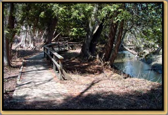

1 Bowmanville Marsh Enniskillen Conservation Area BOWMANVILLE/SOPER CREEK WATERSHED EXISTING CONDITIONS REPORT INTRODUCTION FINAL - December 2011
2 TABLE OF CONTENTS 1.0 INTRODUCTION STUDY AREA AND SCOPE METHODOLOGY CONCLUSION... 8 APPENDIX A - Bowmanville Soper Creek Watershed Management Plan Information... 9 LIST OF FIGURES Figure 1: Bowmanville/Soper Creek Watershed... 4 Figure 2: Bowmanville/Soper Creek Watershed Conservation Areas... 5
3 1.0 INTRODUCTION Central Lake Ontario Conservation Authority (CLOCA) is in the process of preparing updated watershed management plans for each of the major watersheds within its jurisdictional boundaries. The watershed plan for Oshawa Creek was the first to be completed. In the last few years, enactment of new provincial legislation and policies, like the Oak Ridges Moraine Conservation Act and Oak Ridges Moraine Conservation Plan, Clean Water Act, the 2005 Provincial Policy Statement (PPS), and source water protection initiatives have placed a greater emphasis on the need for watershed plans. In fact, the Oak Ridges Moraine Conservation Plan (ORMCP) requires watershed plans to be completed for all watersheds within the Moraine. The headwaters of the Lynde, Oshawa, Harmony, Black, Farewell, Bowmanville and Soper Creek watersheds originate from the Oak Ridges Moraine. The Bowmanville/Soper Creek watershed will be the fourth watershed plan in CLOCA s jurisdiction that will satisfy the requirements of the Oak Ridges Moraine Conservation Plan. 1
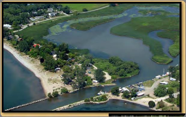
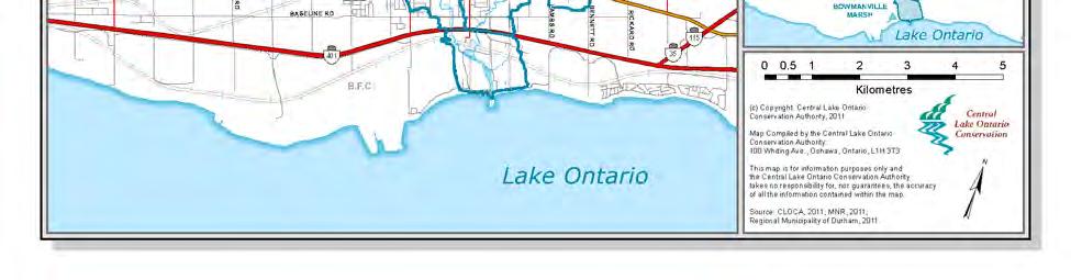
4 2.0 STUDY AREA AND SCOPE Bowmanville/Soper Creek and its tributaries drain a combined area of approximately 170 km 2 (Figure 1). This watershed is located entirely within the Regional Municipality of Durham and, with the exception of a very small area located in the Township of Scugog, this watershed flows through the Municipality of Clarington. The headwaters of the Bowmanville/Soper Creek originate in the Oak Ridges Moraine (ORM) and flow southerly towards Lake Ontario. Bowmanville Creek and its tributaries drain the western side of this watershed while the Soper Creek and its tributaries, drain the eastern half. The Soper Creek and the Bowmanville Creek intersect within the Provincially Significant Wetland (PSW) known as the Bowmanville Coastal Wetland Complex, just south of the Canadian National Railway before out-letting into Lake Ontario. Long Sault Conservation Area This watershed is situated on the eastern side of CLOCA. The lands north of this watershed drain to watersheds in Kawartha Region Conservation Authority (Blackstock Creek and East Cross Creek watersheds) and to the Wilmot Creek watershed in the Ganaraska Region Conservation Authority. The majority of the eastern boundary of the Soper Creek watershed lies beside the Wilmot Creek watershed. The southern portion of the Soper Creek watershed abuts the Bennett Creek watershed, one of CLOCA s smaller watersheds. The western limit of the Bowmanville Creek watershed is adjacent to 5 different watersheds. These are, from north to south, Oshawa Creek, Farewell Creek, Black Creek, Darlington Creek and Westside Creek watersheds. 2 Long Sault Conservation
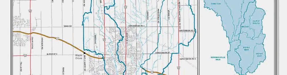
5 In addition to the ORM, the Lake Iroquois Beach represents another major landform within the watershed. The Lake Iroquois Beach crosses in an east-west direction through the centre of the watershed. Agriculture dominates this watershed, the exception being in the built up area of the Town of Bowmanville which exhibits a variety of urban land uses. While not all lands within Bowmanville are developed, they will be eventually urbanized. Natural cover is also quite prevalent within this watershed. There are six hamlets located within the Bowmanville/Soper Creek watershed. Enfield, Enniskillen, Haydon, and Tyrone are found within this watershed. While small portions of the hamlets of Burketon and Hampton are found beyond the limits of the watershed, the greater part of these hamlets are within the Bowmanville/Soper Creek watershed. The Conservation Authority owns more lands in this watershed than in any other within the Authority s jurisdiction. There are eight Conservation Areas, having a total of 1,416 ha of land within the watershed (Figure 2). Soper Headwater Tributary 3

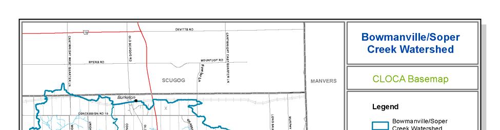
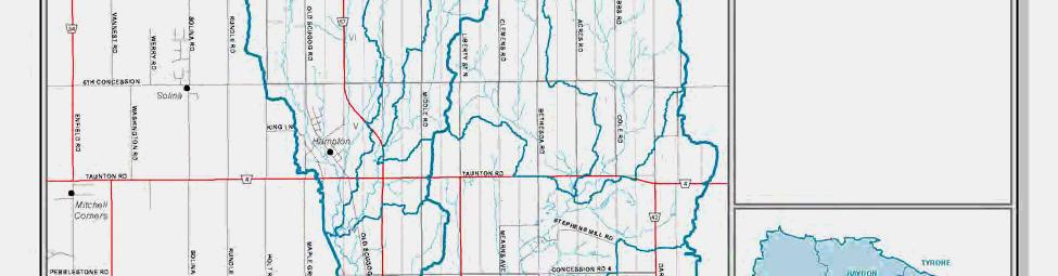
6 Figure 1: Bowmanville/Soper Creek Watershed 4


7 Farewell Creek subwatershed Taunton subwatershed Lou Wise Figure 2: Bowmanville/Soper Creek Watershed Conservation Areas 5
8 3.0 METHODOLOGY When dealing with the natural environment, it makes the most sense to make management decisions based upon nature s boundaries. A watershed is the area where all water drains towards one common water body. The size and scale of a watershed can range from that of a small tributary to the drainage area of the Great Lakes Basin or larger, an ocean. A watershed plan examines the health and functionality of a watershed and seeks to answer the question, what do we need to do to have a healthy watershed? To answer this question, the structural and functional parts of the watershed ecosystem and how they work together are examined. These components include environmental features such as landscapes, fish and wildlife habitats and communities, groundwater and surface water, as well as natural processes such as erosion and flooding. In addition to examination of the environmental features, cultural and historic use of the watershed by humans, plans for future growth and development within the watershed, are also examined. Having assessed the historic and existing conditions, an examination of the impacts that are predicted to occur due to future human and natural influences can be undertaken, providing an assessment of natural systems and a prediction of the watershed s future health. A completed watershed plan provides a solid foundation upon which to make environmentally sound decisions that will maintain and improve the watershed s future health. It also provides a basis on which planning decisions can be made having regard for potential cumulative impacts of change on all components of the ecosystem. With the passage of the Oak Ridges Moraine Conservation Plan (ORMCP), specific requirements have been set out that must be addressed when preparing a watershed plan. Many of these requirements are similar to the standard set of study components that are often used in watershed plans. However, the ORMCP has a stronger emphasis on ground and surface water quality/quantity and water budgets. In addition, the 2005 Provincial Policy Statement (PPS) requires planning authorities to identify those natural features that are necessary to the hydrological and ecological integrity of the watershed. Notwithstanding this, it is important to recognize that each watershed has its own unique characteristics and that a watershed study must be specifically designed in order to place necessary emphasis on the key characteristics of the individual watershed in addition to meeting legislative requirements. This watershed plan will be undertaken in 3 phases. The first phase, the Existing Conditions Report, provides an assessment of the state of the watershed by examining the following components: human heritage; green space; land use and policy; impervious surfaces; air quality; climate; physical geography; water budget; water temperature; surface water quality; surface water quantity; stormwater management; fluvial geomorphology; hydrogeology; aquatic habitat and fisheries; terrestrial natural heritage; and wetlands. Each component is summarized in its own stand-alone chapter, with 18 such chapters comprising the Existing Conditions report. This report will be the basis for establishing the current state of the Bowmanville/Soper Creek watershed. Each of these components has been prepared by technical experts drawing upon the current knowledge base and data that is available to CLOCA. It is anticipated that there will be gaps in the information. A critical gap analysis will be undertaken that will determine priorities in addressing these gaps in the next phase. 6
9 During this first phase, stakeholders and agencies have been notified of the release of the draft existing conditions report, comments requested, and notification of the upcoming public information session provided. This information was also posted on CLOCA s website and advertisements of the public information session posted in local newspapers. At the public information session the findings of the draft existing conditions report will be conveyed. This session will not only share CLOCA s information with the public, but has been designed to gain additional information and comments from residents, stakeholders and agencies. After this information session is held and public comments received, the existing conditions report will be refined and finalized. The second phase will be the development of alternative management options, management recommendations and the identification of preferred management options. Possible future impacts to the watershed and its resources will be identified and assessed, including consideration of the impact of population growth and the predicted effects of climate change. Management options will include recommendations for land development and recommendations for private and public land stewardship programs and agency initiatives. This phase will end with a public information session, seeking opinions from the public and stakeholders with respect to the management options and recommendations. Taking the input received during the second phase, the third and final phase will confirm the recommended management options and include an implementation and monitoring plan. The implementation plan will identify tools and programs that will support achieving the objectives of the recommended management option. Monitoring the effectiveness of the implemented recommendations is important to assess not only the outcome, but how the outcome was achieved. The recommended management options, implementation and monitoring plan will be presented to the public and stakeholders and will complete the watershed plan for the Bowmanville/Soper Creeks. Enniskillen Conservation Area 7


10 4.0 CONCLUSION It is recognized that watershed management plans are tools to be used to assist in making responsible management choices about watercourses and their surrounding environments. The plan s recommendations are to be implemented by the various watershed partners and stakeholders. Through the development of this plan, public awareness of water related issues in the face of increasing urbanization and resource demands will be increased. The watershed plan will also be used as a foundation for identification of stewardship projects and programs as the plan will identify where stewardship can be focused and the types of stewardship activities and programs that would provide the greatest benefit to the overall health of the watershed. Stephen's Gulch Conservation Area Bowmanville Marsh 8


11 APPENDIX A - Bowmanville Soper Creek Watershed Management Plan Information Watershed Facts The Bowmanville/Soper Creek Watershed covers an area of over 170 km 2 or 17,000 hectares. The watershed is located within the Municipality of Clarington. The headwaters of the Bowmanville/Soper Creek originate in the Oak Ridges Moraine and drain south to Lake Ontario. What is a Watershed Management Plan? Everything is connected to everything else This is no truer than within a watershed where the relationships between various resources, land uses, human activity and other factors including climate are inextricably linked. We all live within a watershed and our activities can have either a positive or negative effect on the water, natural spaces and health of the watershed and ultimately the health of your community. A watershed management plan examines the environment and assesses the relationships between these elements. From this information the foundation upon which to make environmentally sound decisions to maintain and improve a watershed s future health is derived. How are Plans developed? To start, the existing features and functions within the watershed are identified. Watershed targets comprised of goals and objectives depicting the desired conditions for the watershed are then established. These goals and objectives provide the direction for planning and management of the watershed. Alternative management options are developed and evaluated and a preferred management strategy is selected. To determine whether the strategies and recommendations of the management plan are effective in achieving the desired outcomes, it is critical to monitor various parameters (such as water quality or fish populations) before and after the plan s implementation. 9
Oshawa Creek Watershed Management Plan EXECUTIVE SUMMARY
 Oshawa Creek Watershed Management Plan EXECUTIVE SUMMARY The Central Lake Ontario Conservation Authority (CLOCA) has recognized the need to prepare comprehensive management strategies for all of its watersheds.
Natural Systems Planning Primer
 Natural Systems Planning Primer Lise.Guevremont@ottawa.ca Amy.Macpherson@ottawa.ca Land Use and Natural Systems Unit Planning and Growth Management November 2015 1 Welcome Policy Framework Development
3. SHIRLEY S BROOK / WATTS CREEK SUBWATERSHED STUDY COMMITTEE RECOMMENDATION
 3. SHIRLEY S BROOK / WATTS CREEK SUBWATERSHED STUDY COMMITTEE RECOMMENDATION That Council endorse the Shirley s Brook/Watts Creek Subwatershed Study (September 1999) as the technical document to guide
Credit Valley Conservation
 Credit Valley Conservation Strategic Plan Update 2008 Update and Compendium to 2006 Strategic Plan Contents About the Strategy Update 1 About Credit Valley Conservation Authority 2 Our Vision 4 CVC s Core
Ganaraska River Watershed Plan 2010
 Ganaraska River Watershed Plan 2010 GRCA Board Approval April 15, 2010 Resolution Number FA 15/10 Township of Hamilton The Ganaraska River Watershed Plan was written to provide guidance and recommendations
Credit Valley Conservation (CVC) Board of Directors. Chief Administrative Officer (CAO) Watershed Knowledge. Watershed Management
 Board of Directors. Chief Administrative Officer (CAO) Watershed Knowledge. Watershed Management") Credit Valley Conservation (CVC) Board of Directors Chief Administrative Officer (CAO) CVC Foundation Human Resources Corporate Watershed Knowledge Watershed Watershed Transformation Planning and Development
Credit Valley Conservation (CVC) Board of Directors Chief Administrative Officer (CAO) CVC Foundation Human Resources Corporate Watershed Knowledge Watershed Watershed Transformation Planning and Development
Ecological Services: Valuing Natural Areas within CLOCA
 Ecological Services: Valuing Natural Areas within CLOCA Action Plan #14 October 2017 CONTENTS 1. INTRODUCTION... 4 1.1 Purpose... 4 1.2 Context... 4 2. DISCUSSION... 5 2.1 What Are Ecological Goods and
Credit River Watershed Natural Heritage System Phase 3: Natural Heritage System methodology Draft summary report, May 2014
 Citation: CVC (Credit Valley Conservation) 2014. Credit Valley Conservation Natural Heritage System Strategy. Phase 3: Credit River Watershed Natural Heritage System.. 79p. For further inquiries regarding
5. RECORDS REVIEW RESULTS
 Dufferin Wind Power Inc. 5. RECORDS REVIEW RESULTS As stated in Section 3, the wind turbines are located entirely within the Township of Melancthon, approximately 14 kilometres from the Town of Shelburne
Top 10 Risks of the Clean Fill Dump Site
 Top 10 Risks of the Clean Fill Dump Site Definition in Uxbridge and Scugog Site Alteration By laws commercial fill operation means the placing or dumping of fill involving remuneration paid, or any other
AUMA Policy Paper 2013.A1
 AUMA Paper 2013.A1 AUMA Board of Directors Municipal Water on Wetlands WHEREAS in 2012 the AUMA Board of Directors issued the mandate of developing Municipal Water Policies and approved advancing polices
Otonabee Region WATERSHED
 Otonabee Region WATERSHED Report Card 2018 Otonabee Conservation has prepared this report card as a summary of the state of your forests, wetlands, and water resources using data from 2012 to 2016. WHERE
Our Water is Worth It!
 SUSTAINABLE MUNICIPAL WATER MANAGEMENT Our Water is Worth It! If this information is required in an accessible format, please contact 1-800-372-1102 ext.2029. 1 CONTENTS Page Section 2. Introduction 3.
Provincial Policy Statement 2014 Training Aid
 This job aid has been developed for education and training purposes as a high-level summary of the policy changes in the PPS 2014. It should not be relied upon as a substitute for specialized legal or
ENVIRONMENTAL IMPACT STUDY GUIDELINES
 ENVIRONMENTAL IMPACT STUDY GUIDELINES Version 1 September, 2012 Section 1 Environmental Impact Study Overview TABLE OF CONTENTS What is an Environmental Impact Study (EIS) and What is its Purpose?.....................................
Acknowledgements. Ganaraska Region Conservation Authority. Ontario Ministry of Natural Resources
 Acknowledgements The Wilmot Creek Fisheries Management Plan was written by Marc Desjardins (Ganaraska Region Conservation Authority) and Jeff McNeice (Ontario Ministry of Natural Resources), with input
Master Environmental Servicing Plan and Secondary Plan
 East Side Lands Stage 2 Master Environmental Servicing Plan and Secondary Plan Public Consultation Centre (PCC) December 5, 2016 Today s Agenda 6:00 pm 6:30 pm: Open House 6:30 pm 7:00 pm: Presentation
APPENDIX H Guidance for Preparing/Reviewing CEQA Initial Studies and Environmental Impact Reports
 APPENDIX H H.1 Guidance for Preparing and Reviewing CEQA Initial Studies Step 1: Consider the Project Characteristics as Provided by the Project Applicant Review the project application and draft plan
Cobourg Creek Watershed Plan 2008
 Cobourg Creek Watershed Plan 2008 GRCA Approval, March 19, 2009 Resolution Number FA 12/09 Township of Hamilton The Cobourg Creek Watershed Plan was written to provide guidance and recommendations for
Polluted Runoff and Land Conservation: What s the Connection?
 Polluted Runoff and Land Conservation: What s the Connection? Caroly Shumway, Ph.D. Executive Director, Merrimack River Watershed Council In partnership with NMCOG Overview Purpose Of This Talk Is To Convey
Watershed Management in Alberta Green Area
 Watershed Management in Alberta Green Area John Diiwu Alberta Outline What is the green area? Key land use activities Need for watershed management Some provincial policies Need for information and tools
2018 BUDGET PRESENTATION
 2018 BUDGET PRESENTATION To Peel Regional Council November 16, 2017 By Chief Administrative Officer Deborah Martin-Downs 1 Outline 2017 and 2018 Activities 2018 Budget Underfunded Budget Pressures 2 A
- :~MM~Si6~ER:)ETc:...
ETc:...") AltMo,-_t This Is ExhIbit u"3 u, referred to In the Affidavit of M..r \(. t-\c.~ sworn beforeme this z» "" day of M,l '0'''\ - :~MM~Si6~ER:)ETc:... REGION OF PEEL REGIONAL OFFICIAL PLAN REGIONAL OFFICIAL
AltMo,-_t This Is ExhIbit u"3 u, referred to In the Affidavit of M..r \(. t-\c.~ sworn beforeme this z» "" day of M,l '0'''\ - :~MM~Si6~ER:)ETc:... REGION OF PEEL REGIONAL OFFICIAL PLAN REGIONAL OFFICIAL
Canada-Ontario Domestic Action Plan for Lake Erie Phosphorus Reduction. Agriculture Sector Working Group April 19, 2017
 Canada-Ontario Domestic Action Plan for Lake Erie Phosphorus Reduction Agriculture Sector Working Group April 19, 2017 Purpose Present an overview of the Canada-Ontario Draft Action Plan for Lake Erie
Guidelines for the Implementation of Ontario Regulation 179/06
 A Watershed for Life Guidelines for the Implementation of Ontario Regulation 179/06 LSRCA Board of Directors Meeting March 27, 2015 Beverley G. Booth, MSc., MCIP, RPP Manager, Planning, Regulations and
ADDRESSING CLIMATE CHANGE ADAPTATION IN EASTERN ONTARIO APRIL 15, 2013
 ADDRESSING CLIMATE CHANGE ADAPTATION IN EASTERN ONTARIO APRIL 15, 2013 IPCC DEFINITION UNFCCC DEFINITION Climate change in Intergovernmental Panel on Climate Change (IPCC) usage refers to a change in the
Climate Change and Watershed Management
 Climate Change and Watershed Management Moving to a Living City OSEE Conference 2009 by Chandra Sharma MCIP RRP Watershed Specialist About TRCA Focus of Presentation Urban Watershed and Climate Change
Chapter 10 Natural Environment
 Chapter 10 Natural Environment Existing Conditions The Natural Environment Element addresses the protection, conservation, preservation, and restoration of the natural resources the Bayview Ridge Subarea,
Ten Steps to Implementing ROW LID
 connecting drops the Ten Steps to Implementing ROW LID UTRCA Symposium Low Impact Development: Opportunities for Municipalities Implementing LID on a Watershed Basis and Making a Difference: A 10 Step
Gray s Creek. Gray s Creek
 Gray s Creek 1 Grades F + Forest Conditions B Wetland Conditions C - Surface Water Quality This Watershed Report Card outlines the environmental information for the Gray s Creek watershed as of 2017. The
TERMS OF REFERENCE SOUTHWEST INTERLAKE INTEGRATED WATERSHED MANAGEMENT PLAN
 TERMS OF REFERENCE SOUTHWEST INTERLAKE INTEGRATED WATERSHED MANAGEMENT PLAN March 17, 2014 TABLE OF CONTENTS 1.0 INTRODUCTION Page 1 PURPOSE PLANNING PROCESS PRINCIPLES OF INTEGRATED WATERSHED MANAGEMENT
March 7, Background
 March 7, 2018 Protecting Water Ministry of Municipal Affairs and Housing Local Government and Planning Policy Division Provincial Planning Policy Branch 777 Bay Street, Floor 13 Toronto, ON M5G 2E5 RE:
LAND DEVELOPMENT AND PLANNING FORUM 2014 THE 2014 PROVINCIAL POLICY STATEMENT AND ENVIRONMENTAL PROTECTION
 LAND DEVELOPMENT AND PLANNING FORUM 2014 THE 2014 PROVINCIAL POLICY STATEMENT AND ENVIRONMENTAL PROTECTION MARY L. FLYNN-GUGLIETTI AND ANNIK FORRISTAL THE 2014 PROVINCIAL POLICY STATEMENT & ENVIRONMENTAL
Credit Valley Conservation Natural Heritage System Strategy Phase 4
 Natural Heritage System Strategy Phase 4 Credit River Watershed Natural Heritage System Recommendations for Implementation Draft Report, May 2015 Report prepared by: Aviva Patel and Yvette Roy. Maps by
Report Card on the. Key funding support generously provided by the Friends of the Greenbelt Foundation.
 Report Card on the Environmental Health of the Oak Ridges Moraine and AdjACEnt Greenbelt Lands This report card was prepared by the Conservation Authorities Moraine Coalition (CAMC) to provide science-based
MURPHY DRAIN CATCHMENT
 The RVCA produces individual reports for 16 catchments in the Lower Rideau subwatershed. Using data collected and analysed by the RVCA through its watershed monitoring and land cover classification programs,
TORCH LAKE TOWNSHIP WATER QUALITY ACTION PLAN
 TORCH LAKE TOWNSHIP WATER QUALITY ACTION PLAN Elk-River-Chain-of-Lakes Gaps Analysis Project The Watershed Center Grand Traverse Bay Tip of the Mitt Watershed Council Michigan Department of Natural Resources
C Fish Lake C Rice Lake C Mud Lake C Weaver Lake C Elm Creek*
 IV. PROBLEMS AND CORRECTIVE ACTIONS Outlined below is an assessment of existing and potential water resource-related issues that are known at this time. These issues have been identified based on Commission
Guidelines for the Preparation of Environmental Impact Studies
 City of Guelph Guidelines for the Preparation of Environmental Impact Studies Version 1 June 2017 Foreword and acknowledgements This guideline has been developed by the City of Guelph to support and assist
TO: The Chair and Members of December 5, 2014 Credit Valley Conservation NOTICE OF MEETINGS
 TO: The Chair and Members of December 5, 2014 Credit Valley Conservation NOTICE OF MEETINGS The 496 th meeting of Credit Valley Conservation will be held on Friday December 12, 2014 at 9:15am in the Boardroom
Lower Rideau Watershed Strategy Executive Summary
 Lower Rideau Watershed Strategy Prepared For: Prepared By: Robinson Consultants Inc. Consulting Engineers Aquafor Beech Limited Our Project No.02048 September 2005 Introduction Since the 1970s, numerous
Integrated Watershed Management Plan
 mighty peace watershed alliance Integrated Plan SUMMARY What is the Plan? The Mighty Peace Alliance (MPWA) supports the three goals of Alberta s Water for Life Strategy: safe secure drinking water, healthy
Watersheds. A river is the report card for its watershed. Alan Levere. Arizona Water Issues 2010 The University of Arizona HWR203 1
 Watersheds A river is the report card for its watershed. Alan Levere 1 What separates watersheds? How do you identify watershed boundaries? Drainage Divides River Networks boto.ocean.washington.edu/gifs/purus.gif
GENERAL SPECIFICATION FOR ENVIRONMENTAL PROTECTION FOR CONSTRUCTION IN WATERBODIES AND ON WATERBODY BANKS
 ONTARIO PROVINCIAL STANDARD SPECIFICATION METRIC OPSS.PROV 182 NOVEMBER 2012 GENERAL SPECIFICATION FOR ENVIRONMENTAL PROTECTION FOR CONSTRUCTION IN WATERBODIES AND ON WATERBODY BANKS TABLE OF CONTENTS
WATERSHED. Maitland Valley. Report Card 201
 Maitland Valley WATERSHED Report Card 201 The Maitland Valley Conservation Authority has prepared this report card as a summary on the state of our forests, wetlands, surface water, and ground water resources.
Strategic Plan. Grand River Conservation Authority
 Grand River Conservation Authority Strategic Plan The Grand River Conservation Authority is a partnership of 39 municipalities created to manage water and natural resources for the benefit of the 960,000
The following potential environmental receptors and impacts form the basis of TRCA s review under Ontario Regulation 166/06 and the Fisheries Act:
 TRCA Technical Guidelines for the Development of Environmental Management Plans for Dewatering September 2013 Rationale: The Technical Guidelines for the Development of Environmental Management Plans for
Shell Quest Carbon Capture and Storage Project. Shell Canada Limited
 SCREENING SCOPING DOCUMENT For the proposed Shell Quest Carbon Capture and Storage Project Shell Canada Limited Prepared by: Canadian Environmental Assessment Agency Natural Resources Canada Fisheries
Sustainable Natural Environment Fish Habitat
 Town of Huntsville Official Plan Review - POLICY BACKGROUND PAPER Sustainable Natural Environment Fish Habitat BACKGROUND: Lakes, rivers, streams, ponds and many wetlands provide fish habitat. Intermittent
DEVELOPMENT AND INTERFERENCE WITH WETLANDS AND WATERCOURSES REGULATION - POLICIES AND PROCEDURES MANUAL For Planning Act Applications
 DEVELOPMENT AND INTERFERENCE WITH WETLANDS AND WATERCOURSES REGULATION - POLICIES AND PROCEDURES MANUAL For Planning Act Applications REVISED JANUARY, 2017 (administrative edits) Executive Board Motions
ENVIRONMENT ACT TERMS OF REFERENCE NOVA SCOTIA DEPARTMENT OF TRANSPORTATION AND PUBLIC WORKS. Beaver Bank Bypass
 ENVIRONMENT ACT TERMS OF REFERENCE NOVA SCOTIA DEPARTMENT OF TRANSPORTATION AND PUBLIC WORKS Beaver Bank Bypass Highway 101 to the Beaver Bank Road Halifax County, NS NOVA SCOTIA DEPARTMENT OF THE ENVIRONMENT
PHASE 3 SUBWATERSHED MANAGEMENT STRATEGY AND IMPLEMENTATION
 PHASE 3 SUBWATERSHED MANAGEMENT STRATEGY AND IMPLEMENTATION 1. INTRODUCTION 1.1 Background The North West Brampton Subwatershed Study (SWS) process for the Huttonville Creek and Fletcher s Creek has been
2016 Proposed Budget. April 29, 2016
 April 29, 2016 TABLE OF CONTENTS Introduction... 3 2016-2020 Strategic Plan... 3 Member Municipalities and Board of Directors... 6 Budget Assumptions... 7 Staffing... 7 2016 Budget - Strategic Priorities...
5.2-2 Progress Report and Future Outlook
 5.2-2 Progress Report and Future Outlook Presentation to Peel Regional Council By Deborah Martin-Downs June 22, 2017 5.2-3 Outline 2016 Highlights and 2017 Accomplishments to Date Climate Risk Methodology
Environmental Impact Statement for the Slave Falls Tramway Conversion Project
 Environmental Impact Statement for the Slave Falls Tramway Conversion Project Prepared for Submitted by 41844.101 March 2008 ENVIRONMENTAL IMPACT STATEMENT FOR THE SLAVE FALLS TRAMWAY CONVERSION PROJECT
Top 10 Risks of the Clean Fill Dump Site
 Top 10 Risks of the Clean Fill Dump Site Definition in Uxbridge and Scugog Site-Alteration By-laws commercial fill operation -means the placing or dumping of fill involving remuneration paid, or any other
Hamilton Harbour. Area of Concern Status of Beneficial Use Impairments September 2010
 Hamilton Harbour Area of Concern Status of Beneficial Use Impairments September 2010 Hamilton Harbour is a 2150-ha bay located at the western tip of Lake Ontario. The Area of Concern covers about 500 km
A Freshwater Blueprint for Maritime Canada
 A Freshwater Blueprint for Maritime Canada Union of Nova Scotia Municipalities (UNSM) November 8 th, 2017 William Millar Aquatic Conservation Biologist william.millar@natureconservancy.ca Craig Smith Conservation
Watershed Management Planning and Terms of Reference Workshop
 Watershed Management Planning and Terms of Reference Workshop Jay S. White, M.Sc., P.Biol. and Amanda Cooper, B.Sc. Aquality Environmental Consulting Ltd. February 20, 2014 Overview of Presentation Watershed
CHESAPEAKE BAY COMPREHENSIVE WATER RESOURCES AND RESTORATION PLAN. Habitat GIT Meeting 9 May 2017
 CHESAPEAKE BAY COMPREHENSIVE WATER RESOURCES AND 255 255 255 237 237 237 0 0 0 217 217 217 163 163 163 200 200 200 131 132 122 239 65 53 80 119 27 RESTORATION PLAN 110 135 120 252 174.59 112 92 56 62 102
SECTION 3: Water, Wetlands and Waterways
 SECTION 3: Water, Wetlands and Waterways KEY PRIORITY To ensure protection of water quality and quantity for use by residents, the commercial sector and ecosystems, through integrated consultation, planning,
Lower Mission Creek Watershed Status Survey 2002
 Lower Mission Creek Watershed Status Survey 2002 Prepared For: Mosquito Creek Stewardship Society Prepared By: Fernando F. Junqueira, Ph.D. August 16, 2002 North Vancouver, August 16, 2002 ENVIRONMENTAL
Habitat Grant Projects Clinton River Watershed
 Habitat Grant Projects Clinton River Watershed L Y N N E S E Y M O U R E N V I R O N M E N T A L E N G I N E E R O F F I C E O F T H E M A C O M B C O U N T Y P U B L I C W O R K S C O M M I S S I O N
Preface. MNR # Queen s Printer for Ontario, 2012 ISBN (PRINT) ISBN (PDF)
 ISBN (PDF)") Preface In 2008, the inter-agency Drainage Act & Section 28 Regulations Team (DART) was established by the Ministry of Natural Resources (MNR) and the Ministry of Agriculture, Food and Rural Affairs (OMAFRA)
Preface In 2008, the inter-agency Drainage Act & Section 28 Regulations Team (DART) was established by the Ministry of Natural Resources (MNR) and the Ministry of Agriculture, Food and Rural Affairs (OMAFRA)
Climate Data Training Session April 26, 2017 Ontario Science Centre
 Adaptive Management To Address Climate Change Uncertainty in EA Process A Case Study of the Don Mouth Naturalization and Port Lands Flood Protection Project EA (DMNP EA) Climate Data Training Session April
Water Budgets - Source Water Protection and Beyond
 Water Budgets - Source Water Protection and Beyond Donald Ford, P.Geo 1, Gayle Soo Chan, P.Geo 2 1 Manager, Geoenvironmental, Toronto and Region Conservation Authority, Toronto, Ontario, Canada 2 Director
ENVIRONMENTAL IMPACT STUDY (EIS) TERMS OF REFERENCE & SUBMISSION STANDARDS
 TERMS OF REFERENCE & SUBMISSION STANDARDS") The Otonabee Region Conservation Authority 250 Milroy Drive, Peterborough, Ontario, K9H 7M9 Phone: 705-745-5791 Fax: 705-745-7488 email: otonabeeca@otonabeeconservation.com ENVIRONMENTAL IMPACT STUDY (EIS)
The Otonabee Region Conservation Authority 250 Milroy Drive, Peterborough, Ontario, K9H 7M9 Phone: 705-745-5791 Fax: 705-745-7488 email: otonabeeca@otonabeeconservation.com ENVIRONMENTAL IMPACT STUDY (EIS)
Policies, Procedures and Guidelines for the Administration of Ontario Regulation 155/06 and Land Use Planning Policy Document
 Policies, Procedures and Guidelines for the Administration of Ontario Regulation 155/06 and Land Use Planning Policy Document December 12, 2007 (Original NPCA Board Approval) December 9, 2009 (Housekeeping
Canada-Ontario Agreement. on Great Lakes Water Quality and Ecosystem Health
 Canada-Ontario Agreement on Great Lakes Water Quality and Ecosystem Health 2014 Cover Photos: Main Image: Photo: Thinkstock Map Environment Canada Published by Environment Canada and the Ontario Ministry
A Salt Marsh Advancement Zone Assessment of West Haven, Connecticut
 A Salt Marsh Advancement Zone Assessment of West Haven, Connecticut Front cover image: Open space and unprotected parcels critical to the conservation of marsh advancement corridors in West Haven; from
Detroit River. Area of Concern Canadian Section. Status of Beneficial Use Impairments September 2010
 The Detroit River is a major navigation corridor of the Great Lakes, extending 51 km from Lake St. Clair to Lake Erie. Its watershed, which covers about 2000 km 2 (200 000 ha) on both sides of the international
City of Ottawa. Environmental Impact Statement Guidelines. 2 nd Edition April 2012
 DOCUMENT 1 City of Ottawa Environmental Impact Statement Guidelines 2 nd Edition April 2012 Planning and Infrastructure Portfolio Planning and Growth Management Department Policy Development and Urban
5. Water Budget Implementation Procedures
 5. Water Budget Implementation Procedures 5.1 General The purpose of the watershed level water budget is to determine the volume of surface and groundwater available for the benefit of both human populations
Outcomes. Kelly Karll-SEMCOG Margaret Barondess - MDOT
 Eco-Logical: I-75 Corridor I-75 Conservation Transportation Action Planning in to Monroe Achieve County: Multiple Stormwater Environmental Considerations Outcomes Kelly Karll-SEMCOG Karll@semcog.org Margaret
Headwater Wetland Restoration Techniques The Wetland Drain Restoration Project
 Headwater Wetland Restoration Techniques The Wetland Drain Restoration Project Tools for Managing Small Drainage Features in Rural Landscapes Workshop, March 5, 2014 Dave Richards, Partnership Specialist,
FLOW AND PRECIPITATION MONITORING
 FLOW AND PRECIPITATION MONITORING A Discussion Paper in Support of the Development of A Regional Watershed Monitoring Network Prepared By: The Toronto and Region Conservation Authority September, 2000
Chapter 5. Natural Features. Environmental Management Mode Land Resources Water Resources Air Quality Preparing for Climate Change
 Chapter 5 Natural Features Natural Features Environmental Management Mode Land Resources Water Resources Air Quality Preparing for Climate Change 5.1 NATURAL FEATURES BACKGROUND Maple Ridge encompasses
Provincial. Statement
 Provincial Statement This publication was produced by the Ministry of Municipal Affairs and Housing. For more copies of this document, in either English or French, please contact: Publications Ontario
Information Requirements Table for Liquid Waste
 Applicant Summary Tracking # Authorization # Applicant / Facility Name Ministry of Environment Prepared by: Title Date The Information Requirements Table (IRT) for Liquid Waste is a tool used by Ministry
A Salt Marsh Advancement Zone Assessment of Clinton, Connecticut
 A Salt Marsh Advancement Zone Assessment of Clinton, Connecticut Front cover image: Open space and unprotected parcels critical to the conservation of marsh advancement corridors in Clinton; from the accompanying
Suffolk Downs Redevelopment. Appendix G: Stormwater Management Supporting Documentation
 Suffolk Downs Redevelopment Expanded PNF Appendix G: Stormwater Management Supporting Documentation Suffolk Downs Redevelopment Phase 1 Stormwater Management Report Boston, Massachusetts 285402RP004 TABLE
PENDER HARBOUR DOCK MANAGEMENT PLAN
 PENDER HARBOUR DOCK MANAGEMENT PLAN 1.0 INTENT OF DOCK MANAGEMENT PLAN The Pender Harbour Dock Management Plan (the DMP) is an instrument of policy that provides guidance in relation to docks authorized
Comparative Evaluation Option #1 & Option #2
 Comparative Evaluation Option #1 & Option #2 Option #1 Existing Landfill Approx. 47 metres/14 stories Proposed Layout Approx. 31 metres/9.5 stories Option #2 Existing Landfill Approx. 47 metres/14 stories
Lake Simcoe Region Conservation Authority
 Lake Simcoe Region Conservation Authority Guidelines for the Implementation of Ontario Regulation 179/06 Development, Interference with Wetlands and Alteration to Shorelines and Watercourses Regulation
this report has been formatted for double-sided printing
 Credit Valley Conservation Credit Valley Conservation Stormwater Management Criteria August 2012 this report has been formatted for double-sided printing STORMWATER MANAGEMENT CRITERIA iii Acknowledgements
Oak Ridges Moraine Conservation Plan
 Oak Ridges Moraine Conservation Plan INTRODUCTION Oak Ridges Moraine Conservation Plan TABLE OF CONTENTS About This Plan... 1 Authority to Establish the Plan... 3 Smart Growth and the Oak Ridges Moraine...
Comprehensive Study Scoping Document. for Lower Mattagami Hydroelectric Complex Redevelopment CEAR Reference Number:
 Comprehensive Study Scoping Document for Lower Mattagami Hydroelectric Complex Redevelopment CEAR Reference Number: 07-03-26302 Prepared pursuant to Subsection 21(1) of the Canadian Environmental Assessment
Why Do We Need Market Based Instruments to Conserve and Manage Alberta s Riparian Lands?
 Why Do We Need Market Based Instruments to Conserve and Manage Alberta s Riparian Lands? Judy Stewart, LL.M. Bow River Basin Council Workshop March 23, 2012 Outline What are riparian lands? Conserving
Municipal Class Environmental Assessment for Pottersburg Creek Slope Stability Study South of Hamilton Road, Schedule B
 Municipal Class Environmental Assessment for Pottersburg Creek Slope Stability Study South of Hamilton Road, Schedule B February 13, 2013 Municipal Class EA Process We are here Purpose and Objective of
PROPOSED PIPELINES TO SERVE THE COMMUNITY OF FENELON FALLS: ENVIRONMENTAL REPORT
 1.0 INTRODUCTION 1.1 PROJECT DESCRIPTION Enbridge Gas Distribution Inc. ("Enbridge") is proposing to construct up to a total of approximately 37 kilometres (km) of natural gas pipelines at different nominal
2016 Report on Actions
 2016 Report on Actions Partners Municipalities of the Grand River watershed including: - Township of Centre Wellington - City of Guelph - Regional Municipality of Waterloo - City of Waterloo - City of
Ottawa-Trussler Area Sewage Facility Class Environmental Assessment
 Welcome to the Ottawa-Trussler Area Sewage Facility Class Environmental Assessment Public Open House May 7, 2013 September 25, 2013 Welcome The purpose of this second Public Open House is to: Present the
Wisconsin s Green Fire: Voices for Conservation
 Analysis of proposal to remove state regulatory oversight of non-federal wetlands in legislation: AB547 / SB600 December 18, 2017 Legislation Description: The following is an excerpt of the analysis of
C&B Alberta Solar Development ULC
 Decision 22296-D01-2017 Hays Solar Power Plant June 7, 2017 Alberta Utilities Commission Decision 22296-D01-2017 Hays Solar Power Plant Proceeding 22296 Application 22296-A001 June 7, 2017 Published by
Appendix B. Commitments made in the Approved Terms of Reference
 Appendix B Commitments made in the Approved Terms of Reference Approved Terms of Reference Requirements and How They Were in the 1. The study area considered for the new landfill footprint at the West
Corporate Environmental Water Stewardship Go Green. Todd Reeve October 17, 2017
 Corporate Environmental Water Stewardship Go Green Todd Reeve October 17, 2017 Freshwater & Business Risk #1 threat (World Economic Forum 2016) 2/3 rd of companies report water as substantive risk* 44%
Rags to Riches - The RVCA Story of Science to Stewardship
 Rags to Riches - The RVCA Story of Science to Stewardship Rideau Valley Conservation Authority Eastern Ontario On Shield off Shield Large Urban population (Ottawa) Rideau Canal connecting St Lawrence to
Environment GOALS OVERVIEW
 Environment 10 GOALS 10 (A) Victoria s urban forests and public and private green spaces support healthy and diverse ecosystems. 10 (B) Victoria s Harbour, coastline, ponds and streams support healthy
Grand River Conservation Authority
 Grand River Conservation Authority Report number: GM-02-17-24 Date: February 24, 2017 To: Subject: Management Committee Water Quality Conditions Report Recommendation: That Report GM-02-17-24- Water Quality
Debrob Investments Limited FUNCTIONAL SERVICING REPORT DRAFT PLAN OF SUBDIVISION, CITYVIEW DRIVE CITY OF GUELPH
 JULY 2013 DOCUMENT CONTROL Client: Project Name: Report Title: IBI Reference: 25528 Cityview Drive Version: JULY 2013 Digital Master: Originator: Reviewer: Authorization: [File Location] Scott MacDonald,