What is the Vadose Zone? Why Do We Care? Tiffany Messer Assistant Professor Biological Systems Engineering School of Natural Resources University of
|
|
|
- Alexia Logan
- 5 years ago
- Views:
Transcription


1 What is the Vadose Zone? Why Do We Care? Tiffany Messer Assistant Professor Biological Systems Engineering School of Natural Resources University of Nebraska-Lincoln
2 Learning Objectives History of Vadose Zone Hydrology What is the vadose zone? Why do we care? Soil Basics Are there differences between soils? If so, how do we identify those differences? Water Movement What is preferential flow? What is a vadose lag time? Nitrate Movement Are common assumptions correct? Is groundwater more vulnerable dependent on depth or rainfall timing?
3 History of Vadose Zone Hydrology


4 What is the vadose zone? The vadose zone, also termed the unsaturated zone, extends from the top of the ground surface to the water table. The word Vadose means "shallow in Latin.


5 How far does soil science go back? A BC B. 460 BC C AD D. 180 AD
6 History of the Soil Science Samaria (1700 BC) Instructions on the preparation of land and planting of grain crops in the Euphrates River valley Democritus ( BC) plant growth involved the cycling of indestructible elements Aristotle ( BC) Taught that plants absorbed their nutrients from humus through the root system Homer to Odysseus using manure as fertilizer The Bible 1 Sam. 13:20- Israelites to sharpen what would be considered their agricultural implements Deut. 11: irrigation practices

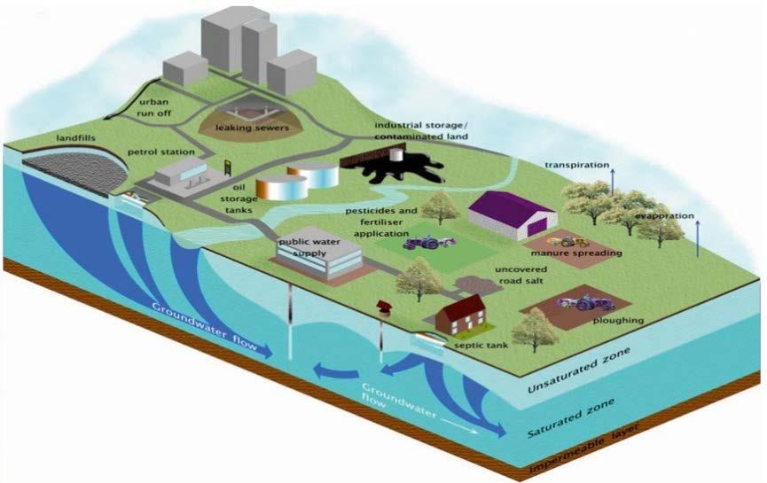

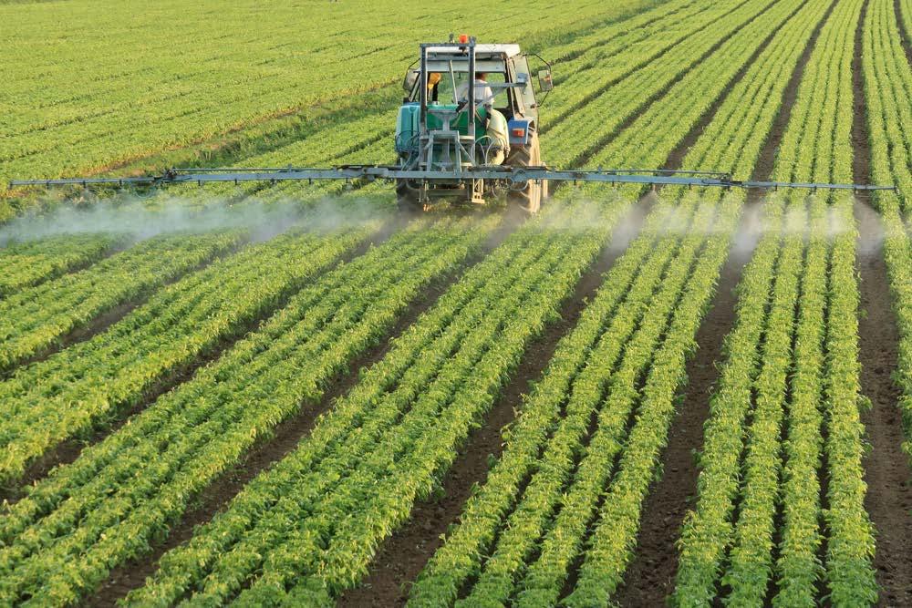
7 1) Drought mitigation 2) Water contaminant movement 3) Food production 4) Flood prevention Why do we care about the vadose zone?
8 Soils Basics

9 Slide By Trenton Franz Particles & Pores
10 Size of Soil Particles SAND: mm SILT: mm CLAY: < mm

11 Soil Texture Determined by the proportion of sand, silt and clay in a soil. Soil-texture Triangle Slide By Trenton Franz
12 Where is the soil profile likely located in Nebraska? A. Table Land B. Sandhills 15 ft Rz = Loamy Sand Vadose Zone Sand & Gravel T = 3-9 months C. River Valley D. None of the Above 50 ft Aquifer Sand and Gravel C = 7 yrs RZ = Root Zone T = Travel time to aquifer (years) C= Time from initial pollution to increase average concentration in aquifer by 10 ppm (years)
13 Where is the soil profile likely located in Nebraska? A. Table Land Rz = Fine Sand B. Sandhills C. River Valley 80 ft Vadose Zone Fine Sand T = 8 10 yrs D. None of the Above RZ = Root Zone T = Travel time to aquifer (years) C= Time from initial pollution to increase average concentration in aquifer by 10 ppm (years) 100 ft Aquifer Sand and Gravel C = 14 yrs
14 Where is the soil profile likely located in Nebraska? A. Table Land Rz = Silty Clay Loam B. Sandhills C. River Valley 80 ft Vadose Zone Silt Silt Loam T = yrs D. None of the Above RZ = Root Zone T = Travel time to aquifer (years) C= Time from initial pollution to increase average concentration in aquifer by 10 ppm (years) 100 ft Aquifer Sand and Gravel C = 14 yrs
15 a.gov/app/homepage.htm

16 a.gov/app/homepage.htm

17 a.gov/app/homepage.htm
18 a.gov/app/homepage.htm

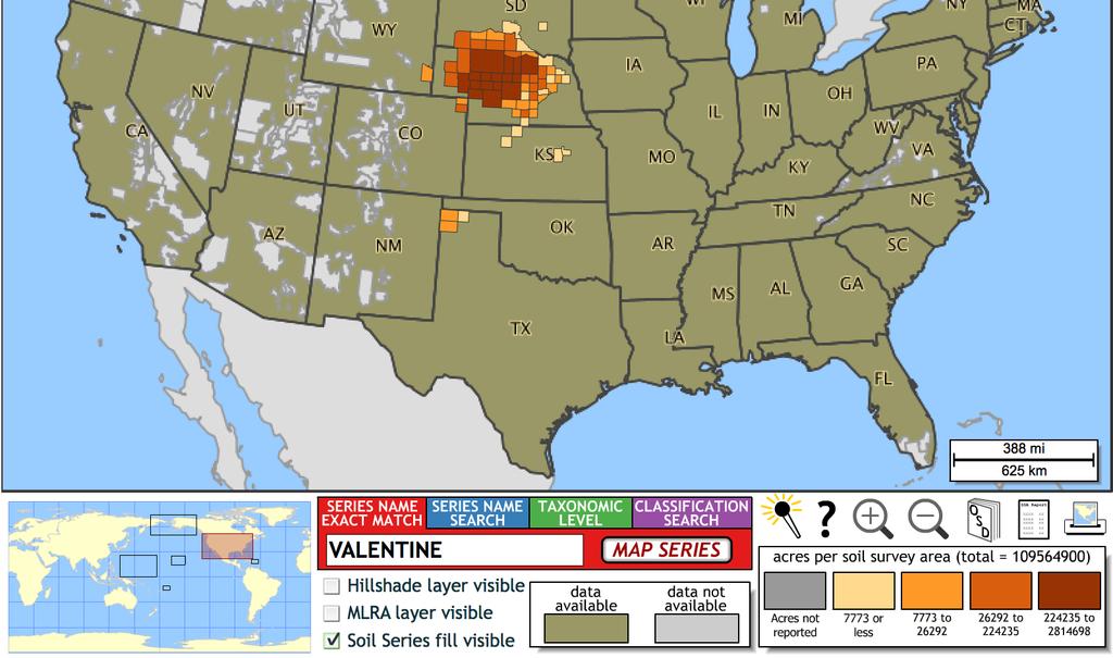
19 Common Nebraska Soils Potential for: Holdrege Nora Wymore Valentine Openland wildlife habitat Good Fair Fair Fair Nitrate leaching Moderate Low Moderate High Dryland crop yield potential Good Poor Good Poor Pesticide runoff Low High Moderate Low Sanitary facilities/septic system Recreational development campground Fair Fair Poor Good Good Moderate Fair Poor * Taken from UNL Plant and Soil Science Libraryhttp://passel.unl.edu/pages/informationmodule.php?idinformationmodu le= &topicorder=7&maxto=10
20 Water Movement
21 Water Movement Exfiltration Percolation Unsaturated Zone Infiltration Redistribution hydrat symbol Plant uptake Overland flow Interflow Saturated Zone Water table Recharge Groundwater Capillary rise Slide By Trenton Franz
22 Porosity vs Hydraulic Conductivity Porosity: Measure of the void (i.e. "empty") spaces in a material, and is a fraction of the volume of voids over the total volume, between 0 and 1, or as a percentage between 0 and 100%. Hydraulic Conductivity: Describes the ease with which water can move through pore spaces or fractures in the soil.
23 Which has the greater porosity? A B Beaker of Marbles Beaker of Beads A. Jar A B. Jar B C. Same in both jars Slide By Trenton Franz
24 Porosity vs Hydraulic Conductivity Porosity is the same in each beaker! Porosity 48% Porosity 48% Beaker of Marbles Beaker of Beads Slide By Trenton Franz
25 Which has the greater hydraulic conductivity (permeability)? A B Beaker of Marbles A. Jar A B. Jar B Slide By Trenton Franz Beaker of Beads C. Same in both jars
26 Porosity vs Hydraulic Conductivity Slide By Trenton Franz Which has the greatest hydraulic conductivity (permeability)? Beaker of marbles! WHY: The pore spaces are more connected and thus water flows more easily from the marble beaker. So for well sorted, spherical grains, with the same porosity, larger grain size means greater K values.
27 Porosity vs Hydraulic Conductivity HOWEVER: This relationship is not true for non-spherical, platy, or layered sediments such as clays, nor does it hold true for poorly sorted sediments. For example, clays have very high porosities, but very low hydraulic conductivities. Slide By Trenton Franz

28 Porosity vs Hydraulic Conductivity Slide By Trenton Franz
29 Pore Connectivity & Straightness of Path (Tortuosity) Soil Water or Groundwater Flow Well Sorted Gravel Clay Well Sorted Sand Sand & Gravel Slide By Trenton Franz

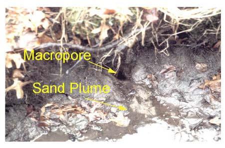
30 Slide By Trenton Franz Macropores

31 Slide By Trenton Franz

32 Slide By Trenton Franz
33 Infiltration Process by which water arriving at the soil surface enters the soil. At a given point, the rate of infiltration generally changes systematically with time during a given water-input event. Conditions affecting infiltration change between water-input events. Slide By Trenton Franz
34 Infiltration Event t=0 t=t w Water-Input rate, is the rate at which water arrives at the surface due to precipitation or irrigation. Depth of ponding, is the depth of water standing on the surface Infiltration rate, is the rate at which water enters the soil from the surface [L/T]. Infiltrability (infiltration capacity), is the maximum rate at which infiltration can occur [L/T]. This rate is NOT constant but changes during the infiltration event. Slide By Trenton Franz
35 Infiltration Conditions No Ponding: Infiltration rate = water-input rate and is infiltrability Infiltration is said to be supply-controlled. Slide By Trenton Franz
36 Infiltration Conditions Saturation From Above: Ponding is present because the waterinput rate exceeds the infiltrability Infiltration rate = infiltrability Rate of infiltration is determined by soil type and wetness and is said to be profile-controlled. Slide By Trenton Franz
37 Infiltration Conditions Saturation from below: Ponding is present because the water table has risen to or above the surface, and the entire soil column is saturated. Infiltration rate = zero Slide By Trenton Franz
38 How Do We Measure Infiltration? Infiltrometer a device for direct field measurement of infiltrability over a small area (0.02 to 1 m 2 ) Area defined by an impermeable boundary (typically a ring) Ponding due to saturation from above created by direct flooding at surface or by simulated rainfall Slide By Trenton Franz

39 Single-Ring Infiltrometer Constant Water Level Slide By Trenton Franz Drive a ring into the soil and supply water in the ring with a constant water level. The infiltration capacity of the soil is the maximum infiltration rate, and if infiltration rate exceeds the infiltration capacity, ponding and runoff will be the consequence. Therefore maintaining constant head means the rate of water supplied corresponds to the infiltration capacity or infiltrability. The supplying of water is done with a Mariotte bottle.

40 Single Ring Infiltrometer Falling Water Level Slide By Trenton Franz Drive a ring into the soil Fill with water to allow the water level inside the ring to drop with time. Records how much water goes into the soil for a given time period. The rate of which water goes into the soil is a measure of the soils ability to conduct water, called its permeability or hydraulic conductivity.
41 But There is a Problem! Water infiltrating into an unsaturated soil is influenced by BOTH gravitational and capillary (pressure) forces. So, the water moves BOTH vertically and horizontally. Thus, the measured infiltration rate exceeds the rate that would occur if the entire surface were ponded. Solution? - Use a double-ring infiltrometer. Slide By Trenton Franz

42 Double-Ring Infiltrometer Two concentric rings are ponded Area between inner and outer rings acts as a buffer zone Measurements on the inner ring only are used to compute infiltration rate Suggested ring diameters Inner 100 cm Outer 120 cm Slide By Trenton Franz
43 Factors Affecting Infiltration Rate Saturated Hydraulic Conductivity of the Soil Profile & Surface Organic Surface Layers Frost Swelling-Drying Rain Compaction Inwashing of Fine Sediment Human Modification of Soil Surface Water Content of Surface Pores Rising water table Low permeability layer at depth Soil Surface Characteristics Waxy organic coatings Other Hydrophobic compounds Surface Slope & Roughness Ponding increased until sufficient to overcome hydraulic resistance of the surface Overland Flow Depth of Ponding Physical & Chemical Properties of Water Surface tension Density Viscosity Temperature sensitive Slide By Trenton Franz
44 Nitrate-N Movement

45 Plant and Microbial Assimilation (Temporary Removal) Plant uptake NO 3- & NH 4 + Decomposition/ Mineralization

46 Groundwater Leaching
47 Denitrification (Permanent Removal) N 2 N 2 NO 3 - O 2 O 2 NO 3 - NO 3- & Organic Carbon NO 3 - NO 3 - O 2 NO 3 - O 2 NO 3 -
48
49 What is the vadose zone? A. Unsaturated zone B. Part of Earth between the land surface and groundwater C. Does not include the are that is still saturated above the water table (capillary fringe) D. All of the above
50 Why is the vadose layer A. Drought Mitigation B. Water Contamination Movement C. Food Production and Flood Prevention D. All of the above important?

51 A. Process by which water arriving at the soil surface enters the soil B. Measure of the void spaces in a material C. Ease water can move through pore spaces in the soil D. Rate at which water arrives at the surface due to precipitation or irrigation What is porosity?

52 What is the shortest flow path? A. B. C. D. Well Sorted Gravel Clay Well Sorted Sand Sand & Gravel

53 What impacts the vadose lag time? A. Viscosity B. Frost C. Rain Compaction D. All of the above
54 Thank you! Tiffany Messer Assistant Professor Biological Systems Engineering School of Natural Resources University of Nebraska-Lincoln
Page 1. Name:
 Name: 7574-1 - Page 1 1) The diagram below shows the result of leaving an empty, dry clay flowerpot in a full container of water for a period of time. The water level in the container dropped to level
Urban Soil Conservation and Management
 Urban Soil Conservation and Management Urban Soil include those located in: Cities in park areas Recreation areas Community gardens Green belts Lawns Septic absorption fields Sediment basins We need a
Water Budget IV: Soil Water Processes P = Q + ET + G + ΔS
 Water Budget IV: Soil Water Processes P = Q + ET + G + ΔS Infiltration Infiltration capacity: The maximum rate at which water can enter soil. Infiltration capacity curve: A graph showing the time-variation
Groundwater basics. Groundwater and surface water: a single resource. Pore Spaces. Simplified View
 Groundwater and surface water: a single resource Santa Cruz River, Tucson Groundwater basics Groundwater is water found within the pore spaces of geologic material beneath the surface of the Earth. It
BAEN 673 / February 18, 2016 Hydrologic Processes
 BAEN 673 / February 18, 2016 Hydrologic Processes Assignment: HW#7 Next class lecture in AEPM 104 Today s topics SWAT exercise #2 The SWAT model review paper Hydrologic processes The Hydrologic Processes
Lecture 11: Water Flow; Soils and the Hydrologic Cycle
 Lecture 11: Water Flow; Soils and the Hydrologic Cycle Water Flow in Soils Types of Water Flow in Soil Saturated flow: Soil pores completely filled with water; controlled by the hydrostatic potential After
East Maui Watershed Partnership Adapted from Utah State University and University of Wisconsin Ground Water Project Ages 7 th -Adult
 INTRODUCTION What is groundwater? Water contained in saturated soil and rock materials below the surface of the earth. It is not NEW water, but is recycled water through the hydraulic cycle. The source
Groundwater. Groundwater Movement. Groundwater Movement Recharge: the infiltration of water into any subsurface formation.
 On March 22, 2014, a major landslide occurred near Oso, Washington. Death toll currently at 30, with 15 still missing. Groundwater Before and After Swipe http://bit.ly/pen1jt N. Fork Stillaguamish River
Lecture 6: Soil Water
 6-1 GEOG415 Lecture 6: Soil Water Infiltration Movement of water into soil. Importance? - flood prediction -erosion -agriculture - water resources Infiltration capacity Expressed in the same unit as rainfall
CHAPTER 13 OUTLINE The Hydrologic Cycle and Groundwater. Hydrologic cycle. Hydrologic cycle cont.
 CHAPTER 13 OUTLINE The Hydrologic Cycle and Groundwater Does not contain complete lecture notes. To be used to help organize lecture notes and home/test studies. Hydrologic cycle The hydrologic cycle is
Groundwater 3/16/2010. GG22A: GEOSPHERE & HYDROSPHERE Hydrology
 GG22A: GEOSPHERE & HYDROSPHERE Hydrology Definitions Groundwater Subsurface water in soil or rock that is fully saturated. Aquifer Contains enough saturated material to yield significant quantities of
Lecture 20: Groundwater Introduction
 Lecture 20: Groundwater Introduction Key Questions for Groundwater 1. What is an aquifer? 2. What is an unconfined aquifer? 3. What is groundwater recharge? 4. What is porosity? What determines the magnitude
Hydrologic cycle, runoff process
 Hydrologic cycle, runoff process Motivation of hydrological modelling What happens at the catchment and in the stream when it rains? How does the increased/decreased runoff affect (not only) the landowners
Precipitation Surface Cover Topography Soil Properties
 Precipitation Surface Cover Topography Soil Properties Intrinsic capacity of rainfall to cause erosion Influenced by Amount, intensity, terminal velocity, drop size and drop size distribution of rain.
7. The diagram below represents cross sections of equal-size beakers A, B, and C filled with beads.
 Base your answers to questions 1 and 2 on the diagram below and on your knowledge of Earth science. The diagram represents four tubes, labeled A, B, C, and D, each containing 150 ml of sediments. Tubes
Timing Key Narrative Snapshots a) 00:44 How does groundwater recharge occur? How do streams form?
 00:44 How does groundwater recharge occur? How do streams form?") Module 4 Narration: Runoff and Recharge Timing Key Narrative Snapshots a) 00:44 How does groundwater recharge occur? How do streams form? These processes are closely linked. Lets first investigate how
Module 4 Narration: Runoff and Recharge Timing Key Narrative Snapshots a) 00:44 How does groundwater recharge occur? How do streams form? These processes are closely linked. Lets first investigate how
The Hydrological Cycle. Hydrological Cycle. Definition of Terms. Soils and Water, Spring Lecture 7, The Hydrological Cycle 1
 The Hydrological Cycle Water vapor helps warm up the earth Evaporation+Transpiration Chemical Spill Runoff To Oceans Water potential, atmosphere Hydrological Cycle Transpiration, T Atmospheric pool Interception
Ch. 5 - Nutrient Cycles and Soils
 Ch. 5 - Nutrient Cycles and Soils What are Nutrient (biogeochemical) Cycles? a process by which nutrients are recycled between living organisms and nonliving environment. The three general types of nutrient
EART 204. Water. Dr. Slawek Tulaczyk. Earth Sciences, UCSC
 EART 204 Water Dr. Slawek Tulaczyk Earth Sciences, UCSC 1 Water is an amazing liquid, (high heat capacity - particularly in phase transitions, maximum density at ca. 4 deg. C) 2 3 4 5 6 7 8 9 Basin Hydrologic
The nitrate contamination concern
 Section A The nitrate contamination concern In 1974, the U.S. Congress passed the Safe Drinking Water Act (SDWA). This law required the Environmental Protection Agency (EPA) to determine the level of contaminants
PART 2D. Section 7.2 of SJRWMD Special Publication SJ93-SP10
 PART 2D GEOTECHNICAL INVESTIGATION TO ESTIMATE AQUIFER PARAMETERS Note the word is estimate & not determine. Must appreciate the physical meaning of each aquifer parameter. Aquifer, in this sense, does
33. Fate of pesticides in soil and plant.
 33. Fate of pesticides in soil and plant. What Happens to Pesticides When a pesticide is released into the environment many things happen to it. Sometimes what happens is beneficial. For example, the leaching
Physiographic zones. and water quality
 Southland Physiographic zones Central Plains Technical information Physiographic zones are part of the Water and Land 2020 & Beyond project that aims to maintain and improve water quality in the Southland
Introduction to Groundwater. Photo: Joanne Offer/The IRC
 Introduction to Groundwater Photo: Joanne Offer/The IRC Groundwater Groundwater is water that has permeated or percolated into the ground. It is an important part of the water cycle. Groundwater is an
PART 1b. Section 7.2 of SJRWMD Special Publication SJ93-SP10
 PART 1b GEOTECHNICAL INVESTIGATION TO ESTIMATE AQUIFER PARAMETERS Note the word is estimate & not determine. Must appreciate the physical meaning of each aquifer parameter. Aquifer, in this sense, does
POROSITY, SPECIFIC YIELD & SPECIFIC RETENTION. Physical properties of
 POROSITY, SPECIFIC YIELD & SPECIFIC RETENTION Porosity is the the ratio of the voids to the total volume of an unconsolidated or consolidated material. Physical properties of n = porosity as a decimal
Introduction. Welcome to the Belgium Study Abroad Program. Courses:
 Introduction Welcome to the Belgium Study Abroad Program Courses: AGSM 335: Soil and Water Management BAEN 460: Principals of Environmental Hydrology BAEN 460 / AGSM 335 Combined lecture and HW sessions
SoilFacts Good Soil Management Helps Protect Groundwater
 Page 1 of 10 SoilFacts Good Soil Management Helps Protect Groundwater Table of Contents The Nature of Groundwater The Role of the Soil Soil Characteristics Depth Texture Organic Matter Content Groundwater
Overview. Students will...
 Overview Students will... Understand the interaction between ground water and surface water. Observe the difference between a permeable layer and an impermeable layer in an aquifer. See how water is stored
TECHNICAL NOTES U.S. DEPARTMENT OF AGRICULTURE NATURAL RESOURCES CONSERVATION SERVICE. TEXAS Revised May, 2011 NITROGEN LEACHING INDEX FOR TEXAS
 TECHNICAL NOTES U.S. DEPARTMENT OF AGRICULTURE NATURAL RESOURCES CONSERVATION SERVICE TEXAS Revised May, 2011 AGRONOMY TECHNICAL NOTE NUMBER 11 NITROGEN LEACHING INDEX FOR TEXAS INTRODUCTION The Nitrate
7-4 Soil. By Cyndee Crawford September 2014
 7-4 Soil By Cyndee Crawford September 2014 Soil Table of Contents 28.Chemical Weathering Lab 29.What is a Watershed? / Watershed Demo 30.Groundwater Layers Book 31.Groundwater Notes 32.What is an aquifer?
Groundwater. Chapter 10 11/22/2011. I. Importance of groundwater
 Groundwater Chapter 10 I. Importance of groundwater A. Groundwater is water found in the pores of soil and sediment, plus narrow fractures in bedrock B. Where is fresh water - 2 % of all water is fresh
EXAMPLE QUESTIONS NUTRIENT MANAGEMENT CERTIFICATION EXAM
 Department of Environmental Science and Technology EXAMPLE QUESTIONS NUTRIENT MANAGEMENT CERTIFICATION EXAM NOTE: The following questions were developed based on several of the knowledge areas for the
Land Application of Manure
 University of Nebraska Cooperative Extension EC 98-758-S WORKSHEET 11 Nebraska s Farm Assessment System for Assessing the Risk of Water Contamination Why should I be concerned? Stewardship of soil and
Design Guideline for Gravity Systems in Soil Type 1. January 2009
 Design Guideline for Gravity Systems in Soil Type 1 January 2009 This page is intentionally blank. Design Guideline for Gravity Systems in Soil Type 1 January 2009 For information or additional copies
Water Resources on PEI: an overview and brief discussion of challenges
 Water Resources on PEI: an overview and brief discussion of challenges Components: Components and links Atmospheric water Surface water (including glacial water) Groundwater Links: Precipitation (atm(
Who cares? You do! In India, one child dies every minute from severe acute malnutrition.
 Soil & Agriculture Who cares? You do! In India, one child dies every minute from severe acute malnutrition. Case Study: The Dust Bowl In the dirty thirties a large area of cropland was abandoned due to
Groundwater Hydrology
 Groundwater Hydrology Þröstur Þorsteinsson Environment and Natural Resources, University of Iceland Why study groundwater? Important source of fresh water Large portion of the Earth s fresh water as groundwater
Stormwater Retention Pond Recovery Analysis
 Stormwater Retention Pond Recovery Analysis By Nicolas E Andreyev The first in a series of courses on Green Drainage Design www.suncam.com Page 1 of 33 Forward To design a stormwater retention pond, one
Soil Properties that influence detachment and runoff
 Soil Properties that influence detachment and runoff Texture Structure Aggregation Density/compaction Wettability Antecedent soil moisture Organic Matter Sandy soils Sands are easily detacted However,
Hydrology for Drainage Design. Design Considerations Use appropriate design tools for the job at hand:
 Hydrology for Drainage Design Robert Pitt Department of Civil and Environmental Engineering University of Alabama Tuscaloosa, AL Objectives for Urban Drainage Systems are Varied Ensure personal safety
Definitions 3/16/2010. GG22A: GEOSPHERE & HYDROSPHERE Hydrology
 GG22A: GEOSPHERE & HYDROSPHERE Hydrology Definitions Streamflow volume of water in a river passing a defined point over a specific time period = VxA discharge m 3 s -1 Runoff excess precipitation - precipitation
New techniques for stabilizing, amending and revegetating mine waste
 New techniques for stabilizing, amending and revegetating mine waste Including soil regeneration, erosion resistance and revegetation treatments in mined land remediation designs Vic Claassen Soils and
Groundwater Earth 9th Edition Chapter 17 Mass wasting: summary in haiku form Importance of groundwater Importance of groundwater
 1 2 3 4 5 6 7 8 9 10 11 Groundwater Earth 9 th Edition Chapter 17 Geology 100 Mass wasting: summary in haiku form The grass is greener over the septic system said Erma Bombeck. Importance of groundwater
Why Care About Contaminants in Groundwater?
 Why Care About Contaminants in Groundwater? Subject/ target grade: Middle School (8 th grade) Earth Science Duration: Two 50 minute periods Setting: Classroom Materials and Equipment Needed: Per class
Freshwater. 260 Points Total
 9 SURFACE WATER SECTION 9.1 Surface Water Movement In your textbook, read about surface water and the way in which it moves sediment. Complete each statement. (13 points) 1. An excessive amount of water
Our Eastern Shore Groundwater Part IV Groundwater Quality on the Eastern Shore: How safe is our groundwater and are there ways we can protect it?
 Our Eastern Shore Groundwater Part IV Groundwater Quality on the Eastern Shore: How safe is our groundwater and are there ways we can protect it? Britt McMillan, Malcolm Pirnie, Inc. Mercury Venus Mars
Interpretation of Soil Moisture Content to Determine Soil Field Capacity and Avoid Over Irrigation in Sandy Soils Using Soil Moisture Measurements
 Interpretation of Soil Moisture Content to Determine Soil Field Capacity and Avoid Over Irrigation in Sandy Soils Using Soil Moisture Measurements By: Lincoln Zotarelli, Research Scientist, Michael D.
Challenges of Soil Nutrient Management
 Challenges of Soil Nutrient Management Agronomy Update Lethbridge, AB Jan 18, 2011 Ross H. McKenzie Agriculture Research Div. Alberta Agriculture Outline: 1. Effects of weather conditions on soils. 2.
global distribution of water!
 groundwater! hydrologic cycle! 2 global distribution of water! Source Volume Percent Ocean 97.2000 Glaciers and other ice 2.1500 Ground Water 0.6100 Lakes fresh 0.0090 saline 0.0080 Soil Moisture 0.0050
EES 1001 Lab 9 Groundwater
 EES 1001 Lab 9 Groundwater Water that seeps into the ground, and is pulled down by gravity through void spaces (*see below) in the soil and bedrock eventually percolates down to a saturated zone, a water-logged
Effect of Land Surface on Runoff Generation
 Effect of Land Surface on Runoff Generation Context: Hydrologic Cycle Runoff vs Infiltration Infiltration: Process by which water on the ground surface enters the soil Runoff: Water (from rain, snowmelt,
Lecture 21: Groundwater: Hydraulic Conductivity
 Lecture 21: Groundwater: Hydraulic Conductivity Key Questions 1. What causes groundwater to move? 2. What is the hydraulic conductivity? 3. What is Darcy s Law? 4. How is groundwater velocity estimated?
Summary of Water Monitoring Data
 Clay County Drainage Site Summary of Water Monitoring Data 2011 2015 Introduction The Red River Valley in northwestern Minnesota is experiencing an increase in the amount of agricultural subsurface drainage
Topsoil Loss and Modification During Suburbanization: Impact on Demands for Municipal Water. R.G. Darmody
 Topsoil Loss and Modification During Suburbanization: Impact on Demands for Municipal Water R.G. Darmody Department of Natural Resources and Environmental Sciences University of Illinois The Problem Demands
My Notes. Ka Hana Imi Na auao A Science Careers Curriculum Resource Go to: 1
 My Notes Ka Hana Imi Na auao A Science Careers Curriculum Resource Go to: www.cds.hawaii.edu/kahana 1 My Notes Ka Hana Imi Na auao A Science Careers Curriculum Resource Go to: www.cds.hawaii.edu/kahana
Laboratory Assignment #3
 UVIVERSITY OF IDAHO CE326/BAE356/FOR463 HYDROLOGIC MEASUREMENT TECHNIQUES Laboratory Assignment #3 Student Name: XXXXX Title: Infiltration Laboratory Date of Exercise: 3 October 200X Date of Submission:
SOIL AND THE HYDROLOGIC CYCLE
 GEOLOGY 408/508 SOIL AND THE HYDROLOGIC CYCLE CHAPTER 6 Brady & Weil, Rev. 14th ed. THE HYDROLOGIC CYCLE (FIGURE 6.2) WATER BALANCE EQUATION Watershed - an area of land drained by a single stream system
HYDRIC SOILS. By Neal Svendsen Resource Soil Scientist Natural Resources Conservation Service Sept 2006
 HYDRIC SOILS By Neal Svendsen Resource Soil Scientist Natural Resources Conservation Service Sept 2006 Wetlands and Hydric Soils The term hydric soils proposed by Cowardin in 1979 Classification of Wetlands
What is runoff? Runoff. Runoff is often defined as the portion of rainfall, that runs over and under the soil surface toward the stream
 What is runoff? Runoff Runoff is often defined as the portion of rainfall, that runs over and under the soil surface toward the stream 1 COMPONENTS OF Runoff or STREAM FLOW 2 Cont. The types of runoff
Salt-Clay Interactions: Reducing Sediment Loads and Erosion at Snow Storage Sites
 Salt-Clay Interactions: Reducing Sediment Loads and Erosion at Snow Storage Sites 17 th Street Snow Storage Site Wanda Goulden, P.Eng., P.Geol. General Supervisor, GeoEnvironmental Engineering Engineering
Of vital importance..
 Soil moisture Of vital importance.. Low and erratic rainfall form a significant cause of low crop production and crop failure in rainfed agriculture in the tropics However, crop and land management do
CHAPTER 4 DISCUSSION. Total Flow. For the study watershed, the water budget equation is defined as inflow equals
 CHAPTER 4 DISCUSSION Total Flow For the study watershed, the water budget equation is defined as inflow equals outflow minus any losses. Inflow consists of precipitation. Outflow consists of stream flow
Texture Definition: relative proportions of various sizes of individual soil particles USDA classifications Sand: mm Silt:
 Texture Definition: relative proportions of various sizes of individual soil particles USDA classifications Sand: 0.05 2.0 mm Silt: 0.002-0.05 mm Clay:
Transitioning from the Percolation Test to Soils Evaluation Colorado Environmental Health Association Annual Education Conference 2015
 Transitioning from the Percolation Test to Soils Evaluation Colorado Environmental Health Association Annual Education Conference 2015 Roy Laws, P.E. Jefferson County Public Health Warren S. Brown, P.E.
Compacted Urban Soils Effects on Infiltration and Bioretention Stormwater Control Designs
 Presented at the 9 th International Conference on Urban Drainage. IAHR, IWA, EWRI, and ASCE. Portland, Oregon, September 8-13, 2002. Compacted Urban Soils Effects on Infiltration and Bioretention Stormwater
Introduction. Wetland System. A Wetland Scene at Lorne C. Henderson Conservation Area near Petrolia
 Wetland Treatment of Wastewater This monograph, one in a series of single issue documents that deal with our local environment, has been prepared by the Sarnia-Lambton Environmental Association in co-operation
WATER AND THE HYDROLOGIC CYCLE
 WATER AND THE HYDROLOGIC CYCLE Summary Water is essential for the support of life and can be considered as a fundamental environmental good. Water is needed to support human habitation, grow crops and
Streamside Management. How the area around your pond effects the water.
 Streamside Management Zones and Water Quality How the area around your pond effects the water. Stream(pond)side Management Zone A streamside management zone (SMZ) is a strip of land immediately adjacent
Hydrology Review, New paradigms, and Challenges
 Hydrology Review, New paradigms, and Challenges Intent quick introduction with emphasis on aspects related to watershed hydrochemistry and new paradigms Watershed / Catchment Definition Portion of landscape
9. SOIL PERMEABILITY. 9.0 Why is it important to determine soil permeability?
 9. SOIL PERMEABILITY 9.0 Why is it important to determine soil permeability? Soil permeability is the property of the soil to transmit water and air and is one of the most important qualities to consider
FOCUS Groundwater - Introduction (Part I)
") - Introduction (Part I) Scenarios Workgroup (1,2) Recommend appropriate leaching models Define standard scenarios Develop comparable input parameterisation Define a method of processing the model output
- Introduction (Part I) Scenarios Workgroup (1,2) Recommend appropriate leaching models Define standard scenarios Develop comparable input parameterisation Define a method of processing the model output
Final Report FATE OF COALBED METHANE PRODUCED WATER IN DISPOSAL PONDS IN THE POWDER RIVER BASIN
 Final Report FATE OF COALBED METHANE PRODUCED WATER IN DISPOSAL PONDS IN THE POWDER RIVER BASIN 1. Abstract T.J. Kelleners, Associate Professor Soil Physics K.J. Reddy, Professor of Environmental Quality
Northwest Regional Certified Crop Adviser
 Northwest Regional Certified Crop Adviser Performance Objectives Prepared by Northwest Regional CCA Board CONTENTS Introduction... iii Soil Fertility Competency Areas...1 1 Basic concepts of soil fertility...2
Agronomic and soil quality trends after five years of different tillage and crop rotations across Iowa
 21 Integrated Crop Management Conference - Iowa State University 185 Agronomic and soil quality trends after five years of different tillage and crop rotations across Iowa Mahdi Al-Kaisi, associate professor
SOIL AND WATER MANAGEMENT
 SOIL AND WATER MANAGEMENT Competency Areas Competency Area 1: Basic Soil Properties... 2 Competency Area 2: Soil Hydrology... 6 Competency Area 3: Drainage and Irrigation... 20 Competency Area 4: Soil
Saturated Buffer. Subsurface Drainage PURPOSE N REDUCTION LOCATION COST BARRIERS
 Saturated Buffer To intercept tile drainage prior to discharging to surface waters and redistribute the water laterally in the soil profile of the streamside buffer. Subsurface drainage, also known as
Red River Valley Drainage Water Management Demonstration Project
 Red River Valley Drainage Water Management Demonstration Project Aaron Janz, Margaret Wagner, Jeppe Kjaersgaard Minnesota Department of Agriculture Drainage Research Forum November 23, 2015 Project Partners
1. Apply knowledge of the controlling variables for groundwater flow. 2. Demonstrate groundwater flow direction based on hydraulic head observations.
 .9-12 HYDRAULIC HEAD SUBJECTS: TIME: Science (Physical Science, Physics), Math 1 class period MATERIALS: Copies of student sheets and background information OBJECTIVES The student will do the following:
Irrigation Scheduling: Checkbook Method
 Know how. Know now. EC709 Irrigation Scheduling: Checkbook Method Steven R. Melvin, Extension Educator C. Dean Yonts, Extension Irrigation Specialist Irrigation scheduling helps determine when and how
PHYSICAL SOIL PROPERTIES
 PHYSICAL SOIL PROPERTIES Physical Soil Properties Santa Cruz County, California Scotts Valley Target Physical Soil Properties This table shows estimates of some physical characteristics and features that
Sizing Irrigation Fields
 GRAYWATER CURRICULUM Sizing Irrigation Fields Class 3 Objectives 1. Soil composition 2. Evapotranspiration 3. Determine Graywater Irrigation Fields Graywater production Determine water budget Calculating
Soil Degradation. Lesson Plan NRES B2-9
 Soil Degradation Lesson Plan NRES B2-9 Objectives 1. What is soil degradation? 2. How can construction result in soil degradation? 3. What are the sources of contamination, and how do they result in soil
GY 111 Lecture Note Series Groundwater and Hydrogeology
 GY 111 Lecture Notes D. Haywick (2008-09) 1 GY 111 Lecture Note Series Groundwater and Hydrogeology Lecture Goals A) The hydrologic cycle B) Groundwater dynamics C) Mapping groundwater (done in class not
Ponds. Pond A water impoundment made by excavating a pit, or constructing a dam or an embankment.
 POND SITE SELECTION AND CONSTRUCTION Uses, Planning, & Design David Krietemeyer Area Engineer USDA-NRCS June 20, 2008 Uses Considerations for Location of Commonly Used Terms Pond A water impoundment made
HOW CHANGES IN NUTRIENT MANAGEMENT REGULATIONS WILL AFFECT FORAGE PRODUCTION
 HOW CHANGES IN NUTRIENT MANAGEMENT REGULATIONS WILL AFFECT FORAGE PRODUCTION Dick Wolkowski and Larry Bundy Department of Soil Science University of Wisconsin What are the issues Forage producers typically
Module 2: Basic Stormwater Principles
 Module 2: Basic Stormwater Principles 2a. Overview... 2 Inspectors and stormwater management...2 Definition of stormwater runoff...3 VSMP technical criteria...3 Environmental Site Design...4 Best management
Standards for Soil Erosion and Sediment Control in New Jersey May 2012 STANDARD FOR GRASSED WATERWAYS. Definition. Purpose
 STANDARD FOR GRASSED WATERWAYS Definition A natural or constructed watercourse shaped or graded in earth materials and stabilized with suitable vegetation for the safe conveyance of runoff water. Purpose
Worksheet #8 Assessing the Risk of Groundwater Contamination from Livestock Yards Management
 Worksheet #8 Assessing the Risk of Groundwater Contamination from Livestock Yards Management Why should I be concerned? Livestock yards, such as barnyards, holding areas and feedlots, are areas of concentrated
SOIL COLUMN STUDY WITH POLYMER GEL
 SOIL COLUMN STUDY WITH POLYMER GEL FINAL REPORT Submitted to USDA WATER MANAGEMENT INTERNSHIP PROGRAM MAY 15, 2013 NAME: JAIDEEP CHOWDHURY UNVIERSITY NAME: CALIFORNIA STATE UNIVERSITY, FRESNO TIME PERIOD:
Nitrate, Well Testing and Rules
 Nitrate, Well Testing and Rules Where is all this heading? February 7, 2017 Pesticide and Fertilizer Management Division Minnesota Department of Agriculture Outline Nitrogen Fertilizer Management Plan
Stormwater BMP Maintenance
 Stormwater BMP Maintenance Background and Definitions What is Stormwater Runoff? Stormwater Stormwater is the result of precipitation that flows overland to streams and other bodies of water Stormwater
Estimating the Seasonal High Water Table: A Mix of Art & Science
 Estimating the Seasonal High Water Table: A Mix of Art & Science PONDS WORKSHOP - SJRWMD Devo Seereeram, Ph.D., P.E. This paper was originally written over 4 years ago & generated a lot of interest. The
URBAN FLOODING: HEC-HMS
 1.0 Introduction URBAN FLOODING: HEC-HMS -Sunil Kumar, Director, NWA All major ancient civilisations were developed in the river valleys because river served as source of water, food, transportation and
WATERSHED. Maitland Valley. Report Card 201
 Maitland Valley WATERSHED Report Card 201 The Maitland Valley Conservation Authority has prepared this report card as a summary on the state of our forests, wetlands, surface water, and ground water resources.
Soil Compaction. By: Kelly Patches Soils 401 April 8, 2009
 Soil Compaction By: Kelly Patches Soils 401 April 8, 2009 The Problem 3 acre field on my family s dairy farm has compaction Compaction forms a hardpan increase bulk density decrease pore space ponding/runoff
Chapter 2.3. Manure and Fertilizer as Sources of Nutrients and Potential Environmental Hazards. learning objectives
 Chapter 2.3 Manure and Fertilizer as Sources of Nutrients and Potential Environmental Hazards learning objectives Describe the advantages and disadvantages of fertilizer and manure as sources of nutrients
APPENDIX E. LESA Models
 APPENDIX E LESA Models LESA ASSESSMENT CALEXICO SOLAR FARM I PHASE A PROJECT AREA CALEXICO SOLAR FARM I PHASE A PROJECT (SW/4 Section 13, S/2 Section 14, S/2 NE/4 Section 15, NW/4 Section 15, T17S, R13E,
Septic Tank Soil Treatment Systems
 Bulletin 939 Septic Tank Soil Treatment Systems for Ohio Rural Homes Copyright 2009, The Ohio State University Ohio State University Extension embraces human diversity and is committed to ensuring that