Environmental Resource Inventories. What are ERIs? Significance of information How to use them
|
|
|
- Kory Matthews
- 5 years ago
- Views:
Transcription

1 Environmental Resource Inventories What are ERIs? Significance of information How to use them
2 Environmental Resource Inventory - ERI Compiled by the environmental commission Information about the natural resource characteristics and environmental features of your town. Objective & factual Text, maps, tables, bibliography
3 Why Do an ERI? Gives the Commission knowledge about natural resources protection and constraints Qualifies the Environmental Commission to receive development applications Provides information for town government, planners and developers Educates residents
4 ERI Is Critical for Master Planning (local land use ordinances) Natural Resource Protection Open Space & Recreation Planning Review of Development Applications Guiding Redevelopment Educating residents
5 Information to Include Introduction & Municipal Profile Climate Geology Geography/Topography Soils Hydrology Vegetation Critical Areas slopes, wetlands, floodplains, depth to bedrock, wildlife habitat Existing Land Use
6 Other Information Open Space: undeveloped private/public, recreation, agricultural, industrial Habitat Contaminated sites Existing infrastructure: sewers, roads, public transportation, public open space Historic, cultural, scenic, areas Air quality Noise sources
7 A Digression about Maps Base Maps - Town tax map (paper or digital) Aerial map from U.S. Geologic Survey All maps at same scale Resources - individually or combined, as long as map is not cluttered Geographic Information Systems (GIS)
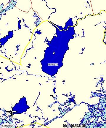
8 Map Layers - Water
9 Water and Floodplains

10 Water, Floodplains and Wetlands
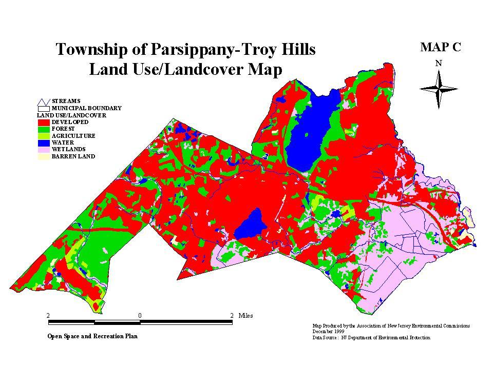
11 Land Use
12 DEP Map Info Available DEP Geographic Information System (GIS) Data accessible on DEP Website without GIS software for i-map NJ then, Launch i-map Find Location of Interest Municipality

13 Parsippany from i-map
14 Parsippany Wetlands
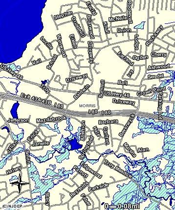
15 Zoomed in
16 Planning an ERI Decide what to include look at other ERIs Locate and contact information sources Decide who will do what Develop work plan Pursue funding sources Inform the public
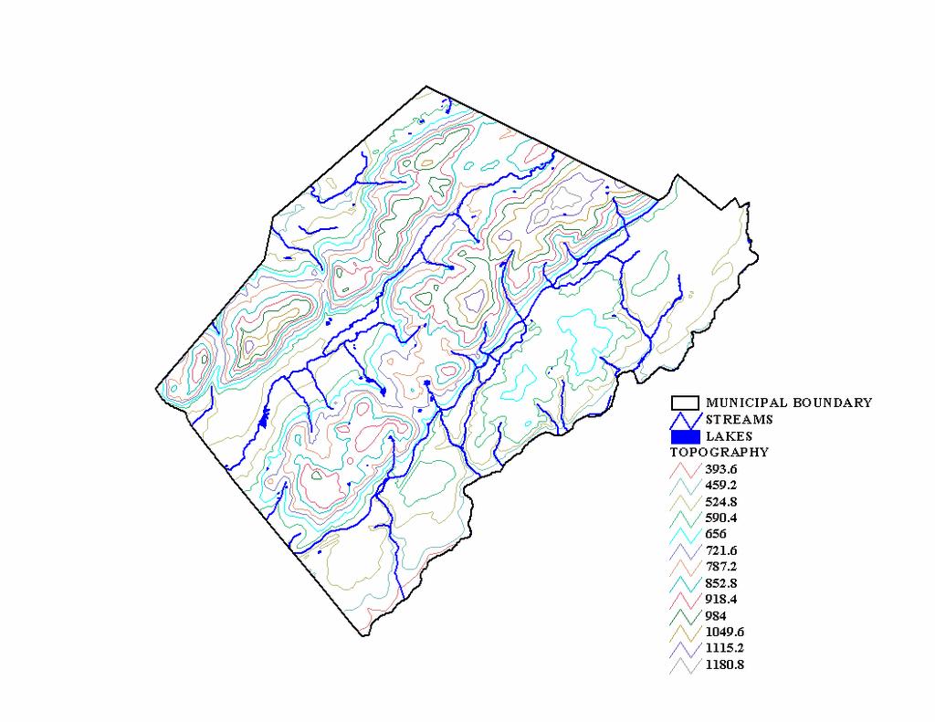
17 Geography Region, watershed, State Planning Area Physical features: slopes, drainage, vistas Topographical information
18 Topography Slope expressed in percent (%); 25-foot rise over 100 feet = 25% Steep slopes increase erosion, stormwater runoff, placement of roads, septic systems Slopes create the need for grading Slopes over 12% raise concerns

19 Limitations of Steep Slopes

20 Geology - NJ Geological Survey
21 Geology Groundwater availability Septics suitability Porous limestone Construction bearing strength Surficial deposits above bedrock - hold water, sources of sand and gravel

22 Soils Source: County Soil Survey Constraints Depth to bedrock: how shallow or deep; suitability for development, roads, etc. Wetlands: soil type, hydrology and vegetation Infiltration capacity affects the rate of surface water runoff, erosion and septics
23 Groundwater Hydrology Precipitation stored in rocks and sediments Map aquifer recharge areas (not necessarily adjacent to site), well head protection areas Water table: level in soil where all voids beneath are filled with water High water table limits land use, development and septics
24 Surface Water Hydrology Ponds, streams, rivers, lakes, reservoirs, wetlands, floodplains Quality of water Benefits of protecting surface water: scenic, recreational, drinking, wildlife
25
26 Vegetation Helps control soil erosion, floods, absorb air and water pollutants Clues to climate, soil, past and current land use Wildlife habitat Scenic and natural beauty Types Identify endangered/threatened species Locate historic trees

27 Forest Habitat DEP Landscape Data

28 Grassland Habitat
29 When to Update the ERI Physical changes in community - development, demolition Changes in natural systems - water table, wetlands boundaries
30 ERI Update- New Data Wetlands Mapping Wellhead areas Landscape Project data Contaminated sites Aquifer Surface Water Quality Standards Stream classifications


31 Summary ERI the database Master Plan the framework for local land use policy Ordinances have to agree with master plan
32 For additional Information publications
Site Plan and Subdivision Review
 Site Plan and Subdivision Review Municipal Land Use Framework Environmental Resource Inventory Master Plan Zoning Land Use Regulation Ordinance requirements for each zone Lot size, setbacks parking, cluster
VILLAGE OF BELLAIRE WATER QUALITY ACTION PLAN
 VILLAGE OF BELLAIRE WATER QUALITY ACTION PLAN Elk-River-Chain-of-Lakes Gaps Analysis Project The Watershed Center Grand Traverse Bay Tip of the Mitt Watershed Council Michigan Department of Natural Resources
Municipal Stormwater Management Plan Prepared For The Borough of Cape May Point By Van Note-Harvey Associates VNH File No.
 Municipal Stormwater Management Plan Prepared For The Borough of Cape May Point By Van Note-Harvey Associates 2005 VNH File No. 35317-210-21 Table of Contents Introduction... 3 Goals... 3 Storm water Discussion...
Environmental Information Worksheet
 Environmental Information Worksheet Water System Owner (Attach additional sheets if necessary) Needs and Alternatives Provide a brief narrative that describes: Current drinking water system needs. Project
ANCR INDIVIDUAL RESPONSES SUMMARY: 2/11/04 WATER RESOURCES GOALS AND OBJECTIVES
 ANCR INDIVIDUAL RESPONSES SUMMARY: 2/11/04 WATER RESOURCES GOALS AND OBJECTIVES Goal 1: Protect the health and safety of the Dane County population. a. Prevent development that may have an adverse effect
STREAM AND BUFFER AREA PROTECTION/RESTORATION
 STREAM AND BUFFER AREA PROTECTION/RESTORATION AMENDMENT OPTIONS TO STRENGTHEN POLICY IN HEADWATERS AREAS DRAFT SUBSEQUENT TO THE JANUARY 25, 2007 MEETING OF THE PLANNING COMMISSION ENVIRONMENT COMMITTEE
CLEARWATER TOWNSHIP WATER QUALITY ACTION PLAN
 CLEARWATER TOWNSHIP WATER QUALITY ACTION PLAN Elk-River-Chain-of-Lakes Gaps Analysis Project The Watershed Center Grand Traverse Bay Michigan Department of Environmental Quality July 2011 Purpose The Grand
groundwater. Because watersheds are complex systems, each tends to respond differently to natural or human activities.
 The private development of Altos del María is located at an altitude between 550 and 1,000 meters above sea level in the environmentally sensitive Cordillera Central of Panama that separates the Pacific
ELK RAPIDS TOWNSHIP WATER QUALITY ACTION PLAN
 ELK RAPIDS TOWNSHIP WATER QUALITY ACTION PLAN Elk-River-Chain-of-Lakes Gaps Analysis Project The Watershed Center Grand Traverse Bay Tip of the Mitt Watershed Council Michigan Department of Natural Resources
BANKS TOWNSHIP WATER QUALITY ACTION PLAN
 BANKS TOWNSHIP WATER QUALITY ACTION PLAN Elk-River-Chain-of-Lakes Gaps Analysis Project The Watershed Center Grand Traverse Bay Tip of the Mitt Watershed Council Michigan Department of Natural Resources
Characteristics of Land Resources
 Chapter Chapter 1 Characteristics of Land Resources The geology, soils and topography of Woodford County T he geology, soils and topography of an area are important to the community planning process for
Instructions for Notice of Ground Disturbance Form:
 Instructions for Notice of Ground Disturbance Form: Prior to beginning any ground disturbance activity or finalizing your storm water plan, submit a completed 2 page Notice of Ground Disturbance Form to
TORCH LAKE TOWNSHIP WATER QUALITY ACTION PLAN
 TORCH LAKE TOWNSHIP WATER QUALITY ACTION PLAN Elk-River-Chain-of-Lakes Gaps Analysis Project The Watershed Center Grand Traverse Bay Tip of the Mitt Watershed Council Michigan Department of Natural Resources
Appendix B Stormwater Site Plan Submittal Requirements Checklist
 Stormwater Site Plan Submittal Requirements Checklist The Submittal Requirements Checklist is intended to aid the design engineer in preparing a Stormwater Site Plan. All items included in the following
Maitland Valley WATERSHED
 Maitland Valley WATERSHED Report Card 2018 Maitland Conservation has prepared this report card as a summary of the state of your forests, wetlands, and water resources. WHERE ARE WE? We are one of 36 Conservation
Environmental Check List Georgia Environmental Policy Act
 Environmental Check List Georgia Environmental Policy Act Project No. : Project Name: GEORGIA IS AREA AFFECTED? IF AFFECTED, HOW SEVERELY? AREA/CATEGORY NO YES UNKNOWN MINOR MEDIAN MAJOR UNKNOWN 1. Wetlands
Municipal Stormwater Management Planning
 Municipal Stormwater Management Planning Christopher C. Obropta, Ph.D., P.E. Water Resources Extension Specialist with Rutgers Cooperative Extension Assistant Professor with Department of Environmental
Regional Master Plan Consistency Report 1/8/2010
 of 47 11:31 AM Regional Master Plan Consistency Report Prepared by State of New Jersey Highlands Water Protection and Planning Council 100 North Road (Route 513), Chester, NJ 07930 Telephone: (908) 879-6737
CHAPTER 4 - EROSION & SEDIMENT CONTROL AND STORMWATER MANAGEMENT ORDINANCE OF DUBUQUE COUNTY, IOWA. Adopted March 29, 2010.
 CHAPTER 4 - EROSION & SEDIMENT CONTROL AND STORMWATER MANAGEMENT ORDINANCE OF DUBUQUE COUNTY, IOWA Adopted March 29, 2010 Table of Contents Page Part 1 Introduction...3 4-1 Title..................3 4-2
SECTION 3 NATURAL RESOURCES
 SECTION 3 NATURAL RESOURCES The natural environment plays a large role in planning for future development. Environmental conditions, such as topography, wetlands, floodplains, and water bodies, can often
NEW JERSEY HIGHLANDS COUNCIL
 NEW JERSEY HIGHLANDS COUNCIL RELEASE OF PRELIMINARY TECHNICAL INFORMATION FOR THE REGIONAL MASTER PLAN June 2006 June 2006 Preliminary Information Release June 2006 Preliminary Information Release DRAFT
WQMP AMENDMENT REVIEW CHECKLIST
 State of New Jersey Highlands Water Protection and Planning Council 100 North Road (Route 513) Chester, New Jersey 07930-2322 (908) 879-6737 (908) 879-4205 (fax) www.highlands.state.nj.us WQMP AMENDMENT
MILTON TOWNSHIP WATER QUALITY ACTION PLAN
 MILTON TOWNSHIP WATER QUALITY ACTION PLAN Elk-River-Chain-of-Lakes Gaps Analysis Project The Watershed Center Grand Traverse Bay Tip of the Mitt Watershed Council Michigan Department of Natural Resources
WASA Quiz Review. Chapter 2
 WASA Quiz Review Chapter 2 Question#1 What is surface runoff? part of the water cycle that flows over land as surface water instead of being absorbed into groundwater or evaporating Question #2 What are
Pennichuck Brook Watershed Buildout Analysis December 2003
 INTRODUCTION The Pennichuck Brook watershed (Figure 1) includes approximately 17,700 acres within the communities of Amherst, Hollis, Merrimack, Milford and Nashua and is the primary drinking water supply
Eagle Harbor 2025: Planning for a Sustainable Community
 ENVIRONMENTAL FEATURES As a rural and riverfront community, Eagle Harbor has diverse environmental features. And as a coastal community the Town is vulnerable to certain hazards that have intensified with
Highlands Regional Master Plan
 Township of Montville Morris County, NJ Highlands Regional Master Plan prepared by Burgis Associates New Jersey Highlands Region 859,358 ac. Of that: Pl. Area Pres. Area 444,394 ac. 414,965 ac. Includes:
FLORIDA ATLANTIC UNIVERSITY
 Supporting Data The purpose of the Element is to ensure the conservation, protection, and wise use of all natural ecosystems and natural resources on the University campus and in the context area. 1. Inventory
CHAPTER 4 WATERSHED PLAN GOALS & OBJECTIVES
 4.0 Introduction CHAPTER 4 WATERSHED PLAN GOALS & OBJECTIVES After the watershed analysis had been completed, the next step in the planning process followed by the group was to come up with goals and objectives
Supplemental Guide II-Delineations
 Supplemental Guide II-Delineations Contents Source Water Protection Area Delineation... 1 Delineation Criteria for Systems Using Groundwater Sources... 2 Time of Travel... 4 Flow Boundaries... 4 Delineation
Traditional DEP Programs. Newer DEP Programs. Connecticut s Aquifer Protection Area Program. CT Aquifer Protection History
 Department of Environmental Protection Bureau of Water Protection and Land Reuse Traditional DEP Programs Working together to protect, maintain & restore Connecticut s water resources Newer DEP Programs
New York Rural Water Association. Local Source Water Protection and Smart Growth In Rural New York: A Guide For Local Officials
 New York Rural Water Association Local Source Water Protection and Smart Growth In Rural New York: A Guide For Local Officials Although the information in this document has been funded wholly or in part
ATTACHMENT 1 GEPA CHECKLIST & Historical Archeological & Natural Heritage Preservation Documents
 ATTACHMENT 1 GEPA CHECKLIST & Historical Archeological & Natural Heritage Preservation Documents INTRODUCTION The 1991 Session of the Georgia General Assembly passed Senate Bill 97, as amended, and it
Stormwater Erosion Control & Post-Construction Plans (Stormwater Quality Plans)
") Stormwater Erosion Control & Post-Construction Plans (Stormwater Quality Plans) Allen County Stormwater Plan Submittal Checklist The following items must be provided when applying for an Allen County Stormwater
Stormwater Erosion Control & Post-Construction Plans (Stormwater Quality Plans) Allen County Stormwater Plan Submittal Checklist The following items must be provided when applying for an Allen County Stormwater
3 Baseline and Existing Conditions
 1 2 3 4 5 6 7 8 9 10 11 12 13 14 3 Baseline and Existing Conditions The effective date of the VSP legislation is July 22, 2011. This is also the date chosen by the legislature as the applicable baseline
GUIDE TO THE DEVELOPMENT OF A MINING AND RECLAMATION PLAN IN NEW BRUNSWICK
 PROVINCE OF NEW BRUNSWICK DEPARTMENT OF ENERGY AND RESOURCE DEVELOPMENT Minerals and Petroleum Development Branch GUIDE TO THE DEVELOPMENT OF A MINING AND RECLAMATION PLAN IN NEW BRUNSWICK Guide to the
Sustainable Water Resource Practices
 Sustainable Water Resource Practices This section is related to and shoudl be read in conjunction with the Land Use Element, and Conservation Element. Implementing sustainable water resource practices
BAEN 673 / February 18, 2016 Hydrologic Processes
 BAEN 673 / February 18, 2016 Hydrologic Processes Assignment: HW#7 Next class lecture in AEPM 104 Today s topics SWAT exercise #2 The SWAT model review paper Hydrologic processes The Hydrologic Processes
IV. ENVIRONMENTAL/NATURAL RESOURCES
 IV. ENVIRONMENTAL/NATURAL RESOURCES The City of East Bethel is one of the largest cities in Minnesota encompassing approximately 48 square miles. The landscape of the community is a gentle undulating plain
What is a stormwater utility fee?
 What is a stormwater utility fee? A stormwater utility fee is similar to a water or sewer utility fee. In essence, customers pay a fee to convey stormwater from their properties. The City of Goodlettsville
The Environmental Resource Inventory: ERI
 RESOURCE P A P E R The Environmental Resource Inventory: ERI ASSOCIATION OF NEW JERSEY ENVIRONMENTAL COMMISSIONS P.O. Box 157 Mendham, NJ 07945 Tel:973-539-7547 Fax: 973-539-7713 E.mail: anjec@aol.com
Figure 1: Preservation Area
 Figure 1: Figure 2: Land Use Capability Map Zones Regional Master Plan Overlay Zone Designation Zone Protection Lakes Greater Than 10 acres Conservation Existing Community Sub-Zone Existing Community Environmentally
CHAPTER 7 PHYSICAL INVENTORY OF THE CITY
 CHAPTER 7 PHYSICAL INVENTORY OF THE CITY Chapter 7: Physical Inventory of the City 39 This page intentionally left blank. Chapter 7: Physical Inventory of the City 40 SECTION 1 PHYSICAL SETTING While communities
Reservoir age, increasing human population,
 B-6249 02/12 Eagle Mountain Watershed Management Brent Clayton, Justin Mechell, David Waidler and Clint Wolfe* Reservoir age, increasing human population, and changing land uses have prompted the development
Primer introduction to watershed management Plan Process highlight the major steps of plan development Project types look at some examples of common
 1 Primer introduction to watershed management Plan Process highlight the major steps of plan development Project types look at some examples of common projects Plan Organization how to read the plan Next
Surface Water. Solutions for a better world
 1 Surface Water Solutions for a better world Our Surface Water Services Expertise Growing worldwide awareness of water scarcity has encouraged water preservation programs, better irrigation techniques
Critical Areas Ordinance
 Public Review Draft //7 Public Review Draft //7 4 5 6 Kitsap County Code Title 9 Critical Areas Ordinance 7 8 9 0 Underline / Strike out Version 9.800 Appendices 4 5 6 7 8 9 0 4 5 Public Review Draft //7
CHAPTER 1 NATURAL RESOURCES, OPEN SPACE, AND FARMLAND
 CHAPTER 1 NATURAL RESOURCES, OPEN SPACE, AND FARMLAND The towns of Buckland and Shelburne lie west of Greenfield, in the foothills of the Berkshire Mountains. Both Buckland and Shelburne are fortunate
Nonpoint Source Pollution A Challenge to Control
 Nonpoint Source Pollution A Challenge to Control Connecticut Envirothon Aquatics Workshop January 14, 2017 Presented by Denise Savageau Conservation Director, Town of Greenwich Point Source Pollution is
PERMIT APPLICATION FEES Fees must be paid at time of application
 Permits SEPA Checklist Permit # Staff use Governmental agencies use this checklist to help determine whether the environmental impacts of your proposal are significant. This information is also helpful
STREET STANDARDS FOR PRIVATE ROAD/STREET. Number of Travel Lanes Width of Travel Lanes Width of Right-of-Way. Subbase - Bank Run Gravel (6" minus)
") L. Road Construction All roads shall be a minimum of 200' in length and shall comply with all applicable provisions of this ordinance. No building permit shall be issued for a property until the road constituting
L. Road Construction All roads shall be a minimum of 200' in length and shall comply with all applicable provisions of this ordinance. No building permit shall be issued for a property until the road constituting
BMP 5.4.2: Protect /Conserve/Enhance Riparian Areas
 BMP 5.4.2: Protect /Conserve/Enhance Riparian Areas The Executive Council of the Chesapeake Bay Program defines a Riparian Forest Buffer as "an area of trees, usually accompanied by shrubs and other vegetation,
WATERSHED. Maitland Valley. Report Card 201
 Maitland Valley WATERSHED Report Card 201 The Maitland Valley Conservation Authority has prepared this report card as a summary on the state of our forests, wetlands, surface water, and ground water resources.
North Country Stormwater Conference - Porous Pavement Section
 North Country Stormwater Conference - Porous Pavement Section Sponsored by Champlain Watershed Improvement Coalition of NY (CWICNY) October 14, 2010 Presentor Daniel R. Hershberg, P.E. & L.S. Managing
Support legislation that will protect the quantity of water in Lake Erie
 Specific Regional Priorities Each of Pennsylvania s major drainage basins has an array of individual characteristics that distinguish it from other regions of the state. These include diverse geographic
ENVIRONMENT LONG-TERM GOAL: INTRODUCTION: Environment 117
 ENVIRONMENT LONG-TERM GOAL: There is a complex relationship between physical geography and human life. Humans continually have a significant impact upon the environment through actions such as construction,
INDEPENDENCE TOWNSHIP
 MOUNT OLIVE TOWNSHIP MOUNT OLIVE TOWNSHIP Regional Master Plan Overlay Zone Designation Zone Protection Lakes Greater Than 10 acres Conservation Existing Community Sub-Zone Existing Community Environmentally
Chapter 3 Dispersion BMPs
 Chapter 3 Dispersion BMPs 3.1 BMP L611 Concentrated Flow Dispersion 3.1.1 Purpose and Definition Dispersion of concentrated flows from driveways or other pavement through a vegetated pervious area attenuates
LAND LIMITATION ENVIRONMENTAL LIMITATIONS
 LAND LIMITATION ENVIRONMENTAL LIMITATIONS Floodplains An ideal municipal solid waste landfill will have little or no floodplain areas within its boundaries. A site located within the 100-year floodplain,
TAC CHARRETTE WORKBOOK Ecosystem Management and Sustainable Forestry Practices
 For Discussion Purposes TAC CHARRETTE WORKBOOK Ecosystem Management and Sustainable Forestry Practices NEW JERSEY HIGHLANDS COUNCIL March 28, 2006 1 Overview of RMP Goals and Structure NEW JERSEY HIGHLANDS
ENVIRONMENTAL CHECKLIST (WAC )
") Fee: $400.00 Date Fee Paid: Received by: 186 Iron Horse Court, Suite 101, Yakima WA 98901 Phone: (509) 834-2050 Fax: (509) 834-2060 Website: http://www.yakimacleanair.org ENVIRONMENTAL CHECKLIST (WAC 197-11-960)
Fee: $400.00 Date Fee Paid: Received by: 186 Iron Horse Court, Suite 101, Yakima WA 98901 Phone: (509) 834-2050 Fax: (509) 834-2060 Website: http://www.yakimacleanair.org ENVIRONMENTAL CHECKLIST (WAC 197-11-960)
West Fork White River Watershed Conservation Map Summaries. Prepared for the Beaver Watershed Alliance. By the Watershed Conservation Resource Center
 West Fork White River Watershed Conservation Map Summaries Prepared for the Beaver Watershed Alliance By the Watershed Conservation Resource Center November 2014 The Watershed Conservation Resource Center
Black River Watershed Management Plan Plan
 Black River Watershed Management Plan Plan Final Report Part II: Appendices May 2010 This watershed management plan was prepared for the New York State Department of State Division of Coastal Resources
Contiguous Lots, Relationships & Special Topics Fall Darrin Hoverson Area Hydrologist
 Contiguous Lots, Relationships & Special Topics Fall 2018 Darrin Hoverson Area Hydrologist 1. Nonconforming Lots 2. SL Model Ordinance Update 3. New Review Process 4. Website Resources Regs & Administration
Model Riparian Buffer Ordinance.
 Model Riparian Buffer Ordinance. This is a sample riparian buffer ordinance written as an amendment to an existing zoning ordinance. This ordinance complies with the state minimum standards for river corridor
TECHNICAL CONTENT PROPOSED STEEP SLOPE REGULATION
 1 TECHNICAL CONTENT PROPOSED STEEP SLOPE REGULATION Draft 2/08/10 (Revised 02-14-11,Revised 02-21-11, Revised 03-03-11, Revised 04-19-11, Revised 04-20-11, Revised 05-05-11, Revised 05-09-11). DEFINITIONS
From My Backyard to Our Bay It s the 911 for the Chesapeake Bay
 From My Backyard to Our Bay Reporting Problems on Our Bay, Rivers, and Streams We can all be the eyes and ears of our local waterways. Maryland has established the Chesapeake Bay Safety and Environmental
Draft Highlands Regional Master Plan November 2007 Comment and Response Document
 Draft Highlands Regional Master Plan November 2007 Comment and Response Document Prepared by State of New Jersey Highlands Water Protection and Planning Council in Support of the Highlands Regional Master
Natural Resources of Chatham
 Natural Resources of Chatham Andrew Meyer, Beth Roessler, Karen Strong, and Emily Vail NYSDEC Hudson River Estuary Program and Cornell University Presentation to Town of Chatham, December 6, 2012 The Hudson
Vermillion River Headwaters Groundwater Recharge Area Inventory and Protection Plan
 Vermillion River Headwaters Groundwater Recharge Area Inventory and Protection Plan A project funded through a Metro Environmental Partnership grant from the Metropolitan Council with technical analysis
New Jersey Highlands Council RMP Update/Map Adjustment Review Municipal Petition for Plan Conformance SUMMARY OF FINDINGS RMP UPDATES/MAP ADJUSTMENTS
 New Jersey Highlands Council RMP Update/Map Adjustment Review Municipal Petition for Plan Conformance SUMMARY OF FINDINGS RMP UPDATES/MAP ADJUSTMENTS Please be advised that RMP Updates pertain to factual
DEKALB COUNTY STORMWATER MANAGEMENT PLAN PHASE 2
 DEKALB COUNTY STORMWATER MANAGEMENT PLAN PHASE 2 Introduction DeKalb County, Illinois, located approximately 50 miles west of Lake Michigan, is rectangular in shape, with a north/south dimension of 36
Conservation, Open Space & Groundwater Recharge Element
 Conservation, Open Space & Groundwater Recharge Element GOAL 1 ESTABLISH AND MAINTAIN AN INTEGRATED AND URBAN-DEFINING OPEN SPACE NETWORK THAT PROTECTS AND CONSERVES KEY ENVIRONMENTAL FEATURES. Objective
INFRASTRUCTURE ELEMENT/NATURAL GROUNDWATER AQUIFER RECHARGE SUB-ELEMENT
 I. INTRODUCTION A. Purpose As provided in this Natural Groundwater Aquifer Recharge Sub-element, the City of Ocoee has developed guidelines based on the St. Johns River Water Management District s programs.
Figure 1: Preservation Area
 Figure 1: Figure 2: Land Use Capability Map Zones Regional Master Plan Overlay Zone Designation Zone Protection Lakes Greater Than 10 acres Conservation Existing Community Sub-Zone Existing Community Environmentally
TOWN OF SMYRNA Water Quality Buffer Zone Policy
 TOWN OF SMYRNA Water Quality Buffer Zone Policy Section I - Description A water quality buffer zone (a.k.a. a riparian zone) is a strip of undisturbed native (indigenous) vegetation, either original or
IV. ENVIRONMENTAL IMPACT ANALYSIS G. HYDROLOGY/WATER QUALITY
 IV. ENVIRONMENTAL IMPACT ANALYSIS G. HYDROLOGY/WATER QUALITY ENVIRONMENTAL SETTING The project site is located in the Wilshire community of the City of Los Angeles and is bound by S. Wetherly Drive to
Project Priority List scoring worksheet - stormwater Guidance document
 www.pca.state.mn.us Project Priority List scoring worksheet - stormwater Guidance document PLEASE NOTE: THE MINNESOTA STATE FISCAL YEAR IS FROM JULY 1 JUNE 30 The first step towards receiving either a
CHELTENHAM TOWNSHIP Chapter 290: WATERSHED STORMWATER MANAGEMENT Article IV: Stormwater Management
 CHELTENHAM TOWNSHIP Chapter 290: WATERSHED STORMWATER MANAGEMENT Article IV: Stormwater Management Online ECode Available on Cheltenham Township Website at: http://ecode360.com/14477578 For all regulated
Issues, Concerns & Constraints
 Identifying Issues, Concerns & Constraints In order to identify the issues and concerns of watershed residents, several methods of gathering public input were employed. The Brodhead Watershed Association
5.0 LONG-TERM CEQA CONSIDERATIONS
 5.0 LONG-TERM CEQA CONSIDERATIONS Section 15126 of the CEQA Guidelines requires that all phases of a project must be considered when evaluating its impact on the environment, including planning, acquisition,
CHAPTER 10 CRITICAL DRAINAGE AREAS
 CHAPTER 10 CRITICAL DRAINAGE AREAS Contents 10.0 INTRODUCTION 10-1 10.1 IDENTIFICATION OF CRITICAL DRAINAGE AREAS 10-1 10.1.1 Site Physical Attributes 10-2 10.1.2 Protection of Fish & Wildlife Habitat
ENVIRONMENTAL QUALITY
 The natural environment of Douglas County presents a vast array of opportunities for, and constraints to development. A dynamic exists between development and the environment. The same natural beauty and
STAFF REPORT FOR POLICY PLAN AMENDMENT S10-CW-1CP
 STAFF REPORT FOR POLICY PLAN AMENDMENT S10-CW-1CP EXECUTIVE SUMMARY This Plan Amendment would serve to clarify policy guidance regarding circumstances under which proposals for disturbances to Environmental
CITY OF SNOHOMISH 116 UNION AVENUE SNOHOMISH, WASHINGTON (360)
") CITY OF SNOHOMISH 116 UNION AVENUE SNOHOMISH, WASHINGTON 98290 (360) 568 3115 WWW.SNOHOMISHWA.GOV STATE ENVIRONMENTAL POLICY ACT (SEPA) CHECKLIST PURPOSE OF CHECKLIST The State Environmental Policy Act
CITY OF SNOHOMISH 116 UNION AVENUE SNOHOMISH, WASHINGTON 98290 (360) 568 3115 WWW.SNOHOMISHWA.GOV STATE ENVIRONMENTAL POLICY ACT (SEPA) CHECKLIST PURPOSE OF CHECKLIST The State Environmental Policy Act
STORMWATER MANAGEMENT PLAN CONTENTS CHECKLIST Stormwater Management Plan Contents. SWMP Page # or Reference Location Yes/No
 STORMWATER MANAGEMENT PLAN CONTENTS CHECKLIST Stormwater Management Plan Contents Site Description A description of construction activity. The proposed sequence for major activities. Estimates of the total
(1)(A)Inventory of the following existing natural resources on the USFSP Campus or within the context area adjacent to the University.
(A)Inventory of the following existing natural resources on the USFSP Campus or within the context area adjacent to the University.") 13. 6C-21.208 CONSERVATION ELEMENT Information Sources George F. Young, Interview notes, June 2002 Sasaki Associates, Inc., interview notes, April, 2000 Interviews between DRMP Staff and USF Staff, May,
13. 6C-21.208 CONSERVATION ELEMENT Information Sources George F. Young, Interview notes, June 2002 Sasaki Associates, Inc., interview notes, April, 2000 Interviews between DRMP Staff and USF Staff, May,
August 3, The proposed action thus includes Site Plan approval for the Fire Department and Amended Site Plan approval for the Ambulance Corps.
 Scoping Document For Preparation of a Draft Environmental Impact Statement For the Putnam Valley Volunteer Fire Department Site Plan and Putnam Valley Volunteer Ambulance Corps Amended Site Plan Town of
Maine s Environmental Laws Protect Our Natural Resources
 Maine s Environmental Laws Protect Our Natural Resources Maine s Land Use Regulations Protection and Improvement of Waters Act Erosion and Sedimentation Control Law Stormwater Management Law Site Location
Long Island: Water Resources. Water Sayings. Water Issues. Water Quality Issues specific to LI Coastal Areas. Agriculture and Water Regulation
 Water Sayings Long Island: Water Resources Copyright 2011 AFG 1 All living things need water to survive after air. Water, water everywhere but not a drop to drink. The quality of water is just as important
Cannon River One Watershed, One Plan. POLICY COMMITTEE MEETING January 10, 2018 Rice County Government Center Faribault, MN
 Cannon River One, One Plan POLICY COMMITTEE MEETING January 10, 2018 Rice County Government Center Faribault, MN TASK Task 1. Aggregate Existing Physical & Spatial Data 1A. Create project maps 1B. Meeting
SECTION III LAND AND WATER RESOURCE INVENTORY
 III. LAND AND WATER RESOURCE INVENTORY In conformance with the Metropolitan Surface Water Management Act and as required in Minnesota Rules Section 8410.0060, this section of the plan provides a general
SCRCA SECTION 28 WETLAND POLICY
 April 21, 2016 SCRCA SECTION 28 WETLAND POLICY SCRCA Policies and Procedures of Administration of Section 28 Regulations Wetland Policies Definitions section (Source: Section 28 CA Act) Development means:
NATURAL FEATURES, LAND SUITABILITY FOR DEVELOPMENT AND DEVELOPMENT CONCERNS
 East Central Wayne County Comprehensive Plan - Natural Features, Land Suitability Page 170 NATURAL FEATURES, LAND SUITABILITY FOR DEVELOPMENT AND DEVELOPMENT CONCERNS Introduction The residents of East
Plan Review Background Paper Background Paper Number: 19 Planning & Development Department Date: September 2015
 Plan Review Background Paper Background Paper Number: 19 Planning & Development Department Date: September 2015 Environment Background East Hants is fortunate to enjoy the benefits of many natural resources
5. OTHER CEQA CONSIDERATIONS
 5. OTHER CEQA CONSIDERATIONS Cumulative Impacts CEQA requires the analysis of impacts due to cumulative development that would occur independent of, but during the same timeframe as, the project under
Maps for Nutrient Management Planning
 Maps for Nutrient Management Planning Table of Contents Introduction... 3 Dry Poultry NMP Exceptions... 3 Making a Base Map... 3 NRCS Toolkit... 3 Online Maps... 4 Photocopied Maps... 4 Additional or Supporting
Watershed: an area or ridge of land that separates waters flowing to different rivers, basins, or seas. It is the interdependent web of living
 Watershed: an area or ridge of land that separates waters flowing to different rivers, basins, or seas. It is the interdependent web of living organisms that inhabit a geographic area and depend on it
INFRASTRUCTURE ELEMENT Goal, Objectives and Policies
 INFRASTRUCTURE ELEMENT Goal, Objectives and Policies City of Bartow Comprehensive Plan Adopted August 5, 1991 Amended August 2, 1993, Amended 1996 & 1999 Adopted Changes January 16, 2001, Amended April