The Impact of Wetland Drainage on the Hydrology of a Northern Prairie Watershed
|
|
|
- Moses Wilfrid Jacobs
- 5 years ago
- Views:
Transcription

1 John Pomeroy, Xing Fang, Stacey Dumanski, Kevin Shook, Cherie Westbrook, Xulin Guo, Tom Brown, Adam Minke, Centre for Hydrology, University of Saskatchewan, Saskatoon, Canada The Impact of Wetland Drainage on the Hydrology of a Northern Prairie Watershed
2 Northern Prairie Hydrology Prairie runoff supplies smaller rivers, streams, sloughs and lakes Prairie Runoff forms in internally drained (closed) basins that are locally important but non-contributing to river systems that drain the prairies, OR drains directly to small prairie rivers (Battle, Souris, Assiniboine) >80% of runoff occurs during snowmelt period Blowing snow from fields to form snowdrifts in wetlands, woodlands and stream channels is critical to spring streamflow generation. Streamflow often ceases completely in summer when evapotranspiration consumes most available water. Baseflow (winter and dry season flow) from groundwater is often nonexistent.


3 Prairie Runoff Generation Snow Redistribution to Channels Spring melt and runoff Dry non-contributing areas to runoff Water Storage in Wetlands
4 Prairie Hydrological Connectivity The fill and spill hypothesis Lack of groundwater connections in this landscape heavy tills

5 Canadian Prairie Non-contributing Areas

6 Smith Creek, Saskatchewan
7 Smith Creek Hydrology Study Problem 1: Inability to reliably simulate streamflow in prairie basins where variable runoff contributing area, wetlands, and snowmelt play a major role in hydrology. Problem 2: Recent increase in streamflow volume and peak discharge in the area Objectives Examine changing climate, drainage and hydrology Develop and test a hydrological model suitable for wetland dominated Prairie basins. Use the model to estimate the sensitivity of recent high streamflows to wetland drainage

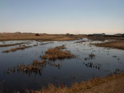
8 Smith Creek Research Basin 393 km 2 60 km southeast of Yorkton, Saskatchewan, Canada Agriculturally dominated and partially drained Wetland extent reduced from 24% to 10% and drainage channel length increased 8-fold from 1958 to


9 Smith Creek Pond Drainage No Drainage April 28, 2011 Artificial Drainage


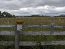
10 Instrumentation of Smith Creek Completed Summer 2007 Hydrometeorological Station 11 dual rain gauges 7 wetland level recorders


11 Main Weather Station Temperature, humidity, wind speed, shortwave radiation, longwave radiation, soil moisture, soil temperature, soil heat flux, snow depth, rainfall, snowfall

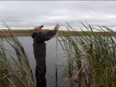
12 Snow and Soil Surveys


13 Smith Creek Basin Characteristics Drainage Network Spot Satellite Image

14 LiDAR-Derived Digital Elevation Model Drainage Network LiDAR topography Light Detection And Ranging

15 Derivation of Wetland Depressions


16 Historical Data Precipitation & Temperature Streamflow Environment Canada & Centre for Hydrology Precipitation data adjusted for spatial variability Water Survey of Canada
17 Changing Hydrology Smith Creek

18 Smith Creek near Marchwell, Water Survey of Canada Gauge, May 3, 2011 Note that the culvert that the rating curve is based upon is somewhere under the whirlpool.

19 PEAK FLOW! Smith Creek near Marchwell, Water Survey of Canada Gauge, May, 2011 Note that the culvert that the rating curve is based upon is somewhere under the whirlpool.
20 Temperatures Warming Annual max, min and mean temperatures increasing

21 Annual Precipitation No significant changes in annual precipitation
22 More Rainfall, Less Snowfall
23 Duration of Rainfall Increasing Frontal (multiple day) vs. Convective (single day) Increasing number of multiple day and total rain events MK p-value = MK p-value = May - Sept
24 Streamflow Volume Increasing Streamflow volume increased 12 fold 1994 to 2011 Large mixed rainfall & snowmelt contribution to 2011 flood Snowmelt Runoff 86% 70% 46% Mixed Runoff 7% 7% 21% Rainfall Runoff 7% 23% 33%
25 Runoff Ratio Increasing 15-fold increase in Runoff Ratio MK p-value = 0.001
26 Hydrological Modelling Prairie Hydrological Model (PHM) developed using the modular, object-oriented, physically-based Cold Regions Hydrological Modelling Platform (CRHM) PHM set up to describe hydrological processes operating in the basin. Snow redistribution, sublimation, accumulation and melt Pond storage, drainage Soil moisture storage, evapotranspiration and runoff Stream routing Satellite and LiDAR information used to describe Smith Creek as it was in 2008 Hourly weather data to run the model from 2007 to 2013
27 CRHM Prairie Hydrological Model Configuration PHM Flow Chart in Cold Regions Hydrological Model Platform (CRHM)

28 Wetland Representation in PHM
29 PHM Runs 2008 LiDAR DEM for stream drainage network and depressional storage capacity, 2007 satellite classification of land use Meteorological data from U of S weather station from : Air temperature Humidity Wind speed Solar radiation Precipitation (snowfall & rainfall)
30 Testing the PHM - Snowpack RMSD = 28 mm
31 Testing the PHM - Streamflow RMSD = 1.8 m 3 /s MB = -0.14
32 PHM Wetland Scenarios : Maximum known wetland extent and storage volume : Derived by linear interpolation of wetland areas between 1958 and 2000 along with area-volume relationships : Derived by linear interpolation of wetland areas between 1958 and 2000 along with area-volume relationships : Derived by linear interpolation of wetland areas between 1958 and 2000 along with area-volume relationships : 2000 DUC wetland extent was used to estimate wetland storage volumes : 2008 LiDAR DEM was used to determine the area, storage capacity and connectivity: considered current. 6. Loss Ceiling : All wetlands that occur outside of conservation lands in a sub-basin were drained. 7. Fully Drained : All wetlands were drained.
33 Smith Creek Wetland Drainage
34 Impact of Drainage on Annual Flow Volume
35 Impact of Wetland Area on Annual Flow Volume 2008 % change from 2008
36 Impact of Drainage on Peak Daily Discharge
37 Impact of Wetland Area on Peak Daily Discharge
38 Impact of Wetland Area on Proportional Change in Peak Daily Discharge
39 Observed Changes in Smith Creek Over one-half of wetlands have been drained over the last 56 years. Climate in the basin shows signs of global warming air temperatures have warmed substantially, especially in winter and spring increase in rainfall fraction of precipitation increased frequency of multi-day rainfall events Streamflow and runoff ratios have increased dramatically and disproportionately to climate Greater contribution from rain-on-snow and rainfall runoff processes Summer streamflow and flooding Gradual changes to the character of precipitation cannot fully explain the 12-fold increase in streamflow volumes and 15-fold increase in runoff ratios after The shifts after 1994 and 2010 are likely due to combinations of a changing climate, and recent increases in wetland drainage.
40 Wetland Drainage Model Outcomes Wetland drainage increases the size of both snowmelt (2011) and rainfall-runoff (2012) floods. In 2011 snowmelt flooding, limited surface water storage capacity did not reduce the impact of wetland drainage on streamflow volume or peak flows. In 2012 rainfall-runoff flooding, lack of surface water storage capacity did reduce the impact of wetland drainage on streamflow volume but did not reduce the impact on peak flows. Relative impact of wetland drainage is greatest for low to medium flow years but still important for high flow years
41 Conclusions In flood conditions; Wetland drainage has a very strong impact on streamflow. Modelled drainage of existing wetlands increases the 2011 peak flow by 78% and the 2011 flow volume by 32%. Wetland restoration has a strong impact on streamflow. Modelled restoration of current drainage to 1958 wetland conditions reduces the 2011 peak flow by 32% and the 2011 flow volume by 29%. In normal to dry years, wetland drainage has an exceptionally strong impact on streamflow. Modelled drainage of existing wetlands increases peak flows by 150% - 350%, and streamflow volumes by 200% - 300%. Over six years of simulation, complete wetland drainage increased total streamflow volumes by 55% and restoration to 1958 conditions decreased total volumes by 26%. The combination of climate change and wetland drainage has created hydrological regime change in Smith Creek with a dramatic increase in streamflow volume and runoff generation efficiency and the development of unprecedented rainfall induced and summer flooding in the last 20 years
42 Thanks Prairie Habitat Joint Venture Committee Saskatchewan Water Security Agency Manitoba Water Stewardship Agriculture and Agrifood Canada Environment Canada Ducks Unlimited Canada Smith Creek Watershed Association Canadian Foundation for Climate and Atmospheric Sciences Natural Science and Engineering Research Council of Canada Canada Research Chair Programme Contact John Pomeroy Centre for Hydrology Report No. 14
Prairie Hydrological Model Study Progress Report, April 2008
 Prairie Hydrological Model Study Progress Report, April 2008 Centre for Hydrology Report No. 3. J. Pomeroy, C. Westbrook, X. Fang, A. Minke, X. Guo, Centre for Hydrology University of Saskatchewan 117
Prairie Hydrology. If weather variability increases, this could degrade the viability of many aspects of ecosystems, human activities and economy
 Prairie Hydrology John Pomeroy, Xing Fang, Robert Armstrong, Tom Brown, Kevin Shook Centre for Hydrology, University of Saskatchewan, Saskatoon, Canada Climate Change for the Prairies? Highly variable
Characterising the Surface Hydrology of Prairie Droughts
 QdroD QdfoD Qdro Qdfo SunMax C:\ Program Files\ CRHM\ Qsi global CalcHr t rh ea u p ppt Qso Qn Qln SunAct form_data calcsun Qsi hru_t hru_rh hru_ea hru_u hru_p hru_rain hru_snow hru_sunact hru_tmax hru_tmin
Hydrology of Prairie Droughts
 C:\ Program Files\ CRHM\ QdroD QdfoD Qdro Qdfo SunMax global CalcHr Qsi calcsun hru_t hru_rh hru_ea hru_u hru_p hru_rain hru_snow hru_sunact hru_tmax hru_tmin hru_tmean hru_eamean hru_umean hru_rhmean
Prairie Hydrological Model Study Final Report
 Prairie Hydrological Model Study Final Report Centre for Hydrology Report No. 7 John Pomeroy, Xing Fang, Cherie Westbrook, Adam Minke, Xulin Guo, and Tom Brown Centre for Hydrology University of Saskatchewan
Canadian Prairie Hydrology and Runoff Generation. John Pomeroy Centre for Hydrology, University of Saskatchewan, Saskatoon
 Canadian Prairie Hydrology and Runoff Generation John Pomeroy Centre for Hydrology, University of Saskatchewan, Saskatoon www.usask.ca/hydrology Water Use in Saskatchewan Precipitation on average 350 mm
PLEASE SCROLL DOWN FOR ARTICLE. Full terms and conditions of use:
 This article was downloaded by: [Canadian Research Knowledge Network] On: 4 May 2011 Access details: Access Details: [subscription number 932223628] Publisher Taylor & Francis Informa Ltd Registered in
The Land & Infrastructure Resiliency Assessment (LIRA) Project Economic Flood Hazard Assessment
 Project Economic Flood Hazard Assessment") The Land & Infrastructure Resiliency Assessment (LIRA) Project Economic Flood Hazard Assessment Robert Armstrong / Cameron Kayter Agri-Environment Services Branch LIRA Background Subcomponent of Climate
The Land & Infrastructure Resiliency Assessment (LIRA) Project Economic Flood Hazard Assessment Robert Armstrong / Cameron Kayter Agri-Environment Services Branch LIRA Background Subcomponent of Climate
Drought, Climate Variability and Water Resources in Western Canada
 Drought, Climate Variability and Water Resources in Western Canada J.W. Pomeroy, K.R. Shook, R.N. Armstrong, X. Fang Centre for Hydrology University of Saskatchewan, Saskatoon, Canada www.usask.ca/hydrology
Water in the Columbia, Effects of Climate Change and Glacial Recession
 Water in the Columbia, Effects of Climate Change and Glacial Recession John Pomeroy, Centre for Hydrology University of Saskatchewan, Saskatoon @Coldwater Centre, Biogeoscience Institute, University of
Forests and Water in the Sierra Nevada. Roger Bales, Sierra Nevada Research Institute, UC Merced
 Forests and Water in the Sierra Nevada Roger Bales, Sierra Nevada Research Institute, UC Merced Some motivating points Water is the highest-value ecosystem service associated with Sierra Nevada conifer
Background to the Saskatchewan River Basin
 Background to the Saskatchewan River Basin Professor John Pomeroy Canada Research Chair in Water Resources & Climate Change, Centre for Hydrology, University of Saskatchewan, Saskatoon Canada www.usask.ca/hydrology
Prediction of snowmelt derived streamflow in a wetland dominated prairie basin
 doi:10.5194/hess-14-1-2010 Author(s) 2010. CC Attribution 3.0 License. Hydrology and Earth System Sciences Prediction of snowmelt derived streamflow in a wetland dominated prairie basin X. Fang, J. W.
Wetlands, Flood Control and Ecosystem Services in the Smith Creek Drainage Basin: A Case Study in Saskatchewan. John K. Pattison-Williams, PhD, PAg
 Wetlands, Flood Control and Ecosystem Services in the Smith Creek Drainage Basin: A Case Study in Saskatchewan John K. Pattison-Williams, PhD, PAg NAWMP 14 November 2018 Introduction and Problem Wetland
1 THE USGS MODULAR MODELING SYSTEM MODEL OF THE UPPER COSUMNES RIVER
 1 THE USGS MODULAR MODELING SYSTEM MODEL OF THE UPPER COSUMNES RIVER 1.1 Introduction The Hydrologic Model of the Upper Cosumnes River Basin (HMCRB) under the USGS Modular Modeling System (MMS) uses a
Effect of forest management on water yields & other ecosystem services in Sierra Nevada forests UCB/UC Merced/UCANR project
 Effect of forest management on water yields & other ecosystem services in Sierra Nevada forests UCB/UC Merced/UCANR project Some motivating points Water is the highest-value ecosystem service associated
Prairie Drought Hydrology Prediction using the Cold Regions Hydrological Model
 Q Q Q Q S Q si t r e a u p p p t Q so Q n Q ln S u n A c t fo rm d a ta d d d d u C : \ P r o g r a m F ile s \ C R H M \ E ro D fo D ro fo n M a x g lo b a l C a lc H r c a lc s u n Q si t r e a u p r
Marmot Creek, Peyto Glacier, Fortress Mountain Snow Laboratory in the Canadian Rockies Hydrological Observatory
 John Pomeroy, Warren Helgason, Cherie Westbrook Marmot Creek, Peyto Glacier, Fortress Mountain Snow Laboratory in the Canadian Rockies Hydrological Observatory Canadian Rockies Hydrological Observatory
Zhe Zhang 1, Yanping Li 1, Michael Barlage 2, Fei Chen 2. University of Saskatchewan 2. National Center for Atmospheric Research
 Zhe Zhang 1, Yanping Li 1, Michael Barlage 2, Fei Chen 2 1 University of Saskatchewan 2 National Center for Atmospheric Research Wetlands in Prairie Pothole Region Large area in the center of North America
Ensuring Sufficient Water Supply for the Emerging Bioeconomy
 Ensuring Sufficient Water Supply for the Emerging Bioeconomy John Pomeroy & Michael Solohub Canada Research Chair in Water Resources & Climate Change & Centre for Hydrology, University of Saskatchewan
Lecture 15: Flood Mitigation and Forecast Modeling
 Lecture 15: Flood Mitigation and Forecast Modeling Key Questions 1. What is a 100-year flood inundation map? 2. What is a levee and a setback levee? 3. How are land acquisition, insurance, emergency response
 Rocky Mountain Water Supply Resilience and Vulnerability Evaluation Project John Pomeroy, University of Saskatchewan Sean Carey, McMaster University John Diiwu, Alberta Agriculture and Forestry Masaki
Afternoon Lecture Outline
 Afternoon Lecture Outline 1. Northern Prairies watershed hydrology 2. Solute mass balance in lakes and ponds 3. Simple mass balance simulation using MS Excel 4. Effects of sediment-water exchange on lake
Natural Hazards: Flood
 Natural Hazards: Flood R. Halliday 1 Saskatchewan Flood and Natural Hazard Risk Assessment Stakeholder Workshop 1 R. Halliday & Associates June 2017 SRC Pub No. 13113-5D17 Flooding SK Hydrology 1 Saskatchewan
Prairie Hydrology, Flood Modelling and GIS
 Prairie Hydrology, Flood Modelling and GIS Saskatoon, March 20 21, 2012 Meeting Notes Summary of Prairie Hydrology, Flood Modelling and GIS Meeting This document provides a summary of the key outcomes,
Managing Forests for Snowpack Storage & Water Yield
 Managing Forests for Snowpack Storage & Water Yield Roger Bales Professor & Director Sierra Nevada Research Institute UC Merced NASA-MODIS satellite image NASA-MODIS satellite image Outline of talk Mountain
Climate Change in the Columbia Basin. Stephanie Smith Manager of Hydrology, BC Hydro
 Climate Change in the Columbia Basin Stephanie Smith Manager of Hydrology, BC Hydro June 20, 2017 Outline Climate change in the Columbia River basin What has happened? What could happen? What can we do
Afternoon Lecture Outline. Northern Prairie Hydrology
 Afternoon Lecture Outline 1. Northern Prairies watershed hydrology 2. Solute mass balance in lakes and ponds 3. Simple mass balance simulation using MS Excel 4. Effects of sediment-water exchange on lake
Afternoon Lecture Outline. Northern Prairie Hydrology
 Afternoon Lecture Outline 1. Northern Prairies watershed hydrology 2. Solute mass balance in lakes and ponds 3. Simple mass balance simulation using MS Excel 4. Effects of sediment-water exchange on lake
Using Information from Data Rich Sites to Improve Prediction at Data Limited Sites
 Using Information from Data Rich Sites to Improve Prediction at Data Limited Sites A Challenge for Hydrologic Prediction from Mountain Basins: DANNY MARKS Northwest Watershed Research Center USDA-Agricultural
Hydrologic Cycle. Water Availabilty. Surface Water. Groundwater
 Hydrologic Cycle Hydrologic ydoogccyce cycle Surface Water Groundwater Water Availabilty 1 Hydrologic Cycle Constant movement of water above, on, and, below the earth s surface (Heath) Endless circulation
CENTRAL ASSINIBOINE INTEGRATED WATERSHED MANAGEMENT PLAN SURFACE WATER HYDROLOGY REPORT
 CENTRAL ASSINIBOINE INTEGRATED WATERSHED MANAGEMENT PLAN SURFACE WATER HYDROLOGY REPORT Planning Area Boundary: The Central Assiniboine planning area covers the reach of the Assiniboine River from just
A Review of Canadian Prairie Hydrology: Principles, Modelling and Response to Land Use and Drainage Change
 A Review of Canadian Prairie Hydrology: Principles, Modelling and Response to Land Use and Drainage Change Centre for Hydrology Report #2 Version 2 - By - Xing Fang, Adam Minke, John Pomeroy, Tom Brown,
SNAMP water research. Topics covered
 SNAMP water research SNAMP water team UC Merced Topics covered Objectives, goals & overview What & why the water component of SNAMP Pre-treatment Observations Water Quality Water Quantity Modeling & Scenarios:
Hydrologic cycle, runoff process
 Hydrologic cycle, runoff process Motivation of hydrological modelling What happens at the catchment and in the stream when it rains? How does the increased/decreased runoff affect (not only) the landowners
DEPARTMENT OF GEOGRAPHY POST GRADUATE GOVT. COLLEGE FOR GIRLS.SECTOR-11 CHANDIGARH CLASS-B.A.II PAPER-A RESOURCES AND ENVIRONMENT: WORLD PATTERNS
 DEPARTMENT OF GEOGRAPHY POST GRADUATE GOVT. COLLEGE FOR GIRLS.SECTOR-11 CHANDIGARH CLASS-B.A.II PAPER-A RESOURCES AND ENVIRONMENT: WORLD PATTERNS Hydrological cycle The sun, which drives the water cycle,
Climate Change Water Implications for Michigan Communities, Landsystems and Agriculture
 Climate Change Water Implications for Michigan Communities, Landsystems and Agriculture Distinguished Senior Research Specialist Department of Geography Institute of Water Research Climate Change Summary
GCI Survey---Lake Winnipeg Watershed
 IISD-GWSP Conference. Winnipeg May 1-4, 2012 Water-Energy-Food Nexus GCI Survey---Lake Winnipeg Watershed A. A. WARKENTIN Hydrometeorologist GCI Survey Lake Winnipeg Watershed PRESENTATION OUTLINE WATERSHED
REPORT. Executive Summary
 C C C R 2 01 9 REPORT Executive Summary 2 Canada s Changing Climate Report Executive Summary 3 Authors Elizabeth Bush, Environment and Climate Change Canada Nathan Gillett, Environment and Climate Change
M.L. Kavvas, Z. Q. Chen, M. Anderson, L. Liang, N. Ohara Hydrologic Research Laboratory, Civil and Environmental Engineering, UC Davis
 Assessment of the Restoration Activities on Water Balance and Water Quality at Last Chance Creek Watershed Using Watershed Environmental Hydrology (WEHY) Model M.L. Kavvas, Z. Q. Chen, M. Anderson, L.
Storage dynamics simulations in prairie wetland hydrology models: evaluation and parameterization
 HYDROLOGICAL PROCESSES Hydrol. Process. (2013) Published online in Wiley Online Library (wileyonlinelibrary.com).9867 Storage dynamics simulations in prairie wetland hydrology models: evaluation and parameterization
ICELANDIC RIVER / WASHOW BAY CREEK INTEGRATED WATERSHED MANAGEMENT PLAN STATE OF THE WATERSHED REPORT CONTRIBUTION SURFACE WATER HYDROLOGY REPORT
 ICELANDIC RIVER / WASHOW BAY CREEK INTEGRATED WATERSHED MANAGEMENT PLAN STATE OF THE WATERSHED REPORT CONTRIBUTION SURFACE WATER HYDROLOGY REPORT Disclaimer: The hydrologic conditions presented in this
California s water cycle: climate, snowpack & forest management
 California s water cycle: climate, snowpack & forest management Roger Bales Professor & Director Sierra Nevada Research Institute UC Merced UC Merced NASA-MODIS satellite image SNRI mission Foster interdisciplinary
Non-point source modelling (HYPE and future of MESH/CHM)
") GWF Integrated Modelling Program for Canada (IMPC) kick-off workshop, September 14-15 th, 2017, NHRC, Saskatoon Non-point source modelling (HYPE and future of MESH/CHM) Diogo Costa, John Pomeroy, Howard
GWF Integrated Modelling Program for Canada (IMPC) kick-off workshop, September 14-15 th, 2017, NHRC, Saskatoon Non-point source modelling (HYPE and future of MESH/CHM) Diogo Costa, John Pomeroy, Howard
Hydrology Review, New paradigms, and Challenges
 Hydrology Review, New paradigms, and Challenges Intent quick introduction with emphasis on aspects related to watershed hydrochemistry and new paradigms Watershed / Catchment Definition Portion of landscape
FLOOD IMPACTS ON BUILT INFRASTRUCTURE AN OVERVIEW
 FLOOD IMPACTS ON BUILT INFRASTRUCTURE AN OVERVIEW PRAIRIES REGIONAL ADAPTATION COLLABORATIVE WEBINAR NOV. 22, 2018 THE ROLE OF INFRASTRUCTURE PLANNING IN FLOOD MITIGATION Darrell R. Corkal, P. Eng., President
The Changing Cold Regions Network: Atmospheric, Cryospheric, Ecological and Hydrological Change in the Saskatchewan and Mackenzie River Basins, Canada
 The Changing Cold Regions Network: Atmospheric, Cryospheric, Ecological and Hydrological Change in the Saskatchewan and Mackenzie River Basins, Canada John Pomeroy 1,2, Howard Wheater 2,1, William Quinton
Uncertainty in hydrologic impacts of climate change: A California case study
 Uncertainty in hydrologic impacts of climate change: A California case study Ed Maurer Civil Engineering Dept. Santa Clara University Photos from USGS Motivating Questions What are potential impacts of
Study of Hydrology based on Climate Changes Simulation Using SWAT Model At Jatiluhur Reservoir Catchment Area
 Study of Hydrology based on Climate Changes Simulation Using SWAT Model At Jatiluhur Reservoir Catchment Area Budi Darmawan Supatmanto 1, Sri Malahayati Yusuf 2, Florentinus Heru Widodo 1, Tri Handoko
MINING in a CHANGING CLIMATE Vulnerability, Impacts & Adaptation
 MINING in a CHANGING CLIMATE Vulnerability, Impacts & Adaptation Sudbury 2007 Mining and the Environment Tina Neale Adaptation & Impacts Research Division October 22, 2007 Presentation Outline How is the
FISHER RIVER INTEGRATED WATERSHED MANAGEMENT PLAN STATE OF THE WATERSHED REPORT CONTRIBUTION SURFACE WATER HYDROLOGY REPORT
 FISHER RIVER INTEGRATED WATERSHED MANAGEMENT PLAN STATE OF THE WATERSHED REPORT CONTRIBUTION SURFACE WATER HYDROLOGY REPORT Disclaimer: The hydrologic conditions presented in this report are estimates
M.L. Kavvas, Z. Q. Chen, M. Anderson, L. Liang, N. Ohara Hydrologic Research Laboratory, Civil and Environmental Engineering, UC Davis
 Assessment of the Restoration Activities on Water Balance and Water Quality at Last Chance Creek Watershed Using Watershed Environmental Hydrology (WEHY) Model M.L. Kavvas, Z. Q. Chen, M. Anderson, L.
Uncertainty in Hydrologic Modelling for PMF Estimation
 Uncertainty in Hydrologic Modelling for PMF Estimation Introduction Estimation of the Probable Maximum Flood (PMF) has become a core component of the hydrotechnical design of dam structures 1. There is
Coldwater Science Collaborative a support network for Water Users, Water Managers and Researchers John Pomeroy and Robert Sandford Centre for
 Coldwater Science Collaborative a support network for Water Users, Water Managers and Researchers John Pomeroy and Robert Sandford Centre for Hydrology University of Saskatchewan & Coldwater Science Collaborative,
Hydrology Attribute 1/15/2016. California Rapid Assessment Method for Wetlands. Hydrology. Precipitation Increases the Extent of Wetlands
 California Rapid Assessment Method for Wetlands Hydrology Attribute Hydrology Determines existence of wetlands, drives primary physical and ecological processes: Establishment of reducing conditions Nutrient
Regional Climate Change and Variability Projections. Dave Sauchyn, Prairie Adaptation Research Collaborative, U of R
 Regional Climate Change and Variability Projections Dave Sauchyn, Prairie Adaptation Research Collaborative, U of R Crown Managers Forum, Fernie, BC, April 14, 2010 Is the climate warming or cooling? Easterling
Hydrological sensitivity of a northern mountain basin to climate change
 HYDROLOGICAL PROCESSES Hydrol. Process. () Published online in Wiley Online Library (wileyonlinelibrary.com) DOI:./hyp. Hydrological sensitivity of a northern mountain basin to climate change Kabir Rasouli,
Memory effects of depressional storage in Northern Prairie hydrology
 HYDROLOGICAL PROCESSES Hydrol. Process. 25, 3890 3898 (2011) Published online 15 November 2011 in Wiley Online Library (wileyonlinelibrary.com) DOI: 10.1002/hyp.8381 Memory effects of depressional storage
Effects of shelterbelts on snow distribution and sublimation
 DOI 10.1007/s10457-011-9466-4 Effects of shelterbelts on snow distribution and sublimation John Kort Gary Bank John Pomeroy Xing Fang Received: 6 October 2011 / Accepted: 3 December 2011 Ó Springer Science+Business
Proposed Project. Integrated Water Resources Management Using Remote Sensing Data in Upper Indus Basin
 Proposed Project Integrated Water Resources Management Using Remote Sensing Data in Upper Indus Basin Background Snowmelt contributes more than 6% of water resources of Upper Indus Basin Most of the moisture
Modelling the Hydrologic Effects of. in the San Jose Watershed
 Modelling the Hydrologic Effects of Climate Change and Forest Management in the San Jose Watershed R.D. (Dan) Moore PhD PGeo Georg Jost PhD Departments of Geography and Forest Resources Management The
Estimating Groundwater Recharge under Upland and Depression Using a Simple Soil Water Balance Model
 Estimating Groundwater Recharge under Upland and Depression Using a Simple Soil Water Balance Model Ligang Xu, Masaki Hayashi, John Jackson and Laurence R. Bentley Department of Geosciences, University
Salt Dynamics in prairie wetlands under changing climate
 Salt Dynamics in prairie wetlands under changing climate Uri Nachshon Andrew Ireson Garth van der Kamp Howard Wheater Ryan Davies GIWS, University of Saskatchewan GIWS, University of Saskatchewan Environment
Climate change impacts on water resources in the Upper Po basin
 limate change impacts on water resources in the Upper Po basin Giovanni Ravazzani, Marco Mancini, hiara orbari, Alessandro eppi, Laura Boscarello, Giulia Ercolani Department of ivil and Environmental Engineering
Chad R. Ellis Chad Ellis & John Pomeroy Centre for Hydrology February 21, 2013
 Impacts of Forest Clearing on Radiation and Snowmelt in Marmot Creek, Alberta, Canada Chad R. Ellis Chad Ellis & John Pomeroy Centre for Hydrology February 21, 2013 Forest snowmelt Snowmelt timing controlled
The Water Survey of Canada Stream and Lake Gauging Network
 The Water Survey of Canada Stream and Lake Gauging Network Past and Future Hydroclimatic Variability: Applications to Water Resource Management in the Prairie Provinces The Water Survey of Canada Stream
Hydrology and Water Management. Dr. Mujahid Khan, UET Peshawar
 Hydrology and Water Management Dr. Mujahid Khan, UET Peshawar Course Outline Hydrologic Cycle and its Processes Water Balance Approach Estimation and Analysis of Precipitation Data Infiltration and Runoff
Calibrating the Soquel-Aptos PRMS Model to Streamflow Data Using PEST
 Calibrating the Soquel-Aptos PRMS Model to Streamflow Data Using PEST Cameron Tana Georgina King HydroMetrics Water Resources Inc. California Water Environmental and Modeling Forum 2015 Annual Meeting
Protecting and Enhancing Ecosystem Services the Role of Wetlands and Watershed Management in Flood Attenuation Dr. Mark Gloutney Director Regional
 Protecting and Enhancing Ecosystem Services the Role of Wetlands and Watershed Management in Flood Attenuation Dr. Mark Gloutney Director Regional Operations Eastern Canada April 14 2016 Changes in Storm
Perspectives on PUB the 4 th Biennium ( )
") Perspectives on PUB the 4 th Biennium (2009-2011) John Pomeroy PUB Chair Centre for Hydrology, University of Saskatchewan Saskatoon, Canada john.pomeroy@usask.ca PUB Approach PUB is a revolutionary movement
Perspectives on PUB the 4 th Biennium (2009-2011) John Pomeroy PUB Chair Centre for Hydrology, University of Saskatchewan Saskatoon, Canada john.pomeroy@usask.ca PUB Approach PUB is a revolutionary movement
Science supporting the Great Lakes Water Quality Agreement: Groundwater and Climate Change Information Needs and Gaps
 Science supporting the Great Lakes Water Quality Agreement: Groundwater and Climate Change Information Needs and Gaps Latornell Symposium November 19 2015 Great Lakes Water Quality Agreement Purpose: provide
BAEN 673 / February 18, 2016 Hydrologic Processes
 BAEN 673 / February 18, 2016 Hydrologic Processes Assignment: HW#7 Next class lecture in AEPM 104 Today s topics SWAT exercise #2 The SWAT model review paper Hydrologic processes The Hydrologic Processes
Pre-Event Activities. Blue River. Pre Field Trip Suggestions
 Blue River Have you heard we all live in a watershed? Well, it is true! This total body activity will allow students to demonstrate how water flows in a watershed while exploring how seasonal variations
Global Water Futures Programme and its Science Contributions to GEWEX
 Global Water Futures Programme and its Science Contributions to GEWEX John Pomeroy, Director, Global Water Futures Program Centre for Hydrology, University of Saskatchewan, Saskatoon & Canmore Our water
HYDROLOGY, WATER USE, AND INFRASTRUCTURE
 HYDROLOGY, WATER USE, AND INFRASTRUCTURE Water resources in the Blue Mountains are valued for fisheries and other aquatic biota, recreation, municipal and residential use, vegetation, agriculture, and
21st Century Climate Change In SW New Mexico: What s in Store for the Gila? David S. Gutzler University of New Mexico
 21st Century Climate Change In SW New Mexico: What s in Store for the Gila? David S. Gutzler University of New Mexico gutzler@unm.edu Silver City, NM June 5, 2008 Global Warming in the 20th/Early 21st
Introduction, HYDROGRAPHS
 HYDROGRAPHS Sequence of lecture Introduction Types of Hydrograph Components of Hydrograph Effective Rainfall Basin Lag or Time Lag Parts of Hydrograph Hydrograph Analysis Factors Affecting Hydrograph Shape
WASA Quiz Review. Chapter 2
 WASA Quiz Review Chapter 2 Question#1 What is surface runoff? part of the water cycle that flows over land as surface water instead of being absorbed into groundwater or evaporating Question #2 What are
Impacts of 2015 Drought on Streamflow in the Columbia River Basin
 Impacts of 2015 Drought on Streamflow in the Columbia River Basin Chris Konrad US Geological Survey Tacoma, WA May 11, 2016 1 Overview of USGS Investigation Western US had low snowpack, warm temperatures,
LOWER INTERLAKE BASIN - HYDROLOGY
 LOWER INTERLAKE BASIN - HYDROLOGY Disclaimer: The hydrologic conditions presented in this report are intended for watershed planning only and should not be used for licensing or design purposes. Utilization
Topography and the Spatial Distribution of Groundwater Recharge and Evapotranspiration:
 Topography and the Spatial Distribution of Groundwater Recharge and Evapotranspiration: A Need to Revisit Distributed Water Budget Analysis when Assessing Impacts to Ecological Systems. By M.A. Marchildon,
Long-term water level changes in closed-basin lakes of the Canadian prairies and the role of groundwater
 Long-term water level changes in closed-basin lakes of the Canadian prairies and the role of groundwater Garth van der Kamp, Environment Canada, Saskatoon Masaki Hayashi, Dwayne Keir, Alan Barr, Little
USDA-NRCS, Portland, Oregon
 Hydrologic Simulation Modeling for Streamflow Forecasting and Evaluation of Land and Water Management Practices in the Sprague River, Upper Klamath Basin, Oregon, USA David Garen John Risley Jolyne Lea
YUKON HYDROLOGIC RESPONSE WHAT WE KNOW AND WHAT WE THINK WE KNOW
 YUKON HYDROLOGIC RESPONSE WHAT WE KNOW AND WHAT WE THINK WE KNOW J Richard Janowicz Water Resources Branch Yukon Department of Environment Whitehorse, Yukon OVERVIEW Climate Change / Climate Warming Summarize
CONTINUOUS RAINFALL-RUN OFF SIMULATION USING SMA ALGORITHM
 CONTINUOUS RAINFALL-RUN OFF SIMULATION USING SMA ALGORITHM INTRODUCTION Dr. R N Sankhua Director, NWA, CWC, Pune In this continuous rainfall-runoff simulation, we will perform a continuous or long-term
GIS Framework to Evaluate Impact of Climate Change on Water Resources
 GIS Framework to Evaluate Impact of Climate Change on Water Resources Dr. Nagraj S. Patil A. K. Gosain, Professor Civil Engineering Department I. I. T. Delhi Objectives of the Study To Develop portal to
Country proposal - SRI LANKA
 Country proposal - SRI LANKA P. M. Jayatilaka Banda Department of Meteorology, Nihal Rupasinghe Central Engineering Consultancy Bureau and S. B. Weerakoon University of Peradeniya, Sri Lanka Asia Water
Coupling Transport and Transformation Model with Land Surface Scheme SABAE- HW: Application to the Canadian Prairies
 HW-1 Coupling Transport and Transformation Model with Land Surface Scheme SABAE- HW: Application to the Canadian Prairies Allan D. Woodbury, Alireza Hejazi Department of Civil Engineering University of
CHAPTER ONE : INTRODUCTION
 CHAPTER ONE : INTRODUCTION WHAT IS THE HYDROLOGY? The Hydrology means the science of water. It is the science that deals with the occurrence, circulation and distribution of water of the earth and earth
WATER AVAILABILITY AND DROUGHT CONDITIONS REPORT Manitoba. March 19, 2012
 Synopsis/Overview WATER AVAILABILITY AND DROUGHT CONDITIONS REPORT Manitoba March 19, Moderate drought conditions (meteorological) are prevailing in southern Manitoba and the southern parts of the Westman
Prof. D. Nagesh Kumar Drs A Anandhi, V V Srinivas & Prof Ravi S Nanjundiah
 Prof. D. Nagesh Kumar Department of Civil Engineering Indian Institute of Science Bangalore 560012 URL: http://www.civil.iisc.ernet.in/~nagesh Acknowledgement: Drs A Anandhi, V V Srinivas & Prof Ravi S
Inside of forest (for example) Research Flow
 Research Flow") Study on Relationship between Watershed Hydrology and Lake Water Environment by the Soil and Water Assessment Tool (SWAT) Shimane University Hiroaki SOMURA Watershed degradation + Global warming Background
Study on Relationship between Watershed Hydrology and Lake Water Environment by the Soil and Water Assessment Tool (SWAT) Shimane University Hiroaki SOMURA Watershed degradation + Global warming Background
Stream hydrographs. Stream hydrographs. Baseflow. Graphs of river stage or discharge at a single location as a function of time
 Stream hydrographs Graphs of river stage or discharge at a single location as a function of time Hydrologic og budget Discharge: units? How is it measured? Show fluctuating water levels in response to
SOUTHEAST TEXAS CONTINUING EDUCATION
 EXAM No. 118 FLOOD - RUNOFF ANALYSIS 1. Information gained from flood - runoff analysis includes which one: A. Stage, discharge, volume. B. Measure depth, volume. C. Velocity, depth, storm occurrence.
Definitions 3/16/2010. GG22A: GEOSPHERE & HYDROSPHERE Hydrology
 GG22A: GEOSPHERE & HYDROSPHERE Hydrology Definitions Streamflow volume of water in a river passing a defined point over a specific time period = VxA discharge m 3 s -1 Runoff excess precipitation - precipitation
How could we possibly change the Hydrologic Cycle on an Island as big as Vancouver Island?
 How could we possibly change the Hydrologic Cycle on an Island as big as Vancouver Island? Do you think for a moment that humans altering the Hydrologic Cycle would also change the Weather? Precipitation
Drought impacts on Canadian prairie wetland snow hydrology
 HYDROLOGICAL PROCESSES Hydrol. Process. (2008) Published online in Wiley InterScience (www.interscience.wiley.com).7074 Drought impacts on Canadian prairie wetland snow hydrology X. Fang* and J. W. Pomeroy
Wireless-Sensor Technology for Basin-Scale Hydrology
 Wireless-Sensor Technology for Basin-Scale Hydrology Roger C Bales, Ph.D. Professor, School of Engineering Director, Sierra Nevada Research Institute University of California, Merced 5200 N Lake Road Merced,
Water & Sierra Nevada forests
 Water & Sierra Nevada forests What we know 1. Vegetation removal generally results in more runoff, initially 2. Vegetation regrowth means less runoff 3. Clear cutting or wildfire means more sublimation
Application of the SWAT Model to the Hii River Basin, Shimane Prefecture, Japan
 Application of the SWAT Model to the Hii River Basin, Shimane Prefecture, Japan H. Somura, I. Takeda, Y. Mori Shimane University D. Hoffman Blackland Research and Extension Center J. Arnold Grassland Soil