Environmental Impact Assessment Guidelines. Regional Official Plan Guidelines
|
|
|
- Homer Joseph
- 5 years ago
- Views:
Transcription

1 Environmental Impact Assessment Guidelines Regional Official Plan Guidelines
2
3 Halton Region Official Plan Guidelines The Regional Official Plan (ROP) is Halton s guiding document for land use planning. It contains policies that guide decisions related to, among other things, managing growth and its effects on Halton s social, economic and natural environment. The ROP Guidelines are a set of documents that clarify, inform, and aid in the implementation of the Plan s policies. This Plan calls for the preparation of certain guidelines or protocols to provide more detailed directions in the implementation of its policies. Halton Region Official Plan [2009] Section 192 The Guidelines have been prepared in accordance with Section 192 of the ROP. They provide direction and outline approaches that can be used to satisfy the relevant policies of the Plan. They do not introduce additional policy requirements, and, in the event of a conflict between the Guidelines and the Regional Official Plan, the Plan shall prevail. The Guidelines may be updated from time to time as required through a report to Regional Council. For more information, visit halton.ca/rop or halton.ca/ropguidelines or call 311.
4
5 Environmental Impact Assessment Guidelines The Environmental Impact Assessment (EIA) Guidelines is intended to provide guidance regarding the Region s policies on the Regional Natural Heritage System and Environmental Impact Assessments. Purpose The purpose of the Environmental Impact Assessment (EIA) Guidelines is to: explain the Regional Official Plan policies regarding the Regional Natural Heritage System and requirements for triggering an EIA; provide methodologies and identify the level of detail required for an EIA; identify ways to avoid or minimize potential impacts to the Regional Natural Heritage System and its key features and ecological functions; and, enable municipal decision-making on development proposals which have the potential to impact the Regional Natural Heritage System. Application & Use To maintain a healthy balance between settlement areas, the rural countryside and the Regional Natural Heritage System (RHNS), when development is proposed within or adjacent to the RHNS, an Environmental Impact Assessment (EIA) may be required. The Guidelines should be used to understand the implementation of these requirements and are applicable to a variety of users, including: Regional, Local and external agency staff: as a resource when reviewing development applications that may require an EIA; the development industry and agricultural community: for clarity on the application of Regional Official Plan policy regarding EIAs; and the public: to understand how the protection and promotion of the Regional Natural Heritage System occurs through the development process. Supporting Documents In addition to the policy direction provided by the Regional Official Plan, the following documents should be considered alongside this Guideline, as appropriate: Provincial Policy Statement, 2014 Ministry of Natural Resources Natural Heritage Reference Manual Local Official Plan & Zoning By-law Version Version 1.0 This version of the Environmental Impact Assessment Guidelines was brought before the Inter-Municipal Liaison Committee on June, through Report No. IMLC01-14 Note: This version of the EIA Guidelines is based on the Regional Official Plan as amended by Regional Official Plan Amendment (ROPA) 38, adopted by Regional Council on December16, Many of the ROP policies related to Environmental Impact Assessments are currently under appeal at the Ontario Municipal Board. The EIA Guidelines may be updated if required at the end of the hearing process.
6
7 Table of Contents 1.0 Introduction Purpose When an EIA Is Required Planning Approval Authority and Agency Roles Role of the Proponent Agricultural Buildings Recommended Procedures Pre-consultation Screening Scoping Submission and Approval of Terms of Reference Delineation and Refinement of the RNHS Boundary Draft EIA Final EIA Contents of an EIA Introduction Approach Biophysical Inventory Biophysical Analysis Development Proposal Description Impact Assessment Mitigation Strategies Monitoring Plan Conclusions Appendix A: EIA Trigger Figures Appendix B: Contact Information for Planning Approval Authorities and Agencies Appendix C: Screening and Scoping Checklist for Agricultural Buildings Appendix D: EIA Procedure Flow Chart Appendix E: EIA Methods and References Appendix F: Maps from ROPA Appendix G: Potential Environmental Impacts Appendix H: Potential Mitigation Measures Appendix I: Definitions... 39
8 1
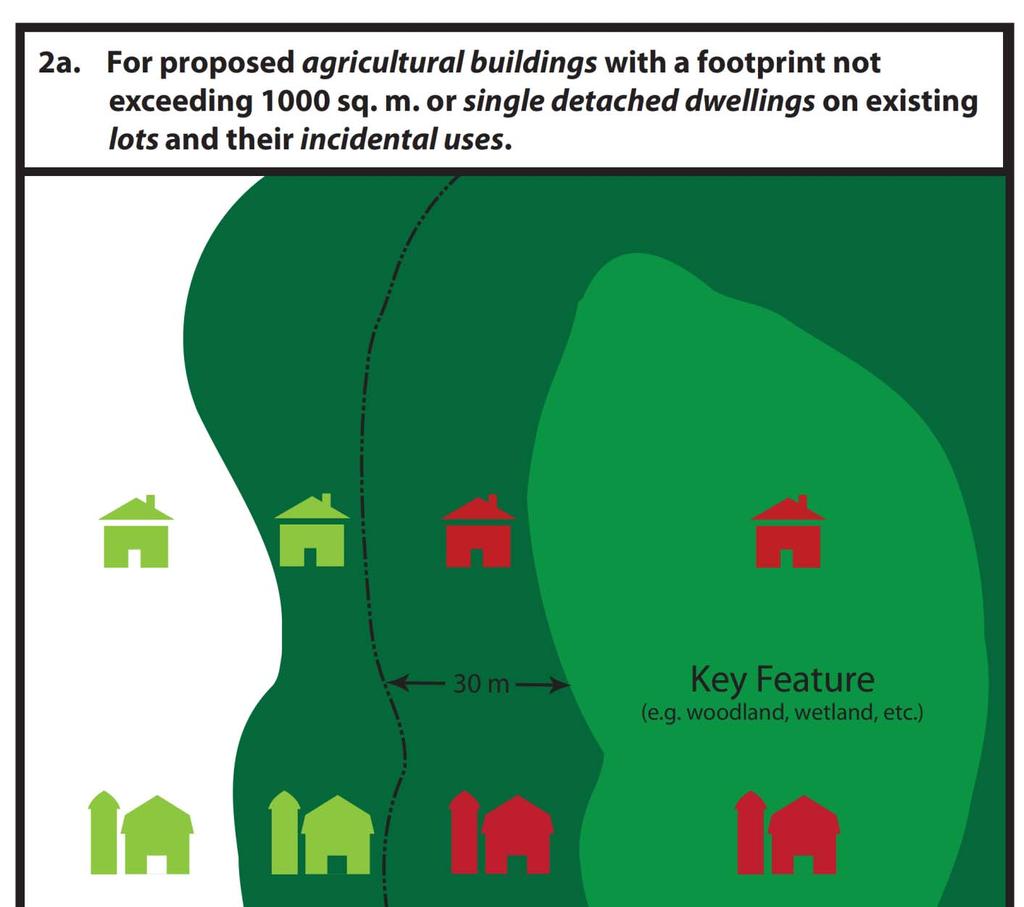
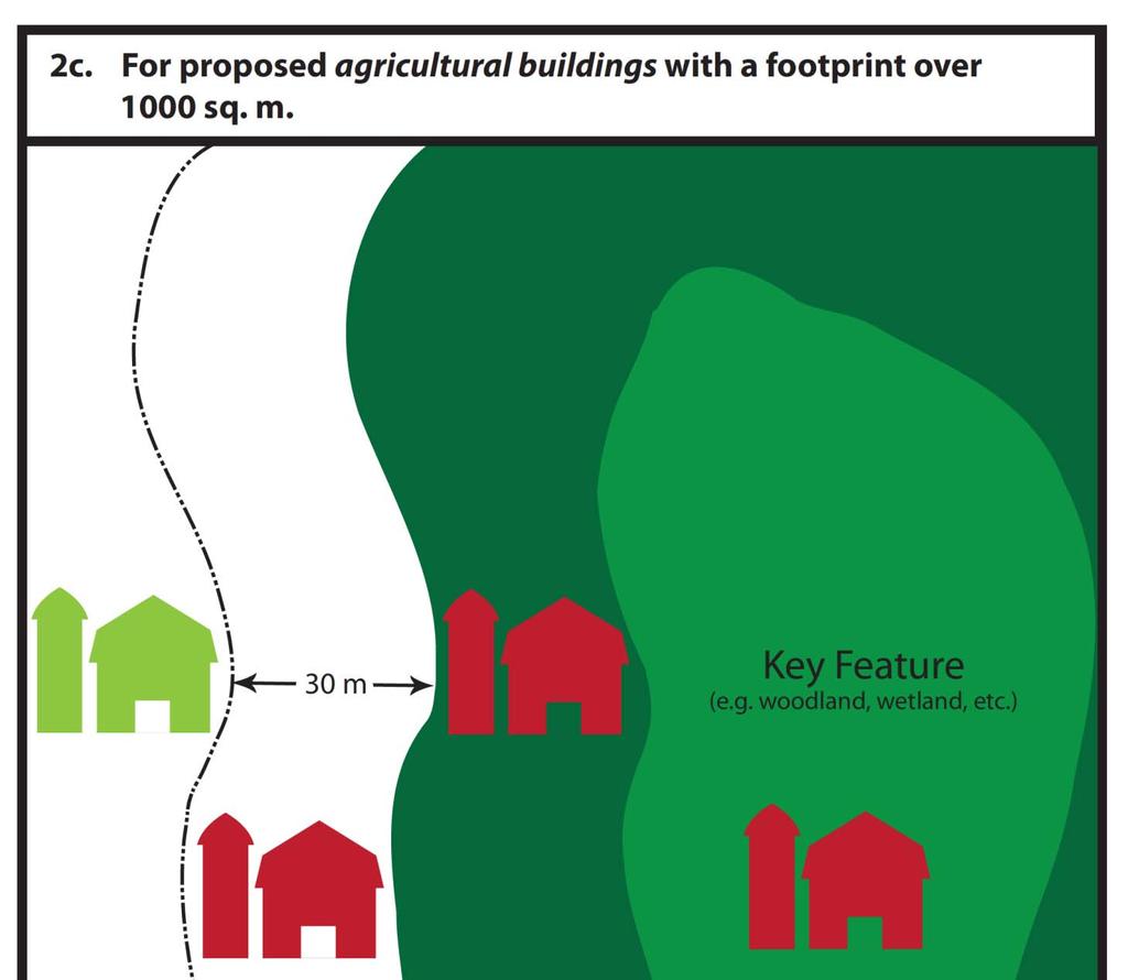
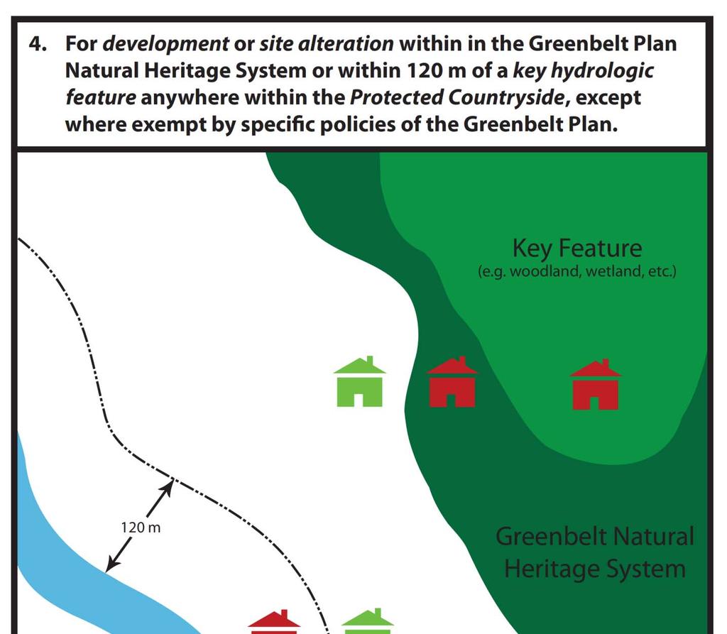
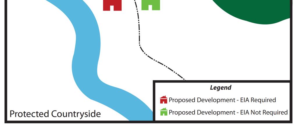
9 1.0 Introduction 1.1 Purpose This EIA Guideline provides direction to the proponents of development to determine when an EIA is required and to identify the recommended procedure for completing an EIA. These EIA Guidelines were revised from the 2005 version to comply with the policy direction in the Halton Region Official Plan Amendment No. 38 (ROPA 38), to conform to provincial plans and legislation, including the Growth Plan for the Greater Golden Horseshoe (2006), Provincial Policy Statement (2005), the Greenbelt Plan (2005) and Ontario s Endangered Species Act (2007), and to reflect the current science in environmental protection. The guidelines include words with defined meanings as per ROPA 38, the Provincial Policy Statement (2005), the Niagara Escarpment Plan (2005) and the Greenbelt Plan (2005). These words are shown in italics, and definitions are compiled in Appendix J for ease of reference. ROPA 38 applies a systems approach to protecting and enhancing natural features and functions within the Region, by implementing a Regional Natural Heritage System (RNHS). The RNHS is scientifically structured on the basis of the following components: key features; enhancements to the key features including Centres for Biodiversity; linkages; and buffers. The goal of the RNHS is to increase the certainty that the biological diversity and ecological function within Halton will be preserved and enhanced for future generations. The requirement for an EIA is specified within section 141 of ROPA 38 Part IV Healthy Communities Policies. It is the policy of the Region to: 141(2) Require the proponent of any development in certain areas or under certain conditions as specified in the Plan, to carry out an EIA; and 141(3) Provide guidelines for carrying out EIAs. The purpose of an EIA is to demonstrate that a proposed development will result in no overall negative impacts to the functions and features of that portion of the RNHS affected by the development. This will be completed by identifying natural features, functions and values and assessing the potential environmental impacts, requirements for impact avoidance and mitigation measures, and opportunities for enhancement. Within rural areas of Halton Region, agricultural land use and the RNHS coexist; the RNHS is not intended to restrict normal farm practices. 1.2 When an EIA Is Required The need for an EIA and the scope of work to be undertaken will be determined by the Region in consultation with other relevant planning approval authorities and agencies. As part of the pre-consultation phase (see section 2.1 below) a coordinated site visit may be necessary to confirm the requirement for an EIA. In accordance with the policy direction in ROPA 38, Halton Region requires an EIA in the following circumstances: 1
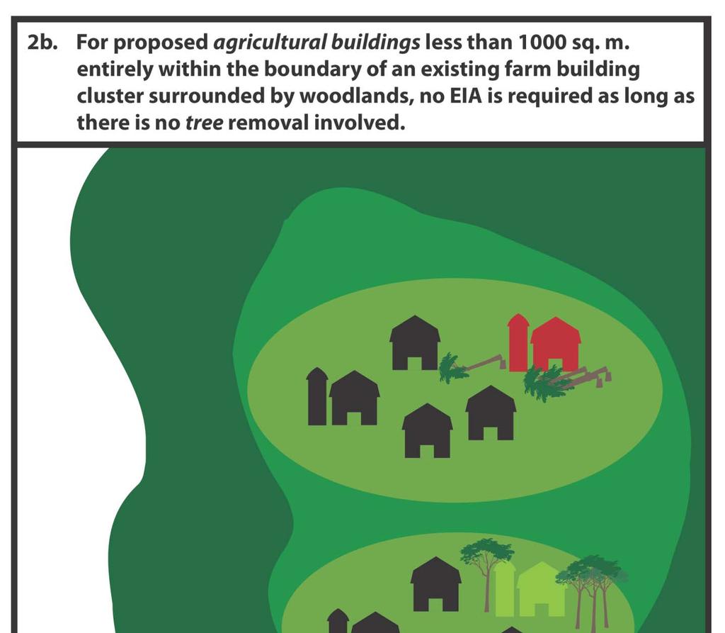
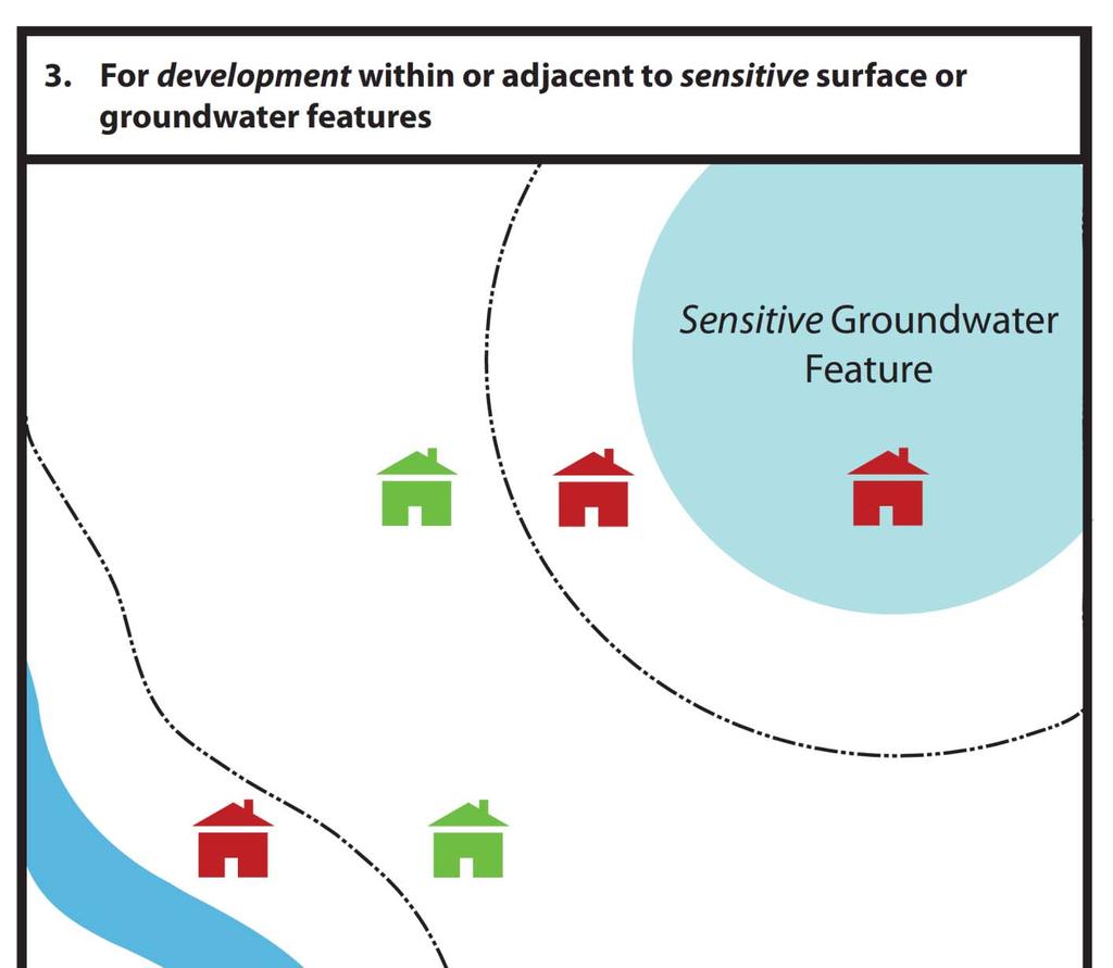
10 1. For development within or adjacent to the RNHS For any development, including public works, that is located wholly or partially inside or within 120 m of the Regional Natural Heritage System, unless: a) it is a use conforming to the Local Official Plan and permitted by Local Zoning By-laws; b) it is a use requiring only an amendment to the Local Zoning By-law and is exempt from this requirement by the Local Official Plan; or c) exempt or modified by specific policies of ROPA For proposed agricultural buildings or single detached dwellings on existing lots and their incidental uses, within or adjacent to the RNHS a) For proposed agricultural buildings with a footprint not exceeding 1,000 sq m or single detached dwellings on existing lots and their incidental uses, the requirement for an EIA is reduced to only where the proposed building is located wholly or partially inside or within 30 m of any Key Feature of the Regional Natural Heritage System. b) If the proposed agricultural building is located entirely within the boundary of an existing farm building cluster surrounded by woodlands, no EIA is required as long as there is no tree removal involved. c) For proposed agricultural buildings with a footprint over 1,000 sq m, the requirement for EIA is reduced to only where the proposed building is located wholly or partially inside or within 30 m of the RNHS. 3. For development within or adjacent to sensitive surface or groundwater features For development in or near sensitive surface water or ground water features, the need for an EIA will be determined by the Region on a case by case basis and will depend on the sensitivity of the surface and/or groundwater feature(s) and the type of development proposed. ROPA 38 provides policy direction through Section 145(23). 4. For development or site alteration within in the Greenbelt Plan Natural Heritage System or within 120 m of a key hydrologic feature anywhere within the Protected Countryside, except where exempt by specific policies of the Greenbelt Plan. A series of figures illustrating the above noted EIA triggers is provided in Appendix A. 1.3 Planning Approval Authority and Agency Roles A development application must conform to the applicable planning requirements established by planning approval authorities and agencies (provincial, regional and local municipalities, Niagara Escarpment Commission, Conservation Authorities) for conducting an assessment of the impact of development on natural features and functions. The completion and approval of an EIA may be part of the requirement for granting of development approvals. If it is determined that an EIA is required, an application can only be considered complete following the submission of the Draft EIA in accordance with the approved terms of reference (ToR). It is not the intent of Halton Region s EIA to duplicate similar studies either recently completed or required by other agencies. It is anticipated that Halton Region s EIA will be coordinated with other agencies such as Local Municipalities, Conservation Authorities and the Niagara Escarpment Commission to avoid duplication of effort and to ensure that all agency requirements can be addressed through a one study process. To facilitate this, the EIA will be coordinated by the planning approval authority to which the development application is 2
11 submitted, referred to here as the lead planning approval authority. Depending on the nature of a development application, joint applications may be necessary. In these instances, Halton Region will work in consultation with other planning approval authorities to coordinate the EIA process. The lead planning approval authority, in consultation with other relevant planning approval authorities and agencies, should coordinate pre-consultation and scoping and development of ToR for the EIA. The lead planning approval authority will also coordinate review of the draft and final EIA report in consultation with other relevant planning approval authorities and agencies. The lead planning approval authority will ensure draft EIAs will be completed under the one study process and will demonstrate conformity with policies of respective planning approval authorities and agencies before being considered appropriate for final submission. Regional staff will ensure that Regional interests related to the identification and protection of the RNHS are addressed through the one study process. Where an EIA is triggered under Regional policy on lands contained within the RNHS and the Niagara Escarpment Plan Area the EIA process will be led by Halton Region. In areas where an additional EIA review process has been identified through a comprehensive environmental review as part of a secondary plan process, or a watershed and/or subwatershed study, and agreed to by the Region and the applicable local planning approval authority, the Region will work in consultation with the local municipality to coordinate the additional EIA process and ensure that matters of Regional concern are addressed. In lands where Species at Risk, wetlands, Areas of Natural and Scientific Interest, and/or natural hazards identified in the PPS are present, there will be a need for proponents of a development to consult with the Ontario Ministry of Natural Resources Aurora District office, Conservation Authority, Department of Fisheries and Oceans and/or Environment Canada during the EIA process. It is strongly recommended that the lead planning approval authority facilitate consultation with these agencies as early in the process as possible. Contact information for the planning approval authorities and agencies referred to above is provided in Appendix B. 1.4 Role of the Proponent The proponent should become familiar with the planning process associated with the submission of a development application, particularly relevant plans, policies, and supporting documents related to environmental protection. Halton Region staff can assist in directing proponents to relevant documents. Communication between the proponent and planning approval authority and/or agency staff at all stages in the EIA process will enable a proponent to meet EIA requirements in a cost effective and timely manner. Early consultation with applicable approval authorities and agencies will also be beneficial. Contact information for the various planning approval authorities and agencies that may be involved in an EIA is provided in Appendix B. Proponents should understand that completing/preparing an EIA is an iterative process involving several steps and potentially involving the collection of comprehensive field data collected at different times of the year. In some cases, proponents may need to wait for the appropriate season to collect important field data, such as data on amphibians collected from March to July or on breeding birds collected during the breeding bird season, etc. The timing for the completion of an EIA will therefore be tied, in part, to required field data collection and the appropriate time of year for such field data collection. In order to complete an EIA, the proponent needs to engage science experts from disciplines specific to areas to be studied and this may include wildlife biologists, fisheries biologists, botanists, hydrogeologists, and 3
12 ecologists. In some cases, the Region may wish to verify the qualifications of persons who are involved in carrying out an EIA, such as educational qualifications, experience, special certification (e.g. Ecological Land Classification, Wetland Evaluation, electro-fishing, etc.). Proponents should also be aware that research permits may be required from provincial and federal government ministries prior to conducting certain studies (e.g. MNR License to collect fish for scientific purposes, MNR Wildlife Scientific Collector s Authorization, Species At Risk Act research permit, etc.), and that these permits may take several months to obtain. All qualified professional consultants required to complete an EIA in accordance with these guidelines shall be retained at the expense of the proponent. 1.5 Agricultural Buildings Halton Region recognizes the importance of agriculture to the vitality of the Region, and recognizes the important contribution that rural land owners make to the preservation of natural heritage features on their lands. The RNHS was developed to ensure that a system of key features, enhancements to key features, linkages and buffers has been identified that is sufficiently robust to withstand the more intense ecological impacts associated with a change from rural to urban land use and thereby achieve long term protection of biodiversity. Halton Region recognizes that within rural areas of Halton Region, agriculture and the RNHS can coexist, and the policies of ROPA 38 are intended to support continued viability of farms while avoiding/minimizing impacts to the RNHS and its key features. ROPA 38 achieves this balance through modified EIA triggers for proposed agricultural buildings, and through a commitment to assist the proponent in carrying out an EIA required for an agricultural building under Section 118(3.1) through EIA scoping and/or by providing financial aid and/or in-kind service. Appendix C provides a checklist to assist the proponent in understanding when an EIA is triggered under Regional policies, identifies typical minimum EIA study requirements, and provides a checklist for determining what review may be required based on the nature and location of a proposed agricultural building. The requirement to complete an EIA and the required scope of work will be confirmed and assisted by Halton Region on a case by case basis. If an EIA is triggered under Section 118(3.1), Regional staff may assist the proponent through provision of the following in-kind services, as staffing capacity allows: Undertake background information review to identify known locations of key features of the RNHS on and adjacent to the proponents property. Prepare mapping in accordance with the typical minimum EIA requirements for proposed agricultural buildings, as identified in Appendix C. Obtain Ecological Land Classification (ELC) mapping for the subject property (where available) or undertake desktop ELC mapping. Coordinate a site visit with other relevant agencies to advise the proponent on building locations that would avoid triggering the requirement to complete an EIA or avoid or minimize impacts to the RNHS such that the scope of study is reduced altogether. Undertake staking and/or survey of key features of the RNHS or the disturbance envelope associated with the proposed building in consultation with other agencies to inform and verify study/setback requirements. If an EIA cannot be waived the Region may provide financial support. The level of financial support will be determined on a case by case basis. 4
13 2.0 Recommended Procedures The following procedure outlines the recommended steps to confirm the requirement to conduct an EIA, determine specific study requirements and obtain approval of the EIA document. A flow chart summarizing the recommended procedure is provided in Appendix D. 2.1 Pre-consultation Prior to the submission of an application for development, the proponent is required to pre-consult with the planning approval authority to which the development application is being submitted.. The pre-consultation may involve other agencies affected by the proposal. The planning approval authority if not the Region will notify other appropriate authorities and agencies that may be involved in the environmental impact assessment process so that they participate in the pre-consultation process and attend pre-consultation meetings. As part of pre-consultation and/or scoping, relevant authorities and agencies may conduct reconnaissance site visit(s) to better understand natural features and functions present within and adjacent to the proposed development site. If an EIA is triggered, submission of a satisfactory EIA, completed in accordance with an approved ToR, will be a requirement of a complete application for a proposed development. Pre-consultation is intended to achieve the following: a) Confirm that the requirement to complete an EIA is triggered by policies of ROPA 38 as summarized in Section (Screening). b) Establish a time line to undertake the required studies and the approval process to be followed including the need for additional meetings. c) Begin the process of identifying sources of existing information, the nature of the information required, and the data collection and analysis methods expected to complete an EIA. d) Establish, typically through preparation of an approved ToR, all planning approval authority and agency requirements as summarized in Section (Scoping) Screening Screening is the process by which the planning approval authority/agency reviews a proposal to determine if the requirement for an EIA is triggered. To determine if an EIA is required in accordance with ROPA 38, Halton Region staff will apply the policies summarized in Section 1.2 When an EIA is required. Local Municipalities, conservation authorities and the Niagara Escarpment Commission may also review the proposal to determine if a similar study is triggered in accordance with their requirements. A site meeting may be required to inform the determination Scoping Scoping is an important step in the EIA study process. It refers to the exercise by which the proposed development is evaluated to establish the extent of work required for an EIA study. The scale and scope of the EIA study is dependent on the scale and scope of the proposal, its relationship to adjacent land uses, and the type of planning approval required, and will generally be determined by the planning approval authority in consultation with other agencies. Halton Region recognizes the importance of scoping, to be conducted on a case-by-case basis, and will work with the proponent to identify the appropriate study requirements to address the development proposed. The EIA study requirements established in subsequent sections of this guideline will be applied when appropriate as established through the scoping exercise. Smaller scale development proposals will be appropriately scoped to avoid placing an undue burden on the proponent. 5
14 Halton Region is committed to assisting the proponent of a proposed agricultural building in scoping an EIA to establish the appropriate study requirements. In scoping an EIA, Halton Region staff in consultation with other relevant planning approval authorities and advisory agencies will consider, on a case-by case basis, the following in determining the type and extent of work required: a) the likely significance of the RNHS features and functions in the area of the proposed development; b) the boundary of the area(s) to be included in the EIA; c) the scale of the development and the magnitude of potential negative impacts; d) the availability of detailed sub-watershed studies and/or other field work which reflect current conditions to avoid unnecessary duplication of effort where inventories and studies have been completed within the past five years or where studies are currently underway and the timing of their completion satisfies the requirements of the EIA process; e) the presence of areas with special designation, such as Areas of Natural and Scientific Interest (ANSI) or Environmentally Sensitive Areas (ESA), noting the specific attributes and rationale for the designation; f) the presence or potential presence of provincially designated Species at Risk (SAR) and/or their habitat including endangered, threatened and special concern species as well as the presence of provincially, regionally and locally rare species (note: in addition to consulting the Natural Heritage Information Centre (NHIC) database proponents should contact the MNR Aurora District SAR Biologist to obtain the most current information); g) the presence of federally designated SAR and their critical habitat, protected under the Canada Species at Risk Act (SARA), where protection applies (in accordance with the requirements of SARA). h) the presence of Woodland patches 0.5 ha or larger, which requires the proponent to apply Halton Region s Significant Woodland criteria to determine significance and identify/confirm the boundaries of the Woodland. i) the presence of wetlands, including Provincially Significant Wetlands (PSW), Evaluated Wetlands and Unevaluated Wetlands; j) the presence or potential presence of Significant Wildlife Habitat; k) the presence of Significant Valleylands; l) the presence of Key Natural Heritage Features and/or Key Hydrologic Features as defined by Greenbelt Plan policies and supporting technical papers; m) the likely presence of surface water and groundwater features and functions (in consultation with Halton Region staff, the proponent may be referred to the Region s Guidelines for Hydrogeological Studies and Best Management Practices for Water Protection, if applicable); n) the presence of linkage and enhancement areas; and, o) specific data collection methods and data analysis protocols required, including the need for a multiseason biophysical inventory. A summary of potential data collection methods and references is provided in Appendix E. During the completion of the EIA, features and/ or functions unanticipated during the scoping exercise may be discovered. If this occurs, the proponent should contact the relevant planning approval authority or agency as soon as possible to determine if additional studies may be required Submission and Approval of Terms of Reference Based on pre-consultation, scoping and the resulting direction on the required content of the EIA, the proponent will submit a draft ToR for the EIA to the lead planning approval authority. The lead planning approval authority, in consultation with the other planning approval authorities and agencies will review the draft ToR and may provide comment to the proponent regarding modifications necessary to ensure all study 6
15 requirements are addressed. The proponent will revise and resubmit the draft ToR to address planning approval authority and agency comments. Iterative submission and review of the draft ToR may be necessary to achieve a ToR that is acceptable to all parties. The lead planning approval authority, in consultation with the other planning approval authorities and agencies as established through the one study process, will provide final approval of the ToR for the EIA. At this time the proponent may proceed to undertake the necessary studies. In some cases season-specific field studies are likely to be required (e.g amphibian calling or breeding bird surveys). In these instances and to avoid waiting for the next appropriate study season, the proponent may conduct these studies adhering to accepted field methods prior to receiving final approval of the ToR, 2.2 Delineation and Refinement of the RNHS Boundary The RNHS is shown on Map 1 of ROPA 38 (Appendix F) based on digital geographic information available for the individual components of the RNHS at the time of plan preparation. This boundary is considered sufficiently accurate to determine when an EIA is required based on the policies of ROPA 38, however final adjustment of the RNHS boundary will be required based on detailed field data collection. Delineation and refinement of Key Features of the RNHS as shown on Map 1G of ROPA 38 (Appendix F) will be based on generally accepted methodologies (e.g. wetland limit flagging and survey based on the Ontario Wetland Evaluation System and woodland dripline flagging and survey, to be undertaken in consultation with relevant review agencies). Sustainable Halton Report 3.02 (Natural Heritage System Definition & Implementation [North-South Environmental Inc. 2009]) recommends the following minimum buffers to Key Features of the RNHS: 30 m from woodlands and wetlands; and, 30 m on either side of watercourses. The delineation and refinement of Linkages and Enhancements to Key Features (including Centres for Biodiversity) should be undertaken using a systems approach. A systems approach will ensure that refinement of these components of the RNHS will be undertaken through an examination of ecological features, functions and linkages at local and regional geographic scales and in the context of short and long term ecological needs of the (RNHS. The Sustainable Halton Report 3.02 (Natural Heritage System Definition & Implementation; North-South Environmental Inc. 2009) provides additional direction regarding best practices and includes a discussion of flexibility in delineating these features, including recommended minimum widths for local and regional linkages, and recommended size thresholds to guide delineation of Enhancements to Key Features. It is anticipated that final delineation of Linkages and Enhancements to Key Features will occur if/when a change from rural to urban land use is proposed, and that this will occur through boundary adjustments to components of the RNHS during detailed land use planning exercises (e.g. secondary plans). 2.3 Draft EIA When all data collection and analysis is completed a draft EIA should be prepared by the proponent in accordance with the approved ToR and be submitted to Halton Region or the lead planning approval authority for review. The lead planning approval authority will specify the number of copies required for review by Halton Region and other relevant planning approval authorities and agencies. The lead planning approval authority will coordinate review of the draft EIA. Planning approval authorities and agencies involved in the EIA would provide comments to the proponent to be considered/addressed in the final EIA. The lead planning approval authority or other planning approval authorities/agencies may request that the proponent attend a meeting to discuss the draft EIA. 7
16 Where a development triggers an EIA, an application can only be considered complete following the submission of the Draft EIA to the lead planning approval authority in accordance with the approved ToR. To be considered acceptable by Halton Region and to be considered a complete application, the draft EIA should provide: a) Confirmation that the study has been completed in accordance with an approved ToR, with the ToR included as part of the appendices; b) principal author of the report, curricula vitae and firm s name; c) a list of contributing technical field staff and curricula vitae; d) a list of all agencies and individuals contacted during report preparation; e) hard copies of the EIA printed on 8.5 x 11 inch double sided paper and digital copies; f) bibliography of literature cited; g) all data compiled and collected in approved hard copy and/or digital format (format to be specified by Halton Region); h) digital GIS files used in the preparation of figures showing the RNHS, natural features and functions, boundary survey, which where appropriate, have been confirmed by a Municipal or Conservation Authority staff person; and, i) copies of all field survey data sheets such as ELC data sheets, fish habitat mapping, etc. 2.4 Final EIA Based on the comments received from Halton Region and other agencies, the proponent should prepare a final EIA. This may include addenda to the draft EIA and if appropriate a revised development proposal and/or appropriate conditions of approval, which incorporate the final EIA recommendations. The lead planning approval authority, in consultation with the other relevant planning approval authorities and agencies, will provide final approval of the EIA. Halton Region staff will consider the final EIA in preparing comments on the development proposal. In preparing comments, Halton Region staff will consider how the EIA demonstrates compliance with relevant Federal, Provincial and Regional policy and legislation related to environmental protection including but not limited to the Planning Act, the Provincial Policy Statement, The Greenbelt Act/Plan, the Niagara Escarpment Act/Plan, the Conservation Authorities Act and associated policy/guideline documents, the Endangered Species Act, the Species At Risk Act, the Fisheries Act, the Migratory Birds Convention Act, ROPA 38 and Local Municipal Official Plans. Proponents should note that while an approved EIA is a pre-condition for development approval, an approved EIA does not secure or guarantee the approval of a development application. Proponents should note the Halton ROPA 38 policy requirement regarding an approved EIA: 118(4) Require that the recommendations of an Environmental Impact Assessment, including the placement of lot lines and structures, carried out under Section 118(3) and endorsed by the Region be implemented through official plan amendments, zoning by-laws, site plan control, conditions of planning approval or regulations by the appropriate authority. 8
17 3.0 Contents of an EIA The following sections provide direction regarding the recommended content of a typical EIA. The actual studies and information required for completion of an EIA will be determined on a case-by-case basis through scoping and submission/approval of the Terms of Reference. 3.1 Introduction a) Describe briefly the site location, existing land use and the development proposed (these are described in detail in subsequent sections); b) Outline the study area boundary and the rationale for the extent of the study; c) Identify the reason for conducting the EIA (i.e. the Regional Official Plan policy requirement and the portion of the RNHS triggering the EIA); and, d) Refer to and describe the agreed list of scoped issues and tasks based on the approved ToR. Include the approved ToR as an appendix to the EIA. 3.2 Approach a) Summarize existing information and identify data gaps; b) Provide a detailed description of all field study and data analysis methods used; c) Provide date and time (including start and stop time), purpose/target species, weather conditions and personnel involved for all field work conducted; d) Outline what policy review was undertaken; and, e) Document (including dates and names) consultations undertaken with agencies and the public (if any). 3.3 Biophysical Inventory Prepare a complete biophysical inventory which reflects current conditions based on existing information sources and/or field inventory by following the recommended methods and protocols outlined in Appendix E. The biophysical inventory should include all natural heritage areas, features and functions present on-site, present on adjacent lands and present within areas as defined by the agreed boundary of the study area(s), determined through scoping of the EIA during pre-consultation. Clearly distinguish data used from existing studies from data collected by the proponent. The extent of inventory work required will be based on the approved TOR developed in the scoping process. The proponent should prepare report figures that clearly and accurately show the location of natural features and where possible natural functions, overlaid on geographically corrected, most up to date aerial photography (orthoimagery) of the subject property (note: on reports intended for public distribution the locations of individual endangered and/or threatened species should be shown using a large (1 km 2 ) open polygon on report figures; the exact point locations of individual endangered and/or threatened species may be provided to agencies that have undergone MNR data sensitivity training). Planning approval authorities and agencies may request submission of mapped information in a digital format to be specified by the requestor. Information compiled on natural features and functions to be overlaid on report figures may include the following: a) Regional Natural Heritage System and Environmentally Sensitive Areas (as defined by Halton Region); b) Niagara Escarpment Plan Area land use designations such as Escarpment Natural Area, Escarpment Protection Area and Escarpment Rural Area, etc.; 9
18 c) Greenbelt Plan related information such as the Greenbelt Area and the Greenbelt Natural Heritage System, including Key Natural Heritage and Key Hydrologic Features following guidelines provided by the Province for the identification of these areas and features; d) Conservation Authority related information such as the Regulation Limit, floodline, and hazard lands, etc.; e) Provincial and Regional Life and Earth Science Areas of Natural and Scientific Interest (ANSI); f) PSW, Evaluated Wetlands, Unevaluated Wetlands and Coastal Wetlands; g) Habitat of Species at Risk (SAR) in Ontario/Canada including Endangered, Threatened, and Special Concern species, and Provincially and Regionally and Locally Rare Species and Plant Communities; h) Significant Wildlife Habitat for plants or animals; i) Woodlands 0.5 ha or larger and Significant Woodlands as defined using Region of Halton criteria; j) Significant Valleylands; k) Fish species present and fish habitat including relevant watercourse flow, thermal regime, channel and riparian characteristics; l) Landforms including, slope features (such as steep slopes, toe of slope, slope crest, etc.), soil type, karst features (such as sink holes, etc.), geological and topographical features (such as terraces, cliffs, outcrops, shorelines, glacial features, etc.) and contour lines; m) Surface water features and functions including lakes, reservoirs, ponds (natural and dug ponds), catchment areas, seepages, drainage features (such as permanent, seasonal and intermittent streams and rivers, swales, dug drains, etc.), location of culverts and weirs, presence of dams and barriers to fish passage, and riparian wetlands; n) Geomorphic features such as erosion and deposition areas, abandoned river and stream channels, oxbows, meander belt, bankfull channel widths, etc.); o) Hydrogeological features, functions and zones including groundwater recharge and discharge areas and areas vulnerable to groundwater contamination, and the collection of baseline data using appropriate instrumentation (e.g. staff gauges, data loggers, mini-piezometers, etc.); p) Vegetation Community Types using Ecological Land Classification protocols as well as other smaller vegetation patches, including individual or groups of trees, that are not included as Vegetation Community Types using Ecological Land Classification protocols; q) Other important natural features or functions of the system, such as wildlife movement corridors, staging areas for seasonal migration of birds, insects, etc.; important winter habitat such as deeryards, snake hibernacula, etc.; important breeding areas for birds, reptiles, fish, etc. 3.4 Biophysical Analysis Complete a biophysical analysis which identifies the significance of natural features and functions present and outlines management strategies necessary for their long term protection and enhancement, including where applicable, recommendations for their inclusion in the RNHS in order to sustain natural habitat and native species biodiversity. The biophysical analysis should: a) Address current Provincial plans, policy, guidelines, technical documents and legislation such as: Provincial Policy Statement (2005); Natural Heritage Reference Manual Second Edition (NHRM 2010); Significant Wildlife Habitat Technical Guide (OMNR 2000); Significant Wildlife Habitat Decision Support System (2002); Draft Significant Wildlife Habitat Ecoregion Criteria Schedules (OMNR 2012); Ontario Wetland Evaluation System - Southern Manual (OWES) using the most recent amendments; Greenbelt Plan (2005) and Technical Papers; NEP Plan within the Niagara Escarpment Plan Area (2005); 10
19 Ontario s Endangered Species Act, 2007 and associated regulations, recovery strategies and Government Response Statements; Canada s Species At Risk Act and associated regulations and recovery documents; Fisheries Act; Halton Region Conservation Authority: Regulation of Development, Interference With Wetlands and Alterations to Shorelines and Watercourses (Ontario Regulation 162/06) and associated policy and guideline documents; Grand River Conservation Authority: Regulation of Development, Interference With Wetlands and Alterations to Shorelines and Watercourses (Ontario Regulation 150/06) and associated policy and guideline documents, and; Credit Valley Conservation: Regulation of Development, Interference With Wetlands and Alterations to Shorelines and Watercourses (Ontario Regulation 160/06) and associated policy and guideline documents; (NOTE: The proponent is encouraged to contact Halton Region to ascertain the most up-to-date version of the documents listed above) b) Determine the precise boundaries of natural features and the RNHS in consultation with Halton Region and other agency staff. The limit of some features (i.e. wetlands, physical top of bank) must be staked in the field by Conservation Authority staff and/or OMNR staff. For other features, the planning approval authority and/or agency staff may request site walks to review the final staked and surveyed boundaries of individual natural features and the RNHS boundary which would then be used in georeferenced mapping and overlaid on recent orthoimagery; c) For any Woodland 0.5 ha or larger, determine if the woodland meets one or more of the criteria for designation as a Significant Woodland as defined in the ROPA 38; d) Apply a Systems Approach that considers the importance of protecting and enhancing ecological features, ecological functions and ecological interactions in the environment; e) Use conservation biology principles and review research that provides guidance for the identification and protection of the RNHS, including key ecological features and functions, enhancements, linkages and buffers in environments where natural habitat may be impacted by proposed development; f) Evaluate the cumulative impact of the proposed development on the RNHS in the context of existing development and likely future development; and g) Prepare a figure showing constraints to development based on the results of a biophysical analysis that establishes the boundary of the RNHS and identifies other areas for protection and restoration which collectively provide long term protection of natural habitats and native biodiversity. 3.5 Development Proposal Description a) In the context of the study area, describe any alternative development proposals considered in the refinement of the final proposal (if any), rationale for the final development proposal chosen, proposed phasing of development (if any), and expected timing of development. b) Provide a preliminary site plan showing the type(s) and location(s) of proposed development accurately overlaid on geographically corrected, most recent aerial photography (orthoimagery) of the subject property. 11
20 c) Site plans should clearly show proposed set-backs, including notation that indicates distances from proposed development areas and proposed structures to lot lines and/or to environmental features and functions designated for protection. d) Describe all relevant current and proposed Provincial, Regional and Local Municipal Official Plan and Zoning By-law land use designations, policies and permitted uses affecting the subject property. e) Describe all other relevant Federal, Provincial, Conservation Authority, Regional and Local Municipal policies, existing studies and issues (e.g. servicing, stormwater management, open space dedication, transportation, hazards, and setbacks, etc.) and outline natural heritage and hydrologic designations (e.g. ESA, RNHS, recharge areas, etc.), and provide an opinion as to the ability of the development proposal to conform to these policies, requirements and guidelines. 3.6 Impact Assessment In regard to environmental impacts the EIA must meet the requirements of the PPS (2005) and ROPA 38 in regard to no negative impacts on RNHS features and ecological functions. Where statements such as no impact are used, these must be qualified with references and/or empirical data. Impact assessment should make recommendations to revise proposed development plans if necessary to avoid/minimize environmental impacts to the RNHS. Environmental impact assessment should consider all aspects of the proposed development, including issues related to engineering requirements for servicing, storm water management, and transportation etc., and the form, type and density of proposed development in regard to proposed land uses. Appendix G provides a list of potential environmental impacts that should be considered in relation to the proposed development. Impact assessment should include one or more figures which overlays the proposed development on the ecological constraints of the site. The analyses should determine the area(s) (ha) and type(s) of natural features and functions that may be directly and indirectly impacted by the proposed development. Proposed buffers and/or setbacks which will protect natural features and functions should be clearly shown on figures and the proposed land uses within set-backs, if any, including in-ground utilities, should be specified. The rationale for the proposed set-backs should be clearly outlined, including details on how proposed set-backs will achieve protection of environmental features and functions designated for protection; relevant scientific references should be cited. Where hydrologically sensitive features (e.g. permanent and intermittent streams, wetlands, kettle lakes, seepage areas and springs) may be impacted, a hydrological evaluation should be conducted to determine the pre and post-development water balance to ensure protection of these features through appropriate design of the proposed development including the use of low impact development approaches and appropriate stormwater management. Impact assessment should provide an explanation of the methods and approaches used to determine impacts. Where possible, the EIA should cite scientific literature supporting conclusions drawn regarding environmental impacts. An EIA must evaluate the severity of environmental impacts in the context of the significance and sensitivity of natural features and functions present by considering: a) Likelihood of occurrence of impact; b) magnitude of impact; c) geographic extent of impact; d) timing of impact; e) duration of impact; f) frequency of impact; g) reversibility of impact; and 12
21 h) cumulative effect of multiple impacts. 3.7 Mitigation Strategies Mitigation strategies are intended to lessen and avoid impacts to the RNHS and to increase the long term protection of the RNHS. Mitigation is not intended to compensate for the impact of development on one area of the RNHS by implementing mitigation measures in another area. Mitigation should be considered in the context of the overall intent of an EIA, which is to propose a development approach that both avoids impact to the RNHS and identifies areas for long term protection of natural features and functions. Describe all feasible mitigation measures and their anticipated effectiveness in maintaining the health, form and function of natural features and in reducing or eliminating potential impacts on the RNHS. Wherever possible include figures and diagrams that illustrate proposed mitigation measures and detailed methods that provide direction for implementation. As new strategies and methods for the mitigation of development impacts can be expected to continuously emerge, proponents should refer to and cite recent scientific literature that supports proposed mitigation measures. A list of potential mitigation measures is provided in Appendix H; however this is not to be considered exhaustive or prescriptive. Residual impacts that cannot be mitigated should also be described. During the construction phase of site development direct impacts can occur as a result of construction activities within and adjacent to areas designated for protection. Indirect environmental impacts to surrounding natural features and functions can also result when mitigation measures for construction activities are not implemented and/or regularly inspected. The EIA should provide a detailed outline of mitigation measures intended to eliminate or reduce construction-related impacts to areas designated for protection. Construction-related mitigation may consider for example: a) Impacts associated with construction traffic and construction activity including heavy equipment operation, re-fueling, and stockpiling of building materials; b) Impacts resulting from wind and water erosion of exposed soils, particularly on slopes that are created as a part of site grading and road construction; c) Impacts that may be associated with the timing of construction and periods of sensitive and/or high biological activity; and d) Impacts that may be associated with the construction of temporary or permanent road crossings of waterways. New urban development generally results in more people living in close proximity to natural areas. This usually constitutes a fundamental change from current land uses, which are typically agricultural. Urban development generally reduces the ability of wildlife to move among natural features and for plants to disperse to new habitat. The purpose of the RNHS is to mitigate this and preserve the existing ability of plants and animals to move throughout the landscape. Associated with new development is the potential for new and additional environmental impacts to areas designated for protection. Long term mitigation may include: a) Appropriate development setbacks, fencing, signage, trail development, street lighting, education pamphlets, restoration areas, living fences, etc for new residential development areas to address long term impacts of urban areas on the RNHS such as informal walking and biking trails, dumping of refuse, encroachment, invasive plants, lighting, etc.; b) Appropriate development setbacks, fencing, building lighting, window film treatments and new types of glass with environmentally friendly spectral qualities for new industrial and commercial development to prevent bird strikes, encroachment, improper storage of materials, noise, lighting, use of signage etc.; and 13
22 c) Landscaping using locally native, non-invasive plant material suitable for the site s conditions in areas of new urban development to reduce invasion of non-native invasive plants within natural areas, reduce maintenance costs, and provide local habitat patches. Conservation Authority landscaping guidelines may provide assistance in this regard. Mitigation strategies may also include enhancement of the RNHS within the area proposed for development. Enhancements should increase the ecological integrity and resilience of existing natural features and functions and in turn contribute to the long term protection of the RNHS. Enhancements may include, for example: a) Protection and restoration of areas that link or join fragmented natural features to form larger core areas in order to create habitat for area demanding species; b) Protection and restoration of areas that will reduce the edge to-interior ratio of natural features and thus decrease the length of the interface between natural areas and areas of development; c) Protection and restoration of areas that will increase the width of ecological corridors; and, d) Protection and restoration of water catchment areas for wetlands. The Region may consider a net environmental gain approach to the preservation and enhancement of the RNHS, based on the principles outlined in ROPA 38 policy 110(7.2), for new or expanded Mineral Resource Extraction Areas outside the Niagara Escarpment Plan area, where the proponent has demonstrated no negative impact to the features and functions of the RNHS in accordance with Provincial and Regional policies. 3.8 Monitoring Plan To ensure mitigation compliance and effectiveness, a monitoring plan for the period before construction, during construction (e.g. for sediment control, stream crossings, protection of features, etc.) and after construction, may be required for development proposals that may result in more significant impacts. The monitoring plan should include an environmental inspection plan to be conducted through all phases of development outlining what is to be monitored, the frequency of monitoring, a reporting schedule and protocols that will ensure protection of natural features and functions, including invoking stop work orders, rectifying the causes of environmental damage, and restoring areas that have been impacted by construction activities. The EIA should identify how the monitoring plan will be implemented (e.g. through site plan control, conditions of planning approval or regulations by the appropriate authority, etc.), in accordance with policy 118(4) of ROPA Conclusions Summarize the key findings of the report including biophysical inventory and analysis, assessment of impacts, impact avoidance measures, mitigation measures and opportunities for environmental enhancements. The conclusions should include a final recommendation to approve/not approve the development proposal based on the results of the study, and identify conditions of approval required to achieve no overall negative impact. 14


23 Appendix A: EIA Trigger Figures 15
24 16
25 17
26 18
27 19
28 20
29 Appendix B: Contact Information for Planning Approval Authorities and Agencies Halton Region 1151 Bronte Road Oakville, Ontario L6M 3L1 Tel: Town of Oakville 1255 Trafalgar Road Oakville, Ontario L6H 0H3 Tel: Town of Milton 150 Mary Street Milton, Ontario L9T 6Z5 Tel: City of Burlington 426 Brant Street PO Box 5013 Burlington, Ontario L7R 3Z6 Tel: Town of Halton Hills 1 Halton Hills Drive Halton Hills, Ontario L7G 5G2 Tel: Grand River Conservation Authority 400 Clyde Road PO Box 729 Cambridge, Ontario N1R 5W6 Tel: Credit Valley Conservation 1255 Old Derry Road Mississauga, Ontario L5N 6R4 Tel: Conservation Halton 2596 Britannia Road West Burlington, Ontario L7P 0G3 Tel: Ministry of Natural Resources (Aurora Office) 50 Bloomington Road Aurora, Ontario L4G 0L8 Tel: Department of Fisheries and Oceans (Central and Arctic Region) 3027 Harvester Road, Suite 304 P.O. Box Burlington, Ontario L7R 4K3 Tel: Environment Canada (Ontario Office) 4905 Dufferin Street Toronto, Ontario M3H 5T4 Tel: Niagara Escarpment Commission 232 Guelph Street Georgetown, Ontario L7G 4B1 Tel:
30 Appendix C: Screening and Scoping Checklist for Agricultural Buildings 22
31 23
32 24


33 Appendix D: EIA Procedure Flow Chart 25
34 Appendix E: EIA Methods and References The following data sources, inventory protocols and reference manuals provide important direction and detailed methods for field data collection and data analysis necessary for the completion of an EIA. Table 1 outlines optimal periods for field inventory and the preferred field inventory methods to be used for field studies commonly conducted when completing an EIA. Note that data collection requirements and protocols may be updated from time to time, and as such, the list provided below may not represent the most recent versions/editions. The proponent is encouraged to contact Halton Region to ascertain the most current versions. General References for all EIA studies: The Halton Natural Areas Inventory 2006 Volumes 1 and 2 should be considered the primary sources of information for local species status. NHIC Website (click on species) Halton Region Environmentally Sensitive Area Consolidation Report, February 2005 The Physiography of Southern Ontario; Ontario. Chapman, L.J. and D.F. Putnam Geological Survey, Special Volume 2, 270 p. Accompanied by Map P.2715 (coloured), scale 1: Conservation Authority EIS Guidelines Conservation Authority Landscaping Guidelines Environment Canada s How Much Habitat is Enough? Guidelines Evaluation, Classification and Management of Headwater Drainage Features: Interim Guidelines. Updated March Ministry of Transportation Habitat Mapping protocols Important References for Significant Species: Species at Risk Act (SARA) 2002 Regulations and Rankings federal regulations will only apply to species on federal land but these species can indicate Significant Wildlife Habitat Endangered Species Act (ESA) 2007 Species Recovery Strategies (e.g. Jefferson Salamander Recovery Strategy February 2010) and Government Response Statements as published by MNR under the ESA 2007 Natural Heritage Information Centre Database and Rarity Ranking Tables, MNR (Note: MNR District office should be contacted for the most up-to-date information) The MNR SARO website should be used to determine the provincial status of species The Species at Risk Public Registry website to determine the most up-to-date national status of species and link to relevant documents e.g. status reports, recovery strategies etc. ;(Note: the most recent status documents may not yet be on-line and consultation with Environment Canada may be required, e.g. Hooded Warbler, which has recently (2012) been assessed as Not at Risk but for which the most recent on-line status report is Significant Wildlife Habitat Technical Guide, MNR, 2000 Significant Wildlife Habitat Decision Support System 2002 Draft MNR Significant Wildlife Habitat Eco-regional Criteria Schedules - criteria for designating Significant Wildlife Habitat in Ecoregions 6E and 7E: Environmental Registry: EBR Registry Number MNR protocols for surveys for selected Species at Risk, e.g. Bobolink, Eastern Meadowlark, bat species. (request from MNR) 26
35 Natural Heritage Reference Manual. MNR, 2010 For Butternut (Juglans cinerea) follow MNR protocol for Butternut Health Assessment Earth Sciences The Physiography of Southern Ontario; Ontario. Chapman, L.J. and D.F. Putnam Geological Survey, Special Volume 2, 270 p. Accompanied by Map P.2715 (coloured), scale 1: Ontario Institute of Pedology 1985 Field Manual to Describing Soils, Third Edition Soils of Halton County: Report No. 43 of the Ontario Soil Survey. Gillespie, Wicklund and Miller Flora and Plant Communities Flora Ontario ( NHIC Website (click on species or communities) Lee et al. (1998) Ecological Land Classification System for Southern Ontario, Ministry of Natural Resources (MNR) Distribution and Status of the Vascular Plants of the Greater Toronto Area (Varga et. al. Draft 2005) Halton Natural Areas Inventory 2006 Volumes 1 and 2 (This document should be considered the primary source for local species status) Fauna Ontario Breeding Bird Atlas protocols and conventions (Cadman et al and on-line summaries at Ontario Benthos Bio-monitoring Network protocol for invertebrates Ontario Stream Assessment Protocol for fisheries and benthos, MNR: 1.pdf NHIC Website (click on species) Ontario Herpetofaunal Summary at the NHIC website: Halton Natural Areas Inventory 2006 Volumes 1 and 2 (This document should be considered the primary source for local species status) For fieldwork undertaken in addition to required monitoring protocols, the methods used for mammals, reptiles, amphibians, odonates (dragonflies and damselflies), butterflies, etc., should describe fieldwork methods used and include date, time, location, weather, crewmembers, and other incidental information such as, transects followed, animal signs (e.g. scat, hair, burrows, nests, etc), etc. Significant Species Regulations and Legislation Species at Risk Act (SARA) 2002 Regulations and Rankings Endangered Species Act (ESA) 2007 Federal Aquatic Species at Risk Act mapping available at Migratory Birds Convention Act (1994) Species Recovery Strategies (e.g. Jefferson Salamander Recovery Strategy February 2010) and Government Response Statements as published by MNR under the ESA 2007 Natural Heritage Information Centre Database and Rarity Ranking Tables, MNR (Note: MNR District office should be contacted for the most up-to-date information) 27
36 The MNR SARO website should be used to determine the provincial status of species The Species at Risk Public Registry website to determine the most up-to-date national status of species and link to relevant documents e.g. status reports, recovery strategies etc. ;(Note: the most recent status documents may not yet be on-line and consultation with Environment Canada may be required, e.g. Hooded Warbler, which has recently (2012) been assessed as Not at Risk but for which the most recent on-line status report is Commission for Environmental Cooperation (CEC) Secretariat Background Paper Monarch Butterfly Monitoring in North America: Overview of Initiatives an Protocols (2009) Fisheries Act The Environmental Registry of Ontario provides up-to-date information on recent and proposed changes in policy and legislation search keywords such as endangered or species at risk or use more specific terms Draft Guidance for Development Activities in Redside Dace Protected Habitat. MNR. February Guideline Documents Ministry of Transportation Habitat Mapping protocols Ontario Wetland Evaluation System for Southern Ontario, MNR Marsh Monitoring Protocol (Canadian Wildlife Service and Bird Studies Canada Forest Bird Monitoring Program protocol (Canadian Wildlife Service) Ontario Breeding Bird Atlas protocols (Bird Studies Canada 2001) Significant Wildlife Habitat Technical Guide, MNR, 2000 Significant Wildlife Habitat Decision Support System 2002 Draft MNR Significant Wildlife Habitat Eco-regional Criteria Schedules - criteria for designating Significant Wildlife Habitat in Ecoregions 6E and 7E: Environmental Registry: EBR Registry Number MNR protocols for surveys for selected Species at Risk, e.g. Bobolink, Eastern Meadowlark, bat species. (request from MNR) Natural Heritage Reference Manual. MNR, 2010 For Butternut (Juglans cinerea) follow MNR protocol for Butternut Health Assessment City of Toronto Bird Friendly Design Guidelines Stream Temperature Analysis Tool and Exchange (STATE) Available Fish Management Plans prepared by MNR, the CA etc. Conservation Authority EIS Guidelines Conservation Authority Landscaping Guidelines Environment Canada s How Much Habitat is Enough? Guidelines Evaluation, Classification and Management of Headwater Drainage Features: Interim Guidelines. Updated March Background Documents Halton Region Environmentally Sensitive Area Consolidation Report, February 2005 Halton Natural Areas Inventory, 2006, Hamilton Naturalists Club Appendix E Table 1: Optimal Periods for Field Inventory and Preferred Field Inventory Methods to be used in an EIA when Collecting Natural Heritage Information Notes: 28
37 For some species, repeated sampling may be required to accurately determine species presence and abundance. Please refer to preferred field inventory method to determine the optimal period for field inventory, including the appropriate hours during the day or night to conduct field work. Regulations for Endangered Species may require sampling over a period of more than one year to accurately determine species presence and abundance (see for example the Jefferson Salamander Recovery Strategy 2010) For all fieldwork undertaken, the EIA should describe fieldwork methods used and include date, time, location, weather, crewmembers, and other incidental information such as, transects followed, animal signs (e.g. scat, hair, burrows, nests, etc), etc. Natural Heritage Feature Optimal Period for Field Inventory Preferred Field Inventory Method Notes and Related References Ecological Land Classification (ELC) and vegetation inventory spring ephemerals April-June peak season flora July-August late flowering flora, particularly wetland, alvar and prairie flora August-Sept (note: spring inventory for these rare communities is also important) Ecological Land Classification System for Southern Ontario (1999) References: Flora Ontario ( NHIC Website (click on species or communities) v.on.ca/nhicweb/mainsubmit.do Oldham and Brinker (2009). Rare Vascular Plants of Ontario, Fourth Edition, NHIC. Lee et al. (1998) Ecological Land Classification System for Southern Ontario, Ministry of Natural Resources (MNR) Halton Natural Areas Inventory 2006 Volumes 1 and 2 (This document should be considered the primary source for local species status) Distribution and Status of the Vascular Plants of the Greater Toronto Area (Varga et. al. Draft 2005) Ontario Institute of Pedology 1985 Field Manual to Describing Soils, Third Edition Soils of Halton County: Report No. 43 of the Ontario Soil Survey. Gillespie, Wicklund and Miller Wetland evaluation and delineation varies - see notes optimal periods for wetland community classification, birds, fish, reptiles, amphibians, and Ontario Wetland Evaluation System for Southern Ontario (OWES) Notes; wetland community classification and delineation requires ELC and floral inventory follow protocols as outlined in this table wetland evaluation also requires inventory of mammals, birds, fish, 29
38 Natural Heritage Feature Optimal Period for Field Inventory Preferred Field Inventory Method Notes and Related References insects may have to be sampled at appropriate times of the year to determine if significant species are present reptiles, amphibians, molluscs and insects etc., where present follow protocols for these species groups as outlined in this table References: Ontario Wetland Evaluation System for Southern Ontario, MNR Mammals species dependent see notes Various - active searching, sightings, tracks, scat, hair, calls, dens, sign, photo traps, trails, live trap surveys, etc. most accurate methods highly labour intensive Notes in addition to the inventory of mammals for some species it may be necessary to consider criteria related to the identification of significant wildlife habitat see references below. References: Significant Wildlife Habitat Technical Guide, MNR, 2000 Significant Wildlife Habitat Decision Support System 2002 Draft MNR Significant Wildlife Habitat Eco-regional Criteria Schedules - criteria for designating Significant Wildlife Habitat in Ecoregions 6E and 7E: Environmental Registry: EBR Registry Number Birds the peak breeding bird season for southern Ontario used in most monitoring protocols is May 24 th to July 10 th some bird species have other breeding seasons and specialized monitoring protocols that may need to be considered (e.g. owls depending on species November to April, marsh birds depending on species April to July) Ontario Breeding Bird Atlas Ontario Breeding Bird Survey Forest Bird Monitoring Program Marsh Monitoring Program Specific MNR protocols developed for REA applications e.g. surveys for winter raptor significant habitat, waterfowl stopover habitat, Species at Risk such as Bobolink and Eastern References: Marsh Monitoring Protocol (Canadian Wildlife Service and Bird Studies Canada) Forest Bird Monitoring Program protocol (Canadian Wildlife Service) Ontario Breeding Bird Atlas protocols and conventions (Cadman et al and on-line summaries at jsp) Migratory Birds Convention Act (1994) City of Toronto Bird Friendly Design Guidelines 30
39 Natural Heritage Feature Optimal Period for Field Inventory Preferred Field Inventory Method Notes and Related References fall migrating birds may be monitored in September and October, spring migration late April to second week in May overwintering birds from December to March Meadowlark, provide guidance on level of effort required Fish fish survey late April-June redd surveys vary by species, appropriate timing should be discussed at preconsultation fish habitat during snow/ice free conditions Ontario Stream Assessment Protocol electro fishing References: Federal Aquatic Species at Risk Act mapping available at DFO/find/southwestern.html Fisheries Act The Environmental Registry of Ontario provides up-to-date information on recent and proposed changes in policy and legislation search keywords such as endangered or species at risk or use more specific terms External/ Draft Guidance for Development Activities in Redside Dace Protected Habitat. MNR. February Available Fish Management Plans prepared by MNR, the CA etc. Ontario Stream Assessment Protocol for fisheries and benthos, MNR: nts/document/ pdf Snakes April through October depending on species Spring & fall snake congregations Various - active searching, (often under debris) and road mortality surveys, knowledge of species activity patterns and habitat requirements References: Ontario Herpetofaunal Summary at the NHIC website: rps/ohs.html 31
40 Natural Heritage Feature Optimal Period for Field Inventory Preferred Field Inventory Method essential for effective surveys; location of significant habitat (breeding and hibernation) extremely sensitive refer to OMNR or CA for information; permits may be required for searching Turtles May to August basking, nesting, road mortality surveys from late spring to late summer nesting location data extremely sensitive refer to OMNR or CA for information; permits may be required for searching Amphibians species dependent - generally very early spring to summer breeding salamanders - late March-early April associated with ice melt, rain and warming soil temperatures frogs require regular evening monitoring in mild weather with little wind during early spring to summer to identify all species Frog call identification and abundance estimates using Marsh Monitoring protocols Placement of wooden boards with follow-up survey active searching of ponds for breeding salamanders during first spring thaw and rain non-intrusive egg mass surveys searches of woody debris for salamanders, Notes and Related References References: Ontario Herpetofaunal Summary at the NHIC website: s/ohs.html References: Ontario Herpetofaunal Summary at the NHIC website: ps/ohs.html Marsh Monitoring Protocol (Canadian Wildlife Service and Bird Studies Canada) 32
41 Natural Heritage Feature Optimal Period for Field Inventory Preferred Field Inventory Method Notes and Related References especially near suspected breeding ponds in early summer salamander surveys involving egg collection and/or tail snip and/or minnow trapping should only be conducted if directed by and with permit (where required) from the MNR Butterflies species dependent May to September active searching sweep net capture and release References: Commission for Environmental Cooperation (CEC) Secretariat Background Paper Monarch Butterfly Monitoring in North America: Overview of Initiatives an Protocols (2009) Dragonflies and Damselflies species dependent surveys conducted May to September single season surveys conducted mid-june active searching sweep net capture and release Benthos spring (April-May) or fall (Sept-Oct) (note inter-annual comparisons can only be made based on spring to spring or fall to fall datasets Ontario Benthos Biomonitoring Network protocols Ontario Stream Assessment Protocols References: Ontario Benthos Bio-monitoring Network protocol for invertebrates, Ver 1.0 May E3-C9C9-4D7B-9B47- B41E7B990989/OntarioBenthosBiomoni toringnetworkprotocolmanual.pdf Ontario Stream Assessment Protocol for fisheries and benthos, MNR: nts/document/ pdf Molluscs June 1 to September 30, providing water temperatures are Protocols for collection and relocation of mussels (Mackie et Notes detailed information regarding habitat requirements and life history of target species is essential in determining the 33
42 Natural Heritage Feature Water Temperature Optimal Period for Field Inventory Preferred Field Inventory Method Notes and Related References greater than 16 C al. 2008) timing, phasing, target habitats, and methods of collection appropriate search effort is critical in asserting species absence daily maximum temperature measured from July 1 to Sept 10 spot temperature measurements daily air temperature must exceed 24.5 o C on sample day must be preceded by two days with daily air temperature above 24.5 o C sample day must be preceded by three days without rainfall that could affect baseflow in the sample watercourse References: Measuring Stream Temperature Using Data Loggers MNR (2010) ume/groups/lr/@mnr/@aquatics/docum ents/document/stdprod_ pdf Thermostat ver 3 ermostat_home.htm Instruction Manual for Stream Temperature Analysis Tool and Exchange (STATE). Jones, N.E., and C. Chu River and Stream Ecology Lab, Ontario Ministry of Natural Resources, Trent University, Ontario 34

43 Appendix F: Maps from ROPA 38 Map 1 35
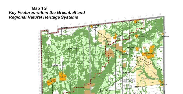
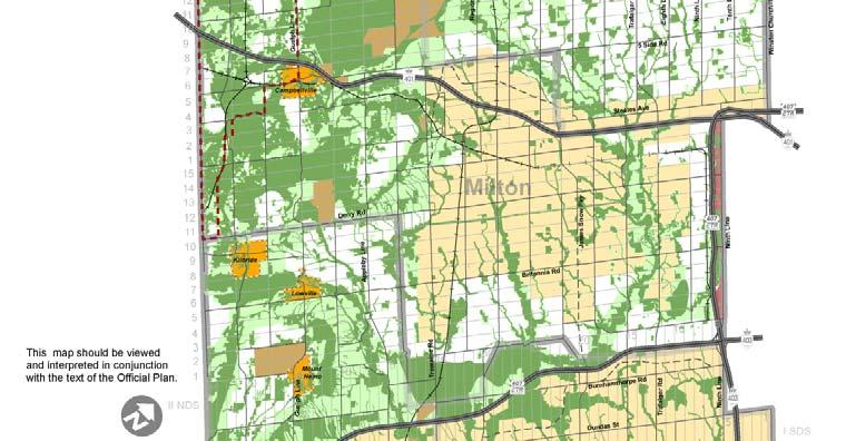

44 Map 1G 36
45 Appendix G: Potential Environmental Impacts Environmental impacts associated with development may be characterised as irreversible, short term, construction related, long-term and cumulative. Impact analysis is to be based on the scientific literature available and should build on successful approaches that ensure long term protection of the RNHS based on a systems approach to EIA in environments undergoing development. The second edition of the MNR s Natural Heritage Reference Manual Chapter 13 Addressing Impacts of Development and Site Alteration should also be consulted when considering environmental impacts. Examples of impacts that may be considered include, but are not limited to the following: 1. Fragmentation or reduction in the size of the RNHS; 2. Increase in the perimeter-to-area ratio of features within the RNHS; 3. Loss of ecological features and supporting functions of agricultural lands adjacent to the RNHS; 4. Alteration of natural disturbance cycles important to the ecological health and renewal of the RNHS, such as flooding, erosion, deposition, disease, and fire, etc.; 5. Loss or reduction in functional ecological linkage of the RNHS among natural features important for daily, seasonal and/or long term movement patterns of plants and animals; 6. Alteration of natural topography that results in impacts to the RNHS; 7. Ongoing or increased potential for human or domestic animal impacts on the RNHS, especially areasensitive species, ground-nesting birds, small mammals, reptiles and amphibians; 8. Alteration of the quantity, quality, timing (hydroperiod) or direction of flow, of surface or groundwater resulting in impacts to the RNHS; 9. Alteration of the structure, functions or ecological interrelationships of natural habitat that sustains representative community associations or species populations. 10. Reductions in the size and diversity of species populations, or the health and reproductive capacity of species; 11. Removal of vegetation communities which are structural and/or functional element of the RNHS; 12. Erosion or compaction of soils, slope failure, or deposition of sediment; 13. Increased potential for the introduction of non-native species; 14. Occupancy of lands adjacent to the RNHS resulting in increased access, pets, night lighting, escape of horticultural plants, noise, dumping of waste, air pollution, water pollution, encroachment, increased presence of humans, etc.; and 15. Harmful Alteration, Disruption or Destruction (HADD) of fish habitat pursuant to the Canada Fisheries Act. 16. Potential environmental impacts associated with aquatic environments may include: disruption or prevention of natural sediment transport regime; severing the connection of a watercourse from its floodplain; impairment or loss of fish passage through a watercourse; negative changes to the health, composition, density or type of riparian vegetation; negative changes to in-stream structure (e.g. overhanging banks, dynamic banks, hydraulic habitats that have formed over time, sand, gravel, and organic substrates); Enclosure of watercourses in underground pipes; excavation of on-line ponds; excavation of off-line pond that could be a source of thermal or water quality pollution with respect to surface and/or groundwater resources; and the lining of the banks or channel of any watercourse with hard materials. 17. Refer to Table C-1 in the NHRM (2010) for more examples of potential environmental impacts. 37
46 Appendix H: Potential Mitigation Measures Mitigation measures are intended to maintain the health, form and function of the RNHS and contribute to reducing or eliminating potential short or long term impacts from development on the RNHS. New strategies and methods for the mitigation of development impacts can be expected to continuously emerge, and as such proponents should refer to and cite recent scientific literature. Examples of mitigation measures may include but are not limited to the following: 1. Avoidance of natural features and functions; 2. Modifying or redesigning the proposal to reduce or eliminate impacts; 3. Dedication or transfer of natural areas to a public body; 4. Buffers and/or setbacks adequate to reduce impacts and preserve ecological functions along edges of natural features; 5. Measures to restore or enhance natural areas, features or functions onsite; 6. Installation of functional ecopassages for roads that cross natural areas to allow movement of resident plants and animals; 7. Construction timing restrictions to avoid critical periods such as fish spawning, herpetofauna breeding and hibernation periods, or bird breeding and nesting (May 1 st to July 31 st ), animal migration and seasons when heavy construction equipment operating on exposed soils is most likely to cause soil erosion and siltation. 8. Effective temporary stormwater management and sediment control during construction; 9. Ministry of the Environment Enhanced permanent stormwater management facilities; 10. Innovative infiltration measures suitable for the site such as infiltration trenches, porous pavements, catchment cisterns, etc.; 11. Proper collection of groundwater elevation data that will allow proponents to design development in a way that will mitigate impacts to groundwater; 12. For waterways currently impacted by past human alteration wherever possible make every effort to: daylight and restore waterways that currently exist in underground pipes; remove human created impoundments that currently exist within watercourses; and Rehabilitate hardened creek channels using natural channel design principles and techniques and Replace 13. Institute strategies to reduce salt application to roads that cross or are located adjacent to waterways; 14. Consider adoption of on-site stormwater management including green roofs; 15. Low impact development techniques; 16. Urban design guidelines that consider factors such as window treatments to prevent bird strikes, lighting that does not impact adjacent natural areas, street and lot orientation that provides additional separation from natural features; 17. Salvaging strategies for plants and animals that will be directly impacted by development; 18. Comprehensive ecological restoration plans; 19. Promotion of stewardship initiatives; 20. Detailed tree saving plans developed to maximize tree saving through careful adjustment of final development plans; 21. Installation of temporary and permanent fencing; 22. Posting securities for environmental damage repair; and 23. Promotion of public awareness through the development of homeowners guides and the creation and installation of information signage. 38
47 Appendix I: Definitions AGRICULTURAL BUILDING: is a building required for agricultural uses and/or agricultural-related uses as defined below. AGRICULTURAL USES: means the growing of crops, including nursery and horticultural crops; raising of livestock; raising of other animals for food, fur or fibre, including poultry and fish; aquaculture; apiaries; agroforestry; maple syrup production; and associated on-farm buildings and structures, including accommodation for full-time farm labour when the size and nature of the operation requires additional employment. PPS (2005) AGRICULTURAL-RELATED USES: means those farm-related commercial and farm-related industrial uses that are small scale and directly related to the farm operation and are required in close proximity to the farm operation. PPS (2005) CENTRE FOR BIODIVERSITY means an area that encompasses existing natural heritage features and associated enhancement areas and is of sufficient size, quality and diversity that it can support a wide range of native species and ecological functions, accommodate periodic local extinctions, natural patterns of disturbance and renewal and those species that are area sensitive, and provide sufficient habitat to support populations of native plants and animals in perpetuity. ROPA 38 CONSERVATION AUTHORITY means Conservation Halton (Halton Region Conservation Authority) or Credit Valley Conservation (Authority) or the Grand River Conservation Authority. CUMULATIVE IMPACT means the effect on the physical, natural, visual and cultural heritage features of the environment resulting from the incremental activities of development over a period of time and over an area. All past, present and possible feature activities are to be considered in assessing cumulative impact. ROPA 38. DEVELOPMENT means the creation of a new lot, a change in land use, or the construction of buildings and structures, any of which requires approval under the Planning Act, or that are subject to the Environmental Assessment Act, but does not include: The construction of facilities for transportation, infrastructure and utilities used by a public body; Activities or works under the Drainage Act, or The carrying out of agricultural practices on land that was being used for agricultural uses on the date the Greenbelt Plan 2005 came into effect ROPA 38 ECOLOGICAL AND ENVIRONMENTAL ADVISORY COMMITTEE (EEAC) The Ecological and Environmental Advisory Committee advises and assists the Region with respect to the management and conservation of the natural environment of Halton. (Halton Region Website ECOLOGICAL FUNCTION means the natural processes, products or services that living and non-living environments provide or perform within or between species, ecosystems and landscapes (including hydrologic functions and biological, physical, chemical and socio-economic interactions). PPS (2005) ENDANGERED SPECIES means a species that is listed or categorized as an Endangered Species on the Ontario Ministry of Natural Resources official species at risk list, as updated and amended from time to time. PPS (2005) 39
48 ENVIRONMENTALLY SENSITIVE AREAS means land and water areas within the Greenbelt and Regional Natural Heritage Systems containing natural features or ecological functions of such significance as to warrant their protection in the best long term interests of the people and environment of Halton. While the Region maintains mapping showing the general boundaries of the ESAs, precise boundaries of ESAs are to be established through an Environmental Impact Assessment (EIA). In designating ESAs, the Region will give specific regard to maintaining the long term viability of existing agricultural operations. ROPA 38 ESCARPMENT BROW means the uppermost point of the Escarpment slope or face. It may be the top of a rock cliff, of where the bedrock is buried, the most obvious break in slope associated with the underlying bedrock. ROPA 38 EVALUATED WETLAND means a wetland that has been evaluated using the criteria outlined in the Ontario Wetland Evaluation System FISH means fish, which as defined in S.2 of the Fisheries Act, c. F-14, as amended, includes fish, shellfish, crustaceans, and marine animals, at all stages of their life cycles. PPS (2005) FISH HABITAT as defined in the Fisheries Act, c. F-14, means spawning grounds and nursery, rearing, food supply and migration areas on which fish depend directly or indirectly in order to carry out their life processes. PPS (2005) FLOOD PLAIN means the area, usually lowlands, adjoining the channel of a river, stream, or watercourse which has been or may be covered by flood water during a regional flood or a one in one hundred year flood, whichever is greater. ROPA 38 GROUND WATER FEATURE: refers to water-related features in the earth s subsurface, including recharge/discharge areas, water tables, aquifers and unsaturated zones that can be defined by surface and subsurface hydrogeologic investigations. PPS (2005) HAZARD LANDS means properties or lands that could be unsafe for development due to naturally occurring processes. Along the shorelines of Lake Ontario and Burlington Bay, this means the land, including that covered by water, between a defined offshore distance or depth, and the furthest landward limit of the flooding, erosion or dynamic beach (areas of unstable accumulations of shoreline sediments) hazard limits. Along river and stream systems, this means the land, including that covered by water, to the furthest landward limit of the flooding or erosion hazard limits. ROPA 38 HYDROLOGIC FUNCTION means the functions of hydrological cycle that include the occurrence, circulation, distribution, and chemical and physical properties of water on the surface of the land, in the soil and underlying rocks, and in the atmosphere, and water s interaction with the environment including its relations to living things. PPS (2005) KEY HYDROLOGIC FEATURES means a key hydrologic feature as describe in section of the Greenbelt Plan. Key hydrologic features include; Permanent and intermittent streams; Lakes (and their littoral zones): Seepage areas and springs; and Wetlands Greenbelt Plan (2005) KEY NATURAL HERITAGE FEATURES means a key natural heritage features as described in section of the Greenbelt Plan. Key natural heritage features include: 40
49 Significant habitat of endangered species, threatened species and special concern species Fish habitat Wetlands Life Science Areas of Natural and Scientific Interest (ANSIs); Significant valleylands; Significant woodlands Significant wildlife habitat Sand barrens, savannahs and tallgrass prairies and Alvars" Greenbelt Plan (2005) NATURAL ENVIRONMENT means the air, land, water, plants, and animals, or any combination or part thereof. ROPA 38 NATURAL HERITAGE SYSTEM means a system made up of natural heritage features and areas, linked by natural corridors which are necessary to maintain biological and geological diversity, natural functions, viable populations of indigenous species and ecosystems. These systems can include lands that have been restored and areas with the potential to be restored to a natural state. PPS (2005) NEGATIVE IMPACTS means a) in regard to policy 2.2 (of the PPS 2005), degradation to the quality and quantity of water, sensitive surface water features and sensitive ground water features, and their related hydrologic functions, due to single, multiple or successive development or site alteration activities. b) in regard to fish habitat, the harmful alteration, disruption or destruction of fish habitat, except where, in conjunction with the appropriate authorities, it has been authorized under the Fisheries Act, using the guiding principle of no net loss of productive capacity; and a) c)in regard to other natural heritage features and areas, degradation that threatens the health and integrity of the natural features or ecological functions for which an area is identified due to single, multiple or successive development or site alteration activities. PPS (2005) NORMAL FARM PRACTICE means a practice that: a) is conducted in a manner consisten with proper and acceptable customs and standards as established and followed by similar agricultural operations under similar circumstances, or b) makes use of innovative technology in a manner consistent with proper advanced farm management practices. If required, the determination of whether a farm practice is a normal farm practice shall be in accordance with the provision of the Farming and Food Production Protection Act, including the final arbitration on normal farm practices by the Farm Practices Protection Board under the Act. ROPA 38 PROVINCIALLY SIGNFICANT AREAS OF NATURAL AND SCIENTIFIC INTEREST means areas of land and water containing natural landscapes or features that have been identified as having life science or earth science values related to protection, scientific study, or education. PPS (2005) PROVINCIALLY SIGNIFICANT WETLANDS means wetlands so classified by the Ministry of Natural Resources based on the Ontario wetland evaluation System 1994 Southern Manual, as amended from time to time. ROPA 38 RECOVERY STRATEGY Recovery strategies provide science-based recommendations for the Minister of Natural Resources and other interested parties on the protection and recovery of endangered and threatened species. 41
50 REGULATORY FLOOD means the approved standard(s), a regional flood or a one in one hundred year flood, used in a particular watershed to define the limit of the flood plain for regulatory purposes. SENSITIVE: in regard to surface water features and ground water features, means areas that are particularly susceptible to impacts from activities or events including, but not limited to, water withdrawals, and additions of pollutants. PPS (2005) SIGNIFICANT WOODLAND means a Woodland 0.5 ha or larger determined through a Watershed Management Plan, a Subwatershed Study or a site-specific Environmental Impact Assessment to meet one or more of the four following criteria: (1) The Woodland contains forest patches over 99 years old, (2) The patch size of the Woodland is 2 ha or larger if is located in the Urban Area, or 4 ha or larger if it is located outside the Urban Area but below the Escarpment Brow, or 10 ha or larger if it is located outside the Urban Area but above the Escarpment Brow (3) The Woodland has an interior core area of 4 ha or larger, measured 100m from the edge or (4) The Woodland is wholly or partially within 50m of a major creek or certain headwater creek or within 150m of the escarpment brow. ROPA 38 SINGLE DETACHED DWELLING means a separate building containing not more than one dwelling unity and may include a chalet, cottage, or mobile home. (ROPA 38) SITE ALTERATION means activities, such as grading, excavation and the placement of fill that would change the landform and natural vegetative characteristics of a site. PPS (2005) SPECIES OF SPECIAL CONCERN A species with characteristics that make it sensitive to human activities or natural events. MNR Species at Risk website (2012). SPECIES AT RISK IN ONTARIO A species at risk is any naturally-occurring plant or animal in danger of extinction or of disappearing from the province. Once classified as "at risk", they are added to the Species at Risk in Ontario (SARO) List. MNR Species at Risk Website (2012) SRANK Provincial (or Subnational) ranks are used by the Natural Heritage Information Centre to set protection priorities for rare species and natural communities. These ranks are not legal designations. Provincial ranks are assigned in a manner similar to that described for global ranks, but consider only those factors within the political boundaries of Ontario. By comparing the global and provincial ranks, the status, rarity, and the urgency of conservation, needs can be ascertained. The NHIC evaluates provincial ranks on a continual basis and produces updated lists at least annually. Natural Heritage Information Centre Website (2012) SX Presumed Extirpated Species or community is believed to be extirpated from the nation or state/province. Not located despite intensive searches of historical sites and other appropriate habitat, and virtually no likelihood that it will be rediscovered. SH Possibly Extirpated (Historical) Species or community occurred historically in the nation or state/province, and there is some possibility that it may be rediscovered. Its presence may not have been verified in the past years. A species or community could become NH or SH without such a year delay if the only known occurrences in a nation or state/province were destroyed or if it 42
51 had been extensively and unsuccessfully looked for. The NH or SH rank is reserved for species or communities for which some effort has been made to relocate occurrences, rather than simply using this status for all elements not known from verified extant occurrences. S1 Critically Imperilled Critically imperilled in the nation or state/province because of extreme rarity (often 5 or fewer occurrences) or because of some factor(s) such as very steep declines making it especially vulnerable to extirpation from the state/province. S2 Imperilled Imperilled in the nation or state/province because of rarity due to very restricted range, very few populations (often 20 or fewer), steep declines, or other factors making it very vulnerable to extirpation from the nation or state/province. S3 Vulnerable Vulnerable in the nation or state/province due to a restricted range, relatively few populations (often 80 or fewer), recent and widespread declines, or other factors making it vulnerable to extirpation. S4 Apparently Secure Uncommon but not rare; some cause for long-term concern due to declines or other factors. S5 Secure Common, widespread, and abundant in the nation or state/province. SNR Unranked Nation or state/province conservation status not yet assessed. SU Unrankable Currently unrankable due to lack of information or due to substantially conflicting information about status or trends. SNA Not Applicable A conservation status rank is not applicable because the species is not a suitable target for conservation activities. S#S# Range Rank A numeric range rank (e.g., S2S3) is used to indicate any range of uncertainty about the status of the species or community. Ranges cannot skip more than one rank (e.g., SU is used rather than S1S4). SURFACE WATER FEATURE refers to water-related features on the earth s surface, including headwaters, rivers, stream channels, inland lakes, seepage areas, recharge/discharge areas, springs, wetlands, and associated riparian lands that can be defined by their soil moisture, soil type, vegetation or topographic characteristics. PPS (2005) SYSTEMS APPROACH means a comprehensive approach to natural heritage system planning that considers the importance of maintaining and protecting ecological features in the environment (such as woodlands, wetlands and watercourses) ecological functions of the environment (such as water storage and water quality enhancement by wetlands, winter deer yards provided by cedar woodlands, amphibian breeding habitat in ephemeral forest ponds, etc.) and ecological interactions that occur over varying scales of time and space (such as animal predation and herbivory, the daily, seasonal and long term movement patterns of plants and animals, and the role of ecological disturbance mechanisms such as fire, wind, water and disease). THREATENED SPECIES means a species that is listed or categorized as a Threatened Species on the Ontario Ministry of Natural Resources official species at risk list, as updated and amended from time to time. PPS (2005) 43
52 TREE means any species of woody perennial plant, including its root system, which has reached or can reach a height of at least 4.5m above ground at physiological maturity. ROPA 38 UNEVALUATED WETLAND means a wetland that has not been evaluated using the criteria outlined in the Ontario Wetland Evaluation System WETLANDS means lands that are seasonally or permanently covered by shallow water, as well as lands where the water table is close to or at the surface. In either case, the presence of abundant water has caused the formation of hydric soils and has favoured the dominance of either hydrophytic or water tolerant plants. The four major types of wetlands are swamps, marshes, bogs and fens. Periodically soaked or wet lands being used for agricultural purposes which no longer exhibit wetland characteristics are not considered to be wetlands for the purposes of this definition. ROPA 38 WILDLIFE HABITAT means areas where plants, animals and other organisms live and find adequate amounts of food, water, shelter and space needed to sustain their populations. Specific wildlife habitats or concern may include areas where species concentrate at a vulnerable point in their annual or life cycle, and areas which are important to migratory or non-migratory species. PPS (2005) WOODLAND means land with at least: 1000 trees of any size per ha, or 750 trees over 5 cm in diameter per ha, or 500 trees over 12 cm in diameter per ha, or 250 trees over 20 cm in diameter per ha but does not include an active cultivated fruit or nut orchard, a Christmas tree plantation, a plantation certified by the Region, a tree nursery, or a narrow linear strip of trees that define a laneway or a boundary between fields. For the purpose of this definition, all measurements of the trees are to be taken at 1,37 meters from the ground and trees in regenerating fields must have achieved that height to be counted. ROPA 38 44
53


54
City of Mississauga Environmental Impact Studies Terms of Reference 2002
 City of Mississauga Environmental Impact Studies Terms of Reference 2002 1.0 INTRODUCTION To ensure in so far as possible, both private and public developments are consistent with Natural Heritage and
Golf Course and Recreational Facilities Best Management Guidelines. Regional Official Plan Guidelines
 Golf Course and Recreational Facilities Best Management Guidelines Regional Official Plan Guidelines Halton Region Official Plan Guidelines The Regional Official Plan (ROP) is Halton s guiding document
ENVIRONMENTAL IMPACT STUDY GUIDELINES
 ENVIRONMENTAL IMPACT STUDY GUIDELINES Version 1 September, 2012 Section 1 Environmental Impact Study Overview TABLE OF CONTENTS What is an Environmental Impact Study (EIS) and What is its Purpose?.....................................
CATEGORY a protection of the natural environment, its ecosystems and biodiversity.
 29. ENVIRONMENTAL DEVELOPMENT PERMIT AREA CATEGORY a protection of the natural environment, its ecosystems and biodiversity. The requirement to obtain an environmental development permit is cited in Section
ENVIRONMENTAL IMPACT STATEMENT (EIS) GUIDELINES
 GUIDELINES") ENVIRONMENTAL IMPACT STATEMENT (EIS) GUIDELINES Revised March 2015 City of Hamilton These Guidelines describe the purpose, and information requirements for preparing an Environmental Impact Statement (EIS).
ENVIRONMENTAL IMPACT STATEMENT (EIS) GUIDELINES Revised March 2015 City of Hamilton These Guidelines describe the purpose, and information requirements for preparing an Environmental Impact Statement (EIS).
UNDERGROUND UTILITY CROSSING (TRENCHLESS) General Submission Requirements
 General Submission Requirements") COMPLETE APPLICATION CHECKLIST Jan 2016 UNDERGROUND UTILITY CROSSING (TRENCHLESS) The following checklist has been compiled to assist the applicant in preparing their application for approval pursuant
COMPLETE APPLICATION CHECKLIST Jan 2016 UNDERGROUND UTILITY CROSSING (TRENCHLESS) The following checklist has been compiled to assist the applicant in preparing their application for approval pursuant
Environmental Implementation Report (EIR) Environmental Impact Study (EIS)
 Environmental Impact Study (EIS)") Environmental Implementation Report (EIR) Environmental Impact Study (EIS) Terms of Reference 2018 1 Table of Contents 1. Introduction... 3 2. Content of an EIR/EIS... 5 2.1. Executive Summary... 5 2.2.
Environmental Implementation Report (EIR) Environmental Impact Study (EIS) Terms of Reference 2018 1 Table of Contents 1. Introduction... 3 2. Content of an EIR/EIS... 5 2.1. Executive Summary... 5 2.2.
Environmental Impact Statement Guidelines
 Environmental Impact Statement Guidelines Last revised: October 2015 Ottawa.ca 3-1-1 TTY613-580-2401 Foreword to the City of Ottawa Environmental Impact Statement Guidelines City Council has approved the
City of Ottawa. Environmental Impact Statement Guidelines. 2 nd Edition April 2012
 DOCUMENT 1 City of Ottawa Environmental Impact Statement Guidelines 2 nd Edition April 2012 Planning and Infrastructure Portfolio Planning and Growth Management Department Policy Development and Urban
DRAFT Agricultural Impact Assessment (AIA) Guidelines
 Guidelines") DRAFT Agricultural Impact Assessment (AIA) Guidelines November 7, 2011 Legislative & Planning Services Sustainable Communities. Economic Opportunities. Transparent Government. Prepared with the assistance
DRAFT Agricultural Impact Assessment (AIA) Guidelines November 7, 2011 Legislative & Planning Services Sustainable Communities. Economic Opportunities. Transparent Government. Prepared with the assistance
Appendix E : Guidelines for Riparian Buffer Areas
 Appendix E : Guidelines for Riparian Buffer Areas This document should be read in conjunction with the CRCA Planning Policy. 1.0 PURPOSE The purpose of this document is to summarize the recommendations
REPORT. Chair and Members of Planning, Public Works & Transportation Committee
 REPORT REPORT TO: REPORT FROM: Chair and Members of Planning, Public Works & Transportation Committee Melissa Ricci, Planner Policy DATE: June 8, 2018 REPORT NO.: RE: PLS-2018-0054 Rural Policy and Zoning
ENVIRONMENTAL IMPACT STUDY TERMS OF REFERENCE
 ENVIRONMENTAL IMPACT STUDY TERMS OF REFERENCE Revised January 1, 2008 TABLE OF CONTENTS 1.0 Introduction 1.1 Background Pg. 3 1.2. Intent of the EIS TOR Pg. 3 1.3 Natural Heritage Features and Hazardous
Licence Applications: Natural Environment Report Standards. Lands & Waters Aggregate & Petroleum Resources March 15, 2006
 Subject: Policy No.: New: Ministry of Natural Resources Ministère des Richesses naturelles Licence Applications: Natural Environment Report Standards A.R. 2.01.07 Yes Compiled by Branch: Section: Date
Golf Course and Recreational Facilities Best Management Guidelines
 Golf Course and Recreational Facilities Best Management Guidelines JUNE 2012 Legislative & Planning Services Sustainable Communities. Economic Opportunities. Transparent Government Prepared with the assistance
Prepared For: Prepared By:
 NORTH BAY-MATTAWA CONSERVATION AUTHORITY ENVIRONMETNAL IMPACT STUDY GUIDELINES DRAFT Prepared For: North Bay-Mattawa Conservation Authority 15 Janey Avenue North Bay ON P1C 1N1 Prepared By: Stantec Consulting
Appendix A. Terms of Reference Correspondence PLANNING & ENGINEERING INITIATIVES LTD.
 Appendix A Terms of Reference Correspondence PLANNING & ENGINEERING INITIATIVES LTD. Overview Terms of Reference Scoped Environmental Impact Study Westside Developments, City of Waterloo (for lands known
The following potential environmental receptors and impacts form the basis of TRCA s review under Ontario Regulation 166/06 and the Fisheries Act:
 TRCA Technical Guidelines for the Development of Environmental Management Plans for Dewatering September 2013 Rationale: The Technical Guidelines for the Development of Environmental Management Plans for
Preface. MNR # Queen s Printer for Ontario, 2012 ISBN (PRINT) ISBN (PDF)
 ISBN (PDF)") Preface In 2008, the inter-agency Drainage Act & Section 28 Regulations Team (DART) was established by the Ministry of Natural Resources (MNR) and the Ministry of Agriculture, Food and Rural Affairs (OMAFRA)
Preface In 2008, the inter-agency Drainage Act & Section 28 Regulations Team (DART) was established by the Ministry of Natural Resources (MNR) and the Ministry of Agriculture, Food and Rural Affairs (OMAFRA)
The following potential environmental receptors and impacts form the basis of TRCA s review under Ontario Regulation 166/06 and the Fisheries Act:
 Interim TRCA Technical Guidelines for the Development of Environmental Management Plans for Dewatering September 2013 Rationale: The Technical Guidelines for the Development of Environmental Management
Natural Systems Planning Primer
 Natural Systems Planning Primer Lise.Guevremont@ottawa.ca Amy.Macpherson@ottawa.ca Land Use and Natural Systems Unit Planning and Growth Management November 2015 1 Welcome Policy Framework Development
Meeting Agenda. City of Guelph Environmental Advisory Committee. Agenda Items. Item 1, 2 and 3. Item 4. Item 5. Next Meeting:
 Meeting Agenda City of Guelph Environmental Advisory Committee June 13, 2018 City Hall, Meeting Room C From 7:00 to 9:00 p.m. Meeting Chair: Colin Oaks Agenda Items Welcome to all Item 1, 2 and 3 Item
SCRCA SECTION 28 WETLAND POLICY
 April 21, 2016 SCRCA SECTION 28 WETLAND POLICY SCRCA Policies and Procedures of Administration of Section 28 Regulations Wetland Policies Definitions section (Source: Section 28 CA Act) Development means:
Guidelines for the Preparation of Environmental Impact Studies
 City of Guelph Guidelines for the Preparation of Environmental Impact Studies Version 1 June 2017 Foreword and acknowledgements This guideline has been developed by the City of Guelph to support and assist
CREEK RESTORATION/EROSION PROTECTION WORKS. General Submission Requirements
 COMPLETE APPLICATION CHECKLIST Jan 2016 CREEK RESTORATION/EROSION PROTECTION WORKS The following checklist has been compiled to assist the applicant in preparing their application for approval pursuant
JUNE 2010 TERMS OF REFERENCE: PEER REVIEW ASSIGNMENT FOR HYDROLOGICAL, HYDROGEOLOGICAL AND QUARRY DESIGN OPERATIONS ZONING APPLICATION REVIEW
 JUNE 2010 TERMS OF REFERENCE: PEER REVIEW ASSIGNMENT FOR HYDROLOGICAL, HYDROGEOLOGICAL AND QUARRY DESIGN OPERATIONS ZONING APPLICATION REVIEW The City of Brampton is seeks to retain the services of a consultant
GENERAL SPECIFICATION FOR ENVIRONMENTAL PROTECTION FOR CONSTRUCTION IN WATERBODIES AND ON WATERBODY BANKS
 ONTARIO PROVINCIAL STANDARD SPECIFICATION METRIC OPSS.PROV 182 NOVEMBER 2012 GENERAL SPECIFICATION FOR ENVIRONMENTAL PROTECTION FOR CONSTRUCTION IN WATERBODIES AND ON WATERBODY BANKS TABLE OF CONTENTS
Nottawasaga Valley Conservation Authority
 Nottawasaga Valley Conservation Authority PROCEDURAL GUIDELINE FOR THE PLACEMENT OF LARGE QUANTITIES OF FILL Effective: October 28, 2011 Nottawasaga Valley Conservation Authority 8195 8th Line, Utopia,
LAND DEVELOPMENT AND PLANNING FORUM 2014 THE 2014 PROVINCIAL POLICY STATEMENT AND ENVIRONMENTAL PROTECTION
 LAND DEVELOPMENT AND PLANNING FORUM 2014 THE 2014 PROVINCIAL POLICY STATEMENT AND ENVIRONMENTAL PROTECTION MARY L. FLYNN-GUGLIETTI AND ANNIK FORRISTAL THE 2014 PROVINCIAL POLICY STATEMENT & ENVIRONMENTAL
Approval and Permitting Requirements Document for Renewable Energy Projects
 Approval and Permitting Requirements Document for Renewable Energy Projects Ministry of Natural Resources September 2009 Approval and Permitting Requirements Document for Renewable Energy Projects Ontario
CHAPTER 8: ENVIRONMENTAL MANAGEMENT POLICIES
 TOWNSHIP OF WELLESLEY OFFICIAL PLAN page 74 of 133 CHAPTER 8: ENVIRONMENTAL MANAGEMENT POLICIES Jurisdiction over environmental matters is divided among different levels of government. Effective environmental
OurFuture. Protecting. March Ontario Provincial Plans and Conservation Authorities
 Protecting OurFuture Ontario Provincial Plans and Conservation Authorities March 2015 Greenbelt Plan I Niagara Escarpment Plan I Growth Plan for the Greater Golden Horseshoe I Oak Ridges Moraine Conservation
Oshawa Creek Watershed Management Plan EXECUTIVE SUMMARY
 Oshawa Creek Watershed Management Plan EXECUTIVE SUMMARY The Central Lake Ontario Conservation Authority (CLOCA) has recognized the need to prepare comprehensive management strategies for all of its watersheds.
Ten Steps to Implementing ROW LID
 connecting drops the Ten Steps to Implementing ROW LID a presentation to TRIECA 2016 Implementing LID on a Watershed Basis and Making a Difference: A 10 Step Process March 24, 2016 John Nemeth, CET Infrastructure
Aggregate Resources Reference Manual. Regional Official Plan Guidelines
 Aggregate Resources Reference Manual Regional Official Plan Guidelines Halton Region Official Plan Guidelines The Regional Official Plan (ROP) is Halton s guiding document for land use planning. It contains
Norma Trim, Chief Financial Officer and Commissioner of Corporate Services
 P Raion d Peel REPORT General Committee DATE: REPORT TITLE: PEEL REGION OFFICIAL PLAN REVIEW (PROPR) -ADOPTION OF REGIONAL OFFICIAL PLAN AMENDMENT NO. 218 - NATURAL HERITAGE AND AGRICULTURE POLICIES FROM:
PART B. Policy Gaps to be Addressed in the Peel Region Official Plan Review (PROPR)
") PART B Policy Gaps to be Addressed in the Peel Region Official Plan Review (PROPR) PART B Policy Gaps to be addressed in the Peel Region Official Plan Review (PROPR) 1.0 PURPOSE As discussed in Part A,
PART B Policy Gaps to be Addressed in the Peel Region Official Plan Review (PROPR) PART B Policy Gaps to be addressed in the Peel Region Official Plan Review (PROPR) 1.0 PURPOSE As discussed in Part A,
CONSERVATION HALTON LARGE FILL POLICY AND PROCEDURAL GUIDELINES
 Preamble CONSERVATION HALTON LARGE FILL POLICY AND PROCEDURAL GUIDELINES The Conservation Authorities Act (Section 28) enables Conservation Authorities to enact regulations to restrict development in specific
COMMUNITY SUPPORT FOR ADOPTING WOODLAND CONSERVATION REGULATIONS EXAMPLE OF A WOODLAND CONSERVATION ORDINANCE STATEMENT OF PURPOSE:
 EXAMPLE OF A WOODLAND CONSERVATION ORDINANCE STATEMENT OF PURPOSE: To preserve wooded corridors that connect large tracts of forests to act as wildlife corridors, encouraging species diversity by providing
APPENDIX A REVIEW OF NATURAL HERITAGE SYSTEM POLICIES AND MAPS
 APPENDIX A REVIEW OF NATURAL HERITAGE SYSTEM POLICIES AND MAPS MARCH 16, 2017 TABLE OF CONTENTS A1. NHS POLICY IN THE ROP... 3 A2. RNHS POLICY IN THE ROP... 3 A3. CONSTRAINTS TO DEVELOPMENT IN THE GREENBELT
Ten Steps to Implementing ROW LID
 connecting drops the Ten Steps to Implementing ROW LID UTRCA Symposium Low Impact Development: Opportunities for Municipalities Implementing LID on a Watershed Basis and Making a Difference: A 10 Step
3.0 Natural Resource Management Policies. 3.4 Resource Extraction Policies
 3.0 Natural Resource Management Policies 3.4.1 Mineral Aggregates INTRODUCTION Oxford County is characterized by significant reserves of mineral aggregates, including bedrock-derived crushed stone and
Overview and key environmental issues
 Blue Mountains Draft Local Environmental Plan 2013 1 Information Sheet 4 Overview and key environmental issues Use this document in conjunction with Information Sheet 5: SUBMISSION WRITING GUIDE AND SUMMARY
GENERAL SPECIFICATION FOR ENVIRONMENTAL PROTECTION FOR CONSTRUCTION IN AND AROUND WATERBODIES AND ON WATERBODY BANKS
 ONTARIO PROVINCIAL STANDARD SPECIFICATION METRIC OPSS.PROV 182 APRIL 2017 GENERAL SPECIFICATION FOR ENVIRONMENTAL PROTECTION FOR CONSTRUCTION IN AND AROUND WATERBODIES AND ON WATERBODY BANKS TABLE OF CONTENTS
On Farm Business Guidelines. Regional Official Plan Guidelines
 On Farm Business Guidelines Regional Official Plan Guidelines Halton Region Official Plan Guidelines The Regional Official Plan (ROP) is Halton s guiding document for land use planning. It contains policies
GRAND NIAGARA Proposed Secondary Plan
 GRAND NIAGARA Proposed Secondary Plan Public Open House #3 January 17. 2017 scope + process BUILT Grand Niagara Secondary Plan The Grand Niagara Secondary Plan will establish a framework for the future
Lincoln - OFFICIAL PLAN PART 1 INTRODUCTION 1.1. THE COMMUNITY VISION
 Lincoln - OFFICIAL PLAN PART 1 INTRODUCTION 1.1. THE COMMUNITY VISION The vision for Lincoln is to be a Centre of Excellence for Agriculture; an inclusive community that values diversity, partnerships,
Trafalgar Road Improvements Environmental Assessment (EA) Georgetown, Ontario Natural Heritage Characterization Report. Prepared for: Halton Region
 Georgetown, Ontario Natural Heritage Characterization Report. Prepared for: Halton Region") Trafalgar Road Improvements Environmental Assessment (EA) Georgetown, Ontario Natural Heritage Characterization Report Prepared for: Halton Region MMM Group Limited March 2016 3214006 NATURAL HERITAGE
Trafalgar Road Improvements Environmental Assessment (EA) Georgetown, Ontario Natural Heritage Characterization Report Prepared for: Halton Region MMM Group Limited March 2016 3214006 NATURAL HERITAGE
LUNARLIGHT LP Post Construction Monitoring Report LunarLight Solar Project
 LUNARLIGHT LP Post Construction Monitoring Report LunarLight Solar Project A Monitoring Report in accordance with the commitments outlined in the project Natural Heritage Assessment. i Table of Contents
REPORT Meeting Date: Regional Council
 8.2-1 REPORT Meeting Date: 2018-04-12 Regional Council DATE: April 10, 2018 REPORT TITLE: FROM: Janette Smith, Commissioner of Public Works RECOMMENDATION That Regional Council recommend to the Provincial
3.1 Conservation Authorities Act
 3 Legislative Foundation 3 Legislative Foundation 3.1 Conservation Authorities Act 12 3.1.1 Objects of a Conservation Authority 12 3.1.2 Powers of a Conservation Authority 12 3.1.3 Regulations of a Conservation
Lincoln - OFFICIAL PLAN APPENDIX 1 DEFINITIONS
 Lincoln - OFFICIAL PLAN APPENDIX 1 DEFINITIONS Where a term used in this Plan, or a definition in this Section, is inconsistent with a definition in the Provincial Policy Statement or Provincial Plan,
TABLE OF CONTENTS 5.0 FOREST MANAGEMENT PLANNING...
 TABLE OF CONTENTS 5.0 FOREST MANAGEMENT PLANNING... 1 5.1 Planning Framework... 1 5.1.1 Sustainable Forest Management Planning... 1 5.1.2 Five-Year Operating Plan... 1 5.1.3 Annual Operating Plans... 3
Chapter 10 Natural Environment
 Chapter 10 Natural Environment Existing Conditions The Natural Environment Element addresses the protection, conservation, preservation, and restoration of the natural resources the Bayview Ridge Subarea,
COMPREHENSIVE ENVIRONMENTAL IMPACT STUDY & MANAGEMENT PLAN South Albion Bolton Community Plan Employment Needs & North Hill Commercial Lands Study
 COMPREHENSIVE ENVIRONMENTAL IMPACT STUDY & MANAGEMENT PLAN South Albion Bolton Community Plan Employment Needs & North Hill Commercial Lands Study Part A Study Components Background Information Review
Town of Cochrane Policy
 Town of Cochrane Policy Policy No.: Policy Title: Approval Date: Revision Date: Department: 1502-02 Wetland Conservation September 11, 2006 September 23, Planning and Engineering Services Introduction
MEMORANDUM OF UNDERSTANDING
 MEMORANDUM OF UNDERSTANDING between The Regional Municipality of Niagara The Town of Fort Erie The Town of Grimsby The Town of Lincoln The City of Niagara Falls The Town of Niagara-on-the-Lake The Town
- :~MM~Si6~ER:)ETc:...
ETc:...") AltMo,-_t This Is ExhIbit u"3 u, referred to In the Affidavit of M..r \(. t-\c.~ sworn beforeme this z» "" day of M,l '0'''\ - :~MM~Si6~ER:)ETc:... REGION OF PEEL REGIONAL OFFICIAL PLAN REGIONAL OFFICIAL
AltMo,-_t This Is ExhIbit u"3 u, referred to In the Affidavit of M..r \(. t-\c.~ sworn beforeme this z» "" day of M,l '0'''\ - :~MM~Si6~ER:)ETc:... REGION OF PEEL REGIONAL OFFICIAL PLAN REGIONAL OFFICIAL
Credit River Watershed Natural Heritage System Phase 3: Natural Heritage System methodology Draft summary report, May 2014
 Citation: CVC (Credit Valley Conservation) 2014. Credit Valley Conservation Natural Heritage System Strategy. Phase 3: Credit River Watershed Natural Heritage System.. 79p. For further inquiries regarding
PHASE 3 SUBWATERSHED MANAGEMENT STRATEGY AND IMPLEMENTATION
 PHASE 3 SUBWATERSHED MANAGEMENT STRATEGY AND IMPLEMENTATION 1. INTRODUCTION 1.1 Background The North West Brampton Subwatershed Study (SWS) process for the Huttonville Creek and Fletcher s Creek has been
The Regional Municipality of Halton. Chair and Members of the Planning and Public Works Committee
 Approved - Planning and Public Works - Oct 21, 2009 Amended - Regional Council - Oct 28, 2009 The Regional Municipality of Halton Report To: From: Chair and Members of the Planning and Public Works Committee
Summary of Proposed Changes to the Technical Guide to Renewable Energy Approvals
 Summary of Proposed Changes to the Technical Guide to Renewable Energy Approvals Purpose The Ministry of the Environment and Climate Change (MOECC) is proposing a number of revisions and updates to the
March 7, Background
 March 7, 2018 Protecting Water Ministry of Municipal Affairs and Housing Local Government and Planning Policy Division Provincial Planning Policy Branch 777 Bay Street, Floor 13 Toronto, ON M5G 2E5 RE:
Attachment C Applicant s Proposed Mitigation Statement Alaska DOT&PF Northern Region Pilot Station Airport Relocation Project POA
 Attachment C Applicant s Proposed Mitigation Statement Alaska DOT&PF Northern Region Pilot Station Airport Relocation Project POA-2004-1223 Introduction This mitigation statement was prepared as an attachment
Environmental Impact Study Saginaw Subdivision City of Cambridge
 GUIDING SOLUTIONS IN THE NATURAL ENVIRONMENT Environmental Impact Study Saginaw Subdivision City of Cambridge Prepared For: Saginaw Developments Corporation Prepared By: Beacon Environmental Limited Date:
ENVIRONMENTAL IMPACT STUDY (EIS) TERMS OF REFERENCE & SUBMISSION STANDARDS
 TERMS OF REFERENCE & SUBMISSION STANDARDS") The Otonabee Region Conservation Authority 250 Milroy Drive, Peterborough, Ontario, K9H 7M9 Phone: 705-745-5791 Fax: 705-745-7488 email: otonabeeca@otonabeeconservation.com ENVIRONMENTAL IMPACT STUDY (EIS)
The Otonabee Region Conservation Authority 250 Milroy Drive, Peterborough, Ontario, K9H 7M9 Phone: 705-745-5791 Fax: 705-745-7488 email: otonabeeca@otonabeeconservation.com ENVIRONMENTAL IMPACT STUDY (EIS)
Regional Watersheds Advisory Board. September 20, 2017
 Regional Watersheds Advisory Board September 20, 2017 Agenda Definitions Policy Framework (general overview) Watershed Planning Regulations (in detail) 2 Definitions Policy - A statement of intent Land
GENERAL GUIDELINES FOR CONDUCTING THREATENED AND ENDANGERED SPECIES SURVEYS IN THE PINELANDS AREA. March 25, 2006 INTRODUCTION
 GENERAL GUIDELINES FOR CONDUCTING THREATENED AND ENDANGERED SPECIES SURVEYS IN THE PINELANDS AREA March 25, 2006 INTRODUCTION This document is intended to provide general guidance for use in conducting
Public Information Centre No. 2 June 15, :00 8:00 pm. Valley Park Community Centre (GYM B) 970 Paramount Drive Stoney Creek
 970 Paramount Drive Stoney Creek") Public Information Centre No. 2 June 15, 2017 6:00 8:00 pm Valley Park Community Centre (GYM B) 970 Paramount Drive Stoney Creek Please complete the sign-in sheet and review display materials. The project
Public Information Centre No. 2 June 15, 2017 6:00 8:00 pm Valley Park Community Centre (GYM B) 970 Paramount Drive Stoney Creek Please complete the sign-in sheet and review display materials. The project
TRCA Environmental Impact Statement Guidelines
 Oct 2014 These guidelines are not meant to be exhaustive but present the typical requirements of the TRCA and are subject to change. INTRODUCTION 3 Purpose of an EIS 3 EIS REVIEW PROCESS 5 Step 1: Initial
Agency Organization Organization Address Information. Name United States Department of Agriculture
 Logo Department Name United States Department of Agriculture Agency Organization Organization Address Information Forest Service Pacific Northwest Region 1220 SW Third Avenue (97204) P.O. Box 3623 Portland,
TRANSPORTATION AND ENVIRONMENTAL SERVICES Rapid Transit Initiative
 REGION OF WATERLOO TRANSPORTATION AND ENVIRONMENTAL SERVICES Rapid Transit Initiative TO: Chair Jim Wideman and Members of the Planning and Works Committee DATE: FILE CODE: D10-20/RT SUBJECT: PROPOSED
SUSTAINABLE COMMUNITIES OFFICIAL PLAN Local priorities for a sustainable County
 SUSTAINABLE COMMUNITIES OFFICIAL PLAN Local priorities for a sustainable County Adopted June 27, 2012 Prepared by LANARK COUNTY Sustainable Communities Official Plan Adopted - June 27, 2012 TABLE OF CONTENTS
U.S. Army Corps of Engineers (USACE) Galveston District
 Galveston District") Appendix II U.S. Army Corps of Engineers (USACE) Galveston District SWG MITIGATION BANK PROSPECTUS TEMPLATE This Template includes the information required for a mitigation bank prospectus as outlined
Appendix II U.S. Army Corps of Engineers (USACE) Galveston District SWG MITIGATION BANK PROSPECTUS TEMPLATE This Template includes the information required for a mitigation bank prospectus as outlined
Policies, Procedures and Guidelines for the Administration of Ontario Regulation 155/06 and Land Use Planning Policy Document
 Policies, Procedures and Guidelines for the Administration of Ontario Regulation 155/06 and Land Use Planning Policy Document December 12, 2007 (Original NPCA Board Approval) December 9, 2009 (Housekeeping
STANDARDIZED TERMS OF REFERENCE FOR PROFESSIONAL REPORTS AND TECHNICAL STUDIES (Final Version February 4, 2015)
") CITY OF WEST KELOWNA Development Services 2760 Cameron Road, West Kelowna, BC V1Z 2T6 Tel: 778-797-8830 Fax: 778-797-1001 Email: info@cityofwestkelowna.ca Website: www.cityofwestkelowna.ca STANDARDIZED
CITY OF WEST KELOWNA Development Services 2760 Cameron Road, West Kelowna, BC V1Z 2T6 Tel: 778-797-8830 Fax: 778-797-1001 Email: info@cityofwestkelowna.ca Website: www.cityofwestkelowna.ca STANDARDIZED
Plan Review Background Paper Background Paper Number: 19 Planning & Development Department Date: September 2015
 Plan Review Background Paper Background Paper Number: 19 Planning & Development Department Date: September 2015 Environment Background East Hants is fortunate to enjoy the benefits of many natural resources
SIXTEEN MILE CREEK, AREAS 2 & 7 SUBWATERSHED UPDATE STUDY (SUS) TOWN OF MILTON DRAFT FINAL. MARCH 2013 Revised MAY 2015
 TOWN OF MILTON DRAFT FINAL. MARCH 2013 Revised MAY 2015") SIXTEEN MILE CREEK, AREAS 2 & 7 SUBWATERSHED UPDATE STUDY (SUS) TOWN OF MILTON DRAFT FINAL MARCH 2013 Revised MAY 2015 AMEC ENVIRONMENT & INFRASTRUCTURE in consultation with Blackport and Associates C.
SIXTEEN MILE CREEK, AREAS 2 & 7 SUBWATERSHED UPDATE STUDY (SUS) TOWN OF MILTON DRAFT FINAL MARCH 2013 Revised MAY 2015 AMEC ENVIRONMENT & INFRASTRUCTURE in consultation with Blackport and Associates C.
South Landfill Annual Cover Rate Screening Criteria Checklist
 South Landfill Annual Cover Rate Screening Criteria Checklist The following checklist is taken from the Guide to Environmental Assessments for Waste Management Projects, Part B Environmental Screening
3. SHIRLEY S BROOK / WATTS CREEK SUBWATERSHED STUDY COMMITTEE RECOMMENDATION
 3. SHIRLEY S BROOK / WATTS CREEK SUBWATERSHED STUDY COMMITTEE RECOMMENDATION That Council endorse the Shirley s Brook/Watts Creek Subwatershed Study (September 1999) as the technical document to guide
Town of Caledon Official Plan Chapter 5 Town Structure & Land Use Policies
 5.11 MINERAL RESOURCES The role of the Town of Caledon in the hierarchy of Provincial, Regional, and local aggregate resource planning, is to establish comprehensive mineral aggregate resource policies
Shell Quest Carbon Capture and Storage Project. Shell Canada Limited
 SCREENING SCOPING DOCUMENT For the proposed Shell Quest Carbon Capture and Storage Project Shell Canada Limited Prepared by: Canadian Environmental Assessment Agency Natural Resources Canada Fisheries
Town of Perth Landfill Expansion Environmental Screening
 Town of Perth Landfill Expansion Environmental Screening Public Information Centre Thursday September 29, 2016 4:00 to 6:00 p.m. and 7:00 to 9:00 p.m. Perth Town Hall Main Floor Welcome to the Public Information
Sustainable Natural Environment Fish Habitat
 Town of Huntsville Official Plan Review - POLICY BACKGROUND PAPER Sustainable Natural Environment Fish Habitat BACKGROUND: Lakes, rivers, streams, ponds and many wetlands provide fish habitat. Intermittent
Strength. Performance. Passion. Paris Pit CAP. September 25, 2012
 Strength. Performance. Passion. Paris Pit CAP September 25, 2012 2012 Holcim 2012 (Canada) Holcim (Canada) Inc. Inc. Agenda Introductions Minutes from Last Meeting Dufferin Paris Pit - General Update Holcim
MINNEHAHA CREEK WATERSHED DISTRICT BOARD OF MANAGERS REVISIONS PURSUANT TO MINNESOTA STATUTES 103D.341. Adopted April 24, 2014 Effective June 6, 2014
 MINNEHAHA CREEK WATERSHED DISTRICT BOARD OF MANAGERS REVISIONS PURSUANT TO MINNESOTA STATUTES 103D.341 Adopted April 24, 2014 Effective June 6, 2014 EROSION CONTROL RULE 1. POLICY. It is the policy of
Department of the Army Permit Application
 Department of the Army Permit Application DA File Number U.S. Army Corps of Engineers Honolulu District Date Received by CEPOH-RO Send Completed Application to: Honolulu District, U.S. Army Corps of Engineers
Model Riparian Buffer Ordinance.
 Model Riparian Buffer Ordinance. This is a sample riparian buffer ordinance written as an amendment to an existing zoning ordinance. This ordinance complies with the state minimum standards for river corridor
Provincial Policy Statement 2014 Training Aid
 This job aid has been developed for education and training purposes as a high-level summary of the policy changes in the PPS 2014. It should not be relied upon as a substitute for specialized legal or
Credit River Watershed Natural Heritage System Strategy Final Technical Report. Credit Valley Conservation 1255 Old Derry Road Mississauga ON L5N 6R4
 Credit River Watershed Natural Heritage System Strategy Final Technical Report Credit Valley Conservation 1255 Old Derry Road Mississauga ON L5N 6R4 September 2015 Report prepared by: Aviva Patel. Maps
5. RECORDS REVIEW RESULTS
 Dufferin Wind Power Inc. 5. RECORDS REVIEW RESULTS As stated in Section 3, the wind turbines are located entirely within the Township of Melancthon, approximately 14 kilometres from the Town of Shelburne
Alberta Wetland Assessment and Impact Report Directive
 Alberta Wetland Assessment and Impact Report Directive June 2017 Title: Number: Program Name: Water Policy Branch Effective Date: June 1, 2015 This document was updated on: Disclaimer: June 1, 2017 This
Stormwater Control Plan for Post Construction Requirements Exhibit 4
 Stormwater Control Plan for Post Construction Requirements Exhibit 4 Application Submittal Where directions state Done that means no additional information or forms below that point needs to be filled
ALBERTA TRANSPORTATION TERMS OF REFERENCE
 ALBERTA TRANSPORTATION TERMS OF REFERENCE FOR ENVIRONMENTAL EVALUATION June 2011 Page 1 SCOPE OF ASSESSMENT The TERMS OF REFERENCE FOR ENVIRONMENTAL EVALUATION are to be utilized for those projects that
AUMA Policy Paper 2013.A1
 AUMA Paper 2013.A1 AUMA Board of Directors Municipal Water on Wetlands WHEREAS in 2012 the AUMA Board of Directors issued the mandate of developing Municipal Water Policies and approved advancing polices
Ontario Municipal Board Commission des affaires municipales de l Ontario
 Ontario Municipal Board Commission des affaires municipales de l Ontario ISSUE DATE: February 19, 2016 CASE NO.: PL091167 PROCEEDING COMMENCED UNDER subsection 17(40) of the Planning Act, R.S.O. 1990,
GUIDE TO THE DEVELOPMENT OF A MINING AND RECLAMATION PLAN IN NEW BRUNSWICK
 PROVINCE OF NEW BRUNSWICK DEPARTMENT OF ENERGY AND RESOURCE DEVELOPMENT Minerals and Petroleum Development Branch GUIDE TO THE DEVELOPMENT OF A MINING AND RECLAMATION PLAN IN NEW BRUNSWICK Guide to the
Assessment of Landfill Footprint Alternatives West Carleton Environmental Centre. Option #4 Impact on Agriculture
 Assessment of Landfill Footprint Alternatives Figure 422 99 Option #4 Impact on Agriculture The net effects with respect to continued service to customers, the optimized site life/ capacity is 65 million