Groundwater modelling study for sustainable water management in Town of High River. Han Sang-Yoon WaterTech, April 12, 2013
|
|
|
- Hilary Miller
- 5 years ago
- Views:
Transcription

1 Groundwater modelling study for sustainable water management in Town of High River Han Sang-Yoon WaterTech, April 12, 2013
2 Acknowledgements Town of High River: Reiley McKerracher Jasen Craigie Project Team: Francisco Castrillon-Munoz, M.Sc, P.Geo (Project Manager) Sang-Yoon Han, Ph.D. Shlomo Orr, Ph.D. Andrew Hinnell, Ph.D. Charles Dourado, B.Sc.
3 Outline Data Collection Site Location Objectives Conceptual Model Hydrogeological Conceptual Model Data Sources Groundwater Model Structure Hydraulic Parameters/Boundary Conditions Sufficient Data YES Code Selection NO Model Calibration (steady-state and transient) Model Construction Scenario Simulations Conclusions Calibration & Sensitivity Predictive Simulations 3

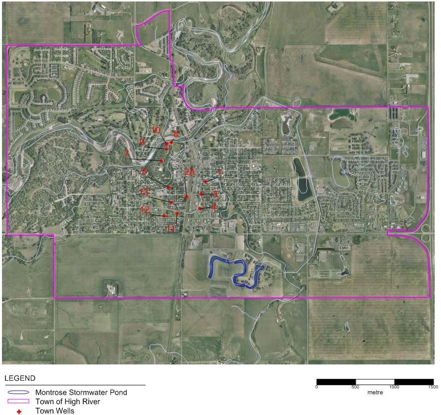
4 Site Location
5 Objectives Support a sustainable water management plan for the Town; Determine sustainable yield of the well field in the aquifers underlying and abutting the Town; Assessment of surface water/groundwater interactions from current and (proposed future) wells; Quantitatively predict/estimate effects of pumping by different sectors, under different climatic scenarios; Identify additional data needs.
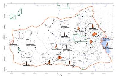
6 Data Sources 1,637 wells records selected from the well database (ESRD) Surficial and consolidated geological maps (AGS); Regional scale geological and hydrogeological studies (ARC); Hydrogeological investigation reports commissioned by the Town of High River; Base map (IHS Accumap 2011); Digital elevation model (CCG); Surface water monitoring (WSC); and Town well field operational data (Town of High River); 6

7 Hydrogeological Conceptual Model What is a hydrogeological conceptual model? Defines the structure of the system; Defines the hydraulic properties and flow mechanisms; Defines the water inputs and outputs; 7
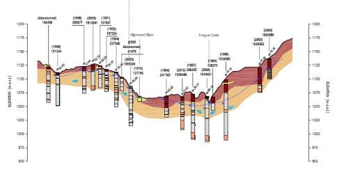
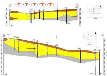
8 Hydrogeological Conceptual Model Hydrogeological Conceptual Model 8
9 Limitations and Assumptions Model provides a simplified representation of the real system Hydraulic parameters were averaged over zones of relatively uniform characteristics Quick recovery rates in pumping wells consistent with fairly direct hydraulic communication with the river 9
 stresses FEFLOW 6.")
10 Code Selection Three-Dimensional groundwater model Simulate flow & yield in main aquifers Predict effects of natural (climatic change) & artificial (pumping) stresses FEFLOW 6.0 Finite element flow and transport code (WASY, GmbH) Flexibility in gridding Groundwater density, and coupled solute transport and heat

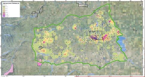
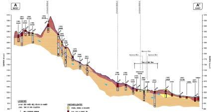
11 Model Structure Lithological Unit Aquifer/Aquitard Model Layer Surficial Deposit Aquitard 1 Model construction Model domain 840 km 2 ; Six layer model; Element size (horizontal) 30 m 2 to 0.1 km 2 ; and, Denser finite element mesh near town. Sand and Gravel Aquifer 2 and 3 Confining Unit 1 Aquitard 4 Confining Unit 2 Aquitard 5 Interbedded Sandstone Aquifer 6 Town of High River 11

12 Hydraulic Conductivity Distribution Sand and Gravel Aquifer 12
13 Boundary Conditions Sand and Gravel Aquifer 13
14 Model Calibration Steady State Calibration 39 groundwater levels in the sand and gravel aquifer, and 94 groundwater levels in the sandstone aquifer For pre-pumping conditions, oldest data used as calibration targets Regional Town 14
15 Model Calibration Steady State Calibration Regional hydraulic head distribution in the sand and gravel unit High River Hydraulic Head (masl) 15

16 Model Calibration Steady State Calibration Regional hydraulic head distribution in the sandstone aquifer High River Hydraulic Head (masl) 16


17 Model Calibration Transient Calibration Focus on representing aquifers response to pumping around Town Simulated vs. to observed responses in 12 town wells 17
18 Calibrated Hydraulic Parameters Hydraulic conductivity and recharge rate Lithological Unit Horizontal hydraulic conductivity [Kxy] (m/s) Vertical hydraulic conductivity [Kz] (m/s) Recharge (mm/y) Surficial Deposit (above sand and gravel) 1.0x10⁻⁶ to 1.5x x10-7 to 2.0x to 40 Surficial Deposit (clay and till) 1.0x x10-8 less than 1 Sand and Gravel 1.0x10⁻⁷ to 2.0x x10-7 to 2.0x Confining Unit 1 1.0x10⁻⁹ to 1.0x x10-10 to 1.0x Confining Unit 2 1.0x10⁻⁹ to 1.0x x10-10 to 1.0x Interbedded Sandstone 5.0x x Specific storage value of 1x10⁻⁴ m -1 and a effective porosity of 0.2 were assumed for the entire model domain. 18

19 Groundwater Drawdown End of / 2010 simulated groundwater drawdown in sand and gravel aquifer Simulated using operational data Groundwater drawdown is less than 3 m. End of

20 Contribution of Various Components Source of water withdrawn by Town wells Simulated for 2010 using operational data. 20
21 Scenarios Simulation period from 2010 to 2040 (30 years) Scenarios with various pumping rates and number of wells 12 well scenarios - Scenario 1 (4.9 Mm3/y) - Scenario 2 (7.2 Mm3/y) 15 well scenarios - Scenario 3 (4.9 Mm3/y) - Scenario 4 (7.2 Mm3/y) 21
22 River Contribution on Pumping Predicted river contribution with increased withdrawals Scenario 1 12 wells (4.9 Mm 3 /y) Scenario 2 12 wells (7.2 Mm 3 /y) Scenario 3 15 wells (4.9 Mm 3 /y) Scenario 4 15 wells (7.2 Mm 3 /y) Withdrawal 4.6 Mm 3 /year 4.9 Mm 3 /year 7.2 Mm 3 /year 4.9 Mm 3 /year 7.2 Mm 3 /year % GW originating from river % of minimum monthly river flow
23 Groundwater Drawdown (end of 2040) 12 well scenarios Scenario Scenario 2 23
24 Groundwater Drawdown (end of 2040) 15 well scenarios Scenario Scenario 4 24
25 Predictions Climate Change Shifts in Climate Simulated climate change scenarios indicate relatively low impact on the groundwater system if river flow is still maintained
26 Conclusions Current groundwater use no major impact on the groundwater system 70% of produced water originates from surface water With continuous pumping for next 30 years, river contribution over 80% Flow from the river to the aquifer equals 30% of monthly minimum river flow when pumping rate of 7.2 Mm 3 /y was simulated Climate change scenario* relatively low impact on the groundwater system * Assuming that river contribution to groundwater remains constant
27 27
Potential effects evaluation of dewatering an underground mine on surface water and groundwater located in a rural area
 Potential effects evaluation of dewatering an underground mine on surface water and groundwater located in a rural area ITRODUCTIO Michel Mailloux* Eng. M.Sc, Vincent Boisvert, M.Sc, Denis Millette, Eng.,
Groundwater Flow Model Development for Cumulative Effects Management within the Athabasca Oil Sands
 Groundwater Flow Model Development for Cumulative Effects Management within the Athabasca Oil Sands Margaret Scott, MASc, EIT Jos Beckers, PhD, P Geoph Matthew Webb, MSc Overview Groundwater Management
CHAPTER 7 GROUNDWATER FLOW MODELING
 148 CHAPTER 7 GROUNDWATER FLOW MODELING 7.1 GENERAL In reality, it is not possible to see into the sub-surface and observe the geological structure and the groundwater flow processes. It is for this reason
Simulation of horizontal well performance using Visual MODFLOW
 Environ Earth Sci (2013) 68:1119 1126 DOI 10.1007/s12665-012-1813-x ORIGINAL ARTICLE Simulation of horizontal well performance using Visual MODFLOW Wan Mohd Zamri W. Ismail Ismail Yusoff Bahaa-eldin E.
Dynamic groundwater-river interaction model for planning water allocation in a narrow valley aquifer system of the Upper Motueka catchment
 Dynamic groundwater-river interaction model for planning water allocation in a narrow valley aquifer system of the Upper Motueka catchment Timothy Hong t.hong@gns.cri.nz Gilles Minni g.minni@gns.cri.nz
Groundwater Modeling in Mining: A Case Study. FIDS Water Resources Symposium
 Groundwater Modeling in Mining: A Case Study Mundzir H. Basri London May 11-12, 2014 FIDS Water Resources Symposium Outline INTRODUCTION GUIDELINES AND OBJECTIVE MODEL CONSTRUCTION AND CALIBRATION SIMULATED
OUTLINE OF PRESENTATION
 GROUNDWATER?? OUTLINE OF PRESENTATION What is groundwater? Geologic investigation Definitions: aquifer and aquitard, unconfined and semi-confined Water level and interpretation of water level data Well
CHAPTER 2. Objectives of Groundwater Modelling
 CHAPTER 2 Objectives of Groundwater Modelling In the last two decades mathematical modelling techniques have increasingly proved their value in furthering the understanding of groundwater systems and,
BANAT PLAIN THE ROMANIAN CASE STUDY FREEWAT PLATFORM APPLICATION
 Open Workshop 1st FREEWAT User and Developers International Workshop September 21 st 2017 IDAEA. CID - CSIC 16 Jordi Girona. 08034 Barcelona BANAT PLAIN THE ROMANIAN CASE STUDY FREEWAT PLATFORM APPLICATION
3.2.3 Groundwater Simulation. (1) Purpose
 Purpose") The Study on Water Supply Systems in Mandalay City and in the Central Dry Zone Part II Study for Mandalay City 3.2.3 Groundwater Simulation (1) Purpose Because the Central Dry Zone, Myanmar, including
The Study on Water Supply Systems in Mandalay City and in the Central Dry Zone Part II Study for Mandalay City 3.2.3 Groundwater Simulation (1) Purpose Because the Central Dry Zone, Myanmar, including
The Cenomanian Sands aquifer model: an effective groundwater management tool
 The Cenomanian Sands aquifer model: an effective groundwater management tool Florence Lenhardt florence.lenhardt@sogreah.fr SOGREAH 6 rue de Lorraine 38130 Echirolles - France Noelle Doucet noelle.doucet@sogreah.fr
FAX
 21335 Signal Hill Plaza Suite 100 Sterling, Virginia 20164 www.geotransinc.com 703-444-7000 FAX 703-444-1685 Mr. William Kutash Florida Department of Environmental Protection Waste Management Division
4.4 MODEL CODE DESCRIPTION 4.5 WATER SOURCES AND SINKS 4.6 MODEL DOMAIN AND BOUNDARIES. SLR South Africa
 Page 4-18 The developed model should therefore be seen as an initial site model which should be refined and recalibrated once more groundwater monitoring and other data become available. 4.4 MODEL CODE
LAKE LABELLE DEWATERING MODEL. AUTHOR Gail Murray Doyle, P.G. September Murray Consultants, Inc 769 Skyview Dr Hayesville, NC
 LAKE LABELLE DEWATERING MODEL AUTHOR Gail Murray Doyle, P.G. September 2013 Murray Consultants, Inc 769 Skyview Dr Hayesville, NC 28904 828-389-2476 LAKE LABELLE DEWATERING MODEL INTRODUCTION Purpose The
Numerical Groundwater Model for the Kaweah Delta Water Conservation District
 Numerical Groundwater Model for the Kaweah Delta Water Conservation District Nels Ruud and Peter Leffler Fugro West, Inc. Larry Dotson Kaweah Delta Water Conservation District Presentation Outline Background
REPORT ON APPROACHES AND METHODS FOR EVALUATION VERTICAL TRANSPORT IN GROUNDWATER HYDROGEOLOGICAL ASSESSMENT TOOLS PROJECT.
 Ltd. 500 4260 Still Creek Drive Burnaby, British Columbia, Canada V5C 6C6 Telephone (604) 296-4200 Fax (604) 298-5253 REPORT ON APPROACHES AND METHODS FOR EVALUATION VERTICAL TRANSPORT IN GROUNDWATER HYDROGEOLOGICAL
MODELING INVESTIGATION ON THE SUSTAINABLE GROUNDWATER YIELD FOR WIANG PA PAO AQUIFERS SYSTEM
 MODELING INVESTIGATION ON THE SUSTAINABLE GROUNDWATER YIELD FOR WIANG PA PAO AQUIFERS SYSTEM Phatcharasak Arlai 1*, Manfred Koch 2, Sitisak Munyu 3, Kriangsak Pirarai 3 and Arun Lukjan 1 1 Research Unit
Daniel R. Hadley, PG and Daniel B. Abrams, PhD
 Revisiting one of the largest aquifer tests in history: Implications for fault zone hydrogeology and the declining groundwater supply in Northeastern Illinois Daniel R. Hadley, PG and Daniel B. Abrams,
Water supply issues in unconfined bedrock aquifers in the Ft. McMurray area
 Water supply issues in unconfined bedrock aquifers in the Ft. McMurray area Alex Haluszka, M.Sc., P.Geol., Hydrogeologist Chris Pooley, P.Geoph., Geophysicist Gordon MacMillan, P.Geol., Principal Hydrogeologist
Maintaining Ecohydrological Sustainability of Alberta s Urban Natural Areas Adjacent to Proposed Residential Developments
 Maintaining Ecohydrological Sustainability of Alberta s Urban Natural Areas Adjacent to Proposed Residential Developments Water Tech 2017, Banff, AB Urban Analysis, City Planning April 2017 Presented by
Questions: What is calibration? Why do we have to calibrate a groundwater model? How would you calibrate your groundwater model?
 Questions: What is calibration? Why do we have to calibrate a groundwater model? How would you calibrate your groundwater model? 13-11-2009 1 Uncertainties in groundwater models Conceptual model uncertainty
William Wilmot Matrix Solutions Inc. 118, Avenue S.W., Calgary, Alberta, Canada
 Hydrogeologic Assessment in Support of the Development of the Peace River Oil Sands Deposit: A Case Study Concerning a Pilot-Scale in-situ SAGD Operation William Wilmot Matrix Solutions Inc. 118, 319-2
Abstract. 1 Introduction
 Field simulation for land displacements by a three-dimensionalfiniteelement model H.D. Yeh," R.H. Lu/ G.T. Yeh' " Institute of Environmental Engineering; * Department of Civil Engineering, National Chiao-Tung
Groundwater Modeling Guidance
 Groundwater Modeling Guidance Richard J. Mandle Groundwater Modeling Program Michigan Department of Environmental Quality Draft 1.0 10/16/02 Executive Summary The use of groundwater models is prevalent
University of Arizona Department of Hydrology and Water Resources Dr. Marek Zreda. HWR431/531 - Hydrogeology Problem set #1 9 September 1998
 University of Arizona Department of Hydrology and Water Resources Dr. Marek Zreda HWR431/531 - Hydrogeology Problem set #1 9 September 1998 Problem 1. Read: Chapter 1 in Freeze & Cherry, 1979. McGuiness
Mitigation of Seawater Intrusion using Subsurface Intakes of Desalination Plants
 2016 AWRA Annual Conference 13 17 November 2016, Orlando Florida Mitigation of Seawater Intrusion using Subsurface Intakes of Desalination Plants Mohsen Sherif 1, Akbar Javadi 2, Ampar Shetty 1 1, UAE
Groundwater Modeling for. in the Upper Central Plain of Thailand
 Groundwater Modeling for Conjunctive Use Patterns Investigation in the Upper Central Plain of Thailand Colloque International Symposium May 31, 2006 Dijon, France Werapol Bejranonda Water Resources System
RESPONSIBLE PLANNING FOR FUTURE GROUND WATER USE FROM THE GREAT FLATS AQUIFER : TWO CASE STUDIES: THE GEP ENERGY
 RESPONSIBLE PLANNING FOR FUTURE GROUND WATER USE FROM THE GREAT FLATS AQUIFER : TWO CASE STUDIES: THE GEP ENERGY Introduction PROJECT AND THE SI GREEN FUELS BOILER PROJECT Thomas M. Johnson Hydrogeologist,
APPENDIX 5: SAMPLE MODEL RESULTS
 APPENDIX 5: SAMPLE MODEL RESULTS A. Evaluation of Groundwater Sustainability in the Ramsey Area B. Evaluation of Groundwater Sustainability in the Woodbury Area C. Evaluation of Future Drawdown Conditions
A MODEL OF SEAWATER INTRUSION IN SURFICIAL AND CONFINED AQUIFERS OF NORTHEAST FLORIDA
 The Second International Conference on Saltwater Intrusion and Coastal Aquifers - Monitoring, Modeling, and Management. Mérida, Yucatán, México, March 30 - April 2, 2003 A MODEL OF SEAWATER INTRUSION IN
Predicting Groundwater Sustainability: What Tools, Models and Data are Available?
 Predicting Groundwater Sustainability: What Tools, Models and Data are Available? Ray Wuolo Barr Engineering Company Assessing Sustainability is All About: Predicting (or describing) how potentiometric
K.Sangeetha, B.Narasimhan Department of Civil Engineering, Indian Institute of Technology, Madras
 Analytic Element Method (AEM) and its Relevance with Subbasin/HRU concept of SWAT for potential integration of AEM based simple ground water model K.Sangeetha, B.Narasimhan Department of Civil Engineering,
FIELD TESTING AQUIFERS TO. (Field Follies) James Robinson, Goodwyn, Mills and Cawood, Inc.
 James Robinson, Goodwyn, Mills and Cawood, Inc.") FIELD TESTING AQUIFERS TO ESTIMATE HYDRAULIC PROPERTIES (Field Follies) James Robinson, Goodwyn, Mills and Cawood, Inc. Objectives Estimate t hydraulic coefficients; i Test conceptual models of aquifer;
FIELD TESTING AQUIFERS TO ESTIMATE HYDRAULIC PROPERTIES (Field Follies) James Robinson, Goodwyn, Mills and Cawood, Inc. Objectives Estimate t hydraulic coefficients; i Test conceptual models of aquifer;
WELLHEAD PROTECTION DELINEATION REPORT FOR THE VILLAGE OF BEAR LAKE DECEMBER 2002
 WELLHEAD PROTECTION DELINEATION REPORT FOR THE VILLAGE OF BEAR LAKE DECEMBER 2002 Prepared by: Gosling Czubak Engineering Sciences, Inc. 1280 Business Park Drive Traverse City, Michigan 48686 Telephone:
Groundwater Models and Modeling Considerations
 Groundwater Models and Modeling Considerations MPCA Industrial Landfill Guidance Workgroup April 30, 2009 Terry Johnson, P.G. Waste Management Inc., The Three Legs of the Stool 1. Engineering design and
Fully Three dimensional Poroelastic Model
 Fully Three dimensional Poroelastic Model SimulatingReverse GroundwaterFluctuations During Aquifer Pumping David J. Hart, Wisconsin Geological and Natural History Survey Madison, WI Joshua S. Roberts,
CHRISTCHURCH CITY GROUNDWATER MODEL
 CHRISTCHURCH CITY GROUNDWATER MODEL Mike Thorley 1, Peter Callander 1, Howard Williams 1, Hilary Lough 1, Mike Kininmonth 2, Bruce Henderson 2 1 Pattle Delamore Partners Ltd Level 2, Radio New Zealand
INCORPORATION OF GROUNDWATER FLOW INTO NUMERICAL MODELS AND DESIGN MODELS
 INCORPORATION OF GROUNDWATER FLOW INTO NUMERICAL MODELS AND DESIGN MODELS Jeffrey D. Spitler, Ph.D., P.E., Simon J. Rees, Ph.D., and Andrew D. Chiasson Oklahoma State University School of Mechanical and
GROUNDWATER MODELING OF A PERMEABLE REACTIVE BARRIER TO ENHANCE SYSTEM PERFORMANCE
 GROUNDWATER MODELING OF A PERMEABLE REACTIVE BARRIER TO ENHANCE SYSTEM PERFORMANCE K.C. Scott, P.G., and D. J. Folkes, P.E. EnviroGroup Limited, 7208 South Tucson Way, Suite 125, Englewood, CO 80112; Phone:
Investigation of sustainable development potential for Ulubey Aquifer System, Turkey
 doi:10.5194/piahs-364-513-2014 Evolving Water Resources Systems: Understanding, Predicting and Managing Water Society Interactions Proceedings of ICWRS2014, Bologna, Italy, June 2014 (IAHS Publ. 364, 2014).
Context for Central Sands Water Use Trends and Impacts
 Context for Central Sands Water Use Trends and Impacts Wisconsin Food, Land, and Water meeting Wisconsin Rapids, WI November 10, 2016 Kenneth R. Bradbury Wisconsin Geological and Natural History Survey,
Figure 3: Refined Interpolated Groundwater Level Contours Based on Information from the MOE Water Well Information System (WWIS)
") Figure 3: Refined Interpolated Groundwater Level Contours Based on Information from the MOE Water Well Information System (WWIS) Figure 4: Strahler Classes 1 through 4 Defined as Drains and Rivers Figure
Figure 3: Refined Interpolated Groundwater Level Contours Based on Information from the MOE Water Well Information System (WWIS) Figure 4: Strahler Classes 1 through 4 Defined as Drains and Rivers Figure
Municipal Groundwater Flow Modelling Study. Town of Torbay, NL
 Municipal Groundwater Flow Modelling Study Town of Torbay, NL October 19, 2015 Agenda 1 Purpose 2 What is a Groundwater Model 3 Approach 4 Conceptual Model & GW Flow Model Construction 5 Model Predictions
Numerical Modeling of Groundwater Flow in the Navajo Sandstone Aquifer at the Tuba City, Arizona, Disposal Site 15167
 Numerical Modeling of Groundwater Flow in the Navajo Sandstone Aquifer at the Tuba City, Arizona, Disposal Site 15167 ABSTRACT Richard Bush*, Timothy Bartlett** *US DOE, Office of Legacy Management **Stoller
Numerical Groundwater Flow Model Report. Caloosa Materials, LLC 3323 Gulf City Road Ruskin, Florida 33570
 Numerical Groundwater Flow Model Report Caloosa Materials, LLC 3323 Gulf City Road Ruskin, Florida 33570 GHD 2675 Winkler Ave Suite 180 Fort Myers, FL 33901 11138224 Report July 27, 2017 Table of Contents
Evaluating Impoundment Closure Scenarios using Fate and Transport Modeling
 2017 World of Coal Ash (WOCA) Conference in Lexington, KY - May 9-11, 2017 http://www.flyash.info/ Evaluating Impoundment Closure Scenarios using Fate and Transport Modeling Jacob J. Walczak 1, Meng Wang
DEVELOPMENT OF AQUIFER TESTING PLANS. Brent Bauman, P.G. / Erin Lynam, Aquatic Biologist
 DEVELOPMENT OF AQUIFER TESTING PLANS Brent Bauman, P.G. / Erin Lynam, Aquatic Biologist DEVELOPMENT OF AQUIFER TESTING PLANS Goals of Aquifer Testing What questions are we trying to answer Staff review
NUMERICAL MODELING TO INVESTIGATE SAFE YIELD IN MAE SAI MULTILAYERED AQUIFERS
 NUMERICAL MODELING TO INVESTIGATE SAFE YIELD IN MAE SAI MULTILAYERED AQUIFERS Phatcharasak Arlai 1*, Sitisak Munyu 2, Kriangsak Pirarai 2 and Arun Lukjan 1 1 International Program of M.Eng in Water Resources
Groundwater Occurrence & Movement:
 Groundwater Occurrence & Movement: An Introductory Discussion with Application to East-Central Illinois East-Central Illinois Regional Water Supply Planning Committee July 27, 2007 Allen Wehrmann, P.E.,
Pore-Water Pressure Definition for a Levee Stability Analysis
 Pore-Water Pressure Definition for a Levee Stability Analysis GEO-SLOPE International Ltd. www.geo-slope.com 1200, 700-6th Ave SW, Calgary, AB, Canada T2P 0T8 Main: +1 403 269 2002 Fax: +1 888 463 2239
Numerical Simulation of Basal Aquifer Depressurization in the Presence of Dissolved Gas
 Numerical Simulation of Basal Aquifer Depressurization in the Presence of Dissolved Gas Karl P. Lawrence, Ph.D. Rock Engineering Division Golder Associates Mississauga, Ontario, Canada Outline Motivation:
ENGINEERING HYDROLOGY
 ENGINEERING HYDROLOGY Prof. Rajesh Bhagat Asst. Professor Civil Engineering Department Yeshwantrao Chavan College Of Engineering Nagpur B. E. (Civil Engg.) M. Tech. (Enviro. Engg.) GCOE, Amravati VNIT,
Report on Effects of Groundwater Withdrawal from the Doghouse Meadow, Yosemite National Park
 Report on Effects of Groundwater Withdrawal from the Doghouse Meadow, Yosemite National Park William E. Sanford Department of Geosciences Colorado State University 03 March 2006 1 Purpose The purpose of
DYNFLOW accepts various types of boundary conditions on the groundwater flow system including:
 Section 6 Groundwater Flow Model A groundwater flow model was developed to evaluate groundwater flow patterns in the site area and to provide a basis for contaminant transport modeling. 6.1 Model Code
Introduction. In-situ Steam Assisted Gravity Drainage (SAGD) oil sand operations require a source of fresh water for steam injection.
 oil sand operations require a source of fresh water for steam injection.") Assessing Cumulative Effects of SAGD Operations in the Mackay Watershed Dirk Kassenaar, Earthfx Inc. Watertech 2016 April 7, 2015 Introduction In-situ Steam Assisted Gravity Drainage (SAGD) oil sand operations
Assessing Cumulative Effects of SAGD Operations in the Mackay Watershed Dirk Kassenaar, Earthfx Inc. Watertech 2016 April 7, 2015 Introduction In-situ Steam Assisted Gravity Drainage (SAGD) oil sand operations
Strategies for Managing Water Resources in Saltwater Intrusion Environments
 Hilton Head Public Service District Groundwater Management Associates, Inc. Strategies for Managing Water Resources in Saltwater Intrusion Environments Hilton Head Island and Vicinity Feet Below Mean Sea
Groundwater basics. Groundwater and surface water: a single resource. Pore Spaces. Simplified View
 Groundwater and surface water: a single resource Santa Cruz River, Tucson Groundwater basics Groundwater is water found within the pore spaces of geologic material beneath the surface of the Earth. It
Irrigation modeling in Prairie Ronde Township, Kalamazoo County. SW Michigan Water Resources Council meeting May 15, 2012
 Irrigation modeling in Prairie Ronde Township, Kalamazoo County SW Michigan Water Resources Council meeting May 15, 2012 Development of a Groundwater Flow Model INFLOWS Areal recharge from precipitation
MODELLING THE GROUNDWATER FLOW FOR ESTIMATING THE PUMPING COST OF IRRIGATION IN THE AQUIFER OF N. MOUDANIA, GREECE
 Proceedings of the 13 th International Conference on Environmental Science and Technology Athens, Greece, 5-7 September 2013 MODELLING THE GROUNDWATER FLOW FOR ESTIMATING THE PUMPING COST OF IRRIGATION
APPENDIX A HYDROLOGIC EVALUATION OF LANDFILL PERFORMANCE (HELP) MODEL RESULTS (20)
 MODEL RESULTS (20)") APPENDIX A HYDROLOGIC EVALUATION OF LANDFILL PERFORMANCE (HELP) MODEL RESULTS 044985 (20) 44985-5m CLAY COVER ASSESSMENT.txt ******************************************************************************
APPENDIX A HYDROLOGIC EVALUATION OF LANDFILL PERFORMANCE (HELP) MODEL RESULTS 044985 (20) 44985-5m CLAY COVER ASSESSMENT.txt ******************************************************************************
Memorandum. Introduction. Carl Einberger Joe Morrice. Figures 1 through 7
 Memorandum TO: Michelle Halley, NWF DATE: October 9, 2007 FROM: Carl Einberger Joe Morrice PROJ. NO.: 9885.000 CC: Project File PROJ. NAME: National Wildlife Federation ATTACHMENTS: Tables 1 through 6
ENG. MUSLEM B. KASHOB MINISTRY OF REGIONAL MUNICIPALITY AND WATER RESOURCES DEPARTMENT OF MATHEMATICAL MODELING MUSCAT, OMAN
 Put your Organizati on logo here ENG. MUSLEM B. KASHOB MINISTRY OF REGIONAL MUNICIPALITY AND WATER RESOURCES DEPARTMENT OF MATHEMATICAL MODELING MUSCAT, OMAN Overview Introduction Objectives Study area
Modelling Possible Structural Instabilities Of The Po River Embankment, Italy, Due To Groundwater Pumping In The Ferrara Province
 Modelling Possible Structural Instabilities Of The Po River Embankment, Italy, Due To Groundwater Pumping In The Ferrara Province M. Ferronato 1, G. Gambolati 1, P. Teatini 1, M. Gonella 2, C. Bariani
Hydraulic Head in 1999 Saline plume migration in 1999
 Numerical Modeling of possible Saltwater Intrusion Mechanisms in the Multiple Layer Coastal Aquifer System of the Gulf of Thailand by Mr.Phatcharasak Arlai Contents of Presentation 1. Introduction 2. Literature
Groundwater and surface water: a single resource. Santa Cruz River, Tucson
 Groundwater and surface water: a single resource Santa Cruz River, Tucson 1942 1989 1 Groundwater basics Groundwater is water found within the pore spaces of geologic material beneath the surface of the
Genetic Algorithm based Simulation Optimization Approach to Seawater Intrusion
 International Symposium on Genetic Algorithm based Simulation Optimization Approach to Seawater Intrusion 1313 Integrated Water Resources Management (IWRM 2014) February 19 21, 2014, CWRDM, Kozhikode,
Science Olympiad. Mentor Invitational Hydrogeology ANSWER KEY. Name(s): School Name: Point Totals
: School Name: Point Totals") Science Olympiad Mentor Invitational Hydrogeology ANSWER KEY Team Number: Raw Score: Rank: Name(s): School Name: Point Totals Possible Part 1: Groundwater Concepts and Vocabulary 30 Part 2: The Hydrogeology
Science Olympiad Mentor Invitational Hydrogeology ANSWER KEY Team Number: Raw Score: Rank: Name(s): School Name: Point Totals Possible Part 1: Groundwater Concepts and Vocabulary 30 Part 2: The Hydrogeology
UK Technical Advisory Group on the Water Framework Directive
 UK Technical Advisory Group on the Water Framework Directive Defining & Reporting on Groundwater Bodies This Guidance Paper is a working draft defined by the UKTAG. It documents the principles to be adopted
Manfred KOCH 1 and Phatsaratsak ARLAI 1, Department of Geotechnology and Engineering Hydrology, University of Kassel, Germany
 Deterministic and stochastic modeling of groundwater flow and solute transport in the heavily-stressed Bangkok coastal aquifer, Thailand, and investigation of optimal management strategies for possible
Numerical Simulation and Prediction of Groundwater Flow in a Coastal Aquifer of Southern India
 Journal of Water Resource and Protection, 2015, 7, 1483-1494 Published Online December 2015 in SciRes. http://www.scirp.org/journal/jwarp http://dx.doi.org/10.4236/jwarp.2015.717122 Numerical Simulation
Simulation of Sub-Drains Performance Using Visual MODFLOW for Slope Water Seepage Problem
 IOP Conference Series: Materials Science and Engineering PAPER OPEN ACCESS Simulation of Sub-Drains Performance Using Visual MODFLOW for Slope Water Seepage Problem To cite this article: M F T Baharuddin
T E C H N I C A L M E M O R A N D U M
 INTERA Incorporated 9600 Great Hills Trail, Suite 300W Austin, Texas, USA 78759 512.425.2000 T E C H N I C A L M E M O R A N D U M To: From: Barton Springs/Edwards Aquifer Conservation District Wade Oliver,
6. Hydrogeological zones and groundwater resources balance baseflow map of the Czech Republic. Jiri Sima
 6. Hydrogeological zones and groundwater resources balance baseflow map of the Czech Republic Jiri Sima General content Regional hydrogeological units Groundwater resources assessment Water balancing background
Numerical Modeling of Groundwater Flow in Karst Aquifer, Makeng Mining Area
 American Journal of Environmental Sciences 6 (1): 78-82, 2010 ISSN 1553-345X 2010 Science Publications Numerical Modeling of Groundwater Flow in Karst Aquifer, Makeng Mining Area 1,2 F.M. Rani and 1 Z.H.
Purpose. Utilize groundwater modeling software to forecast the pumping drawdown in a regional aquifer for public drinking water supply
 MODFLOW Lab 19: Application of a Groundwater Flow Model to a Water Supply Problem An Introduction to MODFLOW and SURFER The problem posed in this lab was reported in Chapter 19 of "A Manual of Instructional
Documentation of Groundwater Agent-based Model
 Documentation of Groundwater Agent-based Model Comments or suggestions to 1. Introduction In environmental resources management there is the recognition of need for combined socio-environmental
Name: Problem 1. (30 points; 5 each)
") 2700 2500 1900 2100 1500 2300 1800 1700 Hydrogeology - HWR/GEOS 431/531 Final exam Dr. Marek Zreda 16 December 1998 11:00-1:00 Open books and notes There are 5 problems on 7 pages. Read entire test before
2700 2500 1900 2100 1500 2300 1800 1700 Hydrogeology - HWR/GEOS 431/531 Final exam Dr. Marek Zreda 16 December 1998 11:00-1:00 Open books and notes There are 5 problems on 7 pages. Read entire test before
AQUA th September 2015, ROME
 AQUA 2015 15 th September 2015, ROME Low velocity areas' influence on contaminant persistence: a field study (Milan, Italy) Alberti Luca 1, Colombo Loris 1, Francani Vincenzo 1 1 Politecnico di Milano,
USGS Groundwater Resources Program Regional Groundwater Evaluations
 USGS Groundwater Resources Program Regional Groundwater Evaluations -- Northern Atlantic Coastal Plain Aquifer System -- John Masterson* New England Water Science Center Northborough, Massachusetts Delaware
4. Groundwater Resources
 4. Groundwater Resources 4-1 Majority (97 %) of unfrozen fresh water on earth exists as groundwater. In comparison to surface water, - groundwater is available all year around - groundwater is mostly invisible
GROUNDWATER Dr. DEEPAK KHARE GENERAL HYDROLOGY CYCLE FORMATIONS
 GROUNDWATER By Dr. DEEPAK KHARE Associate Professor Department of Water Resources Development & Management Indian Institute of Technology Roorkee, ROORKEE (Uttaranchal) 247 667, India E-mail: kharefwt@iitr.ernet.in
Environmental Data Management and Modeling, Niagara Falls Storage Site Lewiston, New York
 Environmental Data Management and Modeling, Niagara Falls Storage Site Lewiston, New York Eric Evans and Don DeMarco HydroGeoLogic, Inc. May 7, 2008 Mr. Eric Evans, M.Sc., P.G. is a Senior Hydrogeologist
Feasibility Study of Artificial Aquifer Recharge in the Walla Walla Basin. Presenter: Arístides Petrides
 Feasibility Study of Artificial Aquifer Recharge in the Walla Walla Basin Presenter: Arístides Petrides Overview of Presentation Background Walla Walla River Basin Previous Modeling Effort with IWFM New
Surface Water and Seawater Interactions in the Coastal Environment of Biscayne Bay, Southeast Florida
 Surface Water and Seawater Interactions in the Coastal Environment of Biscayne Bay, Southeast Florida William C. Hutchings, MS, PG Nicholas Albergo, PE, DEE Paper No. 191-8 2005 Salt Lake City Annual Meeting
Investigation of a Floodplain Pond to Improve Alluvial Aquifer Sustainability: A Quantity and Quality Report
 Investigation of a Floodplain Pond to Improve Alluvial Aquifer Sustainability: A Quantity and Quality Report Water Resources Investigation Report 16 i P a g e Investigation of a Floodplain Pond to Improve
Groundwater Lowering in Multi-layer Aquifer Systems: Case Study of Esna City Egypt Abstract 1. Introduction
 1. 2. 3. Groundwater Lowering in Multi-layer Aquifer Systems: Case Study of Esna City Egypt Ashraf H.M. Ghanem 1, Ashraf S. Zaghloul 2, and Soha El-Ayouti 3 Professor, Irrigation and Hydraulics Department,
MEMORANDUM. RAI Responses Related to East Lake Road Wellfield Drawdown Analysis, WUP No SDI Project No. PCF-180.
 SDI Environmental Services, Inc. 13911 N. Dale Mabry Hwy. Suite 201, Tampa, FL 33618; (813) 961-1935 MEMORANDUM TO: FROM: SUBJECT: Dave Slonena, P.G., Pinellas County Cathleen Beaudoin Jonas RAI Responses
Groundwater Occurrence & Movement: An Introductory Discussion with Application to Northeastern Illinois
 Groundwater Occurrence & Movement: An Introductory Discussion with Application to Northeastern Illinois H. Allen Wehrmann, P.E., Director Center for Groundwater Science Illinois State Water Survey April
The Hydrogeology Challenge: Water for the World TEACHER S GUIDE
 The Hydrogeology Challenge: Water for the World TEACHER S GUIDE Why is learning about groundwater important? 95% of the water used in the United States comes from groundwater. About half of the people
Hydrogeology 101 3/7/2011
 Hydrogeology 101 W. Richard Laton, Ph.D., PG, CPG Associate Professor of Hydrogeology California State University, Fullerton Department of Geological Sciences 1 Hydrogeology 101 The objective is to obtain
Centre Wellington Scoped Tier Three Water Budget Assessment
 Centre Wellington Scoped Tier Three Water Budget Assessment Community Liaison Group Meeting #3 Aboyne Hall, Wellington County Museum Tuesday, May 15, 2018, 7:00 9:30 pm 1 MEETING PURPOSE Provide a refresh
Information Request 11
 Information Request 11 Information Request 11 11-1 Responses to Information Request 11 Response to Information Request 11a Response to Information Request 11b 11-2 11-6 Federal Review Panel Information
Characterizing Groundwater and Surface- Water Interactions in Selected Northeast Twin Cities Lakes
 Characterizing Groundwater and Surface- Water Interactions in Selected Northeast Twin Cities Lakes Chapter A: Statistical Analysis and Field Study Chapter B: Groundwater-Flow Simulation Perry M. Jones,
Groundwater. Groundwater Movement. Groundwater Movement Recharge: the infiltration of water into any subsurface formation.
 On March 22, 2014, a major landslide occurred near Oso, Washington. Death toll currently at 30, with 15 still missing. Groundwater Before and After Swipe http://bit.ly/pen1jt N. Fork Stillaguamish River
 5. MODEL DESCRIPTION Several models were used in combination to estimate the impacts of the proposed 100,000 acre-ft dryyear yield program. MODFLOW and MODPATH were used to estimate the groundwater and
NUMERICAL MODELLING OF SALTWATER PLUME MOVEMENT IN A FRACTURED AQUIFER ON SUB-REGIONAL SCALE
 NUMERICAL MODELLING OF SALTWATER PLUME MOVEMENT IN A FRACTURED AQUIFER ON SUB-REGIONAL SCALE Sascha E. Oswald (Groundwater Protection and Restoration Group, University of Sheffield, United Kingdom) INTRODUCTION
Modeling the Contamination of an Aquifer from a Highway Salt Storage Facility
 First International Conference on Saltwater Intrusion and Coastal Aquifers Monitoring, Modeling, and Management. Essaouira, Morocco, April 23 25, 01 Modeling the Contamination of an Aquifer from a Highway
Design of a passive hydraulic containment system using FEFLOW modelling
 Design of a passive hydraulic containment system using FEFLOW modelling Rémi Vigouroux remi.vigouroux@arteliagroup.com Florence Lenhardt florence.lenhardt@arteliagroup.com Noëlle Doucet noelle.doucet@arteliagroup.com
Grounding Water: An Exploration of the Unseen World Beneath Our Feet
 1 Grounding Water: An Exploration of the Unseen World Beneath Our Feet Kerry Schwartz, Director, Arizona Project WET Protect Your Groundwater Day: Tuesday, September 9, 2014 What I Hope to Convey Groundwater
STRAWMAN OUTLINE March 21, 2008 ISWS/ISGS REPORT ON THE OPPORTUNITIES AND CHALLENGES OF MEETING WATER DEMAND IN NORTH-EAST ILLINOIS
 STRAWMAN OUTLINE March 21, 2008 ISWS/ISGS REPORT ON THE OPPORTUNITIES AND CHALLENGES OF MEETING WATER DEMAND IN NORTH-EAST ILLINOIS REPORT TO BE DELIVERED TO THE RWSPG BY SEPTEMBER 30, 2008 Table of Contents