A decision support system for water quality in the Wadden Sea
|
|
|
- Jonathan Paul
- 5 years ago
- Views:
Transcription

1 47th Liege Colloquium Luigi Ceccaroni, Meinte Blaas, Marcel R. Wernand, Filip Velickovski, Anouk Blauw and Laia Subirats Liège, May 8 th 2015 A decision support system for water quality in the Wadden Sea
2 Index INDEX 1.- Optical monitoring in a citizen-science context 1. Item Optical properties and marine-environment status 2. Item Decision support system 3. Item Target users and applications 4. Item Conclusions 2
3 Index Optical monitoring in a citizen-science context 1. Item 1 Combination of data collected by: 2. Item 2 3. Item 3 4. Item 4 a distributed group of people (Citclops crowdsourcing) publicly available data: government satellites research-institutes campaigns Interpretation by context-aware artificialintelligence techniques 3
4 Index Optical properties and marine-environment status 1. Item 1 Optical properties as proxies of: 2. Item 2 3. Item 3 4. Item 4 sewage impact dissolved organic matter sediment load natural pigmentation And more generally: marine-environment status anthropogenic pressures on resources natural causes of abnormal conditions 4
5 Index Focus on color (FU) 1. Item 1 Dependent mostly on the optically active 2. Item 2 3. Item 3 4. Item 4 substances: SPM, algae, CDOM (and POC, TOC) Related to light extinction (Kd) and Secchi depth (SD), also dependent on the same substances Presence of the optically active substances steered by: currents, waves, wind, insolation, temperature, nutrients (TotN, TotP. PO4, NO3, NO3NO2, NH4, SiO2) Salinity as a proxy for river water, which carries most (not all) nutrients into the sea 5
")
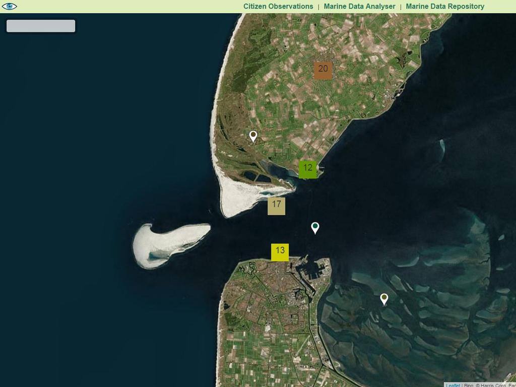
6 Study area in the Wadden Sea over a fixed study period ( ) 6
7 Index General objectives 1. Item 1 Assess and use available marine data: FU color 2. Item 2 3. Item 3 4. Item 4 index, suspended particulate matter, TSM, dissolved organic carbon, light extinction, Secchi disk depth, chlorophyll-a, waves height, river input, weather Learn a model of the target variable FU color at future points (2 days, 4 days, 7 days) Evaluate model s prediction of FU using 10-fold cross-validation Integrate model into Citclops Data Explorer Marine Data Analyser 7
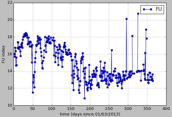
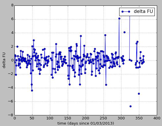
8 Index Available data sources 1. Item 1 In-situ: SPM, chlorophyll-a, DOC, Kd ( ) 2. Item 2 3. Item 3 4. Item 4 average time resolution: 2 data points per month (Deltares) In-situ: River input (1 data point per day), waves height (1 data point per hour) (Deltares) Satellite: MERIS instrument: FU, chlorophyll-a ( ) - time resolution: daily (missing data on cloudy days) In-situ: TSM, FU, chlorophyll-a ( ) - time resolution: every 2 min during daylight (some missing periods) (NIOZ) 8

9 Jetty Data - Daily means Mar 2013 Sep 2013 Oct 2014 Feb
10 Machine-learning pipeline Extract data from source Convert to data array Parsing Feature preparation Convert data into feature vectors + target value Select feature variables, amount of past time points Feature Selection Model selection Train and test a set of models (decision trees, SVM, Bayesian) Evaluate best model on unseen test set Final evaluation 10
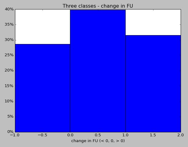
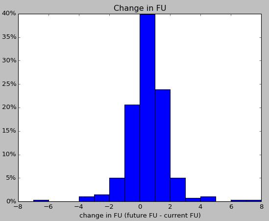
11 Converting to three class classification problem 11

12 Using mean daily values (example: TSM) 30 th Apr 6 th May 12 th May 18 th May 24 th May
13 Using mean daily values, sometimes few data points (example: TSM) 14 th Dec 18 th Dec 22 nd Dec 26 th Dec
 with a period of 12:25 h) 28 th Sep 1 st Oct 4 th Oct")
14 Short-term correlation to tide (Dominant semi-diurnal lunar tidal component (M2) with a period of 12:25 h) 28 th Sep 1 st Oct 4 th Oct
15
16 Index Knowledge coming from pre-processing 1. Item 1 Clear relation among color, tides, and other drivers: 2. Item 2 3. Item 3 4. Item 4 wind (which steers both waves and currents), river/sluice discharge and biology Short-term forecasting (within a tidal period): not possible without de-tiding the signals Longer-term forecasting: possibly improved by detiding the signals 16
17 Feature vector at time t Training data Time (days) t TSM Chl-a FU FU t+2 (target) FU t FU t-1 Feature and targetvariable preparation Chl t Chl t-1 TSM t 17
18 Index Highly flexible system with real-time processing 1. Item 1 Data set 2. Item 2 Feature configuration 3. Item 3 Machine-learning technique 4. Item 4 Temporal range of prediction Experiments and examples of results 18
19 Wave height TSM Chl-a Feature configuration ML technique Support Vector Machine C (soft-margin) : 1.0 Kernel : radial basis FU Number of examples for training 415 Blind predictor benchmark 48% Distribution of target FU classes decrease stable increase 27% 48% 25% Accuracy (10-fold cross- validation) 53% 19

 35 %")
20 Wave height Feature configuration ML technique TSM Chl-a Random Forest n_trees: 10 FU Number of examples for training 359 Blind predictor benchmark 35% Distribution of target FU classes decrease stable 33 % 32 % increase Accuracy (10-fold cross- validation) 35 % 52 % 20
21 Wave height TSM Chl-a FU Feature configuration ML technique Decision Tree max depth: 10 Number of examples for training 345 Blind predictor benchmark 35% Distribution of target FU classes decrease stable 34 % 31 % increase Accuracy (10-fold cross- validation) 35 % 45 % 21
22 Index Target users and applications 1. Item 1 Data from citizens, marine scientists and coastal 2. Item 2 3. Item 3 4. Item 4 planners to citizens and policy makers Plenty of potential applications: to simulate environmental crises to chart emergency-management plans of the coastal zone to provide sea farmers with bulletins about algal blooms to maximize citizens experience in activities in which water quality has a role to provide citizens with powerful, userfriendly tools of environment interpretation 22
23 Index Conclusions and future work 1. Item 1 First steps in real-time prediction of water color 2. Item 2 3. Item 3 4. Item 4 using easily-available data sources as context Transition towards a citizen-science scenario Use of citizen data to complement remotesensing and official in-situ data Use of machine-learning techniques in a very flexible framework Short-term impact on policy decision via decision support system 23
24 24
25 25
")


26 First stage: (Handcraft) Third stage, unit II (Prototype II, 3D print external LEDs) Second stage, unit I (Prototype I, 3D print, internal LED) 26

27 Slide 27 27

28 Slide 28 28

29 47th Liege Colloquium Luigi Ceccaroni, Barcelona Digital Technology Centre, Spain; Labs, Spain Meinte Blaas, Deltares, The Netherlands Marcel R. Wernand, Royal Netherlands Institute for Sea Research, The Netherlands Filip Velickovski, Barcelona Digital Technology Centre, Spain Anouk Blauw, Deltares, The Netherlands Laia Subirats, Barcelona Digital Technology Centre, Spain Liège, May 8 th 2015
Zu-Tao Ou-Yang Center for Global Change and Earth Observation Michigan State University
 Zu-Tao Ou-Yang Center for Global Change and Earth Observation Michigan State University Ocean Color: Spectral Visible Radiometry Color of the ocean contains latent information on the water qualitycdom,
Airborne Hyperspectral Potential for Coastal Biogeochemistry of the Scheldt Estuary and Plume
 Airborne Hyperspectral Potential for Coastal Biogeochemistry of the Scheldt Estuary and Plume M. Shimoni & M. Acheroy Signal and Image Centre, Royal Military Academy; D. Sirjacobs & S. Djenidi GeoHydrodynamic
Estimation of chlorophyll-a concentration in estuarine waters:
 Estimation of chlorophyll-a concentration in estuarine waters: case study of the Pearl River estuary Yuanzhi Zhang *, Chuqun Chen #, Hongsheng Zhang *, Xiaofei*, Chen Guiying Chen# *Institute of Space
Nutrient Response to Sewage Abatement in Hong Kong
 Nutrient Response to Sewage Abatement in Hong Kong Prof. Paul J. Harrison Atmospheric, Marine & Coastal Environment Program Institute for the Environment HK University of Science & Technology Outline Background
 Fernando Gilbes 1, William Hernández, Natlee Hernández, José Martínez, and Vilmaliz Rodriguez Geological and Environmental Remote Sensing Lab Department of Geology University of Puerto Rico at Mayagüez
Ocean Diurnal Variations Measured by the Korean Geostationary Ocean Color Imager
 Ocean Diurnal Variations Measured by the Korean Geostationary Ocean Color Imager Menghua Wang 1, Lide Jiang 1,2, Seunghyun Son 1,2, & Wei Shi 1,2 1 NOAA/NESDIS Center for Satellite Applications & Research
CS229 Project: Identifying Regions of High Turbidity in San Francisco Bay
 CS229 Project: Identifying Regions of High Turbidity in San Francisco Bay Joe Adelson December 11, 2014 Introduction Suspended sediments in oceans, seas, and estuaries shape coastal geography, provide
SPACE ASSISTED WATER QUALITY FORECASTING PLATFORM
 SPACE-O WORKSHOP ON USING WATER QUALITY FORECASTING INDECISION MAKING SPACE ASSISTED WATER QUALITY FORECASTING PLATFORM FOR OPTIMIZED DECISION MAKING IN WATER SUPPLY SERVICES TZIMAS APOSTOLOS PROJECT COORDINATOR
Great Lakes Remote Sensing Algorithms
 Great Lakes Remote Sensing Algorithms Status, Comparisons, and Future Directions Robert Shuchman MTRI Mike Sayers MTRI George Leshkevich NOAA/GLERL Barry Lesht JGLR/Assoc. Editor Caren Binding Environment
Satellite based inland and coastal water quality monitoring
 Satellite based inland and coastal water quality monitoring Harmonized transnational, long-term and near-real time space based solutions. Thomas Heege CEO EOMAP Germany Earth Observation & Mapping Inland
Joint Cruise Methodology
 Joint Cruise Methodology Alexander Mikaelyan & Tamara Shiganova Batumi, 22 May The main goal of the Joint Cruises To provide ecosystem monitoring of the open waters of the Black Sea on inter-annual and
Mathematical models in predicting the fate of Lake Pyhäjärvi waters
 Mathematical models in predicting the fate of Lake Pyhäjärvi waters Pori 22.10.2014 Timo Huttula, Inese Huttunen, Olli Malve, Anita Pätynen and Janne Ropponen SYKE Recent projects and modelling (besides
Satellite Monitoring of Water Quality in Lake Manzalah, Egypt. Real-Time Water Quality Monitoring Workshop June St.
 Satellite Monitoring of Water Quality in Lake Manzalah, Egypt Real-Time Water Quality Monitoring Workshop June 16-17 2009 St. John s, Canada Motivation Lakes are vital component of Egypt s water resources
Drones: A New Tool for Water Monitoring
 Drones: A New Tool for Water Monitoring Donglai Gong Carl Friedrichs, Ryan Carnegie Outline What are the goals of water monitoring (from marine scientist s perspective)? Healthy ecosystem? Fisheries /
Chromophoric Dissolved Organic Matter (CDOM) in United States Estuaries. Robert F. Chen, Bernie Gardner, Wei Huang & Francesco Peri
 in United States Estuaries. Robert F. Chen, Bernie Gardner, Wei Huang & Francesco Peri") Chromophoric Dissolved Organic Matter (CDOM) in United States Estuaries Robert F. Chen, Bernie Gardner, Wei Huang & Francesco Peri CDOM in Coastal Waters Chromophoric Dissolved Organic Matter (CDOM) Absorbs
Chromophoric Dissolved Organic Matter (CDOM) in United States Estuaries Robert F. Chen, Bernie Gardner, Wei Huang & Francesco Peri CDOM in Coastal Waters Chromophoric Dissolved Organic Matter (CDOM) Absorbs
Long-Term Volunteer Lake Monitoring in the Upper Woonasquatucket Watershed
 Long-Term Volunteer Lake Monitoring in the Upper Woonasquatucket Watershed Linda Green URI Watershed Watch 1-87-95, lgreen@uri.edu WATER QUALITY IS A REFLECTION OF THE ACTIVITIES IN THE LANDS AND WATERS
Current and estimated future atmospheric nitrogen loads to the Chesapeake Bay Watershed
 Current and estimated future atmospheric nitrogen loads to the Chesapeake Bay Watershed Jesse O. Bash, Kyle Hinson, Patrick Campbell, Norm Possiel, Tanya Spero, Chris Nolte 1 Outline Background of historic
Captiva Water Quality Assessment Project Update Supported by TDC s Beach & Shoreline Program through the Captiva Community Panel
 Captiva Water Quality Assessment Project Update Supported by TDC s Beach & Shoreline Program through the Captiva Community Panel Mark Thompson & Loren Coen Marine Laboratory, Sanibel-Captiva Conservation
Development of Carbon Data Products for the Coastal Ocean: Implications for Advanced Ocean Color Sensors
 Development of Carbon Data Products for the Coastal Ocean: Implications for Advanced Ocean Color Sensors Antonio Mannino NASA Goddard Space Flight Center Greenbelt, Maryland USA Field Activities & DOC
Status of FerryBox Systems in Europe. Franciscus Colijn and Wilhelm Petersen HZG
 Status of FerryBox Systems in Europe Franciscus Colijn and Wilhelm Petersen HZG History of using Ships of Opportunity (SoOs) for Ocean Monitoring 1853 Brussels Conference: systemizing reporting of marine
METODOLOGIE E APPROCCI PER OSSERVAZIONI IPERSPETTRALI IN ACQUE COSTIERE E INTERNE
 Data Exploitation della missione PRISMA, precursore delle missioni iperspettrali nazionali Roma, 1-3 marzo 2017 METODOLOGIE E APPROCCI PER OSSERVAZIONI IPERSPETTRALI IN ACQUE COSTIERE E INTERNE Federica
Hobcaw Barony and the USC Baruch Marine Field Laboratory
 Hobcaw Barony and the USC Baruch Marine Field Laboratory James L. Pinckney Marine Science Program and Department of Biological Sciences School of the Earth, Ocean, and Environment University of South Carolina
Chemical and Physical Analysis of the Cape Fear Estuary
 The Cape Fear River Chemical and Physical Analysis of the Cape Fear Estuary The Cape Fear River (CFR), the most industrialized of all North Carolina s rivers, winds for over miles through the heart of
Feedback mechanisms between cyanobacterial blooms, transient hypoxia and benthic phosphorus regeneration in shallow coastal environments
 Low oxygen environments in marine, estuarine and fresh waters 46th International Liege colloquium 5-9 May 214 Feedback mechanisms between cyanobacterial blooms, transient hypoxia and benthic phosphorus
2009/2010 Water Column Overview, Red Tide Update, and Bay Eutrophication Model 2010 Results. OMSAP Meeting June 30, 2011.
 29/21 Water Column Overview, Red Tide Update, and Bay Eutrophication Model 21 Results OMSAP Meeting June 3, 211 Scott Libby Contributions from D. Anderson, D. Borkman, C.S. Chen, R. Geyer, and C. Oviatt
What Characterizes the Taninim Estuary in Relation to Other Mediterranean Microestuaries in Israel and Implications for the River rehabilitation
 What Characterizes the Taninim Estuary in Relation to Other Mediterranean Microestuaries in Israel and Implications for the River rehabilitation Sarig Gafny (sarig@ruppin.ac.il) The RIME team: Gitai Yahel,
Application of Geostationary Satellite Images to the monitoring of dynamic variations
 The 1 st International Ocean Colour Science Meeting Darmstadt, Germany, 6-8 May 2013 Application of Geostationary Satellite Images to the monitoring of dynamic variations Jong-Kuk Choi, Young Je Park and
Harmful Algal Blooms (HABs) 2 methods
 2 methods") Harmful Algal Blooms (HABs) 2 methods Richard P. Stumpf NOAA, National Ocean Service HAB occurrences worldwide Image from whoi.edu/redtide Remote Sensing for HAB Detection: Does the Bloom Change Water
Harmful Algal Blooms (HABs) 2 methods Richard P. Stumpf NOAA, National Ocean Service HAB occurrences worldwide Image from whoi.edu/redtide Remote Sensing for HAB Detection: Does the Bloom Change Water
Dog River Watershed Management Plan
 Dog River Watershed Management Plan Preliminary Water Quality Data Analysis Doug Robison, PWS ESA is where solutions and service meet. Water Quality - Regulatory Primer Designated Use Categories Swimming
The national-level nutrient loading estimation tool for Finland: Watershed Simulation and Forecasting System WSFS-Vemala
 The national-level nutrient loading estimation tool for Finland: Watershed Simulation and Forecasting System WSFS-Vemala Markus Huttunen, Finnish Environment Institute SYKE, HELCOM workshop on transboundary
Remote Sensing of Water Quality in Wisconsin
 Remote Sensing of Water Quality in Wisconsin 1 Steve Greb, UW-Madison Daniela Gurlin, WDNR ----------------------------------- Wisconsin Lakes Convention April 19 th, 218 MODIS Today website are acquired
NASA Workshop for Remote Sensing of Coastal & Inland Waters
 NASA Workshop for Remote Sensing of Coastal & Inland Waters Madison, Wisconsin June 20-22, 2012 Dr. Robert Shuchman, MTRI George Leshkevich, NOAA GLERL Contributors: Michael Sayers, MTRI Colin Brooks,
EO Information Services. Zambezi River Basin Mapping
 EO Information Services in support of Zambezi River Basin Mapping Corné van der Sande, NEO BV Nick van de Giesen, TUDelft Kathrin Poser & Steef Peters Water Insight BV End User Workshop February 10, 2012
Nutrients, Algal Blooms and Red Tides in Hong Kong Waters. Paul J. Harrison and Jie XU
 Nutrients, Algal Blooms and Red Tides in Hong Kong Waters Paul J. Harrison and Jie XU Division of Environment, Hong Kong University of Science & Technology 1. Introduction The Pearl River is China's second
Summary of the socio-economic impact of Copernicus in the EU
 Summary of the socio-economic impact of Copernicus in the EU ESA Since the entry into service of Copernicus first satellite, Sentinel-1A, in 2014, the impacts of the programme are witnessed beyond the
Water quality monitoring service based ON space asset provided Data, crowd sourcing, Environmental modelling and Reporting
 Water quality monitoring service based ON space asset provided Data, crowd sourcing, Environmental modelling and Reporting ESA - Integrated Applications Promotion (IAP) Programme 2 Background Globally
Dynamic of CDOM in the South Pacific: an application of ocean color remote sensing.
 Dynamic of CDOM in the South Pacific: an application of ocean color remote sensing. Post graduate researcher: Chloé Martias chloe.martias@ird.fr Supervisors : Cécile Dupouy, MIO/IRD Nouméa Marc Tedetti,
Changes of water colour in the aquaculture zone of the Ebro Delta, NW Mediterranean - pilot site for citizen observatory
 Changes of water colour in the aquaculture zone of the Ebro Delta, NW Mediterranean - pilot site for citizen observatory Julia A. Busch 1 *, Emilien Bernard 2, Eric Jeansou 2, Ivan Price 2, Hans van der
Fig. 1. Map for location
 The Asian Journal of Biology Education (2002) Number 1 3 Faculty of Education, Shiga University 2--1 Hiratsu, Otsu, 20-0862. Japan. Introduction Lake Biwa (Fig. 1) is the largest lake in Japan and one
Science of the Causes of Hypoxia Nancy Rabalais et al.
 Science of the Causes of Hypoxia Nancy Rabalais et al. In support of overview of diversions and hypoxia, and context for refining science needs; July 14, 2014 Scientific Curiosity Hypothesis Testing Management
Carbon dynamics in inland and coastal ecosystems. Dragon 3 ID 10561
 Carbon dynamics in inland and coastal ecosystems Dragon 3 ID 10561 Project Team Ronghua Ma Hongtao Duan Yuchao Zhang Juhua Luo Lin Chen Steven Loiselle Alessandro Donati Claudio Rossi Project Young Scientists
The nature (peculiarities) of biooptical/biogeochemical. measurements in the context of Argo QC and data management.
 of biooptical/biogeochemical. measurements in the context of Argo QC and data management.") The nature (peculiarities) of biooptical/biogeochemical data and of their measurements in the context of Argo QC and data management Hervé Claustre Prerequisite for Bio-Argo DM: We should follow as much
The nature (peculiarities) of biooptical/biogeochemical data and of their measurements in the context of Argo QC and data management Hervé Claustre Prerequisite for Bio-Argo DM: We should follow as much
Climate and Harmful Algal Blooms in Lake Erie. Richard P. Stumpf NOAA National Centers for Coastal Ocean Science Silver Spring, MD
 Climate and Harmful Algal Blooms in Lake Erie Richard P. Stumpf NOAA National Centers for Coastal Ocean Science Silver Spring, MD Lake Erie 22 July 2011 2011 cyanobacteria bloom, worst in decades, visible
Numerical simulation of Flocculation Behaviour during storm events
 Numerical simulation of Flocculation Behaviour during storm events Peihung Chen 1, Michael Fettweis 2, Federico Maggi 3, Jason C.S. Yu 1 Pei-Hung CHEN 27-Oct. 21 1 National Sun Yat-Sen University, Dep.
Application of Gliders for Near-Real Time METOC Data Collection Capability for Battlespace Characterization
 DISTRIBUTION STATEMENT A: Approved for public release; distribution is unlimited. Application of Gliders for Near-Real Time METOC Data Collection Capability for Battlespace Characterization Charles Trees
Mapping water constituents concentrations in estuaries using MERIS full resolution satellite data
 Mapping water constituents concentrations in estuaries using MERIS full resolution satellite data David Doxaran, Marcel Babin Laboratoire d Océanographie de Villefranche UMR 7093 CNRS - FRANCE In collaboration
Causes of Gulf of Mexico Hypoxia
 Causes of Gulf of Mexico Hypoxia Nancy N. Rabalais 1 R. Eugene Turner 2 1 Louisiana Universities Marine Consortium 2 Louisiana State University Center for Sponsored Coastal Ocean Research, Coastal Ocean
Future remote sensors for chlorophyll a. Dimitry Van der Zande, Quinten Vanhellemont & Kevin Ruddick
 Future remote sensors for chlorophyll a Dimitry Van der Zande, Quinten Vanhellemont & Kevin Ruddick Workshop Scheldt Commission: eutrophication 20 th October 2016 Ocean colour from space ESA MERIS 7 May
Integrated Ocean Observing System (IOOS) NOAA s Approach to Building an Initial Operating Capability
 NOAA s Approach to Building an Initial Operating Capability") Integrated Ocean Observing System (IOOS) NOAA s Approach to Building an Initial Operating Capability U.S. Senate Committee on Commerce, Science, and Transportation Briefing John H. Dunnigan Assistant Administrator
Integrated Ocean Observing System (IOOS) NOAA s Approach to Building an Initial Operating Capability U.S. Senate Committee on Commerce, Science, and Transportation Briefing John H. Dunnigan Assistant Administrator
Nutrient distributions and the interaction between coastal wetlands and the nearshore of Lake Ontario
 Nutrient distributions and the interaction between coastal wetlands and the nearshore of Ontario Krista Chomicki and Gary Bowen International Association of Great s Research, 25 Type Durham Region Coastal
Developing a Deep Ocean Observing Strategy: The Framework for Ocean Observing, Readiness,
 Developing a Deep Ocean Observing Strategy: The Framework for Ocean Observing, Readiness, Albert Fischer Director, GOOS Project Office, IOC/UNESCO, a.fischer@unesco.org John Gunn GOOS Steering Committee
Eyes Over Puget Sound: Producing Validated Satellite Products to Support Rapid Water Quality Assessments in Puget Sound
 Western Washington University Western CEDAR Salish Sea Ecosystem Conference 2014 Salish Sea Ecosystem Conference (Seattle, Wash.) May 2nd, 10:30 AM - 12:00 PM Eyes Over Puget Sound: Producing Validated
HYPOXIA Definition: ~63 µm; 2 mg l -1 ; 1.4 ml l -1 ; 30 %
 HYPOXIA Definition: ~63 µm; 2 mg l -1 ; 1.4 ml l -1 ; 30 % Consequences of hypoxia Reduce habitat for living resources Change biogeochemical processes P released from sediments Denitrification reduced
monitor, understand and predict? PICES-2017 Annual Meeting, Vladivostok, Russia Sept. 22 Oct. 1, 2017 Vazhova Anna S.
 S4 Adverse impacts on coastal ocean ecosystems: How do we best measure, monitor, understand and predict? PICES-217 Annual Meeting, Vladivostok, Russia Sept. 22 Oct. 1, 217 SEASONAL DYNAMICS OF NUTRIENTS
Water Quality Monitoring Stations
 Water Quality Monitoring Stations Eastern Basin Race Narrows Western Basin Central Basin The CT Department of Environmental Protection (CT DEP) conducts a water quality CT DEP monitoring program for the
WHEN SPACE MEETS AGRICULTURE
 WHEN SPACE MEETS AGRICULTURE Image from ESA Sentinel 14-15 November 2016 Matera, Italy Join the conversation #WSMA16 What can Copernicus do for farmers and for the European Agricultural Policy Catharina
Lake Pepin Photo by Guy Schmickle
 Options for Meeting Water Quality Standards Lake Pepin Technical Conference September 23, 28 Lake Pepin Photo by Guy Schmickle Overview Role of modeling in the TMDL Main features of UMR-LP Model Reductions
Aqaba Projects Partner Country Priorities NATO Forum
 Aqaba Projects Partner Country Priorities NATO Forum March 12 th 2008 Mohammad Badran and Mohammad Al Zibdah Marine Science Station; University of Jordan / Yarmouk University, Aqaba Jordan. 3/12/2008 1
Tarrant Regional Water District Water Quality Trend Analysis Final Report Executive Summary. July 2011
 Tarrant Regional Water District Water Quality Trend Analysis 1989-2009 Final Report Executive Summary July 2011 Prepared for Tarrant Regional Water District 201 North Shore Drive Fort Worth, TX 76135 Phone:
Shen Zhen. New Territories. Stonecutters Island Kowloon. Victoria Harbor WM4 VM2 VM5 SM10. Hong Kong SM6. South China Sea.
 Shen Zhen Pearl River Estuary Latitude ( o N) New Territories Stonecutters Island Kowloon Victoria Harbor WM4 VM7 SM VM VM Hong Kong Lantau Islannd SM9 WM Island EM3 South China Sea Longitude ( o E) Fig..
Distribution and Cycling of Dissolved Organic Carbon and Colored Dissolved Organic Carbon on the West Florida Shelf
 Distribution and Cycling of Dissolved Organic Carbon and Colored Dissolved Organic Carbon on the West Florida Shelf Dr. Paula Coble College of Marine Science University of South Florida 10 7 th Ave South
Coastal Services : Market Perspective to the Use of EO in Delta Ecosystems Ghada El Serafy, Deltares
 Coastal Services : Market Perspective to the Use of EO in Delta Ecosystems Ghada El Serafy, Deltares Ghada.elserafy@deltares.nl Introduction Coastal Services Deltares: an independent, not-for-profit, applied
Study of Water Quality using Satellite data
 2nd Workshop on Parameterization of Lakes in Numerical Weather Prediction and Climate Modelling Study of Water Quality using Satellite data M. Potes, M. J. Costa (Évora Geophysics Centre, PORTUGAL) This
Measuring Ocean Color: The Basics
 Measuring Ocean Color: The Basics Radiation of energy from the Sun and the Earth s surface. Recall from previous lectures that the Sun (6000 K), radiates energy in three portions of the energy spectrum:
USING MERIS DATA FOR THE RETRIEVAL OF CHL A, CDOM AND TSS VALUES IN THE GULF OF FINLAND AND LAKE LOHJANJÄRVI
 USING MERIS DATA FOR THE RETRIEVA OF CH A, CDOM AND TSS VAUES IN THE GUF OF FINAND AND AKE OHJANJÄRVI Sampsa Koponen 1, Jenni Vepsäläinen 2, Jouni Pulliainen 1, Kari Kallio 2, Timo Pyhälahti 2, Antti indfors
ESCI-61 Introduction to Photovoltaic Technology
 April 7, 2010 1 ESCI-61 Introduction to Photovoltaic Technology Lecture #1 Ridha Hamidi, Ph.D. April 7, 2010 2 Today s Agenda 3:30-4:00 - Green sheet review and introductions 4:00-4:45 - Group Research
Coastal Biological Data from Satellite
 Coastal Biological Data from Satellite Joji Ishizaka Nagoya University Institute for Space-Earth Environmental Research (ISEE) jishizaka@nagoya-u.jp GEOSS 2018.10.25 Kyoto Genki Terauchi UNEP/NOWPAP CEARAC,
Status and Trends of Water Quality in Wisconsin s Lakes, Streams, and Rivers
 Status and Trends of Water Quality in Wisconsin s Lakes, Streams, and Rivers Tim Asplund, Matt Diebel, Katie Hein, and Mike Shupryt Water Resources Program, WDNR AWRA Wisconsin Section Annual Meeting March
Monitoring water quality of the Southeastern Mediterranean sea using remote sensing
 Monitoring water quality of the Southeastern Mediterranean sea using remote sensing Tamir Caras The Remote Sensing Laboratory Jacob Blaustein Institutes for Desert Research Ben-Gurion University of the
The Hawaii Ocean Time-series (HOT): Highlights and perspectives from two decades of ocean observations
: Highlights and perspectives from two decades of ocean observations") The Hawaii Ocean Time-series (HOT): Highlights and perspectives from two decades of ocean observations MATTHEW CHURCH UNIVERSITY OF HAWAII OCB SCOPING WORKSHOP SEPTEMBER 2010 A Dedicated HOT Team NSF What
The Hawaii Ocean Time-series (HOT): Highlights and perspectives from two decades of ocean observations MATTHEW CHURCH UNIVERSITY OF HAWAII OCB SCOPING WORKSHOP SEPTEMBER 2010 A Dedicated HOT Team NSF What
Understanding and Acting: Community
 Understanding and Acting: Community Catchment t Management age e at Loweswater Lisa Norton, Claire Waterton, Judith Tsouvalis, Stephen Maberly, Linda May, Alex Elliott, Nigel Watson, John Rockliffe, Leslie
WORK PROGRAMME on CO-OPERATION IN THE FIELD OF CLIMATE CHANGE VULNERABILITY, RISK ASSESSMENT, ADAPTATION AND MITIGATION Between THE MINISTRY OF
 WORK PROGRAMME on CO-OPERATION IN THE FIELD OF CLIMATE CHANGE VULNERABILITY, RISK ASSESSMENT, ADAPTATION AND MITIGATION Between THE MINISTRY OF SCIENCE, TECHNOLOGY AND ENVIRONMENT OF THE REPUBLIC OF CUBA
Lower Cape Fear River Basin Cape Fear DO Issues
 Lower Cape Fear River Basin Cape Fear DO Issues by Jim Bowen, Assoc. Professor Civil Engr. Dept., UNC Charlotte Cape Fear Basin TMDL Conference Raleigh, NC September 9, 2003 Outline of Talk 1. Water Quality
CITY OF LONDON WASTEWATER TREATMENT OPERATIONS ENVIRONMENTAL & ENGINEERING SERVICES DEPARTMENT 2013 ANNUAL REPORT ADELAIDE WASTEWATER TREATMENT PLANT
 CITY OF LONDON WASTEWATER TREATMENT OPERATIONS ENVIRONMENTAL & ENGINEERING SERVICES DEPARTMENT 2013 ANNUAL REPORT ADELAIDE WASTEWATER TREATMENT PLANT FEBRUARY 2014 Adelaide Wastewater Treatment Plant 2013
Data Assessment Follow Ups from previous meeting
 Data Assessment Follow Ups from previous meeting Eutrophication Model Expert Panel Meeting July 25 & 26, 2017 From November 2016 Expert Panel Meeting Provide plots / assessments for Expert Panel feedback.
Modeling the Middle and Lower Cape Fear River using the Soil and Water Assessment Tool Sam Sarkar Civil Engineer
 Modeling the Middle and Lower Cape Fear River using the Soil and Water Assessment Tool Sam Sarkar Civil Engineer Outline Problem statement and project objectives Watershed model development Model calibration
Oceanography Merit Badge Requirements
 Oceanography Merit Badge Requirements 1) Name four branches of oceanography. Describe at least five reasons why it is important for people to learn about the oceans. 2) Define salinity, temperature, and
St. Lucie Estuary: Analysis of Annual Cycles and Integrated Water Column Productivity
 St. Lucie Estuary: Analysis of Annual Cycles and Integrated Water Column Productivity Tom Gallo, Malcolm Pirnie Inc. Clifton Bell, Malcolm Pirnie Inc. Peter Doering, South Florida Water Management District
Jordan River TMDL Update
 Jordan River TMDL Update 2010 Watershed Symposium August 4 th, 2010 Hilary N. Arens Utah Division of Water Quality Jordan River TMDL Outline What is a TMDL and what is the Jordan impaired for? Evaluation
OPTICAL WATER TYPES & LIMNADES
 Global Observatory of Lake Response to Environmental Change Water Quality Information for the Benefit of Society University of Stirling, 29-31 August 2018 OPTICAL WATER TYPES & LIMNADES V. SPYRAKOS, P
CONAE: Missions, Projects and Initiatives for coasts and oceans. Sandra Torrusio
 CONAE: Missions, Projects and Initiatives for coasts and oceans Sandra Torrusio From de Past to the Future... SAC-C SAOCOM SAC-D AQUARIUS SABIAMar SAC-C 2000-2013 80 Km SSS Rain Wind Water Vapor Sea Ice
User Awareness & Training: MARINE. Lisbon, Portugal 13 th -14 th February 2014 Antonio Guarnieri
 User Awareness & Training: MARINE Lisbon, Portugal 13 th -14 th February 2014 Antonio Guarnieri Contents Overview of the Copernicus Marine service Brief History Services (approach, products, users, etc..)
Dissolved organic carbon: sources, sinks and future trends
 Dissolved organic carbon: sources, sinks and future trends Eleanor Jennings 1, Elizabeth Ryder 1, Elvira de Eyto 2, Mary Dillane 2, Russell Poole 2, Rowan Fealy 3. 1 Centre for Freshwater and Environmental
Detection of redtides/habs: A Remote Sensing Perspective
 Detection of redtides/habs: A Remote Sensing Perspective P. Shanmugam 1 and Yu-Hwan Ahn 2 1 Indian Institute of Technology, Madras, India 2 Korea Ocean Research and Development Institute, Korea This presentation
Ecosystem Status Assessment in Korea
 Ecosystem Status Assessment in Korea Sinjae Yoo Indicators of Status and Change within North Pacific Marine Ecosystems: A FUTURE Workshop Honolulu, 2011.04.26-28 Purpose To introduce monitoring and assessment
Water Monitoring in Spa Creek: A Summary
 Water Monitoring in Spa Creek: A Summary Written by: Alexis Jones & Blake Harden Edited by: Hannah Krauss Water monitoring is very important in order to determine the health of the Chesapeake Bay and its
Model Study of Coupled Physical-Biogeochemical Variability in the Labrador Sea
 Model Study of Coupled Physical-Biogeochemical Variability in the Labrador Sea Hakase Hayashida M.Sc. Thesis (Physical Oceanography) Memorial University of Newfoundland January 14, 214 Global carbon cycle:
Little Bay Water Quality Report Card Spring 2014
 Little Bay Water Quality Report Card Spring 2014 Little Bay is a small, semi-enclosed estuary located in the heart of Rockport, Texas. Estuaries, where freshwater from rivers and streams mixes with salt
Use of EO for integrated Coastal Zone Management [ICZM]
![Use of EO for integrated Coastal Zone Management [ICZM]](/thumbs/78/78380350.jpg "Use of EO for integrated Coastal Zone Management [ICZM]") Use of EO for integrated Coastal Zone Management [ICZM] Prof. George Zalidis Aristotle University of Thessaloniki, School of Agriculture Director of the Laboratory of Applied Soil Science Director of the
Use of EO for integrated Coastal Zone Management [ICZM] Prof. George Zalidis Aristotle University of Thessaloniki, School of Agriculture Director of the Laboratory of Applied Soil Science Director of the
Water Contamination Mapping Lab
 Water Contamination Mapping Lab Purpose To teach basic principals of map analysis using actual Miami-Dade County spatial data and to explore the concept of environmental health, specifically in regard
Nutrient Limits: What to Expect. Water Division Arkansas Department of Environmental Quality
 Nutrient Limits: What to Expect Water Division Arkansas Department of Environmental Quality wentz@adeq.state.ar.us bailey@adeq.state.ar.us Timeline of Nutrient Criteria Development 1998 EPA published the
Watershed - Lake Model to Support TMDL Determinations for Lake Thunderbird
 Watershed - Lake Model to Support TMDL Determinations for Lake Thunderbird 18 th Annual EPA Region 6 Stormwater Conference Workshop 5: TMDLs and You October 3, 2016 Oklahoma City, OK Lake Thunderbird Watershed-Lake
The Dissolved Oxygen Status of the Inland Bays : First Draft. Chris Bason Delaware Center for the Inland Bays CIB STAC July 16, 2010
 The Dissolved Oxygen Status of the Inland Bays 1998 2009: First Draft Chris Bason Delaware Center for the Inland Bays CIB STAC July 16, 2010 Importance A primary impairment under the Clean Water Act --
4. Spatial and temporal coverage of data
 4. Spatial and temporal coverage of data Monitoring is a prerequisite to assess the state of the environment. Measurements for such an assessment are subject to uncertainty, due to natural variability
Transforming NOAA Water Resources Prediction
 Transforming NOAA Water Resources Prediction Presented to APA Water and Planning Connect Conference September 12, 2018 Peter Colohan, Director Service Innovation and Partnership Division Office of Water
Introduction to the BIO-ARGO working group
 Introduction to the BIO-ARGO working group The scientific and strategic challenges of designing a program based on ARGO float technology and bio-optical sensors. The preliminary recommendations of the
Hydrologic, Hydraulic, and Ecological Modeling Issues and Implementation for the Blind River Fresh Water Diversion Project
 Hydrologic, Hydraulic, and Ecological Modeling Issues and Implementation for the Blind River Fresh Water Diversion Project Restore America s Estuary Conference November 16, 2010 Michael Morgan, P.E. CFM
Controls of Declining Epilimnion Thickness in Acadia National Park and Implications for Phytoplankton
 Controls of Declining Epilimnion Thickness in Acadia National Park and Implications for Phytoplankton Nora Theodore 1, Jasmine Saros 1, William Gawley 2, Kristin Strock 3, Shannon Wiggin 2, Kelsey Boeff
Deliverables Workpackage Process Studies. 1. Data Base. WP2: Measurements of the Baltic Sea CO 2 system and carbon inventories
 Deliverables Workpackage 2 1. Data Base 2. Process Studies D5 D6 D7 Seasonally resolved pco 2 fields for the entire Baltic Sea Seasonally resolved pco 2 fields for the entire Baltic Sea: Updates Improved
OUALIDIA LAGOON HYDRODYNAMIC AND WATER QUALITY MODELLING : PRELIMINARY STUDIES AND TRAINING
 Report Of The Modeling Working Group OUALIDIA LAGOON HYDRODYNAMIC AND WATER QUALITY MODELLING : PRELIMINARY STUDIES AND TRAINING NATO LEMESM experts: Vladimir G. Koutitonsky Georg Umgeisser Ali Erturk