Calibrating the Soquel-Aptos PRMS Model to Streamflow Data Using PEST
|
|
|
- Hollie Campbell
- 5 years ago
- Views:
Transcription
1 Calibrating the Soquel-Aptos PRMS Model to Streamflow Data Using PEST Cameron Tana Georgina King HydroMetrics Water Resources Inc. California Water Environmental and Modeling Forum 2015 Annual Meeting Program March 10, 2015


2 Presentation Outline Study Purpose PRMS Model Model Input Data PEST Model Calibration Model Results
3 Study Purpose Develop a tool to estimate rainfall vs. deep groundwater recharge relationship Be able to examine how deep groundwater recharge changes spatially and over time Develop information that can be used to determine drought curtailment criteria
4
5 Precipitation-Runoff Modeling System (PRMS) USGS developed modeling system Distributed-parameter, physically based hydrologic model USGS provided support and assistance developing the Soquel-Aptos model
6 Model Input Data Develop Hydrologic Response Units (HRU) HRU attributes Land use Soils Vegetation type Canopy cover Climate data Precipitation Maximum and minimum temperature Model period from Water Year 1984 through Water Year 2009
7 Groundwater Reservoir Stream and/or Groundwater Reservoir Soil-Zone Reservoir Stream and/or Soil-Zone Reservoir PRMS HRU Components Solar Radiation and Fluxes Evaporation Sublimation Precipitation Air temperature Plant Canopy Interception Evaporation & Transpiration Throughfall Throughfall Snow Pack Throughfall Evaporation Snowmelt Surface runoff Upslope Flow Impervious-Zone Reservoir Fast and Slow Interflow Soil-Zone Reservoir Groundwater Recharge Upslope Flow Groundwater Reservoir Groundwater flow Groundwater Sink Elements and text in light gray are part of PRMS but were not used in the Soquel-Aptos PRMS model


8 How HRUs are Delineated NRCS Watersheds GIS Watersheds Aquifer Outcrops Land Use "J "J + U + U + U + U + U + "J U Gages + U


9 Primary Spatial Layers HRU Parameters and Attributes calculated from Primary Layer DEM Aspect Slope Elevation Land Cover Cover Type Root Depth Winter Rain Interception Summer Rain Interception % Impervious SSURGO Soil depth Available Water Content % Clay % Sand Canopy Density Summer Density Winter Density Spatial HRU Parameters PRMS Parameter HRU Attribute HRU parameters from a combination of attributes and parameters Root Depth Minimum of Soil Depth Rooting Depth Product of Available Water Content Rooting Depth Minimum of 18 x AWC Average of % Clay % Sand Rooting Depth Soil Moisture Maximum Soil Recharge Maximum Soil Type Aspect Elevation Max Temperature Adjustment Min Temperature Adjustment Air Temperature Coefficient for Evapotranspiration For details on calculations, see: wwwbrr.cr.usgs.gov/projects/sw_mows/software/gsflow_s/input_instructions/modelattributes/hruattributes.htm

10 Stepwise Model Calibration Manual calibration Solar radiation Potential evapotranspiration Calibration with PEST Streamflow Steps recommended by USGS
11 Solar Radiation PRMS calculates solar radiation for each HRU Based on slope, aspect, and day of year Calibrate monthly relationship between air temperature and solar radiation Calibrate to mean monthly solar radiation at local CIMIS station
12 Potential Evapotranspiration PRMS calculates using modified Jensen-Haise Based on air temperature and solar radiation Calibrate monthly Jensen-Haise coefficient Due to lack of local data, calibrated to mean monthly values from PET maps by National Weather Service
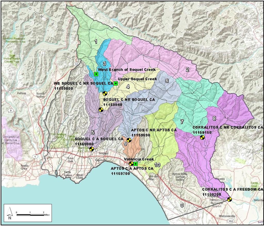
13 Streamflow 10 gages

14 Groundwater Reservoir Stream and/or Groundwater Reservoir Soil-Zone Reservoir Stream and/or Soil-Zone Reservoir Calibrate Soil Zone Parameters 15 Parameters Recommended by USGS Coefficients for flow routing Storage capacities Percentage area contributing to runoff Evaporation & Transpiration Evaporation Upslope Flow Soil-Zone Reservoir Impervious-Zone Reservoir Surface runoff Fast and Slow Interflow Groundwater Recharge Upslope Flow Groundwater Reservoir Groundwater flow Groundwater Sink


")
15 Grouping by Geology Calibration Zones Group HARDROCK(4) PURISIMA (2) Undifferentiated PURISIMA (3) AROMAS (1)
16 The PEST Model (Batch File) PAR2PAR PRMS TSPROC
17 Calibrate Soil Zone Parameters PAR2PAR Translates Zone Based Parameter Values to HRU Parameter Values Creates HRU Based PRMS Input PRMS TSPROC
18 Calibration to Streamflow PAR2PAR PRMS TSPROC Process Streamflow Timeseries Data Daily Mean annual Monthly mean Mean monthly Nash-Sutcliffe

19 Daily Calibration Plots from PRMS Gage 5 Red = Measured Blue = Simulated Gage 8 Green = Measured Yellow = Simulated

20 Daily Calibration Data from PRMS Gage 5 Red = Measured Blue = Simulated Gage 8 Green = Measured Yellow = Simulated
21 Mean Annual Flow Rate "J 1 +U +U 4 3 "J 2 +U 5 +U U "J +U 7 +U 8
22 Model Calibration Monthly Mean Mean Monthly "J 1 +U +U 4 3 "J 2 +U 5 +U U "J +U 7 +U 8
23 Monthly Mean Flow Rate Calibration Statistics Mean Error = -0.4 Absolute Mean Error = 3.7 Standard Deviation = 8.7 Standard Deviation/Range = 1%
24 Nash-Sutcliffe Goodness of Fit Gage NS < , 1987, none 4 none 5 none , , NA
25 Nash-Sutcliffe Goodness of Fit One day causes NS < 0 Removing one day, moves 1989 NS to 0.4
26 Model Results 4 Purisima Aquifer P a c i f i c O c e a n Aromas Aquifer Purisima = 51 miles 2 Aromas = 14 miles 2 All units in Acre-Feet per Year
27 4 Year Deep Recharge, acre-feet Drought Curtailment Criteria Based on recharge shortfall estimated from 3 year rainfall totals, SqCWD declared Stage 3 drought curtailment in , ,000 Santa Cruz Stn Identified False Positive Allowable Shortfall Unidentified 97 in. 80,000 thru 2/15 60,000 40,000 20,000 0 Stage Year Rainfall through March
28 Acknowledgements Soquel Creek Water District Central Water District City of Santa Cruz US Geological Survey
1 THE USGS MODULAR MODELING SYSTEM MODEL OF THE UPPER COSUMNES RIVER
 1 THE USGS MODULAR MODELING SYSTEM MODEL OF THE UPPER COSUMNES RIVER 1.1 Introduction The Hydrologic Model of the Upper Cosumnes River Basin (HMCRB) under the USGS Modular Modeling System (MMS) uses a
Santa Cruz Mid-County Groundwater Model: PRMS Setup Page 1
 Santa Cruz Mid-County Groundwater Model: PRMS Setup Page 1 Contents Abbreviations... 2 1. Introduction... 3 2. Modeling Approach... 5 3. Model Discretization... 6 4. PRMS Modules... 8 5. Input Data...
GROUNDWATER MODELING A PRIMER FOR THE COMMUNITY
 GROUNDWATER MODELING A PRIMER FOR THE COMMUNITY Public Orientation Session #4 Presenter: Cameron Tana, HydroMetrics Water Resources Inc. Thursday, December 7, 2017 Objectives and Outline Objectives 1.
TECHNICAL MEMORANDUM
 519 17th Street, Suite 500 Oakland, CA 94612 To: From: TECHNICAL MEMORANDUM Kim Adamson, Soquel Creek Water District Ralph Bracamonte, Central Water District Cameron Tana and Derrik Williams Date: January
BAEN 673 / February 18, 2016 Hydrologic Processes
 BAEN 673 / February 18, 2016 Hydrologic Processes Assignment: HW#7 Next class lecture in AEPM 104 Today s topics SWAT exercise #2 The SWAT model review paper Hydrologic processes The Hydrologic Processes
Subject: Groundwater Model Update and Scope for Fiscal Year
 1814 Franklin St, Suite 501 Oakland, CA 94612 Mr. Ron Duncan General Manager, Soquel Creek Water District On behalf of Santa Cruz Mid County Groundwater Agency Executive Staff PO Box 1550 Capitola, CA
Mid-County Basin Groundwater Hydrology and Management
 Mid-County Basin Groundwater Hydrology and Management Presented on July 8, 2014 to Mid-County Groundwater Stakeholder Advisory Group Santa Cruz County HydroMetrics WRI Introduction Consulting groundwater
CONTINUOUS RAINFALL-RUN OFF SIMULATION USING SMA ALGORITHM
 CONTINUOUS RAINFALL-RUN OFF SIMULATION USING SMA ALGORITHM INTRODUCTION Dr. R N Sankhua Director, NWA, CWC, Pune In this continuous rainfall-runoff simulation, we will perform a continuous or long-term
Introduction. Welcome to the Belgium Study Abroad Program. Courses:
 Introduction Welcome to the Belgium Study Abroad Program Courses: AGSM 335: Soil and Water Management BAEN 460: Principals of Environmental Hydrology BAEN 460 / AGSM 335 Combined lecture and HW sessions
Study of Hydrology based on Climate Changes Simulation Using SWAT Model At Jatiluhur Reservoir Catchment Area
 Study of Hydrology based on Climate Changes Simulation Using SWAT Model At Jatiluhur Reservoir Catchment Area Budi Darmawan Supatmanto 1, Sri Malahayati Yusuf 2, Florentinus Heru Widodo 1, Tri Handoko
M.L. Kavvas, Z. Q. Chen, M. Anderson, L. Liang, N. Ohara Hydrologic Research Laboratory, Civil and Environmental Engineering, UC Davis
 Assessment of the Restoration Activities on Water Balance and Water Quality at Last Chance Creek Watershed Using Watershed Environmental Hydrology (WEHY) Model M.L. Kavvas, Z. Q. Chen, M. Anderson, L.
Southern Sierra Headwaters Tour
 Southern Sierra Headwaters Tour Introduction The headwaters of the Sierra Nevada support the needs of California s diverse downstream communities, economies, and environments. On this tour and in our research,
Turbidity Monitoring Under Ice Cover in NYC DEP
 Turbidity Monitoring Under Ice Cover in NYC DEP Reducing equifinality by using spatial wetness information and reducing complexity in the SWAT-Hillslope model Linh Hoang 1,2, Elliot M. Schneiderman 2,
Measuring and Valuing Ecosystem Services: InVEST and Modeling Approaches
 Measuring and Valuing Ecosystem Services: InVEST and Modeling Approaches Adrian L. Vogl Comparative Groundwater Law & Policy Workshop April 9, 2013 A Modeling Approach Simple conceptual reservoir models
M.L. Kavvas, Z. Q. Chen, M. Anderson, L. Liang, N. Ohara Hydrologic Research Laboratory, Civil and Environmental Engineering, UC Davis
 Assessment of the Restoration Activities on Water Balance and Water Quality at Last Chance Creek Watershed Using Watershed Environmental Hydrology (WEHY) Model M.L. Kavvas, Z. Q. Chen, M. Anderson, L.
Forests and Water in the Sierra Nevada. Roger Bales, Sierra Nevada Research Institute, UC Merced
 Forests and Water in the Sierra Nevada Roger Bales, Sierra Nevada Research Institute, UC Merced Some motivating points Water is the highest-value ecosystem service associated with Sierra Nevada conifer
Technical Memorandum
 Specialists in Agricultural Water Management Serving Stewards of Western Water since 1993 To: From: Technical Memorandum Butte County Department of Water and Resource Conservation Davids Engineering Date:
Application of the PRMS model in the Zhenjiangguan watershed in the Upper Minjiang River basin
 doi:10.5194/piahs-368-209-2015 Remote Sensing and GIS for Hydrology and Water Resources (IAHS Publ. 368, 2015) (Proceedings RSHS14 and ICGRHWE14, Guangzhou, China, August 2014). 209 Application of the
Impacts of 2015 Drought on Streamflow in the Columbia River Basin
 Impacts of 2015 Drought on Streamflow in the Columbia River Basin Chris Konrad US Geological Survey Tacoma, WA May 11, 2016 1 Overview of USGS Investigation Western US had low snowpack, warm temperatures,
Effect of forest management on water yields & other ecosystem services in Sierra Nevada forests UCB/UC Merced/UCANR project
 Effect of forest management on water yields & other ecosystem services in Sierra Nevada forests UCB/UC Merced/UCANR project Some motivating points Water is the highest-value ecosystem service associated
Mapping Groundwater Recharge Rates Under Multiple Future Climate Scenarios in Southwest Michigan
 http://mi.water.usgs.gov/reports/images/cover_med01_4227.jpg Mapping Groundwater Recharge Rates Under Multiple Future Climate Scenarios in Southwest Michigan Glenn O Neil Institute of Water Research Michigan
Influence of evapotranspiration estimates on the water balance of sugarcane cropping system in the Hawaiian island of Maui
 Influence of evapotranspiration estimates on the water balance of sugarcane cropping system in the Hawaiian island of Maui Javier Osorio, Jaehak Jeong & Jeff Arnold Presented by: Allan Jones 2013 International
Application of a Basin Scale Hydrological Model for Characterizing flow and Drought Trend
 Application of a Basin Scale Hydrological Model for Characterizing flow and Drought Trend 20 July 2012 International SWAT conference, Delhi INDIA TIPAPORN HOMDEE 1 Ph.D candidate Prof. KOBKIAT PONGPUT
Hydrologic Cycle. Water Availabilty. Surface Water. Groundwater
 Hydrologic Cycle Hydrologic ydoogccyce cycle Surface Water Groundwater Water Availabilty 1 Hydrologic Cycle Constant movement of water above, on, and, below the earth s surface (Heath) Endless circulation
TECHNICAL NOTE: ESTIMATION OF FRESH WATER INFLOW TO BAYS FROM GAGED AND UNGAGED WATERSHEDS. T. Lee, R. Srinivasan, J. Moon, N.
 TECHNICAL NOTE: ESTIMATION OF FRESH WATER INFLOW TO BAYS FROM GAGED AND UNGAGED WATERSHEDS T. Lee, R. Srinivasan, J. Moon, N. Omani ABSTRACT. The long term estimation of fresh water inflow to coastal bays
Toward an Improvement of the Hydrological Performance of the SWAT Model under Snow Cover and during Snowmelt
 Toward an Improvement of the Hydrological Performance of the SWAT Model under Snow Cover and during Snowmelt Étienne Lévesque, Nicolas Beauchamp geau, Université Laval, Québec, Canada Ann van Griensven
Ottawa County Water Resources Study Phase 2
 Ottawa County Water Resources Study Phase 2 Overview David P. Lusch, Ph.D. Department of Geography and Institute of Water Research Michigan State University 1 / 24 Ottawa County Planning and Performance
Evaluation of Swat for Modelling the Water Balance and Water Yield in Yerrakalva River Basin, A.P. National Institute of Hydrology, Roorkee
 Evaluation of Swat for Modelling the Water Balance and Water Yield in Yerrakalva River Basin, A.P. By Dr. J.V. Tyagi Dr. Y.R.S. Rao National Institute of Hydrology, Roorkee INTRODUCTION Knowledge of water
Thanks to Bill Elliot, Research Leader U.S. Department of Agriculture Forest Service
 Thanks to Bill Elliot, Research Leader U.S. Department of Agriculture Forest Service To present an overview Forest Soil Erosion Processes 2 Precipitation or melting snow Evapotranspiration Infiltration
Simulation of Basin Runoff due to Rainfall and Snowmelt
 Simulation of Basin Runoff due to Rainfall and Snowmelt Zeinivand, H. 1, 2, F. De Smedt 1 and A. Bahremand 3 1 Department of Hydrology and Hydraulic Engineering, Vrije Universiteit Brussel, Brussels, Belgium
Utilization of the SWAT Model and Remote Sensing to Demonstrate the Effects of Shrub Encroachment on a Small Watershed
 Utilization of the SWAT Model and Remote Sensing to Demonstrate the Effects of Shrub Encroachment on a Small Watershed Jason Afinowicz Department of Biological and Agricultural Engineering Texas A&M University
USDA-NRCS, Portland, Oregon
 Hydrologic Simulation Modeling for Streamflow Forecasting and Evaluation of Land and Water Management Practices in the Sprague River, Upper Klamath Basin, Oregon, USA David Garen John Risley Jolyne Lea
2. Watershed Modeling using HSPF
 2. Watershed Modeling using HSPF Transport models, whether for rivers, lakes or estuaries, generally require a prediction of the amount of rain water runoff that occurs during storms. Models that make
Institute of Water and Flood Management, BUET, Dhaka. *Corresponding Author, >
 ID: WRE 002 HYDROLOGICAL MODELING FOR THE SEMI UNGAUGED BRAHMAPUTRA RIVER BASIN USING SWAT MODEL S. Paul 1*, A.S. Islam 1, M. A. Hasan 1, G. M.T. Islam 1 & S. K. Bala 1 1 Institute of Water and Flood Management,
Simulation of basin runoff due to rainfall and snowmelt
 Simulation of basin runoff due to rainfall and snowmelt Zeinivand, H. 1, 2, F. De Smedt 1 and A. Bahremand 3 1 Department of Hydrology and Hydraulic Engineering, Vrije Universiteit Brussel, Brussels, Belgium
Lecture 9A: Drainage Basins
 GEOG415 Lecture 9A: Drainage Basins 9-1 Drainage basin (watershed, catchment) -Drains surfacewater to a common outlet Drainage divide - how is it defined? Scale effects? - Represents a hydrologic cycle
Hydrologic Modeling with the Distributed-Hydrology- Soils- Vegetation Model (DHSVM)
") Hydrologic Modeling with the Distributed-Hydrology- Soils- Vegetation Model (DHSVM) DHSVM was developed by researchers at the University of Washington and the Pacific Northwest National Lab 200 Simulated
Hydrologic Modeling with the Distributed-Hydrology- Soils- Vegetation Model (DHSVM) DHSVM was developed by researchers at the University of Washington and the Pacific Northwest National Lab 200 Simulated
The Impact of Wetland Drainage on the Hydrology of a Northern Prairie Watershed
 John Pomeroy, Xing Fang, Stacey Dumanski, Kevin Shook, Cherie Westbrook, Xulin Guo, Tom Brown, Adam Minke, Centre for Hydrology, University of Saskatchewan, Saskatoon, Canada The Impact of Wetland Drainage
Prairie Hydrology. If weather variability increases, this could degrade the viability of many aspects of ecosystems, human activities and economy
 Prairie Hydrology John Pomeroy, Xing Fang, Robert Armstrong, Tom Brown, Kevin Shook Centre for Hydrology, University of Saskatchewan, Saskatoon, Canada Climate Change for the Prairies? Highly variable
Ungauged drainage basins: Investigation on the basin of Peneios River, Thessaly, Greece
 European Water 57: 163-169, 2017. 2017 E.W. Publications Ungauged drainage basins: Investigation on the basin of Peneios River, Thessaly, Greece V. Gourgoulios and I. Nalbantis * Centre for the Assessment
Physically-based Distributed Hydrologic Modeling
 Physically-based Distributed Hydrologic Modeling Goal of Phys.-based Distrib. Hydrologic Modeling To date we have learned about: Key forcings at land surface (precipitation/net radiation) Physical processes
PRMS-IV, the Precipitation-Runoff Modeling System, Version 4
 PRMS-IV, the Precipitation-Runoff Modeling System, Version 4 Chapter 7 of Section B, Surface Water Book 6, Modeling Techniques Techniques and Methods 6 B7 U.S. Department of the Interior U.S. Geological
are sufficiently different that his models are not useful to us at this stage. We anticipate, however, that he can provide submodels
 INTERNAL REPORT 20 HYDROLOGIC MODEL FOR WATERSHED 10, ANDREWS EXPERIMENTAL FOREST Round 1 George Brown, Dick Fredriksen, and Scott Overton School of Forestry, Oregon State University BACKGROUND Watershed
Hydrology Review, New paradigms, and Challenges
 Hydrology Review, New paradigms, and Challenges Intent quick introduction with emphasis on aspects related to watershed hydrochemistry and new paradigms Watershed / Catchment Definition Portion of landscape
DEPARTMENT OF GEOGRAPHY POST GRADUATE GOVT. COLLEGE FOR GIRLS.SECTOR-11 CHANDIGARH CLASS-B.A.II PAPER-A RESOURCES AND ENVIRONMENT: WORLD PATTERNS
 DEPARTMENT OF GEOGRAPHY POST GRADUATE GOVT. COLLEGE FOR GIRLS.SECTOR-11 CHANDIGARH CLASS-B.A.II PAPER-A RESOURCES AND ENVIRONMENT: WORLD PATTERNS Hydrological cycle The sun, which drives the water cycle,
Soquel-Aptos Water. Let s get to the right questions
 Soquel-Aptos Water Let s get to the right questions Water How much is pumped by each stakeholder group? How much to maintain outflows to ocean; and for recharging streams? How to better calc rural use
Texas A & M University and U.S. Bureau of Reclamation Hydrologic Modeling Inventory Model Description Form
 Texas A & M University and U.S. Bureau of Reclamation Hydrologic Modeling Inventory Model Description Form JUNE 18, 1999 Name of Model: MIKE 11 RR (Rainfall Runoff) Model Type: The MIKE 11 RR model is
Surface Water Accounting Model, SWAc linking surface flow and recharge processes to groundwater models
 Surface Water Accounting Model, SWAc linking surface flow and recharge processes to groundwater models Alastair Black 1, Marco Lagi 2 1 Groundwater Science Ltd (a.black@gwscience.co.uk) 2 New England Complex
Scale Effects in Large Scale Watershed Modeling
 Scale Effects in Large Scale Watershed Modeling Mustafa M. Aral and Orhan Gunduz Multimedia Environmental Simulations Laboratory School of Civil and Environmental Engineering Georgia Institute of Technology
Estimating Groundwater Recharge under Upland and Depression Using a Simple Soil Water Balance Model
 Estimating Groundwater Recharge under Upland and Depression Using a Simple Soil Water Balance Model Ligang Xu, Masaki Hayashi, John Jackson and Laurence R. Bentley Department of Geosciences, University
Topography and the Spatial Distribution of Groundwater Recharge and Evapotranspiration:
 Topography and the Spatial Distribution of Groundwater Recharge and Evapotranspiration: A Need to Revisit Distributed Water Budget Analysis when Assessing Impacts to Ecological Systems. By M.A. Marchildon,
Workshop 1 Our Groundwater and Surfacewaters are Connected and We are What We Drink Hosted by: Lackawanna County Conservation District
 Workshop 1 Our Groundwater and Surfacewaters are Connected and We are What We Drink Hosted by: Lackawanna County Conservation District Sponsored by: Pocono Northeast RC&D Council Through the C-SAW C Program
Watersheds and the Hydrologic Cycle
 Watersheds and the Hydrologic Cycle The Global Hydrologic Cycle Water Cycle in Florida Florida Water Facts Surface Area = 170,452 km 2 Average Rainfall = 140 cm (55 ) Total Annual Rain = 238 billion m
Modelling of the Hydrology, Soil Erosion and Sediment transport processes in the Lake Tana Catchments of Blue Nile River Basin, Ethiopia
 Modelling of the Hydrology, Soil Erosion and Sediment transport processes in the Lake Tana Catchments of Blue Nile River Basin, Ethiopia Combining Field Data, Mathematical Models and Geographic Information
Runoff Processes. Daene C. McKinney
 CE 374 K Hydrology Runoff Processes Daene C. McKinney Watershed Watershed Area draining to a stream Streamflow generated by water entering surface channels Affected by Physical, vegetative, and climatic
GIS Applications in Water Resources Engineering
 King Fahd University of Petroleum & Minerals City & Regional Planning Department Introduction to Geographic Information Systems Term Paper Presentation GIS Applications in Water Resources Engineering Prepared
General Groundwater Concepts
 General Groundwater Concepts Hydrologic Cycle All water on the surface of the earth and underground are part of the hydrologic cycle (Figure 1), driven by natural processes that constantly transform water
Effects of land use change on the water resources of the Basoda basin using the SWAT model
 INDIAN INSTITUTE OF TECHNOLOGY ROORKEE Effects of land use change on the water resources of the Basoda basin using the SWAT model By Santosh S. Palmate* 1 (Ph.D. Student) Paul D. Wagner 2 (Postdoctoral
2.3 Water Budget Data In Ontario
 2.3 Water Budget Data In Ontario Water budget data available for Ontario includes meteorologic data, hydrometric data and groundwater data. Geological and physiographical data provide information to describe
WMS Tools For Computing Hydrologic Modeling Parameters
 WMS Tools For Computing Hydrologic Modeling Parameters Lesson 9 9-1 Objectives Use the drainage coverage as a basis for geometric parameters as well as overlaying coverages to compute important hydrologic
Assessing Real Time - Drainage Water Management
 Assessing Real Time - Drainage Water Management Jim Klang, PE Kieser & Associates, LLC 536 East Michigan Ave / Suite 300, Kalamazoo, MI 49007 (269) 344-7117 Photo Credit: Purdue Engineering Today s Talk
San Diego Hydrology Model (SDHM 3.0) Reviewer Workshop. Doug Beyerlein, P.E., P.H., D.WRE Clear Creek Solutions, Inc. Mill Creek, Washington
 Reviewer Workshop. Doug Beyerlein, P.E., P.H., D.WRE Clear Creek Solutions, Inc. Mill Creek, Washington") San Diego Hydrology Model (SDHM 3.0) Reviewer Workshop Doug Beyerlein, P.E., P.H., D.WRE Clear Creek Solutions, Inc. Mill Creek, Washington Clear Creek Solutions Hydrology Expertise Clear Creek Solutions,
San Diego Hydrology Model (SDHM 3.0) Reviewer Workshop Doug Beyerlein, P.E., P.H., D.WRE Clear Creek Solutions, Inc. Mill Creek, Washington Clear Creek Solutions Hydrology Expertise Clear Creek Solutions,
Introduction to Hydrological Models. University of Oklahoma/HyDROS Module 1.2
 Introduction to Hydrological Models University of Oklahoma/HyDROS Module 1.2 Outline Day 1 WELCOME INTRODUCTION TO HYDROLOGICAL MODELS The water cycle Defining hydrological processes Modeling hydrological
SNAMP water research. Topics covered
 SNAMP water research SNAMP water team UC Merced Topics covered Objectives, goals & overview What & why the water component of SNAMP Pre-treatment Observations Water Quality Water Quantity Modeling & Scenarios:
Malfunctioning of streamgauge stations in the Chanza and Arochete rivers (Huelva, Spain) detected from hydrological modeling with SWAT.
 detected from hydrological modeling with SWAT.") Malfunctioning of streamgauge stations in the Chanza and Arochete rivers (Huelva, Spain) detected from hydrological modeling with SWAT. L. Galván, M. Olías and A. Van Griensven Introduction The Odiel river
Malfunctioning of streamgauge stations in the Chanza and Arochete rivers (Huelva, Spain) detected from hydrological modeling with SWAT. L. Galván, M. Olías and A. Van Griensven Introduction The Odiel river
Hydrologic Cycle. Rain Shadow:
 Hydrologic Cycle The cyclical movement of water from the ocean to the atmosphere by evaporation, to the surface through precipitation, to streams through runoff and groundwater, and back to the ocean.
Comparative analysis of SWAT model with Coupled SWAT-MODFLOW model for Gibbs Farm Watershed in Georgia
 2018 SWAT INTERNATIONAL CONFERENCE, JAN 10-12, CHENNAI 1 Comparative analysis of SWAT model with Coupled SWAT-MODFLOW model for Gibbs Farm Watershed in Georgia Presented By K.Sangeetha B.Narasimhan D.D.Bosch
Managing Forests for Snowpack Storage & Water Yield
 Managing Forests for Snowpack Storage & Water Yield Roger Bales Professor & Director Sierra Nevada Research Institute UC Merced NASA-MODIS satellite image NASA-MODIS satellite image Outline of talk Mountain
Estimating Groundwater Recharge within Wisconsin s Central Sands
 Estimating Groundwater Recharge within Wisconsin s Central Sands Adam Freihoefer and Robert Smail Wisconsin Department of Natural Resources [study objective] Identify a defensible approach to quantify
Hydrologic response to conifer removal and upslope harvest in a montane meadow
 Hydrologic response to conifer removal and upslope harvest in a montane meadow Dr. Chris Surfleet, PhD, Associate Professor Watershed Management and Hydrology, csurflee@calpoly.edu Graduate Research Assistant,
Forecast Informed Reservoir Operations (FIRO) ERDC Hydrologic Investigations
 ERDC Hydrologic Investigations") Forecast Informed Reservoir Operations (FIRO) ERDC Hydrologic Investigations Briefing, May 31, 2017 Background The US Army Corps of Engineers (USACE) operates reservoirs primarily for flood control, with
Forecast Informed Reservoir Operations (FIRO) ERDC Hydrologic Investigations Briefing, May 31, 2017 Background The US Army Corps of Engineers (USACE) operates reservoirs primarily for flood control, with
Report. Environmental Water Demands. Butte County Department of Water and Resource Conservation Integrated Water Resources Plan.
 Report Butte County Department of Water and Resource Conservation Integrated Water Resources Plan s June 2004 s Section 1 - Introduction 1.1 Project Description This project is a preliminary investigation
AN INTEGRATED GROUNDWATER RECHARGE AND FLOW MODEL TO PREDICT BASE FLOW
 AN INTEGRATED GROUNDWATER RECHARGE AND FLOW MODEL TO PREDICT BASE FLOW By XIAOJING NI A THESIS Submitted to Michigan State University in partial fulfillment of the requirements for the degree of Civil
Hydromodification Computer Modeling
 Hydromodification Computer Modeling Douglas Beyerlein, P.E. Clear Creek Solutions, Inc. 15800 Village Green Drive #3 Mill Creek, WA 98012 beyerlein@clearcreeksolutions.com Phone: 425.892.6454 Introduction
USGS Watershed Model Evolution RRM(1972) to GSFLOW(2012) George Leavesley, USGS Retired and Steve Markstrom, USGS, Denver
 to GSFLOW(2012) George Leavesley, USGS Retired and Steve Markstrom, USGS, Denver") USGS Watershed Model Evolution RRM(1972) to GSFLOW(2012) George Leavesley, USGS Retired and Steve Markstrom, USGS, Denver Model Evolution MMS GSFLOW Time DR3M RRM PRMS Mountain Watershed Model MODFLOW
USGS Watershed Model Evolution RRM(1972) to GSFLOW(2012) George Leavesley, USGS Retired and Steve Markstrom, USGS, Denver Model Evolution MMS GSFLOW Time DR3M RRM PRMS Mountain Watershed Model MODFLOW
Song Lake Water Budget
 Song Lake Water Budget Song Lake is located in northern Cortland County. It is a relatively small lake, with a surface area of about 115 acres, and an average depth of about 14 feet. Its maximum depth
GreenPlan Modeling Tool User Guidance
 GreenPlan Modeling Tool User Guidance Prepared by SAN FRANCISCO ESTUARY INSTITUTE 4911 Central Avenue, Richmond, CA 94804 Phone: 510-746-7334 (SFEI) Fax: 510-746-7300 www.sfei.org Table of Contents 1.
MODELING SEDIMENT AND PHOSPHORUS YIELDS USING THE HSPF MODEL IN THE DEEP HOLLOW WATERSHED, MISSISSIPPI
 MODELING SEDIMENT AND PHOSPHORUS YIELDS USING THE HSPF MODEL IN THE DEEP HOLLOW WATERSHED, MISSISSIPPI Jairo Diaz-Ramirez, James Martin, William McAnally, and Richard A. Rebich Outline Background Objectives
Estimating water needs of alfalfa and using ET to schedule Irrigation
 Estimating water needs of alfalfa and using ET to schedule Irrigation D. Zaccaria, R. Snyder, D. Putnam, A. Montazar, C. Little DWR-Funded Project (2014-2017) aiming at Developing updated information on
SECTION IV WATERSHED TECHNICAL ANALYSIS
 A. Watershed Modeling SECTION IV WATERSHED TECHNICAL ANALYSIS An initial step in the preparation of this stormwater management plan was the selection of a stormwater simulation model to be utilized. It
Prairie Hydrological Model Study Progress Report, April 2008
 Prairie Hydrological Model Study Progress Report, April 2008 Centre for Hydrology Report No. 3. J. Pomeroy, C. Westbrook, X. Fang, A. Minke, X. Guo, Centre for Hydrology University of Saskatchewan 117
Collaboratively Modeling Water Resources in the Truckee-Carson River System
 Special Publication 17-04 Collaboratively Modeling Water Resources in the Truckee-Carson River System Kelley Sterle, Doctoral Candidate Graduate Program of Hydrologic Sciences University of Nevada, Reno
Representing the Integrated Water Cycle in Community Earth System Model
 Representing the Integrated Water Cycle in Community Earth System Model Hong-Yi Li, L. Ruby Leung, Maoyi Huang, Nathalie Voisin, Teklu Tesfa, Mohamad Hejazi, and Lu Liu Pacific Northwest National Laboratory
Hands-on Session. Adrian L. Vogl Stanford University
 Hands-on Session Adrian L. Vogl Stanford University avogl@stanford.edu Questions InVEST can answer How much water is available? Where does the water used for hydropower production come from? How much energy
HYDROLOGIC MODELING OF THE APALACHICOLA CHATTAHOOCHEE FLINT RIVER BASIN USING THE U.S. GEOLOGICAL SURVEY PRECIPITATION RUNOFF MODELING SYSTEM
 HYDROLOGIC MODELING OF THE APALACHICOLA CHATTAHOOCHEE FLINT RIVER BASIN USING THE U.S. GEOLOGICAL SURVEY PRECIPITATION RUNOFF MODELING SYSTEM By Jacob H. LaFontaine, 1 Lauren E. Hay, 2 Roland Viger, 3
Hydrologic Model of the Vermilion River Watershed for Streamflow Simulations
 This project was funded through the Illinois Department of Natural Resources and the Illinois State Geological Survey. Illinois State Water Survey Contract Report 2004-0. Hydrologic Model of the Vermilion
Metal Fate and Transport Simulation Using SWAT in the Tri-State Mining District
 Metal Fate and Transport Simulation Using SWAT in the Tri-State Mining District Mehran Niazi, PhD Joseph Schubauer-Berigan, PhD Presenter: Douglas Grosse USEPA Office of Research & Development, National
Integrating wetlands and riparian zones in regional hydrological modelling
 Integrating wetlands and riparian zones in regional hydrological modelling Fred Hattermann, Valentina Krysanova & Joachim Post Potsdam Institute for Climate Impact Research Outline Introduction Model concept:
Watersheds and the Hydrologic Cycle
 Watersheds and the Hydrologic Cycle The Global Hydrologic Cycle Water Cycle in Florida Florida Water Facts Surface Area = 170,452 km 2 Average Rainfall = 140 cm (55 ) Total Annual Rain = 238 billion m
Model to assess the impacts of external drivers on the hydrology of the Ganges River Basin
 76 Evolving Water Resources Systems: Understanding, Predicting and Managing Water Society Interactions Proceedings of ICWRS2014, Bologna, Italy, June 2014 (IAHS Publ. 364, 2014). Model to assess the impacts
Draft Fact Sheet Butte County Stable Isotope Recharge Study
 Agenda Item #4 Draft Fact Sheet Butte County Stable Isotope Recharge Study Purpose of the Study: To develop a better understanding of how various water sources contribute to recharge of Butte County groundwater.
Rainfall, Runoff and Peak Flows: Calibration of Hydrologic Design Methods for the Kansas City Area
 Rainfall, Runoff and Peak Flows: Calibration of Hydrologic Design Methods for the Kansas City Area Bruce McEnroe, Bryan Young, Ricardo Gamarra and Ryan Pohl Department of Civil, Environmental, and Architectural
Using Information from Data Rich Sites to Improve Prediction at Data Limited Sites
 Using Information from Data Rich Sites to Improve Prediction at Data Limited Sites A Challenge for Hydrologic Prediction from Mountain Basins: DANNY MARKS Northwest Watershed Research Center USDA-Agricultural
Hydrologic Modeling of Cedar Creek Watershed using SWAT
 North Central Texas Water Quality Project Hydrologic Modeling of Cedar Creek Watershed using SWAT Balaji Narasimhan, Raghavan Srinivasan, Steve Bernardz and Mark Ernst Cedar Creek Reservoir Total Watershed
Forecasting Hydrological Processes under Combined Climate and Land-Use/Cover Change Scenarios
 Forecasting Hydrological Processes under Combined Climate and Land-Use/Cover Change Scenarios Babak Farjad 1, Anil Gupta 2, and Danielle Marceau 3 1,3 Department of Geomatics Engineering, University of
Assessing the impact of projected climate changes on small coastal basins of the Western US
 Assessing the impact of projected climate changes on small coastal basins of the Western US William Burke Dr. Darren Ficklin Dept. of Geography, Indiana University Introduction How will climate change
APPLICATION OF SWAT MODEL TO THE STUDY AREA
 CHAPTER 5 APPLICATION OF SWAT MODEL TO THE STUDY 5.1 Introduction The Meenachil river basin suffers from water shortage during the six non-monsoon months of the year. The available land and water resources
Michael Cahn and Barry Farrara, UC Cooperative Extension, Monterey Tom Bottoms and Tim Hartz, UC Davis
 Water Use of Strawberries on the Central Coast Michael Cahn and Barry Farrara, UC Cooperative Extension, Monterey Tom Bottoms and Tim Hartz, UC Davis As acreage of strawberries has steadily increased in
LARGE SCALE SOIL MOISTURE MODELLING
 Soil Moisture Workshop LARGE SCALE SOIL MOISTURE MODELLING Giuseppe Formetta, Vicky Bell, and Eleanor Blyth giufor@nerc.ac.uk Centre for Ecology and Hydrology, Wallingford, UK Wednesday 25 th January 2017