Charlottesville Albemarle MPO:
|
|
|
- Brianne Hopkins
- 5 years ago
- Views:
Transcription


1 Charlottesville Albemarle MPO: Applying The Eco-Logical Approach To Small MPOs September 21, 2015 Charlottesville Albemarle Metropolitan Planning Organization (CAMPO) and The Thomas Jefferson Planning District Commission


2 MPO Background Covers the City of Charlottesville and the urbanized areas of Albemarle County Economy centered around the University of Virginia Population 122,638 (2010) 24,297 Students The population is forecasted to grow by 34% by the year 2040 TJPDC encompasses Charlottesville, Albemarle, Nelson, Fluvanna, Louisa, and Greene


 and a key environmental performance measure in the")

3 MPO and Eco-Logical The Charlottesville Albemarle MPO and the Thomas Jefferson Planning District Commission have been local leaders in exploring the link between environment, transportation and land use: 1998 TJPDC and partners adopted Sustainability accords 2009 Green Infrastructure assessment for the Region 2011 Worked with State and local partners to develop a Regional Environmental Framework (REF) using Eco- Logical principals 2013 Used the (REF) and a key environmental performance measure in the LRTP process 2013 Began implementing Eco-Logical into project planning by applying it to a stalled project to add additional road capacity across a river


4 CA-MPO REF Tool CA-MPO REF tool was created to be easy to use and is built on a readily available platform. It also uses datasets that are available for the whole of the State. GIS based Tool Rasterized dataset The result of combining 10 datasets related to species and habitats All input datasets and attributes were ranked by experts on a scale of 2-10 Uses existing GIS functions and tools to conduct analyses
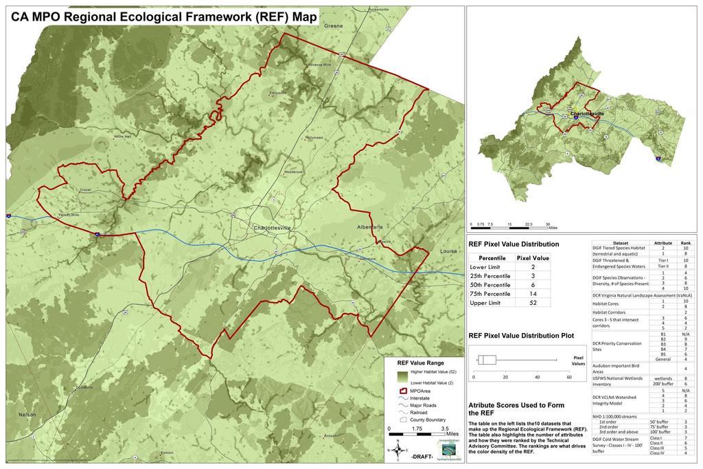
5 REF Tool


6 Eco-Logical Datasets Built with existing datasets Tiered Species Habitat Threatened and and Endangered Species Waters Species observations Natural Landscape Assessment Cores and and Corridors Priority Conservation Sites Sites Important Bird Bird Areas National Wetlands Inventory VCLNA Watershed Integrity Model Cold Cold Water Stream Survey National Hydrography Dataset Ranking Raster system: Ranking 2 system: High scores representing highest value ecosystem areas Prioritizes preservation for for ecosystem areas (especially wetlands)

7 Eco-Logical and Performance Based Planning Quantitative measure Score per mile/per acre Total impact score Provides a way to benchmark projects and scenarios Comparable Allows for multiple environmental considerations

8 Performance Measures Map 21 Establishes a performance based program MPO s Approach Develop regional specific performance measures 16 measures organized into 4 categories Apply performance measures to a scenario based approach Mobility Measures Economic Measures Environmental Measures Community Measures
9 Performance Measures MEASURE DESCRIPTION Mobility Congestion The total percentage of roads that will have a level of service E or F in Delay The total daily hours of delay that congestion will cause in the year Mode Share The percentage of trips across the four main travel modes, automotive, transit, bike and walk for Vehicle Mobility The total system-wide vehicle miles traveled for Vehicle Crashes The total system-wide crashes per year for Economy Access to Jobs The average travel time to work. Transit Accessibility The percentage of population and the percentage of employed individuals within the MPO with access to transit. Environment Habitat Air Quality Water Quality Flood Plain Historical/Archeological sites Community Land Use Environmental Justice and Title VI: Transit Access Environmental Justice and Title VI: Impacts The aggregate impact of projects on natural resources and habitats within 500 foot buffer of project. The percent change in air quality gases and particulates in tons per year. The percent change in the amount of stormwater pollutants in tons per year. The total acreage of flood plain within a 500 foot buffer of the projects. The total number of historic or archeological sites within a 500 foot buffer of these projects. The total number of land parcels within a 500 foot buffer of the potential projects by usage: residential, comm./ind., parks, educ./religious/charitable, and agricultural/undeveloped. The total percentage of Environmental Justice or Title VI groups with access to transit: minorities, 65 and older, limited-english speaking, and household income of less than $25,000. The total percentage of Environmental Justice or Title VI groups potentially impacted due to projects: minorities, 65 and older, limited-english speaking, and household income of less than $25,000.
10 Eco-Logical as a Quantitative Measure Calculated a base score per mile for existing and committed projects Compared the change in the base score between scenarios Expressed as a percent Performance Measure Base Scenario 1A Environmental Measures Value Unit of Measure Value % Change Habitat 1,775.5 Eco-Logical Score/Mile 1, % Air Quality 13,321.0 Tons/Year 13, % Water Quality (% change in 1,079.1 Tons/Year 1, % stormwater pollutants) (tons per year) Flood Plain (acres of 100 year flood plain affected) Historical (designated historic sites within 500 ft. of projects Archeological (designated archeological sites within 500 ft. of projects) 99.1 Acres % 1,141 # of Sites 1, % 264 # of Sites %

11 Eco-Logical s Application to Free Bridge What: Why: How: Development of decision support tools to assist public officials, decision makers, planners, administrators, and the public in reducing conflicts between the built environment and ecosystems. Ecosystem services are provided by green infrastructure. Cost avoidance and revenue are also considerations. Integrate infrastructure and natural resources plans. Allow the Regional Ecological Framework to inform project alternatives. Strategically identify mitigation projects that provide the maximum ecological benefit for the dollars spent. 11


12 History of Free Bridge Constraints of topography and development make capacity improvements to US250 very expensive. Eco-logical: flexible approach to identify best alternative. Allowed MPO to implement a stakeholderdriven process. Previously Discussed Solutions South Pantops Drive 2-Lane Eastern Connector 4-Lane Eastern Connector Limited Access on 250 State Farm Boulevard Widening US 29/250 & 64 Pantops: 1957 (Farms) Pantops: 2013 (Suburban Growth) 12

13 Free Bridge Area Congestion Relief Project 18 month project focused on applying the Eco-Logical approach to a bridge project Key components Building support & understanding for Eco-Logical Stakeholder group of Local experts and advocacy groups Use of a professional facilitator Scenario and project prioritization Ranking of alternatives Alternative Estimated Cost Traffic reduction Construction Feasibility REF Impacts Overall Rank D-2 High Moderate Moderate Moderate High A-1 High High Low Low High G Moderate Low Moderate Low Mod/High F Moderate Low High Moderate Mod/High B LOW n/a Moderate High Moderate I Low n/a High Low Low A-2 LOW n/a High Low Low
14 Stakeholders: Albemarle Board of Supervisors Albemarle County Parks and Recreation Albemarle Planning Commission Albemarle Planning Department CAT Charlottesville Area Transit Charlottesville Bike + Pedestrian Safety Committee Charlottesville City Council Charlottesville Neighborhood Development Services Charlottesville Parks and Recreation Charlottesville Planning Commission Citizens Commercial Property Managers Department of Conservation and Recreation Department of Environmental Quality Department of Game and Inland Fisheries Department of Historic Resources Federal Highway Administration JAUNT Lewis and Clark Exploratory Center Martha Jefferson Hospital Piedmont Environmental Council Rivanna Conservation Society Rivanna Sewer and Water Authority Sierra Club Southern Environmental Law Center StreamWatch Virginia Department of Transportation 14


15 Outcomes Integrated Eco-Logical into Planning MPO LRTP Planning Rural Transportation Planning Project Prioritization for State Funding Pilot Project Demonstrated the use of Eco-Logical on local scale Built support for approach Improved project planning delivery time

16 Links: Project Website: Contact Information: Wood Hudson Sr. Environmental Planner Thomas Jefferson Planning District Commission
FHWA s Eco-Logical Process: Uses in Performance-Based planning
 FHWA s Eco-Logical Process: Uses in Performance-Based planning August 25, 2014 Charlottesville Albemarle Metropolitan Planning Organization (CAMPO) and The Thomas Jefferson Planning District Commission
Free Bridge Congestion Relief Project: Using FHWA s Eco-Logical Process
 Free Bridge Congestion Relief Project: Using FHWA s Eco-Logical Process An Ecosystem Approach to Developing Infrastructure Projects June 27, 2014 Charlottesville Albemarle Metropolitan Planning Organization
Eco-Logical Pilot Project - Free Bridge Congestion Relief Stakeholder Information Handout
 Eco-Logical Pilot Project - Free Bridge Congestion Relief Stakeholder Information Handout Problem: The US 250 link across the Rivanna River known locally as Free Bridge. This bridge is a key connection
University of Virginia Master Planning Committee November 17 th Charlottesville Albemarle Metropolitan Planning Organization
 University of Virginia Master Planning Committee November 17 th 2010 Charlottesville Albemarle Metropolitan Planning Organization 1 Who are we? What is an MPO A Metropolitan Planning Organization is a
10.0 ENVIRONMENTAL INTEGRATION
 10.0 ENVIRONMENTAL INTEGRATION Transportation projects in the Kansas City region commonly face a range of complex, interrelated environmental and community issues. These often relate to NEPA requirements
Chapter #9 TRAVEL DEMAND MODEL
 Chapter #9 TRAVEL DEMAND MODEL TABLE OF CONTENTS 9.0 Travel Demand Model...9-1 9.1 Introduction...9-1 9.2 Overview...9-1 9.2.1 Study Area...9-1 9.2.2 Travel Demand Modeling Process...9-3 9.3 The Memphis
DIVERSIFIED RURAL COMMUNITY ROLE COUNCIL ROLE DIVERSIFIED RURAL ALL COMMUNITIES
 Orderly and Efficient Land Use Align land use, development patterns, and infrastructure to make the best use of public and private investment. Plan for growth not to exceed forecasts and in patterns that
Eco-logical: Integrating Green Infrastructure and Regional Transportation Planning
 Eco-logical: Integrating Green Infrastructure and Regional Transportation Planning Thomas Jefferson Planning District Commission 401 E. Water Street Charlottesville, Virginia 22902 (434) 979-7310 www.tjpdc.org
RURAL CENTER COMMUNITY ROLE COUNCIL ROLE RURAL CENTER ALL COMMUNITIES
 Orderly and Efficient Land Use Align land use, development patterns, and infrastructure to make the best use of public and private investment. Plan for forecasted population and household growth at overall
RURAL RESIDENTIAL COMMUNITY ROLE COUNCIL ROLE RURAL RESIDENTIAL ALL COMMUNITIES
 Orderly and Efficient Land Use Align land use, development patterns, and infrastructure to make the best use of public and private investment. Discourage future development of rural residential patterns
Summary of transportation-related goals and objectives from existing regional plans
 SMTC 2050 Long Range Transportation Plan Appendix A: Summary of transportation-related goals and objectives from existing regional plans SMTC 2050 Long Range Transportation Plan Summary of transportation-related
Environmental Assessment of Rail Infrastructure in Illinois
 Environmental Assessment of Rail Infrastructure in Illinois Presentation at the 16 th Railroad Environmental Conference, October 28, 2014. Ning Ai, Marcella Bondie, Anthony Grande, Shuo Ma & Shi Yin Outline
SUBURBAN EDGE COMMUNITY ROLE COUNCIL ROLE ALL COMMUNITIES SUBURBAN EDGE
 Orderly and Efficient Land Use Align land use, development patterns, and infrastructure to make the best use of public and private investment. Plan and stage development for forecasted growth through 2040
Sustainability Metrics and Mapping Tool for Environmental Assessment of Rail Infrastructure in Illinois
 Sustainability Metrics and Mapping Tool for Environmental Assessment of Rail Infrastructure in Illinois Webcast at the Center for Urban Transportation Research, USF December 11, 2014 Ning Ai, Ph.D. Assistant
Table Table 7.2 Potential Environmental Impacts and Mitigation Measures
 7.2 Natural Environment/Environmental Planning Executive Summary/Key Points The Environmental Consultation and Mitigation Plan establishes: o A process for consultation with environmental resource agencies
TRANSPORTATION. Albemarle s transportation network will be increasingly multimodal, environmentally sound, well maintained, safe, and reliable.
 Source: Albemarle County Community Development 2011 TRANSPORTATION GOAL: Albemarle s transportation network will be increasingly multimodal, environmentally sound, well maintained, safe, and reliable.
MOBILITY AND ALTERNATIVES ANALYSIS
 6 MOBILITY AND ALTERNATIVES ANALYSIS BACK OF SECTION DIVIDER 6.0 Mobility and Alternatives Analysis Travel demand analysis provides a framework for the identification of transportation facilities and services
Tri-County Regional Planning Commission 2045 Regional Metropolitan Transportation Plan Goals and Objectives Adopted March 22, 2017
 Tri-County Regional Planning Commission 2045 Regional Metropolitan Transportation Plan Goals and Objectives Adopted March 22, 2017 One of the initial steps in the development of the TCRPC 2045 Metropolitan
MEETING SUMMARY FOR APRIL 13, 2017
 SARASOTA/MANATEE METROPOLITAN PLANNING ORGANIZATION Performance Measures/Project Prioritization Process Ad Hoc Committee 7632 15 th Street East Sarasota, Florida 34243 3:00-5:00 PM MEETING SUMMARY FOR
2040 Long Range Transportation Plan
 2040 Long Range Transportation Plan Executive Summary Adopted April 15, 2013 The Current Situation The George Washington Region includes the City of Fredericksburg and the counties of Caroline, King George,
GOALS AND PERFORMANCE MEASURES
 PLANNING FRAMEWORK The planning framework guides the development of the Regional Transportation Plan, articulating what the region is trying to achieve. This chapter establishes a foundation to focus data-gathering
Reference 4: Natural Resources
 Reference 4: Natural Resources This information is intended to provide greater detail and background information on items described in the Natural Resources Chapter of the Comprehensive Plan. Items in
11. Prioritizing Farmlands for Future Protection
 11. Prioritizing Farmlands for Future Protection Identification of Important Farmlands in Putnam County I n order to implement this Plan successfully, Putnam County decision-makers will have to take advantage
City of Charlottesville MEMO
 City of Charlottesville MEMO TO: City Council FROM: Missy Creasy, Planning Manager DATE: August 7, 2013 SUBJECT: A World Class City www.charlottesville.org 2013 Comprehensive Plan Outline of updates made
SCENARIO PLANNING 12
 12 SCENARIO PLANNING Scenario planning represents the next generation of analytical processes created to evaluate the influence of development intensities and land use patterns on the efficiency of a proposed
UVA Master Planning Council. Local Sustainability Initiatives
 UVA Master Planning Council Local Sustainability Initiatives Built Environment Transportation Natural Systems Conservation Education & Communication Environmental Mgmt. System Climate Protection Sustainability
2045 Long Range Transportation Plan Scope
 2045 Long Range Transportation Plan Scope CONTENTS Scope Background... 1 Introduction:... 1 Tasks and Subtasks... 1 1)Background... 1 1-A Community Data and Demographics... 1 1-B Review of Current Plans...
Growth in the Fresno Metro Area
 1 Growth in the Fresno Metro Area 2 A Unique Opportunity Meeting City and Regional Challenges SEGA 9,000 Acres 3 A Unique Planning Process Measuring Up to the Challenge Modeling the Impacts of Different
Highest Priority Performance Measures for the TPP
 Highest Priority Performance Measures for the TPP The following list of measures are the highest priority performance measures as identified by modal working groups. These groups consist of staff from
Strategic Plan Charlottesville-Albemarle MPO May 25, 2016
 Strategic Plan Charlottesville-Albemarle MPO May 25, 2016 Introduction In Fiscal Year 2016, the Charlottesville-Albemarle Metropolitan Planning Organization (CA-MPO) adopted its first Strategic Plan, setting
Final Regional 2035 Transportation Plan Adopted: January 21, 2010
 Final Regional 2035 Transportation Plan Adopted: January 21, 2010 Paul T. Hamilton, Chief Planner Tri-County Regional Planning Commission Federal Requirement Safe Accountable Fair and Efficient Transportation
Regional Performance Measures Annual Progress Report TPO Board - 2/4/2016 Presentation by: Chris Wichman, Senior Planner
 2015 TPO Board - 2/4/2016 Presentation by: Chris Wichman, Senior Planner Overview History and definition of performance-based planning & programming Review of 2015 TPO Board Action Requested 2 History
REGIONAL PLANNING AND POLICY FRAMEWORK A Preferred Approach for our Regional Growth
 REGIONAL PLANNING AND POLICY FRAMEWORK A Preferred Approach for our Regional Growth The Regional Comprehensive Plan (RCP) establishes a new approach to planning in the San Diego region. This approach is
Lubbock Outer Route Feasibility Study Report Executive Summary
 Lubbock Outer Route Feasibility Study Report Executive Summary Prepared for: Texas Department of Transportation Lubbock District Prepared by: MACTEC Engineering and Consulting, Inc. 6701 Aberdeen, Suite
EIGHT PLANNING FACTORS
 EIGHT PLANNING FACTORS Under the provisions of SAFETEA-LU, all Metropolitan Planning Organizations (MPOs) are required to consider eight (8) broad planning factors in the development of multi-modal transportation
Draft Land Use, Scenario Planning, & Sustainability Technical Report. Summary
 ` Draft Land Use, Scenario Planning, & Sustainability Technical Report Summary Introduction In 2006, the Genesee County Metropolitan Planning Commission (GCMPC) performed an analysis of the past and current
Appendix F: Scenario Planning
 Appendix F Scenario Planning Appendix F: Scenario Planning This technical memorandum discusses scenario planning, a visioning tool for the future of Missouri freight and freight planning. Why scenario
Land Use Regulations Update. Robert W. Hofrichter Assistant Administrator, Maintenance Division December 3, 2008
 Land Use Regulations Update Robert W. Hofrichter Assistant Administrator, Maintenance Division December 3, 2008 Access Management Principal Arterials 24 VAC 30-72-10 et seq All Other Highways 24 VAC 30-73-10
PennDOT Office of Planning
 Every Voice Counts PennDOT Office of Planning Environmental Justice Plan Executive Summary Developed for: Pennsylvania Department of Transportation Office of Planning Center for Program Development and
Using A Connected Landscape Strategy to Conserve Virginia s Forests
 Using A Connected Landscape Strategy to Conserve Virginia s Forests Karen Firehock, Green Infrastructure Center Tomorrow Woods Workshop June 12, 2012 Session Route Natural Assets Assessment and Mapping
Land Use, Scenario Planning, & Sustainability Technical Report. Summary
 ` Land Use, Scenario Planning, & Sustainability Technical Report Summary Introduction In 2006, the Genesee County Metropolitan Planning Commission (GCMPC) performed an analysis of the past and current
Chapter 14 Work Program
 Chapter 14 Work Program The Metropolitan Council will carry out or participate in many studies and plans over the next three years. This is not an exhaustive list of all work to be completed by the Metropolitan
Rio/29 Phase 1 Briefing. Rio/29 Small Area Plan Phase 1 January 18, 2017
 Rio/29 Phase 1 Briefing Rio/29 Small Area Plan Phase 1 January 18, 2017 PRESENTATION OVERVIEW 1 PROCESS 2 KEY CONCEPTS & CONCLUSIONS 3 APPLYING THE CONCEPT AT RIO/29 4 5 CHALLENGES & OPPORTUNITIES NEXT
Regional Transportation Performance Measures
 Regional Transportation Performance Measures March 5, 2014 Presented by Tom Murtha Regional Transportation Performance 2 Measures: Introduction Regional Transportation Performance Measures address needs
New York Metropolitan Transportation Council. Plan Regional Transportation Plan A Shared Vision for a Sustainable Region
 New York Metropolitan Transportation Council Plan 2040 Regional Transportation Plan A Shared Vision for a Sustainable Region ADOPTED ON SEPTEMBER 4, 2013 Disclaimer This document was funded in part through
1RUWKZHVW#:LFKLWD 0DMRU#,QYHVWPHQW#6WXG\
 1RUWKZHVW#:LFKLWD 0DMRU#,QYHVWPHQW#6WXG\ Executive Summary 3UHSDUHGýIRUã 3UHSDUHGýE\ã.DQVDVý'HSDUWPHQWýRI 7UDQVSRUWDWLRQ,QýDVVRFLDWLRQýZLWKã (DUWKý7HFKý,QFï EXECUTIVE SUMMARY Introduction This Northwest
12 Evaluation of Alternatives
 12 Evaluation of Alternatives This chapter evaluates the effectiveness of the No-Build Alternative and the proposed METRO Blue Line Light Rail Transit (BLRT) Extension project based on the information
NEPA and Design Public Hearings
 NEPA and Design Public Hearings Monday, December 5, 2016 Washington-Lee High School 1301 N. Stafford Street Arlington, VA 22201 Thursday, December 8, 2016 Mary Ellen Henderson Middle School 7130 Leesburg
EXECUTIVE SUMMARY REGIONAL TRANSPORTATION PLAN 2050
 EXECUTIVE SUMMARY REGIONAL TRANSPORTATION PLAN 2050 Introduction Goals Policies, and Performance Measures Growth Forecast and Planned Land Use Development Key Recommendations i Executive Summary April
Contents i Contents Page 1 A New Transportation Plan Community Involvement Goals and Objectives... 11
 Contents i Contents 1 A New Transportation Plan... 1 Why develop a new plan?... 1 What area does the LRTP focus on?... 2 Why is this LRTP important?... 3 Meeting Requirements for Transportation Planning...
SR 417 Extension. June 2003 INTRODUCTION AND HISTORY PROJECT SCOPE AND PURPOSE STUDY OBJECTIVE STUDY PHASES
 Planning Feasibility Study June 2003 INTRODUCTION AND HISTORY The SR 417 Extension Study was a yearlong effort undertaken by Florida s Turnpike Enterprise to investigate the feasibility of a new toll road
INTERSTATE CORRIDOR PLANNING
 INTERSTATE CORRIDOR PLANNING Prioritization of Corridor Studies July 29, 2015 Importance of the Interstate System Texas is an integral part of the national interstate system. The interstate system provides
Transportation Facility Inventory
 CHAPTER 3 Transportation Element Section 3.1 Introduction Movement of people, goods, and services within and through the Town is an integral part of everyday life for the citizens of Hull. Decisions made
Alternatives Evaluation Methodology
 Alternatives Evaluation Methodology www.vision54 56.com B 1 Phase 2 Alternatives Evaluation Methodology PASCO COUNTY METROPOLITAN PLANNING ORGANIZATION 8731 Citizens Drive New Port Richey, FL 34654 Ph
2017 Spring AICP Exam Review. AREAS OF PRACTICE PART 2 Jamie Cochran, FAICP Georgia Department of Transportation
 2017 Spring AICP Exam Review AREAS OF PRACTICE PART 2 Jamie Cochran, FAICP Georgia Department of Transportation Areas of Practice (Part 2) I. Introduction and Format of Review A. Who Are the Players? B.
2018 Spring AICP Exam Review. AREAS OF PRACTICE PART 2 Claudia M. Bilotto, AICP
 2018 Spring AICP Exam Review AREAS OF PRACTICE PART 2 Claudia M. Bilotto, AICP Areas of Practice (Part 2) I. Introduction and Format of Review A. Who Are the Players? B. Planning and Engineering Principles
Transform 66 Multimodal Project: Prioritization Process and Evaluation Criteria Approved March 3, 2016
 Transform 66 Multimodal Project: Prioritization Process and Evaluation Criteria Approved March 3, 2016 The Memorandum of Agreement (MOA) for the Transform 66: Inside the Beltway Project directs NVTC to
Chapter 5 Transportation Draft
 Chapter 5 Transportation Draft Discussion Similar to the other elements in the Comprehensive Plan, the transportation element impacts the quality of life, economic development and public safety of the
URBAN CENTER COMMUNITY ROLE COUNCIL ROLE ALL COMMUNITIES URBAN CENTER
 Orderly and Efficient Land Use Align land use, development patterns, and infrastructure to make the best use of public and private investment. Plan for forecasted population and household growth at average
I-15 South, MP 0 to MP 16 Environmental Assessment. Public Hearing. August 7, :00 PM to 7:00 PM
 I-15 South, MP 0 to MP 16 Environmental Assessment Public Hearing August 7, 2012 5:00 PM to 7:00 PM 1 PROJECT OVERVIEW The Federal Highway Administration (FHWA) and the Utah Department of Transportation
Currituck County Moyock Mega-Site Market Feasibility Study March 28, 2016
 Currituck County Moyock Mega-Site Market Feasibility Study March 28, 2016 Presentation Outline Project Background Demographic and Economic Data Review Competitive Market Analysis Feasibility Assessment
ARC Freight Advisory Task Force Meeting. SOUTH FULTON COMMUNITY IMPROVEMENT DISTRICT Multi-Modal Study
 ARC Freight Advisory Task Force Meeting SOUTH FULTON COMMUNITY IMPROVEMENT DISTRICT Multi-Modal Study March 1, 2018 Outline Study Overview Scope of Work Key Investment Needs Draft Investment Recommendations
Chapter 3 - Goals, Objectives, & Strategies
 Chapter 3 - This chapter presents goals, objectives, and strategies that have been developed as part of the Richmond Area MPO 2026 Long-Range Transportation Plan (LRTP) update. Strategies have been developed
AMPO Annual Conference Session: Performance (Part 1) October 18, 2017 Savannah, GA
 October 18, 2017 Savannah, GA") AMPO Annual Conference Session: Performance (Part 1) October 18, 2017 Savannah, GA Introduction: North Jersey Transportation Planning Authority NJTPA Congestion Management Process Study Goals Analysis
AMPO Annual Conference Session: Performance (Part 1) October 18, 2017 Savannah, GA Introduction: North Jersey Transportation Planning Authority NJTPA Congestion Management Process Study Goals Analysis
Cartersville-Bartow County Metropolitan Planning Organization. Long-Range Regional Transportation Plan Project Evaluation Process
 Cartersville-Bartow County Metropolitan Planning Organization Long-Range Regional Transportation Plan Project Evaluation Process Joint Policy Committee & Transportation Coordinating Committee Meeting September
Green Infrastructure: A Guide to Asset Mapping in the Rappahannock-Rapidan Region. Rappahannock-Rapidan Regional Commission December 2015
 Green Infrastructure: A Guide to Asset Mapping in the Rappahannock-Rapidan Region Rappahannock-Rapidan Regional Commission December 2015 What Is Green Infrastructure? Green infrastructure is an interconnected
2040 Addendum Performance-Based Planning November 2018
 2040 Long Range Transportation Plan 2040 Addendum Performance-Based Planning November 2018 Adopted June 13, 2018 250 S. Orange Ave, Suite 200, Orlando, FL 32801 407-481-5672 www.metroplanorlando.org MetroPlan
GMA Periodic Update Policy/Text Requirements
 Periodic Update Policy/Text s Key: = Growth Management Act = VISION 2040 = Pierce County Countywide Planning Policies Periodic Update Policy/Text s Capital Facilities Element Essential Public Facilities
Corpus Christi Metropolitan Transportation Plan Fiscal Year Introduction:
 Introduction: Traffic congestion in the Corpus Christi Metropolitan area is not as much a function of population growth as the function of the increase in single occupant trips. Using census data, the
Interstate 66 Tier 1 Environmental Impact Statement Public Hearing
 Interstate 66 Tier 1 Environmental Impact Statement Public Hearing 1 Project Corridor Study Process / Tiering Approach Tier 1 EIS focuses on broad issues - Purpose and need - Mode / Technology choice -
Performance Measures Workshop, May 18, 2017
 Measuring What Matters: Above and Beyond Requirements Performance Measures Workshop, May 18, 2017 Presentation Overview Background - origin and evolution of the Regional Outcomes Framework. Regional Outcomes
Mobility and System Reliability Goal
 Mobility and System Reliability Goal Provide surface transportation infrastructure and services that will advance the efficient and reliable movement of people and goods throughout the state. Background:
APPENDIX A - PLANS AND POLICY REVIEW FEBRUARY 2017
 APPENDIX A - PLANS AND POLICY REVIEW FEBRUARY 2017 DENVERMOVES Transit Denver Moves: Transit APPENDIX A PLANS AND POLICY REVIEW 2035 Metro Vision Regional Transportation Plan (MVRTP) (2011) 2040 Fiscally
NOVATO FLOOD CONTROL ZONE No. 1 Marin County Flood Control and Water Conservation District
 NOVATO FLOOD CONTROL ZONE No. 1 Marin County Flood Control and Water Conservation District Photo by R. Tong. Marin IJ INFORMATION ON MEASURE E: NOVEMBER 7, 2017 PARCEL TAX MEASURE PRESENTATION TO NOVATO
CHAPTER 5. City of Greensburg Comprehensive Plan. Introduction. Transportation Goals & Objectives
 CHAPTER 5 TRANSPORTATION Introduction The transportation system forms the backbone of the community. I-74 provides the community with connections to larger metropolitan areas such as Indianapolis and Cincinnati.
Providing local politically supported water access opportunities to the waterways of Virginia s Middle Peninsula
 Contact: Lewis Lawrence Title: Director of Regional Planning Affiliation: Middle Peninsula Planning District Commission Address: P.O. Box 286 Saluda, Virginia 23149 Email address: LLawrence@mppdc.com Phone:
Piedmont Triad Region CommunityViz Model. From Guidebook to Utilization
 Piedmont Triad Region CommunityViz Model From Guidebook to Utilization Today s Activities Regional Modeling in the Piedmont Triad What is CommunityViz? Steering Committee Structure Project Milestones Decision
Figure 18. Natural heritage conservation sites for the Dragon Run watershed.
 Figure 18. Natural heritage conservation sites for the Dragon Run watershed. 54 rare resources. Some of these resources have been conserved, either through fee simple purchase or purchase of conservation
SUMMARY S.1 PROJECT DESCRIPTION AND LOCATION S.2 PURPOSE AND NEED
 S SUMMARY S.1 PROJECT DESCRIPTION AND LOCATION The Virginia Department of Transportation (VDOT), in cooperation with the Federal Highway Administration (FHWA), is studying alternatives to meet transportation
TRAFFIC ANALYSES TO SUPPORT NEPA STUDIES
 VIRGINIA DEPARTMENT OF TRANSPORTATION ENVIRONMENTAL DIVISION NEPA PROGRAM LOCATION STUDIES TRAFFIC ANALYSES TO SUPPORT NEPA STUDIES CONSULTANT RESOURCE GUIDANCE DOCUMENT Issued on: November 18, 2016 Last
ACTIVE TRANSPORTATION ADVISORY COMMITTEE. Memphis MPO March 30, 2015
 ACTIVE TRANSPORTATION ADVISORY COMMITTEE Memphis MPO March 30, 2015 Agenda Welcome & Introductions Announcements and Briefings Livability 2040: Regional Transportation Plan Congestion Management Process
DEPARTMENT OF THE ARMY NORFOLK DISTRICT CORPS OF ENGINEERS FORT NORFOLK 803 FRONT STREET NORFOLK, VIRGINIA
 Reply To A1tentioo Of DEPARTMENT OF THE ARMY NORFOLK DISTRICT CORPS OF ENGINEERS FORT NORFOLK 803 FRONT STREET NORFOLK, VIRGINIA 23510-1096 Eastern Virginia Regulatory Section NAO-2012-00638 November 9,2012
Performance Based Planning and Federal Target Setting. Transportation Policy Board September 13, 2018
 Performance Based Planning and Federal Target Setting Transportation Policy Board September 13, 2018 Federal Requirements - Background MAP-21 and the FAST Act established new emphasis on performance and
Categorical Exclusion (CE)
") Categorical Exclusion (CE) Project Information Project Name: Federal Project#: Project Number: 0029-002-135, D624, P101 Project Type: Construction UPC: 77383 Charge Number: Route Number: 29 Route Type:
Categorical Exclusion (CE) Project Information Project Name: Federal Project#: Project Number: 0029-002-135, D624, P101 Project Type: Construction UPC: 77383 Charge Number: Route Number: 29 Route Type:
Outcomes. Kelly Karll-SEMCOG Margaret Barondess - MDOT
 Eco-Logical: I-75 Corridor I-75 Conservation Transportation Action Planning in to Monroe Achieve County: Multiple Stormwater Environmental Considerations Outcomes Kelly Karll-SEMCOG Karll@semcog.org Margaret
2035 LRTP Transportation Options Introduction
 2035 LRTP Transportation Options Introduction What is the 2035 LRTP? The 2035 Long-Range Transportation Plan (LRTP) is the guide for major transportation investments in the Durham-Chapel Hill-Carrboro
Corridor-Based Planning Transportation Education Series
 Corridor-Based Planning Transportation Education Series Juneau -April 28, 2015 Anchorage - April 29, 2015 Fairbanks- April 30, 2015 Bart Rudolph Senior Planner Corridor Plans Corridor management that integrates
I-90 / I-495 Interchange Improvements Project Hopkinton-Westborough- Southborough
 I-90 / I-495 Interchange Improvements Project Hopkinton-Westborough- Southborough December, 2014 Introduction / Welcome Paul Matthews, Executive Director, 495 MetroWest Partnership Renata Welch, MassDOT
ROUTE FEASIBILITY STUDY. PUBLIC MEETING January 26, 2010
 PHASE I - LUBBOCK OUTER ROUTE FEASIBILITY STUDY PUBLIC MEETING January 26, 2010 CONSTRUCTION SCHEMATIC DESIGN & ENVIRONMENTAL STUDY DETAILED DESIGN & RIGHT OF WAY ACQUISITION UTILITY ADJUSTMENTS ROUTE
Phase II Options Feasibility Study. Draft Evaluation Methodology and Options Evaluation Matrix
 Phase II Options Feasibility Study Draft Evaluation Methodology and Options Evaluation Matrix August 2, 2006 TABLE OF CONTENTS.0 Overview... 2.0 Development of Performance Measures....0 Application of
Process to Identify High Priority Corridors for Access Management Near Large Urban Areas in Iowa
 Process to Identify High Priority Corridors for Access Management Near Large Urban Areas in Iowa David Plazak and Reg Souleyrette Center for Transportation Research and Education Iowa State University
Tier 1 Recommendations October 30, 2017
 Tier 1 Recommendations October 30, 2017 Page Left Intentionally Blank Culpeper District C.2 C.3 Need Tier 1 District Needs Need Description Within the CA-MPO, regional Urban Development Areas (UDAs) and
Appendix I-D: Evaluation Criteria for Selecting a Preferred Growth Alternative
 Appendix I-D: Evaluation Criteria for Selecting a Alternative This appendix includes a set of overarching goals and key measures used by the Management Policy board to help with the selection of the preferred
HORIZON 2030: Plan Projects November 2005
 Horizon PROJECTS 2030 Projects 10-1 10-2 The Horizon 2030 Project Information section is comprised of individual project information in alphabetical order by project name. The information provided for
2. Guiding Principles, Objectives, and Policies
 2. Guiding Principles, Objectives, and Policies INTRODUCTION The guiding principles for the 2040 MTP Update establish the vision and key focus areas for this planning effort. They combine the guidance
WQMP AMENDMENT REVIEW CHECKLIST
 State of New Jersey Highlands Water Protection and Planning Council 100 North Road (Route 513) Chester, New Jersey 07930-2322 (908) 879-6737 (908) 879-4205 (fax) www.highlands.state.nj.us WQMP AMENDMENT
Northwest State Route 138 Corridor Improvement Project
 Northwest State Route 138 Corridor Improvement Project Los Angeles County, CA DISTRICT 7- LA- 138 (PM 0.0/36.8); DISTRICT 7- LA- 05 (PM 79.5/83.1); DISTRICT 7- LA- 14 (PM 73.4/74.4) 265100/ 0700001816
Long Range Transportation Plan Project Status Update
 HEPMPO Webinar Meeting Long Range Transportation Plan Project Status Update Michael Baker Jr., Inc. Foursquare Integrated Transportation Planning December 4, 2013 1 Meeting Agenda 1. Project Overview 2.
Community Benefits of Land Restoration
 Community Benefits of Land Restoration Introducing Green Infrastructure for Coastal Resilience Matt Fulda, Acting Director Monroe May 23 rd, 2017 Avery Point Campus, University of Connecticut Easton Trumbull
SUSTAINABLE COMMUNITIES STRATEGY
 SUSTAINABLE COMMUNITIES STRATEGY Introduction With each RTP update cycle, BCAG prepares a Sustainable Communities Strategy (SCS) as required under Senate Bill 375 (SB 375). The SCS demonstrates the integration