TABLE 10.1 Distribution of fresh water in the Hydrosphere Fresh Water of the Hydrosphere
|
|
|
- Caren Bryan
- 5 years ago
- Views:
Transcription
1 GroundWater Importance and Distribution of Groundwater Although it is hidden from view, vast quantities of water exist in the cracks, gaps, and pore spaces of rock and soil. It occurs almost everywhere beneath Earth s surface and is a major source of water worldwide. Groundwater is a valuable natural resource that provides about half of our drinking water and is essential to the vitality of agriculture and industry. In addition to human uses, groundwater plays a crucial role in sustaining stream-flow, especially during extended dry periods. Many ecosystems depend on groundwater discharge into streams, lakes and wetlands. Groundwater is one of our most important and widely available resources, yet people s perceptions of the subsurface environment from which it comes are often unclear and incorrect. The reason is that the groundwater environment is largely hidden from view except in caves and mines, and the impressions people gain from these subsurface openings are misleading. Observations on the land surface give an impression that Earth is solid. This view remains when we enter a cave and see water flowing in a channel that appears to have been cut into solid rock. Because of such observations, many people believe that groundwater occurs only in underground rivers. In reality, most of the subsurface environment is not solid at all. It includes countless tiny pore spaces between grains of soil and sediment, plus narrow joints and fractures in bedrock. Together, these spaces add up to an immense volume. It is in these small openings that groundwater collects and moves. Considering the entire hydrosphere, or all of Earth s water, only about sixtenths of 1 percent occurs underground. Nevertheless, this small percentage, stored in the rocks and sediments beneath Earth s surface, is a vast quantity. When the oceans are excluded and only sources of fresh water are considered, the significance of groundwater becomes more apparent rank is groundwater, with slightly more than 14 percent of the total. However, when ice is excluded and just liquid water is considered, more than 94 percent of all fresh water is groundwater. Without question, groundwater represents the largest reservoir of fresh water that is readily available to humans. Its value in terms of economics and human well-being is incalculable. Geologically, groundwater is important as an erosional agent.
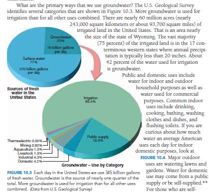
2 TABLE 10.1 Distribution of fresh water in the Hydrosphere Fresh Water of the Hydrosphere Parts of the Hydrosphere Volume of Fresh Water (km3) Share of Total Volume of Fresh Water (percent) Share of Total Volume of Liquid Fresh Water (percent) Ice sheets and glaciers 24,000,000 84,945 0 Groundwater 4,000,000 14, Lakes and reservoirs 155, Soil moisture 83, Water vapor in the 14, atmosphere River water 1, Total 28,253, The dissolving action of groundwater slowly removes rock, allowing surface depressions known as sinkholes to form as well as creating subterranean caverns. Groundwater is also an equalizer of stream flow. Much of the water that flows in rivers is not direct runoff from rain and snowmelt. Rather, a large percentage of precipitation soaks in and then moves slowly underground to stream channels. Groundwater is thus a form of storage that sustains streams during periods when rain does not fall. When we see water flowing in a river during a dry period, it is water from rain that fell at some earlier time and was stored underground. Groundwater A Basic Resource Water is basic to life. It has been called the bloodstream of both the biosphere and society. Each day in the United States we use about 349 billion gallons of fresh water.* About 77 percent comes from surface sources. Groundwater provides the remaining 23 percent. One of the advantages of groundwater is that it exists almost everywhere across the country and, thus, is often available in places that lack reliable surface sources such as lakes and rivers. Water in a groundwater system is stored in subsurface pore spaces and fractures. As water is withdrawn from a well, the connected pore spaces and fractures act as a pipeline that allows water to gradually move from one part of the hydrologic system to where it is being withdrawn. Although people have been digging and drilling wells for thousands of years, extensive use of groundwater is a relatively recent phenomenon growing rapidly with the development of rural electrification and more effective pumping technologies during the past 80 years. The 79 billion gallons of groundwater withdrawn each day in the United States represents only about 8 percent of the estimated 1 trillion
3 gallons per day of natural replenishment (termed recharge). Therefore, our groundwater resource appears to be ample. However, this is misleading because groundwater availability varies widely. For example, in the dry western states, groundwater demand is great, but rainfall to replenish the supply is often scarce. What are the primary ways that we use groundwater? The U.S. Geological Survey identifies several categories that are shown in Figure More groundwater is used for irrigation than for all other uses combined. There are nearly 60 million acres (nearly square kilometers or about 93,700 square miles) of irrigated land in the United States. That is an area nearly the size of the state of Wyoming. The vast majority (75 percent) of the irrigated land is in the 17 western states where annual precipitation is typically less than 20 inches. About 42 percent of the water used for irrigation is groundwater.
4

5 Public and domestic uses include water for indoor and outdoor household purposes as well as water used for commercial purposes. Common indoor uses include drinking, cooking, bathing, washing clothes and dishes, and flushing toilets. If you are curious about how much water an average American uses each day for indoor domestic purposes, look at FIGURE Major outdoor uses are watering grasses and gardens. Water for domestic use may come from a public supply or be self-supplied. For those who are self supplied, practically all (98 percent) rely on groundwater. Another category, aquaculture, involves water used for fish hatcheries, fish farms, and shellfish farms. Many mining operations require significant quantities of water, as do industrial processes that include petroleum refining and the manufacture of chemicals, plastics, paper, steel, and concrete. Distribution of Groundwater
6 When rain falls, some of the water runs off, some returns to the atmosphere by evaporation and transpiration, and the remainder soaks into the ground. This last path is the primary source of practically all subsurface water. The amount of water that takes each of these paths, however, varies greatly both in time and space. Influential factors include steepness of slope, nature of surface material, intensity of rainfall, and type and amount of vegetation. Heavy rains falling on steep slopes underlain by impervious materials will obviously result in a high percentage of the water running off. Conversely, if rain falls steadily and gently on more gradual slopes composed of materials that are easily penetrated by the water, a much larger percentage of water soaks into the ground. Groundwater pumping to support rapid population growth in south- central Arizona (including the Tucson and Phoenix areas) has resulted in water level declines (drawdown) of between 90 and 150 m (300 and 500 feet) Some of the water that soaks in does not travel far, because it is held by molecular attraction as a surface film on soil particles. This near- surface zone is called the zone of soil moisture. It is overlapped by roots, voids left by decayed roots, and animal and worm burrows that enhance the infiltration of rainwater into the soil. Soil water is used by plants in life functions and transpiration. Some water also evaporates directly back into the atmosphere. Water that is not held as soil moisture will percolate downward until it reaches a zone where all of the open spaces in sediment and rock are completely filled with water. This is the zone of saturation. Water within it is called groundwater. The upper limit of this zone is known as the water table. The area above the water table where the soil, sediment, and rock are not saturated is called the unsaturated zone (FIGURE 10.5). The pore spaces in this zone contain both air and water. Although a considerable amount of water can be present in the unsaturated zone, this water cannot be pumped by wells because it clings too tightly to rock and soil particles. By contrast, below the water table, the water pressure is great enough to allow water to enter wells, thus permitting groundwater to be withdrawn for use. We will examine wells more closely later in the chapter. The Water Table Importance and Distribution of Groundwater The water table, the upper limit of the zone of saturation, is a very significant feature of the groundwater system. The water-table level is important in predicting the productivity of wells, explaining the changes in the flow of springs and streams, and accounting for fluctuations in the levels of lakes. Variations in the Water Table
7 The depth of the water table is highly variable and can range from zero, when it is at the surface, to hundreds of meters in some places. An important characteristic of the water table is that its configuration varies seasonally and from year to year because the addition of water to the groundwater system is closely related to the quantity, distribution, and timing of precipitation. Except where the water table is at the surface, we cannot observe it directly. Nevertheless, its elevation can be mapped and studied in detail where wells are numerous, because the water level in wells coincides with the water table ). Such maps reveal that the water table is rarely level, as we might expect a table to be. Instead, its shape is usually a subdued replica of the surface topography, reaching its highest elevations beneath hills and then descending toward valleys. Where a wetland (swamp) is encountered, the water table is right at the surface. Lakes and streams generally occupy areas low enough that the water table is above the land surface. Several factors contribute to the irregular surface of the water table. One important influence is the fact that groundwater moves very slowly and at varying rates under different conditions. Because of this, water tends to pile up beneath high areas between stream valleys. If rainfall were to cease completely, these water table hills would slowly subside and gradually approach the level of the valleys. However, new supplies of rainwater are usually added frequently enough to prevent this. Nevertheless, in times of extended drought, the water table may drop enough to dry up shallow wells. Other causes for the uneven water table are variations in rainfall and permeability from place to place. Interaction between Groundwater and Streams The interaction between the groundwater system and streams is a basic link in the hydrologic cycle. It can take place in one of three ways. streams may gain water from the inflow of groundwater through the streambed. Such streams are called gaining streams. For this to occur, the elevation of the water table must be higher than the level of the surface of the stream. Streams may lose water to the groundwater system by outflow through the streambed. The term losing stream is applied to this situation When this happens, the elevation of the water table is lower than the surface of the stream. The third possibility is a combination of the first two a stream gains in some sections and loses in others. Losing streams can be connected to the groundwater system by a continuous saturated zone, or they can be disconnected from the groundwater system by an unsaturated zone. Compare parts B and C in Figure When the stream is disconnected, the water table may have a discernible bulge beneath the stream if the rate of water movement through

8 the streambed and zone of aeration is greater than the rate of groundwater movement away from the bulge. In some settings, a stream might always be a gaining stream or always be a losing stream. However, in many situations flow direction can vary a great deal along a stream; some sections receive groundwater and other sections lose water to the groundwater system. Moreover, the direction of flow can change over a short time span as the result of storms adding water near the stream bank or when temporary flood peaks move down the channel. Groundwater contributes to streams in most geologic and climatic settings. Even where streams are primarily losing water to the groundwater system, certain sections may receive groundwater inflow during some seasons. In one study of 54 streams in all parts of the United States, the analysis indicated that 52 percent of the stream flow was contributed by groundwater. The groundwater contribution ranged from a low of 14 percent to a maximum of 90 percent. Groundwater is also a major source of water for lakes and wetlands. Factors Influencing the Storage and Movement of
9 Groundwater The nature of subsurface materials strongly influences the rate of groundwater movement and the amount of groundwater that can be stored. Two factors are especially important porosity and permeability. Porosity Water soaks into the ground because bedrock, sediment, and soil contain countless voids, or openings. These openings are similar to those of a sponge and are often called pore spaces. The quantity of groundwater that can be stored depends on the porosity of the material, which is the percentage of the total volume of rock or sediment that consists of pore spaces. Voids most often are spaces between sedimentary particles, but also common are joints, faults, cavities formed by the dissolving of soluble rocks such as limestone, and vesicles (voids left by gases escaping from lava). Variations in porosity can be great. Sediment is commonly quite porous, and open spaces may occupy 10 to 50 percent of the sediment s total volume. Pore space depends on the size and shape of the grains, how they are packed together, the degree of sorting, and in sedimentary rocks, the amount of cementing material. For example, clay may have a porosity as high as 50 percent, whereas some gravels may have only 20 percent voids. Where sediments are poorly sorted, the porosity is reduced because the finer particles tend to fill the openings among the larger grains (see Most igneous and metamorphic rocks, as well as some sedimentary rocks, are composed of tightly interlocking crystals, so the voids between the grains may be negligible. In these rocks, fractures must provide the voids. Permeability, Aquitards, and Aquifers Porosity alone cannot measure a material s capacity to yield groundwater. Rock or sediment might be very porous yet still not allow water to move through it. The pores must be connected to allow water flow, and they must be large enough to allow flow. Thus, the permeability of a material, its ability to transmit a fluid, is also very important. Groundwater moves by twisting and turning through interconnected small openings. The smaller the pore spaces, the slower the water moves. For example, clay s ability to store water can be great, owing to its high porosity, but its pore spaces are so small that water is unable to move through it. Thus, clay s porosity is high but its permeability is poor. Impermeable layers that hinder or prevent water movement are termed aquitards. Clay is a good example. In contrast, larger particles, such as sand or gravel, have larger pore spaces. Therefore, the water moves with relative ease. Permeable rock strata or sediments that transmit groundwater freely are called aquifers. Sands and gravels are common examples.
10 In summary, you have seen that porosity is not always a reliable guide to the amount of groundwater that can be produced, and permeability is significant in determining the rate of groundwater movement and the quantity of water that might be pumped from a well. How Groundwater Moves The movement of water in the atmosphere and on the land surface is relatively easy to visualize, but the movement of groundwater is not. Near the beginning of the chapter we mentioned the common misconception that groundwater occurs in underground rivers that resemble surface streams. Although subsurface streams do exist, they are not common. Rather, as you learned in the preceding sections, groundwater exists in the pore spaces and fractures in rock and sediment. Thus, contrary to any impressions of rapid flow that an underground river might evoke, the movement of most groundwater is exceedingly slow, from pore to pore. By exceedingly slow, we mean anywhere from millimeters per year to perhaps a kilometer per year, depending on conditions A Simple Groundwater Flow System FIGURE 10.8 depicts a simple example of a groundwater flow system a three dimensional body of Earth material saturated with moving groundwater. It shows groundwater moving along flow paths from areas of recharge to a zone of discharge along a stream. Discharge also occurs at springs, lakes, or wetlands, as well as in coastal areas as seeps into bays or the ocean. Transpiration by plants whose roots extend to near the water table represents another form of groundwater discharge. The energy that makes groundwater move is provided by the force of gravity. In response to gravity, water moves from areas where the water table is high to zones where the water table is lower. Although some water takes the most direct path down the slope of the water table, much of the water follows long, curving paths toward the zone of discharge. Figure 10.8 shows water percolating into a stream from all possible directions. Some paths clearly turn upward, apparently against the force of gravity, and enter through the bottom of the channel. This is easily explained: The deeper you go into the zone of saturation, the greater the water pressure. Thus, the looping curves followed by water in the saturated zone may be thought of as a compromise between the downward pull of gravity and the tendency of water to move toward areas of reduced pressure. As a result, water at any given height is under greater pressure beneath a hill than beneath a stream channel, and the water tends to migrate toward points of lower pressure. Measuring Groundwater Movement:

11 The foundations of our modern understanding of groundwater movement began in the mid-19th century with the work of the French scientistengineer Henri Darcy. Among the experiments carried out by Darcy was one that showed that the velocity of groundwater flow is proportional to the slope of the water table the steeper the slope, the faster the water moves (because the steeper the slope, the greater the pressure difference between two points). The water-table slope is known as the hydraulic gradient and can be expressed as follows: where h1 is the elevation of one point on the water table, h2 is the elevation of a second point, and d is the horizontal distance between the two points (FIGURE 10.9). hydraulic gradient = (h1 - h2)/d Darcy also discovered that the flow velocity varied with the permeability of the sediment groundwater flows more rapidly through sediments having greater permeability than through materials having lower permeability. This factor is known as hydraulic conductivity and is a coefficient that takes into account the permeability of the aquifer and the viscosity of the fluid. To determine discharge (Q) that is, the actual volume of water that flows through an aquifer in a specified time the following equation is used: where is the hydraulic gradient, K is the coefficient that represents hydraulic conductivity, and A is the cross-sectional area of the aquifer. This expression has come to be called Darcy s law. Perrault computed the quantity of water that fell on France s Seine River basin. He then calculated the mean annual runoff by measuring the river s discharge. After allowing for the loss of water by evaporation, he showed that there was sufficient water remaining to feed the springs. Thanks to Perrault s pioneering efforts
12 and the measurements by many afterward, we now know that the source of springs is water from the zone of saturation and that the ultimate source of this water is precipitation. Whenever the water table intersects Earth s surface, a natural outflow of groundwater results, which we call a spring. Springs such as the one pictured in FIGURE form when an aquitard blocks the downward movement of groundwater and forces it to move laterally. Where the permeable bed outcrops, a spring results. Another situation leading to the formation of a spring is illustrated in Figure Here an aquitard is situated above the main water table. As water percolates downward, a portion of it is intercepted by the aquitard, thereby creating a localized zone of saturation called a perched water table. Springs, however, are not confined to places where a perched water table creates a flow at the surface. Many geological situations lead to the formation of springs because subsurface conditions vary greatly from place to place. Even in areas underlain by impermeable crystalline rocks, permeable zones may exist in the form of fractures or solution channels. If these openings fill with water and intersect the ground surface along a slope, a spring will result. 1 Wells --Groundwater Springs and Wells The most common device used by people for removing groundwater is the well, a hole bored into the zone of saturation (FIGURE 10.11). Wells serve as small reservoirs into which groundwater migrates and from which it can be pumped to the surface. The use of wells dates back many centuries and continues to be an important method of obtaining water today The watertable level may fluctuate considerably during the course of a year, dropping during dry seasons and rising following periods of rain. Therefore, to ensure a continuous supply of water, a well must penetrate below the water table. Often when water is withdrawn from a well, the water table around the well is lowered. This effect, termed drawdown, decreases with increasing distance from the well. The result is a depression in the water table, roughly conical in shape, known as a cone of depression. Because the cone of depression increases the slope of the water table near the well, groundwater will flow more rapidly toward the opening. For most small domestic wells, the cone of depression is negligible. However, when wells are heavily pumped for irrigation or industrial purposes, the withdrawal of water can be great enough to create a very wide and steep cone of depression. This may substantially lower the water table in an area and cause nearby shallow wells to become high and dry. Figure also illustrates this situation. Digging a successful well is a familiar problem for people in areas where groundwater is the primary source of supply. One well may be successful
13 at a depth of 10 meters (33 feet), whereas a neighbor may have to go twice as deep to find an adequate supply. Still others may be forced to go deeper or try a different site altogether. When subsurface materials are heterogeneous, the amount of water a well is capable of providing may vary a great deal over short distances. For example, when two nearby wells are drilled to the same level and only one is successful, it may be caused by the presence of a perched water table beneath one of them. Such a case is shown in Figure Massive igneous and metamorphic rocks provide a second example. These crystalline rocks are usually not very permeable except where they are cut by many intersecting joints and fractures. Therefore, when a well drilled into such rock does not intersect an adequate network of fractures, it is likely to be unproductive. Artesian Wells Groundwater Springs and Wells In most wells, water cannot rise on its own If water is first encountered at 30 meters depth, it remains at that level, fluctuating perhaps a meter or two with seasonal wet and dry periods. However, in some wells, water rises, sometimes overflowing at the surface. Such wells are abundant in the Artois region of northern France, and so we call these self-rising wells artesian. The term artesian is applied to any situation in which groundwater rises in a well above the level where it was initially encountered. For such a situation to occur, two conditions usually exist: (1) Water is confined to an aquifer that is inclined so that one end is exposed at the surface, where it can receive water; and (2) aquitards, both above and below the aquifer, must be present to prevent the water from escaping. Such an aquifer is called a confined aquifer. When such a layer is tapped, the pressure created by the weight of the water above will force the water to rise. If there were no friction, the water in the well would rise to the level of the water at the top of the aquifer. However, friction reduces the height of this pressure surface. The greater the distance from the recharge area (area where water enters the inclined aquifer), the greater the friction and the less the rise of water. In Figure 10.12, Well 1 is a nonflowing artesian well, because at this location the pressure surface is below ground level. When the pressure surface is above the ground and a well is drilled into the aquifer, a flowing artesian well is created (Well 2). Not all artesian systems are wells Artesian springs also exist. Here groundwater may reach the surface by rising along a natural fracture such as a fault rather than through an artificially produced hole. In deserts, artesian springs are sometimes responsible for creating an oasis. Artesian systems act as conduits, transmitting water from remote areas of recharge great distances to the points of discharge. In this manner, water
14 that fell in central Wisconsin years ago is now taken from the ground and used by communities many kilometers away in Illinois. In South Dakota, such a system brings water from the Black Hills in the west eastward across the state On a different scale, city water systems can be considered to be examples of artificial artesian systems. The water tower, into which water is pumped, can be considered the area of recharge; the pipes the confined aquifer; and the faucets in homes the flowing artesian wells. Environmental Problems Associated with Groundwater: As with many of our valuable natural resources, groundwater is being exploited at an increasing rate. In some areas, overuse threatens the groundwater supply. In other places, groundwater withdrawal has caused the ground and everything resting upon it to sink. Still other localities are concerned with the possible contamination of their groundwater supply. Treating Groundwater as a Nonrenewable Resource. Many natural systems tend to establish a condition of equilibrium. The groundwater system is no exception. The water table s height reflects a balance between the rate of water added by precipitation and the rate of water removed by discharge and withdrawal. Any imbalance will either raise or lower the water table. A long-term drop in the water table can occur if there is either a decrease in recharge due to a prolonged drought or an increase in groundwater discharge or withdrawal. For many, groundwater appears to be an endlessly renewable resource because it is continually replenished by rainfall and melting snow. But in some regions groundwater has been and continues to be treated as a nonrenewable resource. Where this occurs, the water available to recharge the aquifer falls significantly short of the amount being withdrawn. The High Plains aquifer provides one example. Underlying about 111 million acres (450,000 square kilometers or 174,000 square miles) in parts of eight western states, it is one of the largest and most agriculturally significant aquifers in the United States. It accounts for about 30 percent of all groundwater withdrawn for irrigation in the country. Mean annual precipitation is modest ranging from about 40 centimeters (16 inches) in western portions to about 71 centimeters (28 inches) in eastern parts. Evaporation rates, on the other hand, are high ranging from about 150 centimeters (60 inches) per year in the cooler northern parts of the region to 265 centimeters (105 inches) per year in the warmer southern parts. Because evaporation rates are high relative to precipitation, there is little rainwater to recharge the aquifer. Thus, in some parts of the region, where intense irrigation has been practiced for an extended period, depletion of groundwater has been severe. Groundwater depletion has been a concern
15 in the High Plains and other areas of the West for many years, but it is worth pointing out that the problem is not confined to this part of the country. Increased demands on groundwater resources have overstressed aquifers in many areas, not just in arid and semiarid regions. Land subsidence due to groundwater withdrawal began in the valley in the mid-1920s and locally exceeded 8 meters (28 feet) by Then, because of the importation of surface water and a decrease in groundwater pumping, water levels in the aquifer recovered and subsidence ceased. However, during a drought from 1976 to 1977, heavy groundwater pumping led to renewed subsidence. This time, water levels dropped at a much faster rate than during the previous period because of the reduced storage capacity caused by earlier compaction of material in the aquifer. In all, more than 13,400 square kilometers (5200 square miles) of irrigable land, half the entire valley, were affected by subsidence. Damage to structures, including highways, bridges, water lines, and wells, was extensive. Many other cases of land subsidence due to groundwater pumping exist in the United States, including cases in Las Vegas, Nevada; New Orleans and Baton Rouge, Louisiana; portions of Southern Arizona; and the Houston Galveston area of Texas. In the low-lying coastal area between Houston and Galveston, land subsidence ranges from 1.5 to 3 meters (5 to 9 feet). The result is that about 78 square kilometers (30 square miles) are permanently flooded. Outside the United States, one of the most spectacular examples of subsidence occurred in Mexico City, which is built on a former lake bed. In the first half of the 20th century, thousands of wells were sunk into the water-saturated sediments beneath the city. As water was withdrawn, portions of the city subsided by as much as 6 to 7 meters. In some places buildings have sunk to such a point that access to them from the street is located at what used to be the second-floor level! Groundwater Contamination The pollution of groundwater is a serious matter, particularly in areas where aquifers provide a large part of the water supply. One common source of groundwater pollution is sewage. Its sources include an everincreasing number of septic tanks, as well as inadequate or broken sewer systems and farm waste. If sewage water that is contaminated with bacteria enters the groundwater system, it may become purified through natural processes. The harmful bacteria may be mechanically filtered by the sediment through which the water percolates, destroyed by chemical oxidation, and/or assimilated by other organisms. For purification to occur, however, the aquifer must be of the correct composition. For example, extremely permeable aquifers (such as highly fractured crystalline rock, coarse gravel, or cavernous limestone)
16 have such large openings that contaminated groundwater might travel long distances without being cleansed. In this case, the water flows too rapidly and is not in contact with the surrounding material long enough for purification to occur. This is the problem at Well 1 in FIGURE In contrast, when the aquifer is composed of sand or permeable sandstone, the water can sometimes be purified after traveling only a few dozen meters through it. The openings between sand grains are large enough to permit water movement, yet the movement of the water is slow enough to allow ample time for its purification (Well 2, Figure 10.16). Other sources and types of contamination also threaten groundwater supplies. These include widely used substances such as highway salt, fertilizers that are spread across the land surface, and pesticides (FIGURE 10.17). In addition, a wide array of chemicals and industrial materials may leak from pipelines, storage tanks, landfills, and holding ponds. Some of these pollutants are classified as hazardous, meaning that they are flammable, corrosive, explosive, or toxic. As rainwater oozes through the refuse, it may dissolve a variety of potential contaminants. If the leached material reaches the water table, it will mix with the groundwater and contaminate the supply. Similar problems may result from leakage of shallow excavations called holding ponds into which various liquid wastes are disposed. Because groundwater movement is usually slow, polluted water may go undetected for a long time. In fact, contamination is sometimes discovered only after drinking water has been affected and people become ill. By this time, the volume of polluted water may be very large, and even if the source of contamination is removed immediately, the problem is not solved. Although the sources of groundwater contamination are numerous, there are relatively few solutions. Once the source of the problem has been identified and eliminated, the most common practice is simply to abandon the water supply and allow the pollutants to be flushed away gradually. This is the least costly and easiest solution, but the aquifer must remain unused for many years. To accelerate this process, polluted water is sometimes pumped out and treated. Following removal of the tainted water, the aquifer is allowed to recharge naturally, or in some cases the treated water or other fresh water is pumped back in. This process is costly, time-consuming, and possibly risky because there is no way to be certain that all of the contamination has been removed. Clearly, the most effective solution to groundwater contamination is prevention. Hot Springs and Geysers By definition, the water in hot springs is 6 to 9 C (11 to 16 F) warmer than the mean annual air temperature for the localities where they occur.
17 In the United States alone, there are well over 1000 such springs. Temperatures in deep mines and oil wells usually rise with increasing depth, an average of about 2 C per 100 meters (1 F per 100 feet). Therefore, when groundwater circulates at great depths, it becomes heated. If it rises to the surface, the water may emerge as a hot spring. The water of some hot springs in the eastern United States is heated in this manner. The great majority (over 95 percent) of the hot springs (and geysers) in the United States are found in the West. The reason for such a distribution is that the source of heat for most hot springs is cooling igneous rock, and it is in the West that igneous activity has occurred most recently. Geysers are intermittent hot springs or fountains where columns of water are ejected with great force at various intervals, often rising 30 to 60 meters (100 to 200 feet) into the air (FIGURE 10.18). After the jet of water ceases, a column of steam rushes out, usually with a thunderous roar. Perhaps the most famous geyser in the diversity, and spectacular nature of Yellowstone s geysers and other thermal features undoubtedly were the primary reason for its becoming the first national park in the United States. Geysers are also found in other parts of the world, notably New Zealand and Iceland. In fact, the Icelandic word geysa, to gush, gives us the name geyser. Geysers: occur where extensive underground chambers exist within hot igneous rocks. How they operate is shown in FIGURE As relatively cool groundwater enters the chambers, it is heated by the surrounding rock. At the bottom of the chambers, the water is under great pressure because of the weight of the overlying water. This great pressure prevents the water from boiling at the normal surface temperature of 100 C (212 F). For example, water at the bottom of a 300-meter (1000- foot) water-filled chamber must reach nearly 230 C (450 F) to boil. The heating causes the water to expand, with the result that some is forced out at the surface. This loss of water reduces the pressure on the remaining water in the chamber, which lowers the boiling point. A portion of the water deep within the chamber quickly turns to steam, and the geyser erupts. Following the eruption, cool groundwater again seeps into the chamber, and the cycle begins anew. When groundwater from hot springs and geysers flows out at the surface, material in solution is often precipitated, producing an accumulation of chemical sedimentary rock. The material deposited at any given place commonly reflects the chemical make-up of the rock through which the water circulated. When the water contains dissolved silica, a material called siliceous sinter or geyserite is deposited around the spring. When the water contains dissolved calcium carbonate, a form of limestone called travertine or calcareous tufa is deposited. The latter term is used if the material is spongy and porous The deposits at Mammoth Hot Springs in Yellowstone National Park are more
18 spectacular than most. As the hot water flows upward through a series of channels and then out at the surface, the reduced pressure allows carbon dioxide to separate and escape from the water. The loss of carbon dioxide causes the water to become supersaturated with calcium carbonate, which then precipitates. In addition to containing dissolved silica and calcium carbonate, some hot springs contain sulfur, which gives water a poor taste and unpleasant odor. Undoubtedly, Rotten Egg Spring, Nevada, is such a situation. Geothermal Energy Geothermal energy is harnessed by tapping natural underground reservoirs of steam and hot water. These occur where subsurface temperatures are high, owing to relatively recent volcanic activity. Geothermal energy is put to use in two ways: The steam and hot water are used for heating and to generate electricity. Iceland is a large volcanic island with many active volcanoes (FIGURE 10.21). In Iceland s capital, Reykjavik, hot water is pumped into buildings throughout the city for space heating. (Reykjavik literally means bay of steam. ) It also warms greenhouses, where fruits and vegetables are grown year-round. In the United States, localities in several western states use hot water from geothermal sources for space heating. As for generating electricity geothermally, the Italians were the first to do so in 1904, so the idea is not new. In 2009 more than 250 geothermal power plants in 24 countries were producing more than 10,000 megawatts (million watts). These plants provide power to more than 60 million people. The leading producers of geothermal power are listed in TABLE The first commercial geothermal power plant in the United States was built in 1960 at The Geysers, north of San Francisco. The Geysers remains the world s largest geothermal power plant, generating nearly 1000 megawatts. In addition to The Geysers, geothermal development is occurring elsewhere in the western United States, including Nevada, Utah, and the Imperial Valley in southern California. What geologic factors favor a geothermal reservoir of commercial value? TABLE 10.2 Table TProducing Country Megawatts United States 2687 Philippines 1970 Indonesia 992 Mexico 953 Italy 810 Japan 535 New Zealand 472 Iceland 421
19 El Salvador 204 Costa Rica 163 All others 525 Total Effective source of heat such as a large magma chamber deep enough to ensure adequate pressure and slow cooling yet not so deep that the natural water circulation is inhibited. Such magma chambers are most likely in regions of recent volcanic activity. 2. Large and porous reservoirs with channels connected to the heat source, near which water can circulate and then be stored in the reservoir. 3. A cap of low permeability rocks that inhibits the flow of water and heat to the surface. A deep, well-insulated reservoir contains much more stored energy than does a similar but uninsulated reservoir. As with other alternative methods of power production, geothermal sources are not expected to provide a high percentage of the world s growing energy needs. Nevertheless, in regions where its potential can be developed, its use will continue to grow. Land Subsidence Caused by Groundwater Withdrawal As you will see later in this chapter, surface subsidence can result from natural processes related to groundwater. However, the ground may also sink when water is pumped from wells faster than natural recharge processes can replace it. This effect is particularly pronounced in areas underlain by thick layers of loose sediment. As water is withdrawn, the weight of the overburden packs the sediment grains more tightly together and the ground subsides. Many areas can be used to illustrate such land subsidence caused by excessive pumping of groundwater from relatively loose sediment. The Geologic Work of Groundwater Groundwater dissolves rock. This fact is the key to understanding how caverns and sinkholes form. Because soluble rocks, especially limestone, underlie millions of square kilometers of Earth s surface, it is here that groundwater carries on its important role as an erosional agent. Limestone is nearly insoluble in pure water, but it is quite easily dissolved by water containing small quantities of carbonic acid, and most groundwater contains this acid. It forms because rainwater readily dissolves carbon dioxide from the air and from decaying plants. Therefore, when
20 groundwater comes in contact with limestone, the carbonic acid reacts with calcite (calcium carbonate) in the rocks to form calcium bicarbonate, a soluble material that is then carried away in solution. Caverns The most spectacular results of groundwater s erosional handiwork are limestone caverns. In the United States alone, about 17,000 caves have been discovered, and new ones are being found every year. Although most are modest, some have spectacular dimensions. Mammoth Cave in Kentucky and Carlsbad Caverns in southeastern New Mexico are two famous examples that are both national parks. The Mammoth Cave system is the most extensive in the world, with more than 557 kilometers (345 miles) of interconnected passages. The dimensions at Carlsbad Caverns are impressive in a different way. Here we find the largest and perhaps most spectacular single chamber. The Big Room at Carlsbad Caverns has an area equivalent to 14 football fields and enough height to accommodate the U.S. Capitol Building. Most caverns are created at or just below the water table in the zone of saturation. Here acidic groundwater follows lines of weakness in the rock, such as joints and bedding planes. As time passes, the dissolving process slowly creates cavities and gradually enlarges them into caverns. The material dissolved by groundwater is carried away and discharged into streams and transported to the ocean. In many caves, development has occurred at several levels, with the current cavern-forming activity occurring at the lowest elevation. This situation reflects the close relationship between the formation of major subterranean passages and the river valleys into which they drain. As streams cut their valleys deeper, the water table drops as the elevation of the river drops. Consequently, during periods when surface streams are rapidly eroding downward, surrounding groundwater levels drop rapidly and cave passages are abandoned by the water table while the passages are still relatively small in cross-sectional area. Conversely, when the entrenchment of streams is slow or negligible, there is time for large passages to form. Certainly the features that arouse the greatest curiosity for most cavern visitors are the stone formations that give some caverns a wonderland appearance. These are not erosional features like the cavern itself, but are depositional features created by the seemingly endless dripping of water over great spans of time. The calcium carbonate that is left behind produces the limestone we call travertine. These cave deposits, however, are also commonly called dripstone, an obvious reference to their mode of origin. Although the formation of caverns takes place in the zone of saturation, the deposition of dripstone is not possible until the caverns are above the water table in the unsaturated zone. As soon as the chamber is filled with air, the stage is set for the decoration phase of cavern building to begin. The various dripstone features found in caverns
21 are collectively called speleothems (a structure formed in a cave by the deposition of minerals from water), no two of which are exactly alike (FIGURE 10.23). Perhaps the most familiar speleothems are stalactites. These icicle-like pendants hang from the ceiling of the cavern and form where water seeps through cracks above. When the water reaches the air in the cave, some of the carbon dioxide in solution escapes from the drop and calcium carbonate precipitates. Deposition occurs as a ring around the edge of the water drop. As drop after drop follows, each leaves an infinitesimal trace of calcite behind, and a hollow limestone tube is created. Water then moves through the tube, remains suspended momentarily at the end, contributes a tiny ring of calcite, and falls to the cavern floor. The stalactite just described is appropriately called a soda straw (Figure 10.23A). Often the hollow tube of the soda straw becomes plugged or its supply of water increases. In either case, the water is forced to flow, and hence deposit, along the outside of the tube. As deposition continues, the stalactite takes on the more common conical shape. Speleothems that form on the floor of a cavern and reach upward toward the ceiling are called stalagmites. The water supplying the calcite for stalagmite growth falls from the ceiling and splatters over the surface. As a result, stalagmites do not have a central tube, and they are usually more massive in appearance and more rounded on their upper ends than stalactites. Given enough time, a downward-growing stalactite and an upward-growing stalagmite may join to form a column By contrast, sinkholes can also form abruptly and without warning when the roof of a cavern collapses under its own weight. Typically, the depressions created in this manner are steep-sided and deep. When they form in populous areas, they may represent a serious geologic hazard. In addition to a surface pockmarked by sinkholes, karst regions characteristically show a striking lack of surface drainage (streams). Following a rainfall, the runoff is quickly funneled below ground through the sinks. It then flows through caverns until it finally reaches the water table. Where streams do exist at the surface, their paths are usually short. The names of such streams often give a clue to their fate. In the Mammoth Cave area of Kentucky, for example, there is Sinking Creek, Little Sinking Creek, and Sinking Branch. Other sinkholes become plugged with clay and debris to create small lakes or ponds. Some regions of karst development exhibit landscapes that look very different from the sinkhole-studded terrain depicted in Figure One striking example is an extensive region in southern China that is described as exhibiting tower karst. This area is pictured in the chapter-opening photo (p. 238). The term tower is appropriate because the landscape consists of a maze of isolated steep-sided hills that rise abruptly karst topography forms in wet tropical and subtropical regions having thick beds of highly jointed
22 limestone. Here groundwater has dissolved large volumes of limestone, leaving only these residual towers. Karst development is more rapid in tropical climates due to the abundant rainfall and the greater availability of carbon dioxide from the decay of lush tropical vegetation. The extra carbon dioxide in the soil means there is more carbonic acid for dissolving limestone. Other tropical areas of advanced karst development include portions of Puerto Rico, western Cuba, and northern Vietnam. Karst Topography Many areas of the world have landscapes that to a large extent have been shaped by the dissolving power of groundwater. Such areas are said to exhibit karst topography, named for the Krs Plateau, located along the northeastern shore of the Adriatic Sea in the border area between Slovenia and Italy where such topography is strikingly developed. In the United States, karst landscapes occur in many areas that are underlain by limestone, including portions of Kentucky, Tennessee, Alabama, southern Indiana, and central and northern Florida (FIGURE 10.24). Generally, arid and semiarid areas are too dry to develop karst topography. When solution features exist in such regions, they are likely to be remnants of a time when rainier conditions prevailed. Karst areas typically have irregular terrain punctuated with many depressions, called sinkholes or sinks (FIGURE 10.25). In the limestone areas of Florida, Kentucky, and southern Indiana, there are literally tens of thousands of these depressions varying in depth from just a meter or two to a maximum of more than 50 meters. Sinkholes commonly form in two ways. Some develop gradually over many years without any physical disturbance to the rock. In these situations, the limestone immediately below the soil is dissolved by downward-seeping rainwater that is freshly charged with carbon dioxide. With time, the bedrock surface is lowered and the fractures into which the water seeps are enlarged. As the fractures grow in size, soil subsides into the widening voids, from which it is removed by groundwater flowing in the passages below. These depressions are usually shallow and have gentle slopes. C H A P T E R T E N Groundwater in Review As a resource, groundwater represents the largest reservoir of fresh water that is readily available to humans. Geologically, the dissolving action of groundwater produces caves and sinkholes. Groundwater is also an equalizer of stream flow.
CHAPTER 13 OUTLINE The Hydrologic Cycle and Groundwater. Hydrologic cycle. Hydrologic cycle cont.
 CHAPTER 13 OUTLINE The Hydrologic Cycle and Groundwater Does not contain complete lecture notes. To be used to help organize lecture notes and home/test studies. Hydrologic cycle The hydrologic cycle is
Groundwater Earth 9th Edition Chapter 17 Mass wasting: summary in haiku form Importance of groundwater Importance of groundwater
 1 2 3 4 5 6 7 8 9 10 11 Groundwater Earth 9 th Edition Chapter 17 Geology 100 Mass wasting: summary in haiku form The grass is greener over the septic system said Erma Bombeck. Importance of groundwater
7/3/2018. Groundwater
 1 2 3 4 5 6 7 8 9 10 11 12 Groundwater Earth Chapter 17 Chapter 17 Groundwater Importance of Groundwater Groundwater is water found in the pores of soil and sediment, plus narrow fractures in bedrock Groundwater
Groundwater. Chapter 10 11/22/2011. I. Importance of groundwater
 Groundwater Chapter 10 I. Importance of groundwater A. Groundwater is water found in the pores of soil and sediment, plus narrow fractures in bedrock B. Where is fresh water - 2 % of all water is fresh
Wells To ensure a continuous supply of water, a well must penetrate below the water table. Pumping of wells can cause:
 Wells To ensure a continuous supply of water, a well must penetrate below the water table. Pumping of wells can cause: Drawdown (lowering) of the water table Cone of depression in the water table Cone
global distribution of water!
 groundwater! hydrologic cycle! 2 global distribution of water! Source Volume Percent Ocean 97.2000 Glaciers and other ice 2.1500 Ground Water 0.6100 Lakes fresh 0.0090 saline 0.0080 Soil Moisture 0.0050
The Hydrologic Cycle (with emphasis on groundwater)
") The Hydrologic Cycle (with emphasis on groundwater) The Hydrologic Cycle (viewed in series of steps) 1. Water evaporates from bodies of surface water and from land 2. As moist air is lifted, it cools and
The Hydrologic Cycle (with emphasis on groundwater) The Hydrologic Cycle (viewed in series of steps) 1. Water evaporates from bodies of surface water and from land 2. As moist air is lifted, it cools and
Groundwater. Importance of Groundwater. The Water Table. Geol 104: Groundwater
 Groundwater Subsurface water contained in soil and bedrock. There is ~ 60 times as much water underground than in freshwater streams and lakes. Source of groundwater is rain and snow. Represents the infiltration
General Groundwater Concepts
 General Groundwater Concepts Hydrologic Cycle All water on the surface of the earth and underground are part of the hydrologic cycle (Figure 1), driven by natural processes that constantly transform water
Ground Water Chapter 11
 Ground Water Chapter 11 How does water get underground? How is water stored underground? How does water move? How do we find it? Why we need to protect it. Lake Powell. Water levels are decreasing every
Movement and Storage of Groundwater The Hydrosphere
 Movement and Storage of Groundwater The Hydrosphere The water on and in Earth s crust makes up the hydrosphere. About 97 percent of the hydrosphere is contained in the oceans. The water contained by landmasses
FACT FLASH. 5: Groundwater. What is groundwater? How does the ground store water? Fact Flash 5: Groundwater
 FACT FLASH 5: Groundwater What is groundwater? Groundwater is fresh water (from rain or melting ice and snow) that soaks into the soil and is stored in the tiny spaces (pores) between rocks and particles
GLY 155 Introduction to Physical Geology, W. Altermann. Grotzinger Jordan. Understanding Earth. Sixth Edition
 Grotzinger Jordan Understanding Earth Sixth Edition Chapter 17: THE HYDROLOGIC CYCLE AND GROUNDWATER 2011 by W. H. Freeman and Company Chapter 17 The Hydrologic Cycle and Groundwater 1 About the Hydrologic
Water Cycle. Are you really drinking the same water as the caveman?
 Water Cycle Are you really drinking the same water as the caveman? Water Cycle Water is always on the move. Rain falling where you live may have been water in the ocean just days before. And the water
East Maui Watershed Partnership Adapted from Utah State University and University of Wisconsin Ground Water Project Ages 7 th -Adult
 INTRODUCTION What is groundwater? Water contained in saturated soil and rock materials below the surface of the earth. It is not NEW water, but is recycled water through the hydraulic cycle. The source
Hydrologic Cycle. Water Cycle. Groundwater
 Water Cycle, Groundwater, Water Pollution Hydrologic Cycle Distribution/Cycle Animation http://www.mnforsustain.org/water_climate_global_water_cycle_study.htm Water Cycle 86% of evaporation from sea surface
Understanding the Water System
 W Water Is a Natural Resource Understanding the Water System Cost WATER QUALITY in KENTUCKY The Water Cycle Figure 1. Trends in Water Withdrawals and Population, 1950 to 1995. Millions of People/Billion
groundwater. Because watersheds are complex systems, each tends to respond differently to natural or human activities.
 The private development of Altos del María is located at an altitude between 550 and 1,000 meters above sea level in the environmentally sensitive Cordillera Central of Panama that separates the Pacific
Water Resources. The Water Cycle. Section 1. Key Terms surface water river system watershed groundwater aquifer porosity permeability recharge zone
 Water Resources The next time you drink a glass of water, think about where the water came from. Did you know that some of the water in your glass may have been part of a rainstorm that pounded Earth long
Groundwater and surface water: a single resource. Santa Cruz River, Tucson
 Groundwater and surface water: a single resource Santa Cruz River, Tucson 1942 1989 1 Groundwater basics Groundwater is water found within the pore spaces of geologic material beneath the surface of the
Groundwater basics. Groundwater and surface water: a single resource. Pore Spaces. Simplified View
 Groundwater and surface water: a single resource Santa Cruz River, Tucson Groundwater basics Groundwater is water found within the pore spaces of geologic material beneath the surface of the Earth. It
True False Click and Drag Artesian wells are naturally under pressure and require no additional pumps to get the water out of the ground.
 True False Click and Drag Artesian wells are naturally under pressure and require no additional pumps to get the water out of the ground. Groundwater recharge is the water from infiltration Groundwater
Groundwater. Groundwater Movement. Groundwater Movement Recharge: the infiltration of water into any subsurface formation.
 On March 22, 2014, a major landslide occurred near Oso, Washington. Death toll currently at 30, with 15 still missing. Groundwater Before and After Swipe http://bit.ly/pen1jt N. Fork Stillaguamish River
Groundwater Flow Demonstration Model Activities for grades 4-12
 Groundwater Flow Demonstration Model Activities for grades 4-12 NR/WQ/2012-5 SET-UP Please allow time to practice using the groundwater model before conducting demonstrations. 1. Remove the groundwater
ENGINEERING HYDROLOGY
 ENGINEERING HYDROLOGY Prof. Rajesh Bhagat Asst. Professor Civil Engineering Department Yeshwantrao Chavan College Of Engineering Nagpur B. E. (Civil Engg.) M. Tech. (Enviro. Engg.) GCOE, Amravati VNIT,
Groundwater 3/16/2010. GG22A: GEOSPHERE & HYDROSPHERE Hydrology
 GG22A: GEOSPHERE & HYDROSPHERE Hydrology Definitions Groundwater Subsurface water in soil or rock that is fully saturated. Aquifer Contains enough saturated material to yield significant quantities of
The Hydrologic Cycle and Groundwater
 CHAPTER 17 The Hydrologic Cycle and Groundwater Chapter Summary The hydrologic cycle is a flowchart or model for the distribution and movements of water on and below the surface of the Earth. The major
Introduction to Groundwater
 Introduction to Groundwater Unit Essential Questions: How does the Earth cycle its water through its major reservoirs? How does society s use of resources affect water quality? Presentation Objectives:
Freshwater. 260 Points Total
 9 SURFACE WATER SECTION 9.1 Surface Water Movement In your textbook, read about surface water and the way in which it moves sediment. Complete each statement. (13 points) 1. An excessive amount of water
Analyzing Groundwater
 Analyzing Groundwater SUBJECTS: Science GRADE LEVELS: 7 th DURATION: approximately two 60 minute periods ACTIVITY SUMMARY: Students will compare the properties of different soil types including texture
Hydrologic Cycle. Rain Shadow:
 Hydrologic Cycle The cyclical movement of water from the ocean to the atmosphere by evaporation, to the surface through precipitation, to streams through runoff and groundwater, and back to the ocean.
RUNNING WATER AND GROUNDWATER
 NAME RUNNING WATER AND GROUNDWATER I. Introduction In this exercise we will investigate various features associated with streams and groundwater. Our drinking water ultimately comes from either streams
Overview. Students will...
 Overview Students will... Understand the interaction between ground water and surface water. Observe the difference between a permeable layer and an impermeable layer in an aquifer. See how water is stored
CHAPTER # 4. Fate of Pollutants in the Environment
 CHAPTER # 4 Fate of Pollutants in the Environment Once a pesticide is introduced into the environment, whether through an application, a disposal or a spill, it is influenced by many processes. These processes
OBJECTIVES BACKGROUND INFORMATION SUBJECTS: TIME: MATERIALS: The student will do the following: 1. Define groundwater.
 9-12 FROM GROUND TO WATER SUBJECTS: TIME: Language Arts, Science (Physical Science, Earth Science) 1 class period MATERIALS: Student Sheets: The Hidden Resource Groundwater. Keeping it Safe Keeping it
Introduction to Groundwater Science
 Introduction to Groundwater Science Laila Kasuri LUMS - WIT Overview Groundwater Hydrology and Basic Terms Groundwater Movement and Flow Groundwater Challenges Groundwater Management What is Groundwater
Timing Key Narrative Snapshots a) 00:44 How does groundwater recharge occur? How do streams form?
 00:44 How does groundwater recharge occur? How do streams form?") Module 4 Narration: Runoff and Recharge Timing Key Narrative Snapshots a) 00:44 How does groundwater recharge occur? How do streams form? These processes are closely linked. Lets first investigate how
Module 4 Narration: Runoff and Recharge Timing Key Narrative Snapshots a) 00:44 How does groundwater recharge occur? How do streams form? These processes are closely linked. Lets first investigate how
Why Care About Contaminants in Groundwater?
 Why Care About Contaminants in Groundwater? Subject/ target grade: Middle School (8 th grade) Earth Science Duration: Two 50 minute periods Setting: Classroom Materials and Equipment Needed: Per class
Water is a solid, liquid, & gas. 71% of earth s surface is water. Our body is two-thirds water. Fresh water water that is not salty and has little or
 Water is a solid, liquid, & gas. 71% of earth s surface is water. Our body is two-thirds water. Fresh water water that is not salty and has little or no taste, color, or smell. Salt water water that contains
GY 111 Lecture Note Series Groundwater and Hydrogeology
 GY 111 Lecture Notes D. Haywick (2008-09) 1 GY 111 Lecture Note Series Groundwater and Hydrogeology Lecture Goals A) The hydrologic cycle B) Groundwater dynamics C) Mapping groundwater (done in class not
The ground beneath your feet isn t as solid as you might think. It
 6.3 Water Beneath the Surface Section 6.3 1 FOCUS Key Concepts Where is groundwater and how does it move? How do springs form? What are some environmental threats to groundwater supplies? How and where
TEKS Lesson 7.8C: Effects of Human Activity on Surface Water and Groundwater
 Class ----- Date -------- TEKS Lesson 7.SC TEKS 7.8e Model the effects of human activity on groundwater surface water in a watershed. and TEKS Lesson 7.8C: Effects of Human Activity on Surface Water and
Loss Control TIPS Technical Information Paper Series
 Loss Control TIPS Technical Information Paper Series Innovative Safety and Health Solutions SM Understanding Subsidence Subsidence of the land, which is defined as the loss of surface elevation due to
Water Resources on PEI: an overview and brief discussion of challenges
 Water Resources on PEI: an overview and brief discussion of challenges Components: Components and links Atmospheric water Surface water (including glacial water) Groundwater Links: Precipitation (atm(
How does groundwater get in the earth? Where does it come from?
 What is Groundwater? How does groundwater get in the earth? Where does it come from? Groundwater begins as rain or snow that falls to the ground. This is called precipitation. Only a small portion of this
Hydrogeology 101 3/7/2011
 Hydrogeology 101 W. Richard Laton, Ph.D., PG, CPG Associate Professor of Hydrogeology California State University, Fullerton Department of Geological Sciences 1 Hydrogeology 101 The objective is to obtain
EES 1001 Lab 9 Groundwater
 EES 1001 Lab 9 Groundwater Water that seeps into the ground, and is pulled down by gravity through void spaces (*see below) in the soil and bedrock eventually percolates down to a saturated zone, a water-logged
Earth s Water. 97% Salt 3% Fresh
 Earth s Water 97% Salt 3% Fresh Of the 3% Freshwater 77% is in icecaps and glaciers (frozen) 22% is under the surface (groundwater) 1% is other: lakes, streams, rivers, etc. Surface water Supports cities
Agronomy 406 World Climates
 Agronomy 406 World Climates February 13, 2018 Hydrologic cycle. Team 4 Climate News presentation this Thursday. Review: METED module, Understanding the Hydrologic Cycle Active review session for the midterm
Earth Science Lesson Plan Quarter 1, Week 5, Day 1
 Earth Science Lesson Plan Quarter 1, Week 5, Day 1 1 Outcomes for Today Standard Focus: Earth Sciences 9.c Students know the importance of water to society, the origins of California s fresh water, and
Groundwater. Say Thanks to the Authors Click (No sign in required)
") Groundwater Say Thanks to the Authors Click http://www.ck12.org/saythanks (No sign in required) To access a customizable version of this book, as well as other interactive content, visit www.ck12.org CK-12
Groundwater Say Thanks to the Authors Click http://www.ck12.org/saythanks (No sign in required) To access a customizable version of this book, as well as other interactive content, visit www.ck12.org CK-12
GROUNDWATER BASICS SUBJECTS: TIME: MATERIALS: OBJECTIVES Math (Advanced), Science (Physics) 1 class period
, Science (Physics) 1 class period") 9-12 GROUNDWATER BASICS SUBJECTS: Math (Advanced), Science (Physics) TIME: 1 class period MATERIALS: calculator paper pencil student sheet and figures OBJECTIVES The student will do the following: 1. Compute
9-12 GROUNDWATER BASICS SUBJECTS: Math (Advanced), Science (Physics) TIME: 1 class period MATERIALS: calculator paper pencil student sheet and figures OBJECTIVES The student will do the following: 1. Compute
Watershed: an area or ridge of land that separates waters flowing to different rivers, basins, or seas. It is the interdependent web of living
 Watershed: an area or ridge of land that separates waters flowing to different rivers, basins, or seas. It is the interdependent web of living organisms that inhabit a geographic area and depend on it
Hydrogeology of Prince Edward Island
 Hydrogeology of Prince Edward Island General Characteristics and Groundwater on Prince Edward Island General Characteristics and Key Issues Issues PEI Dept. of Environment, Energy and Forestry 9/29/2009
Ground Water, Wells and the Summer of 1999
 Maine Geologic Facts and Localities October, 1999 Ground Water, Wells and the Summer of 1999 Text by Marc C. Loiselle, Department of Agriculture, Conservation & Forestry 1 Introduction The summer of 1999
The Hydrological Cycle. Hydrological Cycle. Definition of Terms. Soils and Water, Spring Lecture 7, The Hydrological Cycle 1
 The Hydrological Cycle Water vapor helps warm up the earth Evaporation+Transpiration Chemical Spill Runoff To Oceans Water potential, atmosphere Hydrological Cycle Transpiration, T Atmospheric pool Interception
Understanding Earth Fifth Edition
 Understanding Earth Fifth Edition Grotzinger Jordan Press Siever Chapter 17: THE HYDROLOGIC CYCLE AND GROUNDWATER Lecturer: H Mohammadzadeh Assistant professors, Department of Geology, FUM Copyright 2007
The Hydrosphere: Lecture 8: Groundwater. Paul R. Houser,27 March 2012, Page 1
 The Hydrosphere: Lecture 8: Groundwater Paul R. Houser,27 March 2012, Page 1 Groundwater How is groundwater formed? What are the zones of subsurface water and their characteristics? What is a water table,
Science 8 Chapter 1 Section 1
 Science 8 Chapter 1 Section 1 Distribution of Water (pp. 8-13) How much fresh water do we have? The vast majority of water on Earth, about 97 percent, is salt water Two thirds of that fresh water supply
The Hydrological Cycle
 Hydrological Cycle The Hydrological Cycle What is the Hydrological Cycle? Hydrological cycle = The Water cycle What is precipitation, evaporation and condensation? Evaporation = Liquid to Gas (gains energy)
Florida s Aquifers Florida s Great Unseen Water Resources
 Southwest Florida Water Management District West-Central Florida s Aquifers Florida s Great Unseen Water Resources The abundance of Florida s freshwater resources provides a great attraction for residents
Chapter 13 Water Resources
 Chapter 13 Water Resources Where does your drinking water come from? I. Earth s Water Supply A. Where is Earth s water? 1. 97.2% - oceans 2. 2.2% - icecaps and glaciers 3. 0.6% - surface or groundwater
The soil is a very. The soil can. The manure. Soil Characteristics. effective manure treatment system if manures are applied at the proper rate.
 The soil is a very effective manure treatment system if manures are applied at the proper rate. The soil can filter pollutants and prevent them from reaching groundwater. The manure application rate should
Science Olympiad. Mentor Invitational Hydrogeology ANSWER KEY. Name(s): School Name: Point Totals
: School Name: Point Totals") Science Olympiad Mentor Invitational Hydrogeology ANSWER KEY Team Number: Raw Score: Rank: Name(s): School Name: Point Totals Possible Part 1: Groundwater Concepts and Vocabulary 30 Part 2: The Hydrogeology
Science Olympiad Mentor Invitational Hydrogeology ANSWER KEY Team Number: Raw Score: Rank: Name(s): School Name: Point Totals Possible Part 1: Groundwater Concepts and Vocabulary 30 Part 2: The Hydrogeology
VI-1. The Water Cycle What is the water cycle? evaporate condenses surface runoff ground water
 Classroom Copy VI-1. The Water Cycle What is the water cycle? Did you know that the water we see all around us never gets destroyed, and new water never gets created? Instead, it constantly recycles and
WATER AND THE HYDROLOGIC CYCLE
 WATER AND THE HYDROLOGIC CYCLE Summary Water is essential for the support of life and can be considered as a fundamental environmental good. Water is needed to support human habitation, grow crops and
Properties of Water. Their shapes change when they are in different containers. Their volumes stay the same in any container.
 Name: Date: 1. Which statement correctly describes both gases and liquids? Their shapes stay the same in any container. Their shapes change when they are in different containers. Their volumes stay the
CHAPTER. 14 Water Resources
 CHAPTER 14 Water Resources Looking for Water... in the Desert The 2300-kilometer Colorado River once flowed deep and wide across the Southwest to Mexico s Gulf of California. Since the Colorado River Compact,
AP Environmental Science. Unit One. Sunday, August 30, 15
 AP Environmental Science Unit One GLOBAL WATER: RESOURCES and USE Properties of Water Water! Composed of 2 Hydrogen and 1 oxygen! Exists as solid, liquid or gas! Polar! Forms Hydrogen bond between 2 water
Geologic description of the Pocatello Aquifer
 Geologic description of the Pocatello Aquifer The upper layers of the aquifer are the most permeable (water flows through most easily), and are formed from gravels deposited during and after the catastrophic
SAMPLE CHAPTERS UNESCO EOLSS GROUNDWATER MONITORING. Masanori Ando Musashino University, Japan
 GROUNDWATER MONITORING Masanori Ando Musashino University, Japan Keywords: groundwater, monitoring, sampling, monitoring program, monitoring location, sampling programs, flow measurement, sampling techniques,
Water Resources. Chapter 13
 Water Resources Chapter 13 Freshwater Is an Irreplaceable Resource That We Are Managing Poorly Why is water so important? Health we are made up of 60% water, supplies us with food, shelter Sculpts earth
City of Texarkana, Arkansas. Storm Water Pollution
 City of Texarkana, Arkansas Storm Water Pollution STORM WATER GUIDE What is Storm Water Pollution? Stormwater can provide a toxic discharge which can enter into a lake, river or coastal water system. As
The Water Cycle. 1. The diagram below is a cross-sectional view of rain falling on a farm field and then moving to the water table.
 1. The diagram below is a cross-sectional view of rain falling on a farm field and then moving to the water table. Which word best describes the movement of the rainwater through zone A? A. runoff B. saturation
14 Water Resources. Looking for Water... in the Desert. Where Is Our Water? Lesson 1.1 Earth: The Water Planet
 CHAPTER 14 Water Resources Looking for Water... in the Desert The 2300-kilometer Colorado River once flowed deep and wide across the Southwest to Mexico s Gulf of California. Since the Colorado River Compact,
4.2 The Water Cycle. Recycling water. Sharing water with the dinosaurs. The Sun drives the water cycle. Wind and weather. Gravity
 4.2 The Water Cycle The Sun keeps water moving through the hydrosphere by providing energy. In this section, you will learn about the water cycle and where water goes so that it is available for people,
Publication No. 26: Private Drinking Water Wells Types of Construction
 PRIVATE DRINKING WATER IN CONNECTICUT Publication No. 26: Private Drinking Water Wells Types of Construction Publication Date: May 2009 When you turn on the faucet to get a drink or to take a shower, do
Introduction to Groundwater. Photo: Joanne Offer/The IRC
 Introduction to Groundwater Photo: Joanne Offer/The IRC Groundwater Groundwater is water that has permeated or percolated into the ground. It is an important part of the water cycle. Groundwater is an
AQUIFERS OF THE SAN ANTONIO RIVER BASIN
 AQUIFERS OF THE SAN ANTONIO RIVER BASIN OBJECTIVES Explain what an aquifer is Identify the major aquifers located in the San Antonio River Basin Explain the difference between porosity and permeability
Chapter 2: Aquifers and groundwater
 Chapter 2: Aquifers and groundwater Groundwater movement through aquifers is driven by differences in groundwater levels or pressure and is controlled by how porous the material is that it passes through.
WASA Quiz Review. Chapter 2
 WASA Quiz Review Chapter 2 Question#1 What is surface runoff? part of the water cycle that flows over land as surface water instead of being absorbed into groundwater or evaporating Question #2 What are
Global Water. Globally, 1.2 billion people live in areas with water supply.source:internationalwater
 Water Resources Global Water Globally, 1.2 billion people live in areas with water supply.source:internationalwater inadequate How sustainable are freshwater resources? 80 countries with 40% of world pop.
Hydrosphere: Water Distribution
 Hydrosphere: Water Distribution 1.Think About It Why is it that the water in your bottle could have been drunk by George Washington? 2. The Hydrosphere: An Overview The hydrosphere is ALL the water on/in/over
Name Class Date. Sample answer: Rivers, lakes, streams, ponds, and rain. Sample answer: Water pollution harms humans and ecosystems.
 Water Resources Before you read the chapter, answer each question with information you know. After you complete the chapter, re-answer the questions using information you learned. Why Are We Running Out
Topic 3, Subtopic A of Review Handbook or Chapter 10 of Earth Science Book. 97% of Earth s water is found as saltwater in Earth s oceans.
 Topic 3, Subtopic A of Review Handbook or Chapter 10 of Earth Science Book Groundwater 97% of Earth s water is found as saltwater in Earth s oceans. That leaves only 3% for freshwater! But 90% of the freshwater
Water is a renewable but limited resource. It is renewable because water is constantly circulating through the global water cycle.
 Our Water Cycle and Sweetwater Wetlands Water - The Most Precious Resource on Our Water Planet Water is a renewable but limited resource. It is renewable because water is constantly circulating through
Water exists everywhere on Earth, and covers 70% of its surface. 97% of this water is found in the oceans.
 10.1 Distribution of Water Water exists everywhere on Earth, and covers 70% of its surface. 97% of this water is found in the oceans. w Another 2% is ice and snow, leaving only 1% as fresh water found
UCS Mi-STAR Science 7 Semester 1 Midterm Exam Review Guide
 Name Date Hour 2018-2019 UCS Mi-STAR Science 7 Semester 1 Midterm Exam Review Guide Question How does cold air compare to warm air? Cold air weighs more than hot air. When a 9-centimeter balloon is filled
Biomass. Coal. 10 Intermediate Energy Infobook Activities. Description of biomass: Renewable or nonrenewable: Description of photosynthesis:
 Biomass Description of biomass: Description of photosynthesis: Ways we turn biomass into energy we can use: Who uses biomass and for what purposes: Effect of using biomass on the environment: Important
Black River Watershed Management Plan Plan
 Black River Watershed Management Plan Plan Final Report Part II: Appendices May 2010 This watershed management plan was prepared for the New York State Department of State Division of Coastal Resources
Water Sources. Martin Wafler, seecon international gmbh. Water Sources
 Martin Wafler, seecon international gmbh 1 Copyright & Disclaimer Copy it, adapt it, use it but acknowledge the source! Copyright Included in the SSWM Toolbox are materials from various organisations and
Inputs. Outputs. Component/store. Section of a system where material or energy is held. Something that enters the system (material or energy)
") .. Inputs Something that enters the system (material or energy) Outputs Something that leaves the system (material or energy) Component/store Section of a system where material or energy is held Transfer/flow
.. Inputs Something that enters the system (material or energy) Outputs Something that leaves the system (material or energy) Component/store Section of a system where material or energy is held Transfer/flow
MENDOCINO WATER RESOURCES AND WATER CONSERVATION
 MENDOCINO WATER RESOURCES AND WATER CONSERVATION MENDOCINO S LIMITED GROUNDWATER SUPPLY The Town of Mendocino is located on the Mendocino Headlands along the Pacific Coast in Mendocino County, California
How does moving water change the surface of Earth? What is the water cycle? What factors affect the rate of stream erosion?
 CHAPTER 11 1 The Active River SECTION The Flow of Fresh Water BEFORE YOU READ After you read this section, you should be able to answer these questions: How does moving water change the surface of Earth?
Groundwater Hydrology
 Groundwater Hydrology Þröstur Þorsteinsson Environment and Natural Resources, University of Iceland Why study groundwater? Important source of fresh water Large portion of the Earth s fresh water as groundwater
Chapter 13: Water Resources
 Aqueducts in California Grand Coolee Dam Desalinization Chapter 13: Water Resources Fresh Water on Earth Only a small fraction of Earth's water is fresh water & available for human use. Discuss with your
POTABLE WATER SUPPLY DEFINITIONS
 Definitions POTABLE WATER SUPPLY DEFINITIONS AQUIFER. A porous, water-bearing geologic formation. Generally restricted to materials capable of yielding an appreciable supply of water. BASIN. A natural
Geothermal. Geothermal Basics. Geothermal Energy Is Generated Deep Inside the Earth
 Geothermal Where Geothermal Energy is Found Use of Geothermal Energy )> Geothermal Power Plants >~ Geothermal Heat Pumps ~> Geothermal Energy & the Enviroument Geothermal Basics What Is Geothermal Energy?
Grounding Water: An Exploration of the Unseen World Beneath Our Feet
 1 Grounding Water: An Exploration of the Unseen World Beneath Our Feet Kerry Schwartz, Director, Arizona Project WET Protect Your Groundwater Day: Tuesday, September 9, 2014 What I Hope to Convey Groundwater