6. Hydrogeological zones and groundwater resources balance baseflow map of the Czech Republic. Jiri Sima
|
|
|
- Osborn Mosley
- 5 years ago
- Views:
Transcription
1 6. Hydrogeological zones and groundwater resources balance baseflow map of the Czech Republic Jiri Sima
2 General content Regional hydrogeological units Groundwater resources assessment Water balancing background for water management
3 Regional units in Hydrogeological provinces (Hydrogeological regions), Hydrogeological zones hydrogeology Aquifers, flow system inside aquifers groundwater province, groundwater basin, groundwater zone, groundwater body,
4 Hydrogeological province = the area unit with one type of geological structure and therefore similar occurrence of groundwater - rift valley province - plateau volcanic province - Mesozoic sedimentary rocks province - basement rocks province - Tertiary and Quaternary fluvial and lake deposits

5 Geological Units - provinces
6 Division inside provinces into groundwater zones Groundwater zone is a hydrogeological unit (region), where groundwater flow is closed and could be strictly defined, conceptualized, evaluated and modeled. Groundwater zone is based on groundwater flow concept and mostly it could be connected to the aquifer extent, or with the river basin in case of surficial aquifers.
7 AQUIFER definition of the aquifer, a three-dimensional body of earth material which is saturated with flowing groundwater; aquifer containing the groundwater is bounded by a closed surface called the boundary surface of the flow system; inflow (continuous or intermittent) of water to the system and outflow from it occur through at least part of the boundary surface
8 Flow net system (Alan Freeze)
9 Definition of groundwater zone is long-term process, which has to be periodically repeated, as the knowledge on groundwater occurrence, groundwater resources and function of groundwater systems will grow up. Example: In Czech Republic the groundwater zoning is incorporated into the water law, and the delineation of zones was upgraded Four times till the valid zones were established in 2006.
10 Importance of ZONES Zoning in Czech republic is approved by the central authorities as territorial planning base for the preparation and performance of hydrogeological research and surveys, evaluation and management and protection of of groundwater resources. A hydrogeological zone is defined as a tectonically and geologically demarcated area with similar hydrogeological conditions on whose territory a certain type of groundwater circulation predominates.

11 Hdyrogeological zones of 1986 Before new legislation

12 06 version
13 Partition of the territory into zones 1. Phase Aspects of structural geology, stratigraphy and lithology were the main starting points 2. Phase Aspect of hydrogeology, extent of aquifers, flow systems the hydrological conceptual model 3. Phase Groundwater flow systems - surface water interactions for conjunctive water management
14 Legal system of the European Community brought new term: groundwater body which is volume of groundwater in the aquifer Groundwater body has to be protected against pollution, against overuse (water mining), has to be monitored in the focus of quantity and quality. Results of monitoring have to be reported to the EC, if the trend to worsening appears, the adequate measures has to be taken.
15 Flow System - Smallest Unit Aquifer is not the smallest area unit in hydrogeology - one aquifer should to be drained to several streams, so several flow system should exist within one aquifer - flow system has defined drainage and other connections to the streams of the surface water - flow system of groundwater within one aquifer, with only one drainage base is the smallest unit in hydrogeology in the conjuctive surface - groundwater management
16 Zone = water management Water management balance - comparison of total abstractions by industry and public water supply in hydrogeological zone to groundwater long-term resources)
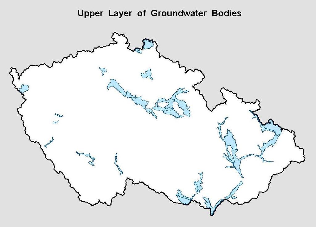
17 Hydrogeological zones and groundwater bodies of zones divided in three horizons: Upper horizon: Fluvial quaternary deposits, only significant for groundwater abstractions (38 zones), boundaries: geological, but simplified, average area: 130 km 2 Porous aquifers
18
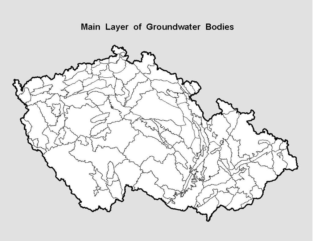
19 Main horizon surface presentation on maps all types of hydrogeological zones outcropping aquifers in sedimentary, volcanic and basement rocks (111 zones) Fissured and karst aquifers
20
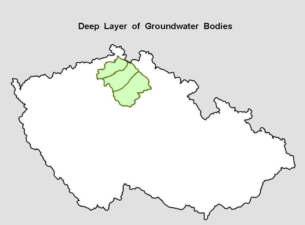
21 Last zone Deep horizon: 3 zones in cenomanian sandstone used for abstractions or significantly affected by human activity former uranium mining (acid discharge in 100 m deep boreholes) Fissured aquifers
22
23 Natural Characteristics of Groundwater Conceptual model of groundwater bodies in zone Main characteristics mineralisation (TDS), transmisivity, permeability, natural background of hydrochemistry, link between groundwater and surface water, vulnerability of groundwater to pollution
24 Groundwater use 93,4 % of inhabitants connected on public water supply Drinking water: 48,8 % of groundwater (2011) Use of groundwater: less than 30 % of existing groundwater resources Most of groundwater (82 %) used for drinking water
25 Groundwater resources in zones The method of baseflow calculation is the most common for regional assessment of dynamic groundwater resources and it represents volume of groundwater outflowing from individual groundwater zone (m3/s). Monitoring period of river gauging in time of 10 to 40 years is required for assessment of representative volume of groundwater resources. Dynamic groundwater resources represent important background information for national water balance and water management planning
26 Map of Groundwater Run-off in the Czechoslovakia (1979) Prepared by Czech / Slovak Hydrometeorological Institute Water Management Research Institute Czech / Slovak Geological Survey Synthetic map
27 Derived information Aquifer system - geological map 1 : (1966) - Quaternary sediments 1 : (1966) - Hydrogeological map 1 : ( ) (Water Master Plan map) - manuscript of national Hydrogeological map 1 : ( )
28 Basic aim Groundwater resources potential Long-term groundwater run-off - specific groundwater run-off - groundwater run-off coefficient Aquifer system with significant role in groundwater run-off
29 Specific groundwater run-off Amount of groundwater that is discharged from one square kilometer of aquifer (effluent streams / recharged by groundwater from adjacent aquifers) l / s / km 2 (expressed colors / in 8 degrees / 0.5 to 10)
30 Groundwater run-off coefficient groundwater run-off ration in rainfall (recharge to aquifers) % (expressed in isolines / variation 5 to 20)
31 Aquifers systems Spatially distributed hydrogeological units restricted by boundaries with specific marginal conditions System is generalized smaller alluvial and deluvial aquifers are not shown (despite to the importance)
32 Groundwater run-off Long-term river flow observation from about 250 river gauging stations Period of observation 10 to 12 years (some observations 40) Method of estimation Kille (1970)
33 Kille method Processing the monthly minimum run-off in form of graph linear part of graph represents amount of groundwater in river flow Resulting estimation is valid for watershed above the station and is generalized considering climatical, morphological hydrogeological (aquifer) factors
34 Accuracy Aquifers system boundaries Specific groundwater run-of - colors Groundwater run-off coefficient isolines (regional trends) Map represents artificially noninfluenced data (regional scale)
35 Legend Color long-term specific groundwater run-of + boundary Isoline of groundwater run-off coeff. Hatch ornaments types of aquifer systems Indexes stratigraphy / petrography Boundary lines
36 Long-term specific gw run-off Spec. Run-off Degree Significance Color less 0.5 I Insignificant yellow II Very low d. yellow 1 2 III Low l. brown 2 3 IV Medium orange 3 5 V Increased green 5 7 VI High d. green 7 10 VII Very high l. blue more 10 VIII Extr. high blue
37 Long-term run-off coeff. Isolines / expected isolines Isolines are not used in areas with remarkable fluctuation of values of groundwater run-off coefficient; the coefficient mean value given numerically below the data concerning the value of specific groundwater runoff
38 Aquifer systems One-aquifer Two-aquifer Multi-aquifer Territory without aquifer Continuous / non-continuous aquifers Intergranular / fissured / karst porosity
39 Aquifer systems porous Porous-fissured fissured fissured-karst fissured

40 Aquifer systems multilayered aquifers area without aquifers
41 Strat. and Petrograph. Indexes
42 Boundaries Bounds of values of specific run-off Aquifer systems Stratigraphical and petrographical units First and secon order waterhseds

43 North Western Bohemia

44 Western Bohemia
45 Thank you
Limits for the use of thermal waters on the example of the conceptual model of the Benesov-Usti aquifer system of the Bohemian Cretaceous basin PhD
 Limits for the use of thermal waters on the example of the conceptual model of the Benesov-Usti aquifer system of the Bohemian Cretaceous basin PhD thesis Résumé Josef V. DATEL, MSc. The very work was
Chapter 1 Introduction
 Engineering Hydrology Chapter 1 Introduction 2016-2017 Hydrologic Cycle Hydrologic Cycle Processes Processes Precipitation Atmospheric water Evaporation Infiltration Surface Runoff Land Surface Soil water
Supplemental Guide II-Delineations
 Supplemental Guide II-Delineations Contents Source Water Protection Area Delineation... 1 Delineation Criteria for Systems Using Groundwater Sources... 2 Time of Travel... 4 Flow Boundaries... 4 Delineation
GROUNDWATER POTENTIAL OF THE THIKA AREA, KENYA
 GROUNDWATER POTENTIAL OF THE THIKA AREA, KENYA SGL 413:PROJECT IN GEOLOGY Presented by: Muraguri Peter Njuguna Reg No. L13/21429/2008 Contents Study area Objectives Geology of the study area Hydrogeology
Potential effects evaluation of dewatering an underground mine on surface water and groundwater located in a rural area
 Potential effects evaluation of dewatering an underground mine on surface water and groundwater located in a rural area ITRODUCTIO Michel Mailloux* Eng. M.Sc, Vincent Boisvert, M.Sc, Denis Millette, Eng.,
Hydrogeology of East Anglia An Introduction
 East Land Quality Forum Hydrogeology of East Anglia An Introduction Richard Fry Ely Golf Club November 6 th 2012 1 2 Groundwater systems are complex and difficult to assess; they are based on aquifer systems
UK Technical Advisory Group on the Water Framework Directive
 UK Technical Advisory Group on the Water Framework Directive Defining & Reporting on Groundwater Bodies This Guidance Paper is a working draft defined by the UKTAG. It documents the principles to be adopted
Groundwater Level and Movement
 Groundwater Level and Movement Infiltration and Recharge Infiltration Entry of rain water into the ground. Recharge Addition of infiltrated water to the aquifer. Two types of Recharge- 1. Natural 2. Artificial
Stream hydrographs. Stream hydrographs. Baseflow. Graphs of river stage or discharge at a single location as a function of time
 Stream hydrographs Graphs of river stage or discharge at a single location as a function of time Hydrologic og budget Discharge: units? How is it measured? Show fluctuating water levels in response to
Hydrology and Water Management. Dr. Mujahid Khan, UET Peshawar
 Hydrology and Water Management Dr. Mujahid Khan, UET Peshawar Course Outline Hydrologic Cycle and its Processes Water Balance Approach Estimation and Analysis of Precipitation Data Infiltration and Runoff
CHAPTER 7 GROUNDWATER FLOW MODELING
 148 CHAPTER 7 GROUNDWATER FLOW MODELING 7.1 GENERAL In reality, it is not possible to see into the sub-surface and observe the geological structure and the groundwater flow processes. It is for this reason
CHAPTER 9 TABLE OF CONTENTS
 CHAPTER 9 TABLE OF CONTENTS Chapter 9 Table of Contents... i Chapter 9 List of Tables... i Chapter 9 List of Figures... i Chapter 9. GROUNDWATER STORAGE IN SANA'A BASIN... 504 Executive summary... 504
Managed Aquifer Recharge (MAR) Practical Techniques for the Caribbean
 Practical Techniques for the Caribbean") Managed Aquifer Recharge (MAR) Practical Techniques for the Caribbean Scope of Presentation What is MAR? Antigua and Barbuda water resources issues Why promote MAR? MAR: Techniques MAR: Design criteria
Managed Aquifer Recharge (MAR) Practical Techniques for the Caribbean Scope of Presentation What is MAR? Antigua and Barbuda water resources issues Why promote MAR? MAR: Techniques MAR: Design criteria
METHODOLOGY FOR RISK CHARACTERISATION OF IRELAND S GROUNDWATER. Paper by the Working Group on Groundwater
 Water Framework Directive (WFD) River Basin District Management Systems METHODOLOGY FOR RISK CHARACTERISATION OF IRELAND S GROUNDWATER Paper by the Working Group on Groundwater Guidance document no. GW8
EUROPEAN APPROACH IN ASSESSING GROUNDWATER VULNERABILITY OF THE MURÁNSKA PLANINA PLATEAU, SLOVAKIA
 EUROPEAN APPROACH IN ASSESSING GROUNDWATER VULNERABILITY OF THE MURÁNSKA PLANINA PLATEAU, SLOVAKIA P. MALÍK and J. ŠVASTA Geological Survey of Slovak Republic, Mlynska dolina 1, 817 04 Bratislava, Slovak
Understanding Earth Fifth Edition
 Understanding Earth Fifth Edition Grotzinger Jordan Press Siever Chapter 17: THE HYDROLOGIC CYCLE AND GROUNDWATER Lecturer: H Mohammadzadeh Assistant professors, Department of Geology, FUM Copyright 2007
SALINAS VALLEY GROUNDWATER BASIN SETTING INITIAL REVIEW FOR DEVELOPMENT OF GROUNDWATER SUSTAINABILITY PLAN
 1 SALINAS VALLEY GROUNDWATER BASIN SETTING INITIAL REVIEW FOR DEVELOPMENT OF GROUNDWATER SUSTAINABILITY PLAN May 10, 2018 Prepared for Salinas Valley Basin Groundwater Sustainability Agency Outline Purpose
working with you to develop practical water resources and environmental solutions
 working with you to develop practical water resources and environmental solutions LAKE MAITLAND WATER SUPPLY INTERIM REPORT Document Status Revision Date Revision Description a 21/12/2006 Interim Report
Closure Water Balance Model to Support Closure Designs for a Mine in Laos
 Page 1 Closure Water Balance Model to Support Closure Designs for a Mine in Laos BR Luinstra SRK Consulting (Australasia) JT Chapman SRK Consulting (Australasia) A Hendry SRK Consulting (Australasia) A
The SADC Hydrogeological Map & Atlas: Towards an improved understanding of groundwater regimes in Southern Africa
 The SADC Hydrogeological Map & Atlas: Towards an improved understanding of groundwater regimes in Southern Africa K. Pietersen 1, N. Kellgren 2, O. Katai 3 and M. Roos 4 (1) Water Geosciences Consulting,
Introduction to Groundwater Environmental Level Setting
 Introduction to Groundwater Environmental Level Setting 1.0 Introduction As part of work towards a Rangitāiki Water Management Area (WMA) plan change process for water quality and quantity, we will consider
CHAPTER ONE : INTRODUCTION
 CHAPTER ONE : INTRODUCTION WHAT IS THE HYDROLOGY? The Hydrology means the science of water. It is the science that deals with the occurrence, circulation and distribution of water of the earth and earth
STRAWMAN OUTLINE March 21, 2008 ISWS/ISGS REPORT ON THE OPPORTUNITIES AND CHALLENGES OF MEETING WATER DEMAND IN NORTH-EAST ILLINOIS
 STRAWMAN OUTLINE March 21, 2008 ISWS/ISGS REPORT ON THE OPPORTUNITIES AND CHALLENGES OF MEETING WATER DEMAND IN NORTH-EAST ILLINOIS REPORT TO BE DELIVERED TO THE RWSPG BY SEPTEMBER 30, 2008 Table of Contents
Groundwater Bodies in the UK
 Groundwater Bodies in the UK Rob Ward Head of Groundwater Science British Geological Survey 15 th December 2011 2nd Workshop on Groundwater Bodies in Europe Introduction Background Delineation in UK England,
Grounding Water: An Exploration of the Unseen World Beneath Our Feet
 1 Grounding Water: An Exploration of the Unseen World Beneath Our Feet Kerry Schwartz, Director, Arizona Project WET Protect Your Groundwater Day: Tuesday, September 9, 2014 What I Hope to Convey Groundwater
Groundwater drought in different geological conditions
 IOP Conference Series: Earth and Environmental Science Groundwater drought in different geological conditions To cite this article: A Machlica and M Stojkovova 2008 IOP Conf. Ser.: Earth Environ. Sci.
Review of Groundwater Information in the Lower Mekong Basin
 Review of Groundwater Information in the Lower Mekong Basin Khem Sothea Hydrology Team (Component-2) 17-19 February 2014 Bangkok & Khon Kean, Thailand FIRST MISSION OF USGS IN THE LMB (April 27 July 22,
AMERICAN INSTITUTE OF HYDROLOGY EDUCATIONAL CRITERIA
 AMERICAN INSTITUTE OF HYDROLOGY EDUCATIONAL CRITERIA AIH FORM011A Rev. 11/21/17 BASIC REQUIREMENTS Completion of a full course of study leading to a bachelor's or higher degree at an accredited college
Occurrence of Iron in Surface Waters of the Upper St. Johns River Basin
 Occurrence of Iron in Surface Waters of the Upper St. Johns River Basin Prepared by Florida Department of Environmental Protection Bureau of Watershed Management Ground Water Protection Section December
Wisconsin s Buried Treasure: Groundwater Basics. Kevin Masarik Center for Watershed Science and Education
 Wisconsin s Buried Treasure: Groundwater Basics Kevin Masarik Center for Watershed Science and Education Groundwater is Valuable to Wisconsin 95% of Wisconsin Communities 75% of Wisconsin Citizens rely
Overview. Students will...
 Overview Students will... Understand the interaction between ground water and surface water. Observe the difference between a permeable layer and an impermeable layer in an aquifer. See how water is stored
Groundwater in the Santa Rosa Plain
 . Groundwater in the Santa Rosa Plain Marcus Trotta, PG, CHg Principal Hydrogeologist Sonoma County Water Agency Santa Rosa Plain Groundwater Sustainability Agency October 12, 2017 www.sonomacountywater.org
PhD Program Water Technology Groundwater Hydrology (WTEC 9309)
") PhD Program Water Technology Groundwater Hydrology (WTEC 9309) Topic 1: Introduction and Occurrence of Groundwater Instructor: Prof. Dr. Yunes Mogheir 2018 1 1. Introduction Definitions and General Groundwater
PhD Program Water Technology Groundwater Hydrology (WTEC 9309) Topic 1: Introduction and Occurrence of Groundwater Instructor: Prof. Dr. Yunes Mogheir 2018 1 1. Introduction Definitions and General Groundwater
DHI Sverige AB, Honnörsgatan 16, P.O. Box 3289, SE Växjö, Sweden, 3
 Hydrological and Hydrogeological Effects of a Deep-Rock Repository for Spent Nuclear Fuel in Sweden: Application of a New Coupling Routine between MIKE SHE and MOUSE Erik MÅRTENSSON 1, Lars-Göran GUSTAFSSON
Modeling the Managed Aquifer Recharge for Groundwater Salinity Management in the Sokh River Basin
 Modeling the Managed Aquifer Recharge for Groundwater Salinity Management in the Sokh River Basin A. Karimov, 1 I. Gracheva, 2 F. Miryusupov 2 1 International Water Management Institute (IWMI) Central
4. Groundwater Resources
 4. Groundwater Resources 4-1 Majority (97 %) of unfrozen fresh water on earth exists as groundwater. In comparison to surface water, - groundwater is available all year around - groundwater is mostly invisible
8. Regional groundwater system
 8. Regional groundwater system 8-1 We have learned basic principles governing the flow and storage of groundwater. We will now use these principles to understand groundwater in the regional context. Flow
5. Basin Evaluation Salt and Nitrate Balance
 SNMP Attachment B, Section B.2.1.3 (originally Section 5 in CV-SALTS Phase 2 Conceptual Model Task 5 deliverables) 5. As part of the evaluation of water quality the SNMP requires loading estimates and
GROUNDWATER Dr. DEEPAK KHARE GENERAL HYDROLOGY CYCLE FORMATIONS
 GROUNDWATER By Dr. DEEPAK KHARE Associate Professor Department of Water Resources Development & Management Indian Institute of Technology Roorkee, ROORKEE (Uttaranchal) 247 667, India E-mail: kharefwt@iitr.ernet.in
CHAPTER 4: Risk Assessment Risk in Groundwater Contamination
 CHAPTER 4: Risk Assessment Risk in Groundwater Contamination Instructor: Dr. Yunes Mogheir -١ Introduction: Water pollution is nowadays one of the most crucial environmental problems world-wide. Pollution
Environmental Resource Inventories. What are ERIs? Significance of information How to use them
 Environmental Resource Inventories What are ERIs? Significance of information How to use them Environmental Resource Inventory - ERI Compiled by the environmental commission Information about the natural
Regional Groundwater Flow Modeling of Yarkant Basin in West China
 Conference on Environmental Pollution and Public Health Regional Groundwater Flow Modeling of Yarkant Basin in West China Sun Jinyu Zhang Qiang Xu Mo College of Environment and Civil Engineering, Chengdu
GROUNDWATER DISCHARGE
 GROUNDWATER DISCHARGE C O N N E C T I O N F A C T S H E E T S E R I E S D I S C H A R G E : The movement of groundwater from the subsurface to the surface P E R M E A B I L I T Y : The ability of a material
GROUNDWATER RESOURCES MANAGEMENT IN TANZANIA BY MR. LISTER R.E. KONGOLA ASSISTANT DIRECTOR WATER RESOURCES DIVISION
 GROUNDWATER RESOURCES MANAGEMENT IN TANZANIA BY MR. LISTER R.E. KONGOLA ASSISTANT DIRECTOR WATER RESOURCES DIVISION BACKGROUND Basic facts Location: Tanzania is located on the east coast of Africa and
Hydrogeology of Prince Edward Island
 Hydrogeology of Prince Edward Island General Characteristics and Groundwater on Prince Edward Island General Characteristics and Key Issues Issues PEI Dept. of Environment, Energy and Forestry 9/29/2009
STATE UNIVERSITY OF NEW YORK COLLEGE OF TECHNOLOGY CANTON, NEW YORK
 STATE UNIVERSITY OF NEW YORK COLLEGE OF TECHNOLOGY CANTON, NEW YORK COURSE OUTLINE CONS 385 Hydrology and Hydrogeology Prepared By: Adrienne C. Rygel, Ph.D. CANINO SCHOOL OF ENGINEERING TECHNOLOGY Department
Groundwater. Groundwater Movement. Groundwater Movement Recharge: the infiltration of water into any subsurface formation.
 On March 22, 2014, a major landslide occurred near Oso, Washington. Death toll currently at 30, with 15 still missing. Groundwater Before and After Swipe http://bit.ly/pen1jt N. Fork Stillaguamish River
Groundwater 3/16/2010. GG22A: GEOSPHERE & HYDROSPHERE Hydrology
 GG22A: GEOSPHERE & HYDROSPHERE Hydrology Definitions Groundwater Subsurface water in soil or rock that is fully saturated. Aquifer Contains enough saturated material to yield significant quantities of
Helena Valley Ground Water Monitoring Program
 Helena Valley Ground Water Monitoring Program James Swierc Lewis & Clark County Water Quality Protection District October 6, 2011 WQPD Sampling Program Overview Helena Area Water Related Issues Nutrient
CHAPTER 13 OUTLINE The Hydrologic Cycle and Groundwater. Hydrologic cycle. Hydrologic cycle cont.
 CHAPTER 13 OUTLINE The Hydrologic Cycle and Groundwater Does not contain complete lecture notes. To be used to help organize lecture notes and home/test studies. Hydrologic cycle The hydrologic cycle is
Ground Water Chapter 11
 Ground Water Chapter 11 How does water get underground? How is water stored underground? How does water move? How do we find it? Why we need to protect it. Lake Powell. Water levels are decreasing every
Generalization of parameters in the storage discharge relation for a low flow based on the hydrological analysis of sensitivity
 Proc. IAHS, 371, 69 73, 2015 doi:10.5194/piahs-371-69-2015 Author(s) 2015. CC Attribution 3.0 License. Generalization of parameters in the storage discharge relation for a low flow based on the hydrological
Groundwater modelling study for sustainable water management in Town of High River. Han Sang-Yoon WaterTech, April 12, 2013
 Groundwater modelling study for sustainable water management in Town of High River Han Sang-Yoon WaterTech, April 12, 2013 Acknowledgements Town of High River: Reiley McKerracher Jasen Craigie Project
CONTINUOUS RAINFALL-RUN OFF SIMULATION USING SMA ALGORITHM
 CONTINUOUS RAINFALL-RUN OFF SIMULATION USING SMA ALGORITHM INTRODUCTION Dr. R N Sankhua Director, NWA, CWC, Pune In this continuous rainfall-runoff simulation, we will perform a continuous or long-term
groundwater. Because watersheds are complex systems, each tends to respond differently to natural or human activities.
 The private development of Altos del María is located at an altitude between 550 and 1,000 meters above sea level in the environmentally sensitive Cordillera Central of Panama that separates the Pacific
Hydrogeology 101 3/7/2011
 Hydrogeology 101 W. Richard Laton, Ph.D., PG, CPG Associate Professor of Hydrogeology California State University, Fullerton Department of Geological Sciences 1 Hydrogeology 101 The objective is to obtain
GIS based watershed characterizations
 Abaya-Chamo Lakes Physical and Water Resources Characteristics, including Scenarios and Impacts Lake Abaya-Chamo Research Symposium, May 7 th -11 th, 2007, Arba Minch University, Ethiopia By Seleshi Bekele
Fitzpatrick Aquifer Delineation and Allocation. September 2017
 Fitzpatrick Aquifer Delineation and Allocation September 2017 Report writer: Subject: Rebecca Morris, Resource Scientist-Groundwater Fitzpatrick Aquifer - Delineation and Allocation Date: September 2017
Water Account, Mauritius 2013
 Republic of Mauritius Water Account, Mauritius 2013 Statistics Mauritius, Ministry of Finance and Economic Development June 15 Contents Foreword... III List of Symbols and Abbreviations... IV 1. Introduction...
POTENTIAL IMPACT OF MINING ACTIVITY ON XIN AN KARST SYSTEM, SHANXI, CHINA
 POTENTIAL IMPACT OF MINING ACTIVITY ON XIN AN KARST SYSTEM, SHANXI, CHINA ABSTRACT C.S. Wang The School of Resource and Earth Science, China University of Mining and Technology, Xuzhou, China 221008; E-mail:
Sanitary landfills. SWIM and Horizon 2020 Support Mechanism. Design of Long Term Solutions for Solid Waste Management
 SWIM and Horizon 2020 Support Mechanism Working for a Sustainable Mediterranean, Caring for our Future Design of Long Term Solutions for Solid Waste Management Sanitary landfills Presented by: Mr. Faouzi
AGRAR. Augmenting Groundwater Resources by Artificial Recharge. ICARDA, Aleppo, Syria nd November 2006
 AGRAR Augmenting Groundwater Resources by Artificial Recharge UNESCO G-WADI MEETING ON WATER HARVESTING ICARDA, Aleppo, Syria 20 22 nd November 2006 Project objectives BGS approached by DFID in 2000 to
Physiographic zones. and water quality
 Southland Physiographic zones Central Plains Technical information Physiographic zones are part of the Water and Land 2020 & Beyond project that aims to maintain and improve water quality in the Southland
Afghanistan. A Countrywide Overview of Groundwater Resources and Challenges By: Vincent W. Uhl
 Afghanistan A Countrywide Overview of Groundwater Resources and Challenges By: Vincent W. Uhl Country Overview Area: 647,500 km 2 Population: +/- 30 Million Economy: Principally Agriculture ¾ of the country
Rainwater Harvesting for Enhanced Groundwater Recharge Through Capture of Increased Runoff from Site Development
 Southern Illinois University Carbondale OpenSIUC 2006 Conference Proceedings 7-18-2006 Rainwater Harvesting for Enhanced Groundwater Recharge Through Capture of Increased Runoff from Site Development Mark
Groundwater basics. Groundwater and surface water: a single resource. Pore Spaces. Simplified View
 Groundwater and surface water: a single resource Santa Cruz River, Tucson Groundwater basics Groundwater is water found within the pore spaces of geologic material beneath the surface of the Earth. It
Rockland County s Water Resources -Selected Findings from the USGS Study- Paul M. Heisig, Hydrologist New York USGS Water Science Center Troy, NY
 Rockland County s Water Resources -Selected Findings from the USGS Study- Paul M. Heisig, Hydrologist New York USGS Water Science Center Troy, NY Subject to Permits Water Sources Rockland County, NY -Lake
Water Resources on PEI: an overview and brief discussion of challenges
 Water Resources on PEI: an overview and brief discussion of challenges Components: Components and links Atmospheric water Surface water (including glacial water) Groundwater Links: Precipitation (atm(
Types and hydrogeologic features of surface and groundwater interactions in Uzbekistan
 Types and hydrogeologic features of surface and groundwater interactions in Uzbekistan [1] Jusipbek KAZBEKOV, [2] Shavkat RAKHMATULLAEV, [3] Frédéric HUNEAU, [4] Philippe LE COUSTUMER [1] International
PAKISTAN S GROUNDWATER RESERVOIR AND ITS SUSTAINABILITY
 PAKISTAN S GROUNDWATER RESERVOIR AND ITS SUSTAINABILITY Muhammad Amin Member Water, WAPDA, 705-WAPDA-House Lahore, Pakistan ABSTRACT Pakistan s major groundwater resource is in the irrigated areas of the
Global Water. Globally, 1.2 billion people live in areas with water supply.source:internationalwater
 Water Resources Global Water Globally, 1.2 billion people live in areas with water supply.source:internationalwater inadequate How sustainable are freshwater resources? 80 countries with 40% of world pop.
Groundwater in Bayfield County. Madeline Gotkowitz Hydrogeologist April 23, 2015
 Groundwater in Bayfield County Madeline Gotowitz Hydrogeologist April 23, 2015 Groundwater in Bayfield County Groundwater basics Hydrogeology across Wisconsin Hydrogeology in Bayfield County Mapping groundwater
Chapter 4. Water Sources Potential
 Chapter 4 Water Sources Potential 4 Water Sources Potential 4.1 General The main concept of selecting the suitable water resources for the provision of water to the villages should satisfy the following
6-5 Analysis of water storage state by the subsurface dam
 6-5 Analysis of water storage state by the subsurface dam From the results of the study and the observation described above, an analysis of the water storage mechanism by the subsurface dam was carried
GLY 155 Introduction to Physical Geology, W. Altermann. Grotzinger Jordan. Understanding Earth. Sixth Edition
 Grotzinger Jordan Understanding Earth Sixth Edition Chapter 17: THE HYDROLOGIC CYCLE AND GROUNDWATER 2011 by W. H. Freeman and Company Chapter 17 The Hydrologic Cycle and Groundwater 1 About the Hydrologic
Mapping of the Basseterre Valley Aquifer
 Mapping of the Basseterre Valley Aquifer Coastal Aquifer Management in Caribbean SIDS Workshop, St. Kitts-Nevis Halla Sahely, Ph.D., P.Eng St. Kitts Water Services Department October 11, 2010 Participating
Integrating wetlands and riparian zones in regional hydrological modelling
 Integrating wetlands and riparian zones in regional hydrological modelling Fred Hattermann, Valentina Krysanova & Joachim Post Potsdam Institute for Climate Impact Research Outline Introduction Model concept:
Groundwater and surface water: a single resource. Santa Cruz River, Tucson
 Groundwater and surface water: a single resource Santa Cruz River, Tucson 1942 1989 1 Groundwater basics Groundwater is water found within the pore spaces of geologic material beneath the surface of the
Technical Rules: Assessment Report. Clean Water Act, 2006
 Technical Rules: Assessment Report Clean Water Act, 2006 November 20, 2008 Amended on: December 12, 2008 (administrative amendments) November 16, 2009 (EBR Posting Number EBRO10-7573) Clean Water Act,
Research on Sustainable Utilization of Shallow Geothermal Resources in Beijing, China
 Proceedings World Geothermal Congress 2015 Yu Yuan, China, 19-25 April 2015 Research on Sustainable Utilization of Shallow Geothermal Resources in Beijing, China Yu Yuan, Zheng Jia and Zou Yuanlin China
Irrigation. Branch. Groundwater Quality in the Battersea Drainage Basin
 AGRICULTURE, FOOD AND RURAL DEVELOPMENT Irrigation Branch Groundwater Quality in the Battersea Drainage Basin Groundwater quality in the Battersea drainage basin was monitored between 1995 and 21 to characterize
ENGINEERING HYDROLOGY
 ENGINEERING HYDROLOGY Prof. Rajesh Bhagat Asst. Professor Civil Engineering Department Yeshwantrao Chavan College Of Engineering Nagpur B. E. (Civil Engg.) M. Tech. (Enviro. Engg.) GCOE, Amravati VNIT,
Technical Rules - March 2017
 Ministry of the Environment and Climate Change Source Protection Programs Branch Technical Rules - March 2017 Amended on: December 2008 (administrative amendments) November 2009 (EBR Posting Number EBR
DEVELOPMENT OF AQUIFER TESTING PLANS. Brent Bauman, P.G. / Erin Lynam, Aquatic Biologist
 DEVELOPMENT OF AQUIFER TESTING PLANS Brent Bauman, P.G. / Erin Lynam, Aquatic Biologist DEVELOPMENT OF AQUIFER TESTING PLANS Goals of Aquifer Testing What questions are we trying to answer Staff review
2.3 Water Budget Data In Ontario
 2.3 Water Budget Data In Ontario Water budget data available for Ontario includes meteorologic data, hydrometric data and groundwater data. Geological and physiographical data provide information to describe
General Groundwater Concepts
 General Groundwater Concepts Hydrologic Cycle All water on the surface of the earth and underground are part of the hydrologic cycle (Figure 1), driven by natural processes that constantly transform water
CHAPTER FIVE Runoff. Engineering Hydrology (ECIV 4323) Instructors: Dr. Yunes Mogheir Dr. Ramadan Al Khatib. Overland flow interflow
 Instructors: Dr. Yunes Mogheir Dr. Ramadan Al Khatib. Overland flow interflow") Engineering Hydrology (ECIV 4323) CHAPTER FIVE Runoff Instructors: Dr. Yunes Mogheir Dr. Ramadan Al Khatib Overland flow interflow Base flow Saturated overland flow ١ ٢ 5.1 Introduction To Runoff Runoff
Engineering Hydrology (ECIV 4323) CHAPTER FIVE Runoff Instructors: Dr. Yunes Mogheir Dr. Ramadan Al Khatib Overland flow interflow Base flow Saturated overland flow ١ ٢ 5.1 Introduction To Runoff Runoff
A Primer on Groundwater
 Anderson, 2007 A Primer on Groundwater Brian Smerdon, Alberta Geological Survey North Saskatchewan Watershed Alliance Groundwater Forum, 27 February 2019 Groundwater: Part of the water cycle Barker et
Numerical Modeling of Groundwater Flow in Karst Aquifer, Makeng Mining Area
 American Journal of Environmental Sciences 6 (1): 78-82, 2010 ISSN 1553-345X 2010 Science Publications Numerical Modeling of Groundwater Flow in Karst Aquifer, Makeng Mining Area 1,2 F.M. Rani and 1 Z.H.
Establishing the influence of climate, water extraction and tectonics on the water level of the Prespa Lakes (N Greece)
") Establishing the influence of climate, water extraction and tectonics on the water level of the Prespa Lakes (N Greece) Tim van der Schriek & Christos Giannakopoulos National Observatory of Athens Institute
Establishing the influence of climate, water extraction and tectonics on the water level of the Prespa Lakes (N Greece) Tim van der Schriek & Christos Giannakopoulos National Observatory of Athens Institute
Wisconsin s Buried Treasure
 Wisconsin s Buried Treasure Kevin Masarik Center for Watershed Science and Education Through the University of Wisconsin-Extension, all Wisconsin people can access University resources and engage in lifelong
Vermillion River Headwaters Groundwater Recharge Area Inventory and Protection Plan
 Vermillion River Headwaters Groundwater Recharge Area Inventory and Protection Plan A project funded through a Metro Environmental Partnership grant from the Metropolitan Council with technical analysis
Using Fractran Fracture Flow Modeling in Tandem with Modflow to Assist in the Development of Wellfield Protection Zones for Municipal Wells in Bedrock
 Using Fractran Fracture Flow Modeling in Tandem with Modflow to Assist in the Development of Wellfield Protection Zones for Municipal Wells in Bedrock T.K. Wiezel 1, G.G. Violette 1 and S.T. Hamilton 2
Assessment of the Groundwater Quantity Resulting from Artificial Recharge by Ponds at Ban Nong Na, Phitsanulok Province, Thailand
 Research article erd Assessment of the Groundwater Quantity Resulting from Artificial Recharge by Ponds at Ban Nong Na, Phitsanulok Province, Thailand SIRIRAT UPPASIT* Faculty of Technology, Khon Kaen
Information Request 11
 Information Request 11 Information Request 11 11-1 Responses to Information Request 11 Response to Information Request 11a Response to Information Request 11b 11-2 11-6 Federal Review Panel Information
CONCEPTUAL MODELS AIMING TO PROTECT FROM PESTICIDE CONTAMINATION DRINKING WATER PRODUCTION FROM GROUNDWATER
 CONCEPTUAL MODELS AIMING TO PROTECT FROM PESTICIDE CONTAMINATION DRINKING WATER PRODUCTION FROM GROUNDWATER Engida ZA Hydrogeology Sub Process Manager Water Works Design and Supervision Enterprise WATER
1. Introduction. Keywords Groundwater, Vulbnerability, Aquifer, Aquitard, Vadose zone. Alsharifa Hind Mohammad
 World Environment 2014, 4(1): 22-32 DOI: 10.5923/j.env.20140401.03 New Groundwater Vulnerability Index for the Main Aquifers in Central Catchment Area in Jordan and Validation of the Results Using NO 3
GROUNDWATER BASICS SUBJECTS: TIME: MATERIALS: OBJECTIVES Math (Advanced), Science (Physics) 1 class period
, Science (Physics) 1 class period") 9-12 GROUNDWATER BASICS SUBJECTS: Math (Advanced), Science (Physics) TIME: 1 class period MATERIALS: calculator paper pencil student sheet and figures OBJECTIVES The student will do the following: 1. Compute
9-12 GROUNDWATER BASICS SUBJECTS: Math (Advanced), Science (Physics) TIME: 1 class period MATERIALS: calculator paper pencil student sheet and figures OBJECTIVES The student will do the following: 1. Compute
9.1 Introduction. 9.2 Issues
 9 Groundwater 9.1 Introduction Groundwater is the water that occupies or moves through openings, cavities or spaces in geological formations under the ground. It is an important resource to many of Otago
groundwater/surface-water interactions Evan Christianson, PG Barr Engineering Company
 groundwater/surface-water interactions Evan Christianson, PG Barr Engineering Company Discussion of. Groundwater/Surface-Water Interactions Groundwater Recharge Impacts from Pumping Potential effect on