Use of WARSSS in Stream Restoration and Watershed Planning. Michigan Aquatic Restoration Conference 2015
|
|
|
- Winifred Bell
- 5 years ago
- Views:
Transcription

1 Use of WARSSS in Stream Restoration and Watershed Planning Michigan Aquatic Restoration Conference 2015 October 22, 2015

2 Use of WARSSS in Stream Restoration and Watershed Planning 1. Watershed Management Planning 2. Catchment-Scale Restoration Management Plans 3. Clean Sediment, Biota, and D.O. TMDLs 4. Reach-Scale Stream Restoration Design 5. Habitat and Biological Monitoring
3 Watershed Assessment of River Stability and Sediment Supply Geomorphology-based framework for evaluating river stability Disproportionate sediment/tp supply Assess instability causes Prioritize restoration efforts Developed with the USEPA

4 Rosgen, 2014
5 Sediment Supply Clean sediments (i.e., non-toxic) Sediment-starved reaches Sources of disproportionately high sediment loads

6 Departure Analysis
7 Watershed Scale Source: Center for Watershed Protection

8 Belle River Watershed Plan
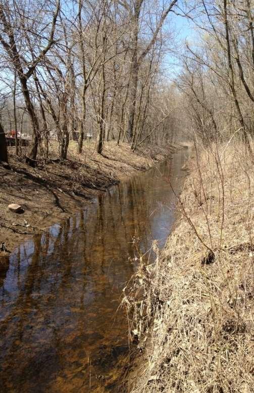
9 Belle River Longitudinal Profile Adapted from Knutilla, 1969
10 Streambank Erosion Screening Stream Types Bank Height Ratio (>1.5 = High/VH) Radius of Curvature-to-Width (<2.25) Altered Riparian Vegetation (mowed turf grass, bare soil, or tilled areas)

11 Watershed Planning: In-Stream Pollutants, Sources, and Causes Source: MDEQ, 2000

12 Impervious Cover Model Belle R. Source: Center for Watershed Protection
13 River Instability Processes Over-widening Accelerated downstream meander migration Chute cutoffs Aggradation (excessive deposition) Degradation (downcutting or incision)
14 Signs of Excess Deposition Pool filling Most of bed exposed during low flow Slope reversals Coarse over-bank deposition Transverse bars; mid-channel bars; side bars
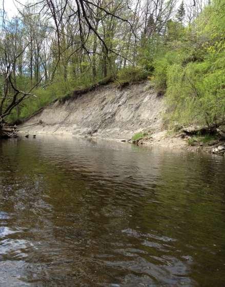
15 Signs of Degradation Exposed till river bed Nickpoints caused by headcutting Stream tributary rejuvenation Steep bars Leaning trees, vertical banks
16 Geomorphic Thresholds Bank height exceeds1.3 x bankfull depth Width-to-Depth Ratio exceeds 1.4 x reference W:d Shift in stream type >25% of banks or vegetation impacted >30% riffle embeddedness >20% pool filling with fine sediment

17 Historic Aerials Time Trend
18 Look for man-made impacts Channelization, dredging, relocation Bed lowering at road crossings Dams, weirs, rock dams, in-line ponds Altered riparian vegetation; cattle Floodplain encroachment; riprap Wood removal; clearing and snagging Excess sediment supply, construction Gravel mining
")
19 (Rosgen, 2007)

20 Belle River ICD
21 Belle R. IC Drain Departure Analysis Parameter Measure Reference (Richmond Twp) Impaired (ICD) Lateral Stability Width-to - Depth Ratio 18.8 Stable 12.0 Stable Vertical Stability D84 (or Di bar) 2 in. Gravel Stable Silt/clay Aggrading Vegetation Class Tree/Shrub/ Grass Stable Turf Grass Not Functioning Floodplain Connectivity Bank Ht Ratio 1.0 Functioning 2.3 Channelized Entrenchment Ratio 7.9 Functioning 1.5 No Floodplain Hydraulics Gradient 0.112% Functioning % Not Functioning Shear Stress 0.22 lb/ft 2 Sediment Competence 0.08 lb/ft 2 Depositional

22 Deposition, Excessive Wood Removal

23 Natural 2-Stage Ditch Analog

24 Hillslope Failures

25 Natural Toe Wood Analog

26 Subwatershed Restoration Master Plans
27 Subwatershed Master Planning Communicate with multiple landowners Cost savings Leverage infrastructure expenses Various restoration approaches which vary by site constraints
28 Level of Action Required 1. Protection and conservation 2. Riparian management 3. Empirical (adaptive) management approach 4. Active restoration (or combined approach)
29 Phasing by Focus Area Infiltration, tile control structures Water on the landscape Fish passage: culvert replacement, weirs Sediment regime: gravel augmentation, excessive fines Cattle or human access points Floodplain excavation Tree planting Instream habitat: wood
30 TMDLs

31 Dissolved Oxygen TMDLs SOD; algae decomposition >>> anoxic Sulfide and ammonia toxicity Source: G Fred Lee

32 Reach-Scale Restoration
33
34

35 Typical Channelized Stream

36 Floodplain Connectivity Restored
37
38 Microhabitat-Scale Assessments Limiting Factor Analysis Assess specific facets (ex. pools) Interpret biomonitoring results
39
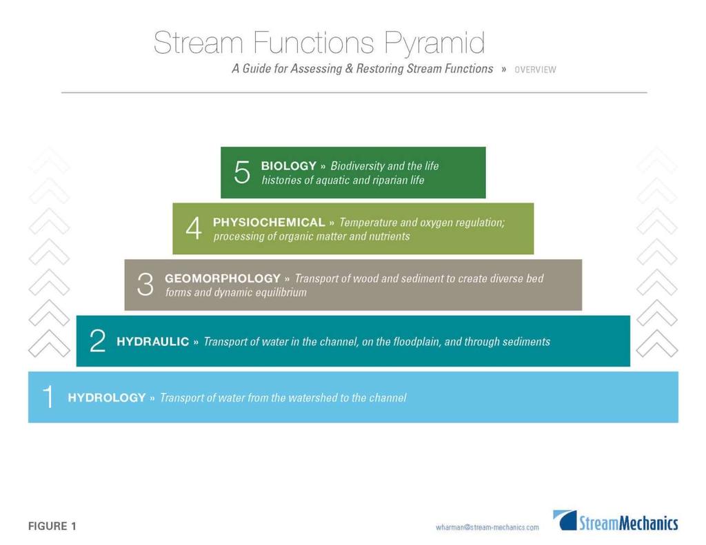
40 Assessing Stream Functions Parameter Simple Measure Intensive Measure Floodplain connectivity Bank Height Ratio Entrenchment Ratio Stage vs. discharge Bedform diversity % Riffles and pools Max. pool depth Variable depth, velocity, Froude number Lateral stability Streambank erosion Replicate cross-sections Riparian vegetation Buffer density, width Vegetation plots Adapted from Harman, et al. 2012
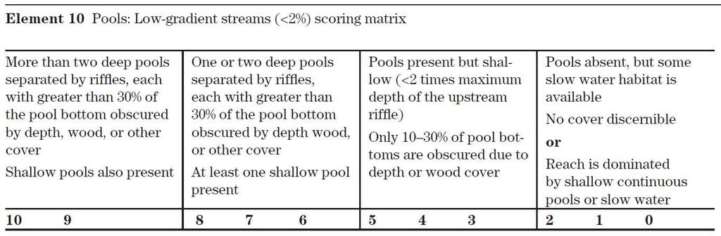
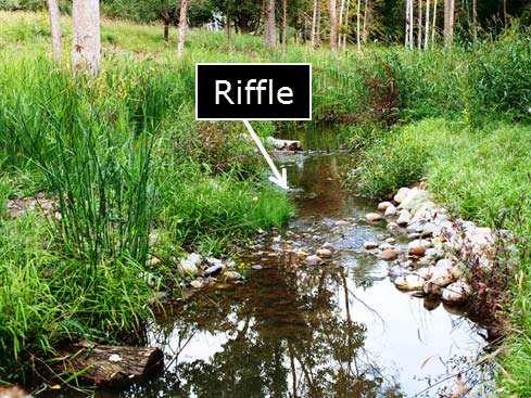
41 Qualitative Habitat Assessment (ex. pools)
42 Ex. Quantitative Pool Assessment Pool type, pool dimensions, pool slope, point bar slope Pool Length to Riffle Width Dimensionless Ratios Pool Max. Depth to Riffle Mean Depth Pool Slope to Avg. Slope Lateral Scour Pool Mean Min. Max.

43 Interpreting Biomonitoring Results by Stream Type (Source: Friends of the Rouge, 2015)
44 Questions?
Watershed Hydrology: Go with the flow. Greg Jennings, PhD, PE
 Watershed Hydrology: Go with the flow Greg Jennings, PhD, PE jenningsenv@gmail.com Streams What are your CHALLENGES? Hydrology too much water Pollutants upstream and on-site Vegetation wrong plants, wrong
Stream Restoration Raccoon Creek A Case Study
 Stream Restoration Raccoon Creek A Case Study Restoration of a Degraded Stream System Steven Glickauf Presentation Overview Stream Restoration Raccoon Creek Restoration Site Case Study Existing Conditions
IMPROVING OUTCOMES FOR STREAM ALTERATION PROJECTS
 IMPROVING OUTCOMES FOR STREAM ALTERATION PROJECTS Bethany Matousek Inland Lakes and Streams Program Coordinator Wetlands, Lakes and Streams Unit DEQ Water Resources Division MatousekB@Michigan.gov 517-243-6421
Old Mill School Stream Restoration
 Project Overview This conceptual plan restores and stabilizes two consecutive reaches of a highly incised and unstable stream and reconnects them with the floodplain. The restoration reaches are part of
Mill Creek Restoration in Lower Merion Township. PH (610) ; FAX (610) ;
 ; FAX (610) ;") Mill Creek Restoration in Lower Merion Township Vincent L. Sortman 1 and Robert M. Lambert 2 1 Biohabitats, Inc., 15 W. Aylesbury Road, Timonium, MD 21093; PH (410) 337-3659; FAX (410) 583-5678; email:
Mill Creek Restoration in Lower Merion Township Vincent L. Sortman 1 and Robert M. Lambert 2 1 Biohabitats, Inc., 15 W. Aylesbury Road, Timonium, MD 21093; PH (410) 337-3659; FAX (410) 583-5678; email:
Stream Assessment Form (Form 1) Unified Stream Methodology for use in Virginia
 Unified Stream Methodology for use in Virginia") Stream Assessment Form (Form 1) Unified Stream Methodology for use in Virginia Project Name For use in wadeable channels classified as intermittent or perennial Cowardin HUC Date SAR # Class. Impact/SAR
Stream Assessment Form (Form 1) Unified Stream Methodology for use in Virginia Project Name For use in wadeable channels classified as intermittent or perennial Cowardin HUC Date SAR # Class. Impact/SAR
Introduction to stream assessment
 Why do stream assessment? Introduction to stream assessment Given the current condition of rivers and the heightened public interest in them, there is a significant need for the ability to determine the
LITTLE SHADES CREEK RESTORATION PROJECT CWA Section 319(h) Nonpoint Source Implementation Grant Project Workplan #17 ADEM Contract #C
 Nonpoint Source Implementation Grant Project Workplan #17 ADEM Contract #C") LITTLE SHADES CREEK RESTORATION PROJECT CWA Section 319(h) Nonpoint Source Implementation Grant Project Workplan #17 ADEM Contract #C90593066 PARTNERS Alabama Department of Environmental Management Cawaco
LITTLE SHADES CREEK RESTORATION PROJECT CWA Section 319(h) Nonpoint Source Implementation Grant Project Workplan #17 ADEM Contract #C90593066 PARTNERS Alabama Department of Environmental Management Cawaco
South St. Vrain / Hall Meadows Restoration Planning August 20, 2015
 South St. Vrain / Hall Meadows Restoration Planning August 20, 2015 Agenda Introductions Purpose & Goals of Meeting Planning Area Master Plan Restoration Planning: Cost Estimates, Grants, Scope, Timeline
PROJECT SCREENING MATRIX: A User s Guide
 Version 2.0 Page 1 of 7 November 9, 2010 PROJECT SCREENING MATRIX: A User s Guide BACKGROUND The Project Screening Matrix (Screening Matrix) is one of several tools that comprise the River Restoration
Ten Principles of River Restoration and Four River Project of Korea
 Ten Principles of River Restoration and Four River Project of Korea Randolph T. Hester, G. Mathias Kondolf, Marcia McNally, Department of Landscape Architecture and Environmental Planning University of
STREAM RESTORATION PURPOSE, PRACTICE, AND METHODS. By Marcus Rubenstein, CPESC
 STREAM RESTORATION PURPOSE, PRACTICE, AND METHODS By Marcus Rubenstein, CPESC WHAT IS STREAM RESTORATION? The return of a stream s lost natural functions, usually resulting from watershed alterations,
Stream Restoration in the Urban Environment Concepts and Considerations
 Stream Restoration in the Urban Environment Concepts and Considerations The Restoration of Our Rivers; October 5, 2012 Matthew A. Van Eps, PE & Sandi J. Formica: Watershed Conservation Resource Center
Stream Condition Assessment 2013
 US Army Corps of Engineers Galveston District Regulatory Branch P.O. Box 1229 2000 Ft Point RD Galveston, Texas 77553-1229 Phone: 409-766-3982 Fax: 409-766-3931 E-mail: ceswg-pe-r@usace.army.mil US Army
Stream Restoration at Road Crossings in Northern Wisconsin. Dale Higgins, USDA Forest Service
 Stream Restoration at Road Crossings in Northern Wisconsin Dale Higgins, USDA Forest Service Key Points Large # of road and trail stream crossings on the landscape Many crossings adversely impact streams
Background. AEM Tier 2 Worksheet Stream & Floodplain Management. Glossary
 AEM Tier 2 Worksheet Stream & Floodplain Management Glossary Bankfull Stage: The stage at which water starts to flow over the flood plain; the elevation of the water surface at bankfull discharge. (This
* For applicants utilizing bank for compensatory mitigation requirements, information below is not applicable.
 Mitigation Plan (33 CFR 332.4(c)/40 CFR 230.92.4(c)) A mitigation plan is required for all forms of compensatory mitigation, whether permittee-responsible mitigation, mitigation banks, or in-lieu fee mitigation
3.0 Stream Assessment
 3.0 Stream Assessment 3.1 Methods Stream aquatic integrity in urban settings is directly affected by the physical changes in the watershed, some of which result in the degradation of the chemical and/or
FORM B: DAMMING AND DIVERSION OF WATER
 APPLICATION FOR RESOURCE CONSENT FORM B: DAMMING AND DIVERSION OF WATER NOTES Resource use activities must meet all the conditions of any relevant Permitted Activity Rules in the Waikato Regional Plan
In re: Town of Norwich Pool Dam Reconstruction, Stream Alteration Permit Application
 Agency of Natural Resources October 20, 2015 Neil R. Fulton Town Manager Town of Norwich P.O. Box 376 Norwich, VT 05055 In re: Town of Norwich Pool Dam Reconstruction, Stream Alteration Permit Application
4.1 Traditional Approach versus Geomorphic Approach
 RESTORATION 4.0 Introduction As we discussed in the Watersheds and Streams Section, many streams have been severely impacted by urbanization as a result of changes in their hydrologic and sediment regimes,
Application for resource consent Form B Damming and diversion of water
 Application for resource consent Form B Damming and diversion of water Notes Resource use activities must meet all the conditions of any relevant Permitted Activity Rules in the Waikato Regional Plan or
NCS Design Approach. Biology/Ecology Primer. Presented by: Jack Imhof, National Biologist Trout Unlimited Canada
 NCS Design Approach Biology/Ecology Primer Presented by: Jack Imhof, National Biologist Trout Unlimited Canada Biology/Ecology Key biological principles that are applied Need to speak the same language
Stream Simulation in Very Low Gradient Channels
 University of Massachusetts - Amherst ScholarWorks@UMass Amherst International Conference on Engineering and Ecohydrology for Fish Passage International Conference on Engineering and Ecohydrology for Fish
MONITORING RECOMMENDATIONS
 MONITORING RECOMMENDATIONS 9 The purpose of this section is to provide general guidance on proposed monitoring activities to provide information for several of the recommended indicators and key uncertainties
Assessing physical habitat condition using River MImAS
 Assessing physical habitat condition using River MImAS Why? What? How? Chris Bromley Ecology Partnership & Development Unit SEPA Overview Why did we chose the MImAS approach? What is MImAS? How does it
May 15, Lower Squaw Creek Restoration Public Workshop. for The Friends of Squaw Creek Truckee River Watershed Council Sierra Nevada Conservancy
 Lower Squaw Creek Restoration Public Workshop for The Friends of Squaw Creek Truckee River Watershed Council Sierra Nevada Conservancy Prepared by: Mike Liquori May 15, 2008 Funding for this project has
WHY ARE STREAM IMPROVEMENTS NEEDED IN TENNESSEE? TENNESSEE STREAMS
 WHY ARE STREAM IMPROVEMENTS NEEDED IN TENNESSEE? TENNESSEE STREAMS Most diverse aquatic fauna in the country Majority of West TN streams are channelized 36,000 miles of degraded stream are in need of restoration
Bluff Creek One Water
 Bluff Creek One Water The Bluff Creek Watershed has no lakes within its boundaries. As the westernmost watershed within the District, land use changes from agricultural to residential have occurred relatively
Table D1: WC-R1 to WC-R3 (Wilket Creek Park)
") APPENDIX D Table D1: WC-R1 to WC-R3 (Wilket Creek Park) Category of Consideration Criteria Alternative 1 Do Nothing Alternative 2 Local Improvements Alternative 3 Channel Realignment Natural Geomorphic
APPENDIX D Table D1: WC-R1 to WC-R3 (Wilket Creek Park) Category of Consideration Criteria Alternative 1 Do Nothing Alternative 2 Local Improvements Alternative 3 Channel Realignment Natural Geomorphic
UNIFIED STREAM METHODOLOGY
 UNIFIED STREAM METHODOLOGY for use in Virginia U.S. Army Corps of Engineers, Norfolk District Virginia Department of Environmental Quality January 2007 Table of Contents Acronyms, Equations, Examples,
FINAL REPORT. Dry Gulch Stream Restoration
 FINAL REPORT Dry Gulch Stream Restoration Biological and Agricultural Engineering Department North Carolina State University Raleigh, North Carolina Town of Carrboro Carrboro, North Carolina December 15,
Western Strait Drainages. Watershed Summaries DRAINAGES EST WRIA 19 EST
 Page 31 WESTERN STRAIT DRAINAGES EST WRIA 19 WEST EST Snow, Bullman, Jansen & Olsen Creeks Sekiu River Hoko & Little Hoko Rivers Clallam River & Estuary Pysht River & Estuary Green Creek Jim & Joe Creeks
Habitat Grant Projects Clinton River Watershed
 Habitat Grant Projects Clinton River Watershed L Y N N E S E Y M O U R E N V I R O N M E N T A L E N G I N E E R O F F I C E O F T H E M A C O M B C O U N T Y P U B L I C W O R K S C O M M I S S I O N
Beaver Creek Hydrology, LLC. Franklin, Tennessee
 Beaver Creek Hydrology, LLC. Franklin, Tennessee The Harpeth River Blueway Problems with Harpeth River EPA s 303(d) Listed for siltation, habitat alteration, nutrient enrichment and low dissolved oxygen
Treatment Strategies based on Stream Stratification Methodology by W. Barry Southerland Fluvial Geomorphologist, WNTSC, USDA, NRCS
 Treatment Strategies based on Stream Stratification Methodology by W. Barry Southerland Fluvial Geomorphologist, WNTSC, USDA, NRCS Cedar Creek, WA - 2005 Cedar Creek, WA - 2005 Asotin Creek, WA 2005: photo
Hydrologic Regime; Past and Present and Water Quality Implications
 Hydrologic Regime; Past and Present and Water Quality Implications Waseca County Water Plan Meeting Waseca County Courthouse Annex November 16, 2016 Dan Girolamo, Area Hydrologist, Waterville, MN Topics
Quittapahilla Creek Watershed Implementation Plan
 Quittapahilla Creek Watershed Implementation Plan Introduction Founded in 1997, the Quittapahilla Creek Watershed Association has been working with landowners, private organizations and public agencies
Griswold Creek Subwatershed
 Griswold Creek Subwatershed Griswold Creek is located in Chester and Russell Townships and flows into the Chagrin River in the Village of Hunting Valley. Since the forming of the Chagrin River Watershed
7.0 WATER-BASED CONTROL MEASURES
 7.0 WATER-BASED CONTROL MEASURES 7.1 IDENTIFICATION AND DESCRIPTION OF CONTROL MEASURES Table 7-1 lists the water-based options being considered for implementation in the initial screening stage. Descriptions
Site Selection and Design for Stream Mitigation
 Site Selection and Design for Stream Mitigation Will Harman, PG Stream Mechanics The Association of State Wetland Managers State/Tribal/Federal Coordination Meeting March 19-21, 2013 NCTC Our Relationship
Fish Passage and Abundance around Grade Control Structures on Incised Streams in Western Iowa
 Fish Passage and Abundance around Grade Control Structures on Incised Streams in Western Iowa John Thomas Hungry Canyons Alliance Mary Culler Iowa State University / Missouri DNR Dimitri Dermisis IIHR
Town of Aurora Stream Management Master Plan PUBLIC INFORMATION CENTRE May 1 st, 2018
 Town of Aurora Stream Management Master Plan PUBLIC INFORMATION CENTRE May 1 st, 2018 Your comments are encouraged and appreciated, as this will provide us an opportunity to address project issues and
DEVELOPING A WATERSHED IMPROVEMENT PLAN TO MEET MULTIPLE COMMUNITY OBJECTIVES IN GAINESVILLE AND HALL COUNTY, GEORGIA
 DEVELOPING A WATERSHED IMPROVEMENT PLAN TO MEET MULTIPLE COMMUNITY OBJECTIVES IN GAINESVILLE AND HALL COUNTY, GEORGIA Chrissy, Thom 1, David Dockery 2, Kevin McInturff 3, Betsy Massie 1, and Lauren Murphy
County-wide Stream Inventory Data Analysis. Executive Summary August 2011
 Introduction County-wide Stream Inventory Data Analysis Executive Summary August 2011 Arlington County completed a County-wide assessment of streams to determine condition and restoration potential for
Chapter Three: Discussion and Conclusion. 3.1 Introduction/Overview. 3.2 Countywide Stream Assessment
 3.1 Introduction/Overview The objective of this study was to develop a stream prioritization tool that evaluates stream reaches in terms of the potential water quality improvements that could be achieved
Logan River at Rendezvous Park, Channel and Floodplain Restoration: Crack Willow (Salix fragilis) Issues and Management Strategies
 Issues and Management Strategies") Logan River at Rendezvous Park, Channel and Floodplain Restoration: Crack Willow (Salix fragilis) Issues and Management Strategies Prepared May 2, 2017 by Darren Olsen, BIO-WEST, Inc. Issues Crack willow
Logan River at Rendezvous Park, Channel and Floodplain Restoration: Crack Willow (Salix fragilis) Issues and Management Strategies Prepared May 2, 2017 by Darren Olsen, BIO-WEST, Inc. Issues Crack willow
Restoration of Riparian Forests and Riparian Ecosystem Processes and Implications for Salmon Restoration. Katie Ross-Smith Jennifer Hammond
 Restoration of Riparian Forests and Riparian Ecosystem Processes and Implications for Salmon Restoration Katie Ross-Smith Jennifer Hammond Outline > Background California riparian communities Riparian
Understanding and Restoring Natural Floodplain Function. Gary James CTUIR Fisheries Program Manager
 Understanding and Restoring Natural Floodplain Function Gary James Fisheries Program Manager Future of Our Salmon Technical Workshop on Healthy Floodplains Spokane, WA - August 16-18, 2016 Presentation
FIGURE 12-1 FUNCTIONS AND BENEFITS OF HEALTHY STREAMS
 12.0 Introduction This chapter summarizes the analysis and design methodology for drainageway improvements within the County. Definitions are provided for minor and major drainageways and design considerations
Natural Channel Design and Dead River Case Study Stream Restoration in the Great Lakes Basin: Using In-stream Structures & Natural Channel Design
 Natural Channel Design and Dead River Case Study Stream Restoration in the Great Lakes Basin: Using In-stream Structures & Natural Channel Design January 22, 2013 S. Paige Baker, PE, MLE Presentation Outline
Stream Watch Visual Survey Instructions
 Stream Watch Visual Survey Instructions The Stream Watch Visual Survey is based on assessment parameters from the EPA's Rapid Bioassessment Protocol Habitat Assessment, Georgia Adopt a Stream Visual Survey,
Massachusetts River and Stream Crossing Standards: Technical Guidelines
 Massachusetts River and Stream Crossing Standards: Technical Guidelines August 6, 2004 INTRODUCTION As long and linear ecosystems, rivers and streams are very important for fish and other wildlife movements,
Gwinnett County Dept. of Water Resources Watershed Improvement Program. Russell Manley, CFM, Gwinnett County DWR Kevin Middlebrooks, CH2M
 Gwinnett County Dept. of Water Resources Watershed Improvement Program Russell Manley, CFM, Gwinnett County DWR Kevin Middlebrooks, CH2M Gwinnett County: Population: 859,000 Area: 437 sq. miles 2,000 miles
Jason R. Vogel, Ph.D., P.E. Biosystems and Agricultural Engineering Oklahoma State University
 Stormwater 101 OKLAHOMA STATE UNIVERSITY Biosystems and Agricultural Engineering Department Jason R. Vogel, Ph.D., P.E. Biosystems and Agricultural Engineering Oklahoma State University Stormwater is excess
Low Head Stone Weirs By: Jon Fripp 1, Dr. Craig Fischenich 2, and Dr. David Biedenharn 2
 Low Head Stone Weirs By: Jon Fripp 1, Dr. Craig Fischenich 2, and Dr. David Biedenharn 2 Complexity Low Moderate High Environmental Value Low Moderate High Cost Low Moderate High OVERVIEW Establishing
STREAMBANK RESTORATION DESIGN
 STREAMBANK RESTORATION DESIGN WITH VINYL SHEET PILE GRADE CONTROL STRUCTURES BRUCE M. PHILLIPS, M.S., P.E. ABSTRACT Grade control structures are an effective channel stabilization measure which can eliminate
Restoring Ecological & Geomorphic Function on the Heartrock Ranch
 Restoring Ecological & Geomorphic Function on the Heartrock Ranch DAVE ROSGEN BRANDON ROSGEN WILDLAND HYDROLOGY FORT COLLINS, COLORADO RIVER RESTORATION 2018, TWO HARBORS, MN OCTOBER 29 TH, 2018 Cooperators
Hydrology Attribute 1/15/2016. California Rapid Assessment Method for Wetlands. Hydrology. Precipitation Increases the Extent of Wetlands
 California Rapid Assessment Method for Wetlands Hydrology Attribute Hydrology Determines existence of wetlands, drives primary physical and ecological processes: Establishment of reducing conditions Nutrient
STREAM DISSOLVED OXYGEN IMPROVEMENT FEASIBILITY STUDY
 DUPAGE RIVER SALT CREEK WORKGROUP STREAM DISSOLVED OXYGEN IMPROVEMENT FEASIBILITY STUDY FOR SALT CREEK FINAL REPORT SEPTMEBER 2009 Prepared by: HDR Engineering, Inc. 8550 W. Bryn Mawr Ave., Suite 900 Chicago,
2012 Mill Creek Watershed Habitat Assessment Level 3 Project Study Plan Results
 2012 Mill Creek Watershed Habitat Assessment Level 3 Project Study Plan Results Cranberry Run This project study plan was financed through a Sub-grant from the Ohio EPA with funds from the State of Ohio.
Floodplain Restoration with Large Wood
 Floodplain Restoration with Large Wood Caitlin Alcott, CE, CFM ASFPM Conference June 21, 2016 Overview: 1. Functions of large wood in rivers and floodplains 2. Human impacts on large wood dynamics 3. Design
CROSBY BROOK RESTORATION STUDY BRATTLEBORO, VT
 Key Stakeholders: CROSBY BROOK RESTORATION STUDY BRATTLEBORO, VT Funded By: VT Dept. of Environmental Conservation VT Agency of Transportation (VTrans) Town of Brattleboro NEWEA Spring Meeting Omni Mt.
Urban and Suburban Stream Restoration Structures
 Urban and Suburban Stream Restoration Structures Examples, guidance, construction and long-term performance 3 Rivers Wet Weather Stream Restoration Symposium June 22, 2018 Kelly Lennon, PE Vice President
Galveston District Stream Condition Assessment June 2013
 Determination of Compensation 5.0 Determination of Compensation Requirements (Credits) This section describes the methods and alternatives for fulfilling the Compensation Requirement (CR), representing
FAIRFIELD COUNTY STREAM MANAGEMENT GUIDE
 FAIRFIELD COUNTY STREAM MANAGEMENT GUIDE INTRODUCTION The Fairfield Soil and Water Conservation District (SWCD) has assembled this stream management guide to assist interested landowners in protecting
INTERMEDIATE BMI ASSESSMENT TIER 2 FIELD SHEET
 INTERMEDIATE BMI ASSESSMENT TIER 2 FIELD SHEET PHYSICAL PARAMETERS ASSESSMENT FIELD SHEET ALL TIERS NAME: DATE: TIME: STREAM OR RIVER NAME: WATERSHED NAME: TOWN: WEATHER PRESENT PAST 48 HOURS SITE DESCRIPTION
Glossary of Terms. Aquifer A permeable body of rock capable of yielding quantities of groundwater to wells and springs.
 Glossary of Terms 100-year flood A large, but infrequent, flood event that has a 1% chance of occurring in any given year (occurs, on average, once every 100 years). 100-year floodplain Areas adjacent
River Restoration in Iowa is there anything fishy going on here? or Fish Habitat in Iowa
 River Restoration in Iowa is there anything fishy going on here? or Fish Habitat in Iowa Jeff Kopaska Iowa Water Conference Ames, IA March 22, 2018 Where did we start? Lea, 1836 In every part of this whole
Department of the Army Corps of Engineers. State of Missouri Stream Mitigation Method
 Department of the Army Corps of Engineers State of Missouri Stream Mitigation Method Updated February 2007 A. GENERAL INFORMATION 1. Regulatory Authorities & Guidelines B. ADVERSE IMPACT FACTORS 1. Stream
Restoration of Abandoned Channels. Prepared for KICT, South Korea. Pierre Y. Julien, Ph.D. Seema C. Shah-Fairbank Jaehoon Kim
 Restoration of Abandoned Channels Prepared for KICT, South Korea by Pierre Y. Julien, Ph.D. Seema C. Shah-Fairbank Jaehoon Kim Colorado State University April 2008 Statement of Work 1. Classification and
Appendix X: Non-Point Source Pollution
 Appendix X: Non-Point Source Pollution Sources Nonpoint source of pollution, unlike pollution from industrial and sewage treatment plants, comes from many different sources. Nonpoint source pollution is
Ongoing and Completed Studies
 Attachment 2 Ongoing and Completed Studies 2014 Monitoring and Analysis Plan November 2013 Attachment 2 Ongoing and Completed Studies 1 Introduction In 2013, the small interdisciplinary study groups for
Natural flood management guidance:
 Practical Guidence Natural flood management guidance: Woody dams, deflectors and diverters July 2016 Natural flood management guidance: Woody dams, deflectors and diverters July 2016 1 Introduction Large
Developing Tools for Hydromodification Management and Assessment
 Developing Tools for Hydromodification Management and Assessment Hydromodification: Channel Erosion Before Development After Development Increase in: - Imperviousness - Drainage Slope - Direct Runoff Decrease
Bridge Planning Updates. Bridge Planning Practitioners Workshop April 2012
 Bridge Planning Updates Bridge Planning Practitioners Workshop April 2012 Bridge Website Bridge Website Bridge Website Bridge Website BPG 11 Stormwater Management at Rural Bridges Released July 2010 Documents
RIPARIAN CORRIDOR STUDY FINAL PARLEYS CREEK MANAGEMENT PLAN TABLE OF CONTENTS
 TABLE OF CONTENTS 1.0 INTRODUCTION... 1-1 Riparian Corridor Study and Management Plan Goals... 1-1 Study Area... 1-2 Importance and Functions of Riparian Corridors... 1-2 Habitat for Mammals, Birds, and
Ithaca Creek Habitat Monitoring
 Ithaca Creek Habitat Monitoring My name is: Class: Date: Ithaca Creek is part of the Catchment. Today when I was walking at the creek I decided that I wanted to investigate how healthy my waterway was.
Rainfall, runoff and sediment transport in the Napa River watershed: now and a possible future
 Rainfall, runoff and sediment transport in the Napa River watershed: now and a possible future Lester McKee San Francisco Estuary Institute 5/24/2017 1 The importance of the natural water cycle of infiltration
Voluntary Water Quality Conservation Plan
 Voluntary Water Quality Conservation Plan Plan Table of Contents A. Mid Coast Agricultural Water Quality Management Area Rules and Plan Overview B. Landowner Resource/Practice Inventory C. Recommended
Case Study 19. Mill Creek Embedded Box Culvert Vented Ford
 Case Study. Mill Creek Embedded Box Culvert Vented Ford Location Southeast Missouri. Mark Twain National Forest; Houston-Rolla Ranger District. Southeast of Rolla, south of Interstate 44, off of State
Boulder Elkhorn TMDL Project. TMDL Document Public Comment Meeting June 27, 2013
 Boulder Elkhorn TMDL Project TMDL Document Public Comment Meeting June 27, 2013 Presentation Outline: What are TMDLs? Boulder Elkhorn TMDL Project Area What s in a TMDL document? Sediment Overview Temperature
Monitoring Report #3 Kenston Lake Stream Restoration Bainbridge, Ohio
 Monitoring Report #3 Kenston Lake Stream Restoration Bainbridge, Ohio Prepared by: EnviroScience, Inc. 5070 Stow Rd Stow OH 44224 (330) 688-0111 Year Ending: December 31, 2013 I. Project Overview The following
Water and Watersheds. Data Maps Action
 Water and Watersheds Data Maps Action What is the Wildlife Action Plan? Restore rare wildlife and habitats. Keep common species common. 2015 Revision: Partners in Conservation Science 2015 Revision Data
RED LAKE WATERSHED DISTRICT MONTHLY WATER QUALITY REPORT May 2014
 Long-Term Monitoring Program The first round of samples was completed and a second round was started for the Red Lake Watershed District long term monitoring program. We ve had plenty of runoff and high
TEMPORARY STREAM DIVERSION
 ILLINOIS URBAN MANUAL PRACTICE STANDARD TEMPORARY STREAM DIVERSION (ft,) CODE 976 (Source: Aukland Regional Council Stream Facts) DEFINITION A temporary channel or pipe used to convey stream flow around
Temporary Watercourse Crossing: Fords
 Temporary Watercourse Crossing: Fords DRAINAGE CONTROL TECHNIQUE Low Gradient Velocity Control Short Term Steep Gradient Channel Lining Medium-Long Term Outlet Control Soil Treatment Permanent [1] [1]
U.S. EPA Presentation Stormwater Program Update
 U.S. EPA Presentation Stormwater Program Update Prepared by: Bob Newport, NPDES Programs Branch, U.S. EPA Region 5 Presented by: Christe Alwin, MS4 Program Specialist, Lansing District Office, DEQ Stormwater
CHAPTER 1 INTRODUCTION. Stream processes are strongly related to the physical conditions of the
 1 CHAPTER 1 INTRODUCTION Stream processes are strongly related to the physical conditions of the watershed from which they flow. Alterations to physical conditions of a watershed manifest themselves through
1/30/2014. SR-BOK Outcomes. Sue Niezgoda, Gonzaga University January 28, Depth. Breadth
 SR-BOK Outcomes Sue Niezgoda, Gonzaga University January 28, 2014 Breadth Depth 1 Foundational Outcomes Hydrology Hydraulics Fluvial geomorphology Sediment Transport Stream Ecology Habitat Structure and
WATERSHED AND STREAM MANAGEMENT GUIDELINES for Lands and Waters Managed by Missouri Department of Conservation
 WATERSHED AND STREAM MANAGEMENT GUIDELINES for Lands and Waters Managed by Missouri Department of Conservation ii iii WATERSHED AND STREAM MANAGEMENT GUIDELINES Introduction...1 Key Assumptions and Facts..1
Today s Webinar: Types of Monitoring and Assessment Data and What They Mean
 Welcome to the 1 st Webinar in the Series Monitoring & Assessment for Watershed Plans: Identifying, Accessing, and Using Data to Protect and Restore Indiana s Waters Each Monday in May at noon Today s
Temporary Watercourse Crossing: Culverts
 Temporary Watercourse Crossing: Culverts DRAINAGE CONTROL TECHNIQUE Low Gradient Velocity Control Short Term Steep Gradient Channel Lining Medium-Long Term Outlet Control Soil Treatment Permanent Symbol
TRCA Natural Channel Design Monitoring Program. SOSMART Group Meeting December 7, 2010
 TRCA Natural Channel Design Monitoring Program SOSMART Group Meeting December 7, 2010 Natural Channel Design (NCD) Reconstruction of a stream channel and floodplain using techniques to restore or replicate
The Streamkeepers Handbook
 The Streamkeepers Handbook A Practical Guide To Stream And Wetland Care Appendix 1 COMMON HABITAT RESTORATION TECHNIQUES Check Table 3 for the references that provide detailed instructions for these projects.
Crooked Creek Storm Water Master Plan
 Final Crooked Creek Storm Water Master Plan Submitted to Gwinnett County, Georgia July 2003 Contents Executive Summary...ES-1 Background... ES-1 Purpose of the Storm Water Master Plan... ES-2 Regulatory
Stormwater Management Tools: Real-Life Solutions for a Resilient Community Riparian Corridor Protection
 Stormwater Management Tools: Real-Life Solutions for a Resilient Community Riparian Corridor Protection Montgomery County Planning Commission October 24, 2013 Eric Jarrell, Assistant Section Chief, Community
4. Ponds and infiltration BMPs can achieve 60 to 100% removal efficiencies for sediment.
 Landscape BMPs For the purposes of this project, preventive measures have been categorized into two categories: landscape BMPs and source prevention BMPs. Landscape BMPs includes both vegetative practices
Created by Simpo PDF Creator Pro (unregistered version) Asst.Prof.Dr. Jaafar S. Maatooq
 Asst.Prof.Dr. Jaafar S. Maatooq") Lect.No.9 2 nd Semester Barrages, Regulators, Dams 1 of 15 In order to harness the water potential of a river optimally, it is necessary to construct two types of hydraulic structures, as shown in Figure
Lect.No.9 2 nd Semester Barrages, Regulators, Dams 1 of 15 In order to harness the water potential of a river optimally, it is necessary to construct two types of hydraulic structures, as shown in Figure
Prepared for Urban Drainage and Flood Control District
 BERM FAILURE TECHNICAL ANALYSES SOUTH PLATTE GRAVEL PIT EVALUATION CRITERIA Prepared for Urban Drainage and Flood Control District Wright Water Engineers, Inc. January 2013 121-030.000 TABLE OF CONTENTS