UPTOWN TRAFFIC IMPACT ANALYSIS
|
|
|
- Sheena Gallagher
- 5 years ago
- Views:
Transcription
1 UPTOWN TRAFFIC IMPACT ANALYSIS This memorandum summarizes the results of the traffic analysis conducted to evaluate the traffic operations of the intersections along Post Oak Boulevard within Uptown Houston in the Year 2018 and Year The study limits are Richmond Avenue on the south and IH 610 southbound frontage road on the north. The vicinity map of the study area is presented in Figure 1. The study was conducted with an objective of analyzing the traffic operations under Year 2018 and Year 2035 traffic conditions and developing measures to mitigate the impact of the increased traffic along the roadways that would be generated by planned residential and commercial developments in the core area of Uptown Houston. Background Several commercial and residential establishments are proposed to be developed in the Uptown area. By Year 2018, it is anticipated that 12.7 million square feet of office space and 4.8 million square feet of retail space will be developed in Uptown Houston along the Post Oak Boulevard corridor. By Year 2035, 17.8 million square feet of office space and 5.04 million square feet of retail space will be developed. Additionally, 6,100 units of multi-family residential development and over 6,700 hotel rooms will be developed by 2018, and by 2035, 9,425 units of multi-family residential development and around 8,300 hotel rooms will be developed. The future development information is included in Attachment A of this report. Existing Conditions The land use in the study area is a mix of residential and commercial developments. The Post Oak Boulevard corridor from IH 610 on the north to Richmond Avenue on the south constitutes the core area of Uptown Houston. Regional access to the study area is provided by US 59 and IH 610. Westheimer Road, San Felipe Street, and Richmond Avenue are the major thoroughfares providing direct access to the study area.
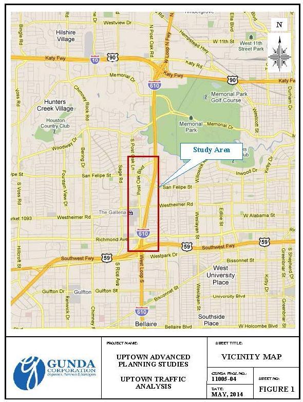
2 Figure 1
3 Traffic Analysis Intersection Level of Service () analyses were performed in accordance with the procedures set forth and recommended by the Highway Capacity Manual (HCM) Level of Service methodologies for evaluation of signalized and unsignalized intersections. Traffic analysis software Synchro was used to evaluate the operation of the study intersections. The Level of Service criteria for signalized and unsignalized intersections are listed below in Table 1. A is considered as best, free-flow condition and F is considered failing conditions. D is considered acceptable during the peak hours by most agencies. Table 1 Level of Service () Criteria for Intersections Signalized Intersection Unsignalized Intersections (sec/veh) (sec/veh) A B >10-20 >10-15 C >20-35 >15-25 D >35-55 >25-35 E >55-80 >35-50 F >80 >50 The SYNCHRO network for the Uptown Area has been utilized for conducting traffic analysis. The traffic volume data for the study network was available for the year Based on the Houston-Galveston Area Council s (H-GAC) traffic demand model networks for years 2009 and 2025, it was determined that the study area will experience an annual growth rate of 0.75%, which was used to project the traffic volumes to Base Year Based on the comparison of traffic volumes between AM and PM peak hour, it was determined that PM peak hour represents the highest peak hour. Utilizing the projected traffic volumes, the Year 2011 weekday peak hour levels of service for the study intersections were evaluated. The existing PM peak hour levels of service of the analysis intersections are summarized in Table 2 (following page). As presented in Table 2, some of the study intersections would operate at levels of service E or F. Traffic Projection Methodology Based on the H-GAC s travel demand model networks for years 2009, 2025 and 2035, it was determined that the study area will experience an annual growth rate of 0.75%, between 2011 and 2018, and an annual growth rate of 0.5% between 2018 and At these rates, the study area will experience a growth of 5.25% between 2011 and 2018, and 8.5% between 2018 and 2035.
4 The proposed development and employment information for Years 2011, 2018 and 2035 was provided by Uptown Houston for the Traffic Analysis Zones (TAZs) within the Uptown core area. Based on the employment data for Uptown, it has been estimated that the traffic volumes in the study area will increase 15% by Year 2018 and 39% by Year Table 2 Year 2011 Traffic Conditions and Study Intersections (Sec/Veh) 1 Richmond Ave. at IH 610 NBFR D Post Oak Blvd. at Richmond Ave. E Post Oak Blvd. at Fairdale Dr. 1,2 B Post Oak Blvd. at Hidalgo St. B Post Oak Blvd. at W. Alabama St. C Post Oak Blvd. at Westheimer Rd. E Post Oak Blvd. at Locke Ln. 1,2 A Post Oak Blvd. at Guilford Ct. 1,2 B Post Oak Blvd. at Ambassador Way C Post Oak Blvd. at BLVD Place C Post Oak Blvd. at San Felipe St. E Post Oak Blvd. at Westbriar Ln. 1,2 A Post Oak Blvd. at Four Oaks Pl./Garretson Ln. B Post Oak Blvd. at Uptown Park Blvd. C Post Oak Blvd. at IH 610 SBFR F Post Oak Blvd. at IH 610 NBFR F Notes = Level of service 1 Unsignalized intersection in Intersection signalized by 2018 However, based on the employment data from H-GAC for Year 2035, it has been estimated that the traffic volumes in the study area will increase 22% by Year After reviewing the employment data from Uptown Houston and H-GAC, the background (No-Build) condition traffic volumes for the analysis intersections were developed by increasing the Year 2011 volumes by 15% for Year 2018 and 22% for Year 2035.
5 Background Traffic Conditions Utilizing the projected traffic data for the study intersections, the Year 2018 and Year 2035 background PM peak hour levels of service for the study intersections were calculated. The background PM peak hour levels of service of the analysis intersections are summarized in Table 3. As presented in Table 3, some of the study intersections would be operating at levels of service E or F under Year 2018 traffic conditions and delays would increase under Year 2035 traffic conditions. Table 3 Year 2018 & 2035 Background Traffic Conditions and - PM Peak Hour Study Intersections LO S Year 2018 Year 2035 (Veh/Sec ) LO S (Veh/Sec ) 1 Richmond Ave. at IH 610 NBFR E 78.4 F Post Oak Blvd. at Richmond Ave. F 98.5 F Post Oak Blvd. at Fairdale Dr. 1,2 B 14.7 B Post Oak Blvd. at Hidalgo St. C 20.3 C Post Oak Blvd. at W. Alabama St. D 37.8 D Post Oak Blvd. at Westheimer Rd. F F Post Oak Blvd. at Locke Ln. 1,2 A 7.1 A Post Oak Blvd. at Guilford Ct. 1,2 B 16.8 B Post Oak Blvd. at Ambassador Way C 24.3 C Post Oak Blvd. at BLVD Place D 39.1 D Post Oak Blvd. at San Felipe St. F 96.3 F Post Oak Blvd. at Westbriar Ln. 1,2 B 11.1 B Post Oak Blvd. at Four Oaks Pl./Garretson C 21.0 C Post Oak Blvd. at Uptown Park Blvd. D 48.4 E Post Oak Blvd. at IH 610 SBFR F F Post Oak Blvd. at IH 610 NBFR F F Note s = Level of service Alternative Transportation System Improvements The existing freeways serving the Uptown Houston area are congested. As indicated in the previous section, major intersections in the core Uptown area are operating at unacceptable levels of service. Also, the existing roadway network
6 will not be able to provide efficient access to the traffic generated by the new developments. In order to meet the transportation needs in Uptown Houston, Uptown Development Authority is considering various alternative transportation system improvements, such as, widening of Post Oak Boulevard, construction of Bellaire Uptown Transit Center with shuttle buses, and implementation of high capacity transit in Uptown Houston. Project (Build) Conditions Uptown Houston, METRO, the City of Houston, and other stakeholders have long recognized the need for high capacity transit within Uptown Houston. Plans for improved transit options in Uptown have been documented by most of the agencies. In addition to proposed transit improvements, the reconstruction of Post Oak Boulevard has been in the City of Houston Capital Improvement Plan (CIP). Transit Service along Post Oak Boulevard Traffic analysis was conducted to evaluate the traffic operations along Post Oak Boulevard between Richmond Avenue and IH 610. The transit buses would circulate between Uptown Intermodal Terminal and Northwest Transit Center at five (5) minute headway, which translates to 12 buses entering and exiting the Bellaire Uptown Transit Center every hour. The ridership estimates indicated that the proposed transit service, by Year 2018, is estimated to attract approximately 2,150 riders during the PM peak hour, out of which 1,200 are oriented towards the north and the remaining 950 are oriented towards the south. By 2035, it is estimated that the proposed transit service will attract approximately 3,120 riders during the PM peak hour, out of which 1,570 are oriented towards the north and the remaining 1,550 are oriented towards the south. As a result of the operation of the transit service, there will be a reduction in vehicle trips entering and exiting the Uptown core area. In order to estimate the reduction in vehicle trips, a vehicle occupancy rate of 1.25 passengers per car is assumed. By applying this rate to the number of riders, by 2018 the number of reduced vehicle trips is estimated to be 960 in the northbound direction and 760 in the southbound direction during PM peak hour. By 2035, the number of reduced trips is estimated to be 1,256 in the northbound direction and 1,240 in the southbound direction during PM peak hour. Utilizing future development information provided by Uptown Houston, the origin of transit trips was estimated. It is estimated that the 50% of the transit trips are generated from the Uptown core area between Richmond Avenue and Westheimer Road, 30% generated between Westheimer Road and San Felipe
7 Street, and the remaining 20% generated from the Traffic Analysis Zones (TAZs) between San Felipe Street and IH 610 southbound frontage road. Based on the location and size of the developments in each of the TAZs, the vehicle trips were reduced from Year 2018 and Year 2035 traffic turning movements at the appropriate study intersections along Post Oak Boulevard within the Uptown core area. A comparison of Year 2018 and Year 2035 no build conditions and build conditions PM peak hour delays and levels of service of the analysis intersections is presented in Table 4.
8 Study Intersections Table 4 Comparison of Year 2018 & Year 2035 No Build and Build Conditions and - PM Peak Hour Year 2018 Year 2035 No Build Build % (Veh/Sec) (Veh/Sec) Reduction in No Build Build % (Veh/Sec) (Veh/Sec) Reduction in 1 Richmond Ave. at IH 610 NBFR E 78.4 E % F 85.9 F % 2 Post Oak Blvd. at Richmond Ave. F 98.5 F % F F % 3 Post Oak Blvd. at Fairdale Dr. B 14.7 B % B 16.5 B % 4 Post Oak Blvd. at Hidalgo St. C 20.3 B % C 21.4 C 20 7% 5 Post Oak Blvd. at W. Alabama St. D 37.8 C % D 46.9 D % 6 Post Oak Blvd. at Westheimer Rd. F F % F F % 7 Post Oak Blvd. at Locke Ln. A 7.1 A 7.1 0% A 8.3 A % 8 Post Oak Blvd. at Guilford Ct. B 16.8 B % B 19.7 B % 9 Post Oak Blvd. at Ambassador Way C 24.3 C % C 27.1 C % 10 Post Oak Blvd. at BLVD Place D 39.1 D % D 42.4 D % 11 Post Oak Blvd. at San Felipe St. F 96.3 E % F E % 12 Post Oak Blvd. at Westbriar Ln. B 11.1 A % B 12.4 A 5 60% 13 Post Oak Blvd. at Four Oaks Pl. C 21 C % C 24.3 C % 14 Post Oak Blvd. at Uptown Park Blvd. D 48.4 C % E 63.9 C % 15 Post Oak Blvd. at IH 610 SBFR F F % F F % 16 Post Oak Blvd. at IH 610 NBFR F F % F F % Notes = Level of service
9 Travel Time Comparison In order to evaluate the effectiveness of the transit service, travel times along the anticipated transit service route between Bellaire Uptown Transit Center and Northwest Transit Center were compared for the no-build and build scenarios and summarized in Table 5. As presented in Table 5, there is a reduction in travel time under the build scenario. Findings Table 5 Travel Time Comparison Segment No Build Bellaire Uptown Transit Center - Richmond Avenue 5 2 PM Build Post Oak Boulevard Richmond Avenue to IH Post Oak Boulevard to Northwest Transit Center 11 5 Total Based on the results of the traffic analysis, the following observations have been made: The implementation of transit service in the study area resulted in the reduction of intersection delays in Year 2018 and Year 2035, when compared to no-build conditions. In the year 2018, the intersections would experience up to 53% reduction in delay following the implementation of transit service. In the Year 2035, the intersections would experience up to 60% reduction in delay following the implementation of transit service. The travel time would reduce by 42% following the implementation of transit service. The results of the analyses conducted for both Year 2018 and 2035 traffic conditions indicate that the implementation of transit service would result in the improved traffic operations at the intersections along Post Oak Boulevard within Uptown Houston.
Future Build Alternative Traffic Forecasts and Level of Service Analysis
 4.2.10 Future Build Alternative Traffic Forecasts and Level of Service Analysis For the five Build Alternatives, study intersections within one mile of potential station locations were analyzed, as it
CHAPTER 2: MODELING METHODOLOGY
 CHAPTER 2: MODELING METHODOLOGY 2.1 PROCESS OVERVIEW The methodology used to forecast future conditions consisted of traditional traffic engineering practices and tools with enhancements to more accurately
City of Berkeley. Guidelines for Development of Traffic Impact Reports
 Office of Transportation (OOT) City of Berkeley Guidelines for Development of Traffic Impact Reports Office of Transportation, City of Berkeley 1 1. Overview These guidelines provide a framework to help
ALBION FLATS DEVELOPMENT EXISTING TRAFFIC CONDITIONS AND POTENTIAL IMPACTS
 EXISTING TRAFFIC CONDITIONS AND POTENTIAL IMPACTS FINAL REPORT SEPTEMBER 2010 TABLE OF CONTENTS 1.0 INTRODUCTION 1 2.0 EXISTING TRAFFIC CONDITIONS 2 3.0 FUTURE TRAFFIC CONDITIONS 3 4.0 POTENTIAL IMPACTS
TRAFFIC STUDY GUIDELINES
 TRAFFIC STUDY GUIDELINES December 2013 The scope of the traffic impact analysis (TIA) should follow these guidelines and the requirements of VMC 11.80.130 and VMC 11.70, transportation concurrency (attached
4.11 TRANSPORTATION AND CIRCULATION
 4.11 TRANSPORTATION AND CIRCULATION 4.11.1 INTRODUCTION This section addresses the potential for the Proposed Project to impact traffic and circulation. Information in this section is summarized from the
CHAPTER 2 - TRAVEL DEMAND MODEL DEVELOPMENT
 CHAPTER 2 - TRAVEL DEMAND MODEL DEVELOPMENT 2.1 EXISTING TRAVEL DEMAND MODEL In order to accurately project future year traffic volumes within this regional study area, it was first necessary to construct
CITY OF CLOVIS Traffic Impact Study Guidelines
 CITY OF CLOVIS Traffic Impact Study Guidelines CLOVIS, A WAY OF LIFE Approved August 25, 2014 City Council Resolution 2014-79 Prepared by City of Clovis Engineering Division Steve White, City Engineer
3.6 GROUND TRANSPORTATION
 3.6.1 Environmental Setting 3.6.1.1 Area of Influence The area of influence for ground transportation consists of the streets and intersections that could be affected by automobile or truck traffic to
Woodburn Interchange Project Transportation Technical Report
 Final Report Woodburn Interchange Project Transportation Technical Report Prepared for Oregon Department of Transportation April 212 Prepared by DKS Associates Contents Methodologies... 4 Volume Development...
VIII. LAND USE ISSUES
 VIII. LAND USE ISSUES The & Route 57 Land Use and Circulation Study (Land Use Study, Figure 6) was completed for the Town of Clay in November 1999 (Clough, Harbour & Associates). This study investigated
TRAFFIC & TRANSPORTATION COMMISSION AGENDA REPORT
 TRAFFIC & TRANSPORTATION COMMISSION AGENDA REPORT AGENDA ITEM #4 T/T MTG: 092616 DATE: SEPTEMBER 26, 2016 TO: TRAFFIC & TRANSPORTATION COMMISSION FROM: BENJAMIN CHAN, P.E, T.E., DEPUTY PUBLIC WORKS DIRECTOR
Strasburg Road Extension Rush Meadow Street to New Dundee Road Alternative Route Study Report
 Strasburg Road Extension Rush Meadow Street to New Dundee Road Alternative Route Study Report July 2012 TABLE OF CONTENTS Strasburg Road Extension Rush Meadow Street to New Dundee Road City of Kitchener
Traffic Impact Study Requirements
 [TYPE THE COMPANY NAME] Traffic Impact Study Requirements County of San Mateo Department of Public Works Roadway Services 9/1/2013 I. Introduction The County of San Mateo (County), Department of Public
Traffic Impact Study Guidelines. City of Guelph
 Traffic Impact Study Guidelines City of Guelph April 2016 Engineering and Capital Infrastructure Services Infrastructure, Development & Enterprise 1 Carden Street Guelph, Ontario Canada N1H 3A1 Page 1
CITY OF LA MESA MIXED-USE OVERLAY ZONE PROJECT La Mesa, California August 15, 2007 Revised January 16, 2008
 TRAFFIC IMPACT STUDY CITY OF LA MESA MIXED-USE OVERLAY ZONE PROJECT La Mesa, California August 15, 2007 Revised January 16, 2008 Prepared for: DUDEK & ASSOCIATES 605 Third Street Encinitas, California
BCEO TRAFFIC IMPACT STUDY GUIDELINES
 BCEO TRAFFIC IMPACT STUDY GUIDELINES February 2006 TABLE OF CONTENTS INTRODUCTION..... i TRAFFIC IMPACT STUDY STRUCTURE... 1 WHEN IS A TRAFFIC IMPACT STUDY NEEDED?..... 1 STUDY AREA, SITE PLAN & HORIZON
CE 452 Traffic Impact Assessment
 CE 452 Traffic Impact Assessment 1 Why Required? New developments Produce/ attract new traffic Production: Residences Attraction: Shops, Offices, Schools, Hospitals etc. etc. Changes in traffic pattern
Goleta Ramp Metering Study
 DRAFT Technical Memorandum Goleta Ramp Metering Study Subtasks 2.1 and 2.2: Data Collection and Existing Baseline Analysis June 5, 2017 DRAFT Technical Memorandum Goleta Ramp Metering Study Subtasks 2.1
III. ENVIRONMENTAL IMPACT ANALYSIS F. TRAFFIC
 III. ENVIRONMENTAL IMPACT ANALYSIS F. TRAFFIC This section summarizes the traffic impact analysis prepared by Kaku Associates in May, 2002. Detailed calculation worksheets are contained in Appendix D to
CITY OF MARIANNA MUNICIPAL DEVELOPMENT DEPARTMENT Post Office Box 936 Marianna, FL (850)
") CITY OF MARIANNA MUNICIPAL DEVELOPMENT DEPARTMENT Post Office Box 936 Marianna, FL 32447 (850) 482-2786 TRANSPORTATION CONCURRENCY ANALYSIS CITY OF MARIANNA CONCURRENCY MANAGEMENT SYSTEM (CMS) This form
CITY OF MARIANNA MUNICIPAL DEVELOPMENT DEPARTMENT Post Office Box 936 Marianna, FL 32447 (850) 482-2786 TRANSPORTATION CONCURRENCY ANALYSIS CITY OF MARIANNA CONCURRENCY MANAGEMENT SYSTEM (CMS) This form
GULF COAST RAIL DISTRICT VISION FOR REGIONAL RAIL
 GULF COAST RAIL DISTRICT VISION FOR REGIONAL RAIL OCTOBER 2014 Cover photographs courtesy of Top left - Mike Bates TABLE OF CONTENTS MISSION... 1 INTRODUCTION... 1 VISION STATEMENT... 1 BACKGROUND... 2
6.0 CONGESTION HOT SPOT PROBLEM AND IMPROVEMENT TRAVEL DEMAND MODEL ANALYSIS
 6.0 CONGESTION HOT SPOT PROBLEM AND IMPROVEMENT TRAVEL DEMAND MODEL ANALYSIS 6.1 MODEL RUN SUMMARY NOTEBOOK The Model Run Summary Notebook (under separate cover) provides documentation of the multiple
SECTION VII TRAFFIC IMPACT ANALYSIS GUIDELINES
 SECTION VII TRAFFIC IMPACT ANALYSIS GUIDELINES A. GENERAL Traffic Impact Analyses (TIAs) are tools that have historically been utilized to evaluate the interaction between existing transportation infrastructures
Letter to Ms. Wallace. March 24, 2014
 March 24, 2014 1 FIGURE 1 2 FIGURE 2 Project Limits 3 CE Provisions Relative to the Project Pursuant to the provisions of 23 CFR 771.118(d), (or d-list), the Federal Highway Administration (FHWA) and FTA
PORT OF FERNANDINA TRUCK CIRCULATION STUDY
 OCTOBER 2015 PREPARED FOR: I. Introduction... 1 II. Study Area... 1 III. Field Data Collection... 3 IV. Existing Traffic... 5 V. Truck Circulation Analysis... 8 VI. Peak Hour Intersection Analysis... 10
6.1 SIGNIFICANT IMPACTS OF THE PROJECT
 SECTION 6.0 ALTERNATIVES CEQA requires that an EIR identify alternatives to a project as it is proposed. The CEQA Guidelines specify that the EIR should identify alternatives which would feasibly attain
1.0 Introduction Traffic Study Overview Study Area Overview of Senate Bill
 TABLE OF CONTENTS SECTION PAGE 1.0 Introduction... 1 1.1 Traffic Study Overview... 1 1.2 Study Area... 3 1.3 Overview of Senate Bill 743... 4 2.0 Project Description... 5 2.1 Site Location... 5 2.2 Existing
6.2.2 Environmental Consequences and Mitigation Measures
 6.2 6.2.1 Introduction The existing conditions, regulatory setting, and methods of analysis for transportation under CEQA are described in Chapter 3, NEPA and CEQA Analysis. Impacts that would result from
Demand Reduction Assumptions Used For Travel Demand Analysis of EIS Alternatives
 M E M O R A N D U M Demand Reduction Assumptions Used For Travel Demand Analysis of EIS Alternatives TO: FROM: Project Management Team Steve Perone/PTV America DATE: Revised: February 6, 2009 Background
INTERCHANGE MODIFICATION REPORT
 INTERSTATE 75 AND STATE ROAD 884 (COLONIAL BOULEVARD) INTERCHANGE LEE COUNTY, FLORIDA INTERCHANGE MODIFICATION REPORT Prepared for: Florida Department of Transportation District One May 2017 Interchange
TECHNICAL MEMORANDUM #3
 TECHNICAL MEMORANDUM #3 Date: November 2, 2005 Project #: 6389 To: US 97 & US 20 Refinement Plan Project Management Team (PMT) From: Sonia Hennum, P.E., Andrew Cibor, E.I.T., & Julia Kuhn, P.E. Project:
CITY OF VALLEJO PUBLIC WORKS DEPARTMENT TRAFFIC IMPACT Analysis/Study GUIDELINES
 The City Engineer, under the authority of the Public Works Director and recommendations from the Traffic Engineer, will make the final decision on the need for a traffic study. The purpose of the traffic
APPENDIX B. Public Works and Development Engineering Services Division Guidelines for Traffic Impact Studies
 APPENDIX B Public Works and Development Engineering Services Division Guidelines for Traffic Impact Studies Revised December 7, 2010 via Resolution # 100991 Reformatted March 18, 2011 TABLE OF CONTENTS
Route 7 Connector Ramp MODIF IE D I N T ER C H A N G E M OD IFICATIO N R E PO RT TRA N S F O R M I : I N S ID E THE BE LTWAY
 STATE PROJECT NUMBER: 0066-96A-493,P101, C501, B686; UPC: 110629 FEDERAL PROJECT NUMBER: NHPP-066-1(356) FAIRFAX COUNTY, VIRGINIA TRA N S F O R M I - 6 6 : I N S ID E THE BE LTWAY Route 7 Connector Ramp
GUIDE FOR THE PREPARATION OF TRAFFIC IMPACT STUDIES
 GUIDE FOR THE PREPARATION OF TRAFFIC IMPACT STUDIES Adopted by Town Council on November 25, 2008 Prepared By: HNTB Engineering Department Planning Department TABLE OF CONTENTS I. INTRODUCTION... 1 II.
Appendix A Transportation Technical Analysis Methodology
 Appendix A Transportation Technical Analysis Methodology Appendix A Transportation Technical Analysis Methodology and Assumptions and Updates 1.0 Introduction The Transportation Technical Analysis Methodology
TRANSPORTATION IMP ACT MITIGATION FEE (TIMF) NEXUS S TUDY
 NEXUS S TUDY") COUNCIL OF S AN BENITO COUNTY GOVERNMENTS TRANSPORTATION IMP ACT MITIGATION FEE (TIMF) NEXUS S TUDY FINAL REPORT MARCH 21, 2011 ii Table of Contents EXECUTIVE SUMMARY... 1 Study Objectives 1 Projects Included
COUNCIL OF S AN BENITO COUNTY GOVERNMENTS TRANSPORTATION IMP ACT MITIGATION FEE (TIMF) NEXUS S TUDY FINAL REPORT MARCH 21, 2011 ii Table of Contents EXECUTIVE SUMMARY... 1 Study Objectives 1 Projects Included
Appendix F 2008 Travel Demand Modeling
 Appendix F 2008 Travel Demand Modeling TRAVEL DEMAND MODELING Purpose: The Jackson/Teton County Comprehensive Plan Update is revisiting land use and transportation planning policies to ensure they can
4.1 BACKGROUND ON DEVELOPMENT OF ALTERNATIVES
 4 Alternatives CEQA mandates consideration and analysis of alternatives to the proposed General Plan. According to CEQA Guidelines, the range of alternatives shall include those that could feasibly accomplish
Vicinity Map. Interstate 605 (I-605) and State Route 91 (SR-91) in Los Angeles County
 and State Route 91 (SR-91) in Los Angeles County") 07 - LA - 605 - PM 2.87/PM 6.36 07 - LA - 91 - PM 14.10/PM 19.81 Vicinity Map N On Routes Interstate 605 (I-605) and State Route 91 (SR-91) in Los Angeles County I-605 between Excelsior Dr UC (PM 6.36)
07 - LA - 605 - PM 2.87/PM 6.36 07 - LA - 91 - PM 14.10/PM 19.81 Vicinity Map N On Routes Interstate 605 (I-605) and State Route 91 (SR-91) in Los Angeles County I-605 between Excelsior Dr UC (PM 6.36)
Planning Commission Study Session. Presentation
 Planning Commission Study Session Presentation Traffic Model Operation and Summary of the Rail Corridor Plan Traffic Study Results Traffic Model Background Examples of Analysis Techniques Traffic Study
Guidelines for the Submission of a Transportation Study Level 2
 Guidelines for the Submission of a Transportation Study Level 2 For Site Development Applications in the City of North Vancouver Transportation Group, City of North Vancouver Engineering, Parks & Environment
I-35/80 Operations Study: Douglas Avenue to NW 86 th Street FOR
 : Douglas Avenue to NW 86 th Street FOR Iowa Department of Transportation City of Urbandale City of Grimes February 7, 2013 FINAL Prepared by: HR Green, Inc. HR Green Project Number: 40110031 TABLE OF
4. ENVIRONMENTAL IMPACT ANALYSIS 11. TRANSPORTATION AND CIRCULATION 1. TRAFFIC
 4. EVIROMETAL IMPACT AALYSIS 11. TRASPORTATIO AD CIRCULATIO 1. TRAFFIC 1. ITRODUCTIO The following section summarizes the information provided in the Traffic Impact Study, SMC Malibu Satellite Campus Project,
12 Evaluation of Alternatives
 12 Evaluation of Alternatives This chapter evaluates the effectiveness of the No-Build Alternative and the proposed METRO Blue Line Light Rail Transit (BLRT) Extension project based on the information
TOWN OF MOORESVILLE TRANSPORTATION IMPACT ANALYSIS PROCEDURES MANUAL TOWN OF MOORESVILLE, NORTH CAROLINA
 TOWN OF MOORESVILLE TRANSPORTATION IMPACT ANALYSIS PROCEDURES MANUAL TOWN OF MOORESVILLE, NORTH CAROLINA Effective August 1, 2007 Amended March 4, 2013, December 1, 2014, May 1, 2017 TOWN OF MOORESVILLE,
Corpus Christi Metropolitan Transportation Plan Fiscal Year Introduction:
 Introduction: Traffic congestion in the Corpus Christi Metropolitan area is not as much a function of population growth as the function of the increase in single occupant trips. Using census data, the
Contents i Contents Page 1 A New Transportation Plan Community Involvement Goals and Objectives... 11
 Contents i Contents 1 A New Transportation Plan... 1 Why develop a new plan?... 1 What area does the LRTP focus on?... 2 Why is this LRTP important?... 3 Meeting Requirements for Transportation Planning...
TRANSIT SERVICE GUIDELINES
 CHATHAM AREA TRANSIT AUTHORITY FEBRUARY 2014 Table of Contents 1. PURPOSE... 3 2. CAT SERVICE GUIDELINES... 3 3. TRAVEL MARKETS... 4 4. TRANSIT COVERAGE... 4 5. TRANSIT ACCESS... 4 6. BUS STOP SPACING
Traffic Analysis. Appendix I
 FHWA #T-A000(18) / NHDOT #13742 Bow Concord Improvements Appendix I Traffic Analysis The traffic analysis for the project was conducted using the Bow-Concord Traffic Microsimulation Model prepared specifically
Prepared By: Gorove/Slade Associates, Inc.
 Traffic Impact Analysis Monument View Arlington County, Virginia Prepared For: Gensler 2020 K Street, NW Suite 200 Washington DC 20006 Prepared By: Gorove/Slade Associates, Inc. PREPARED BY: Gorove/Slade
Executive Summary Introduction and Background
 ES.1 Introduction and Background The Los Angeles County Metropolitan Transportation Authority (LACMTA) completed the Final Environmental Impact Report/Environmental Assessment (Final EIR/EA) for the Wilshire
Date: May 4, Clare M. Look-Jaeger, P.E. Kevin C. Jaeger Linscott, Law & Greenspan, Engineers Weingart Projects Construction Traffic Analysis
 MEMORANDUM To: CAJA Environmental Services, LLC Date: From: Subject: Clare M. Look-Jaeger, P.E. Kevin C. Jaeger Linscott, Law & Greenspan, Engineers Weingart Projects Construction Traffic Analysis LLG
TRANSPORTATION PROJECT REPORT DRAFT CONCEPTUAL ACCESS MODIFICATION PROPOSAL OCTOBER 2002
 TRANSPORTATION INTERSTATE 87 INTERCHANGE 11A TOWN OF MALTA SARATOGA COUNTY, NY DRAFT CONCEPTUAL ACCESS MODIFICATION PROPOSAL OCTOBER 2002 PROJECT REPORT NEW YORK STATE DEPARTMENT OF TRANSPORTATION JOSEPH
TRANSPORTATION IMPACT ANALYSIS GUIDELINES FOR ENVIRONMENTAL REVIEW
 TRANSPORTATION IMPACT ANALYSIS GUIDELINES FOR ENVIRONMENTAL REVIEW October 2002 The Planning Department City and County of San Francisco TABLE OF CONTENTS I. Introduction 1 II. Overview of Process and
MOBILITY AND ALTERNATIVES ANALYSIS
 6 MOBILITY AND ALTERNATIVES ANALYSIS BACK OF SECTION DIVIDER 6.0 Mobility and Alternatives Analysis Travel demand analysis provides a framework for the identification of transportation facilities and services
Estimating Work Zone Performance Measures on Signalized Arterial Arterials
 Estimating Work Zone Performance Measures on Signalized Arterial Arterials Minneapolis, MN Prepared By: Alliant Engineering, Inc. 233 Park Avenue South, Suite 300 Minneapolis, MN 55415 Prepared For: Minnesota
LANDSIDE FACILITIES AIRLINE TERMINAL FACILITIES INVENTORY 5.0 INTRODUCTION C H A P T E R 1 CHAPTER 5
 C H A P T E R 1 INVENTORY AIRLINE TERMINAL FACILITIES INVENTORY CHAPTER 5 LANDSIDE FACILITIES 5.0 INTRODUCTION This chapter focuses on the landside circulation and access system at the Spokane International
Contra Costa Transportation Authority STAFF REPORT February 15, 2017 Page 2 of 3 Background MTC is expected to seek authorization from the State Legis
 Contra Costa Transportation Authority STAFF REPORT Meeting Date: February 15, 2017 Subject Summary of Issues Regional Measure 3 (RM3) Candidate Projects for Submittal to the Metropolitan Transportation
9. TRAVEL FORECAST MODEL DEVELOPMENT
 9. TRAVEL FORECAST MODEL DEVELOPMENT To examine the existing transportation system and accurately predict impacts of future growth, a travel demand model is necessary. A travel demand model is a computer
The TIS is to be signed and sealed by a Florida Registered Professional Engineer.
 CHAPTER 900. SECTION 901. DEVELOPMENT STANDARDS INFRASTRUCTURE STANDARDS 901.5. Transportation Impact Study A. Intent and Purpose The intent and purpose of the Traffic Impact Study (TIS) is to identify
5.4.1 METHODOLOGY AND PERFORMANCE CRITERIA
 Section 5.4 TRAFFIC 5.4 TRAFFIC This section evaluates the impacts of the proposed project on the local traffic system in the vicinity of the project site. This analysis summarizes the findings of the
APPENDIX Methodology Letter of Understanding (MLOU) and Agency Correspondence
 and Agency Correspondence") APPENDIX 21 1 Methodology Letter of Understanding (MLOU) and Agency Correspondence Question 21 Transportation This document reflects the transportation study methodology to be utilized in preparing responses
APPENDIX 21 1 Methodology Letter of Understanding (MLOU) and Agency Correspondence Question 21 Transportation This document reflects the transportation study methodology to be utilized in preparing responses
2017 TIGER DISCRETIONARY GRANT APPLICATION
 2017 TIGER DISCRETIONARY GRANT APPLICATION Spokane International Airport Spokane, WA APPENDIX D 2015 Airport Drive Couplet at Spotted Road Airport Drive Couplet at Spotted Road April 2015 Prepared for:
Transportation Impact & Access Study Guidelines
 SECTION 2 CHAPTER 4 Transportation Impact & Access Study A Transportation Impact & Access Study (TIAS) is an engineering analysis of existing transportation infrastructure and anticipated transportation
4.0 AFFECTED ENVIRONMENT AND ENVIRONMENTAL CONSEQUENCES
 NHDOT Project No. 13065 I-93 Exit 4A EIS 4.0 AFFECTED ENVIRONMENT AND ENVIRONMENTAL CONSEQUENCES 4.1 Introduction This chapter presents the affected environment and the direct effects (environmental consequences)
Military Highway Interchange
 III. Military Highway Interchange Deficiencies Design Challenges Proposed Alternatives III.1.2 Volumes & Operations Figure III.2: Existing Volumes displays the existing volumes for the Military Highway
DIVISION I TRAFFIC IMPACT STUDY GUIDELINES ENGINEERING STANDARDS
 CITY OF ALBANY DEPARTMENT OF PUBLIC WORKS DIVISION I TRAFFIC IMPACT STUDY GUIDELINES ENGINEERING STANDARDS Prepared By PUBLIC WORKS DEPARTMENT ALBANY, OREGON 97321 Telephone: (541) 917-7676 TABLE OF CONTENTS
CHAPTER 5 PARALLEL PARKWAY CORRIDOR IMPROVEMENTS
 HPTER 5 PRLLEL PRKWY ORRIDOR IMPROVEMENTS nother key area within the Village West study area is the Parallel Parkway corridor. This chapter focuses on the segment of Parallel Parkway between 106 th Street
Rivers Edge Alternative Urban Areawide Review (AUAR) Traffic Study
 Traffic Study") Appendix F Rivers Edge Alternative Urban Areawide Review (AUAR) Traffic Study Prepared by Westwood Professional Services, Inc. for City of St. Paul Park Grey Cloud Island Township October 14, 2003 Introduction
Appendix F Rivers Edge Alternative Urban Areawide Review (AUAR) Traffic Study Prepared by Westwood Professional Services, Inc. for City of St. Paul Park Grey Cloud Island Township October 14, 2003 Introduction
IH 30/IH 35E Reconstruction Project Pegasus Final Technical Memorandum - Evaluation of Conceptual Alternatives Task 7.5
 MEMO TO: Timothy Nesbitt, P.E. DATE: August 26, 2002 FROM: SUBJECT: Sandy Wesch-Schulze, P.E., AICP IH 30/IH 35E Reconstruction Project Pegasus Final Technical Memorandum - Evaluation of Conceptual Alternatives
APPENDIX I. Traffic Study
 APPENDIX I Traffic Study May 24, 2017 Mr. Tom Dodson Tom Dodson & Associates 2150 North Arrowhead Avenue San Bernardino, CA 92405 SUBJECT: LIBERTY LANE APARTMENTS FOCUSED TRAFFIC ASSESSMENT Dear Mr. Tom
BAYSHORE MULTI-MODAL FACILITY STUDY
 BAYSHORE MULTI-MODAL FACILITY STUDY OPEN HOUSE - November 3, 2016 SF-PLANNING.ORG/BAYSHORE BAYSHORE MULTI-MODAL FACILITY STUDY: TONIGHT S FORMAT 6:00 to 6:30 PM Walk around, Eat Food, Ask questions 6:30
City of Stockton Transportation Impact Analysis Guidelines
 City of Stockton Transportation Impact Analysis Guidelines City of Stockton Public Works Department Engineering Division 425 N. El Dorado Street Stockton, CA 95202 (209) 937-8411 Table of Contents 1. INTRODUCTION...
DDI s Can Move More Than Cars. Alex Ariniello. Presentation for the ITE Western District Annual Meeting. July, 2016 in Albuquerque, New Mexico
 DDI s Can Move More Than Cars Alex Ariniello Presentation for the ITE Western District Annual Meeting July, 2016 in Albuquerque, New Mexico In January, 2016, a Diverging Diamond Interchange (DDI) opened
4.9 TRANSPORTATION AND CIRCULATION
 4.9 TRANSPORTATION AND CIRCULATION 4.9 TRANSPORTATION AND CIRCULATION This section describes the current transportation setting for and generally assesses the impacts of future dairy development on the
Dated: January 2015 TRANSPORTATION IMPACT STUDY GUIDELINES
 Dated: January 2015 TRANSPORTATION IMPACT STUDY GUIDELINES TABLE OF CONTENTS 1.0 Introduction.. 2 1.1 Transportation Impact Study...... 2 1.2 Need and Justification... 2 1.3 Purpose of Guidelines... 2
DRAFT MEMORANDUM DATE: 10/06/2017
 DATE: 10/06/2017 FROM: TO: SUBJECT: DRAFT MEMORANDUM Paul Silberman, P.E., PTOE, Sabra, Wang & Associates, Inc. Elisa Mitchell, P.E., Sabra, Wang & Associates, Inc. Laura Hodgson, LEED AP, Montgomery County
EVALUATION OF ALTERNATIVES CARRIED FORWARD
 1 EVALUATION OF ALTERNATIVES CARRIED FORWARD This chapter presents a comparative evaluation of the alternatives carried forward in this Final Environmental Impact Statement (EIS). The intent of this evaluation
FINAL PROJECT PRIORITIZATION PLAN FOR THE NM 599 CORRIDOR
 FINAL PROJECT PRIORITIZATION PLAN FOR THE NM 599 CORRIDOR PROJECT NO. WIP-599-1(102) CONTROL NO. D5SF2 APRIL 2010 Prepared for: New Mexico Department of Transportation Northern Design Bureau P.O. Box 1149
3.14 TRANSPORTATION AND TRAFFIC
 3.14 TRANSPORTATION AND TRAFFIC 3.14.1 INTRODUCTION This section presents an overview of the existing traffic and circulation system in the area surrounding the project site. It also discusses the potential
Operational Analysis of Dulles Toll Road Ramps to Tysons. Board Transportation Committee Meeting September 17, 2013
 Operational Analysis of Dulles Toll Road Ramps to Tysons Board Transportation Committee Meeting September 17, 2013 Seyed Nabavi Fairfax County Department of Transportation 1 Agenda Overview & Assumptions
BOSTON REGION METROPOLITAN PLANNING ORGANIZATION
 PLANNING ORGANIZATIO BOSTON REGION MPO NMETROPOLITAN BOSTON REGION METROPOLITAN PLANNING ORGANIZATION Stephanie Pollack, MassDOT Secretary and CEO and MPO Chair Karl H. Quackenbush, Executive Director,
APPENDIX H: TRAVEL DEMAND MODEL VALIDATION AND ANALYSIS
 APPENDIX H: TRAVEL DEMAND MODEL VALIDATION AND ANALYSIS Travel demand models (TDM) simulate current travel conditions and forecast future travel patterns and conditions based on planned system improvements
A. INTRODUCTION B. NOISE ANALYSIS METHODOLOGY
 Chapter 8: and Vibration A. INTRODUCTION This chapter assesses the potential noise impacts resulting from operation of the proposed Wyandanch Intermodal Transit Facility by comparing existing noise levels
LAS VEGAS STREET RAILROAD CROSSING RR/PUC CONNECTION AND PRELIMINARY DESIGN
 LAS VEGAS STREET RAILROAD CROSSING RR/PUC CONNECTION AND PRELIMINARY DESIGN Prepared for: City of Colorado Springs Prepared by: Felsburg Holt & Ullevig 508 South Tejon Street Colorado Springs, CO 80903
Project Prioritization for Urban and Rural Projects TEAM CONFERENCE March 7, 2018
 Project Prioritization for Urban and Rural Projects 2018 TEAM CONFERENCE March 7, 2018 Challenge Limited funding for transportation improvements requires strategic selection of projects to ensure resource
Ms. Jennifer Campos RECON Environmental, Inc Fifth Avenue San Diego, CA LLG Reference:
 September 22, 2017 Ms. Jennifer Campos RECON Environmental, Inc. 1927 Fifth Avenue San Diego, CA 92101 LLG Reference: 3-17-2780 Subject: Victory Industrial Park/Escondido Innovation Center: Warehouse Proposal
RE: A Traffic Impact Statement for a Proposed Mixed-use Development at 400 Windmill Road
 James J. Copeland, P.Eng. GRIFFIN transportation group inc. 30 Bonny View Drive Fall River, NS B2T 1R2 June 27, 2016 Stephanie Nowe-Morris, NSAA LEED AP SNMArchitect Limited 27 DeWolfe Court Bedford, NS
Chapter 4: Transportation and Circulation
 Chapter 4: Transportation and Circulation 4.1 Introduction Circulation improvements constructed for the West Valley Logistics Center will improve the functional efficiency of the circulation system in
Exhibit J: Other City Correspondence
 Exhibit J: Other City Correspondence Case No: CPC 2012 3357 GPA SP For consideration by the City Planning Commission February 14, 2013 CITY OF LOS ANGELES CALIFORNIA Jaime de la Vega GENERAL MANAGER
A.M. Peak Hour P.M. Peak Hour Land Use Intensity Daily Total In Out Total In Out. Shopping Center 236,160 SF
 April 23, 218 Mr. Michael Berenbom LANE4 Property Group, Inc. 475 Central Street Kansas City, MO 64112 RE: Dear Mr. Berenbom, French Market Trip Generation Overland Park, Kansas As requested, Priority
The Folded Interchange: An Unconventional Design for the Reconstruction of Cloverleaf Interchanges
 The Folded Interchange: An Unconventional Design for the Reconstruction of Cloverleaf Interchanges I. ABSTRACT Keith A. Riniker, PE, PTOE This paper presents the Folded Interchange design and compares
PROJECT STUDY REPORT. Cal Poly Pomona Senior Project
 06/2014 PROJECT STUDY REPORT (Cal Poly Pomona Senior Project) For Conceptual Approval of an Interchange Improvement And Cooperative Agreement with The City of Lake Elsinore for completion of Project Approval
Transit Service Guidelines
 G R E AT E R VA N CO U V E R T R A N S P O RTAT I O N A U T H O R I T Y Transit Service Guidelines PUBLIC SUMMARY REPORT JUNE 2004 Greater Vancouver Transportation Authority TRANSIT SERVICE GUIDELINES
City of Los Angeles 2010 Bicycle Plan First Year of the First Five-Year Implementation Strategy & Figueroa Streetscape Project Draft EIR
 5.0 ALTERNATIVES California Environmental Quality Act (CEQA) requires that an EIR describe a range of reasonable alternatives to the project or to the location of the project that could feasibly avoid
ACTION REQUESTED Staff recommends forwarding the following comments to Ada County for the above listed application:
 To: Mayor and City Council From: Patricia Nilsson, AICP, Comprehensive Planning Manager Date: February 4, 2010 Subject: Ada County Referral 200600219 CPA Dry Creek Ranch BACKGROUND Dry Creek Ranch is a
Traffic and Parking. Introduction. 3G.2 Environmental Setting. Description of Key Roadways
 3G 3G.1 Traffic and Parking Introduction This section presents the methodology, findings, and conclusions of the traffic impact analysis prepared by Allyn D. Rifkin, transportation planner/engineer for
TABLE OF CONTENTS TABLE OF CONTENTS... I APPENDICES... III LIST OF EXHIBITS... V LIST OF TABLES... VII LIST OF ABBREVIATED TERMS...
 Amendment No. 2 to Reclamation Plan 2006-01 Traffic Impact Analysis TABLE OF CONTENTS TABLE OF CONTENTS... I APPENDICES... III LIST OF EXHIBITS... V LIST OF TABLES... VII LIST OF ABBREVIATED TERMS... IX