PRESS RELEASE. LOUISIANA UNIVERSITIES MARINE CONSORTIUM July 28, Abstract
|
|
|
- Mitchell Hodges
- 5 years ago
- Views:
Transcription
1 PRESS RELEASE LOUISIANA UNIVERSITIES MARINE CONSORTIUM July 28, 2013 Abstract The 2013 area of low oxygen, commonly known as the Dead Zone, measured 15,120 square kilometers (= 5,800 square miles) in this summer s mapping expedition. Based on the May nitrogen load from the Mississippi River, the area was predicted to be 18,900 to 22,200 square kilometers (7,300 to 8,600 square miles), depending on the model. While not one of the larger areas mapped since systematic surveys started in 1985 by LUMCON and LSU researchers, the size of this year s zone of oxygen-depleted bottom-water is above the long-term average and above the average size of the last five years. Hypoxia forms as a result of the nutrient-overloaded waters of the Mississippi River stimulating the excess growth of phytoplankton. Not all of the phytoplankton is consumed by higher levels of the food web, and it sinks to the seabed where bacteria decompose the remains and deplete the oxygen. The low oxygen forms in the lower half of a stratified water column (warmer, fresher water overlying cooler, saltier water), which keeps the plentiful oxygen in the surface waters from reaching into the lower layer and replenishing the oxygen depleted by the microbial activity. The size, while large, was a result of mixed conditions on the southeastern part of the study area, and winds from the west pushing the hypoxic water mass towards the east and thus reducing the bottom area footprint. At stations where hypoxia was found, the values were extremely low and close to zero The 2013 area of low oxygen, commonly known as the Dead Zone, measured 15,120 square kilometers (= 5,840 square miles) in this summer s mapping expedition. Based on the May nitrogen load from the Mississippi River, the area was predicted to be 18,900 to 22,200 square kilometers (7,300 to 8,600 square miles), or one of the largest on record, since systematic mapping started in 1985 by LUMCON and LSU 1 researchers. The size of this year s zone of oxygen-depleted bottom-water is remains large and above the long-term average and above the average size of the last five years. Mixed conditions on the southeastern shelf (see below) diminished the likelihood of hypoxia during the early part of the cruise. For example, station C6C off Terrebonne Bay falls within the long-term frequency of 75% summertime hypoxia, but measured 4.8 mg/l on July 22. The cruise re-occupied transect C on July 28. The water column had settled down and the dissolved oxygen at station C6C was 1.5 mg/l. The total bottom area posted above takes these newer values into account, and the final map will be posted at 1 Louisiana Universities Marine Consortium and Louisiana State University

2 Bottom-water dissolved oxygen across the Louisiana shelf from July 22-28, 2013 Data source: N.N. Rabalais, Louisiana Universities Marine Consortium, R.E. Turner, Louisiana State University Funded by: NOAA, Center for Sponsored Coastal Ocean Research Distribution of the concentration of bottom-water dissolved oxygen along the Louisiana-Texas shelf, July 22-28, The dark line delineates the area where the dissolved oxygen is less than 2 milligrams per liter, or hypoxia. The bottom area affected by hypoxia from this cruise are combined with data from 28 previous years to form the basis of the Mississippi River/Gulf of Mexico Nutrient Task Force Hypoxia Action Plan to reduce the size of the low oxygen area to 5,000 square kilometers (about 1,930 square miles) over a five-year running average. Both the five-year average and the Hypoxia Action Plan goal are depicted in the bar chart below. Above average Mississippi River discharge in mid-may to the end of July in 2013 followed a record drought across the Mississippi River Basin in The concentration of nitrate-nitrogen in the Mississippi River at Baton Rouge was above average in May through March. This increase is most likely related to the flushing of nutrients from the landscape following a year of drought without much rain. The flow of the river also increased through the March through May period so that a large total load (discharge concentration) resulted. The average May nitrogen load, as determined by the U.S. Geological Survey, was 7,316 metric tons per day. The two models that have fairly accurately predicted the size of the summer hypoxia based on May nitrogen loads resulted in a large predicted size.

.")
3 25,000 Area of Mid-Summer Bottom Water Hypoxia (Dissolved Oxygen < 2.0 mg/l) Square kilometers n.d. Square miles 20,000 15,000 10,000 Action Plan Goal 5-yr average 5,000 0 n.d. Data source: N.N. Rabalais, Louisiana Universities Marine Consortium, R.E. Turner, Louisiana State University Funded by: NOAA, Center for Sponsored Coastal Ocean Research Bottom-water hypoxia area estimates from Although some mapping was conducted in 1989, the complete survey was not conducted, no data (n.d.). The five-year running average and goal for the Hypoxia Action Plan are represented by the horizontal lines. 9,000 8,000 Area of Mid-Summer Bottom Water Hypoxia (Dissolved Oxygen < 2.0 mg/l) 5-yr average 7,000 6,000 5,000 4,000 3,000 Action Plan Goal 2,000 1,000 0 Data source: N.N. Rabalais, Louisiana Universities Marine Consortium, R.E. Turner, Louisiana State University Funded by: NOAA, Center for Sponsored Coastal Ocean Research Same bottom-water hypoxia area estimates from in square miles.

4 Discharge (cubic feet per second 1000) Nitrate (+nitrite) concentration in the Mississippi River at Baton Rouge, Louisiana, from 1997 to present with the month of May highlighted. Data source: R. Eugene Turner, LSU. Mississippi River Discharge at Tarbert Landing, maximum mean minimum Jan Feb Mar Apr May Jun Jul Aug Sep Oct Nov Dec Flow of the Mississippi River at Tarbert Landing since 1935 with discharge for 2013 in red, compared to long-term conditions ( Two processes one physical and one biological are necessary conditions for the formation of hypoxia in the spring and summer. The physical conditions depend on the freshwater discharge of the Mississippi River, which forms a lower salinity water column over a saltier water column. As the season progresses, heating from the sun decreases the density (weight) of the fresher waters compared to the cooler (denser) waters below. A strong gradient(s) form in the water column from surface to bottom. The natural movement of oxygen from the surface to the bottom is impaired by the presence of this gradient difference (the pycnocline). Also, as the spring progresses into summer, freshwater and nutrient loads increase in the outflows of the river delivered through the main stem Mississippi River south of New Orleans and a second delta at the Atchafalaya River (carries about one-third of the total river discharge) mid-coast. Other factors affecting this physical structure are weather events, wind-driven currents, and tropical
5 storms and hurricanes. These processes can mix the water column or shift the mass of hypoxic water or both. The nutrients nitrogen, phosphorus and silica are important for the growth of microscopic plants called phytoplankton. Increases in the loads of nutrients stimulate high production by the phytoplankton. Much of the phytoplankton is consumed by zooplankton that support a rich food web, but their byproducts in the form of fecal pellets sink to the bottom. Some of the phytoplankton die and sink directly to the bottom. The result is high loading of organic matter. Bacteria that live in the lower water column and in the sediments consume the organic matter and in the process use up oxygen. The oxygen is consumed by the bacteria faster than the oxygen can move from the surface to the bottom, especially with multiple gradients impeding the movement. The result is a lower water column depleted of oxygen. There was a considerable amount of fresh water from the Mississippi and Atchafalaya rivers on the Louisiana continental shelf. The instruments lowered through the water column that electronically collect data on salinity, temperature, dissolved oxygen, turbidity, phytoplankton biomass and light penetration show much lower salinity in much of the surface waters. Surface-water salinity across the Louisiana shelf from July 22-27, Data source: N.N. Rabalais, Louisiana Universities Marine Consortium, R.E. Turner, Louisiana State University Funded by: NOAA, Center for Sponsored Coastal Ocean Research Distribution of the surface salinity along the Louisiana-Texas shelf, July 22-27, Surface temperatures in the northern Gulf in mid-july are usually about 30 C, but were mostly 29 C in the 2013 survey. Surface temperature is usually warmer than the underlying waters, which contributes to the strength of the gradients across the water column. There is also usually a steep decline in temperature in the lower water column which corresponds to the oxycline, greatest decrease in oxygen within a narrow depth range. There was evidence of mixing of the water column in the area of transects B, C and D' with water temperature profiles indicating thermal inversion due to mixing. [Note: bluer colors in surface temperature.] In these cases the surface temperature was warm, decreased with depth, then increased in deeper waters to the surface temperature, then declined again to the bottom. Other lines of evidence indicate that the wind speed was high during the two weeks before the cruise and calm during early to mid-july.


6 Surface Water Temperature from Southwest Pass to Galveston Bay, July 2013, source: Xinping Hu, Texas A&M Univ, Corpus Christi. Bottom-water dissolved oxygen concentrations at station C6C in 20 m depth along transect C were well below 2 mg/l and close to zero until wind speed and wave heights increased mid-july from weather systems along the coast. Mixing events can rapidly break down the density structure of the water column and mix high oxygen surface waters with low oxygen bottom waters. After a return of the stratification, it takes some time for the oxygen consumption by the bacteria to again reduce the oxygen levels in the lower part of the water column. Similar mixing will occur during tropical storms and hurricanes depending on their size, speed and trajectory through the area of hypoxia. As the survey cruise moved further west, more typical summertime stratification replaced the mixed water columns beginning with transect D, and lower water column water dissolved oxygen conditions approached zero at many stations. The nearshore stations were well-mixed with well-oxygenated waters from surface to bottom. The bottom hypoxic water mass was farther offshore in water depths of 10 to 35 m. Dissolved Oxygen Near Bottom at C6C cruise Continuous dissolved oxygen concentrations near bottom at station C6C for July with the period of the hypoxia survey cruise indicated. Station C6C was 4.8 mg/l in the earlier part of the cruise and 0.7 mg/l at the end (red dots). Data source: Nancy N. Rabalais, LUMCON, WAVCIS/BIO2.

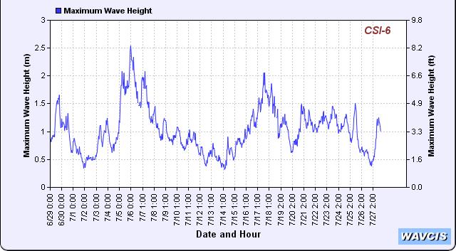
7 Sustained wind speed at station C6C for July. Data source: LSU WAVCIS, Significant wave height at station C6C for July. Data source: LSU WAVCIS, Significant wave height at station C6C for July. Data source: LSU WAVCIS,


 can escape the suffocating conditions.")
 dwellers were often sighted in the surface waters when the water below was severely depleted in oxygen.")


8 Another factor that might reduce the bottom area footprint is winds from the west (270 ± 45 ) that would push the hypoxic water mass to the east. There was evidence that this had occurred because the bottom-water hypoxia extended only to transect K and not further west. Wind direction at station C6C for July. Data source: LSU WAVCIS, Hypoxia is a recurring environmental problem in Louisiana (and sometimes Texas and Mississippi) offshore waters. Considerable effort to decrease the nutrient loading to the Mississippi River is required to reverse the widespread occurrence of hypoxia. The missing oxygen affects the behavior and mortality of animals living in the Gulf. Those that can swim away from oxygen levels less than 2 mg/l (2 ppm) can escape the suffocating conditions. However, this means that 14,000 square kilometers of Gulf bottom off Louisiana is unsuitable habitat for penaeid shrimp and demersal fishes, such as red drum, red snapper, croaker, and many others. Stressed benthic (seabed) dwellers were often sighted in the surface waters when the water below was severely depleted in oxygen. These animals included benthic burrowing eels, lesser blue crabs (Callinectes similis), small blue crabs (C. sapidus) and another swimming crab (Portunus gibbesii). Animals that cannot swim away because they live in the sediments eventually die as the oxygen falls below the level necessary to keep them alive. These animals are the crabs, starfish, brittle crabs, worms, small burrowing shrimp and many worms. Their demise eventually affects the quality of food available to fish that return to the area in the fall after hypoxia has abated. Further, low oxygen conditions have been show to affect the reproductive capacity of demersal fishes such as Atlantic croaker. For further information, contact: Dr. Nancy Rabalais, nrabalais@lumcon.edu, or Dr. Gene Turner, euturne@lsu.edu Visit the Gulf Hypoxia web site at for maps, figures, additional graphics and more information concerning this summer s research cruise, and previous cruises. NGOMEX09 funding from the National Oceanic and Atmospheric Administration, Center for Sponsored Coastal Ocean Research.
2010 DEAD ZONE ONE OF THE LARGEST EVER. 1 August 2010, from Cocodrie, Louisiana
 2010 DEAD ZONE ONE OF THE LARGEST EVER 1 August 2010, from Cocodrie, Louisiana The area of hypoxia, or low oxygen, in the northern Gulf of Mexico west of the Mississippi River delta covered 20,000 square
PRESS RELEASE. LOUISIANA UNIVERSITIES MARINE CONSORTIUM August 2, 2017 SUMMARY
 PRESS RELEASE LOUISIANA UNIVERSITIES MARINE CONSORTIUM August 2, 2017 SUMMARY The 2017 area of low oxygen, commonly known as the Dead Zone, measured 22,720 square kilometers (= 8,776 square miles) is the
PRESS RELEASE. LOUISIANA UNIVERSITIES MARINE CONSORTIUM August 4, 2013
 PRESS RELEASE LOUISIANA UNIVERSITIES MARINE CONSORTIUM August 4, 2013 The 2014 area of low oxygen, commonly known as the Dead Zone, measured 13,080 square kilometers (= 5,052 square miles) as of Aug 1,
Science of the Causes of Hypoxia Nancy Rabalais et al.
 Science of the Causes of Hypoxia Nancy Rabalais et al. In support of overview of diversions and hypoxia, and context for refining science needs; July 14, 2014 Scientific Curiosity Hypothesis Testing Management
Causes of Gulf of Mexico Hypoxia
 Causes of Gulf of Mexico Hypoxia Nancy N. Rabalais 1 R. Eugene Turner 2 1 Louisiana Universities Marine Consortium 2 Louisiana State University Center for Sponsored Coastal Ocean Research, Coastal Ocean
NGOMEX: Effects of moderate hypoxia on benthic organisms in the Gulf of Mexico
 NGOMEX: Effects of moderate hypoxia on benthic organisms in the Gulf of Mexico Ed Buskey, Laura Ryckman, Wayne Gardner and Peter Thomas Marine Science Institute The University of Texas at Austin What is
The Dead Zone. Use the notes provided (attached to this sheet) to answer the following questions.
 to answer the following questions.") The Dead Zone Use the notes provided (attached to this sheet) to answer the following questions. 1. Re-define Eutrophication: 2. What are the risks associated with an excess of Nitrogen? 3. What is a Dead
The Dead Zone Use the notes provided (attached to this sheet) to answer the following questions. 1. Re-define Eutrophication: 2. What are the risks associated with an excess of Nitrogen? 3. What is a Dead
2010 Forecast of the Summer Hypoxic Zone Size, Northern Gulf of Mexico
 2010 Forecast of the Summer Hypoxic Zone Size, Northern Gulf of Mexico Abstract As the environmental catastrophe from the Deepwater Horizon oil spill unfolds along the northern Gulf of Mexico, the persistent
Ocean Water Buoyancy and Hypoxia in the Gulf of Mexico. Definitions. Hypoxia in the Headlines. Joe Smith. ExxonMobil Upstream Research Company
 Ocean Water Buoyancy and Hypoxia in the Gulf of Mexico Joe Smith ExxonMobil Upstream Research Company Joe Smith 2004 Hypoxia NOAA Coastal Data Development Center Definitions Hypoxia is a term meaning low
Nancy Rabalais Louisiana Universities Marine Consortium
 Eutrophication, Coastal Hypoxia, Carbon & Climate Nancy Rabalais Louisiana Universities Marine Consortium nrabalais@lumcon.edu http://www.gulfhypoxia.net Charismatically stressed and dead benthic fauna
The Role of Midwestern Agriculture in Gulf of Mexico Hypoxia. Peter Scharf Nutrient Management Specialist MU Agronomy Extension
 The Role of Midwestern Agriculture in Gulf of Mexico Hypoxia Peter Scharf Nutrient Management Specialist MU Agronomy Extension What is hypoxia? Hyp = low Oxia = oxygen Hypoxia = low oxygen defined as less
Intersection of Policy & Trends: Climate, Hypoxia, and Louisiana s Coast
 Intersection of Policy & Trends: Climate, Hypoxia, and Louisiana s Coast Doug Daigle Louisiana Hypoxia Working Group Louisiana Water Conference March 27, 2018 Louisiana State University Mississippi
Hypoxia in the Gulf of Mexico: Benefits and Challenges of Using Multiple Models to Inform Management Decisions
 Hypoxia in the Gulf of Mexico: Benefits and Challenges of Using Multiple Models to Inform Management Decisions Multiple Models for Management (M3.2) in the Chesapeake Bay February 25, 2013 Annapolis MD
Overview of Gulf of Mexico Hypoxia Policy in Doug Daigle Lower Mississippi River Sub-basin Committee
 Overview of Gulf of Mexico Hypoxia Policy in 2017 Doug Daigle Lower Mississippi River Sub-basin Committee Mississippi Water Resources Conference April 12, 2017 Jackson, MS Nutrient Yields from the Mississippi
2014 Gulf of Mexico Hypoxia Forecast Donald Scavia 1, Mary Anne Evans 2, Dan Obenour 1. June 17, 2014
 2014 Gulf of Mexico Hypoxia Forecast Donald Scavia 1, Mary Anne Evans 2, Dan Obenour 1 1 University of Michgan 2 US Geological Survey Great Lakes Science Center June 17, 2014 The Gulf of Mexico annual
2013 Gulf of Mexico Hypoxia Forecast Donald Scavia 1, Mary Anne Evans 2, Dan Obenour 1. June 17, 2013, observed area added January 2, 2014
 The 2013 Forecast 2013 Gulf of Mexico Hypoxia Forecast Donald Scavia 1, Mary Anne Evans 2, Dan Obenour 1 1 University of Michgan 2 US Geological Survey Great Lakes Science Center June 17, 2013, observed
Mississippi River Water Quality: Policy, Landscapes and Hypoxia
 Mississippi River Water Quality: Policy, Landscapes and Hypoxia Dennis Keeney Distinguished Lecture R. Eugene Turner Dept. Oceanography and Coastal Studies Louisiana State University (euturne@lsu.edu)
Dead-Zones and Coastal Eutrophication: Case- Study of Chesapeake Bay W. M. Kemp University of Maryland CES Horn Point Laboratory Cambridge, MD
 Dead-Zones and Coastal Eutrophication: Case- Study of Chesapeake Bay W. M. Kemp University of Maryland CES Horn Point Laboratory Cambridge, MD Presentation to COSEE Trends Orientation at UMCES HPL 4 August
Hypoxia Effects on Demersal and Benthic Fauna
 Hypoxia Effects on Demersal and Benthic Fauna Nancy N. Rabalais 1 R. Eugene Turner 2 1 Louisiana Universities Marine Consortium 2 Louisiana State University Center for Sponsored Coastal Ocean Research,
2016 Forecast: Summer Hypoxic Zone Size Northern Gulf of Mexico R. Eugene Turner 1 and Nancy N. Rabalais 2
 2016 Hypoxia Forecast 1 2016 Forecast: Summer Hypoxic Zone Size Northern Gulf of Mexico R. Eugene Turner 1 and Nancy N. Rabalais 2 Abstract Each year a hypoxic water mass with oxygen concentrations 2 mg
Water Quality in Chandeleur Sound in 2008 and 2010
 Water Quality in Chandeleur Sound in 2008 and 2010 John Lopez, Ph.D., Andy Baker, M.Sc. Ezra Boyd, M.A. Lake Pontchartrain Basin Foundation October 10, 2010 Introduction Chandeleur Sound is the shallow-water
Water Quality Monitoring Stations
 Water Quality Monitoring Stations Eastern Basin Race Narrows Western Basin Central Basin The CT Department of Environmental Protection (CT DEP) conducts a water quality CT DEP monitoring program for the
Characterization of Hypoxia
 NOAA COASTAL OCEAN PROGRAM Decision Analysis Series No. 15 Science for Solutions Characterization of Hypoxia Topic 1 Report for the Integrated Assessment on Hypoxia in the Gulf of Mexico Nancy N. Rabalais,
Nutrient Response to Sewage Abatement in Hong Kong
 Nutrient Response to Sewage Abatement in Hong Kong Prof. Paul J. Harrison Atmospheric, Marine & Coastal Environment Program Institute for the Environment HK University of Science & Technology Outline Background
Corn Acreage, Fertilizer Use, & Spring Nutrient Discharge in the Mississippi River Basin: Relationships & Impact on Hypoxia
 Corn Acreage, Fertilizer Use, & Spring Nutrient Discharge in the Mississippi River Basin: Relationships & Impact on Hypoxia C.S. Snyder, PhD, CCA Nitrogen Program Director Northern Gulf of Mexico Hypoxia:
GLOBAL WARMING LEADS TO UNDERWATER DESERTS" AND COASTAL DEAD ZONES
 GLOBAL WARMING LEADS TO UNDERWATER DESERTS" AND COASTAL DEAD ZONES Suhas E.P RVCE (VTU) No. 4/1 Golden Residency, Rmv 2 stage, Sanjaynagar, Bangalore SYNOPSIS Oxygen-poor waters occupy large volumes of
NUTRIENT THE OHIO RIVER
 NUTRIENT MANAGEMENT FOR THE OHIO RIVER Why nutrient management is necessary Nutrients are necessary for a healthy aquatic community, but Excessive quantities of nutrients can have negative effects Negative
Dead Zones for Dinner
 STUDENT READING DEAD ZONES AND EUTROPHICATION: HOW FOOD WE EAT IS CONNECTED TO WATER POLLUTION Introduction Imagine scuba diving in an aquatic environment where life abounds--a place whose biological diversity
Hobcaw Barony and the USC Baruch Marine Field Laboratory
 Hobcaw Barony and the USC Baruch Marine Field Laboratory James L. Pinckney Marine Science Program and Department of Biological Sciences School of the Earth, Ocean, and Environment University of South Carolina
Nutrients, Algal Blooms and Red Tides in Hong Kong Waters. Paul J. Harrison and Jie XU
 Nutrients, Algal Blooms and Red Tides in Hong Kong Waters Paul J. Harrison and Jie XU Division of Environment, Hong Kong University of Science & Technology 1. Introduction The Pearl River is China's second
of Hypoxia in the Northern Gulf of Mexico
 of Hypoxia in the Northern Gulf of Mexico hile information gaps still exist and several factors discussed below may contribute to hypoxia, the overwhelming scientific evidence indicates that excess nitrogen
The Hypoxic Zone in the Gulf of Mexico
 The Hypoxic Zone in the Gulf of Mexico References Council Committee on Environmental and Natural Resources. 2003. An Assessment of Coastal Hypoxia and Eutrophication in U.S. Water. National Science and
SECTION 1 FRESHWATER SYSTEMS UNIT 4: AQUATIC ECOLOGY
 SECTION 1 FRESHWATER SYSTEMS UNIT 4: AQUATIC ECOLOGY CENTRAL CASE STUDY: STARVING THE LOUISIANA COAST OF SEDIMENT LOUISIANA IS LOSING 25MI2 OF COASTAL WETLANDS ANNUALLY WETLANDS SUPPORT A DIVERSITY OF
Time-series and Underway Assessments of Ocean Acidification and Carbon System Properties in Coastal Waters
 NGI Annual Meeting 2012 Time-series and Underway Assessments of Ocean Acidification and Carbon System Properties in Coastal Waters Wei-Jun Cai, Xinping Hu, Scott Noakes, Joe Salisbury, Doug Vandemark,
Chesapeake Bay. report card
 Chesapeake Bay report card 2010 C- C Healthy water quality provides better habitat conditions for crabs, fish, and other aquatic species. issolved oxygen is essential to the survival of all these organisms;
Reducing Hypoxia in the Gulf of Mexico: Advice from Three Models
 Estuaries Vol. 27, No. 3, p. 419 425 June 2004 Reducing Hypoxia in the Gulf of Mexico: Advice from Three Models DONALD SCAVIA 1,, *, DUBRAVKO JUSTIĆ 2, and VICTOR J. BIERMAN, JR. 3 1 National Oceanic and
Mid-Bay Dissolved Oxygen Trends as a. Function of Nutrient Loads and Strength of Stratification
 Mid-Bay Dissolved Oxygen Trends as a William P. Ball 1, Damian C. Brady 3, Dominic D. DiToro 4, W. Michael Kemp 2, Rebecca R. Murphy 1, Jeremy M. Testa 2 (and others) 1 Dept. of Geography and Environmental
HYPOXIA ACTION PLAN: WHAT CAN MIDWEST AGRICULTURE DO? Dennis McKenna Illinois Department of Agriculture
 HYPOXIA ACTION PLAN: WHAT CAN MIDWEST AGRICULTURE DO? Dennis McKenna Illinois Department of Agriculture The hypoxic zone is an area in the northern Gulf of Mexico where dissolved oxygen concentrations
Fig. 1. Map for location
 The Asian Journal of Biology Education (2002) Number 1 3 Faculty of Education, Shiga University 2--1 Hiratsu, Otsu, 20-0862. Japan. Introduction Lake Biwa (Fig. 1) is the largest lake in Japan and one
Using the Chesapeake Bay Program Interpolator to analyze Chesapeake Bay monitoring program data
 Using the Chesapeake Bay Program Interpolator to analyze Chesapeake Bay monitoring program data Bill Romano & Mark Trice MD Dept. of Natural Resources bromano@dnr.state.md.us mtrice@dnr.state.md.us www.eyesonthebay.net
Gulf of Mexico Hypoxia Monitoring Implementation Plan. Alan Lewitus NOAA/NOS/NCCOS Center for Sponsored Coastal Ocean Research
 Gulf of Mexico Hypoxia Monitoring Implementation Plan Alan Lewitus NOAA/NOS/NCCOS Center for Sponsored Coastal Ocean Research GCOOS Board of Directors Meeting 19 Aug 2008 Management Driver: Action Plans
ONLINE SUPPORTING MATERIAL
 ONLINE SUPPORTING MATERIAL for the paper bg-22-78: Simulating the effects of phosphorus limitation in the Mississippi and Atchafalaya River plumes by A. Laurent, K. Fennel, J. Hu and R. Hetland. 5 Patterns
Characterization of Hypoxia
 NOAA COASTAL OCEAN PROGRAM Decision Analysis Series No. 15 Science for Solutions Characterization of Hypoxia Topic 1 Report for the Integrated Assessment on Hypoxia in the Gulf of Mexico Nancy N. Rabalais,
Mississippi River/Gulf of Mexico Watershed Nutrient Task Force Timeline for Reassessment Revised 9/5/06. Revised 9/5/06. Symposia.
 Hypoxia in the Gulf of Mexico Extent of Hypoxia in the Gulf Reassessment of the Science & Revision of the Action Plan Frequency of Occurrence 1985-1999 Rabalais, et al. Summer Hypoxia Dissolved Oxygen
Low Dissolved Oxygen HYPOXIA. What is Hypoxia?
 HYPOXIA Low Dissolved Oxygen What is Hypoxia? Hypoxia or low dissolved oxygen has been identified as the most critical issue facing the Sound. Just as we breathe oxygen, the fish and other marine life
Global Warming leads to Underwater Deserts. SUHAS.E.P I Year.Dept of Mechanical engineering RVCE
 Global Warming leads to Underwater Deserts SUHAS.E.P I Year.Dept of Mechanical engineering RVCE Introduction Oxygen-poor waters occupy large volumes of the intermediate-depth eastern tropical oceans. Oxygen-poor
HYPOXIA Definition: ~63 µm; 2 mg l -1 ; 1.4 ml l -1 ; 30 %
 HYPOXIA Definition: ~63 µm; 2 mg l -1 ; 1.4 ml l -1 ; 30 % Consequences of hypoxia Reduce habitat for living resources Change biogeochemical processes P released from sediments Denitrification reduced
Science to Improve Management of the Gulf of Mexico Hypoxic Zone: A Collaborative Approach
 Science to Improve Management of the Gulf of Mexico Hypoxic Zone: A Collaborative Approach Alan Lewitus, David Kidwell, and Libby Jewett Center for Sponsored Coastal Ocean Research National Oceanic and
NOAA NGOMEX Program Management Science Needs
 NOAA NGOMEX Program Management Science Needs Alan Lewitus and David Hilmer NOAA National Ocean Service National Centers for Coastal Ocean Science Hypoxia Effects on Fish and Fisheries Workshop/Gulf of
CBF Water Quality Interactive Map
 CBF Water Quality Interactive Map Student and adult groups that take part Often, they measure the water chemistry to evaluate the be doing it when you come out with us! By compiling these points on a map
Production vs Biomass
 Patterns of Productivity OCN 201 Biology Lecture 5 Production vs Biomass Biomass = amount of carbon per unit area (= standing stock * C/cell) Units (e.g.): g C m -2 Primary Production = amount of carbon
Offshore petroleum platforms and dissolved oxygen in the northern Gulf of Mexico Key words Introduction
 Offshore petroleum platforms and dissolved oxygen in the northern Gulf of Mexico Derek G. Bolser Term Paper for Geographic Information Systems in Water Resources, Fall 2016 Key words: Gulf of Mexico, hypoxia,
Ch. 7 Aquatic Ecology
 Ch. 7 Aquatic Ecology 1.Coral Reefs: the aquatic equal to the tropical rain forests 2.The two major aquatic life zones A. saltwater or marine (estuaries, coastlines, coral reefs, coastal marshes, mangrove
Implications of global climate change for estuarine & coastal ecosystems (Gulf of Mexico in particular)
") - The cumulative effects of global change, including climate change, increased population, & more intense industrialization & agribusiness, will likely continue & intensify the course of eutrophication
- The cumulative effects of global change, including climate change, increased population, & more intense industrialization & agribusiness, will likely continue & intensify the course of eutrophication
Ecology Chapter 11: Marine
 Ecology Chapter 11: Marine 1 I. Oceans made up of all waters between continents The World Ocean because waters are interconnected can be thought of as one large biome with many different ecosystems and
Chapter 6. Aquatic Biodiversity. Chapter Overview Questions
 Chapter 6 Aquatic Biodiversity Chapter Overview Questions Ø What are the basic types of aquatic life zones and what factors influence the kinds of life they contain? Ø What are the major types of saltwater
Little Bay Water Quality Report Card Spring 2014
 Little Bay Water Quality Report Card Spring 2014 Little Bay is a small, semi-enclosed estuary located in the heart of Rockport, Texas. Estuaries, where freshwater from rivers and streams mixes with salt
Modeling Coastal Hypoxia: Lessons learned and perspectives for the future Part 1
 Modeling Coastal Hypoxia: Lessons learned and perspectives for the future Part 1 R. Eugene Turner 1 Dubravko Justi 1 and Nancy N. Rabalais 2 1 Louisiana State University, USA 2 Louisiana Universities Marine
STAAR Science Tutorial 55 TEK 8.11D: Human Dependence on Ocean Systems
 Name: Teacher: Pd. Date: STAAR Science Tutorial 55 TEK 8.11D: Human Dependence on Ocean Systems TEK 8.11D: Recognize human dependence on ocean systems and explain how human activities such as runoff, artificial
Nutrient Sources, Fate, Transport, and Effects Study of Galveston Bay, Texas Rachel Windham,
 Nutrient Sources, Fate, Transport, and Effects Study of Galveston Bay, Texas Rachel Windham, Department of Marine Biology Texas A&M University at Galveston 2 Acknowledgements: Dr. Antonietta Quigg Members
Part I: Salish Sea Introduction. Review:
 Part I: Salish Sea Introduction Review: The Salish Sea The Salish Sea was formed about 20,000 years ago during the last ice age by the carving action of glaciers. There are 3 major parts of the Salish
Dog River Watershed Management Plan
 Dog River Watershed Management Plan Preliminary Water Quality Data Analysis Doug Robison, PWS ESA is where solutions and service meet. Water Quality - Regulatory Primer Designated Use Categories Swimming
Coastal Ecosystems: Saving Chesapeake Bay. Note the highest pigment concentrations (red) in coastal regions, especially estuaries
 in coastal regions, especially estuaries") Coastal Ecosystems: Saving Chesapeake Bay Note the highest pigment concentrations (red) in coastal regions, especially estuaries Coastal Ecosystems: human impacts Humans severely impact the coastal zone
Coastal Ecosystems: Saving Chesapeake Bay Note the highest pigment concentrations (red) in coastal regions, especially estuaries Coastal Ecosystems: human impacts Humans severely impact the coastal zone
Hypoxia in the Northern Gulf of Mexico: Does the Science Support the Plan to Reduce, Mitigate, and Control Hypoxia?
 Estuaries and Coasts Vol. 30, No. 5, p. 753 772 October 2007 Hypoxia in the Northern Gulf of Mexico: Does the Science Support the Plan to Reduce, Mitigate, and Control Hypoxia? N. N. RABALAIS 1, *, R.
Linking the Coastal Salinity Index with Freshwater Inflows to Characterize Salinity Variability in Gulf of Mexico Estuaries
 Linking the Coastal Salinity Index with Freshwater Inflows to Characterize Salinity Variability in Gulf of Mexico Estuaries Christopher Swarzenski, Kirk Rodgers, Lower Mississippi Gulf Water Science Center
Chemical and Physical Analysis of the Cape Fear Estuary
 The Cape Fear River Chemical and Physical Analysis of the Cape Fear Estuary The Cape Fear River (CFR), the most industrialized of all North Carolina s rivers, winds for over miles through the heart of
Little Cypress Bayou Special Study - Subwatershed 1.10
 - Subwatershed 1.1 Sabine River Authority of Texas August 31, 21 Prepared in Cooperation with the Texas Natural Resource Conservation Commission Under the Authorization of the Texas Clean Rivers Act Table
Effects of Winds on Hypoxia Formation in the Pearl River Estuarine Coastal Waters
 The 1th International Estuarine Biogeochemistry Symposium May 19-22, 28, Xiamen China Effects of Winds on Hypoxia Formation in the Pearl River Estuarine Coastal Waters Kedong YIN 1,2,3, Paul J. Harrison
Patterns of Productivity
 Patterns of Productivity OCN 201 Biology Lecture 8 Primary Production - the production of autotrophic biomass Secondary Production - the production of heterotrophic biomass Production vs Biomass Biomass
Nutrient distributions and the interaction between coastal wetlands and the nearshore of Lake Ontario
 Nutrient distributions and the interaction between coastal wetlands and the nearshore of Ontario Krista Chomicki and Gary Bowen International Association of Great s Research, 25 Type Durham Region Coastal
The Complex Impacts of Rivers on Coastal and Continental Shelf Environments
 The Complex Impacts of Rivers on Coastal and Continental Shelf Environments L. Donelson Wright Professor Emeritus, Virginia Institute of Marine Science September 6, 2007 At the most basic level, river-ocean
Stratified Receiving Waters. Receiving Water Types
 Stratified Receiving Waters Environmental Hydraulics Receiving Water Types flowing water shallow lakes (depth < 12 15 m) deep lakes (depth > 12 15 m) estuaries open coastal areas SNV: Swedish EPA Stratified
Joint Cruise Methodology
 Joint Cruise Methodology Alexander Mikaelyan & Tamara Shiganova Batumi, 22 May The main goal of the Joint Cruises To provide ecosystem monitoring of the open waters of the Black Sea on inter-annual and
Documenting the Cause of a Fish Kill on the Neuse River Estuary
 Documenting the Cause of a Fish Kill on the Neuse River Estuary On October 23, 2006, a resident living on Upper Broad Creek noticed fish gulping for air at the surface. The next day, October 24 th, the
Continued from Lecture 20a
 IV. Primary Production (p.p.) Continued from Lecture 20a C. Biomass & Productivity 1. Biomass = mass of organic matter (in grams) a. Gross primary production = total amount of organic material synthesized
Future climate scenarios for phosphorus and nitrogen dynamics in the Gulf of Riga
 Future climate scenarios for phosphorus and nitrogen dynamics in the Gulf of Riga Bärbel Müller Karulis, Latvian Institute of Aquatic Ecology Juris Aigars, Latvian Institute of Aquatic Ecology In colaboration
Water Monitoring in Spa Creek: A Summary
 Water Monitoring in Spa Creek: A Summary Written by: Alexis Jones & Blake Harden Edited by: Hannah Krauss Water monitoring is very important in order to determine the health of the Chesapeake Bay and its
Water Supply Discussion - Demands Inflows/Pass-Thru Requirements of Agreed Order. Council Presentation August 30, 2016
 Water Supply Discussion - Demands Inflows/Pass-Thru Requirements of Agreed Order Council Presentation August 30, 2016 1 Today s Presentation Alternative Demand Projection Kristi Shaw (HDR) Fresh Water
A Method For Managing Freshwater Inflows To Estuaries
 A Method For Managing Freshwater Inflows To Estuaries Stephen B. Olsen Coastal Resources Center University of Rhode Island Woodrow Wilson Center Washington D.C. December 7, 2006 The Integrated Management
THE CHALLENGE OF NUTRIENT CONTROL IN LARGE SCALE WATERSHEDS: EFFORTS IN THE U.S.
 THE CHALLENGE OF NUTRIENT CONTROL IN LARGE SCALE WATERSHEDS: EFFORTS IN THE U.S. NAE Convocation of the Professional Engineering Societies David Dzombak Carnegie Mellon University May 16, 2011 OUTLINE
SCIENCE GRADES 5-8 JANIECE MISTICH LEARNING OBJECTIVES:
 HYPOXIA AND THE DEAD ZONE IN THE GULF OF MEXICO: IS IT THE MISSISSIPPI RIVER S FAULT? TIME ALLOTMENT: Introductory Activity: 20 minutes Learning Activity: Two 50 minute periods Culminating Activity #1:
Columbia River Plume correlation with Oregon/Washington dead zones
 Columbia River Plume correlation with Oregon/Washington dead zones The location of the Oregon and Washington dead zones strongly correlate with Columbia River Plum summer flow patterns. OSU map OSU Map
Freshwater ecosystems
 Aquatic Ecosystems Aquatic Ecosystems The types of organisms in an aquatic ecosystem are determined by the water s salinity. Salinity - Amount of salt in the water. Freshwater ecosystems do not have any
Predicting the response of Gulf of Mexico hypoxia to variations in Mississippi River nitrogen load
 May 2003 Volume 48 Number 3 Limnol. Oceanogr., 48(3), 2003, 951 956 2003, by the American Society of Limnology and Oceanography, Inc. Predicting the response of Gulf of Mexico hypoxia to variations in
Water intake for hatchery on Chattahoochee River
 Lake Lanier Turnover Facts Buford Trout Hatchery gets the water used to grow trout from the tailwater area of the Chattahoochee River immediately below Lake Lanier. Natural processes occurring in the lake
The Lower Galveston Bay Watershed: Potential Oil Spill Impacts
 The Lower Galveston Bay Watershed: Potential Oil Spill Impacts Lisa Gonzalez Jim Lester Houston Advanced Research Center July 13, 2010 Oil Near Mississippi Delta, July 4 Source: NASA MODIS Local Perspective
BIOLOGY TERC.UCDAVIS.EDU
 10 Algae growth (primary productivity) Yearly since 1959 Primary productivity is a measure of the rate at which algae produce biomass through photosynthesis. It was first measured at Lake Tahoe in 1959
Productivity and fisheries. Energy flow. Biological pyramids. Why study production processes?
 Productivity and fisheries Why study production processes? Fisheries strongly tied to spatial and temporal variation in primary productivity Better understanding of distribution of fishery resources Interpret
Ecology. Climate. Global Climate. Chapter 52: Introduction to Ecology and the Biosphere
 Chapter 52: Introduction to Ecology and the Biosphere Ecology oikos - home! logos - to study! Ecology - the study of interactions between organisms and the environment! Answer important questions:! Where
2017 Hypoxic Zone Conditions: Monitoring and Modeling Results
 2017 Hypoxic Zone Conditions: Monitoring and Modeling Results Alan Lewitus, Trevor Meckley, and David Scheurer NOAA National Ocean Service National Centers for Coastal Ocean Science Hypoxia Task Force
WATER QUALITY MONITORING PROJECT FOR DEMONSTRATION OF CANAL REMEDIATION METHODS FLORIDA KEYS. Report of activities: September 7th, 2016
 Southeast Environmental Research Center WATER QUALITY MONITORING PROJECT FOR DEMONSTRATION OF CANAL REMEDIATION METHODS FLORIDA KEYS Report of activities: September 7th, 2016 Presented to: Florida Keys
AGENDA CHANNEL ISLANDS HARBOR TASK FORCE SPECIAL MEETING
 A. Roll Call B. Pledge of Allegiance C. New Business AGENDA CHANNEL ISLANDS HARBOR TASK FORCE SPECIAL MEETING Monday, October 22, 2018, 6:00pm Performing Arts Center, Ventura Room 800 Hobson Way, Oxnard,
CTD (CONDUCTIVITY-TEMPERATURE-DEPTH)
") CTD (CONDUCTIVITY-TEMPERATURE-DEPTH) Related lesson plan Fresh and Seawater Density What is this sensor? CTD is an acronym for Conductivity, Temperature and Depth. However, this is somewhat misleading
CTD (CONDUCTIVITY-TEMPERATURE-DEPTH) Related lesson plan Fresh and Seawater Density What is this sensor? CTD is an acronym for Conductivity, Temperature and Depth. However, this is somewhat misleading
Environmental Health Perspectives Volume 108, Number 3, March 2000
 Environmental Health Perspectives Volume 108, Number 3, March 2000 Since the 1970s, studies have documented that during the warm months oxygen levels in the Mississippi plume region of the Gulf of Mexico
Hudson River Estuary Climate Change Lesson Project. Grades 5-8 Teacher s Packet. Lesson 8. Carbon Through the Seasons
 Grades 5-8 Teacher s Packet Lesson 8 Carbon Through the Seasons Teacher s Packet 2 Carbon Through the Seasons NYS Intermediate Level Science Standard 1: Analysis, Inquiry and Design/Scientific Inquiry
eutrophication: an increase in the rate of supply of organic matter to an ecosystem.
 Appendix 55 Glossary algae: a group of chiefly aquatic plants (e.g., seaweed, pond scum, stonewort, phytoplankton) that contain chlorophyll and may passively drift, weakly swim, grow on a substrate, or
SYNERGISTIC PROJECT Using Linked Models to Predict the Impacts of Hypoxia on Gulf Coast Fisheries under Scenarios of Watershed and River Management
 SYNERGISTIC PROJECT Using Linked Models to Predict the Impacts of Hypoxia on Gulf Coast Fisheries under Scenarios of Watershed and River Management Kenneth Rose 1 LSU Workshop: Hypoxia effects on fish
When Things Heat Up. To relate the physical and chemical properties of water to a water pollution issue.
 Purpose: Summary: To relate the physical and chemical properties of water to a water pollution issue. In this exercise, students will measure the temperature and dissolved oxygen of a stream (or use their