K.Sangeetha, B.Narasimhan Department of Civil Engineering, Indian Institute of Technology, Madras
|
|
|
- Arron Roberts
- 5 years ago
- Views:
Transcription

1 Analytic Element Method (AEM) and its Relevance with Subbasin/HRU concept of SWAT for potential integration of AEM based simple ground water model K.Sangeetha, B.Narasimhan Department of Civil Engineering, Indian Institute of Technology, Madras
2 Outline Introduction SWAT GW Model Need for study Solution methods for solving GW flow problems Analytic Element Method and its Assumptions Principle of superposition Types and representation of Analytic Elements Methodology Example Advantages and limitations of AEM Applications of AEM 2
3 Introduction Streams and Lakes interact with adjacent aquifers, creating complex flow paths in hydrologic cycle. Better quantification of water balance components and improved characterization of surface (SW) and ground water (GW) interaction help in improving water resource management Several numerical models (FDM/FEM) for ground water modelling is used and coupled with SW model for understanding the SW-GW Interaction. This study attempts to integrate Soil and Water Assessment Tool (SWAT) with Analytic Element Method (AEM) for ground water modelling 3
4 SWAT Ground Water component Precipitation Plant Transpiration Soil Evaporation Surface Runoff Soil Profile Sub Surface Lateral flow Shallow Aquifer Reva p Percolation/GW Recharge GW Flow Source: Vazquez-Amábile and Engel (2005) Deep Aquifer Percolation 4


5 Limitations of SWAT GW model SWAT considers each HRU and subbasins as separate 1-D unit - interactions between them is not considered Spatial locations of each HRU - subbasins are not considered Lacks in simulating the distribution and dynamics of GW levels and recharge rates for watersheds 5

6 Need for this study Conjunctive use of SW-GW resources SW and GW interconnected Studies are limited in Coupling SW-GW systems SWAT coupled with AEM based GW model Source: Dudley & Fulton (2005) 6
,Finite Element Method (FEM) Each solves the governing equation of GW flow and storage in a different approaches.")
7 Solution Methods for Solving Ground Water Flow Problems In order of increasing Complexity : o o o Analytical Solutions : h=f(x,y,z,t) Eg : Theis Equation Analytic Element Method (AEM) Numerical solutions : Finite Difference Method (FDM),Finite Element Method (FEM) Each solves the governing equation of GW flow and storage in a different approaches. The assumptions and applicablility of the methods differs. 7
8 Analytic Element Method (AEM) AEM (Analytic Element method) - proposed by Otto Strack potential theory AEM works on superposition of analytic functions called as analytic elements within a grid independent domain Each function (elements) can be modelled individually and super imposed based on linearity of laplace equation to obtain full description of the aquifer. Appropriately choosing discharge potentials, rather than piezometric heads, the AEM becomes applicable to both confined and unconfined flow conditions as well as to heterogeneous aquifers 12 July
9 How does principle of superposition work? 12 July 2017 e.g.theis Solution 9
10 Type and Representation of Analytic Elements Area Element (Uniform Recharge) Area Element (Lake) Point Element (Well in uniform flow) Line Element (River) 10
11 Principle of Superposition in 1D plane Consider GW flow in an infinite strip to a horizontal equipotential Thickness : H Length of Streambed L Two sections of constant recharge : Recharge strip to left N1 and right N2 Figure : SW-GW interactions in the vertical plane x= -, Uniform specific discharge = Q L /H and x=, Uniform specific discharge = Q R /H 12 July
 12")

12 (Contd..) 12 July
13 Point Source/Sink (Well Element) Withdraw/supply water Input : Q, R and its location, Extraction or injection (well) rate Losing Streams : Radius (+),discharge (-) ; vice versa for gaining streams Dirichlet, Neumann Boundary Condition used Φ =RΩ = ;Ψ = IΩ = = 13
14 Line Source/Sink (Streams) Infinite number of point sinks (wells) along a straight line Inject or extract a net amount of water from the aquifer Losing streams : line sink with a negative sink density ; vice versa for gaining streams Input : Head at beginning and end of a line segment, the resistance, the depth and the width of the river, SW head condition (stage), bottom elevation, width and conductance of underlying bed material 14
15 (Contd..) Z = Φ =RΩ = Ψ = IΩ = (Eg: Along the X axis and Y=0) 15
16 Area Source/Sink Analytic, non-harmonic functions utilized for representing extraction or infiltration over the area bounded by polygons By Combination Of Distributed Doublets And Distributed Line Sinks Input : location of the lake boundary, uniform recharge/leakage 16


17 Complex potential, Boundary conditions and the solution 12 July
 ZZZZ ΦΦΦΦ = (kk(zz)( zz)dddd) ZZZZ ΦΦ = 11 22 kkhh22 = 11 22 kk (φφ)22, ϕ H ΦΦ = kkkk(φφ) 11 22 kkhh22 ϕ H")
18 (Contd..) ZZZZ ΦΦΦΦ = (kk(zz)( zz)dddd) ZZZZ ΦΦ = kkhh22 = kk (φφ)22, ϕ H ΦΦ = kkkk(φφ) kkhh22 ϕ H Examples : No flow condition, uniform flow condition, Vertical inflow of water in an infinite aquifer 12 July
19 Applications of AEM Where there exists many surface water features or other structures (wells) influence/determine the GW flow over the AOI/ joint effects with corresponding elements Sharp variation in the GW levels, Eg : around wells or well field as the method can model both local and regional effects rather accurately Well head and capture zone delineation Local and Regional GW modelling 12 July
20 Input data to AEM Base Elevation - Soil borings Thickness of aquifer - Soil borings Hydraulic conductivity Pump test, slug test Porosity from literature Boundary conditions 20


21 SWAT Input to AEM Input HRU will be treated as Area Element Well will be treated as Point Element River will be treated as Line Element 12 July
 Point Element (Well in uniform flow) Line Element")
22 Example in VISUAL AEM Area Element (Uniform Recharge; HRU) Area Element (Lake) Point Element (Well in uniform flow) Line Element (River) 22

23 Step 1 : Enter Aquifer Properties 23

24 Step 2 : Enter Boundary Conditions 24

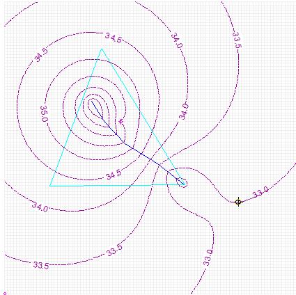
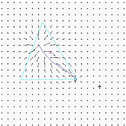
25 Well Element Step 3 : Element Generation Input : Extraction Well Discharge : 50 m 3 /d Well radius :0.1 m Well location : x = y =
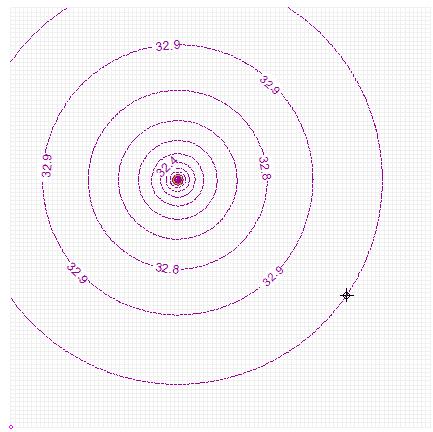
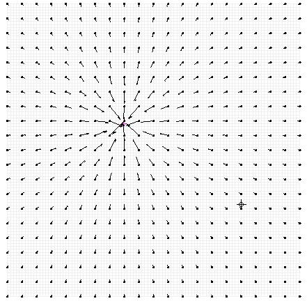
26 Head Distribution and Flow vectors Φ Ψ 26

27 (Contd..) Line Element Input : Head Specified B.C ID X Y Head (m)
28 Head Distribution and Flow vectors Φ Ψ 28
 Area Element Input :")
29 (Contd..) Area Element Input : Uniform Recharge: m/d 29
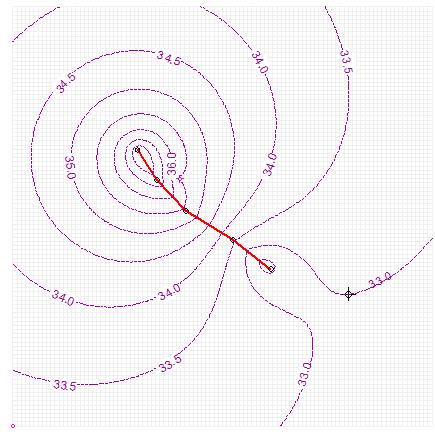
30 Head Distribution and Flow vectors Φ Ψ 30
31 (Contd..) Area Element -Lake Input : Elevation specified lake Lake elevation : 42 m 31
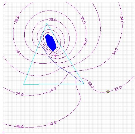
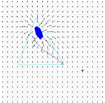
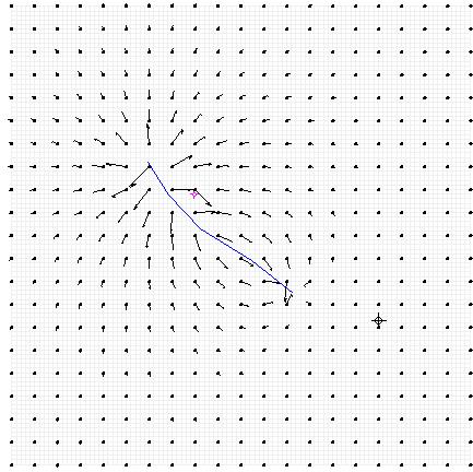
32 Head Distribution and Flow vectors Φ Ψ 32


33 Head Distribution and Flow vectors in NO FLOW boundary Φ Ψ 33
34 Methodology Integrated SW & GW Model for water resource Assessment SWAT SW hydrology Model AEM based GW hydrology model Data: DEM, LULC, Soil, Hydro- Meteorological data Data: DEM, Surface water features, Ground water levels, and Aquifer properties of HRU Import the input data such as DEM, Surface water features to the model Simulate SWAT overland and channel processes Recharge/ Pumping rate of HRU AEM based GW Model Convert the surface water features from DEM to shape files Compute Base flow and GW height for analytic elements Select the important surface water features manually by hand digitizing the map Input computed Base flow from AEM to SWAT NO YES Check for convergence at far field Base flow & GW height Convert the surface water features to Analytic Elements (Points, Lines, and Polygons) Develop the boundary conditions based on element geometry, type of BC, BC parameters and the analytic function used for BC Flow Hydrograph
35 Advantages of AEM Scale Independence Absence of grid Flexibility in model domain Computational time and less storage capacity requirement No need of any conversion for running the GW model Better Solution solvers and matrix schemes compared to FDM/FEM methods Continuity of flow is assured -the heads and GW velocities computed by continuous space at any point in the flow domain 35
36 Limitations of AEM Steady state, limited models developed for transient conditions Two dimensional Horizontal layers with constant thickness Homogeneity, isotropic soil Applicable when the equations are linear No vertical recharge from infiltration or leakage 36
Comparative analysis of SWAT model with Coupled SWAT-MODFLOW model for Gibbs Farm Watershed in Georgia
 2018 SWAT INTERNATIONAL CONFERENCE, JAN 10-12, CHENNAI 1 Comparative analysis of SWAT model with Coupled SWAT-MODFLOW model for Gibbs Farm Watershed in Georgia Presented By K.Sangeetha B.Narasimhan D.D.Bosch
GROUNDWATER Dr. DEEPAK KHARE GENERAL HYDROLOGY CYCLE FORMATIONS
 GROUNDWATER By Dr. DEEPAK KHARE Associate Professor Department of Water Resources Development & Management Indian Institute of Technology Roorkee, ROORKEE (Uttaranchal) 247 667, India E-mail: kharefwt@iitr.ernet.in
SEES 503 SUSTAINABLE WATER RESOURCES GROUNDWATER. Instructor. Assist. Prof. Dr. Bertuğ Akıntuğ
 SEES 503 SUSTAINABLE WATER RESOURCES GROUNDWATER Instructor Assist. Prof. Dr. Bertuğ Akıntuğ Civil Engineering Program Middle East Technical University Northern Cyprus Campus SEES 503 Sustainable Water
Well Hydraulics. The time required to reach steady state depends on S(torativity) T(ransmissivity) BC(boundary conditions) and Q(pumping rate).
 T(ransmissivity) BC(boundary conditions) and Q(pumping rate).") Well Hydraulics The time required to reach steady state depends on S(torativity) T(ransmissivity) BC(boundary conditions) and Q(pumping rate). cone of depression static water level (SWL) drawdown residual
Well Hydraulics The time required to reach steady state depends on S(torativity) T(ransmissivity) BC(boundary conditions) and Q(pumping rate). cone of depression static water level (SWL) drawdown residual
4.4 MODEL CODE DESCRIPTION 4.5 WATER SOURCES AND SINKS 4.6 MODEL DOMAIN AND BOUNDARIES. SLR South Africa
 Page 4-18 The developed model should therefore be seen as an initial site model which should be refined and recalibrated once more groundwater monitoring and other data become available. 4.4 MODEL CODE
Scale Effects in Large Scale Watershed Modeling
 Scale Effects in Large Scale Watershed Modeling Mustafa M. Aral and Orhan Gunduz Multimedia Environmental Simulations Laboratory School of Civil and Environmental Engineering Georgia Institute of Technology
 5. MODEL DESCRIPTION Several models were used in combination to estimate the impacts of the proposed 100,000 acre-ft dryyear yield program. MODFLOW and MODPATH were used to estimate the groundwater and
Groundwater Modeling Guidance
 Groundwater Modeling Guidance Richard J. Mandle Groundwater Modeling Program Michigan Department of Environmental Quality Draft 1.0 10/16/02 Executive Summary The use of groundwater models is prevalent
SOURCES OF WATER SUPPLY GROUND WATER HYDRAULICS
 SOURCES OF WATER SUPPLY GROUND WATER HYDRAULICS, Zerihun Alemayehu GROUNDWATER Groundwater takes 0.6% of the total water in the hydrosphere 0.31% of the total water in the hydrosphere has depth less than
Predicting Groundwater Sustainability: What Tools, Models and Data are Available?
 Predicting Groundwater Sustainability: What Tools, Models and Data are Available? Ray Wuolo Barr Engineering Company Assessing Sustainability is All About: Predicting (or describing) how potentiometric
2
 1 2 3 4 5 6 The program is designed for surface water hydrology simulation. It includes components for representing precipitation, evaporation, and snowmelt; the atmospheric conditions over a watershed.
FLOW NETS. 1. Determine the directions of groundwater flow using flow nets.
 9-12 FLOW NETS SUBJECTS: TIME: Science (Physical Science), Social Studies (Economics, Political Science) 1 class period MATERIALS: Copies of background information Student sheets OBJECTIVES The student
CHAPTER 7 GROUNDWATER FLOW MODELING
 148 CHAPTER 7 GROUNDWATER FLOW MODELING 7.1 GENERAL In reality, it is not possible to see into the sub-surface and observe the geological structure and the groundwater flow processes. It is for this reason
Effect of Conjunctive Use of Water for Paddy Field Irrigation on Groundwater Budget in an Alluvial Fan ABSTRACT
 1 Effect of Conjunctive Use of Water for Paddy Field Irrigation on Groundwater Budget in an Alluvial Fan Ali M. Elhassan (1), A. Goto (2), M. Mizutani (2) (1) New Mexico Interstate Stream Commission, P.
Hydrology and Water Resources Engineering
 Hydrology and Water Resources Engineering SUB GSttingen 214 868 613 K.C. Patra 't'v Mai Narosa Publishing House New Delhi Chennai Mumbai Calcutta CONTENTS Preface vii 1. Introduction 1 1.1 General 1 1.2
Ground Water Issues of the South Platte River Basin. Presented by: James L. Jehn, C.P.G. Jehn Water Consultants, Inc.
 Ground Water Issues of the South Platte River Basin Presented by: James L. Jehn, C.P.G. Jehn Water Consultants, Inc. Ground Water Wells South Platte Alluvial Wells Approx. 10,000 Alluvial Wells in the
Introduction to Land Surface Modeling Hydrology. Mark Decker
 Introduction to Land Surface Modeling Hydrology Mark Decker (m.decker@unsw.edu.au) 1) Definitions 2) LSMs 3) Soil Moisture 4) Horizontal Fluxes 5) Groundwater 6) Routing Outline 1) Overview & definitions
Groundwater Level and Movement
 Groundwater Level and Movement Infiltration and Recharge Infiltration Entry of rain water into the ground. Recharge Addition of infiltrated water to the aquifer. Two types of Recharge- 1. Natural 2. Artificial
University of Arizona Department of Hydrology and Water Resources Dr. Marek Zreda. HWR431/531 - Hydrogeology Problem set #1 9 September 1998
 University of Arizona Department of Hydrology and Water Resources Dr. Marek Zreda HWR431/531 - Hydrogeology Problem set #1 9 September 1998 Problem 1. Read: Chapter 1 in Freeze & Cherry, 1979. McGuiness
WELLHEAD PROTECTION DELINEATION REPORT FOR THE VILLAGE OF BEAR LAKE DECEMBER 2002
 WELLHEAD PROTECTION DELINEATION REPORT FOR THE VILLAGE OF BEAR LAKE DECEMBER 2002 Prepared by: Gosling Czubak Engineering Sciences, Inc. 1280 Business Park Drive Traverse City, Michigan 48686 Telephone:
8. Regional groundwater system
 8. Regional groundwater system 8-1 We have learned basic principles governing the flow and storage of groundwater. We will now use these principles to understand groundwater in the regional context. Flow
The Texas A&M University and U.S. Bureau of Reclamation Hydrologic Modeling Inventory (HMI) Questionnaire
 Questionnaire") The Texas A&M University and U.S. Bureau of Reclamation Hydrologic Modeling Inventory (HMI) Questionnaire May 4, 2010 Name of Model, Date, Version Number Dynamic Watershed Simulation Model (DWSM) 2002
The Texas A&M University and U.S. Bureau of Reclamation Hydrologic Modeling Inventory (HMI) Questionnaire May 4, 2010 Name of Model, Date, Version Number Dynamic Watershed Simulation Model (DWSM) 2002
Is it time for us to go to fully integrated models for stream-aquifer management?
 Is it time for us to go to fully integrated models for stream-aquifer management? Tissa H. Illangasekare, PhD, PE, P.Hyd, BCEE,DWRE AMAX Distinguished Chair and Professor of Civil and Environmental Engineering
WHAT IS SOIL? soil is a complex system of organic and inorganic (mineral) compounds Soil properties depend on formation process particle size climate
 compounds Soil properties depend on formation process particle size climate") Lecture 5, Soil water and infiltration WHAT IS SOIL? soil is a complex system of organic and inorganic (mineral) compounds Soil properties depend on formation process particle size climate THE IMPORTANCE
Lecture 5, Soil water and infiltration WHAT IS SOIL? soil is a complex system of organic and inorganic (mineral) compounds Soil properties depend on formation process particle size climate THE IMPORTANCE
1 THE USGS MODULAR MODELING SYSTEM MODEL OF THE UPPER COSUMNES RIVER
 1 THE USGS MODULAR MODELING SYSTEM MODEL OF THE UPPER COSUMNES RIVER 1.1 Introduction The Hydrologic Model of the Upper Cosumnes River Basin (HMCRB) under the USGS Modular Modeling System (MMS) uses a
Steady Flow in Confined Aquifer
 Steady Flow in Confined Aquifer If there is steady movement of groundwater in confined aquifer, there will be a linear gradient /slope to the potentiometric surface, whose two directional projection is
Simulation of Pumping Induced Groundwater Flow in Unconfined Aquifer Using Arbitrary Lagrangian-Eulerian Method
 Simulation of Pumping Induced Groundwater Flow in Unconfined Aquifer Using Arbitrary Lagrangian-Eulerian Method Y. Jin *1, E. Holzbecher 1, and S. Ebneth 2 1 Applied Geology, Geoscience Centre, Georg-August-University
FIELD TESTING AQUIFERS TO. (Field Follies) James Robinson, Goodwyn, Mills and Cawood, Inc.
 James Robinson, Goodwyn, Mills and Cawood, Inc.") FIELD TESTING AQUIFERS TO ESTIMATE HYDRAULIC PROPERTIES (Field Follies) James Robinson, Goodwyn, Mills and Cawood, Inc. Objectives Estimate t hydraulic coefficients; i Test conceptual models of aquifer;
FIELD TESTING AQUIFERS TO ESTIMATE HYDRAULIC PROPERTIES (Field Follies) James Robinson, Goodwyn, Mills and Cawood, Inc. Objectives Estimate t hydraulic coefficients; i Test conceptual models of aquifer;
DYNFLOW accepts various types of boundary conditions on the groundwater flow system including:
 Section 6 Groundwater Flow Model A groundwater flow model was developed to evaluate groundwater flow patterns in the site area and to provide a basis for contaminant transport modeling. 6.1 Model Code
Irrigation modeling in Prairie Ronde Township, Kalamazoo County. SW Michigan Water Resources Council meeting May 15, 2012
 Irrigation modeling in Prairie Ronde Township, Kalamazoo County SW Michigan Water Resources Council meeting May 15, 2012 Development of a Groundwater Flow Model INFLOWS Areal recharge from precipitation
Water Resources Status in Danube River Basin. SWAT Conference_ Spain, Toledo June 2011
 Water Resources Status in Danube River Basin SWAT Conference_ Spain, Toledo June 2011 Objectives Objectives Building and calibratîng a hydrologic model of Danube Basin Using SWAT and SWAT CUP Quantifying
Aquifer Physics Modes for Hydrogeological Modeling an Application of the COMSOL Physics Builder
 Aquifer Physics Modes for Hydrogeological Modeling an Application of the COMSOL Physics Builder E. Holzbecher Georg-August Universität Göttingen GZG Applied Geology, Goldschmidtstr. 3, 37077 Göttingen,
CHAPTER 2. Objectives of Groundwater Modelling
 CHAPTER 2 Objectives of Groundwater Modelling In the last two decades mathematical modelling techniques have increasingly proved their value in furthering the understanding of groundwater systems and,
NUMERICAL MODELLING OF THE GROUNDWATER FLOW IN THE LEFT FLOODPLAIN AREA OF THE DANUBE RIVER
 Proceedings of ALGORITMY 2002 Conference on Scientific Computing, pp. 237 244 NUMERICAL MODELLING OF THE GROUNDWATER FLOW IN THE LEFT FLOODPLAIN AREA OF THE DANUBE RIVER A. BALÁŽOVÁ, D. BAROKOVÁ, K. MIKULA,
EART 204. Water. Dr. Slawek Tulaczyk. Earth Sciences, UCSC
 EART 204 Water Dr. Slawek Tulaczyk Earth Sciences, UCSC 1 Water is an amazing liquid, (high heat capacity - particularly in phase transitions, maximum density at ca. 4 deg. C) 2 3 4 5 6 7 8 9 Basin Hydrologic
Groundwater modelling study for sustainable water management in Town of High River. Han Sang-Yoon WaterTech, April 12, 2013
 Groundwater modelling study for sustainable water management in Town of High River Han Sang-Yoon WaterTech, April 12, 2013 Acknowledgements Town of High River: Reiley McKerracher Jasen Craigie Project
Sixth Semester B. E. (R)/ First Semester B. E. (PTDP) Civil Engineering Examination
/ First Semester B. E. (PTDP) Civil Engineering Examination") CAB/2KTF/EET 1221/1413 Sixth Semester B. E. (R)/ First Semester B. E. (PTDP) Civil Engineering Examination Course Code : CV 312 / CV 507 Course Name : Engineering Hydrology Time : 3 Hours ] [ Max. Marks
CAB/2KTF/EET 1221/1413 Sixth Semester B. E. (R)/ First Semester B. E. (PTDP) Civil Engineering Examination Course Code : CV 312 / CV 507 Course Name : Engineering Hydrology Time : 3 Hours ] [ Max. Marks
Chapter 1 Introduction
 Engineering Hydrology Chapter 1 Introduction 2016-2017 Hydrologic Cycle Hydrologic Cycle Processes Processes Precipitation Atmospheric water Evaporation Infiltration Surface Runoff Land Surface Soil water
University of Arizona Department of Hydrology and Water Resources Dr. Marek Zreda
 University of Arizona Department of Hydrology and Water Resources Dr. Marek Zreda HWR431/531 - Hydrogeology Final exam - 12 May 1997 Open books and notes The test contains 8 problems on 7 pages. Read the
Supplemental Guide II-Delineations
 Supplemental Guide II-Delineations Contents Source Water Protection Area Delineation... 1 Delineation Criteria for Systems Using Groundwater Sources... 2 Time of Travel... 4 Flow Boundaries... 4 Delineation
Minimizing Energy Use in Large Groundwater Supply Systems
 University of Massachusetts Amherst ScholarWorks@UMass Amherst Environmental & Water Resources Engineering Masters Projects Civil and Environmental Engineering 9-2009 Minimizing Energy Use in Large Groundwater
Dynamic groundwater-river interaction model for planning water allocation in a narrow valley aquifer system of the Upper Motueka catchment
 Dynamic groundwater-river interaction model for planning water allocation in a narrow valley aquifer system of the Upper Motueka catchment Timothy Hong t.hong@gns.cri.nz Gilles Minni g.minni@gns.cri.nz
Hydrologic Cycle. Rain Shadow:
 Hydrologic Cycle The cyclical movement of water from the ocean to the atmosphere by evaporation, to the surface through precipitation, to streams through runoff and groundwater, and back to the ocean.
KINEMATIC WAVE MODELING IN WATER RESOURCES Environmental Hydrology
 KINEMATIC WAVE MODELING IN WATER RESOURCES Environmental Hydrology VIJAY P. SINGH Department of Civil and Environmental Engineering Louisiana State University Baton Rouge, Louisiana A Wiley-lnterscience
Multiphase Flow in the Subsurface - Flow of a Light Nonaqueous Phase Liquid (LNAPL)
") Multiphase Flow in the Subsurface - Flow of a Light Nonaqueous Phase Liquid (LNAPL) March 29, 2011 Wonyong Jang, Ph.D., P.E. Multimedia Environmental Simulations Laboratory (MESL) School of Civil and Environmental
Multiphase Flow in the Subsurface - Flow of a Light Nonaqueous Phase Liquid (LNAPL) March 29, 2011 Wonyong Jang, Ph.D., P.E. Multimedia Environmental Simulations Laboratory (MESL) School of Civil and Environmental
Feasibility Study of Artificial Aquifer Recharge in the Walla Walla Basin. Presenter: Arístides Petrides
 Feasibility Study of Artificial Aquifer Recharge in the Walla Walla Basin Presenter: Arístides Petrides Overview of Presentation Background Walla Walla River Basin Previous Modeling Effort with IWFM New
Module 2 Measurement and Processing of Hydrologic Data
 Module 2 Measurement and Processing of Hydrologic Data 2.1 Introduction 2.1.1 Methods of Collection of Hydrologic Data 2.2 Classification of Hydrologic Data 2.2.1 Time-Oriented Data 2.2.2 Space-Oriented
AnAqSim: Analytic Element Modeling Software for Multi-Aquifer, Transient Flow reviewed by Charles McLane
 Software Spotlight/ Motomu Ibaraki, Software Editor AnAqSim: Analytic Element Modeling Software for Multi-Aquifer, Transient Flow reviewed by Charles McLane Introduction Analytic element method (AEM) groundwater
Stormwater Retention Pond Recovery Analysis
 Stormwater Retention Pond Recovery Analysis By Nicolas E Andreyev The first in a series of courses on Green Drainage Design www.suncam.com Page 1 of 33 Forward To design a stormwater retention pond, one
Chapter 6 Interaction Between Surface Water and Groundwater
 Chapter 6 Interaction Between Surface Water and Groundwater 6-1. General This chapter will provide an overview of the distribution and movement of water between the surface and the subsurface. Practical
USING DIFFERENTIAL RECHARGE IN ORDER TO AVOID SALT WATER INTRUSION By Maddalena Vitali
 USING DIFFERENTIAL RECHARGE IN ORDER TO AVOID SALT WATER INTRUSION By Maddalena Vitali vitali.maddalena@gmail.com Index ABSTRACT... 1 OPTIMAL RECHARGE THEORY... 1.1 Factors which affect the extension of
Numerical Groundwater Flow Model Report. Caloosa Materials, LLC 3323 Gulf City Road Ruskin, Florida 33570
 Numerical Groundwater Flow Model Report Caloosa Materials, LLC 3323 Gulf City Road Ruskin, Florida 33570 GHD 2675 Winkler Ave Suite 180 Fort Myers, FL 33901 11138224 Report July 27, 2017 Table of Contents
Pore-Water Pressure Definition for a Levee Stability Analysis
 Pore-Water Pressure Definition for a Levee Stability Analysis GEO-SLOPE International Ltd. www.geo-slope.com 1200, 700-6th Ave SW, Calgary, AB, Canada T2P 0T8 Main: +1 403 269 2002 Fax: +1 888 463 2239
Seawater intrusion into coastal aquifers a case study
 The Sustainable City V 213 Seawater intrusion into coastal aquifers a case study J. Letha & D. B. Krishnan Civil Engineering Department, College of Engineering, Trivandrum, India Abstract Seawater intrusion
Combined Simulation-Optimization of an Excavation Site for Dewatering Purpose
 8 th International Congress on Advances in Civil Engineering, 15-17 September 2008 Eastern Mediterranean University, Famagusta, North Cyprus Combined Simulation-Optimization of an Excavation Site for Dewatering
Topography and the Spatial Distribution of Groundwater Recharge and Evapotranspiration:
 Topography and the Spatial Distribution of Groundwater Recharge and Evapotranspiration: A Need to Revisit Distributed Water Budget Analysis when Assessing Impacts to Ecological Systems. By M.A. Marchildon,
Lecture 20: Groundwater Introduction
 Lecture 20: Groundwater Introduction Key Questions for Groundwater 1. What is an aquifer? 2. What is an unconfined aquifer? 3. What is groundwater recharge? 4. What is porosity? What determines the magnitude
Texas A & M University and U.S. Bureau of Reclamation Hydrologic Modeling Inventory Model Description Form
 Texas A & M University and U.S. Bureau of Reclamation Hydrologic Modeling Inventory Model Description Form 1. Name of Model: JUNE 18, 1999 Object Watershed Link Simulation (OWLS) 2. Model Type: Continuous
Hydrogeology of Prince Edward Island
 Hydrogeology of Prince Edward Island General Characteristics and Groundwater on Prince Edward Island General Characteristics and Key Issues Issues PEI Dept. of Environment, Energy and Forestry 9/29/2009
Groundwater Flows in the Vicinity of Two Well Systems with Finite Element Method using FEniCs Software
 Groundwater Flows in the Vicinity of Two Well Systems with Finite Element Method using FEniCs Software Dejene Gizaw Kidane Department of Mathematics, Hawassa University, Hawassa, Ethiopia Abstract Groundwater
ANALYTICAL MODEL FOR SATURATEDlUNSATURATED HYPORHEIC ZONE FLOW DUE TO ALLUVIAL WELL DEPLETIONS. Garey Fox and Deanna Durnford
 Jay 1-3 GROUND WATER/SURFACE WATER INTERACTIONS AWRASUMMER SPECIALTY COIWEXENCE 2002 3 a ~g ~ f2g- ANALYTICAL MODEL FOR SATURATEDlUNSATURATED HYPORHEIC ZONE FLOW DUE TO ALLUVIAL WELL DEPLETIONS Garey Fox
Groundwater in the Santa Rosa Plain
 . Groundwater in the Santa Rosa Plain Marcus Trotta, PG, CHg Principal Hydrogeologist Sonoma County Water Agency Santa Rosa Plain Groundwater Sustainability Agency October 12, 2017 www.sonomacountywater.org
Hydrologic Modeling System (HEC-HMS) Adaptions for Ontario
 Adaptions for Ontario") Hydrologic Modeling System (HEC-HMS) Adaptions for Ontario Bill Scharffenberg, PhD HEC-HMS Lead Developer 6 March 2018 Floodplain Mapping Knowledge Transfer Workshop Vaughan, Ontario How We View Our Role
Hydrologic Modeling System (HEC-HMS) Adaptions for Ontario Bill Scharffenberg, PhD HEC-HMS Lead Developer 6 March 2018 Floodplain Mapping Knowledge Transfer Workshop Vaughan, Ontario How We View Our Role
Level 6 Graduate Diploma in Engineering Hydraulics and hydrology
 910-103 Level 6 Graduate Diploma in Engineering Hydraulics and hydrology Sample Paper You should have the following for this examination one answer book ordinary graph paper pen, pencil, ruler Work sheet
BAEN 673 / February 18, 2016 Hydrologic Processes
 BAEN 673 / February 18, 2016 Hydrologic Processes Assignment: HW#7 Next class lecture in AEPM 104 Today s topics SWAT exercise #2 The SWAT model review paper Hydrologic processes The Hydrologic Processes
Documentation of Groundwater Model
 Documentation of Groundwater Model Groundwater Model The primary tool used to evaluate potential impacts on groundwater was a groundwater flow and solute transport model developed by San Benito County
Turbidity Monitoring Under Ice Cover in NYC DEP
 Turbidity Monitoring Under Ice Cover in NYC DEP Reducing equifinality by using spatial wetness information and reducing complexity in the SWAT-Hillslope model Linh Hoang 1,2, Elliot M. Schneiderman 2,
Representing the Integrated Water Cycle in Community Earth System Model
 Representing the Integrated Water Cycle in Community Earth System Model Hong-Yi Li, L. Ruby Leung, Maoyi Huang, Nathalie Voisin, Teklu Tesfa, Mohamad Hejazi, and Lu Liu Pacific Northwest National Laboratory
STAGNATION POINTS: ANALYTICAL THEORIC APPROACH
 STAGNATION POINTS: ANALYTICAL THEORIC APPROACH By V. Francani, L. Colombo and D. Cremonesi vincenzo.francani@polimi.it, loris.colombo@polimi.it, daniele.cremonesi@polimi.it Index 1 ABSTRACT... INTRODUCTION...
POROSITY, SPECIFIC YIELD & SPECIFIC RETENTION. Physical properties of
 POROSITY, SPECIFIC YIELD & SPECIFIC RETENTION Porosity is the the ratio of the voids to the total volume of an unconsolidated or consolidated material. Physical properties of n = porosity as a decimal
COMSOL Modeling of Groundwater Flow and Contaminant Transport in Two-Dimensional Geometries With Heterogeneities
 COMSOL Modeling of Groundwater Flow and Contaminant Transport in Two-Dimensional Geometries With Heterogeneities M. K. B. Whitmore 1, D. W. Trott 1, B. E. Peercy 1, M. E. Baker 2, and M. K. Gobbert 1 1
FLOW IN POROUS MEDIA LUÍS RIBEIRO INSTITUTO SUPERIOR TECNICO UNIVERSITY OF LISBON
 FLOW IN POROUS MEDIA LUÍS RIBEIRO INSTITUTO SUPERIOR TECNICO UNIVERSITY OF LISBON Where does groundwater flow? How water flows? Groundwater moves from areas of high hydraulic head to areas of low hydraulic
Evaluation of Swat for Modelling the Water Balance and Water Yield in Yerrakalva River Basin, A.P. National Institute of Hydrology, Roorkee
 Evaluation of Swat for Modelling the Water Balance and Water Yield in Yerrakalva River Basin, A.P. By Dr. J.V. Tyagi Dr. Y.R.S. Rao National Institute of Hydrology, Roorkee INTRODUCTION Knowledge of water
CHRISTCHURCH CITY GROUNDWATER MODEL
 CHRISTCHURCH CITY GROUNDWATER MODEL Mike Thorley 1, Peter Callander 1, Howard Williams 1, Hilary Lough 1, Mike Kininmonth 2, Bruce Henderson 2 1 Pattle Delamore Partners Ltd Level 2, Radio New Zealand
Ground-Water Flow to Wells Introduction. Drawdown Caused by a Pumping Well
 1 Ground-Water Flow to Wells Introduction Wells used to control salt water intrusion, remove contaminated water, lower the water table for construction, relieve pressure under dams, and drain farmland
CURIS RESOURCES (ARIZONA) INC. APPLICATION TO AMEND UIC PERMIT NO. AZ ATTACHMENT A AREA OF REVIEW SWVP
 INC. APPLICATION TO AMEND UIC PERMIT NO. AZ ATTACHMENT A AREA OF REVIEW SWVP") SWVP-014595 CURlS RESOURCES (ARIZONA) INC. ATTACHMENT A - AREA OF REVIEW Table of Contents Table of Contents......................................................................... 1 List of Figures................................................
SWVP-014595 CURlS RESOURCES (ARIZONA) INC. ATTACHMENT A - AREA OF REVIEW Table of Contents Table of Contents......................................................................... 1 List of Figures................................................
Introduction, HYDROGRAPHS
 HYDROGRAPHS Sequence of lecture Introduction Types of Hydrograph Components of Hydrograph Effective Rainfall Basin Lag or Time Lag Parts of Hydrograph Hydrograph Analysis Factors Affecting Hydrograph Shape
Modelling contamination of a drinking water supply well in the Sabarmati river bed aquifer, Ahmedabad, India
 Impacts of Urban Growth on Surface Water and Groundwater Quality (Proceedings of IUGG 99 Symposium HS5, Birmingham, July 1999). IAHS Publ. no. 259, 1999. 73 Modelling contamination of a drinking water
B-7. Predictive Assessment Model of Quaternary Alluvium Hydrogeology. J:\scopes\04w018\10000\FVD reports\final EIA\r-EIA app.doc
 B-7 Model of Quaternary Alluvium Hydrogeology J:\scopes\04w018\10000\FVD reports\final EIA\r-EIA app.doc PREDICTIVE ASSESSMENT MODELING OF THE QUATERNARY ALLUVIUM HYDROGEOLOGY EAGLE PROJECT MARQUETTE COUNTY,
GROUND WATER/SURFACE WATER INTERACTIONS JULY 1-3 AWRA!!3IJMMER SPECIALTY CONFERENCE 2002
 GROUND WATER/SURFACE WATER INTERACTIONS JULY 1-3 AWRA!!3IJMMER SPECIALTY CONFERENCE 2002 RELATIONSHE S BETWEEN SURFACE, SUBSURFACE AND GROUNDWATER COMPONENTS IN A STREAM-SANDBAR INTERACTION SYSTEM Abu
Stream hydrographs. Stream hydrographs. Baseflow. Graphs of river stage or discharge at a single location as a function of time
 Stream hydrographs Graphs of river stage or discharge at a single location as a function of time Hydrologic og budget Discharge: units? How is it measured? Show fluctuating water levels in response to
An Integrated Catchment Model Applied to Chile, IIV Region : Bridging scales in irrigation efficiency
 An Integrated Catchment Model Applied to Chile, IIV Region : Bridging scales in irrigation efficiency Thorsten Arnold (University of Hohenheim, Germany) Outline Objectives Contents Motivation: Research
Physically-based Distributed Hydrologic Modeling
 Physically-based Distributed Hydrologic Modeling Goal of Phys.-based Distrib. Hydrologic Modeling To date we have learned about: Key forcings at land surface (precipitation/net radiation) Physical processes
Understanding water-energy-ecology nexus from a coupled human-nature system perspective
 Understanding water-energy-ecology nexus from a coupled human-nature system perspective Hong-Yi Li 2017 Montana AWRA Conference, Oct. 20, 2017 1 Increasing demands under climate change Source: Consultative
Groundwater 3/16/2010. GG22A: GEOSPHERE & HYDROSPHERE Hydrology
 GG22A: GEOSPHERE & HYDROSPHERE Hydrology Definitions Groundwater Subsurface water in soil or rock that is fully saturated. Aquifer Contains enough saturated material to yield significant quantities of
Hydrology and Water Management. Dr. Mujahid Khan, UET Peshawar
 Hydrology and Water Management Dr. Mujahid Khan, UET Peshawar Course Outline Hydrologic Cycle and its Processes Water Balance Approach Estimation and Analysis of Precipitation Data Infiltration and Runoff
Potential effects evaluation of dewatering an underground mine on surface water and groundwater located in a rural area
 Potential effects evaluation of dewatering an underground mine on surface water and groundwater located in a rural area ITRODUCTIO Michel Mailloux* Eng. M.Sc, Vincent Boisvert, M.Sc, Denis Millette, Eng.,
Name: Problem 1. (30 points; 5 each)
") 2700 2500 1900 2100 1500 2300 1800 1700 Hydrogeology - HWR/GEOS 431/531 Final exam Dr. Marek Zreda 16 December 1998 11:00-1:00 Open books and notes There are 5 problems on 7 pages. Read entire test before
2700 2500 1900 2100 1500 2300 1800 1700 Hydrogeology - HWR/GEOS 431/531 Final exam Dr. Marek Zreda 16 December 1998 11:00-1:00 Open books and notes There are 5 problems on 7 pages. Read entire test before
7.0 GROUNDWATER AND STABILIZER TRANSPORT MODELING
 7.0 GROUNDWATER AND STABILIZER TRANSPORT MODELING 7.1 Introduction The concept of passive site remediation is the slow injection of stabilizing materials at the up gradient edge of a site and delivery
Documentation of Groundwater Agent-based Model
 Documentation of Groundwater Agent-based Model Comments or suggestions to 1. Introduction In environmental resources management there is the recognition of need for combined socio-environmental
Hydrologic Modeling Overview
 Hydrologic Modeling Overview Chuck Downer, PhD, PE Hydrologic Systems Branch Coastal and Hydraulics Laboratory Engineer Research and Development Center Vicksburg, Mississippi Hydrologic processes Hydrologic
Integrating wetlands and riparian zones in regional hydrological modelling
 Integrating wetlands and riparian zones in regional hydrological modelling Fred Hattermann, Valentina Krysanova & Joachim Post Potsdam Institute for Climate Impact Research Outline Introduction Model concept:
Groundwater Models and Modeling Considerations
 Groundwater Models and Modeling Considerations MPCA Industrial Landfill Guidance Workgroup April 30, 2009 Terry Johnson, P.G. Waste Management Inc., The Three Legs of the Stool 1. Engineering design and
East Maui Watershed Partnership Adapted from Utah State University and University of Wisconsin Ground Water Project Ages 7 th -Adult
 INTRODUCTION What is groundwater? Water contained in saturated soil and rock materials below the surface of the earth. It is not NEW water, but is recycled water through the hydraulic cycle. The source
Term Project. NFIE-River: Cross section approximations for hydraulic channel routing model in the San Antonio and Guadalupe River Basins.
 Flood Forecasting Spring - 2015 Due Friday 05/08/2015 Alfredo Hijar Term Project NFIE-River: Cross section approximations for hydraulic channel routing model in the San Antonio and Guadalupe River Basins.
Presented by: David Albus, RCE, GE
 Presented by: David Albus, RCE, GE Definitions Percolation Rate- Rate that water falls in a percolation test Dependent on water pressure and geometry of test Infiltration Rate- The straight-path velocity
Comparison between Neuman (1975) and Jacob (1946) application for analysing pumping test data of unconfined aquifer
 and Jacob (1946) application for analysing pumping test data of unconfined aquifer") Comparison between Neuman (1975) and Jacob (1946) application for analysing pumping test data of unconfined aquifer Dana Mawlood 1*, Jwan Mustafa 2 1 Civil Engineering Department, College of Engineering,
Comparison between Neuman (1975) and Jacob (1946) application for analysing pumping test data of unconfined aquifer Dana Mawlood 1*, Jwan Mustafa 2 1 Civil Engineering Department, College of Engineering,
Continuous Simulation Modeling of Stormwater Ponds, Lakes, & Wetlands: A BUILT-IN APPLICATION OF PONDS 3.2
 Continuous Simulation Modeling of Stormwater Ponds, Lakes, & Wetlands: A BUILT-IN APPLICATION OF PONDS 3.2 PRESENTED AT THE SFWMD WORKSHOP PRE-DEVELOPMENT VERSUS POST DEVELOPMENT RUNOFF VOLUME ANALYSIS
Hydrogeology 101 3/7/2011
 Hydrogeology 101 W. Richard Laton, Ph.D., PG, CPG Associate Professor of Hydrogeology California State University, Fullerton Department of Geological Sciences 1 Hydrogeology 101 The objective is to obtain
DHI Sverige AB, Honnörsgatan 16, P.O. Box 3289, SE Växjö, Sweden, 3
 Hydrological and Hydrogeological Effects of a Deep-Rock Repository for Spent Nuclear Fuel in Sweden: Application of a New Coupling Routine between MIKE SHE and MOUSE Erik MÅRTENSSON 1, Lars-Göran GUSTAFSSON