GEOTECHNICAL INVESTIGATION & ASSESSMENT TO ESTIMATE AQUIFER PARAMETERS
|
|
|
- Roger Cannon
- 5 years ago
- Views:
Transcription
1 GEOTECHNICAL INVESTIGATION & ASSESSMENT TO ESTIMATE AQUIFER PARAMETERS SJRWMD PONDS WORKSHOP! Note the word is estimate & not determine! Must appreciate the physical meaning of each aquifer parameter! Aquifer, in this sense, does not refer to the Floridan aquifer but usually the uppermost sand aquifer into which the pond is excavated! This task should be conducted by an experienced geotechnical engineer! Two important references: < Page 3-7 of the PONDS 2.26 User Manual < Section 7.2 of SJRWMD SP SJ93-SP10
2 VISUALIZATION OF THE AQUIFER PARAMETERS DISCHARGE Stormwater Unsaturated Vertical Infiltration Rate (I V ) η = Fillable Porosity of Aquifer Initial Water Table Elevation (WT) k h = horizontal saturated hydraulic conductivity of aquifer Base of Water Table Aquifer (B) Hydraulically Restrictive Layer
3 GEOTECHNICAL INVESTIGATION -STORMWATER PONDS SJRWMD - PONDS WORKSHOP! Refer to page 3-7 of the PONDS 2.26 user manual. Objective of the soils report is to provide numerical values for the following aquifer parameters: P Seasonal high water table (ft NGVD) P Seasonal fluctuation of water table (ft) [only for wet pond] P Base of effective aquifer (ft NGVD) P Weighted horizontal hydraulic conductivity of effective aquifer (ft/day) P Fillable porosity P Unsaturated vertical infiltration rate (ft/day) [only for dry pond where unsaturated flow is being considered]! Parameters should be clearly stated in one section or in a table of the soils report. It should not be buried within the verbage of the report.
4 GEOTECHNICAL INVESTIGATION -STORMWATER PONDS SJRWMD - PONDS WORKSHOP! Review of published data to include: < USGS quad map (look at lay of the land and any closed depressions, and contributing drainage basins; good practice to field verify drainage basin divides). < NRCS (formerly SCS) soils map. NRCS data is now on the internet at the following address: < Aerial photos < Subregional map of potentiometric surface of Floridan aquifer and compare to land surface elevation or water table elevation! Map data to include: < Location of pond within development < Location of adjacent water bodies and wetlands and their water elevations

5 N Review USGS quadrangle map Drainage Basin Divide Tc flow line
 Soils Map Legend CaB - Candler sand, 0 to")
6 N SITE review NRCS soils map Figure 3. Soil Conservation Service (SCS) Soils Map Legend CaB - Candler sand, 0 to 5 percent slopes Scale: 1" = 1320 ft.
7 Table 3: Key SCS Characterization Data for Arredondo Sand [ArB (0-5% slopes)] This is a nearly level to sloping, well drained soil that occurs as both large and small areas in the upland. The water table is at a de pth of more than 72 inches. Hydrologic Soil Group (HSG) A REPRESENTATIVE SOIL PROFILE Depth Soil Color & Texture Permeability 0-7 in dark grayish brown sand 7-18 in mixed yellowish brown and dark yellowish brown sand in yellowish brown sand 12 to 40 ft/day in strong brown sand in strong brown loamy sand in strong brown fine sandy loam 4 to 12 ft/day
8 Minimum Requirements for Soils Reports SJRWMD - PONDS WORKSHOP! Site-specific geotechnical data to include: < Location of borings within or adjacent to pond. The geotechnical engineer should select the number of pond borings based on the size of the pond. For guidance on the number of borings, refer to page 162 of SJ93-SP10. < Soil profiles with stabilized water table measurements at time of drilling < Results of hydraulic conductivity tests (if performed). Report should also state type of hydraulic conductivity test performed and reference the location and depth of the test < Explicit recommendations for each aquifer parameter
9 Estimating Aquifer Parameters SJRWMD - PONDS WORKSHOP! Aquifer thickness: Refer to Section of SJRWMD SJ93-SP10 for the recommended type and number of soil borings. Also refer to this section for how the soil profile should be interpreted.! Fillable porosity: Refer to Section of SJRWMD SJ93-SP10 for recommendations on how to estimate fillable porosity. Rules of thumb: 30% for HSG A, 25% for HSG B & C, and 20% for HSG D.! Weighted horizontal hydraulic conductivity: Refer to Section of SJRWMD SJ93-SP10 for recommended test procedures and how the weighted average should be computed.! Unsaturated vertical infiltration rate: use Double Ring Infiltrometer test (described later). Apply minimum safety factor of 2 to measured rate.
10 Estimating Aquifer Parameters SJRWMD - PONDS WORKSHOP! Seasonal high water table: Refer to Section of SJRWMD SJ93-SP10 for the recommended procedure. This technical procedure cross-references a paper I wrote on estimating the seasonal high water table. We will discuss this subject in some more detail in this workshop.! Seasonal fluctuation of the water table: typically 3 to 4 ft in the pine flatwood soils and 6 ft or more in the sand ridge soils.
11 Typical Correlation Between Fines Fraction & Hydraulic Conductivity for Florida Fine Sands Hydraulic Conductivity (ft/day) Note: hydraulic conductivity also depends on cementation, color, roots, gradation, compaction, density, and other factors From Permeameter Tests on Poorly Graded Fine Sands to Silty Fine Sands in Florida Percent Passing U.S. No. 200 Sieve
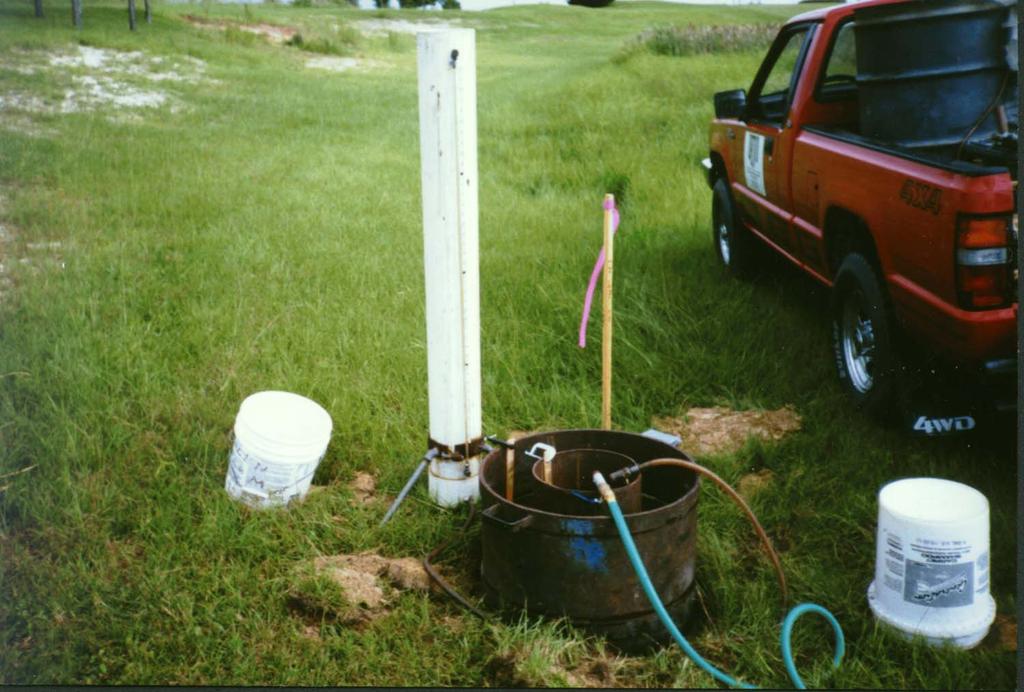
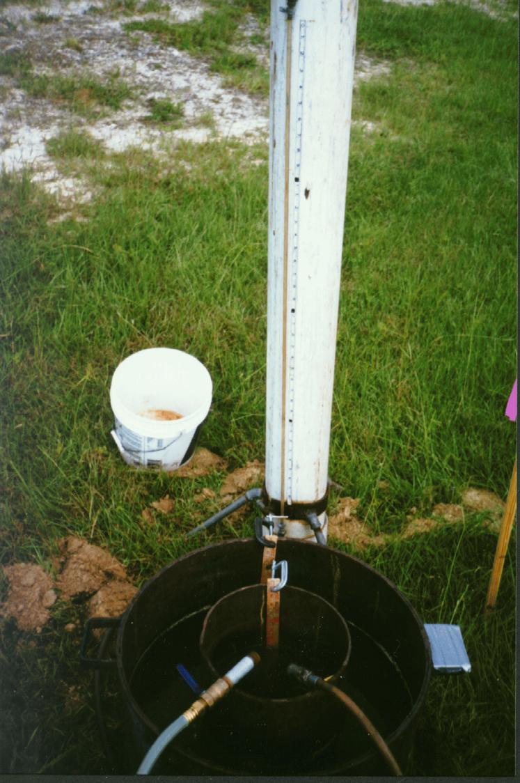
12 RESPONSE TO A FREQUENTLY ASKED QUESTION SJRWMD PONDS WORKSHOP How can the unsaturated vertical infiltration rate be greater than the weighted horizontal saturated hydraulic conductivity? Answer: The unsaturated vertical infiltration rate controls how fast water can enter the soil infiltrative surface and fill the unsaturated zone above the water table. This infiltration rate is usually not affected by more hydraulically restrictive soils below the water table. A minimum factor of safety of 2 is usually applied to this parameter. The weighted horizontal hydraulic conductivity is a weighted average of the assumed thickness of the aquifer which may include clayey sands (with low permeability) in the soil profile. This parameter multiplied by the assumed aquifer thickness controls the lateral transmission of water in the soil. The recommended safety factor for this parameter is unity since it is not subject to clogging as is the unsaturated vertical infiltrative surface.
13
14
PART 1b. Section 7.2 of SJRWMD Special Publication SJ93-SP10
 PART 1b GEOTECHNICAL INVESTIGATION TO ESTIMATE AQUIFER PARAMETERS Note the word is estimate & not determine. Must appreciate the physical meaning of each aquifer parameter. Aquifer, in this sense, does
PART 2D. Section 7.2 of SJRWMD Special Publication SJ93-SP10
 PART 2D GEOTECHNICAL INVESTIGATION TO ESTIMATE AQUIFER PARAMETERS Note the word is estimate & not determine. Must appreciate the physical meaning of each aquifer parameter. Aquifer, in this sense, does
Estimating the Seasonal High Water Table: A Mix of Art & Science
 Estimating the Seasonal High Water Table: A Mix of Art & Science PONDS WORKSHOP - SJRWMD Devo Seereeram, Ph.D., P.E. This paper was originally written over 4 years ago & generated a lot of interest. The
August 15, 2006 (Revised) July 3, 2006 Project No A
 July 3, 2006 Project No A") August 15, 2006 (Revised) July 3, 2006 Project No. 01-05-0854-101A Mr. David Reed, P.E. Protean Design Group 100 East Pine Street, Suite 306 Orlando, Florida 32801 Preliminary Soil Survey Report Polk Parkway
August 15, 2006 (Revised) July 3, 2006 Project No. 01-05-0854-101A Mr. David Reed, P.E. Protean Design Group 100 East Pine Street, Suite 306 Orlando, Florida 32801 Preliminary Soil Survey Report Polk Parkway
Report of Preliminary Geotechnical Engineering Investigation for Ponds
 Report of Preliminary Geotechnical Engineering Investigation for Ponds Segment 2: State Road 400 (SR 400)/Interstate 4 (I-4) from West of SR 528 (Beachline Expressway) to West of SR 435 (Kirkman Road)
Continuous Simulation Modeling of Stormwater Ponds, Lakes, & Wetlands: A BUILT-IN APPLICATION OF PONDS 3.2
 Continuous Simulation Modeling of Stormwater Ponds, Lakes, & Wetlands: A BUILT-IN APPLICATION OF PONDS 3.2 PRESENTED AT THE SFWMD WORKSHOP PRE-DEVELOPMENT VERSUS POST DEVELOPMENT RUNOFF VOLUME ANALYSIS
ORLANDO SANFORD INTERNATIONAL AIRPORT OUTPARCEL 1 SANFORD, FLORIDA
 PRELIMINARY GEOTECHNICAL STUDY ORLANDO SANFORD INTERNATIONAL AIRPORT OUTPARCEL 1 SANFORD, FLORIDA November 9, 2015 Prepared For: Ms. Diane H. Crews, A.A.E. Sanford Airport Authority 1200 Red Cleveland
Report of Preliminary Geotechnical Engineering Investigation for Ponds
 Report of Preliminary Geotechnical Engineering Investigation for Ponds Segment 3: State Road 400 (SR 400)/Interstate 4 (I-4) from One Mile East of SR 434 to East of SR 15-600/US 17-92 Seminole County (77160),
PREDEVELOPMENT VERSUS POSTDEVELOPMENT VOLUME ANALYSIS: An Application of Continuous Simulation Modeling using PONDS Version 3 Software
 PREDEVELOPMENT VERSUS POSTDEVELOPMENT VOLUME ANALYSIS: An Application of Continuous Simulation Modeling using PONDS Version 3 Software PRESENTATION TO: SOUTH FLORIDA WATER MANAGEMENT DISTRICT RFP No. C-8501
Continuous Simulation Example Problem
 Continuous Simulation Example Problem The following examples provided an introduction to the continuous simulation hydrograph in the PONDS 3.2 Refined Method software, with an emphasis on wetland hydroperiod
Applicant s Handbook, Volume II (including Appendices A through F`) is Incorporated by Reference in Rule , F.A.C.
 is Incorporated by Reference in Rule , F.A.C.") REFERENCES AND DESIGN AIDS FOR THE ENVIRONMENTAL RESOURCE PERMIT APPLICANT S HANDBOOK VOLUME II FOR USE WITHIN THE GEOGRAPHIC LIMITS OF THE NORTHWEST FLORIDA WATER MANAGEMENT DISTRICT Applicant s Handbook,
REFERENCES AND DESIGN AIDS FOR THE ENVIRONMENTAL RESOURCE PERMIT APPLICANT S HANDBOOK VOLUME II FOR USE WITHIN THE GEOGRAPHIC LIMITS OF THE NORTHWEST FLORIDA WATER MANAGEMENT DISTRICT Applicant s Handbook,
ORLANDO SANFORD INTERNATIONAL AIRPORT OUTPARCEL 6 SANFORD, FLORIDA
 PRELIMINARY GEOTECHNICAL STUDY ORLANDO SANFORD INTERNATIONAL AIRPORT OUTPARCEL 6 SANFORD, FLORIDA November 9, 2015 Prepared For: Ms. Diane H. Crews, A.A.E. Sanford Airport Authority 1200 Red Cleveland
REFERENCES AND DESIGN AIDS FOR ENVIRONMENTAL RESOURCE PERMIT APPLICANT S HANDBOOK VOLUME II
 REFERENCES AND DESIGN AIDS FOR ENVIRONMENTAL RESOURCE PERMIT APPLICANT S HANDBOOK VOLUME II FOR USE WITHIN THE GEOGRAPHIC LIMITS OF THE NORTHWEST FLORIDA WATER MANAGEMENT DISTRICT Applicant s Handbook,
Stormwater Retention Pond Recovery Analysis
 Stormwater Retention Pond Recovery Analysis By Nicolas E Andreyev The first in a series of courses on Green Drainage Design www.suncam.com Page 1 of 33 Forward To design a stormwater retention pond, one
Determination of Design Infiltration Rates for the Sizing of Infiltration based Green Infrastructure Facilities
 Determination of Design Infiltration Rates for the Sizing of Infiltration based Green Infrastructure Facilities 1 Introduction This document, developed by the San Francisco Public Utilities Commission
A-2. Soils. Soil Media. Chapter Contents. Soil Media In-situ Soil Testing Separation from Seasonal High Water Table (SHWT)
") A-2. Soils Chapter Contents Soil Media In-situ Soil Testing Separation from Seasonal High Water Table (SHWT) Importance of Soil Composition in SCMs The soil composition of many stormwater SCMs also is
A-2. Soils Chapter Contents Soil Media In-situ Soil Testing Separation from Seasonal High Water Table (SHWT) Importance of Soil Composition in SCMs The soil composition of many stormwater SCMs also is
Ponds: planning, design, and construction
 Ponds: planning, design, and construction Ponds for many purposes: Fish Production Recreation Water Supply Esthetics Wildlife Habitat Natural ponds: Formed in natural depressions in the landscape Not man-made
SUMMARY REPORT OF A GEOTECHNICAL SITE EXPLORATION LACROSSE CITRUS REPOSITORY LACROSSE, ALACHUA COUNTY, FLORIDA. GSE PROJECT No.
 SUMMARY REPORT OF A GEOTECHNICAL SITE EXPLORATION LACROSSE CITRUS REPOSITORY LACROSSE, ALACHUA COUNTY, FLORIDA GSE PROJECT No. 1128 Prepared For: BURE OF CITRUS BUDWOOD REGISTRATION SEPTEMBER 2011 Certificate
Infiltration Testing For Stormwater BMPs: What Would Mickey Mouse Do?
 Infiltration Testing For Stormwater BMPs: What Would Mickey Mouse Do? CCLC Turning A New Leaf November 3, 2017 David J. Hirschman Hirschman Water & Environment, LLC www.hirschmanwater.com dave@hirschmanwater.com
Preliminary Soil Survey Report
 Florida Department of TRANSPORTATION Preliminary Soil Survey Report Malabar Road (SR 514) PD&E Study From East of Babcock Street (SR 507) to US 1 Brevard County, Florida FPID: 430136 1 22 01 ETDM: 13026
Water Resources Management Plan
 B u r n s v i l l e M i n n e s o t a Water Resources Management Plan - Volume Control / Infiltration Worksheet This Appendix contains a worksheet and related information that can be used for evaluating
How & Where does infiltration work? Context: Summary of Geologic History Constraints/benefits for different geologic units
 Associated Earth Sciences, Inc. Associated Earth Sciences, Inc. Presented by: Matthew A. Miller, PE April 23, 2013 How & Where does infiltration work? Context: Summary of Geologic History Constraints/benefits
This report presents the findings of the subsurface exploration concerning the design of the taxiway rehabilitation. Description
 September 22, 2016 American Infrastructure Development, Inc. 3810 Northdale Boulevard, Suite 170 Tampa, Florida 33624 Attn: Mr. Mohsen Mohammadi, Ph.D., P.E. Senior Consultant Mob: (813) 244-6609 E-mail:
100% Report of Geotechnical Engineering Investigation CENTRAL FLORIDA COMMUTER RAIL TRANSIT SUNRAIL PHASE 2 SOUTH Poinciana Vehicle Storage & Light
 100% Report of Geotechnical Engineering Investigation CENTRAL FLORIDA COMMUTER RAIL TRANSIT SUNRAIL PHASE 2 SOUTH Poinciana Vehicle Storage & Light Maintenance Facility (VSLMF) Osceola County, Florida
AESI AESI 6/17/2015 HOW AND WHERE DOES INFILTRATION WORK? o Context: Summary of Geologic History. o Constraints/benefits for different geologic units
 PRESENTED June 17, 2014 BY Jim Brisbine, PE HOW AND WHERE DOES INFILTRATION WORK? o Context: Summary of Geologic History o Constraints/benefits for different geologic units o Key geologic and groundwater
SECTION 1 BIO-INFILTRATION BUMP OUTS (BIBO)
") SECTION 1 BIO-INFILTRATION BUMP OUTS (BIBO) This guide specification for U.S. applications describes construction of bio-infiltration bump outs (or bioretention ) systems. From the surface down to the
SECTION 1 BIO-INFILTRATION BUMP OUTS (BIBO) This guide specification for U.S. applications describes construction of bio-infiltration bump outs (or bioretention ) systems. From the surface down to the
TABLE OF CONTENTS. 5.0 LABORATORY TESTING Corrosion Series Testing Consolidation Testing... 5
 TABLE OF CONTENTS 1.0 SITE AND PROJECT DESCRIPTION... 1 2.0 NRCS SOIL SURVEY... 1 3.0 USGS POTENTIOMETRIC MAP DATA... 2 4.0 SUBSURFACE EXPLORATION... 3 4.1 SPT Borings... 3 4.2 Groundwater Measurement...
Background Information on the. Peace River Basin
 Background Information on the Peace River Basin Resource Conservation & Development Department August 24 Background Physiography The Peace River drainage basin occupies large parts of Polk, Hardee, DeSoto,
APPENDIX D EXTINCTION-DEPTH DETERMINATION
 APPENDIX D EXTINCTION-DEPTH DETERMINATION by Robert Freese SJRWMD 1 Page Intentionally Blank 2 EXTINCTION-DEPTH DETERMINATION Shah et al. (2007) define extinction depth as the depth to water table at which
What is the Vadose Zone? Why Do We Care? Tiffany Messer Assistant Professor Biological Systems Engineering School of Natural Resources University of
 What is the Vadose Zone? Why Do We Care? Tiffany Messer Assistant Professor Biological Systems Engineering School of Natural Resources University of Nebraska-Lincoln Learning Objectives History of Vadose
Module 3: Rainfall and Hydrology for Construction Site Erosion Control
 Module 3: Rainfall and Hydrology for Construction Site Erosion Control Robert Pitt Department of Civil, Construction, and Environmental Engineering University of Alabama Tuscaloosa, AL Rainfall and Hydrology
Jacobi, Toombs, and Lanz, Inc.
 Area 5: Blackiston Mill Road at Dead Man's Hollow Flooding Assessment Jacobi, Toombs, and Lanz, Inc. This document summarizes an assessment of drainage and flooding concerns and provides recommendations
Appendix I. Potential Adverse Change to Wetland Function Methodology and Results
 Appendix I Potential Adverse Change to Wetland Function Methodology and Results Technical Memorandum North Florida Regional Water Supply Plan Potential Adverse Change to Wetland Function January 3, 2017
APPENDIX C Site Evaluation Checklists
 APPENDIX C Site Evaluation Checklists C-1 GENERAL Water Management analysis and design for airfields are based on a variety of site data for both the existing condition and the proposed project(s). The
HYDRIC SOILS. By Neal Svendsen Resource Soil Scientist Natural Resources Conservation Service Sept 2006
 HYDRIC SOILS By Neal Svendsen Resource Soil Scientist Natural Resources Conservation Service Sept 2006 Wetlands and Hydric Soils The term hydric soils proposed by Cowardin in 1979 Classification of Wetlands
WEST VILLAGES IMPROVEMENT DISTRICT PLAN OF IMPROVEMENTS FOR UNIT 3 REFINANCING
 WEST VILLAGES IMPROVEMENT DISTRICT PLAN OF IMPROVEMENTS FOR UNIT 3 REFINANCING Prepared for: West Villages Improvement District c/o Special District Services, Inc. 2501A Burns Road Palm Beach Gardens,
For. Report of Geotechnical Exploration. St. Johns Parkway Race Track Road to Espada Lane 8-inch Reclaimed Water Main St.
 Report of Geotechnical Exploration For St. Johns Parkway Race Track Road to Espada Lane 8-inch Reclaimed Water Main St. Johns County, FL MAE Project No. 0106-0005 June 14, 2017 Prepared for: CPH, Inc.
Appendix 10-A. Optional Recharge Volume Approach
 Appendix 10-A Optional Recharge Volume Approach Table of Contents APPENDIX SECTION HEADINGS 10-A.0 INTRODUCTION 10-A-2 10-A.1 Horsely Method for Determining Recharge Volumes 10-A-2 10-A.1.1 Basis for Determining
PONDS 3.2 TECHNICAL MEMO
 PONDS 3.2 TECHNICAL MEMO Date: December 7, 2007 Re: Using PONDS for Dewatering Analysis The following technical memo outlines the use of the PONDS 3.2 Refined Method software to perform a dewatering analysis
CITY OF MONTCLAIR Montclair Civic Center 5111 Benito Street Montclair, CA 91763
 CITY OF MONTCLAIR Montclair Civic Center 5111 Benito Street Montclair, CA 91763 I. Introduction Water Quality A National, State, and Local Concern Throughout the United States, many rivers, creeks, streams,
November 2007 DRAFT Appendix E: Soil Testing Criteria
 November 2007 DRAFT Appendix E: Soil Testing Criteria Stormwater management design is dependent upon the changes that occur between pre and postdevelopment conditions. The impacts are assessed based on
1. Introduction Site Information Site Characteristics Hydrogeologic Setting... 2
 Table of Contents 1. Introduction... 1 1.1 Site Information... 1 1.2 Site Characteristics... 1 1.3 Hydrogeologic Setting... 2 2. Closure Plan... 5 2.1 Closure Description... 5 2.2 Closure Timeframe...
( ) or 811 or mo1call.com
 or 811 or mo1call.com") Missouri One Call 1-800-DIG RITE (800-344-7483) or 811 or mo1call.com Missouri One Call 1-800-DIG RITE (800-344-7483) or 811 or mo1call.com Missouri One Call 1-800-DIG RITE (800-344-7483) or 811 or mo1call.com
Missouri One Call 1-800-DIG RITE (800-344-7483) or 811 or mo1call.com Missouri One Call 1-800-DIG RITE (800-344-7483) or 811 or mo1call.com Missouri One Call 1-800-DIG RITE (800-344-7483) or 811 or mo1call.com
Deep River-Portage Burns Waterway Watershed 2015
 2.4 Soils Soil development is the product of the interaction of parent material, topography, climate, organisms and time. Understanding the types of soils that exist within a watershed and their characteristics
March 28, Port of Kalama Mr. Jacobo Salan 380 West Marine Drive Kalama, Washington 98625
 11917 NE 95 th Street, Vancouver, Washington 98682 Phone: 360-823-2900, Fax: 360-823-2901 March 28, 2014 Port of Kalama Mr. Jacobo Salan 380 West Marine Drive Kalama, Washington 98625 Re: Construction
STORMWATER MANAGEMENT. 158 Attachment 2. Borough of Perkasie
 158 Attachment 2 Borough of Perkasie Appendix B Site Soil Evaluation and Soil Infiltration Testing Source: Pennsylvania Stormwater Best Management Practice Manual, December 2006. SITE SOIL EVALUATION AND
Report of Geotechnical Engineering Investigation OIA SOUTH CELL LOT (W340) AID Project No. GOA16001 Orange County, Florida GEC Project No.
 AID Project No. GOA16001 Orange County, Florida GEC Project No.") Report of Geotechnical Engineering Investigation OIA SOUTH CELL LOT (W40) AID Project No. GOA16001 Orange County, Florida GEC Project No. 956G July 6, 2017 American Infrastructure Development, Inc. 7 North
Report of Geotechnical Engineering Investigation OIA SOUTH CELL LOT (W40) AID Project No. GOA16001 Orange County, Florida GEC Project No. 956G July 6, 2017 American Infrastructure Development, Inc. 7 North
Stormwater Treatment Practice (STP) Calculator Instructions
 Calculator Instructions") Stormwater Treatment Practice (STP) Calculator Instructions The STP Calculator is a tool developed by the Department of Environmental Conservation (DEC) to estimate total phosphorus load reductions achieved
Stormwater Treatment Practice (STP) Calculator Instructions The STP Calculator is a tool developed by the Department of Environmental Conservation (DEC) to estimate total phosphorus load reductions achieved
Names: ESS 315. Lab #6, Floods and Runoff Part I Flood frequency
 Names: ESS 315 Lab #6, Floods and Runoff Part I Flood frequency A flood is any relatively high flow of water over land that is not normally under water. Floods occur at streams and rivers but can also
November 13, IP3406. Mr. Uriah Sowell Rooney Engineering 115 Inverness Drive East, Suite 300, Englewood, CO 80112
 November 13, 2015 103IP3406 Mr. Uriah Sowell Rooney Engineering 115 Inverness Drive East, Suite 300, Englewood, CO 80112 Subject: Infiltration Testing Gates Road Valve Site Sunoco Pennsylvania Pipeline
City of Vineland Health Department 640 E. Wood Street, Vineland, NJ (856) (ph.) / (856) (fax)
 (ph.) / (856) (fax)") Permit No. Form 1 General Information Type of Permit Needed (Check Applicable Category): New Construction New (Existing Structure) Repair *Malfunctioning (In-Kind Replacement) Repair No Malfunction (In-Kind
Permit No. Form 1 General Information Type of Permit Needed (Check Applicable Category): New Construction New (Existing Structure) Repair *Malfunctioning (In-Kind Replacement) Repair No Malfunction (In-Kind
Typical Subsurface Profile. November 28, 2016
 November 28, 2016 RSCCD Facility Planning, District Construction and Support Services 2323 N. Broadway, Suite 112, Santa Ana, CA 92706 Attn: Re: Ms. Allison Coburn Facilities Project Manager P: (714) 480-7530
0 Issued for Information JAJ/ JCP/ JCP/
 Project/Plant: Plant McManus Title/Subject: Factor of Safety Assessment for CCR Rule Purpose/Objective: Analyze Factor of Safety of the Ash Pond Dike System or Equipment Tag Numbers: NA Contents Engineering
WQ-08 ENHANCED DRY SWALE
 Greenville County Technical Specification for: WQ-08 ENHANCED DRY SWALE 1.0 Enhanced Dry Swale 1.1 Description An Enhanced Dry Swale is a shallow open-channel drainage way stabilized with turf grass or
Infiltration Guidelines
 Appendix E Infiltration Guidelines As a stormwater management method, infiltration means retaining or detaining water within soils to reduce runoff. Infiltration can be a cost-effective method to manage
REPORT OF GEOTECHNICAL EXPLORATION WEST MARJORY AVENUE TAMPA, FLORIDA
 REPORT OF GEOTECHNICAL EXPLORATION WEST MARJORY AVENUE TAMPA, FLORIDA AREHNA PROJECT NO. B-15-008 March 11, 2015 Prepared For: City of Tampa Stormwater Division 306 W. Jackson Street, 6N Tampa, Florida
Computation of excess stormflow at the basin scale. Prof. Pierluigi Claps. Dept. DIATI, Politecnico di Torino
 Computation of excess stormflow at the basin scale Prof. Pierluigi Claps Dept. DIATI, Politecnico di Torino Pierluigi.claps@polito.it losses include: interception, evapotranspiration, storage infiltration,
Stormwater Management Studies in Areas Undergoing Reconstruction Following the Tornado that Hit Tuscaloosa, AL
 Stormwater Management Studies in Areas Undergoing Reconstruction Following the Tornado that Hit Tuscaloosa, AL Redahegn Sileshi, Robert Pitt 2, Shirley Clark 3, and Chad Christian 4 PhD Candidate, The
In preparation for constructing buildings on a property, the builder. Site Preparation CHAPTER
 CHAPTER 3 Site Preparation In preparation for constructing buildings on a property, the builder must consider a number of factors related to code requirements. The buildings must be located according to
Appendix C Geotechnical Soil Testing Data
 Appendix C Geotechnical Soil Testing Data rjmmmrorr Table C-1 Laboratory Soil Testing Results Groundwater Assessment Report UMore Mining Area Dakota County, Minnesota Sample Particle Size Particle Size
This Page Intentionally Left Blank
 GEOTECHNICAL REPORT This Page Intentionally Left Blank July 30, 2014-Revised December 11, 2013 South Florida Water Management District 3301 Gun Club Road West Palm Beach, Florida 33406 Attn: Mr. Jesse
Re: Geotechnical Consultation for Storm Infiltration Robert Louis Stevenson ES Modernization th Avenue San Francisco, California
 Date: August 4, 2015 Project No.: 608-4-2 Prepared For: Mr. Sajeev Madhaven, AIA SAN FRANCISCO UNIFIED SCHOOL DISTRICT 135 Van Ness Avenue - Room 207a San Francisco, California 94102 Re: Geotechnical Consultation
Preliminary Geotechnical Engineering Report
 Preliminary Geotechnical Engineering Report Phases I and II BV-4B Dredged Material Management Area (DMMA) Brevard County, Florida December 8, 2014 Terracon Project No. HB145006 Prepared for: Taylor Engineering,
Soil Class Handouts Greeley Colorado October 22 & 23, 2015
 Soil Class Handouts Greeley Colorado October 22 & 23, 2015 1. Hand Texturing Flow Chart 2. Table 10-1 Soil Treatment Area Long Term Acceptance Rates by Soil Texture, Soil Structure, Percolation Rate and
Treatment Volume: Curve Numbers. Composite CN or Not? Treatment Volume: Curve Numbers. Treatment Volume: Calculation. Treatment Volume: Calculation
 Stormwater Engineering Bioretention Design Bill Hunt, PE, Ph.D. Extension Specialist & Assistant Professor NCSU-BAE www.bae.ncsu.edu/stormwater Bioretention Design Six Step Process 1 Determine Volume to
 Appendix A - Vicinity Map Vicinity Map: Palm Beach Gardens City Hall Additions, 000 N Military Trail, Palm Beach Gardens, FL Proposed Location of Police Dept. Attached Addition Proposed Location of New
Permeable Pavement: A New Chapter
 Permeable Pavement: A New Chapter Annette Lucas, PE (919) 807-6381 annette.lucas@ncdenr.gov NC Division of Water Quality Wetlands & Stormwater Branch Final Chapter Released: October 16, 2012 We Bring Engineering
9. SOIL PERMEABILITY. 9.0 Why is it important to determine soil permeability?
 9. SOIL PERMEABILITY 9.0 Why is it important to determine soil permeability? Soil permeability is the property of the soil to transmit water and air and is one of the most important qualities to consider
Memorandum. MIDS Work Group Barr Engineering Company
 Memorandum To: From: MIDS Work Group Barr Engineering Company Subject: Turf, Phase 2, MIDS Task 2.2: Recommend Credits for MIDS Practices Date: May 31, 2013 Project: 23/62 1050 MIDS Barr was asked to evaluate
Addendum # 1 Public Safety Complex Wetland Date of Addendum: 2/23/17
 Wicomico County Purchasing 125 N. Division St. Room B-3 Salisbury, MD 21801 Ph. 410-548-4805 Fax 410-334-3130 Email: purchasing@wicomicocounty.org Addendum # 1 Public Safety Complex Wetland Date of Addendum:
Groundwater and Base Flow BMPs BMPs for Nitrogen Removal in Marion County
 Groundwater and Base Flow BMPs BMPs for Nitrogen Removal in Marion County September 9, 2016 Evan Shane Williams, Ph.D., P.E. Marion County Office of the County Engineer Marion County is home to three First
Section 1I-3 - Bioswales
 BIOSWALES (Numbering pending) These specifications compliment the bioswale design portion of the Iowa Stormwater Management Manual in Chapter 2, Section 2I-3. Sections of the following documents, as referenced
Mapping and Understanding YOUR LAKE S WATERSHED By: Tony Groves, Pam Tyning, and Tory Meyers Water Resources Group, Progressive AE
 By: Tony roves, Pam Tyning, and Tory Meyers Water Resources roup, Progressive A What is a Watershed? A watershed is the land area surrounding a lake from which water drains to the lake. The imaginary line
CHAPTER 4 GEOTECHNICAL SITE CHARACTERIZATION
 CHAPTER 4 GEOTECHNICAL SITE CHARACTERIZATION Chapter Organization 4.1 Introduction... 4-1 4.2 Applicability... 4-1 4.3 Minimimum Requirements... 4-2 4.3.1 Geotechnical Site Characterization Report... 4-3
Concurrent Session B: LID Design Specifications (Chapter 4 in Draft Manual)
") Concurrent Session B: LID Design Specifications (Chapter 4 in Draft Manual) Should vs. Must In Chapter 4, should means should, and must means must. Poorly Drained Soils Well-Drained Soils Flat Terrain
Concurrent Session B: LID Design Specifications (Chapter 4 in Draft Manual) Should vs. Must In Chapter 4, should means should, and must means must. Poorly Drained Soils Well-Drained Soils Flat Terrain
HSA ENGINEERS & SCIENTISTS. A member of the CRA family of companies
 HSA ENGINEERS & SCIENTISTS A member of the CRA family of companies Report of Pavement Coring and Services Town of Belleair Rosery Road Seawall, Roadway and Drainage Improvements Atkins 4030 West Boy Scout
Soil, Landscape, Hydrology Relationships
 Soil, Landscape, Hydrology Relationships Soil Hydrologic Cycle Unsaturated Soils with Suction (Tension) Forces Water under a suction, pulls particles together. This water is not free water, it is not free
Continuing Education Course #209 Green Irrigation Fundamentals Balancing Aquifer Recharge and Withdrawal
 1 of 7 Continuing Education Course #209 Green Irrigation Fundamentals Balancing Aquifer Recharge and Withdrawal 1. The balanced irrigation water demand is based mainly on (hint: water created by the improvements):
Rational Method for In-Situ Prediction of the Vertical Saturated Hydraulic Conductivity of Soils
 Rational Method for In-Situ Prediction of the Vertical Saturated Hydraulic Conductivity of Soils 1 BY: M ILAD FATEHNIA P H D C A N D I D A T E O F C I V I L E N G I N E E R I N G C I V I L A N D E N V
POND SEALING OR LINING COMPACTED SOIL TREATMENT
 NATURAL RESOURCES CONSERVATION SERVICE CONSERVATION PRACTICE STANDARD POND SEALING OR LINING COMPACTED SOIL TREATMENT CODE 520 (FT. 2 ) DEFINITION A liner for an impoundment constructed using compacted
APPENDIX A DRAINAGE STUDY PHASE 2 ALTERNATIVE IMPROVEMENTS CRYSTAL LAKE ALTERNATIVE 4C IMPROVEMENTS LAKEWOOD PIRATELAND SWASH HORRY COUNTY, SC
 DRAINAGE STUDY PHASE ALTERNATIVE IMPROVEMENTS CRYSTAL LAKE ALTERNATIVE C IMPROVEMENTS ` FOR: LAKEWOOD PIRATELAND SWASH HORRY COUNTY, SC APPENDIX A J-.000 Prepared by: Savannah, GA Charleston, SC Myrtle
Septic Tank Soil Treatment Systems
 Bulletin 939 Septic Tank Soil Treatment Systems for Ohio Rural Homes Copyright 2009, The Ohio State University Ohio State University Extension embraces human diversity and is committed to ensuring that
LAKE LABELLE ENGINEERING REPORT
 154 N. Bridge Street, LaBelle, Florida 33935 -Tel: (863) 612-0011 Fax: (863) 612-0014 - email: rock@rockhendry.com LAKE LABELLE ENGINEERING REPORT PREPARED FOR Lake LaBelle, LLC March 2014 PREPARED BY:
University of Florida Conservation Areas Land Management Plan Trillium Slope (Golf Course Woods)
") University of Florida Conservation Areas Land Management Plan Trillium Slope (Golf Course Woods) Introduction Trillium Slope (Golf Course Woods) is a 4.9-acre Conservation Area named after a plant that
University of Florida Conservation Areas Land Management Plan Trillium Slope (Golf Course Woods) Introduction Trillium Slope (Golf Course Woods) is a 4.9-acre Conservation Area named after a plant that
TURNPIKE SUPPLEMENT FDOT DRAINAGE MANUAL
 TURNPIKE SUPPLEMENT TO THE FDOT DRAINAGE MANUAL FLORIDA S TURNPIKE ENTERPRISE DRAINAGE DESIGN OFFICE January 2018 INTRODUCTION As part of the Turnpike s continuing quality enhancement effort, this Supplement
REPORT OF GEOTECHNICAL EXPLORATION AND ENGINEERING ANALYSIS
 FIGURE 3 Geotechnical Report (2) REPORT OF GEOTECHNICAL EXPLORATION AND ENGINEERING ANALYSIS RIVER TOWER RESTORATION RIVER TOWER PARK TAMPA, FLORIDA AREHNA PROJECT NO. B-13-002 February 22, 2013 Prepared
An Explanation of the Hydric Soil Technical Standard and Normal Precipitation
 An Explanation of the Hydric Soil Technical Standard and Normal Precipitation From: National Technical Committee for Hydric Soils. 2001. Hydric Soil Technical Standard (Technical Note 11). http://soils.usda.gov/soil_us
TRIP REPORT ARCONA ROAD VALVE SITE INFILTRATION TESTING
 TRIP REPORT ARCONA ROAD VALVE SITE INFILTRATION TESTING 1.0 PURPOSE This Trip Report presents the field data and results of double-ring soil infiltration tests conducted to support the design of a stormwater
BURLINGTON COUNTY HEALTH DEPARTMENT 15 PIONEER BOULEVARD, WESTAMPTON PO BOX 6000 MOUNT HOLLY, NEW JERSEY 08060
 BURLINGTON COUNTY HEALTH DEPARTMENT 15 PIONEER BOULEVARD, WESTAMPTON PO BOX 6000 MOUNT HOLLY, NEW JERSEY 08060 APPLICATION FOR APPROVAL TO CONSTRUCT/ALTER AN INDIVIDUAL SUBSURFACE SEWAGE DISPOSAL SYSTEM
INFRASTRUCTURE ELEMENT/NATURAL GROUNDWATER AQUIFER RECHARGE SUB-ELEMENT
 I. INTRODUCTION A. Purpose As provided in this Natural Groundwater Aquifer Recharge Sub-element, the City of Ocoee has developed guidelines based on the St. Johns River Water Management District s programs.
Bioreactor Landfill Design
 Bioreactor Landfill Design Timothy Townsend, PhD, PE Department of Environmental Engineering Sciences University of Florida ttown@ufl.edu Bioreactor Landfill Design Modern landfill design entails many
On-site Systems and Groundwater Washington State Department of Health February 6, 2014
 On-site Systems and Groundwater Washington State Department of Health February 6, 2014 1 Nancy Darling, LHG, CPSS Office of Shellfish and Water Protection Key Groundwater Considerations Type and strength
A. Exemptions from the Geotechnical/Geological Engineering Report submittal requirements are:
 CHAPTER 800. SECTION 807. NATURAL AND CULTURAL RESOURCES PROTECTION SOILS AND GEOTECHNICAL HAZARDS 807.1. Intent and Purpose The intent and purpose of this section is to evaluate the suitability of soils
Stormwater Review Part 2. Rainfall and Runoff. Tom Seybert, PE and Andy Bennett, PE. Pennsylvania Surveyors Conference 2019
 Stormwater Review Part 2 Rainfall and Runoff Tom Seybert, PE and Andy Bennett, PE Pennsylvania Surveyors Conference 2019 1 Topics Covered 1. Rainfall characteristics and sources 2. Watershed characteristics
PONDS 3.2 Technical Memo SUBJECT:
 PONDS 3.2 Technical Memo SUBJECT: MODELING MULTIBASIN / INTERCONNECTED PONDS Date: January 21, 2008 The following memo discusses the Multibasin SCS hydrograph in the PONDS 3.2 Refined Method software,
ENGINEERING HYDROLOGY
 ENGINEERING HYDROLOGY Prof. Rajesh Bhagat Asst. Professor Civil Engineering Department Yeshwantrao Chavan College Of Engineering Nagpur B. E. (Civil Engg.) M. Tech. (Enviro. Engg.) GCOE, Amravati VNIT,
4. GEOTECHNICAL FIELD INVESTIGATION SUMMARY
 Rev. 0 Date: AUGUST 18, 2012 Project.: COUVA CHILDREN S HOSPITAL - COUVA, TRINIDAD Page 29 Title: EISL-412-DD-TR-2012 PRELIMINARY GEOTECHNICAL FEASIBILITY REPORT 4. GEOTECHNICAL FIELD INVESTIGATION SUMMARY
Report of Geotechnical Exploration For Baymeadows Road/Old Still PUD 6 inch Reclaimed Water Main Jacksonville, FL
 Report of Geotechnical Exploration For Baymeadows Road/Old Still PUD inch Reclaimed Water Main Jacksonville, FL MAE Project No. 0 000 June, 0 Prepared for: CPH, Inc. 00 Belfort Road, Suite 0 Jacksonville,
CCR Rule Operating Criteria Closure Plan
 CCR Rule Operating Criteria 257.102 Closure Plan FGD Pond 2 Jim Bridger Plant Point of Rocks, Wyoming PREPARED FOR PacifiCorp 1407 West North Temple Salt Lake City, UT 84116 (801) 521-0376 Fax (801) 220-4748
GREEN CITY, CLEAN WATERS
 GREEN CITY, CLEAN WATERS Investigation of Infiltration in Unsaturated Urban Fill Material VUSP Pennsylvania Stormwater Symposium October 15, 2015 Dan O Rourke, CDM Smith Jason Cruz, Philadelphia Water