Sedimentation and Remote Sensing
|
|
|
- Jeffrey Marsh
- 5 years ago
- Views:
Transcription


1 Sedimentation and Remote Sensing Introduction: A certain amount of released earth materials into water or the atmosphere is a natural occurrence; however, excessive sedimentation is of concern when environmental or commercial problems arise from the process. It is also of concern when the sedimentation is clearly the result of erosion, possibly due to urbanization, poor farming practices and industries such as mining. The tie to physical science is in the physics of soil processes such as infiltration, runoff and permeability. Infiltration is the rate of entry of precipitation into the surface of soil, runoff is the percentage of precipitation which does not enter the soil and permeability is the ease with which water can travel through the soil profile, usually measured as a rate as well. Infiltration rate is dependent upon several factors which are difficult to quantify, including soil type (textural), soil structure and slope. There is a dual nature to soil on a gradient and all of it is indeed on a slippery slope. If infiltration is not sufficient, runoff occurs and pulls soil particles with it in a steady stream. However, if infiltration is too great, massive earth movement called mudslides can occur. U.S.G.S Public U.S.G.S. Public Affairs Office, Menlo Park, CA. Affairs Office Menlo Park, California Infiltration rate is lowest for clay particles in a massive structure on a steep slope. Clay profiles are characterized by a larger volume of pore space than sand, but all pores are much smaller than those for sand. Movement through the soil is not due to a gravitational gradient (as in sand) but is due to electrostatic attraction between hydrogen in water and electronegative elements in the soil (oxygen, silicon, etc.) The overall process is slow and there is usually not sufficient time for absorption due to rapid water flow on a steep grade unless there is sufficient vegetation to trap water for a longer time period. Clay or sand are soil textures; soil structure consists of a secondary organization of soil particles into shapes such as granular, cubic, columnar or one large mass (massive). The advantage of cubic or columnar shapes for infiltration is that channels exist in the soil which are larger than the individual pores and allow more rapid infiltration.
/ µ where q is fluid flux, k is permeability, Pb is pressure at base of")

2 blocky structure of subsoil There are various equations for fluid flux through a permeable material; Darcy s law is probably best known: q = -k (Pb Pa)/ µ where q is fluid flux, k is permeability, Pb is pressure at base of fluid front, Pa is pressure at fluid head and µ is viscosity of the fluid. Flux is measured as m3/m2/s, which reduces to m/s. There are other equations which consider additional criteria, but all are dependent on permeability. One equation for hydraulic conductivity, which is similar to Darcy s is: K = k γ/ µ where K is hydraulic conductivity, k is permeability, γ is specific weight of water, and µ is viscosity of water. For standard conditions, hydraulic conductivity is very close to permeability. Hydraulic conductivity technically can vary with conditions of flow while permeability is a property of the soil itself. Permeability can be calculated with an equation: k = C d2 where k is permeability, C is a configuration constant and d is average pore diameter. Configuration constants can be estimated from texture and structure, but usually permeability is best measured empirically. Table 1. Size limits (diameter in millimeters) of soil separates in the USDA soil textural classification system.
3 Name of soil separate Diameter limits (mm) Very coarse sand* Coarse sand Medium sand Fine sand Very fine sand Silt Clay less than * Note that the sand separate is split into five sizes (very coarse sand, coarse sand, etc.). The size range for sands, considered broadly, comprises the entire range from very coarse sand to very fine sand, i.e., mm. edis.ifas.ufl.edu/ss169 We are going to equate infiltration with permeability although they are technically different. Infiltration is dependent on permeability but also soil surface conditions. Permeability is typically measured under saturated flow conditions, which we will emulate in the laboratory, but infiltration rate can vary widely due to incoming rate of water. In the following laboratory, we will measure permeability for two soils- a clay and a sand- and look at permeability for these soils on a slope. Laboratory procedure: 1. Set up a canister with holes on the bottom, lined with filter paper (thin) and fill with sand about the one-fourth of the canister height. 2. Position the canister on a ringstand or other upright apparatus and clamp a hose or buret above the canister. A ring with a wire gauze between the hose and soil will help disperse the water over the soil. 3. Place another empty canister (without holes) below the soil canister (diagram A). 4. Slowly saturate the soil, then one student must adjust the faucet or buret flow until the rate produces ponding water and then back off to a flow where no ponding occurs. 5. Measure the leached water height in cm after about ten minutes and then divide this value by 10 to get permeability flow rate in cm/min.
4 6. For soil on a slope: Remember the faucet speed used in setup A and use this in setup B. The only difference here is that the soil canister will be put on a slope of about 10 degrees. 7. Repeat the same procedure as for setup A (at the same flow rate) and collect leached water in the lower canister for 10 minutes. Calculate permeability in cm/min. 8. Note rate of runoff as well. After 10 minutes, collect the water accumulated on the downward side of the surface with a pipet and place this into a canister of the same size as the others and note height in cm. Divide this by 10 to get runoff rate in cm/min. (If there is no runoff, increase the steepness of the soil until there is runoff and run the experiment again with measurements. Note the angle of inclination in your notebook.) 9. Repeat the entire process for a clay soil. If there is time, repeat the process for clay with plants planted in the soil.


5 A slightly loose hose dispersed water well. A buret was somewhat more precise in pinpointing necessary flow rate. Using a protractor to measure slope Questions: 1. List permeability for the following: Sand, flat: 0.1 cm/min Pipetting runoff from soil at 10-degree incline
6 Sand, tilted: 0.06 cm/min Clay, flat: 0.02 cm/min Clay, tilted: cm/min Clay, tilted, with vegetation: 2. The rate of flow for the flat soils actually represents infiltration rate which is just below the ponding rate. Any type of ponding is considered to be potential runoff and erosive even when on a flat surface, due to imperfections in terrain. Which soil tolerated a higher rate of precipitation without ponding? sand 3. For the same angle, which type of soil produced more runoff, sand or clay? clay 4. What was the nature of the runoff water? (Did it contain soil, etc.) Contained small particles of soil 5. See if the following relationship tentatively worked out in class is a good predictor of runoff rate in cm/min: sinθ x (permeability rate on 0-degree slope) Where: Θ is the angle of slope for the canister Permeability is the rate at 0-degree slope in cm/min For sand at no slope, permeability was 0.1 cm/min Calculated runoff for sand at 10-degree slope: Sin(10) x 0.1 = cm/min Actual runoff rate for sand at 10-degree slope: cm/min 6. a. Determine the gravitational acceleration on a discrete particle of water at the top of a slope which is 14.7 m long at an inclination of 20 degrees. a. Determine the velocity of this particle of water at the bottom of the incline. b. How much time will it take the water to reach the bottom of the slope?
7 7. a. For a sphere of water of cm 3, calculate its mass and gravitational force it possesses on this slope g; F = x 3.35 = N a. The sphere of water will only be able to move a soil sphere of equal size or smaller (due to contact). Assume a coefficient of friction for the soil sphere of 0.9 and a density of 2.65 g/cm 3. What is the radius of the largest sphere the water will move? What classification is it? (sand, silt, clay). Assume the gravitational force Fp of the water on this slope is translated into the lesser horizontal force Fh = Fp (cos 20) once it reaches the bottom: Fp = N Fh = N Assume Fh is equal to frictional force Ff to produce movement of constant velocity (not acceleration). This corresponds to the largest soil particle which can be moved. Ff= µfn = 0.9Fn where Fn is the weight of the soil particle Fn = N The mass of the particle = N/9.8 = g 2.65 g/cm 3 = g/x x = cm 3 Vol of sphere = = 4/3 πr 3 r = 5.1 x 10⁻² cm; Medium sand Relating sedimentation to remote sensing: Sedimentation can benefit agriculture by depositing nutrients on flood plains and extending delta land, but also costs humans in terms of flood damage, waterway

8 clogging, poor water quality, and recreational site damage. Of late it is of increased concern due to effects on environments which are fragile: estuaries, wetlands, coral reefs and continental shelves. Erosion is increased soil loss and sedimentation due to poor supervision of human activities. The main causes of erosion include lack of vegetation on agricultural land, overgrazing, deforestation and mining operations. View the following satellite images and see if you can identify the location and find the sedimentation source:
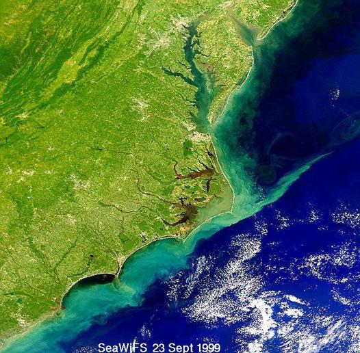
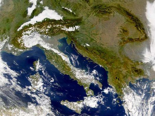
9


10 (Satellite photo courtesy NASA) Here are a few interesting pictures of wind erosion as well: See if you can identify the location and the extent of wind-blown debris.
 The 1997 Red River flood might be a good case study, if satellite images are available.")
11 Assignment: 1. Find erosion statistics for North Dakota: How much soil is lost per year by water erosion and by wind erosion? What is the tolerable limit set forth by the USDA? 2. Find satellite images of sedimentation in rivers in the Midwest (North Dakota if possible.) The 1997 Red River flood might be a good case study, if satellite images are available.
Page 1. Name:
 Name: 7574-1 - Page 1 1) The diagram below shows the result of leaving an empty, dry clay flowerpot in a full container of water for a period of time. The water level in the container dropped to level
The soil is a very. The soil can. The manure. Soil Characteristics. effective manure treatment system if manures are applied at the proper rate.
 The soil is a very effective manure treatment system if manures are applied at the proper rate. The soil can filter pollutants and prevent them from reaching groundwater. The manure application rate should
Lecture 20: Groundwater Introduction
 Lecture 20: Groundwater Introduction Key Questions for Groundwater 1. What is an aquifer? 2. What is an unconfined aquifer? 3. What is groundwater recharge? 4. What is porosity? What determines the magnitude
General Groundwater Concepts
 General Groundwater Concepts Hydrologic Cycle All water on the surface of the earth and underground are part of the hydrologic cycle (Figure 1), driven by natural processes that constantly transform water
Deep River-Portage Burns Waterway Watershed 2015
 2.4 Soils Soil development is the product of the interaction of parent material, topography, climate, organisms and time. Understanding the types of soils that exist within a watershed and their characteristics
WAT-E Physical and Chemical Treatment of Water and Waste Filtration. Adjunct Prof. Riina Liikanen
 WAT-E2120 - Physical and Chemical Treatment of Water and Waste Filtration Adjunct Prof. Riina Liikanen Content / Learning outcomes Overview of granular media filtration Removal and transport mechanisms
GEL Hydrogeology (Groundwater) LAB 2: POROSITY & HYDRAULIC CONDUCTIVITY - Porosity Segment - Grade: /25
 LAB 2: POROSITY & HYDRAULIC CONDUCTIVITY - Porosity Segment - Grade: /25") GEL 4250 - Hydrogeology (Groundwater) LAB 2: POROSITY & HYDRAULIC CONDUCTIVITY - Porosity Segment - Name: Section: Grade: /25 COMPLETE & TURN IN ONLY PAGES THAT HAVE A FIELD FOR YOUR NAME. ALL OTHER PAGES
GEL 4250 - Hydrogeology (Groundwater) LAB 2: POROSITY & HYDRAULIC CONDUCTIVITY - Porosity Segment - Name: Section: Grade: /25 COMPLETE & TURN IN ONLY PAGES THAT HAVE A FIELD FOR YOUR NAME. ALL OTHER PAGES
LAKE COUNTY HYDROLOGY DESIGN STANDARDS
 LAKE COUNTY HYDROLOGY DESIGN STANDARDS Lake County Department of Public Works Water Resources Division 255 N. Forbes Street Lakeport, CA 95453 (707)263-2341 Adopted June 22, 1999 These Standards provide
RUNNING WATER AND GROUNDWATER
 NAME RUNNING WATER AND GROUNDWATER I. Introduction In this exercise we will investigate various features associated with streams and groundwater. Our drinking water ultimately comes from either streams
groundwater. Because watersheds are complex systems, each tends to respond differently to natural or human activities.
 The private development of Altos del María is located at an altitude between 550 and 1,000 meters above sea level in the environmentally sensitive Cordillera Central of Panama that separates the Pacific
7-4 Soil. By Cyndee Crawford September 2014
 7-4 Soil By Cyndee Crawford September 2014 Soil Table of Contents 28.Chemical Weathering Lab 29.What is a Watershed? / Watershed Demo 30.Groundwater Layers Book 31.Groundwater Notes 32.What is an aquifer?
1. Apply knowledge of the controlling variables for groundwater flow. 2. Demonstrate groundwater flow direction based on hydraulic head observations.
 .9-12 HYDRAULIC HEAD SUBJECTS: TIME: Science (Physical Science, Physics), Math 1 class period MATERIALS: Copies of student sheets and background information OBJECTIVES The student will do the following:
Lecture 11: Water Flow; Soils and the Hydrologic Cycle
 Lecture 11: Water Flow; Soils and the Hydrologic Cycle Water Flow in Soils Types of Water Flow in Soil Saturated flow: Soil pores completely filled with water; controlled by the hydrostatic potential After
POROSITY, SPECIFIC YIELD & SPECIFIC RETENTION. Physical properties of
 POROSITY, SPECIFIC YIELD & SPECIFIC RETENTION Porosity is the the ratio of the voids to the total volume of an unconsolidated or consolidated material. Physical properties of n = porosity as a decimal
Groundwater 3/16/2010. GG22A: GEOSPHERE & HYDROSPHERE Hydrology
 GG22A: GEOSPHERE & HYDROSPHERE Hydrology Definitions Groundwater Subsurface water in soil or rock that is fully saturated. Aquifer Contains enough saturated material to yield significant quantities of
PERMEABILITY OF SOIL
 PERMEABILITY OF SOIL INDEX Introduction Importance of Permeability Darcy s law Factors affecting permeability of soil Laboratory Testing to find coefficient of permeability INTRODUCTION Definition It is
Lecture 21: Groundwater: Hydraulic Conductivity
 Lecture 21: Groundwater: Hydraulic Conductivity Key Questions 1. What causes groundwater to move? 2. What is the hydraulic conductivity? 3. What is Darcy s Law? 4. How is groundwater velocity estimated?
Precipitation Surface Cover Topography Soil Properties
 Precipitation Surface Cover Topography Soil Properties Intrinsic capacity of rainfall to cause erosion Influenced by Amount, intensity, terminal velocity, drop size and drop size distribution of rain.
Best Practices for Building High-Performance Resource Roads. Road Drainage. Developed by: The Roads and Infrastructure Group
 Best Practices for Building High-Performance Resource Roads Road Drainage Developed by: The Roads and Infrastructure Group THIS GUIDE IS INTENDED FOR EQUIPMENT OPERATORS CONSTRUCTION CONTRACTORS FIELD
What is the Vadose Zone? Why Do We Care? Tiffany Messer Assistant Professor Biological Systems Engineering School of Natural Resources University of
 What is the Vadose Zone? Why Do We Care? Tiffany Messer Assistant Professor Biological Systems Engineering School of Natural Resources University of Nebraska-Lincoln Learning Objectives History of Vadose
The Construction General Permit and Erosion Prevention and Sedimentation Control
 The Construction General Permit and Erosion Prevention and Sedimentation Control Presented at the Tennessee Gas Association Conference April 23, 2008 More than thirty years ago, two-third of the nation's
INTRODUCTION AND BACKGROUND
 INTRODUCTION AND BACKGROUND 1.1 Introduction This Erosion Prevention and Sediment Control (EPSC) Manual provides technical guidance for the design, installation, maintenance, and inspection of temporary
6.0 SITE EROSION POTENTIAL AND EVALUATION. 6.1 General
 6.0 SITE EROSION POTENTIAL AND EVALUATION 6.1 General SECTION 6 - SITE EROSION POTENTIAL AND EVALUATION The foremost challenge facing the designer is to correctly assess the erosion potential resulting
Ponds. Pond A water impoundment made by excavating a pit, or constructing a dam or an embankment.
 POND SITE SELECTION AND CONSTRUCTION Uses, Planning, & Design David Krietemeyer Area Engineer USDA-NRCS June 20, 2008 Uses Considerations for Location of Commonly Used Terms Pond A water impoundment made
CONTROL OF WETLAND HYDROLOGY BY BIOTIC PROCESSES
 HANDOUT # 2 (For 10/6 and 10/8 2004) ESP 155 Wetland Ecology, Fall 2004 Hydrology WETLAND HYDROLOGY Basic terms & concepts - most important determinant for establishing and maintenance of specific types
Rock Sock (RS) Rock Sock height.
 Rock Sock height.") Rock Sock (RS) SC-5 Description A rock sock is constructed of gravel that has been wrapped by wire mesh or a geotextile to form an elongated cylindrical filter. Rock socks are typically used either as
Rock Sock (RS) SC-5 Description A rock sock is constructed of gravel that has been wrapped by wire mesh or a geotextile to form an elongated cylindrical filter. Rock socks are typically used either as
Water Budget IV: Soil Water Processes P = Q + ET + G + ΔS
 Water Budget IV: Soil Water Processes P = Q + ET + G + ΔS Infiltration Infiltration capacity: The maximum rate at which water can enter soil. Infiltration capacity curve: A graph showing the time-variation
4. Ponds and infiltration BMPs can achieve 60 to 100% removal efficiencies for sediment.
 Landscape BMPs For the purposes of this project, preventive measures have been categorized into two categories: landscape BMPs and source prevention BMPs. Landscape BMPs includes both vegetative practices
9/9/ Basic Types of Rocks. Porosity of Earth Materials
 3 Basic Types of Rocks Porosity of Earth Materials Igneous rocks: crystalline solids which form directly from the cooling of magma. Example: granite. Sedimentary rocks: formed from material deposited as
ENGINEERING HYDROLOGY
 ENGINEERING HYDROLOGY Prof. Rajesh Bhagat Asst. Professor Civil Engineering Department Yeshwantrao Chavan College Of Engineering Nagpur B. E. (Civil Engg.) M. Tech. (Enviro. Engg.) GCOE, Amravati VNIT,
Lecture 6: Soil Water
 6-1 GEOG415 Lecture 6: Soil Water Infiltration Movement of water into soil. Importance? - flood prediction -erosion -agriculture - water resources Infiltration capacity Expressed in the same unit as rainfall
Soil Water Relationship. Dr. M. R. Kabir
 CHAPTER 4 Soil Water Relationship Dr. M. R. Kabir Professor and Head, Department of Civil Engineering University of Asia Pacific (UAP), Dhaka LECTURE 10 Introduction Root zone (depth of soil penetrated
CHAPTER 13 OUTLINE The Hydrologic Cycle and Groundwater. Hydrologic cycle. Hydrologic cycle cont.
 CHAPTER 13 OUTLINE The Hydrologic Cycle and Groundwater Does not contain complete lecture notes. To be used to help organize lecture notes and home/test studies. Hydrologic cycle The hydrologic cycle is
Freshwater. 260 Points Total
 9 SURFACE WATER SECTION 9.1 Surface Water Movement In your textbook, read about surface water and the way in which it moves sediment. Complete each statement. (13 points) 1. An excessive amount of water
WASTEWATER TREATMENT (1)
") Wastewater Engineering (MSc program) WASTEWATER TREATMENT (1) Prepared by Dr.Khaled Zaher Assistant Professor, Public Works Engineering Department, Faculty of Engineering, Cairo University Wastewater Flow
Wastewater Engineering (MSc program) WASTEWATER TREATMENT (1) Prepared by Dr.Khaled Zaher Assistant Professor, Public Works Engineering Department, Faculty of Engineering, Cairo University Wastewater Flow
Agronomy 406 World Climates
 Agronomy 406 World Climates February 13, 2018 Hydrologic cycle. Team 4 Climate News presentation this Thursday. Review: METED module, Understanding the Hydrologic Cycle Active review session for the midterm
The Relationship between the Properties and Features of Wetland Soils and the Adjacent Uplands
 The Relationship between the Properties and Features of Wetland Soils and the Adjacent Uplands By USDA Natural Resources Conservation Service Connecticut Staff Wetlands and watercourses are features of
Preliminary assessment of soil erodibility can be investigated with soil plasticity properties (Section 4.4.3).
.") 6.0 SITE EROSION POTENTIAL 6.1 General The foremost challenge facing the designer is to correctly assess the erosion potential resulting from the construction activities. The site erosion potential is
6.0 SITE EROSION POTENTIAL 6.1 General The foremost challenge facing the designer is to correctly assess the erosion potential resulting from the construction activities. The site erosion potential is
CE 240 Soil Mechanics & Foundations Lecture 4.3. Permeability I (Das, Ch. 6)
") CE 240 Soil Mechanics & Foundations Lecture 4.3 Permeability I (Das, Ch. 6) Outline of this Lecture 1. Permeability in Soils 2. Bernoulli s Equation 3. Darcy s Law 4. Hydraulic Conductivity 5. Hydraulic
CE 240 Soil Mechanics & Foundations Lecture 4.3 Permeability I (Das, Ch. 6) Outline of this Lecture 1. Permeability in Soils 2. Bernoulli s Equation 3. Darcy s Law 4. Hydraulic Conductivity 5. Hydraulic
Bench terraces on loess soil China - 土坎梯田, 梯地
 Bench terraces on loess soil China - 土坎梯田, 梯地 A Terrace is a structural SLM practice with a raised flat platform built on the slope to reduce soil loss and runoff on the slope, increase the rainfall infiltration
George Hild Hild & Associates, Inc. River Falls, WI
 George Hild Hild & Associates, Inc. River Falls, WI Permitting and Enforcement The Dynamics are Changing! New developments: EPA proposal entitled Effluent Limitation Guidelines and Standards for the Construction
Highway Surface Drainage
 Highway Surface Drainage R obert D. M iles, Research Engineer Joint Highway Research Project, and Assistant Professor of Highway Engineering, School of Civil Engineering Purdue University IN T R O D U
FACT FLASH. 5: Groundwater. What is groundwater? How does the ground store water? Fact Flash 5: Groundwater
 FACT FLASH 5: Groundwater What is groundwater? Groundwater is fresh water (from rain or melting ice and snow) that soaks into the soil and is stored in the tiny spaces (pores) between rocks and particles
Storm Drain Inlet Protection for Construction Sites (1060)
") Storm Drain Inlet Protection for Construction Sites (1060) Wisconsin Department of Natural Resources Conservation Practice Standard I. Definition A temporary device installed in or around a storm drain
Storm Drain Inlet Protection for Construction Sites (1060) Wisconsin Department of Natural Resources Conservation Practice Standard I. Definition A temporary device installed in or around a storm drain
3.11 Sand Filter Basin
 3.11 Sand Filter Basin Type of BMP Priority Level Treatment Mechanisms Maximum Drainage Area Flow-Through Treatment Priority 3 Treatment Control BMP Filtration 25 acres Description The Sand Filter Basin
Name Lab Section Date. Sediment Lab
 Name Lab Section Date. Investigating Stokes Law Sediment Lab ds = density of solid, g/cm dw = density of water, g/cm g = gravity, 980 cm/second 2 D = particle diameter in centimeters μ = molecular viscosity,
Introduction to Land Surface Modeling Hydrology. Mark Decker
 Introduction to Land Surface Modeling Hydrology Mark Decker (m.decker@unsw.edu.au) 1) Definitions 2) LSMs 3) Soil Moisture 4) Horizontal Fluxes 5) Groundwater 6) Routing Outline 1) Overview & definitions
Soil Mechanics FLUID FLW IN SOIL ONE DIMENSIONAL FLOW. Tikrit University. College of Engineering Civil engineering Department
 Tikrit University FLUID FLW IN SOIL ONE DIMENSIONAL FLOW College of Engineering Civil engineering Department Soil Mechanics 3 rd Class Lecture notes Up Copyrights 2016 Soil is a three phase medium --------
3/7/ Basic Types of Rocks. A Brief Review of Physics
 A Brief Review of Physics Energy is the capacity to do work. Work is equal to the product of the net force applied to a fluid and the distance through which the force moves: W = F l W is work [M 2 T -2
Sherman Library Maintenance Handbook for Porous Asphalt
 Sherman Library Maintenance Handbook for Porous Asphalt Porous asphalt systems are an effective means of stormwater management. Unlike traditional pavements, rainfall drains through the pavement surface
Hydrology of the West Campus, SUNY Stony Brook
 Hydrology of the West Campus, SUNY Stony Brook Andrew Tuomey and Steven Gessler Summer 1998 Link here to get a printable double sided brochure of this walk on 8.5 x 14 inch paper. Some of the images are
Shelbyville, Kentucky Stormwater Best Management Practices (BMPs) Stormwater Pollution Treatment Practices (Structural) DRAFT
 Stormwater Pollution Treatment Practices (Structural) DRAFT") Shelbyville, Kentucky Stormwater Best Management Practices (BMPs) Stormwater Pollution Treatment Practices (Structural) Activity: Infiltration Systems PLANNING CONSIDERATIONS: Design Life: Short IS Acreage
Shelbyville, Kentucky Stormwater Best Management Practices (BMPs) Stormwater Pollution Treatment Practices (Structural) Activity: Infiltration Systems PLANNING CONSIDERATIONS: Design Life: Short IS Acreage
Stability Analysis of Tailings Dam under Muddy Water Infiltration
 International Conference on Architectural, Civil and Hydraulics Engineering (ICACHE 2015) Stability Analysis of Tailings Dam under Muddy Water Infiltration Zhi-fei SONG1a, Fa-liang ZHAO2b,Qin-huan CUI3,Jian-qiang
Civil Engineering Department College of Engineering
 Civil Engineering Department College of Engineering Course: Soil Mechanics (CE 359) Lecturer: Dr. Frederick Owusu-Nimo What is permeability? A measure of how easily a fluid (e.g., water) can pass through
Laboratory Assignment #3
 UVIVERSITY OF IDAHO CE326/BAE356/FOR463 HYDROLOGIC MEASUREMENT TECHNIQUES Laboratory Assignment #3 Student Name: XXXXX Title: Infiltration Laboratory Date of Exercise: 3 October 200X Date of Submission:
A MODEL FOR SOIL OXYGEN DELIVERY TO WASTEWATER INFILTRATION SURFACES. J. Erickson, E. J. Tyler* ABSTRACT
 #4.44 A MODEL FOR SOIL OXYGEN DELIVERY TO WASTEWATER INFILTRATION SURFACES J. Erickson, E. J. Tyler* ABSTRACT Soil could accept onsite wastewater at rates two to three orders of magnitude higher than the
AP Environmental Science
 AP Environmental Science Types of aquatic life zones MARINE Estuaries coral reefs mangrove swamps neritic zone pelagic zone FRESHWATER lakes and ponds streams and rivers wetlands Distribution of aquatic
CHAPTER ONE : INTRODUCTION
 CHAPTER ONE : INTRODUCTION WHAT IS THE HYDROLOGY? The Hydrology means the science of water. It is the science that deals with the occurrence, circulation and distribution of water of the earth and earth
2015 International SWAT Conference Sardinia, Italy Date: (24 th June 2015)
") 2015 International SWAT Conference Sardinia, Italy Date: (24 th June 2015) By Pratiksha Jain Research Scholar Remote Sensing Applications Group Department of Civil Engineering Indian Institute of Technology
2015 International SWAT Conference Sardinia, Italy Date: (24 th June 2015) By Pratiksha Jain Research Scholar Remote Sensing Applications Group Department of Civil Engineering Indian Institute of Technology
Soil Physical Properties and Wastewater Treatment
 Soil Physical Properties and Wastewater Treatment John R. Buchanan, Ph.D., P. E. Associate Professor Biosystems Engineering and Soil Science Department Soil Physical Properties and Wastewater Treatment
Black River Watershed Management Plan Plan
 Black River Watershed Management Plan Plan Final Report Part II: Appendices May 2010 This watershed management plan was prepared for the New York State Department of State Division of Coastal Resources
11:375:360 Soils & Water
 11:375:360 Soils & Water Instructor: Dr. Daniel Giménez; gimenez@envsci.rutgers.edu Teaching Assistant: Wen Liu; wenliu@eden.rutgers.edu Text Brady, N. C. and R. R. Weil. 2002. Elements of the Nature and
Water Runoff and the Environment
 This guided activity explores the process of erosion and pollution caused by water runoff, using 3D Molecular Design s and paper clips. It also demonstrates how protective covers such as perennial grasses
Atterberg limits Clay A Clay B. Liquid limit 44 % 55% Plastic limit 29% 35% Natural water content 30% 50%
 CE 6405 SOIL MECHANICS UNIT I INTRODUCTION Part A 1. Distinguish between Residual and Transported soil. 2. Give the relation between γ sat, G, γ w and e 3. A compacted sample of soil with a bulk unit weight
Standards for Soil Erosion and Sediment Control in New Jersey May 2012 STANDARD FOR RIPRAP. Conditions Where Practice Applies
 STANDARD FOR RIPRAP Definition A layer of loose rock, aggregate, bagged concrete, gabions, or concrete revetment blocks placed over an erodible soil surface. Purpose The purpose of riprap is to protect
Topic 3, Subtopic A of Review Handbook or Chapter 10 of Earth Science Book. 97% of Earth s water is found as saltwater in Earth s oceans.
 Topic 3, Subtopic A of Review Handbook or Chapter 10 of Earth Science Book Groundwater 97% of Earth s water is found as saltwater in Earth s oceans. That leaves only 3% for freshwater! But 90% of the freshwater
Movement and Storage of Groundwater The Hydrosphere
 Movement and Storage of Groundwater The Hydrosphere The water on and in Earth s crust makes up the hydrosphere. About 97 percent of the hydrosphere is contained in the oceans. The water contained by landmasses
Laboratory Assignment #3
 UVIVERSITY OF IDAHO CE326/BAE356/FOR463 HYDROLOGIC MEASUREMENT TECHNIQUES Laboratory Assignment #3 Student Name: XXXXX Title: Infiltration Laboratory [Note to Students: This is provided as a general example
East Maui Watershed Partnership Adapted from Utah State University and University of Wisconsin Ground Water Project Ages 7 th -Adult
 INTRODUCTION What is groundwater? Water contained in saturated soil and rock materials below the surface of the earth. It is not NEW water, but is recycled water through the hydraulic cycle. The source
Science 8 Chapter 1 Section 1
 Science 8 Chapter 1 Section 1 Distribution of Water (pp. 8-13) How much fresh water do we have? The vast majority of water on Earth, about 97 percent, is salt water Two thirds of that fresh water supply
Soil Permeability Demonstration
 Soil Permeability Demonstration Grade Level: 6-12 Subject Area: Soil science, Aquaculture Time: This will take one hour to drill holes in the bucket and acquire the various soils. This will take one hour
LINED WATERWAY OR OUTLET (Feet) Code 468
 Code 468") LINED WATERWAY OR OUTLET (Feet) Code 468 Natural Resources Conservation Service Conservation Practice Standard I. Definition A waterway or outlet having an erosion-resistant lining of concrete, stone,
LINED WATERWAY OR OUTLET (Feet) Code 468 Natural Resources Conservation Service Conservation Practice Standard I. Definition A waterway or outlet having an erosion-resistant lining of concrete, stone,
PRACTICE NOTE 1: In Situ Measurement of Hydraulic Conductivity
 CONDITION ASSESSMENT AND PERFORMANCE EVALUATION OF BIORETENTION SYSTEMS PRACTICE NOTE 1: In Situ Measurement of Hydraulic Conductivity Belinda Hatt, Sebastien Le Coustumer April 2008 The Facility for Advancing
PE Exam Review - Geotechnical
 PE Exam Review - Geotechnical Resources and Visual Aids Item Page I. Glossary... 11 II. Parameters... 9 III. Equations....11 IV. Tables, Charts & Diagrams... 14 1. Module 1 - Soil Classification... 14
Trenches combined with living hedges or grass lines Rwanda - Imiringoti
 Trenches combined with living hedges or grass lines Rwanda - Imiringoti Trenches combined with living hedges or grass lines are slow-forming terraces to control soil erosion by changing the length of the
Suggested Stormwater Management Practices For Individual House Lots
 Suggested Stormwater Management Practices For Individual House Lots These practices are necessary to satisfy the water quantity and water quality criteria of the Rappahannock Stormwater Ordinance. These
Flow Diversion Banks: On grassed slopes
 Flow Diversion Banks: On grassed slopes DRAINAGE CONTROL TECHNIQUE Low Gradient Velocity Control Short Term Steep Gradient Channel Lining Medium-Long Term Outlet Control Soil Treatment Permanent [1] [1]
Section 208. SOIL EROSION AND SEDIMENTATION CONTROL
 208.01 Section 208. SOIL EROSION AND SEDIMENTATION CONTROL 208.01. Description. This work consists of installing and maintaining erosion and sedimentation controls to minimize soil erosion and control
FLOW IN POROUS MEDIA LUÍS RIBEIRO INSTITUTO SUPERIOR TECNICO UNIVERSITY OF LISBON
 FLOW IN POROUS MEDIA LUÍS RIBEIRO INSTITUTO SUPERIOR TECNICO UNIVERSITY OF LISBON Where does groundwater flow? How water flows? Groundwater moves from areas of high hydraulic head to areas of low hydraulic
Agry 560 Exam November 7, 2002 (135 points) (10 pages)
 (10 pages)") 1 Agry 560 Exam November 7, 2002 (135 points) (10 pages) Name (4) 1. In the auger-hole method for measuring saturated hydraulic conductivity below a water table, what is actually measured? a) infiltration
1 Agry 560 Exam November 7, 2002 (135 points) (10 pages) Name (4) 1. In the auger-hole method for measuring saturated hydraulic conductivity below a water table, what is actually measured? a) infiltration
Activity 1: Flood Storage
 Activity 1: Flood Storage Overview Background Students will observe how different soil components peat, sand, gravel, and potting soil vary in their capacity to absorb and hold water. They will observe
Loss Control TIPS Technical Information Paper Series
 Loss Control TIPS Technical Information Paper Series Innovative Safety and Health Solutions SM Understanding Subsidence Subsidence of the land, which is defined as the loss of surface elevation due to
Watershed Systems & Impairments
 Watershed Systems & Impairments Environmental Stewards Program ~ 2014 Lisa Galloway Evrard Senior Program Coordinator Rutgers Cooperative Extension Water Resources Program Part I: Overview of Watershed
Block & Aggregate Drop Inlet Protection
 Block & Aggregate Drop Inlet Protection SEDIMENT CONTROL TECHNIQUE Type 1 System Sheet Flow Sandy Soils Type 2 System [1] Concentrated Flow Clayey Soils Type 3 System Supplementary Trap Dispersive Soils
Properties of Water. Their shapes change when they are in different containers. Their volumes stay the same in any container.
 Name: Date: 1. Which statement correctly describes both gases and liquids? Their shapes stay the same in any container. Their shapes change when they are in different containers. Their volumes stay the
Saturated Buffer. Subsurface Drainage PURPOSE N REDUCTION LOCATION COST BARRIERS
 Saturated Buffer To intercept tile drainage prior to discharging to surface waters and redistribute the water laterally in the soil profile of the streamside buffer. Subsurface drainage, also known as
The Hydrosphere. Introduction To Surface Water. What Do You Think?
 Introduction To Surface Water Unit Essential Questions: How does the Earth cycle its water through its major reservoirs? How does society s use of resources affect water quality? Presentation Objectives:
Degradation of the resource Fertility loss Organic matter Tilth degradation. Water quality Sediment Nutrients
 Near Blue River ca. 1980 Degradation of the resource Fertility loss Organic matter Tilth degradation Water quality Sediment Nutrients Program cost Cheaper to prevent Still expensive Long-term productivity
2012 Soil Mechanics I and Exercises Final Examination
 2012 Soil Mechanics I and Exercises Final Examination 2013/1/22 (Tue) 13:00-15:00 Kyotsu 155 Kyotsu 1 Kyotsu 3 W2 Lecture room Attention: There are four questions and four answer sheets. Write down your
Ultra Thin Flat Heat Pipes
 Ultra Thin Flat Heat Pipes for Thermal Management of Electronics Introduction The decrease in size of the new generation of portable electronic devices imposes a severe constraint on their incorporated
The Water Cycle. 1. The diagram below is a cross-sectional view of rain falling on a farm field and then moving to the water table.
 1. The diagram below is a cross-sectional view of rain falling on a farm field and then moving to the water table. Which word best describes the movement of the rainwater through zone A? A. runoff B. saturation
Flow Diversion Banks: On earth slopes
 Flow Diversion Banks: On earth slopes DRAINAGE CONTROL TECHNIQUE Low Gradient Velocity Control Short Term Steep Gradient Channel Lining Medium-Long Term Outlet Control Soil Treatment Permanent [1] [1]
Gabions. Introduction
 Gabions Introduction 1. A gabion is a wire mesh cage or basket filled with stones. Gabions are useful in construction works, for example to protect earth embankments, to line channels, to manage or divert
A-2. Soils. Soil Media. Chapter Contents. Soil Media In-situ Soil Testing Separation from Seasonal High Water Table (SHWT)
") A-2. Soils Chapter Contents Soil Media In-situ Soil Testing Separation from Seasonal High Water Table (SHWT) Importance of Soil Composition in SCMs The soil composition of many stormwater SCMs also is
A-2. Soils Chapter Contents Soil Media In-situ Soil Testing Separation from Seasonal High Water Table (SHWT) Importance of Soil Composition in SCMs The soil composition of many stormwater SCMs also is
Chapter 3 THEORY OF INFILTRATION. 3.1 General
 Chapter 3 THEORY OF INFILTRATION 3.1 General Water entering the soil at the surface of ground is termed as infiltration. It replaces the soil moisture deficit and the excess water moves downward by the
Inlet Protection. Fe= (Depends on soil type)
") 3.4 DESIGN CRITERIA: KEY CONSIDERATIONS Evaluate drainage patterns to ensure inlet protection will not cause flooding of roadway, property or structures Never block entire inlet opening Size according
3.4 DESIGN CRITERIA: KEY CONSIDERATIONS Evaluate drainage patterns to ensure inlet protection will not cause flooding of roadway, property or structures Never block entire inlet opening Size according
10(a) Bridge and culvert design information
 Bridge and culvert design information") 10(a) Bridge and culvert design information The following information is required to accompany resource consent applications for bridges or culverts on waterways. Please answer all questions if possible.
10(a) Bridge and culvert design information The following information is required to accompany resource consent applications for bridges or culverts on waterways. Please answer all questions if possible.
Low Gradient Velocity Control Short Term Steep Gradient Channel Lining Medium-Long Term Outlet Control Soil Treatment Permanent [1]
![Low Gradient Velocity Control Short Term Steep Gradient Channel Lining Medium-Long Term Outlet Control Soil Treatment Permanent [1]](/thumbs/83/88729038.jpg "Low Gradient Velocity Control Short Term Steep Gradient Channel Lining Medium-Long Term Outlet Control Soil Treatment Permanent [1]") Diversion Channels DRAINAGE CONTROL TECHNIQUE Low Gradient Velocity Control Short Term Steep Gradient Channel Lining Medium-Long Term Outlet Control Soil Treatment Permanent [1] [1] The design of permanent
Diversion Channels DRAINAGE CONTROL TECHNIQUE Low Gradient Velocity Control Short Term Steep Gradient Channel Lining Medium-Long Term Outlet Control Soil Treatment Permanent [1] [1] The design of permanent
Groundwater Hydrology
 Groundwater Hydrology Þröstur Þorsteinsson Environment and Natural Resources, University of Iceland Why study groundwater? Important source of fresh water Large portion of the Earth s fresh water as groundwater
Fabric Drop Inlet Protection
 Fabric Drop Inlet Protection SEDIMENT CONTROL TECHNIQUE Type 1 System Sheet Flow Sandy Soils Type 2 System Concentrated Flow Clayey Soils [1] Type 3 System Supplementary Trap Dispersive Soils [1] Block