Unimpaired Flows vs. Natural Flows to the Sacramento San Joaquin Delta: What s the Difference?
|
|
|
- Dinah Morton
- 5 years ago
- Views:
Transcription
1 Unimpaired Flows vs. Natural Flows to the Sacramento San Joaquin Delta: What s the Difference? California Water and Environmental Modeling Forum Folsom, California March 9-11, 2015 Tariq Kadir and Guobiao Huang (CA DWR)
2 Acknowledgements Can Dogrul (CA DWR) Charles Brush (CA DWR) Jane Schafer-Kramer (CA DWR) Francis Chung (CA DWR)
3 Outline Unimpaired flow and natural flow (California) Unimpairment process and limitations DWR Natural Flow Simulations (Central Valley) Comparison of unimpaired flows and natural flows Sensitivity Analyses Lakes and wetlands animation Final comments and work under way
4 Interest Interested in an index to reflect the water supply of the areas in the Central Valley tributary to the Sacramento San Joaquin Delta for a given hydrological (precipitation) trace Computing inflows into and outflows from the Sacramento San Joaquin Delta after removing impacts of human development (land use based demands and land use alterations) for a given hydrological (precipitation) trace
5 Definitions As defined in Wikipedia Unimpaired runoff, also known as full natural flow, is a hydrology term that is used to describe the natural runoff of a watershed or waterbody that would have occurred prior to anthropogenic or human influences on the watershed. Flow readings from river gauges are influenced by upstream diversions, impoundments, and many other alternations of the land that drains into a watershed or of alternatives of a river channel itself. Engineers estimate unimparied or natural runoff by estimating all of the effects of human "impairments" to flow and then removing these effects. Since these calculations involve many assumptions, they tend to be more accurate for either smaller watersheds or when expressed as longer period averages As defined by DWR (Division of Flood Management Snow Surveys) Flow readings from river gages are influenced by upstream diversions, impoundments, and other manmade alterations. The natural runoff at a gage is reconstructed by removing the effects of these "impairments." This calculation is done on a monthly basis for all major rivers in the state, and on a daily basis for a subset. The result is the "full natural flow,"

6 An Upper Watershed with No Development

7 A Watershed with Ag and Urban Development
8 Unimpairment Process For an upstream (uppermost) undeveloped watershed a good measure of the water supply (index) is precipitation/snowmelt runoff that shows in a watershed is the runoff that shows up at the outflow point In this case the runoff = stream flow measured/computed at the outflow location For an upstream (uppermost) developed watershed impacts of the development (reservoirs, diversions, returns, imports/exports, etc) have to be removed from the measured outflow to get the unimpaired flow There are two approaches to the unimpairment process: from the supply side perspective or from the demand sideperspective Both approaches have common elements. Main difference is in the unimpairment of depletions: Diversions vs. Land Use (crop acreages, unit ETc, soil moisture accounting)
9 Conceptual UF Estimation Procedure (Supply Side Perspective) Evaporation (E) Inflow (Q in ) Import (Q imp ) Change in Res. Storage ( S) Diversion/Export (Q div ) Gage Gauged outflow (Q out ) UF = Q out - Q imp + Q div + S + E 9
10 Example: San Joaquin River at Millerton Flow category Adjustment Flow description Source San Joaquin River below Friant Observed flow + Dam USGS gage + Friant-Kern Canal MI2 Diversion Storage gain + Madera Canal MI1 + Millerton Lake MIL (RECL.) + Florence Lake FLR + Lake Thomas A. Edison TAE + Huntington Lake HNT + Shaver Lake SHV + Mammoth Pool MPL + Redinger Lake RDN + Crane Valley (Bass Lake) CNV + Kerckhoff Reservoir KRH Evaporation + Millerton Lake MIL (RECL.) Unimpaired flow Sum San Joaquin River below Friant Dam SJF IMPORTANT: Removed diversions are not replaced with native vegetation! Outflow may be overestimated. 10
11 Unimpairment Process (Demand Side Perspective) This approach was used by DWR in developing the hydrological inputs for DWRSIM, CalSim-I and CalSim-II Starting with the outflow flow, the impairment builds back into the flow the impact of the agricultural and urban development from the using land use based estimation of consumptive use or depletions (reservoir storages, imports/exports are handled from the supply side point of view A key element in the procedure is that any land use (ag/urban) removed is then replaced with equal area native vegetation (which would have occurred had the land not been developed).


12 Watersheds Impact Downstream Areas In the Central Valley upper watersheds are connected to other areas below: not independent from each other
13 Issues to Consider Does the unimpairment process build back in native vegetation over developed ag/urband areas? If the outflow from the upper watershed becomes an inflow to a downstream watershed or area, that flow is a supply that can meet consumptive demands in the downstream area How is ground water and stream aquifer interaction handled? In addition to land use development, human-made levees built on top of natural levees channelize water downstream instead of over topping into adjacent areas
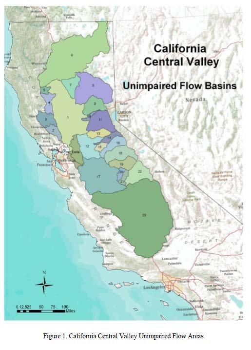
14 Published Unimpaired Flow Data
15 Natural Flow Simulation (Proposed Approach by DWR) For a given precipitation trace, if all anthropogenic influences (agricultural and urban development, reservoirs, levees, etc) are removed upstream of a location, and the landscape is replaced with native vegetative classes as existed prior to land use development, and allowances are made for overtopping of streams, and the physical processes of runoff, infiltration, stream-aquifer interaction, lakes are accounted for, the resulting flow will be an approximation of natural flow at that location. Objective is to compute stream flows under natural vegetative conditions for both upstream watersheds and downstream (valley floor) areas into and through the Delta


16 Simulating Natural Flows Three Phases of Flow: Upper watershed outflows, route through valley floor, route through the Delta
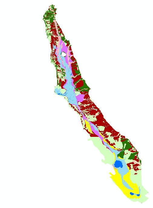
17 Native Vegetative Classes
18 Approach 1. SWAT daily models for 23 major upper watersheds calibrated and verified for with observed/computed data (monthly, spot check for daily). Minor upper/boundary watersheds modeled within C2VSIM. Compute daily runoffs = outflows. 2. Route upper watershed outflows to the Delta using daily C2VSIM: Land use: Native vegetation, riparian vegetation, wetlands and lakes (work by CSU and consultants for MWD) DEM: coarse grid (~ 5miles x 5 miles) Rating curves to allow water flow from streams to lakes/wetlands Connected lakes and wetlands (< 10 ft depth max) with flow back to streams Use ETc estimates (consultants for MWD) Carry out sensitivity runs by varying selected parameters IWFM version used allows for ground water uptake, riparian/vernal pools access to streams, interconnected lakes, and kinematic wave for routing in streams
19 Annual Water Budget (WY )
20 Annual Water Budget (WY 1977 Dry)

21 Annual Water Budget (WY 1995 Wet)
22 Comparison of Unimpaired Flows vs Simulated Natural Flows
23 Sensitivity Runs Combination of varying parameters and vernal pool simulations: ETc multiplier: 0.9 (1.0) Riparian vegetation extinction depths: (20 ft) 40 ft Vernal pools extinction depths: (15 ft) Vernal pools simulations: Access to only nearby streams Access to all streams in the vicinity No access to streams Summary results ( MAF/yr): Lower Bound Base Upper Bound Delta Inflow Delta Outflow

24 Comparison of Predevelopment Ground Water Elevations to USGS CVRASA1 (1989)
 Link to lakes")
25 Animation of Lakes Simulation Results This animation is only approximate; assumption is only if all nodes of the grid element is under water then element is animated as a covered with water (under representation) Link to lakes animation
26 Concluding Remarks and Future Work There is a difference between unimpaired flow and natural flow Natural flow simulations provide a better and more reliable estimates of stream flows at locations when upstream land use is under native vegetative conditions (for a given precipitation trace) DWR has developed upper watershed SWAT models to compute daily outflows for , and routes the water through the valley floor using C2VSIM and simulates inflows into the Delta and outflow from the Delta SWAT and C2VSIM models allow applications of future conditions to study impacts of climate change (precipitation, rising temperatures, Etc) Work is under way to prepare a report summarizing all unimpaired flows (WY ), simulated natural flows, and the listing the differences between them (Draft Spring 2015)
CVSIM: Linking C2VSIM with CVP-SWP Reservoir Operations
 CVSIM: Linking C2VSIM with CVP-SWP Reservoir Operations Tariq N. Kadir, Ph.D., P.E. California Department of Water Resources CWEMF 2018 Annual Meeting April 2, 2018 Acknowledgements Jay Lund UC Davis Department
Hydrology Forecasting using SWAT Hydrologic Models for the 2014 California Drought
 Hydrology Forecasting using SWAT Hydrologic Models for the 2014 California Drought Guobiao Huang and Francis Chung Bay-Delta Office CA Department of Water Resources CWEMF Annual Meeting March 10, 2015
The California Central Valley Groundwater-Surface Water Simulation Model. C2VSim Overview
 The California Central Valley Groundwater-Surface Water Simulation Model C2VSim Overview CWEMF C2VSim Workshop Charles Brush Modeling Support Branch, Bay-Delta Office California Department of Water Resources,
Camp Far West Hydroelectric Project Relicensing
 Camp Far West Hydroelectric Project Relicensing Water Operations Model FERC Project No. 2997 July 16, 2018 Overview Project and South Sutter Water District overview Operations model Overview Model Updates
Estimating Effect of Historical Warming on CalSim 3.0 Rim Inflow Hydrology with SWAT
 Estimating Effect of Historical Warming on CalSim 3.0 Rim Inflow Hydrology with SWAT Guobiao Huang, Hongbing Yin, Francis Chung and Z.. Richard Chen Bay-Delta Office CA Department of Water Resources CWEMF
DRAFT KERN GROUNDWATER AUTHORITY COORDINATION AGREEMENT COMPONENTS WHITE PAPER SERIES. Item D Total Water Use
 KERN GROUNDWATER AUTHORITY COORDINATION AGREEMENT COMPONENTS WHITE PAPER SERIES Item D Total Water Use Introduction There are seven components to Groundwater Sustainability Plan (GSP) coordination agreements.
1 THE USGS MODULAR MODELING SYSTEM MODEL OF THE UPPER COSUMNES RIVER
 1 THE USGS MODULAR MODELING SYSTEM MODEL OF THE UPPER COSUMNES RIVER 1.1 Introduction The Hydrologic Model of the Upper Cosumnes River Basin (HMCRB) under the USGS Modular Modeling System (MMS) uses a
Groundwater and Stream Interaction in California's Central Valley: Insights for Sustainable Groundwater Management
 Groundwater and Stream Interaction in California's Central Valley: Insights for Sustainable Groundwater Management Completed June 2014 Updated and Released February 2016 Prepared by: Prepared for: Funded
Appendix VI: Illustrative example
 Central Valley Hydrology Study (CVHS) Appendix VI: Illustrative example November 5, 2009 US Army Corps of Engineers, Sacramento District Prepared by: David Ford Consulting Engineers, Inc. Table of contents
Initial 2018 Restoration Allocation & Default Flow Schedule January 23, 2018
 Initial 2018 Restoration Allocation & Default Schedule January 23, 2018 Bureau of Reclamation 2800 Cottage Way, MP-170 Sacramento, California 95825 Introduction The following transmits the initial 2018
CALSIM II Sacramento River Basin Hydrology Enhancements
 CALSIM II Sacramento River Basin Hydrology Enhancements Andy Draper Walter Bourez - Montgomery Watson Harza - MBK Engineers February 26, 2004 Current representation Problems Solutions Work completed Possible
A Peer Review of IWFM and MODFLOW-Farm Process
 A Peer Review of IWFM and MODFLOW-Farm Process California Water and Environmental Modeling Forum Asilomar Conference Center, California February 22-24, 2010 Tariq Kadir (California Department of Water
Water and Power Policy Group
 Water and Power Policy Group Retrospective Analysis of Changed Central Valley Project and State Water Project Conditions Due to Changes in Delta Regulations January 213 Retrospective Analysis January 213
2015 Restoration Allocation and Default Flow Schedule January 20, 2015
 Bureau of Reclamation 00 Cottage Way, MP- Sacramento, California 01 January 0, 01 1 Introduction The following transmits the 01 to the Restoration Administrator for the San Joaquin River Restoration Program
Watersheds. A river is the report card for its watershed. Alan Levere. Arizona Water Issues 2010 The University of Arizona HWR203 1
 Watersheds A river is the report card for its watershed. Alan Levere 1 What separates watersheds? How do you identify watershed boundaries? Drainage Divides River Networks boto.ocean.washington.edu/gifs/purus.gif
ENGINEERING ECOSYSTEM RESTORATION
 APPENDIX D ENGINEERING ECOSYSTEM RESTORATION ENGINEERING APPENDIX FOR EXISTING CONDITION ANALYSIS FOR RISK INFORMED DECISION MAKING FOR PROJECT ALTERNATIVE SELECTION DELTA ISLANDS AND LEVEES FEASIBILITY
May 3, 2011 BUILDING STRONG BUILDING STRONG ALBUQUERQUE DISTRICT. US Army Corps of Engineers. US Army Corps of Engineers
 Upper Rio Grande Water Operations Model Present t& Future Work May 3, 2011 US Army Corps of Engineers US Army Corps of Engineers BUILDING STRONG ALBUQUERQUE DISTRICT URGWOM Website http://www.spa.usace.army.mil/urgwom/default.asp
Implementation of Agricultural Managed Aquifer Recharge in the Central Valley: Large Scale Long Term Success?
 Implementation of Agricultural Managed Aquifer Recharge in the Central Valley: Large Scale Long Term Success? Giorgos Kourakos, Helen Dahlke, Tiffany Kocis, Mehdi Ghasemizade, and Thomas Harter (Presenter)
Temperature Monitoring of the Cold Water Pool in Millerton Lake
 Study 5 Temperature Monitoring of the Cold Water Pool in Millerton Lake Final 2015 Monitoring and Analysis Plan January 2015 1.0 Temperature Monitoring of the Cold Water Pool in Millerton Lake 1.1 Statement
California s s Water Supplies and Uses
 California s s Water Supplies and Uses Presented to Delta Stewardship Council Presented by Joe Grindstaff September 21 1 Place to Place: Most precipitation falls in the mountains in the north and east
Using high flows from, or in anticipation of, rainfall or snowmelt, for managed aquifer recharge on agricultural lands and working landscapes
 Using high flows from, or in anticipation of, rainfall or snowmelt, for managed aquifer recharge on agricultural lands and working landscapes More competition over surface water storage Potential surface
Sacramento and San Joaquin Basins Study & Climate Adaptation Options
 Sacramento and San Joaquin Basins Study & Climate Adaptation Options Presentation to MCWRA and ACWA Region 3 March 11, 2014 v2 WaterSMART Basin Study Program Overview Basin Studies Authorized in SECURE
Chapter 5: Use of CALVIN in DSM2 Planning Studies
 Methodology for Flow and Salinity Estimates in the Sacramento-San Joaquin Delta and Suisun Marsh 24 th Annual Progress Report June 2003 Chapter 5: Use of CALVIN in DSM2 Planning Studies Author: Jamie Anderson
Technical Memorandum
 Specialists in Agricultural Water Management Serving Stewards of Western Water since 1993 To: From: Technical Memorandum Butte County Department of Water and Resource Conservation Davids Engineering Date:
Folsom Dam Water Control Manual Update
 Folsom Dam Water Control Manual Update Stakeholder Discussion October 31, 2013 Location: Tsakopoulos Library Galleria, East Room, 828 I Street, Sacramento US Army Corps of Engineers WELCOME & INTRODUCTIONS
Friant Dam and Millerton Reservoir
 San Joaquin River Restoration Program Floodplain Management Association Presentation SJRRP Update Continued: Impacts from Subsidence April 18, 2013 1 Friant Dam and Millerton Reservoir Completed in 1942
Forecast Informed Reservoir Operations (FIRO) ERDC Hydrologic Investigations
 ERDC Hydrologic Investigations") Forecast Informed Reservoir Operations (FIRO) ERDC Hydrologic Investigations Briefing, May 31, 2017 Background The US Army Corps of Engineers (USACE) operates reservoirs primarily for flood control, with
Forecast Informed Reservoir Operations (FIRO) ERDC Hydrologic Investigations Briefing, May 31, 2017 Background The US Army Corps of Engineers (USACE) operates reservoirs primarily for flood control, with
If you need this publication in alternate form, contact the Public Affairs Office at
 If you need this publication in alternate form, contact the Public Affairs Office at 1-800-272-8869. Table of Contents Volume 3 - Regional Reports Chapter 1: State Summary Chapter 2: North Coast Hydrologic
Report. Environmental Water Demands. Butte County Department of Water and Resource Conservation Integrated Water Resources Plan.
 Report Butte County Department of Water and Resource Conservation Integrated Water Resources Plan s June 2004 s Section 1 - Introduction 1.1 Project Description This project is a preliminary investigation
Technical Memorandum. Butte County Department of Water and Resource Conservation
 Butte County Department of Water and Resource Conservation Base Case and Water Management Scenario Simulations April 2008 Technical Memorandum Contents Section 1 Introduction Section 2 Base Case... 2-1
Analysis and Simulation of Conjunctive Water Use for Agricultural Settings with the Farm Process for MODLFOW
 Analysis and Simulation of Conjunctive Water Use for Agricultural Settings with the Farm Process for MODLFOW Randy Hanson 1, and Wolfgang Schmid 2 1 U.S. Geological Survey 2 University of Arizona Resource
San Antonio Water System Mitchell Lake Constructed Wetlands Below the Dam Preliminary Hydrologic Analysis
 San Antonio Water System enhancement. This recommendation was based on limited water quality data provided by SAWS and using a free-water surface constructed wetland with approximately 112 acres of wetted
Appendix 5G Comparison of FEIRS Alternative 4A Modeling Results to the California Water Fix Section BA Proposed Action Modeling Results
 Appendix G Comparison of FEIRS Alternative A Modeling Results to the California Water Fix Section BA Proposed Action Modeling Results 6 7 8 9 0 6 7 8 9 0 6 7 8 9 0 6 7 Appendix G Comparison of FEIRS Alternative
5. Basin Evaluation Salt and Nitrate Balance
 SNMP Attachment B, Section B.2.1.3 (originally Section 5 in CV-SALTS Phase 2 Conceptual Model Task 5 deliverables) 5. As part of the evaluation of water quality the SNMP requires loading estimates and
River Processes River action (fluvial)
") River action (fluvial) is probably the single most important geomorphic agent and their influence in geomorphology can hardly be overestimated. 1 To understand the complexity associated with river flow
River action (fluvial) is probably the single most important geomorphic agent and their influence in geomorphology can hardly be overestimated. 1 To understand the complexity associated with river flow
Hydrologic Characteristics of the Owens River Basin below the Upper Owens River
 Appendix T. Hydrologic Characteristics of the Owens River Basin below the Upper Owens River The hydrology of Mono Basin is described in detail in Chapter 3A. This appendix describes the Owens River basin
SACRAMENTO MUNICIPAL UTILITY DISTRICT UPPER AMERICAN RIVER PROJECT (FERC Project No. 2101) and
 and") SACRAMENTO MUNICIPAL UTILITY DISTRICT UPPER AMERICAN RIVER PROJECT (FERC Project No. 2101) and PACIFIC GAS AND ELECTRIC COMPANY CHILI BAR PROJECT (FERC Project No. 2155) HYDROLOGY TECHNICAL REPORT Devine
SACRAMENTO MUNICIPAL UTILITY DISTRICT UPPER AMERICAN RIVER PROJECT (FERC Project No. 2101) and PACIFIC GAS AND ELECTRIC COMPANY CHILI BAR PROJECT (FERC Project No. 2155) HYDROLOGY TECHNICAL REPORT Devine
Jose Gutierrez - Chief Operating Officer. Water Education Foundation, April 4,2019
 Jose Gutierrez - Chief Operating Officer Water Education Foundation, April 4,2019 Presentation Overview Who We Are CVP South of Delta Allocation Groundwater Conditions Sustainable Groundwater Management
Table of Contents. List of Tables
 Appendix B Evaluation of Potential Impacts of Cedar Springs Dam (Silverwood Lake) and Mojave River Dam on Downstream Mojave River Flows and Groundwater Recharge Table of Contents 1.1 Introduction... B1
Sacramento and San Joaquin river basins: Procedures for hydrologic analysis September 9, 2008
 Sacramento and San Joaquin river basins: Procedures for hydrologic analysis September 9, 2008 David Ford Consulting Engineers, Inc. 2015 J Street, Suite 200 Sacramento, CA 95811 Ph. 916.447.8779 Fx. 916.447.8780
New Investments in Water Portfolios
 California Water Plan Update 2010 New Investments in Water Portfolios California Water and Environmental Water Forum Annual Meeting February 27, 2007 Todd Hillaire hillaire@water.ca.gov California Department
Project Summary: - Hydrologic Models. - LiDAR Based - 10 Synthetic Events - No Historic Events - 100yr Runoff is Largest - Assumes Even Rainfall
 Project Summary: - Hydrologic Models Phase 2 Underway Nearly Completed (Park/Pembina EOY) - LiDAR Based - 10 Synthetic Events - No Historic Events - 100yr Runoff is Largest - Assumes Even Rainfall Phase
Chapter 1 Introduction
 Engineering Hydrology Chapter 1 Introduction 2016-2017 Hydrologic Cycle Hydrologic Cycle Processes Processes Precipitation Atmospheric water Evaporation Infiltration Surface Runoff Land Surface Soil water
Hydrology and Water Management. Dr. Mujahid Khan, UET Peshawar
 Hydrology and Water Management Dr. Mujahid Khan, UET Peshawar Course Outline Hydrologic Cycle and its Processes Water Balance Approach Estimation and Analysis of Precipitation Data Infiltration and Runoff
EXHIBIT ARWA-500 PART 2 TESTIMONY OF TOM GOHRING, P.E.
 EXHIBIT ARWA-500 PART 2 TESTIMONY OF TOM GOHRING, P.E. 1. I am the Executive Director of the Water Forum. I hold a Bachelor of Science degree in Agricultural Engineering from the California Polytechnic
2. Potential Extreme Peak Discharge in Texas
 2. Potential Extreme Peak Discharge in Texas This part of the work is focused on using GIS to apply the latest USGS peak discharge equations to create a 500m grid that stores the potential peak discharge
21st Century Climate Change In SW New Mexico: What s in Store for the Gila? David S. Gutzler University of New Mexico
 21st Century Climate Change In SW New Mexico: What s in Store for the Gila? David S. Gutzler University of New Mexico gutzler@unm.edu Silver City, NM June 5, 2008 Global Warming in the 20th/Early 21st
The Texas A&M University and U.S. Bureau of Reclamation Hydrologic Modeling Inventory (HMI) Questionnaire
 Questionnaire") The Texas A&M University and U.S. Bureau of Reclamation Hydrologic Modeling Inventory (HMI) Questionnaire May 4, 2010 Name of Model, Date, Version Number Dynamic Watershed Simulation Model (DWSM) 2002
The Texas A&M University and U.S. Bureau of Reclamation Hydrologic Modeling Inventory (HMI) Questionnaire May 4, 2010 Name of Model, Date, Version Number Dynamic Watershed Simulation Model (DWSM) 2002
HYDROLOGY STUDY STATUS REPORT
 Placer County Water Agency Middle Fork American River Project (FERC No. 2079) 2005-2006 HYDROLOGY STUDY STATUS REPORT Placer County Water Agency 144 Ferguson Road Auburn, CA 95604 September 2007 TABLE
HYDROLOGY REPORT HEACOCK & CACTUS CHANNELS MORENO VALLEY, CALIFORNIA NOVEMBER 2005 REVISED APRIL 2006 REVISED AUGUST 2006
 HYDROLOGY REPORT HEACOCK & CACTUS CHANNELS MORENO VALLEY, CALIFORNIA NOVEMBER 2005 REVISED APRIL 2006 REVISED AUGUST 2006 RIVERSIDE COUNTY FLOOD CONTROL AND WATER CONSERVATION DISTRICT TABLE OF CONTENTS
Hydraulic and Sediment Transport Modeling Strategy
 Appendix B Hydraulic and Sediment Transport May 2014 Technical Memorandum Channel Capacity Report September 2014 San Joaquin River Restoration Program Hydraulic and Sediment Transport The San Joaquin River
Distribution Restriction Statement Approved for public release; distribution is unlimited.
 CECW-EH-Y Regulation No. 1110-2-1464 Department of the Army U.S. Army Corps of Engineers Washington, DC 20314-1000 Engineering and Design HYDROLOGIC ANALYSIS OF WATERSHED RUNOFF Distribution Restriction
Prepared For: California Energy Commission Public Interest Energy Research Program
 DROUGHT ANALYSES OF THE CALIFONIA CENTRAL VALLEY SURFACE- GROUNDWATER-CONVEYANCE SYSTEM PIER PROJECT REPORT Arnold Schwarzenegger Prepared For: California Energy Commission Public Interest Energy Research
Hydrologic Engineering Center. Training Course on. Hydrologic Modeling with HEC-HMS. Davis, CA. Course Description
 Hydrologic Engineering Center Training Course on Hydrologic Modeling with HEC-HMS Davis, CA Course Description The course provides an introduction to HEC-HMS for new users, focusing both on using the program
Appendix B. Historic Groundwater Levels and Surface Water Flow
 5 6 7 Appendix B. Historic Groundwater Levels and Surface Water Flow This appendix describes the groundwater level and surface water flow data used to develop maps of depth to the water table, and for
Depletion Requiremements in California s Sustainable Groundwater Management Act
 Depletion Requiremements in California s Sustainable Groundwater Management Act A PROPOSED APPROACH FOR COMPLIANCE Environmental Defense Fund Maurice Hall Christina Babbitt Consultant Anthony M. Saracino
A Tale of Two Dams and a dry river. November 1, 2011 Planning, Resources and Technology Committee Mojave Water Agency
 A Tale of Two Dams and a dry river November 1, 2011 Planning, Resources and Technology Committee Mojave Water Agency The Mojave River Headwaters San Bernardino Mountains Terminus (mouth) Soda Lake (Baker,
Hydrologic Engineering Center. Training Course on. Hydrologic Modeling with HEC-HMS April 2018 Davis, CA. Course Description
 Hydrologic Engineering Center Training Course on Hydrologic Modeling with HEC-HMS 23-27 April 2018 Davis, CA Course Description The course provides an introduction to HEC-HMS for new users, focusing both
Comparative analysis of SWAT model with Coupled SWAT-MODFLOW model for Gibbs Farm Watershed in Georgia
 2018 SWAT INTERNATIONAL CONFERENCE, JAN 10-12, CHENNAI 1 Comparative analysis of SWAT model with Coupled SWAT-MODFLOW model for Gibbs Farm Watershed in Georgia Presented By K.Sangeetha B.Narasimhan D.D.Bosch
Hydrology for Folsom Dam Water Control Manual Update
 Hydrology for Folsom Dam Water Control Manual Update Brian Walker, EIT Civil Engineer, Hydrology Section U.S. Army Corps of Engineers Sacramento District 1325 J Street Sacramento, CA 95816 Tel: (916) 557-7376
4.5 WASTEWATER, STORM DRAINAGE, AND FLOODING
 4.5 WASTEWATER, STORM DRAINAGE, AND FLOODING INTRODUCTION This section addresses the potential wastewater, storm drainage, and flooding impacts resulting from development under the Draft General Plan.
Combining a Conceptual Hydrologic Model (SWAT) and a Hydrodynamic Model (Telemac 3D) to Simulate Reservoir Dynamics in. Eagle Creek Reservoir, Indiana
 and a Hydrodynamic Model (Telemac 3D) to Simulate Reservoir Dynamics in. Eagle Creek Reservoir, Indiana") Combining a Conceptual Hydrologic Model (SWAT) and a Hydrodynamic Model (Telemac 3D) to Simulate Reservoir Dynamics in Eagle Creek Reservoir, Indiana 1 Purpose of Modeling Effort Fate and Transport of
Combining a Conceptual Hydrologic Model (SWAT) and a Hydrodynamic Model (Telemac 3D) to Simulate Reservoir Dynamics in Eagle Creek Reservoir, Indiana 1 Purpose of Modeling Effort Fate and Transport of
The Future of Irrigated Agriculture: Where's the Water?
 The Future of Irrigated Agriculture: Where's the Water? California Colloquium on Water UC Berkley February 9 th 2010 David F. Zoldoske, Director Center for Irrigation Technology California State University,
5.3 Tuolumne River System and Downstream Water Bodies
 5.3 Tuolumne River System and Downstream Water Bodies Section 5.3 Subsections 5.3.1 Stream Flow and Reservoir Water Levels 5.3.2 Geomorphology 5.3.3 Surface Water Quality 5.3.4 Surface Water Supplies 5.3.5
MANZANITA LAKE PLANNING UNIT Willow Creek Watershed
 Existing Conditions & Uses Overview Area surrounding a small afterbay and creeks with ethnobotanical resources and valuable habitat 472 acres in Madera County; 337 acres outside the FERC boundary and 135
SECTION IV WATERSHED TECHNICAL ANALYSIS
 A. Watershed Modeling SECTION IV WATERSHED TECHNICAL ANALYSIS An initial step in the preparation of this stormwater management plan was the selection of a stormwater simulation model to be utilized. It
Abstract. What is big data? Successfully overcoming big data and big analysis challenges for the California Central Valley Hydrology Study
 Successfully overcoming big data and big analysis challenges for the California Central Valley Hydrology Study At left: San Joaquin River Basin reservoir operation model schematic. The model includes 35
Appendix J. Existing Efforts for Identifying Multi-Benefit Projects
 Appendix J Existing Efforts for Identifying Multi-Benefit Projects Water Purveyor Projects Existing Efforts for Identifying Multi Benefits Projects In-lieu groundwater recharge under RWA planning efforts
Agricultural groundwater banking: surface water availability & on-farm research
 Agricultural groundwater banking: surface water availability & on-farm research Helen Dahlke, Tiffany Kocis, Andrew Brown, Toby O Geen, Steve Orloff, Dan Putnam, Astrid Volder, Ken Shackel FEBRUARY 22,
CHAPTER 8 FLOOD CONTROL 8.1 ENVIRONMENTAL SETTING/AFFECTED ENVIRONMENT YUBA REGION
 CHAPTER 8 FLOOD CONTROL Floods can be damaging and costly, often resulting in loss of life or substantial property damage. Levees, dams, and reservoirs provide flood control throughout most of California.
San Joaquin River Restoration Program Restoration Administrator
 San Joaquin River Restoration Program Restoration Administrator Memorandum Date: April 23, 2011 To: Ali Forsythe SJRRP Program Manager cc. Michael Jackson, Ed Salazar Doug DeFlitch, the TAC From: Rod Meade
River Talk Patterns. Student Copy Page PART I (1 of 1) 3. Human nervous system. Waters and drainage patterns. Road system.
 3. Human nervous system. Waters and drainage patterns. Road system.") River Talk Patterns Student Copy Page PART I (1 of 1) 3 Human nervous system photo credit: Hemera Thinkstock Photos Waters and drainage patterns photo credit: Comstock Getty Images Road system photo credit:
River Talk Patterns Student Copy Page PART I (1 of 1) 3 Human nervous system photo credit: Hemera Thinkstock Photos Waters and drainage patterns photo credit: Comstock Getty Images Road system photo credit:
APPENDIX E APPENDIX E ESTIMATING RUNOFF FOR SMALL WATERSHEDS
 APPENDIX E ESTIMATING RUNOFF FOR SMALL WATERSHEDS March 18, 2003 This page left blank intentionally. March 18, 2003 TABLES Table E.1 Table E.2 Return Frequencies for Roadway Drainage Design Rational Method
Chapter IV: SUMMARY OF MODEL DEVELOPMENT AND RESULTS. The quantity of runoff, precipitation, evaporation,
 Chapter IV: CONCLUSIONS SUMMARY OF MODEL DEVELOPMENT AND RESULTS The quantity of runoff, precipitation, evaporation, evapotranspiration, diversions, and storage changes in the Mono Basin and their annual
Appendix I: Fixed-400,000 af Flood Storage Operation
 Appendix I: Fixed-400,000 af Flood Storage Operation 1.0 FIXED-400,000 AF FLOOD STORAGE OPERATION This operation set provides a comparison of operations before the SAFCA/Reclamation interim agreement in
APPENDIX E ESTIMATING RUNOFF FROM SMALL WATERSHEDS
 ESTIMATING RUNOFF FROM SMALL WATERSHEDS June 2011 THIS PAGE LEFT BLANK INTENTIONALLY. June 2011 TABLES Table E.1 Table E.2 Return Frequencies for Roadway Drainage Design Rational Method Values June 2011
TRUCKEE BASIN STUDY. Reclamation Mid-Pacific Region. Truckee Meadows Water Authority. April 15, 2015 Reno, NV BOARD Agenda Item 6
 TRUCKEE BASIN STUDY Reclamation Mid-Pacific Region Truckee Meadows Water Authority April 15, 2015 Reno, NV x Page 1 of 22 Basin Studies - Mandated Elements P.L. 111-11 The SecureWater Act: Each Basin Study
DEVELOPMENT OF A HYDRO-GEOMORPHIC MODEL FOR THE LAGUNA CREEK WATERSHED
 DEVELOPMENT OF A HYDRO-GEOMORPHIC MODEL FOR THE LAGUNA CREEK WATERSHED Agenda Background Hydro-Geomorphic Modeling Methodology HEC-HMS Modeling How is the Model Used Background Proposition 50 Grant Funding
Appendix C. Evaluation of Ungaged Local Mountain Runoff in Centro and Baja Subareas
 Evaluation of Ungaged Local Mountain Runoff in Centro and Baja Subareas Table of Contents 1.1 Background and Purpose... C1 1.2 Local Mountain Rainfall... C1 1.3 Review of Previous Studies... C3 1.3.1 Bulletin
Water Operations 101. Jerry Johns and John Leahigh Department of Water Resources BDCP Steering Committee 5/8/09
 Water Operations 101 Jerry Johns and John Leahigh Department of Water Resources BDCP Steering Committee 5/8/09 Water Operations Overview Where Does BDCP Fit Into California Planning Hydrologic Variability
Section 3 Current and Future Water Demand
 Understanding the magnitude and location of future water demands, and any potential changes from existing water demands, allows the County to develop recommendations that will meet or manage demands for
Comparison and Assessment of Success of Models in Watershed Simulation and Management
 Journal of Water Resource and Protection, 2014, 6, 599-608 Published Online April 2014 in SciRes. http://www.scirp.org/journal/jwarp http://dx.doi.org/10.4236/jwarp.2014.66058 Comparison and Assessment
Administrative Final 1
 1 For the (ARWA), we appreciate the opportunity to comment on the final environmental impact report/environmental impact statement (FEIR/EIS) for the California WaterFix project. These agencies rely, in
AGENDA DATE: November 14, 2018
 ALAMEDA COUNTY FLOOD CONTROL AND WATER CONSERVATION DISTRICT, ZONE 7 100 NORTH CANYONS PARKWAY, LIVERMORE, CA 94551 PHONE (925) 454-5000 FAX (925) 454-5727 ORIGINATING SECTION: INTEGRATED PLANNING CONTACT:
Integrated Water Management Modeling Framework in Nebraska
 Integrated Water Management Modeling Framework in Nebraska Association of Western State Engineers Spring Workshop Salt Lake City, Utah June 9, 2015 Mahesh Pun, EIT Integrated Water Management Analyst Nebraska
Metal Fate and Transport Simulation Using SWAT in the Tri-State Mining District
 Metal Fate and Transport Simulation Using SWAT in the Tri-State Mining District Mehran Niazi, PhD Joseph Schubauer-Berigan, PhD Presenter: Douglas Grosse USEPA Office of Research & Development, National
Estimating the 100-year Peak Flow for Ungagged Middle Creek Watershed in Northern California, USA
 American Journal of Water Resources, 2014, Vol. 2, No. 4, 99-105 Available online at http://pubs.sciepub.com/ajwr/2/4/3 Science and Education Publishing DOI:10.12691/ajwr-2-4-3 Estimating the 100-year
HEC-HMS Development in Support of Russian River Watershed Assessment
 HEC-HMS Development in Support of Russian River Watershed Assessment by Zhonglong Zhang and Billy E. Johnson PURPOSE: The objective of this technical note is to briefly describe the Hydrologic Engineering
San Francisco Public Utilities Commission Hydrological Conditions Report For May 2017 J. Chester, C. Graham, & M. Tsang, June 5, 2017
 San Francisco Public Utilities Commission Hydrological Conditions Report For May 2017 J. Chester, C. Graham, & M. Tsang, June 5, 2017 High inflows increased inflows to and releases from Hetch Hetchy. The
Calibrating the Soquel-Aptos PRMS Model to Streamflow Data Using PEST
 Calibrating the Soquel-Aptos PRMS Model to Streamflow Data Using PEST Cameron Tana Georgina King HydroMetrics Water Resources Inc. California Water Environmental and Modeling Forum 2015 Annual Meeting
Reservoir on the Rio Boba
 Reservoir on the Rio Boba Michael J. Burns II Guillermo Bustamante J. James Peterson Executive Summary The National Institute of Water Resources in the Dominican Republic (INDRHI) plans to construct a
San Mateo Plain Groundwater Basin Assessment Stakeholder Workshop #8 17 APRIL 2018
 San Mateo Plain Groundwater Basin Assessment Stakeholder Workshop #8 17 APRIL 2018 PRESENTATION OVERVIEW Introductions Project Overview Summary of Analysis Supporting Model Development Model Development
San Francisco Public Utilities Commission Hydrological Conditions Report February 2018 J. Chester, C. Graham, & N. Waelty, March 6, 2018
 San Francisco Public Utilities Commission Hydrological Conditions Report February 2018 J. Chester, C. Graham, & N. Waelty, March 6, 2018 Snow covered Cherry Lake after a winter storm. 1 System Storage
Risk. Management Center
 Risk Hydro-Metrologic Modeling Tools for Water Management and Analysis Management Center US Army Corps of Engineers William Charley Hydrologic Engineering Center Institute for Water Resources June 2016
GSP Coordinating Committee
 GSP Coordinating Committee Coordinating Committee Meeting August 27, 2018 Merced Irrigation-Urban GSA Merced Subbasin GSA Turner Island Water District GSA-1 Agenda 1. Call to Order 2. Approval of Minutes
Assessment of Watershed Soundness by Water Balance Using SWAT Model for Han River Basin, South Korea
 2015 International SWAT Conference & Workshops October 12-16, 2015 Purdue University, USA SESSION A3: HYDROLOGY Room: Stewart 278 2015 International SWAT Conference Assessment of Watershed Soundness by
Continuous Simulation Modeling of Stormwater Ponds, Lakes, & Wetlands: A BUILT-IN APPLICATION OF PONDS 3.2
 Continuous Simulation Modeling of Stormwater Ponds, Lakes, & Wetlands: A BUILT-IN APPLICATION OF PONDS 3.2 PRESENTED AT THE SFWMD WORKSHOP PRE-DEVELOPMENT VERSUS POST DEVELOPMENT RUNOFF VOLUME ANALYSIS
Section 6: Stormwater Improvements
 Section 6: Stormwater Improvements A major objective of this study was to identify opportunities for improvements to address the widespread water quality impairments caused by stormwater runoff in the
Ecological/Watershed Modeling. Cindy Ryals Taylor Carroll
 Ecological/Watershed Modeling Cindy Ryals Taylor Carroll Defining Models Defining the problem the question Conceptual Model a set of ideas Verbal Model translate into words Mathematical Model translate
Stream Reaches and Hydrologic Units
 Chapter United States 6 Department of Agriculture Natural Resources Conservation Service Chapter 6 Stream Reaches and Hydrologic Units Rain clouds Cloud formation Precipitation Surface runoff Evaporation