LOWER COTTER CATCHMENT
|
|
|
- Isaac Lucas
- 5 years ago
- Views:
Transcription


1 LOWER COTTER CATCHMENT DRAFT RESERVE MANAGEMENT PLAN 2017 Summary


2 PROTECTING AN ENDURING SUPPLY OF HIGH QUALITY WATER FOR CANBERRA Cotter Dam was Canberra s only water supply for many years. It was replaced as the primary source in the 1960s by Bendora and Corin Dams, and supplemented more recently by Googong Reservoir on the Queanbeyan River in NSW. In response to the millennium drought and the devastating 2003 bushfires, the ACT Government committed significant resources to secure Canberra s future water supply. In 2013 a new, higher Cotter Dam wall was completed, which enlarged the reservoir s capacity from 4 to 79.4 gigalitres an increase of 35% in water storage capacity. Drawing water again from the Cotter Dam has led to a renewed focus on the reliability of water resources and a stable and healthy surrounding catchment. With the support of community volunteers, extensive revegetation after the 2003 fires is continuing. Over time, the reserve will be restored to a fully-functioning landscape of native vegetation, producing clean water, conserving natural and cultural values, and providing low key recreational opportunities for ACT residents and visitors. Management Zones in the Lower Cotter Catchment

3 LOCATION OF LOWER COTTER CATCHMENT

4 A NEW MANAGEMENT PLAN FOR THE LOWER COTTER CATCHMENT A new draft Lower Cotter Catchment Reserve Management Plan has been prepared to guide management of the catchment over the next 10 years. The vision: A recovering landscape, the Lower Cotter Catchment provides a reliable supply of clean water for all Canberrans, while contributing to nature conservation, research, and recreational and educational opportunities for residents and visitors. PROTECTING WATER QUALITY The soils of the Lower Cotter Catchment are highly erodible. Maintaining vegetation cover and limiting activities that can lead to increased erosion are important to maintain good water quality. Ex-forestry trails have been identified as a major source of sediment and over 100 km have been closed and rehabilitated. The draft plan proposes to keep the trail network under review. Risks of water contamination by micro-organisms and other pathogens, chemicals or other pollutants will be minimised. CONSERVING THE NATURAL ENVIRONMENT Although the Lower Cotter Catchment has a history of disturbance from human activity, including clearing for grazing, planting with pines, and severe fire damage, the area retains significant natural values. It provides important landscape-scale connections for wildlife movement, supports a number of threatened plant species and communities, and provides habitat for some declining woodland birds, as well as native fish and invertebrates. The draft reserve management plan sets out policies and actions to maintain or rehabilitate native vegetation communities, control weeds and conserve threatened plants and animals. The plan proposes that remaining pine plantations be returned to native vegetation as soon as possible, allowing for a commercial return. CARING FOR CULTURAL HERITAGE The Lower Cotter Catchment has extensive evidence of Aboriginal occupation over thousands of years. The plan provides for the protection and interpretation of Aboriginal heritage in collaboration with Traditional Custodians and Aboriginal Representative Organisations and for their involvement in land management activities. Remaining evidence of early European settlement and historical forestry activities will be managed in accordance with international best practice. Lower Cotter and dam from Blue Range


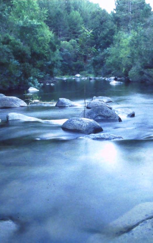
5 PROVIDING OPPORTUNITIES FOR LOW-IMPACT RECREATION Consistent with the primary objective of protecting water supply, recreational use of the Lower Cotter Catchment will remain low impact, with a matching level of facilities. The draft management plan identifies two management zones within the reserve and sets out which activities are permitted/not permitted within each zone. Existing restrictions on activities such as motor sport events, trail bike riding, camping, lighting fires and firewood collection will remain. Swimming is not permitted in the reserve and all recreational activities are prohibited in the reservoir. Fishing is only permitted in the Cotter River upstream of the junction with Condor Creek. Horse riding is permitted west of Brindabella Road. Driving (2WD and 4WD) and trail bike riding are only permitted on publicly accessible roads. Walking is permitted everywhere but cycling (including mountain bike riding) is permitted only on publicly accessible roads and management trails. Recreational activities in the reserve will continue to be monitored to ensure they do not adversely affect water quality or other catchment values. MANAGING FIRE Fire management in the Lower Cotter Catchment will aim to maximise compatibility between fire fuel management priorities and preferred water catchment and ecological outcomes. Cotter River at Vanitys Crossing


6 Cotter Dam with Blue Range hehind COMMUNITY INVOLVEMENT There is a strong recent history of community involvement in the reserve since the 2003 fire, with nearly 15,000 volunteers spending more than 47,000 hours planting over 306,000 trees and shrubs. The Lower Cotter Catchment Draft Reserve Management Plan encourages on-going community participation in stewardship of the catchment. Ongoing interpretation and education activities are proposed to improve community knowledge about the catchment s values and promote appropriate use. YOUR SAY The Environment, Planning and Sustainable Development Directorate welcomes written comments on the draft Reserve Management Plan for the Lower Cotter Catchment. Information is available at: YOU CAN MAKE WRITTEN COMMENTS BY:»» Visiting: ing: environment@act.gov.au»» Posting: Manager, Conservation Planning Environment, Planning and Sustainable Development Directorate PO Box 158, Canberra ACT 2601 Comments close: 10 March 2017 Community planting in the Lower Cotter Catchment
Lower Cotter Catchment Draft Reserve Management Plan 2017
 YOUR SAY The Environment, Planning and Sustainable Development Directorate welcomes comments on this draft Reserve Management Plan for the Lower Cotter Catchment. Information is available at: https://www.yoursay.act.gov.au/
The following recommendations will need to be re-evaluated given the recent fire at the Kennedy Meadows Pack Station.
 Kennedy Meadows Planning Unit The following recommendations will need to be re-evaluated given the recent fire at the Kennedy Meadows Pack Station. Sustainable Forestry Evaluate existing timber inventory
draft Environment Strategy
 draft Environment Strategy Our Commitment Our vision is to be the lifestream of Sydney for generations to come. We want to be world-class, delivering essential services that our customers love, in our
Sustainable Recreation
 Sustainable Recreation Sustainable Recreation An enjoyable way to be healthy, spiritual, and contribute to economic development while conserving resources for future generations. Sustainable Recreation
ANGLESEA FUTURES Land Use Scenarios Summary of Feedback - December 2017
 ANGLESEA FUTURES Land Use Scenarios - Summary of Feedback December 2017 ANGLESEA FUTURES Land Use Scenarios Summary of Feedback - December 2017 i Acknowledgements The Victorian Government s Department
OurFuture. Protecting. March Ontario Provincial Plans and Conservation Authorities
 Protecting OurFuture Ontario Provincial Plans and Conservation Authorities March 2015 Greenbelt Plan I Niagara Escarpment Plan I Growth Plan for the Greater Golden Horseshoe I Oak Ridges Moraine Conservation
Enlargement of the Cotter Reservoir and associated works
 Enlargement of the Cotter Reservoir and associated works Final public environment report 2008/4524 August 2009 Contents EXECUTIVE SUMMARY 1 1 INTRODUCTION 14 1.1 Overview 14 1.2 Context 16 1.3 Objectives
1. The impacts of development and settlement intensification on biodiversity and Aboriginal cultural heritage;
 Your reference Our reference: DOC13/40624 Contact: Liz Mazzer (02) 68835325 Date 8 th August 2013 General Manager Lithgow City Council PO Box 19 Lithgow NSW 2790 Attention: Ms Sherilyn Hanrahan, Strategic
SECTION 3: Water, Wetlands and Waterways
 SECTION 3: Water, Wetlands and Waterways KEY PRIORITY To ensure protection of water quality and quantity for use by residents, the commercial sector and ecosystems, through integrated consultation, planning,
DETAILED IMPACT ANALYSIS OF MARMOT BASIN LONG RANGE PLAN
 2.0 JURISDICTION Parks Canada s decisions about the acceptability of proposals presented in the LRP are guided by a number of regulatory instruments and policies, the most relevant of which are described
Environmental Trail Screening Tool. Legislation & Guidelines. Legislation/Guidelines. Implications for Trail Development
 This Legislation & Guidelines Matrix is a resource to accompany the developed by Recreation Sites and s BC. Legislation & Guidelines Legislation/Guidelines Assessment Act Applicability (Federal and Provincial)
ENLARGEMENT OF THE COTTER DAM AND ASSOCIATED WORKS DEVELOPMENT APPLICATION - IMPACT TRACK ASSESSMENT
 Rules/criteria C38 Trees C38 is not applicable to this proposal as The Tree Protection Act 2005 does not apply as the ECD site is located outside the urban area declared by the Minister under the Act;
Chapter 8 Natural Resources
 Chapter 8 Natural Resources 127-134 8.1 Introduction 8.2 Extractives Industry 8.3 Forestry 8.4 Fishing / Aquaculture 8.1 Introduction Kerry has a number of naturally occurring resources that contribute
STAFF REPORT WASHINGTON STATE PARKS AND RECREATION COMMISSION COVERED SHELTERS AND BIKE RACKS
 STAFF REPORT WASHINGTON STATE PARKS AND RECREATION COMMISSION COVERED SHELTERS AND BIKE RACKS TO: Douglas County Hearing Examiner FROM: Douglas County Land Services Staff RE: SP-2019-02 DATE: April 8,
MANZANITA LAKE PLANNING UNIT Willow Creek Watershed
 Existing Conditions & Uses Overview Area surrounding a small afterbay and creeks with ethnobotanical resources and valuable habitat 472 acres in Madera County; 337 acres outside the FERC boundary and 135
Fall River Mills Planning Unit. Fish, Plant, and Wildlife Habitat. LCP Volume II Supporting Analysis for Recommendations
 LCP Volume II Fall River Mills Planning Unit Fish, Plant, and Wildlife Habitat Conduct surveys of lands outside the FERC boundary to identify biological resources and enable their protection. It is likely
Kooragang Wetland Rehabilitation Project : 21 years of ecosystem repair and management in the Hunter River estuary Updated: 8/3/2016
 Kooragang Wetland Rehabilitation Project : 21 years of ecosystem repair and management in the Hunter River estuary Updated: 8/3/2016 Kooragang Wetland Rehabilitation Project (KWRP) was launched in 1993
Mt Buller & Mt Stirling Alpine Resort Management Board Draft Strategic Management Plan April 2013
 Mt Buller & Mt Stirling Alpine Resort Management Board Draft Strategic Management Plan 2013-2018 April 2013 Mt Buller & Mt Stirling Strategic Management Plan 1 2ABOUT THE STRATEGIC MANAGEMENT PLAN Context
The Toronto and Region Conservation Authority. request that the report be reviewed;
 GREENING OUR WATERSHEDS REVITALIZATION STRATEGIES FOR ETOBICOKE AND MIMICO CREEKS Including The Etobicoke-Mimico Report Card May, 2002 PREPARED BY THE ETOBICOKE AND MIMICO CREEK WATERSHEDS TASK FORCE November
South East Queensland. Report Card. hlw.org.au/reportcard
 South East Queensland Report Card 2017 hlw.org.au/reportcard A Snapshot of our Region 2017 Current trend of prolonged dry weather interrupted by severe rain events puts pressure on the landscape A total
Draft Wellington Park Drinking Water Catchment Management Strategy
 Draft Wellington Park Drinking Water Catchment Management Strategy Have Your Say This brochure provides a brief summary of the key issues and management actions of the Draft Wellington Park Drinking Water
(Draft) Addendum to 5-year Management Plan Mohican-Memorial State Forest
 Addendum to 5-year Management Plan Mohican-Memorial State Forest") (Draft) Addendum to 5-year Management Plan Mohican-Memorial State Forest Forest Description Mohican- Memorial State Forest (Mohican SF) is located in southern Ashland County, midway between Columbus and
(Draft) Addendum to 5-year Management Plan Mohican-Memorial State Forest Forest Description Mohican- Memorial State Forest (Mohican SF) is located in southern Ashland County, midway between Columbus and
Lake Britton Planning Unit. Fish, Plant, and Wildlife Habitat LAKE BRITTON PLANNING UNIT
 LAKE BRITTON PLANNING UNIT Pit-McCloud River Watershed Lake Britton Planning Unit Fish, Plant, and Wildlife Habitat Conduct surveys of lands outside the FERC boundary to identify biological resources and
File Code: 1900 Date: June 14, Dear Interested Parties,
 Logo Department Name Agency Organization Organization Address Information United States Forest National Forests in North Carolina 632 Manor Road Department of Service Appalachian Ranger District Mars Hill,
3.28 RESEARCH NATURAL AREAS
 3.28 RESEARCH NATURAL AREAS Introduction Research Natural Areas (RNAs) are areas designated, in perpetuity, for non-manipulative research and educational purposes, as well as to help maintain ecological
AVALONIA LAND CONSERVANCY FEE LAND STEWARDSHIP PRINCIPLES
 AVALONIA LAND CONSERVANCY FEE LAND STEWARDSHIP PRINCIPLES This document has been prepared for guidance in developing Property Management Plans for individual properties Avalonia owns in fee. It sets forth
Role Description Field Officer (Aboriginal)
") Role Description Field Officer (Aboriginal) Cluster Agency Planning and Environment Office of Environment and Heritage Division/Branch/Unit National Parks and Wildlife Service Location Various Classification/Grade/Band
Role Description Field Officer (Aboriginal) Cluster Agency Planning and Environment Office of Environment and Heritage Division/Branch/Unit National Parks and Wildlife Service Location Various Classification/Grade/Band
Management for the Next Phase of the
 THE PENRITH LAKES SCHEME Mine Rehabilitation hbl Works and Management for the Next Phase of the Penrith ihlakes Scheme Overview of Presentation Summary of the Penrith Lakes Scheme Key Elements of Scheme
Waterways Local Update
 Waterways Local Update 2015-16 Melbourne Water s work to improve waterways and provide flood protection in the City of Greater Dandenong. 300 m STABILISATION OF MILE CREEK 358 FLOOD INFORMATION REQUESTS
Gippsland Bushfire Management Planning
 Gippsland Bushfire Management Planning Background Victoria is one of the most bushfire prone areas in the world. Bushfire risk is increasing as our population grows and climate change results in more frequent,
Prepared by Christchurch City Council, P.O. Box 73013, Christchurch. Submission by Avon-Ōtākaro Network, 9 Stable Way, Christchurch 8051
 Christchurch City Council Christchurch October 2013 Submission to the Draft South New Brighton Reserves Management Plan, 2013 Draft South New Brighton Reserves Development Plan, 2013 For Bligh s Garden,
Clarks Fork of the Yellowstone Comprehensive River Management Plan
 Clarks Fork of the Yellowstone Comprehensive River Management Plan Background The Clarks Fork of the Yellowstone River is located on the Shoshone National Forest, approximately 30 miles north-northwest
KILARC RESERVOIR PLANNING UNIT Cow-Battle Creek Watershed
 Existing Conditions & Uses Overview Canal, small forebay, and powerhouse surrounded by private land in a rural setting 111 acres in Shasta County; 16 acres outside the FERC boundary and 95 acres inside
The Dalles Watershed Council
 The Dalles Watershed Council Fostering stewardship of Threemile Creek, Mill Creek and Chenowith Creek watersheds c/o Wasco County Soil and Water Conservation District 2325 River Road, Suite 3, The Dalles,
Outdoor and Environmental Studies GA 3: Written examination
 Outdoor and Environmental Studies GA 3: Written examination GENERAL COMMENTS This was the first examination of the new study design and generally students showed a good understanding of the course. Students
Ecologically Sustainable Fire Management for the Northern Rivers region of NSW
 Ecologically Sustainable Fire Management for the Northern Rivers region of NSW GREG BANKS 1, LYNN BAKER 2 & WAMINDA PARKER 1 1 Nature Conservation Council of NSW 2 Office of Environment and Heritage Corresponding
INTERIM MANAGEMENT PLAN. Silver Lake Woods
 INTERIM MANAGEMENT PLAN Silver Lake Woods August 6, 2016 INTERIM MANAGEMENT PLAN Silver Lake Woods August 6, 2016 Goal of the Management Plan. The Town of Georgia Conservation Commission has prepared this
Waterways Local Update
 Waterways Local Update 2015-16 Melbourne Water s work to improve waterways and provide flood protection in the City of Banyule. THREE ENVIRONMENTAL FLOWS TO YARRA RIVER PLATYPUS SURVEYS IN PLENTY AND TARAGO
RETURNING THE TIDE TO HEXHAM SWAMP
 Sixth International River Symposium Brisbane September 2003 RETURNING THE TIDE TO HEXHAM SWAMP Glenn Evans, Chief Executive Officer Hunter Catchment Management Trust 1 RETURNING THE TIDE TO HEXHAM SWAMP
Cotter dam one of a kind
 Sustainability in Public Works Conference 27-29 July 2014 Paper Cotter dam one of a kind K. Dickson, S. Wright * ACTEW Water, Canberra, ACT *Corresponding author. Email: sally.wright@actew.com.au
Blue Mountains Bushcare Network c/- 81 Prince Edward Street Blackheath NSW th June 2016
 Blue Mountains Bushcare Network c/- 81 Prince Edward Street Blackheath NSW 2785 26 th June 2016 Biodiversity Reforms - Have your say Office of Environment and Heritage PO Box A290 Sydney South NSW 1232
Project summaries: 2017 Environmental Research
 Project summaries: 2017 Environmental Research Organisation Project title Amount $ CSIRO Land and Water Flagship Compostable plastics in green wastes: the lowdown on their breakdown CSIRO Land and Water
Indiana Department of Natural Resources Division of Forestry 2017 SFI Forest Management Public Summary Audit Report
 Introduction Indiana Department of Natural Resources Division of Forestry 2017 SFI Forest Management Public Summary Audit Report The SFI program of Indiana Division of Forestry (DOF) has demonstrated conformance
Galiuro Exploration Drilling Project
 Galiuro Exploration Drilling Project Range and Noxious Weeds Report Prepared by: Gwen Dominguez Range Staff for: Safford Ranger District Coronado National Forest Date September 2, 2016 Forest Plan/Policy
CHAPTER 5 MANAGEMENT ZONES
 CHAPTER 5 MANAGEMENT ZONES The inventory and analysis that is outlined in Chapter 4 formed the basis for determining the management zones. The TRCA used this information to refine the definitions of the
FOREST SERVICE MANUAL NATIONAL HEADQUARTERS (WO) WASHINGTON, DC
 WASHINGTON, DC") Page 1 of 12 FOREST SERVICE MANUAL NATIONAL HEADQUARTERS (WO) WASHINGTON, DC CHAPTER VEGETATION ECOLOGY Amendment No.: 2000-2008-1 Effective Date: February 13, 2008 Duration: This amendment is effective
Page 1 of 12 FOREST SERVICE MANUAL NATIONAL HEADQUARTERS (WO) WASHINGTON, DC CHAPTER VEGETATION ECOLOGY Amendment No.: 2000-2008-1 Effective Date: February 13, 2008 Duration: This amendment is effective
Watershed Management in the Crooked River Basin:
 Watershed Management in the Crooked River Basin: The Western Juniper Story Max Nielsen-Pincus, Ph.D. Crooked River Watershed Council Watershed Restoration through Juniper Management Produced by The Juniper
TABLE OF CONTENTS. Introduction. Lower Platte South NRD Past and Present 1. Map of Lower Platte South NRD 2. Vision for the Future 3.
 TABLE OF CONTENTS Introduction ii Lower Platte South NRD Past and Present 1 Map of Lower Platte South NRD 2 Vision for the Future 3 Vision Table 5 i INTRODUCTION The Master Plan is the document that expresses
Role Description Field Officer (Aboriginal)
") Role Description Field Officer (Aboriginal) Cluster Planning and Environment Agency Office of Environment and Heritage Division/Branch/Unit National Parks and Wildlife Service Location Various Classification/Grade/Band
Role Description Field Officer (Aboriginal) Cluster Planning and Environment Agency Office of Environment and Heritage Division/Branch/Unit National Parks and Wildlife Service Location Various Classification/Grade/Band
Waterways Local Update
 Waterways Local Update 2016-17 Melbourne Water s work to improve waterways and provide flood protection in the City of Banyule. REDUCED THE RISK OF FLOODING 29.7 km WEED CONTROL ALONG WATERWAYS THREE ENVIRONMENTAL
5.2-2 Progress Report and Future Outlook
 5.2-2 Progress Report and Future Outlook Presentation to Peel Regional Council By Deborah Martin-Downs June 22, 2017 5.2-3 Outline 2016 Highlights and 2017 Accomplishments to Date Climate Risk Methodology
LIVING BASIN, LIVING MURRAY, LIVING COMMUNITIES
 LIVING BASIN, LIVING MURRAY, LIVING COMMUNITIES A partnership approach to care for the Murray-Darling Basin s natural resources Adrian Wells Murray Darling Association 2 March 2008 GTAV VCE Lecture - Melbourne
SOCIO-ECOLOGICAL RESEARCH TOPICS FOR THE BLUE MOUNTAINS
 SOCIO-ECOLOGICAL RESEARCH TOPICS FOR THE BLUE MOUNTAINS Stakeholder Forum to Identify Research Topics and Specific Questions and Issues of High Priority for Natural Resource Management Topics 1. Rural
Strategic Regional Priorities for the Hunter Joint Organisation Environment Division
 Strategic Regional Priorities for the Hunter Joint Organisation Environment Division Background Hunter Councils, and now the Hunter Joint Organisation of Councils has been delivering regional environmental
SASPoM Four Year Land Management Priorities
 SASPoM Four Year Land Management Priorities 2016-19 The Special Areas Strategic Plan of Management 2015 (SASPoM) requires Water NSW and the National Parks and Wildlife Service (NPWS) to develop a rolling
Waterways Local Update
 Waterways Local Update 2016-17 Melbourne Water s work to improve waterways and provide flood protection in the City of Moonee Valley. 7.9 km REVEGETATION ALONG WATERWAYS SUPPORTED WATER SENSITIVE URBAN
Programmatic Environmental Assessment Forest-Wide Erosion Abatement USDA Forest Service Shawnee National Forest
 Programmatic Environmental Assessment Forest-Wide Erosion Abatement USDA Forest Service Shawnee National Forest Alexander, Gallatin, Hardin, Jackson, Johnson, Massac, Pope, Saline, Union and Williamson
Update for Meaford Council on Grey Sauble Conservation Authority and its Programs. March 20, 2017
 Update for Meaford Council on Grey Sauble Conservation Authority and its Programs March 20, 2017 1 Purpose To update Meaford Council on the work of the Grey Sauble Conservation Authority (GSCA) This update
LOWER DRUM PLANNING UNIT Yuba-Bear River Watershed
 Existing Conditions & Uses Overview Provides open space and recreation opportunities within the Sierra Nevada foothills 1,098 acres in Placer and Nevada Counties 789 acres outside the FERC boundary; 309
Draft Northwest Territories Conservation Areas Action Plan Frequently Asked Questions
 Draft Northwest Territories Conservation Areas Action Plan 2015-2020 Frequently Asked Questions 1. What is the draft Northwest Territories (NWT) Conservation Areas Action Plan 2015-2020? The draft Conservation
Decision Notice Finding Of No Significant Impact
 Decision Notice Finding Of No Significant Impact U. S. Forest Service Southern Region Land Between The Lakes National Recreation Area Golden Pond, Kentucky Environmental Assessment for Prior Creek Project
Environment Levy Projects
 During the consultation process for the Wingecarribee 2031+ Community Strategic Plan, our community indicated its strong support for Council to continue, if not increase, the level of service that has
KINGS RIVER PLANNING UNIT Kings River Watershed
 Existing Conditions & Uses Overview Remote parcel in rugged canyon with adjoining whitewater rafting base camps 100 acres in Fresno County The Kings River Planning Unit is outside any FERC Project boundary
OUR AUSTRALIAN ALPS ARE CHANGING. FOR THE WORSE
 OUR AUSTRALIAN ALPS ARE CHANGING. FOR THE WORSE Graeme L. Worboys, David Freudenberger; Roger Good, Ian Pulsford and Sam Banks February 2015 OUR AUSTRALIAN ALPS ARE CHANGING. FOR THE WORSE This statement
The Irish Wildlife Trust submission to the National Peat Strategy
 The Irish Wildlife Trust submission to the National Peat Strategy The draft strategic plan is composed of a number of draft documents including a National Peatlands Strategy, a National Raised Bog SAC
The Sydney Metropolitan Catchment Management Authority leading the recovery of Sydney s biodiversity into the future
 The Sydney Metropolitan Catchment Management Authority leading the recovery of Sydney s biodiversity into the future Bob Junor SMCMA PO Box 3720 Parramatta NSW 2124. (This paper reflects the position as
STRATEGIC PLAN Jug Bay Wetlands Sanctuary STRATEGIC PLAN
 2015-2020 Jug Bay Wetlands Sanctuary STRATEGIC PLAN 0 JUG BAY WETLANDS SANCTUARY http://www.jugbay.org/ 1 INTRODUCTION Natural habitats at local, state, national and international levels are threatened
Managing Grassland Ecosystems: Student Worksheet
 Managing Grassland Ecosystems: Student Worksheet Elspeth Swan Managing grassland ecosystems Golden Sun Moth (Level 6) 2 Managing grassland ecosystems Prior to European settlement grasslands extended over
Management of our Woods
 Management of our Woods woodlandtrust.org.uk 1 The Woodland Trust Management of our woods The Woodland Trust owns over 1,000 sites across the UK, covering in excess of 23,000ha. This includes more than
Riparian Vegetation Protections. Heritage Tree Protection
 PLACER Protections in place: Oak Tree Retention/ Replacement Requirements General Plan Language Specific Voluntary Rural Design require preservation of native trees and groves through replacement and dedication
Don Catchment Vision
 Don Catchment Vision Don Catchment Vision A healthy and biodiverse catchment that is valued and enjoyed, contributing to the economic and social well-being of local communities. Aims for the Don To identify
Appendix General Environmental Risk Analysis
 Proposed Solar Power Station Near Moree, NSW (MOREE SOLAR FARM) Appendix Prepared by BP Solar & Walsh Consulting January 011 Background The body of the identifies all significant environmental risks identified
The Trouble with a Focus on Killing Rocky Mt Goats and Selling Hunting Tags MARY O BRIEN GRAND CANYON TRUST JULY 23, 2013
 The Trouble with a Focus on Killing Rocky Mt Goats and Selling Hunting Tags MARY O BRIEN GRAND CANYON TRUST JULY 23, 2013 Wrong animal Not native to Utah Digs up long-lived plants Eats mosses, lichens,
2017 Agricultural Water Quality Workshop
 2017 Agricultural Water Quality Workshop Focus Area Lower Lewis and Clark Clatsop SWCD has identified this area as one that needs much improvement This does not mean we can t do projects in other areas
FACTSHEET INTRODUCTION. help rebalance the water cycle, mitigate the effects of climate change and improve human health and livelihoods.
 1 FACTSHEET INTRODUCTION World Water Day, on 22 March every year, is about focusing attention on the importance of water. This year s theme, Nature for Water, explores nature-based solutions (NBS) to the
Watershed Health and Water Management in the Porcupine Hills
 Watershed Health and Water Management in the Porcupine Hills In Alberta, our quality of life is tied to healthy and sustainable water supplies for the environment, for our communities, and for our economic
WATERSHED. Report Card Nottawasaga Valley
 Nottawasaga Valley WATERSHED Report Card 2013 The Nottawasaga Valley Conservation Authority has prepared this report card as a summary on the state of our forests, wetlands, surface water, and ground water
Urban Riparian & Stream Restoration Program: Management & Photo Monitoring. Texas Water Resource Institute
 Urban Riparian & Stream Restoration Program: Management & Photo Monitoring Texas Water Resource Institute Hindrances to Healthy / Functional Riparian Areas: Farming too close to the bank Mowing, spraying
Memorandum of Administrative Arrangement. for the provision of. Community Service Obligations by ForestrySA
 Memorandum of Administrative Arrangement for the provision of Community Service Obligations by ForestrySA Annual Report 2012-13 ForestrySA / PIRSA June 2014 Page 1 of 16 FOREWORD Funding of ForestrySA
EIS Submission: Tom s Gully Underground Project
 EIS Submission: Tom s Gully Underground Project PO Box 40694 Casuarina NT 0811 Phone: 08 8945 6455 Fax: 08 8945 6055 Email: eo@afant.com.au www.afant.com.au Introduction The Amateur Fishermen s Association
South Australian Water Corporation HIGHLIGHTS
 South Australian Water Corporation HIGHLIGHTS 2015-16 CONTENTS CHIEF EXECUTIVE S MESSAGE 2 2015-16 HIGHLIGHTS 3 GREAT CUSTOMER EXPERIENCE 4 SAFE, CLEAN WATER 6 RELIABLE SERVICES 8 HEALTHY ENVIRONMENT 10
Prevention and Early Detection
 Prevention and Early Detection Prevention, early detection, and eradication of newly introduced invasive weed species is the most economical means of weed management. Prevention is best accomplished by
Assessing and Adapting to Climate Change Intermountain Region. Natalie Little Forest Service Ogden, Utah
 Assessing and Adapting to Climate Change Intermountain Region Natalie Little Forest Service Ogden, Utah We have lots of information! Adapting to climate change: USFS information & tools Climate Change
Atlasof Biodiversity
 Atlasof Biodiversity Second Edition Atlasof Biodiversity Second Edition First published in 1997, the Chicago Wilderness Atlas of Biodiversity provides an introduction to our region s natural treasures.
Highlights of South Platte Protection Plan
 Summer, 2001 Highlights of South Platte Protection Plan The South Platte Protection Plan has been developed by local communities and interested parties to protect and enhance natural and recreational values
Research Needs and Opportunities at Great Basin National Park
 Research Needs and Opportunities at Great Basin National Park Gretchen M. Baker Ecologist and Research Permit Coordinator Research Overview ~25-30 permits/year One-day to multi-year Researchers from all
Grandfather Restoration Project
 Grandfather Restoration Project a Collaborative Forest Landscape Restoration (CFLR) Program Presentation by Lisa Jennings Grandfather Restoration Project Coordinator lisanjennings@fs.fed.us August 12,
Statement of. Dale Bosworth, Chief U.S. Forest Service United States Department of Agriculture
 Statement of Dale Bosworth, Chief U.S. Forest Service United States Department of Agriculture Before the House Resource Committee Subcommittee on Forests and Forest Health U.S. House of Representatives
Land Use: Forests, Rangelands, Parks and Wilderness
 Land Use: Forests, Rangelands, Parks and Wilderness World Land Use Types of Protected Lands in U.S. Multiple-use lands National Forest (U.S.F.S.) sustainable yield multiple use used for logging, mining,
September 2016 ID Competency Statement Type
 September 06 Ensures that the impact assessment scope, criteria and conditions (geographic, environmental, economic, social, and cultural) are defined adequately. Develops a project management plan for
Fire Planning. Regional Fire Management Plan ACT GOVERNMENT
 ACT GOVERNMENT 2019-2028 Fire Planning Regional Fire Management Plan Environment Division Environment, Planning and Sustainable Development Directorate Overview Fire planning framework Background on fire
Research and discuss water catchments to help you answer the following questions.
 Catchments Clean water is vital to healthy communities, agriculture and economies. We need clean water upstream to have healthy communities downstream, and the health of rivers, lakes, bays, and coastal
Leaside to Main Infrastructure Refurbishment Project Strengthening the transmission system in your neighbourhood
 Leaside to Main Infrastructure Refurbishment Project Strengthening the transmission system in your neighbourhood Purpose of this Public Information Centre Provide you with an update on Hydro One s infrastructure
Regular Monthly Meeting of the Board of Directors
 Regular Monthly Meeting of the Board of Directors 5/24/18 APPLEGATE LIBRARY, 6:30 P.M. 4 th Thursday of the Month Agenda Call meeting to order, confirm quorum, financial statements, review agenda and notes.
Our Business Overview
 Our Business Overview Icon Water provides water and sewerage services to households, businesses and community organisations across the ACT and surrounding region. Many Canberra residents have family members
Preamble. List of contributors
 Preamble Providing water to the National Capital was a key consideration in determining the boundary of the Australian Capital Territory and the site for Canberra. The city was planned during the 1901
Terrestrial Ecology Services for the Murrumbidgee to Googong Water Transfer Project (M2G) Implementation of Compensatory Habitat Offset Package
 Implementation of Compensatory Habitat Offset Package") ABN 87 096 512 088 Simon Webber ACTEW Project Manager Murumbidgee to Googong Water Transfer Bulk Water Alliance GPO Box 366 Canberra City ACT 2601 www.ecoaus.com.au Terrestrial Ecology Services for the
ABN 87 096 512 088 Simon Webber ACTEW Project Manager Murumbidgee to Googong Water Transfer Bulk Water Alliance GPO Box 366 Canberra City ACT 2601 www.ecoaus.com.au Terrestrial Ecology Services for the
Overview and key environmental issues
 Blue Mountains Draft Local Environmental Plan 2013 1 Information Sheet 4 Overview and key environmental issues Use this document in conjunction with Information Sheet 5: SUBMISSION WRITING GUIDE AND SUMMARY
Managing Our Ecosystems
 Managing Our Ecosystems Managing Our Ecosystems Pranab Mukhopadhyay Goa University South Asian Network for Development and Environmental Economics Kathmandu, Nepal Session 12: ECONOMIC INSTRUMENTS FOR
BLUE MOUNTAINS SYSTEM. DAMS OF GREATER SYDNEY AND SURROUNDS Blue Mountains
 BLUE MOUNTAINS SYSTEM DAMS OF GREATER SYDNEY AND SURROUNDS Blue Mountains 1 Sydney s drinking water is collected from five catchment areas, occupying 16,000 square kilometres. Water is stored in 21 dams,