Application the SWAT model for Extreme Urban Flash Floods in Seoul
|
|
|
- Eugenia Ball
- 5 years ago
- Views:
Transcription
1 Application the SWAT model for Extreme Urban Flash Floods in Seoul 18 July 2013 International SWAT Conference, Toulouse, France Hyung Kyung Joh / Researcher / Weather Information Service Engine Division Sun Jung / Researcher / Weather Information Service Engine Division Jong-Sook Park / Senior Scientist / Weather Information Service Engine Division URL : wise2020.org
2 Contents Background & Aim Modeling Strategy Study Area Model Evaluation (Daily Time Step) Model Evaluation (Hourly Time Step) Summary & Conclusion Forward

 28 July 2011: 587 mm (7.")
: daily rainfall 171 mm (7.")
3 Natural Hazards in Seoul: Floods Seoul is km 2 with population of approximately 13 million 4 August 1998 Flood followed by floods in 2001, 2003, 2010, 2011 and 2012 However, No Information or Warnings from Government 4 August 1998 Flood: 384mm (8.2 midnight ~ pm) 28 July 2011: 587 mm (7.26 ~ 7.28) Rainfall distribution midnight ~ pm, 384mm Gangnam & Mt.Woomyun ( ): daily rainfall 171 mm (7.26), 301mm (7.27), 115 mm(7.28)


4 Weather Information Service Engine (WISE) Goal Better customized service Objective WISE Funded by KMA 8 Years (2012 ~ 2019) $100 million Strategy Micro scale observation, modeling and analysis Science Integration Information delivery Subjects Storm prediction system Boundary layer modeling Multi-scale modeling Joint Numerical Test-bed Observation Urban applications Agriculture applications Urban eco-systems Business applications WISE platform Information contents Graphic solution Technology transfer Design Plan 2013 Execute Step Execute Step Operation 2019


5 WISE & Applications Urban Flash Flood Response System User Focused Agri-meteorological System Road and Traffic Weather Information Service Urban Ecology Predicting & Forecasting System 1 st Phase: Build Micro-Scale Weather Observation Networks 2 nd Phase: Develop Models and Trial Services 3 rd Phase: Run WISE Platform WISE Platform Design Develop Services: UFF, UFAS, R-T WIS, UEP&FS Pilot Services of Applications Run WISE Platform Maintain WISE Platform WISE Platform WISE User Survey Design Architectu re of WISE Build WISE Platform Center Server Desktop Link to related institutes Mobile services Micro-Scale weather Observation Design Test-Bed Build Test-Bed Build Super-Site Contents & System Design Prototype Design Develop models Extend models Develop systems Integrate models and Systems


6 Study Aims Difficult to measure intensive rainfall, as it lasts short and exits over small areas and hard to estimate the inundation depth and other hydrological features on site of urban flash floods This study aims to provide a better understanding of urban flash flood with improving estimation of the amount of excess water and flood depth and to delineate flood vulnerable areas for Gangnam, one of the site of suffering from remarkable urban flash floods in Seoul.
 Implement Database Classifying Flash Floods Type Model (I) Surface")
 Daily run time step Spatial Data Regional Scale")
 Hydrological Data Daily Hourly 0.25 Hour run time step Floods with geological hazards: mud flow, land slides.")
7 Modeling Strategy A semi distributed model is built to evaluate sensitivity of intensive rainfall Multi-scale modelling is required to overcome limitations of ungauged catchment Catchment to Regional scale (2012 ~ 2015) Implement Database Classifying Flash Floods Type Model (I) Surface Runoff Model (II) Hydraulic Coupling Model (I) / (II) Weather Data Catchment Scale Floods: Flood plains.. Hydrological Surface-Runoff Model at catchment scale River channel flows Han River (1,150 km 2 ) Daily run time step Spatial Data Regional Scale Floods (up to 10 km 2 ) Delineating Urban/ungauged catchment & coupling with network analysis Drainage system & sewer network analysis Gangnam area (9 km 2 ) Hydrological Data Daily Hourly 0.25 Hour run time step Floods with geological hazards: mud flow, land slides.. Hydrological model combined with geological model Soil & Landslide analysis Mt. Woomyun


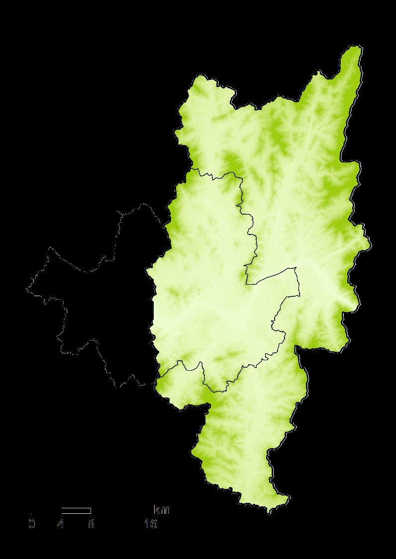
8 Study Area Outlet #1 Outlet #2 Seoul Han River Whole Outlet Outlet #3 Paldang - Dam Study Area Boundary Subbasin Ungauged Catchment Stream Water Level / Discharge Station Sewage Treatment Plant
9 Sites of Interest Outlet #1 Area Average Rainfall (Yearly) Average Discharge (Yearly) : km 2 : 1,573.2 mm : 3,037.3 m 3 Outlet #1 Outlet #2 Seoul Outlet #2 Area Average Rainfall (Yearly) Average Discharge (Yearly) Outlet #3 : km 2 : 1,564.6 mm : 3,262.0 m 3 Whole Outlet Outlet #3 Han River Paldang - Dam Area : km 2 Average Rainfall (Yearly) : 1,490.2 mm Average Discharge (Yearly) : 5,909.7 m 3

 Watershed Delineation, HRUs,")

10 Modeling Scheme Meteorological Data Precipitation, Temperature, Wind Speed, Solar Radiation, Relative Humidity GIS Data DEM, DSM Land Use, Soil type HEC-GeoRas Module Hydrological Modeling (SWAT) Watershed Delineation, HRUs, Point Sources, and so on Hydraulic Modeling (HEC-RAS) XSCuts, Friction Value, Boundary Condition Discharge Estimation Surface Flow Analysis

11 Spatial Input Data Spatial Resolution : 30 m


12 Performance Indicators Coefficient of Determination Root Mean Square Error Nash-Sutcliffe Model Efficiency Where, b x y O P N : : : : : : Estimated Regression Coefficient Variable Variable Observed Value Predicted Value Number of Data
13 Evaluation Results (I) Cal. 2010~2011 Daily Outlet #1 Val. 2008~2009 Paldang - Dam R 2 NS RMSE Cal Val

14 Evaluation Results (II) Cal. 2010~2011 Daily Outlet #2 Val. 2008~2009 Paldang - Dam R 2 NS RMSE Cal Val

15 Evaluation Results (III) Cal. 2010~2011 Daily Val. 2008~2009 Outlet #3 Paldang - Dam Cal. Val. R 2 NS RMSE
16 Evaluation Results (Whole) Cal. 2010~2011 Daily Val. 2008~2009 Whole Outlet Paldang - Dam R 2 NS RMSE Cal Val
17 Hourly Simulation ~ 8.5. Hourly Outlet #1 Outlet # ~ 8.5. Outlet # ~ 8.5. #1 #2 #3 R 2 NS RMSE


18 Small Ungauged Urban Catchment: Gangnam Heavy Urbanization Since Late 1960s Remained as Steep Slop Small Ungauged Urban Catchment Ineffectively Designed Urban Drainage / Sewer Systems Intensive Road Networks Accelerate Excess Water to Get Lower Lying Areas A B A B
 2.1 0.")
19 Surface Flow Analysis Flood Risk Map A B Subway Station Inundation Depth (m)
20 Summary & Conclusions This preliminary study is an on-going work as a part of the WISE (Weather Information Service Engine) project and purposes to forecast and prevent weather disaster, especially is focused on urban flash flood. The practice target of urban flash flood was occurred on July 26th This urban flash flood and flooding inundation at rainy season were simulated with coupling hydrologic (SWAT) and hydraulic (HEC- RAS) models. Undoubtedly, the simulated flooding inundation results were over / under estimated because of the lack of sewer network system analysis.

21 Forward Parameter Optimization for Urban Ungauged Catchment Uncertainty Analysis Sensitivity Analysis Sewer Network Analysis Predict Lag Time Delayed Under Various Range of Intensive Rainfalls (What If)


22 18 July 2013 Thank You for Listening Weather Information Service Engine Division, CATER Hyung Kyung Joh Sun Jung Jong-Sook Park / / / whgudrud@gmail.com alwayshappy.sun@gmail.com jspark9957@gmail.com
Modelling the impact of land use change on the water balance in the Xiangxi Catchment (Three Gorges Region, China) using SWAT
 using SWAT") Modelling the impact of land use change on the water balance in the Xiangxi Catchment (Three Gorges Region, China) using SWAT K. Bieger, B. Schmalz, Q. Cai, N. Fohrer 2010 International SWAT Conference
Modelling the impact of land use change on the water balance in the Xiangxi Catchment (Three Gorges Region, China) using SWAT K. Bieger, B. Schmalz, Q. Cai, N. Fohrer 2010 International SWAT Conference
Latest tools and methodologies for flood modeling
 Latest tools and methodologies for flood modeling Dr. Yuri Simonov Senior scientist, Hydrometcentre of Russia WMO Commission for Hydrology AWG member Floods - background Types of water-related natural
JOURNAL OF APPLIED SCIENCES RESEARCH
 Copyright 2015, American-Eurasian Network for Scientific Information publisher JOURNAL OF APPLIED SCIENCES RESEARCH ISSN: 1819-544X EISSN: 1816-157X JOURNAL home page: http://www.aensiweb.com/jasr Published
Study of Hydrology based on Climate Changes Simulation Using SWAT Model At Jatiluhur Reservoir Catchment Area
 Study of Hydrology based on Climate Changes Simulation Using SWAT Model At Jatiluhur Reservoir Catchment Area Budi Darmawan Supatmanto 1, Sri Malahayati Yusuf 2, Florentinus Heru Widodo 1, Tri Handoko
Institute of Water and Flood Management, BUET, Dhaka. *Corresponding Author, >
 ID: WRE 002 HYDROLOGICAL MODELING FOR THE SEMI UNGAUGED BRAHMAPUTRA RIVER BASIN USING SWAT MODEL S. Paul 1*, A.S. Islam 1, M. A. Hasan 1, G. M.T. Islam 1 & S. K. Bala 1 1 Institute of Water and Flood Management,
A comparison study of multi-gage and single-gage calibration of the SWAT model for runoff simulation in Qingjiang river basin
 A comparison study of multi-gage and single-gage calibration of the SWAT model for runoff simulation in Qingjiang river basin Dan YU, Xiaohua DONG, Lei LI, Sanhong SONG, Zhixiang LV and Ji LIU China Three
GIS Framework to Evaluate Impact of Climate Change on Water Resources
 GIS Framework to Evaluate Impact of Climate Change on Water Resources Dr. Nagraj S. Patil A. K. Gosain, Professor Civil Engineering Department I. I. T. Delhi Objectives of the Study To Develop portal to
Note that the Server provides ArcGIS9 applications with Spatial Analyst and 3D Analyst extensions and ArcHydro tools.
 Remote Software This document briefly presents the hydrological and hydraulic modeling software available on the University of Nice Server with Remote Desktop Connection. Note that the Server provides
RAINFALL-RUNOFF STUDY FOR SINGAPORE RIVER CATCHMENT
 10 th International Conference on Hydroinformatics HIC 2012, Hamburg, GERMANY RAINFALL-RUNOFF STUDY FOR SINGAPORE RIVER CATCHMENT CHI DUNG DOAN (1)(3), JIANDONG LIU (1), SHIE-YUI LIONG (1), ADRI VERWEY
2013 SWAT CONFERENCE Toulouse, France, July 17-19, 2013
 7/19/2013 2013 SWAT CONFERENCE Toulouse, France, July 17-19, 2013 Nguyen Kim Loi (1), Nguyen Duy Liem (1), Pham Cong Thien (1), Le Van Phan (1), Le Hoang Tu (1), Hoang Thi Thuy (1), Nguyen Van Trai (1),
Evaluating the Reduction Effect of Nonpoint Source Pollution Loads from Upland Crop Areas by Rice Straw Covering Using SWAT
 SESSION J2 : Water Resources Applications - I New Delhi, India 2012 International SWAT Conference Evaluating the Reduction Effect of Nonpoint Source Pollution Loads from Upland Crop Areas by Rice Straw
Estimation of Infiltration Parameter for Tehri Garhwal Catchment
 Estimation of Infiltration Parameter for Tehri Garhwal Catchment Ashish Bhatt 1 H L Yadav 2 Dilip Kumar 3 1 UG Student, Department of civil engineering, G B Pant Engineering College, Pauri, UK-246194 2,3
A Climate Change Impact Assessment of Urban Infrastructure by a Grid-Based Flood Model Focusing on Stream and Road Facilities
 A Climate Change Impact Assessment of Urban Infrastructure by a Grid-Based Flood Model Focusing on Stream and Road Facilities D. Lee, K. Oh, and B. Park Abstract Local governments in Korea are facing increasing
Application of a Basin Scale Hydrological Model for Characterizing flow and Drought Trend
 Application of a Basin Scale Hydrological Model for Characterizing flow and Drought Trend 20 July 2012 International SWAT conference, Delhi INDIA TIPAPORN HOMDEE 1 Ph.D candidate Prof. KOBKIAT PONGPUT
The Spatial Analysis between SWAT Simulated Soil Moisture, and MODIS LST and NDVI Products
 Konkuk University, Seoul, South Korea The Spatial Analysis between SWAT Simulated Soil Moisture, and MODIS LST and NDVI Products Geun Ae PARK Post-doctoral Researcher, Dept. of Civil and Environmental
2
 1 2 3 4 5 6 The program is designed for surface water hydrology simulation. It includes components for representing precipitation, evaporation, and snowmelt; the atmospheric conditions over a watershed.
1 THE USGS MODULAR MODELING SYSTEM MODEL OF THE UPPER COSUMNES RIVER
 1 THE USGS MODULAR MODELING SYSTEM MODEL OF THE UPPER COSUMNES RIVER 1.1 Introduction The Hydrologic Model of the Upper Cosumnes River Basin (HMCRB) under the USGS Modular Modeling System (MMS) uses a
Estimation of Actual Evapotranspiration at Regional Annual scale using SWAT
 Estimation of Actual Evapotranspiration at Regional Annual scale using SWAT Azizallah Izady Ph.D student of Water Resources Engineering Department of Water Engineering, Faculty of Agriculture, Ferdowsi
August 6, Min-Ji Park, Hyung-Jin Shin, Jong-Yoon Park Graduate Student. Geun-Ae Park. Seong-Joon Kim
 Comparison of Watershed Streamflow by Using the Projected MIROC3.2hires GCM Data and the Observed Weather Data for the Period of 2000-2009 under SWAT Simulation August 6, 2010 Min-Ji Park, Hyung-Jin Shin,
Application of the PRMS model in the Zhenjiangguan watershed in the Upper Minjiang River basin
 doi:10.5194/piahs-368-209-2015 Remote Sensing and GIS for Hydrology and Water Resources (IAHS Publ. 368, 2015) (Proceedings RSHS14 and ICGRHWE14, Guangzhou, China, August 2014). 209 Application of the
Climate Change in Europe s Cities
 in Europe s Cities Copernicus for Climate Adaptation and Mitigation Copernicus EU Copernicus EU Copernicus EU www.copernicus.eu WHY IS COPERNICUS NEEDED IN EUROPE S CITIES? Climate Copernicus Climate Service
Development of Flood Inundation Map for Bago River Basin
 Development of Flood Inundation Map for Bago River Basin Thet Hnin Aye - Student, Department of Civil Engineering, Yangon Technological University, Dr Win Win Zin - Supervisor, Department of Civil Engineering,
Training Course Brochure Building Capacity in Rural & Urban Water Management
 Training Course Brochure 2015 Building Capacity in Rural & Urban Water Management Introduction The WastePro Academy seeks to encourage the use of desktop software applications in the water and environmental
Hydrology and Hydraulic Modeling for Flash Floods Risk Assessment and Mapping
 Hydrology and Hydraulic Modeling for Flash Floods Risk Assessment and Mapping A Methodology Proposal Konstantinos Papatheodorou Eleni A. Tzanou Konstantinos Ntouros Flash Flood Assessment From Regional
APPLICATION OF SWAT MODEL TO THE STUDY AREA
 CHAPTER 5 APPLICATION OF SWAT MODEL TO THE STUDY 5.1 Introduction The Meenachil river basin suffers from water shortage during the six non-monsoon months of the year. The available land and water resources
Impacts of Rainfall Event Pattern and Land-Use Change on River Basin Hydrological Response: a Case in Malaysia
 International Proceedings of Chemical, Biological and Environmental Engineering, Vol. 93 (2016) DOI: 10.7763/IPCBEE. 2016. V93. 23 Impacts of Rainfall Event Pattern and Land-Use Change on River Basin Hydrological
Estimation of Hydrological Outputs using HEC-HMS and GIS
 Nigerian Journal of Environmental Sciences and Technology (NIJEST) www.nijest.com ISSN (Print): 2616-051X ISSN (electronic): 2616-0501 Vol 1, No. 2 July 2017, pp 390-402 Estimation of Hydrological Outputs
APPLICATION OF THE SWAT (SOIL AND WATER ASSESSMENT TOOL) MODEL IN THE RONNEA CATCHMENT OF SWEDEN
 MODEL IN THE RONNEA CATCHMENT OF SWEDEN") Global NEST Journal, Vol 7, No 3, pp 5-57, 5 Copyright 5 Global NEST Printed in Greece. All rights reserved APPLICATION OF THE SWAT (SOIL AND WATER ASSESSMENT TOOL) MODEL IN THE RONNEA CATCHMENT OF SWEDEN
Global NEST Journal, Vol 7, No 3, pp 5-57, 5 Copyright 5 Global NEST Printed in Greece. All rights reserved APPLICATION OF THE SWAT (SOIL AND WATER ASSESSMENT TOOL) MODEL IN THE RONNEA CATCHMENT OF SWEDEN
Event and Continuous Hydrological Modeling with HEC- HMS: A Review Study
 Event and Continuous Hydrological Modeling with HEC- HMS: A Review Study Sonu Duhan *, Mohit Kumar # * M.E (Water Resources Engineering) Civil Engineering Student, PEC University Of Technology, Chandigarh,
Delineation of Run of River Hydropower Potential of Karnali Basin- Nepal Using GIS and HEC-HMS
 Available online www.ejaet.com European Journal of Advances in Engineering and Technology, 2015, 2(1): 50-54 Research Article ISSN: 2394-658X Delineation of Run of River Hydropower Potential of Karnali
Vulnerability of Infrastructure due to Climate Change
 1 Vulnerability of Infrastructure due to Climate Change A Case Study of London, Ontario Elisabeth Bowering and Angela Peck M. E. Sc. Candidates Slobodan P. Simonovic, Professor The University of Western
Application of the SWAT Model to the Hii River Basin, Shimane Prefecture, Japan
 Application of the SWAT Model to the Hii River Basin, Shimane Prefecture, Japan H. Somura, I. Takeda, Y. Mori Shimane University D. Hoffman Blackland Research and Extension Center J. Arnold Grassland Soil
Parameter Calibration of SWAT Hydrology and Water Quality Focusing on Long-term Drought Periods
 2017 SWAT June 28-30, 2017 Centrum Wodne SGGW, Warsaw, Poland Theme I3 Environmental Applications Room: Assembly Hall 2 2017 International SWAT Conference Parameter Calibration of SWAT Hydrology and Water
Flood Inundation Mapping of Floodplain of the Jamuna River Using HEC-RAS and HEC-GeoRAS
 1 @2016 Journal of PU, Part: B Vol. 3 No:2, July 2016 pp 24-32 PRESIDENCY UNIVERSITY ISSN: 2224-7610 Flood Inundation Mapping of Floodplain of the Jamuna River Using HEC-RAS and HEC-GeoRAS ABSTRACT *M.
An integrated approach to select and characterize benchmark watersheds for sustainable resources management in Libya
 FIRST INTERNATIONAL SUSTAINABLE WATERSHED MANAGEMENT CONFERENCE (SuWaMa) 19-22 September 2011, Istanbul, Turkey An integrated approach to select and characterize benchmark watersheds for sustainable resources
FloodCast: A Framework for Enhanced Flood Event Decision Making for Transportation Resilience
 NCHRP 20-59(53) FloodCast: A Framework for Enhanced Flood Event Decision Making for Transportation Resilience April 2017 Presenters: Mat Mampara, Caroline Whitehead & Alaurah Moss (Dewberry) Project Overview
Analysis of Future Discharge in Nakdong River Basin According to Effect on Climate Change
 Hydrology Days 2012 Analysis of Future Discharge in Nakdong River Basin According to Effect on Climate Change Hyun Suk Shin 1, Mi Eun Kim 2, Ji Ye Im, and Tae Seok Shon 3 Department of Civil and Environmental
FLOOD Analysis And Development of Groundwater Recharge and Discharge Estimate Maps using GIS
 FLOOD Analysis And Development of Groundwater Recharge and Discharge Estimate Maps using GIS Dr. Ghulam Nabi Assistant Professor Center of Excellence in Water Resources Engineering, g University of Engineering
SAN BERNARD RIVER WATER QUALITY MODEL UPDATE. August 18, 2011
 SAN BERNARD RIVER WATER QUALITY MODEL UPDATE August 18, 2011 Agenda Model Set-up Watershed model Watershed delineations Generate model input files & establish coefficients Receiving Water model Establish
Simulation of Stream Flow Using Soil and Water Assessment Tool (SWAT) in Upper Ayeyarwady Basin
 in Upper Ayeyarwady Basin") Simulation of Stream Flow Using Soil and Water Assessment Tool (SWAT) in Upper Ayeyarwady Basin Su Wai Aung #1, and Nilar Aye *2 Abstract Stream flow is very important in water cycle and useful water resources
Simulation of Stream Flow Using Soil and Water Assessment Tool (SWAT) in Upper Ayeyarwady Basin Su Wai Aung #1, and Nilar Aye *2 Abstract Stream flow is very important in water cycle and useful water resources
Effects of climate change on streamflow in Kon Ha Thanh river watershed, Vietnam
 EPiC Series in Engineering Volume 3, 2018, Pages 2233 2240 Engineering HIC 2018. 13th International Conference on Hydroinformatics Effects of climate change on streamflow in Kon Ha Thanh river watershed,
Flood Inundation Mapping of Tadi River
 Flood Inundation Mapping of Tadi River CE 547 GIS in Water Resource Engineering Final Report Submitted By: Aayush Piya May 5, 2017 Contents 1 Motivation & Background... 3 2 Introduction... 3 3 Objective...
USING ARCSWAT TO EVALUATE EFFECTS OF LAND USE CHANGE ON WATER QUALITY. Adam Gold Geog 591
 USING ARCSWAT TO EVALUATE EFFECTS OF LAND USE CHANGE ON WATER QUALITY Adam Gold Geog 591 Introduction The Soil and Water Assessment Tool (SWAT) is a hydrologic transport model with an objective to predict
UNCERTAINTY ISSUES IN SWAT MODEL CALIBRATION AT CIRASEA WATERSHED, INDONESIA.
 UNCERTAINTY ISSUES IN SWAT MODEL CALIBRATION AT CIRASEA WATERSHED, INDONESIA. Sri Malahayati Yusuf 1 Kukuh Murtilaksono 2 1 PhD Student of Watershed Management Major, Bogor Agricultural University 2 Department
Integrating HEC HMS generated flow hydrographs with FLO-2D. Nanda Meduri, PE, PMP, CFM Seth Lawler Venkata Dinakar Nimmala, CFM
 Integrating HEC HMS generated flow hydrographs with FLO-2D Nanda Meduri, PE, PMP, CFM Seth Lawler Venkata Dinakar Nimmala, CFM Focus of this Presentation Introduction Methodology Challenges & Solutions
Flood Modelling For Peri Urban Areas in Adyar River
 Flood Modelling For Peri Urban Areas in Adyar River Saranya VP 1 Assistant Professor, Department of Civil Engineering, Bannari Amman Institute of Technology, Erode, India 1 ABSTRACT: Water is essential
International Journal of Scientific & Engineering Research, Volume 5, Issue 7, July-2014 ISSN Sruthy Nattuvetty Manoharan
 ISSN 2229-5518 210 Sruthy Nattuvetty Manoharan Department of Civil Engineering Government Engineering College, Thrissur Thrissur, 680009 sruthy.n.m@gmail.com a spatially distributed excess rainfall. It
Ensemble flood forecasting based on ensemble precipitation forecasts and distributed hydrological model Hongjun Bao
 The 32nd Conference on Hydrology The 98th AMS annual meeting Ensemble flood forecasting based on ensemble precipitation forecasts and distributed hydrological model Hongjun Bao PH.D, Professor, Senior
DATA AND ACTIVITIES NECESSARY FOR THE PREPARATION OF FLOOD HAZARD MAPS
 Abstract code: CP7 Development and implementation of a methodology of flood hazard mapping in Bulgaria, as required by Directive 2007/60 / EC S. Balabanova 1, V. Yordanova 1, V. Stoyanova 1 1 National
Estimating catchment sediment yield, reservoir sedimentation and reservoir effective life using SWAT Model
 Estimating catchment sediment yield, reservoir sedimentation and reservoir effective life using SWAT Model Sanjeet Kumar a *, Ashok Mishra a, N.S. Raghuwanshi a a Department of Agricultural and Food Engineering.
Assessment of StreamFlow Using SWAT Hydrological Model
 Assessment of StreamFlow Using SWAT Hydrological Model Sreelakshmi C.M. 1 Dr.K.Varija 2 1 M.Tech student, Applied Mechanics and Hydraulics, NITK, Surathkal,India 2 Associate Professor, Department of Applied
Flood Inundation Mapping of Floodplain of the Jamuna River Using HEC-RAS and HEC-GeoRAS. M. M. Rahman* 1, M. M. Ali 2
 Paper ID: WRE-42 14 International Conference on Recent Innovation in Civil Engineering for Sustainable Development () Department of Civil Engineering DUET - Gazipur, Bangladesh Flood Inundation Mapping
Flood forecasting model based on geographical information system
 192 Remote Sensing and GIS for Hydrology and Water Resources (IAHS Publ. 368, 2015) (Proceedings RSHS14 and ICGRHWE14, Guangzhou, China, August 2014). Flood forecasting model based on geographical information
BAEN 673 / February 18, 2016 Hydrologic Processes
 BAEN 673 / February 18, 2016 Hydrologic Processes Assignment: HW#7 Next class lecture in AEPM 104 Today s topics SWAT exercise #2 The SWAT model review paper Hydrologic processes The Hydrologic Processes
Assessment of Watershed Soundness by Water Balance Using SWAT Model for Han River Basin, South Korea
 2015 International SWAT Conference & Workshops October 12-16, 2015 Purdue University, USA SESSION A3: HYDROLOGY Room: Stewart 278 2015 International SWAT Conference Assessment of Watershed Soundness by
Anthropogenic and climate change contributions to uncertainties in hydrological modeling of sustainable water supply
 Anthropogenic and climate change contributions to uncertainties in hydrological modeling of sustainable water supply Roman Corobov The Republic of Moldova Several words about Moldova The Republic of Moldova
Introduction. Keywords: Oil Palm, hydrology, HEC-HMS, HEC-RAS. a * b*
 The Effect of Land Changes Towards in Sg. Pandan Perwira Bin Khusairi Rahman 1,a* and Kamarul Azlan bin Mohd Nasir 1,b 1 Faculty of Civil Engineering, Universiti Teknologi Malaysia, Malaysia a * wirakhusairirahman@gmail.com,
L. BOITHIAS, D. d A. BRESSIANI, S. SAUVAGE, K.C. ABBASPOUR, R. SRINIVASAN, W. LUDWIG, E. RICHARD, J.-M. SANCHEZ-PEREZ
 Application of the SWAT model to Mediterranean flash floods Does the use of fine climate stations grid and sub-basins delineation improve the modelling of river discharge and sediments fluxes at hourly
Flood forecasting model based on geographical information system
 doi:10.5194/piahs-368-192-2015 192 Remote Sensing and GIS for Hydrology and Water Resources (IAHS Publ. 368, 2015) (Proceedings RSHS14 and ICGRHWE14, Guangzhou, China, August 2014). Flood forecasting model
MULTI-LAYER MESH APPROXIMATION OF INTEGRATED HYDROLOGICAL MODELING FOR WATERSHEDS: THE CASE OF THE YASU RIVER BASIN
 MULTI-LAYER MESH APPROXIMATION OF INTEGRATED HYDROLOGICAL MODELING FOR WATERSHEDS: THE CASE OF THE YASU RIVER BASIN Toshiharu KOJIRI and Amin NAWAHDA 1 ABSTRACT A method for applying the multi-layer mesh
OBJECTIVES & ACTIVITIES OF KSNDMC
 OBJECTIVES & ACTIVITIES OF KSNDMC Disaster Management heavily depends on inputs from Science and Technology. KSNDMC has been serving as a common platform to the various response players in the field of
GIS Applications in Water Resources Engineering
 King Fahd University of Petroleum & Minerals City & Regional Planning Department Introduction to Geographic Information Systems Term Paper Presentation GIS Applications in Water Resources Engineering Prepared
Impact of Future Climate Change on the Water Resources System of Chungju Multi-purpose Dam in South Korea
 2012 International SWAT Conference Impact of Future Climate Change on the Water Resources System of Chungju Multi-purpose Dam in South Korea 19 July 2012 PARK, Jong-Yoon* / JUNG, In-Kyun / Jang, Cheol-Hee
Available online at ScienceDirect. Procedia Technology 24 (2016 )
") Available online at www.sciencedirect.com ScienceDirect Procedia Technology 24 (2016 ) 109 115 International Conference on Emerging Trends in Engineering, Science and Technology (ICETEST - 2015) Evaluation
Available online at www.sciencedirect.com ScienceDirect Procedia Technology 24 (2016 ) 109 115 International Conference on Emerging Trends in Engineering, Science and Technology (ICETEST - 2015) Evaluation
Efficiency of non-structural flood mitigation measures: room for the river and retaining water in the landscape. The proposal
 Efficiency of non-structural flood mitigation measures: room for the river and retaining water in the landscape The proposal By: Félix Francés, Günter Blöschl and Axel Bronstert The Consortium Technical
HYDROLOGICAL INVESTIGATIONS AND ANALYSIS FOR HYDROPOWER PROJECTS
 HYDROLOGICAL INVESTIGATIONS AND ANALYSIS FOR HYDROPOWER PROJECTS Ph.D. THESIS by ILA DASHORA ALTERNATE HYDRO ENERGY CENTRE INDIAN INSTITUTE OF TECHNOLOGY ROORKEE ROORKEE 247 667 (INDIA) DECEMBER, 2015
Creating a Flood Forecasting System for the San Diego River Watershed
 Creating a Flood Forecasting System for the San Diego River Watershed Rand Allan County of San Diego Flood Control Martin J. Teal, P.E., P.H., D.WRE WEST Consultants inc. OUTLINE San Diego River Watershed
Radar-based flood forecasting: Quantifying hydrologic prediction uncertainty
 Severe Storms Prediction and Global Climate Impact on the Gulf Coast, Rice University, October 29 31, 2008 Radar-based flood forecasting: Quantifying hydrologic prediction uncertainty Baxter E. Vieux,
Water Resources Status in Danube River Basin. SWAT Conference_ Spain, Toledo June 2011
 Water Resources Status in Danube River Basin SWAT Conference_ Spain, Toledo June 2011 Objectives Objectives Building and calibratîng a hydrologic model of Danube Basin Using SWAT and SWAT CUP Quantifying
The Fourth Assessment of the Intergovernmental
 Hydrologic Characterization of the Koshi Basin and the Impact of Climate Change Luna Bharati, Pabitra Gurung and Priyantha Jayakody Luna Bharati Pabitra Gurung Priyantha Jayakody Abstract: Assessment of
Assessment of land-use change on streamflow using GIS, remote sensing and a physically-based model, SWAT
 doi:10.5194/piahs-364-38-2014 38 Evolving Water Resources Systems: Understanding, Predicting and Managing Water Society Interactions Proceedings of ICWRS2014, Bologna, Italy, June 2014 (IAHS Publ. 364,
The Drainage Basin System
 The Drainage Basin System These icons indicate that teacher s notes or useful web addresses are available in the Notes Page. This icon indicates that the slide contains activities created in Flash. These
Kangwon National University
 2011. 6. 16 Kangwon National University Ⅰ Introduction Ⅱ Ⅰ Methodologies Ⅲ Ⅰ Results Ⅳ Ⅰ Conclusions Ⅰ Introduction Using SWAT 1. Control the rising water temperature 2. Provide habitat for animal 3. Control
Suspended Sediment Discharges in Streams
 US Army Corps of Engineers Hydrologic Engineering Center Suspended Sediment Discharges in Streams April 1969 Approved for Public Release. Distribution Unlimited. TP-19 REPORT DOCUMENTATION PAGE Form Approved
Hydrological And Water Quality Modeling For Alternative Scenarios In A Semi-arid Catchment
 Hydrological And Water Quality Modeling For Alternative Scenarios In A Semi-arid Catchment AZIZ ABOUABDILLAH, ANTONIO LO PORTO METIER Final Conference: Brussels, Belgium-4-6 November 2009 Outline Problem
HYDROLOGICAL MODELING OF AN AGRICULTURAL WATERSHED USING HEC-HMS HYDROLOGICAL MODEL, REMOTE SENSING AND GEOGRAPHICAL INFORMATION SYSTEM
 HYDROLOGICAL MODELING OF AN AGRICULTURAL WATERSHED USING HEC-HMS HYDROLOGICAL MODEL, REMOTE SENSING AND GEOGRAPHICAL INFORMATION SYSTEM Niravkumar K. Pampaniya 1, Mukesh K. Tiwari 2, M. L. Gaur 3 1 M.Tech.
Parameter Estimation of a Conceptual Rainfall Runoff Model and Application to Mediterranean Catchments
 Parameter Estimation of a Conceptual Rainfall Runoff Model and Application to Mediterranean Catchments A. Hreiche a, C. Bocquillon a, W. Najem a a CREEN, Ecole Supérieure d Ingénieurs de Beyrouth, Université
Simulation of Daily Streamflow
 US Army Corps of Engineers Hydrologic Engineering Center Simulation of Daily Streamflow April 1968 Approved for Public Release. Distribution Unlimited. TP-6 REPORT DOCUMENTATION PAGE Form Approved OMB
Chapter 1 Introduction
 Engineering Hydrology Chapter 1 Introduction 2016-2017 Hydrologic Cycle Hydrologic Cycle Processes Processes Precipitation Atmospheric water Evaporation Infiltration Surface Runoff Land Surface Soil water
Hydrology and Water Resources Engineering
 Hydrology and Water Resources Engineering SUB GSttingen 214 868 613 K.C. Patra 't'v Mai Narosa Publishing House New Delhi Chennai Mumbai Calcutta CONTENTS Preface vii 1. Introduction 1 1.1 General 1 1.2
Evaluation of Swat for Modelling the Water Balance and Water Yield in Yerrakalva River Basin, A.P. National Institute of Hydrology, Roorkee
 Evaluation of Swat for Modelling the Water Balance and Water Yield in Yerrakalva River Basin, A.P. By Dr. J.V. Tyagi Dr. Y.R.S. Rao National Institute of Hydrology, Roorkee INTRODUCTION Knowledge of water
Managing Extreme Floods in Pakistan
 Managing Extreme Floods in Pakistan Shahbaz Khan Chief, Water and Sustainable Development UNESCO Division of Water Sciences 2 Monsoon 2010 : Extreme Rainfall - Flood INTERACTION L Monsoon 2010 (July) Interaction
2017 International SWAT Conference, Warsaw, Poland
 2017 International SWAT Conference, Warsaw, Poland Evaluation of Groundwater Use Impact on the Drying Stream by Modifying SWAT Groundwater Balance Equation 2017. 6. 30 Jung, Chung-Gil (wjd0823@konkuk.ac.kr)
NAP-GSP REGIONAL TRAINING WORKSHOP FOR ASIA Mainstreaming Climate Change Adaptation into Water Resources Seoul, September 2017
 NAP-GSP REGIONAL TRAINING WORKSHOP FOR ASIA Mainstreaming Climate Change Adaptation into Water Resources Seoul, 13-16 September 2017 Session 2 Climate and hydrological Information and Services Hydrological
Upstream structural management measures for an urban area flooding in Turkey
 doi:10.5194/piahs-370-45-2015 Author(s) 2015. CC Attribution 3.0 License. Upstream structural management measures for an urban area flooding in Turkey Z. Akyurek 1, B. Bozoğlu 1, S. Sürer 2, and H. Mumcu
Prairie Hydrological Model Study Progress Report, April 2008
 Prairie Hydrological Model Study Progress Report, April 2008 Centre for Hydrology Report No. 3. J. Pomeroy, C. Westbrook, X. Fang, A. Minke, X. Guo, Centre for Hydrology University of Saskatchewan 117
TECHNICAL NOTE: ESTIMATION OF FRESH WATER INFLOW TO BAYS FROM GAGED AND UNGAGED WATERSHEDS. T. Lee, R. Srinivasan, J. Moon, N.
 TECHNICAL NOTE: ESTIMATION OF FRESH WATER INFLOW TO BAYS FROM GAGED AND UNGAGED WATERSHEDS T. Lee, R. Srinivasan, J. Moon, N. Omani ABSTRACT. The long term estimation of fresh water inflow to coastal bays
Participatory risk assessment and monitoring
 Integrated Local Risk Management Participatory risk assessment and monitoring (Draft 19.06.09) Guidelines for baseline assessment and monitoring 1 Strengths and limits of ILRM and its participatory risk
Models Overview: Purposes and Limitations
 Models Overview: Purposes and Limitations Pollutant load originates from: Point-source discharges (NPDES facilities) Info is available on the discharges (DMRs, etc.) Some are steady-flow, others are precip-driven
The Effect Of Flood Reduction And Water Conservation Of Decentralized Rainwater Management System
 City University of New York (CUNY) CUNY Academic Works International Conference on Hydroinformatics 8-1-2014 The Effect Of Flood Reduction And Water Conservation Of Decentralized Rainwater Management System
Hydrologic Engineering Center. Training Course on. Hydrologic Modeling with HEC-HMS. Davis, CA. Course Description
 Hydrologic Engineering Center Training Course on Hydrologic Modeling with HEC-HMS Davis, CA Course Description The course provides an introduction to HEC-HMS for new users, focusing both on using the program
Flash Flood Forecasting. WORLD METEOROLOGICAL ORGANIZATION COMMISSION FOR BASIC SYSTEMS SWFDP Steering group meeting Feb 2012
 Flash Flood Forecasting Contents 1. Background 2. Challenges 3. Opportunities 4. Way Forward 1. Background; Angola Burundi Congo Ethiopia Kenya Rwanda Tanzania Uganda River Flood 1 1 2 3 2 Flash floods
Dynamic Inundation Mapping for Emergency Planning and Disaster Response
 Dynamic Inundation Mapping for Emergency Planning and Disaster Response Ross Gordon, LEED AP October 29, 2008 Presentation Overview Introduce MIKE FLOOD Rice / TMC Case Study Emergency Planning Disaster
Evaluation of drought impact on groundwater recharge rate using SWAT and Hydrus models on an agricultural island in western Japan
 doi:10.5194/piahs-371-143-2015 Author(s) 2015. CC Attribution 3.0 License. Evaluation of drought impact on groundwater recharge rate using SWAT and Hydrus models on an agricultural island in western Japan
Countermeasures against urban flood in Beijing. Urban flood inundation warning and flood hazard mapping in China
 Countermeasures against urban flood in Beijing Fen Yang Beijing Institute of Water (BIW), China Urban flood inundation warning and flood hazard mapping in China Wang Jing China Institute of Water Resources
Hydrologic Engineering Center. Training Course on. Hydrologic Modeling with HEC-HMS April 2018 Davis, CA. Course Description
 Hydrologic Engineering Center Training Course on Hydrologic Modeling with HEC-HMS 23-27 April 2018 Davis, CA Course Description The course provides an introduction to HEC-HMS for new users, focusing both
A Hydrologic Study of the. Ryerson Creek Watershed
 A Hydrologic Study of the Ryerson Creek Watershed Dave Fongers Hydrologic Studies Unit Land and Water Management Division Michigan Department of Environmental Quality May 8, 2002 Table of Contents Summary...2
RAINFALL RUNOFF MODELLING AND INUNDATION ANALYSIS OF BAGMATI RIVER AT TERAI REGION OF NEPAL
 RAINFALL RUNOFF MODELLING AND INUNDATION ANALYSIS OF BAGMATI RIVER AT TERAI REGION OF NEPAL Baral MITRA Supervisor: Prof. A.W. Jayawardena** MEE07179 ABSTRACT Climatic variability, unplanned land use pattern
Module 2 Measurement and Processing of Hydrologic Data
 Module 2 Measurement and Processing of Hydrologic Data 2.1 Introduction 2.1.1 Methods of Collection of Hydrologic Data 2.2 Classification of Hydrologic Data 2.2.1 Time-Oriented Data 2.2.2 Space-Oriented
Department of Applied Geomatics Nong Lam University, Ho Chi Minh City (2) University of Technical Education Ho Chi Minh City (3)
 University of Technical Education Ho Chi Minh City (3)") TRF-DSS CONFERENCE: DSS AS A COLLABORATIVE PLATFORM TOWARDS VIC FOR COLLECTIVE MANAGEMENT OF AGRICULTURAL AND NATURAL RESOURCES Nakhon Phanom, Thailand, September 10-11, 2013 Nguyen Kim Loi (1), Nguyen
TRF-DSS CONFERENCE: DSS AS A COLLABORATIVE PLATFORM TOWARDS VIC FOR COLLECTIVE MANAGEMENT OF AGRICULTURAL AND NATURAL RESOURCES Nakhon Phanom, Thailand, September 10-11, 2013 Nguyen Kim Loi (1), Nguyen