KANKAKEE COUNTY PLANNING DEPARTMENT APPLICATION FOR CLASS I & II GRADING AND DRAINAGE/STOMRWATER PERMIT APPLICATION
|
|
|
- Rhoda Morrison
- 5 years ago
- Views:
Transcription
 937-2940 Fax (815) 937-2974 http://planning.k3county.")

1 KANKAKEE COUNTY PLANNING DEPARTMENT APPLICATION FOR CLASS I & II GRADING AND DRAINAGE/STOMRWATER PERMIT APPLICATION Michael J. Van Mill, AICP Planning Director 189 East Court Street Kankakee, IL Telephone (815) Fax (815) OVERVIEW In April 2006 the Kankakee County Board adopted the Kankakee County Stormwater Management Ordinance. The Ordinance requires that applicable projects in the unincorporated areas of Kankakee County obtain either a Class I or Class II Grading and Drainage Stormwater Permit. Listed below are just a few of the many purposes and benefits of this program, for additional information you may consult Section of the County Code: Comply with the National Pollutant Discharge Elimination System. Ensures the protection and conservation of our natural resources. Promotes and protects the public health, safety and general welfare of the citizens from the hazards of flooding. Assures that new developments/redevelopments do not increase flood or drainage hazards to others or create unstable conditions susceptible to erosion. Protects the quantity/quality of wetlands. Lessens the taxpayer s burden for flood related disasters, repairs to flood damaged public facilities and utilities, and flood rescue/relief operations. An explanation of both Class I and Class II are listed below, this will assist with determining which permit your project requires. A flowchart is also attached to the application to further aid with defining classification, see Attachment A. Class I: All construction except single family residential and duplexes that meets one of the following thresholds shall require a Class I grading and drainage permit: Any construction that will require a variance to an existing rule or regulation regarding coverage or impervious surface including the addition of an impervious surface area (i.e. streets, roof, patio or parking area or any combination thereof) greater than 500 square feet and less than 10,000 square feet requires a Class I grading and drainage permit. Any land disturbing activity on the sloping side of the slope disturbance line, but does not otherwise require a Class II grading and drainage permit.
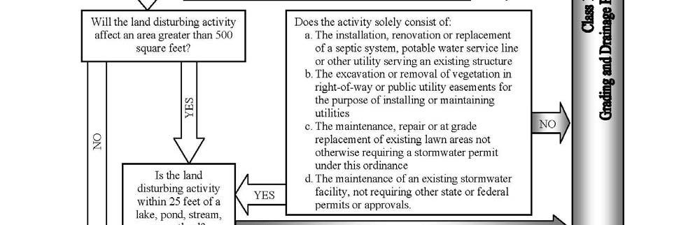
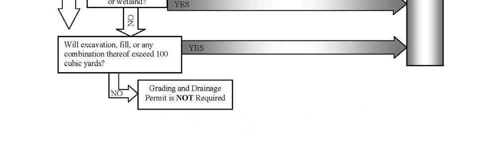
2 Construction of one or more single family dwellings or duplexes that is/are constructed as part of a subdivision development or on an individual parcel without an approved neighborhood drainage plan or stormwater pollution prevention plan. Any land disturbing activity (i.e. clearing, grading, stripping, excavation, fill or any combination thereof) that will affect an area in excess of 5,000 square feet, unless the activity solely consists of: The installation, renovation or replacement of a septic system, potable water service line or other utility serving an existing structure. The excavation or removal of vegetation in right of way or public utility easements for the purpose of installing and maintaining utilities. The maintenance, repair or at grade replacement or existing lawn areas not otherwise requiring a stormwater permit under the Ordinance. The maintenance or an existing stormwater facility, not requiring other state or federal permits or approvals. Any land disturbing activity that will affect an area in excess of 500 square feet if the activity is within 25 feet of a lake, pond, stream or a wetland. Excavation, fill or any combination thereof that will exceed 100 cubic yards. Class II: Any construction that meets one of the following thresholds shall require a Class II grading and drainage permit: Any construction that will include the addition of an impervious surface area (i.e. streets, roof, patio or parking area or any combination thereof) greater than 10,000 square feet. Any land disturbing activity (i.e. clearing, grading, stripping, excavation, fill or any combination thereof) that will affect an area greater than one acre (43,560 square feet).
3 EcoCAT: All Class II Grading and Drainage/Stormwater applications (Class I, as deemed necessary by Staff) are now required to submit an Illinois Department of Natural Resources Ecological Compliance Assessment Tool (EcoCAT) results report at the time of filing the application. This must be completed to comply with the Illinois Endangered Species Protection Act [520 ILCS 10/11(b)] and the Illinois Natural Areas Preservation Act [525 ILCS 30/17]. These laws requires state agencies and units of local governments to consider the potential adverse effects of proposed action on the Illinois endangered and threatened species and sites list on the Illinois Natural Areas Inventory. EcoCAT provides a report to determine if your proposed action(s) is in the vicinity of any protected natural resources. In 2006, IDNR implemented EcoCAT, an internet based system designed to facilitate the consultation process. EcoCAT uses, databases, Geographic Information System mapping and a set of programmed decision rules to determine if you proposed action(s) may be in the vicinity of protected natural resources. You may find additional information about the process and how to request an EcoCAT report in Attachment B of this application.
4 APPLICANT INFORMATION All applicants are required to complete the following: Owner name(s): Address: City: State: Zip code: Telephone & Fax number(s): (s): Developer name(s): Address: City: State: Zip code: Telephone & Fax number(s): (s): Contractor name(s): Address: City: State: Zip code: Telephone & Fax number(s): (s): Engineering firm: Engineer contact: Engineer s address: City: State: Zip code: Engineer s telephone & fax number(s): Engineer s (s):
5 Indicate primary contact person Owner Developer Contractor Engineer (Signature of owner or authorized agent) (Date) SUBJECT PROPERTY INFORMATION 911 address: General location: Township: PIN (parcel index number): Description of proposed construction: SUPPLEMENTARY INFORMATION Certification that all construction covered by the grading and drainage permit will be undertaken in accordance with the plans approved. Yes No Plans dated: Application fee of $ received as set forth in Chapter 18 of the County Code. (Ord. No ) Yes No CLASS I ONLY (complete only if applicable) Erosion control site plan received that was created with the use a worksheet available from the Kankakee County Soil and Water Conservation District showing the amount of impervious area being created and BMP s (Best Management Practices) to be implemented. Yes No
6 CLASS II ONLY (complete only if applicable) A faithful performance bond(s), letter of credit or other improvement security to cover all costs of improvements, landscaping, maintenance of improvements/landscaping, soil erosion and sediment control measures for such period as specified by the jurisdiction and engineering and inspection costs to cover the cost of failure or repair of improvements installed on the site. (The amount must be deemed sufficient by the Planning Director or his/her designee). Yes No The following information shall be submitted for both existing and proposed property conditions for all applicable developments: A topographic survey of the property at one-foot contours (or one-half foot contours for relatively flat areas where additional detail will be required to review drainage designs) unless otherwise specified or approved by the Planning Director or his designee to a consistent vertical datum specified by the County; and an existing drainage and proposed drainage plan for the property and 100 feet surrounding the property at a scale of not more than 100 feet to one inch, and including the following (unless otherwise specified by the Planning Director or his designee): Property boundary, dimensions and approximate acreage. Building setback lines. All existing and proposed structures and sizes. Square feet of existing and proposed impervious surface. All existing or proposed easements. All existing, observed or proposed water or monitoring well head locations. All existing, observed or proposed watermains. All sanitary or combined sewer lines and septic systems. The banks and centerline of streams and channels. Shoreline of lakes, ponds and detention basins with normal water level elevation. Location, size and slope of stormwater conduits and drainage swales. Detention facilities showing inlet and outlet locations and details. Roads, streets and associated stormwater inlets including finished grades. Base flood elevation, flood fringe and regulatory floodway. A vicinity map showing the relationship of the site to its general surroundings at a scale of not greater than 2,000 feet to one inch (1:24,000). Title, scale, north arrow, legend, seal of licensed professional engineer, date and name of person preparing plans. Subwatershed boundaries within the property. Offsite areas draining to property, including entire offsite drainage boundary(ies). Depressional storage areas, including nonjurisdictional wetlands. Inventoried farm drains and tiles. Soil classifications.
7 The following certifications and design statements shall be provided: Basis of design for the final drainage system components. A statement giving any applicable engineering assumptions and calculations. Design calculations and other submittals as required by this article, including flow rates and velocities at critical points in the drainage system. A statement of certification of all drainage plans, calculations and supporting data by a professional engineer licensed in the state. A depiction of environmental features of the property and immediate vicinity including the following: The limits of wetland areas. The location of trees greater than eight inches in diameter, taken at 4.5 feet dbh in areas to be disturbed. Any designed natural areas or prime farmland so designated by the federal, state or county government. Any proposed environmental mitigation measures. Location and dimensions of a stream buffer area (if required by local jurisdiction). Base flood elevation, flood fringe and regulatory floodplains. Observed abandoned mines. Any and all local, state or federal maps delineating floodplains, floodways, or 100 year frequency flood elevation shall be annotated to reflect the proposed change. Conditional approval by FEMA or other regulatory agencies of the proposed changes in the FIRM map. Engineering calculations and data supporting all proposed plans. Hydrologic analysis shall be completed in accordance with division 12, subdivision II (Hydrologic design criteria) of the Ordinance. Detention system shall be completed in accordance with division 12, subdivision III (Design system design criteria) of the Ordinance. If the project involves modification of a channel with an upstream watershed exceeding 200 acres, the following information shall be submitted: A discussion of the purpose and need for the proposed work. Discussion of the practicability of using alternative locations or methods to accomplish the purpose of the proposed work. Analysis of the impacts of the proposed project, considering cumulative effects on flood storage and the physical and biological conditions of the body of water effected. Hydraulic analysis of the channel modifications, including pre and post project base flood elevations. Additional information as required by the Ordinance. Stormwater pollution prevention plan prepared in accordance with division 13 of the Ordinance.
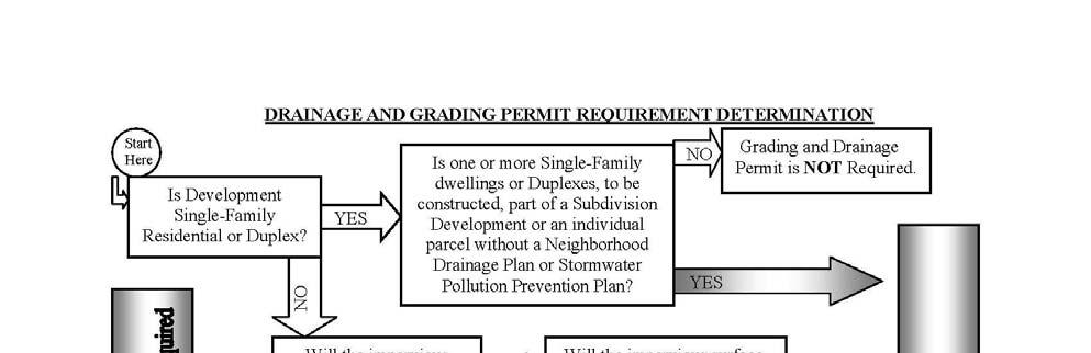

8 \\ ATTACHMENT A FLOWCHART
 are now required to submit an Illinois Department of Natural Resources Ecological Compliance")
9 ATTACHMENT B EcoCAT WHAT? All Class II Grading and Drainage/Stormwater applications (Class I, as deemed necessary by Staff) are now required to submit an Illinois Department of Natural Resources Ecological Compliance Assessment Tool (EcoCAT) results report at the time of filing the request. WHY? This must be completed to comply with the Illinois Endangered Species Protection Act [520 ILCS 10/11 (b)] and the Illinois Natural Preservation Act [525 ILCS 30/17]. These laws require state agencies and units of local governments to consider the potential adverse effects of proposed actions on the Illinois endangered species and sites listed on the Illinois Natural Areas Inventory. HOW EcoCAT WORKS: EcoCAT, will provide a report to determine if your proposed action is in the vicinity of any protected natural resources. In 2006, IDNR implemented EcoCAT, an internet based system designed to facilitate the consultation process. EcoCAT uses databases, Geographical Information System mapping, and a set of programmed decision rules to determine if you proposed action may be in the vicinity of protected natural resources. EcoCAT asks a series of General Information questions that you must answer to ensure that your project receives the appropriate review and is assigned to the correct staff member. After completion of the inquiry you will receive a printer-friendly EcoCAT Results Report that either: Terminate consultation if no resources are in the vicinity; or Lists resources in the vicinity and indentifies the staff member who will review the action. After review, staff will either: Terminate consultation because adverse effects are unlikely; Request additional information, or Recommend methods to minimize potential adverse effects. The report is then utilized by decision makers in assisting with the evaluation of the proposed project/request. HOW TO OBTAIN AN EcoCAT REPORT: The report is offered through the Illinois Department of Natural Resources. You may request an EcoCAT report or find additional information about the process at the Illinois Department of Natural Resources website at
10 FOR PLANNING DEPARTMENT USE ONLY (please do not detach) Date Staff Receipt of application Application reviewed by Sent to review engineer Approval of application Denial of application * Permit Number: Approval of application * If denied state reason:
Will County Site Development Permit Submittal Checklist TAB 1 PROJECT OVERVIEW
 Applicant: Reviewer: Permit No.: The following tables contain a checklist of the requirements before a review for a Site Development Permit submittal will be accepted. Not all requirements pertain to every
Ordinance No Lot Surface Drainage
 Ordinance No. 35-2008 - Lot Surface Drainage The Township has adopted a new Lot Surface Drainage Ordinance which amends Chapter 170, Article IX, Subdivision and Site Plan Review by adding a new Section
Stormwater Erosion Control & Post-Construction Plans (Stormwater Quality Plans)
") Stormwater Erosion Control & Post-Construction Plans (Stormwater Quality Plans) Allen County Stormwater Plan Submittal Checklist The following items must be provided when applying for an Allen County Stormwater
Stormwater Erosion Control & Post-Construction Plans (Stormwater Quality Plans) Allen County Stormwater Plan Submittal Checklist The following items must be provided when applying for an Allen County Stormwater
Memo. To: From: cc: For further assistance please contact Ben Ruzowicz, GSWCC Technical Specialist at (706)
") Memo To: From: cc: Local Issuing Authorities, Design Professionals, Plan Reviewers and Other Interested Parties The Georgia Soil and Water Conservation Commission and the Georgia Environmental Protection
Memo To: From: cc: Local Issuing Authorities, Design Professionals, Plan Reviewers and Other Interested Parties The Georgia Soil and Water Conservation Commission and the Georgia Environmental Protection
STANDARD GRADING AND SOIL EROSION & SEDIMENT CONTROL PLAN FOR SINGLE LOT SINGLE FAMILY RESIDENTIAL CONSTRUCTION AND MINOR EARTH DISTURBANCES
 DIVISION OF ENGINEERING & CONSTRUCTION MANAGEMENT PLAN REVIEW DEPARTMENT WASHINGTON COUNTY SOIL CONSERVATION DISTRICT 1260 Maryland Avenue, Suite 101 Hagerstown, MD 21740 Telephone: (301) 797-6821, Ext.
3.0 Planning and Submittal Requirements
 October 2003, Revised February 2005 Chapter 3.0, Planning and Submittal Requirements Page 1 3.0 Planning and Submittal Requirements 3.1 Drainage Studies and Drawings The City of Greenwood Village (Village)
ZONING ORDINANCE FOR THE ZONED UNINCORPORATED AREAS ARTICLE 1500 OF PUTNAM COUNTY, WEST VIRGINIA Page 149 ARTICLE 1500 DRAINAGE AND STORM SEWERS
 OF PUTNAM COUNTY, WEST VIRGINIA Page 149 ARTICLE 1500 DRAINAGE AND STORM SEWERS 1500.01 GENERAL REQUIREMENTS 1500.02 NATURE OF STORM WATER FACILITIES 1500.03 DRAINAGE EASEMENTS 1500.04 STORM WATER MANAGEMENT
REQUIRED INFORMATION Please check the following boxes that apply to your lot or parcel and complete the other requested information.
 MARTIN COUNTY EXCAVATION AND FILL PERMIT APPLICATION This application to be used only for excavating or filling activities not associated with a building permit or development review and for projects requiring
CITY OF MIDDLETOWN STORM WATER UTILITY ADJUSTMENT AND CREDIT POLICY
 CITY OF MIDDLETOWN STORM WATER UTILITY ADJUSTMENT AND CREDIT POLICY JANUARY 2006 1 SECTION 1 - INTRODUCTION The City of Middletown established a Storm Water Utility on September 6 th, 2005, with the passage
Appendix A Stormwater Site Plan Report Short Form
 Appendix A Stormwater Site Plan Report Short Form The Stormwater Site Plan Report Short Form may be used for projects that trigger only Minimum Requirements #1-#5. These projects typically fall within
CCSD#1 Stormwater Standards
 SECTION 5 STORMWATER MANAGEMENT PLAN This Section of the Stormwater Management Design Standards describes the methods and criteria necessary to integrate infiltration, water quality, and flow control stormwater
Cook County Watershed Management Ordinance. Public Review Draft June 24, 2013
 Cook County Watershed Management Ordinance Public Review Draft June 24, 2013 [This page is intentionally blank.] Table of Contents Article 1 Article 2 Article 3 Article 4 Article 5 Article 6 Article 7
TOWN OF BETHLEHEM SWPPP APPLICATION REVIEW CHECKLIST
 TOWN OF BETHLEHEM SWPPP APPLICATION REVIEW CHECKLIST Instructions: This form must be included with an initial submittal of a Site Plan or Subdivision Application. Use the column to indicate if the SWPPP
Town of Friday Harbor PO Box 219 / Friday Harbor / WA / (360) / fax (360) /
 / fax (360) /") Town of Friday Harbor PO Box 219 / Friday Harbor / WA / 98250 (360) 378-2810 / fax (360) 378-5339 / www.fridayharbor.org LAND CLEARING, GRADING, OR FILLING PERMIT APPLICATION APPLICATION DATE GRD No. APPLICANT/FRANCHISE
Town of Friday Harbor PO Box 219 / Friday Harbor / WA / 98250 (360) 378-2810 / fax (360) 378-5339 / www.fridayharbor.org LAND CLEARING, GRADING, OR FILLING PERMIT APPLICATION APPLICATION DATE GRD No. APPLICANT/FRANCHISE
Chapter 2 ADMINISTRATIVE PROCEDURES
 Chapter 2 2.01 General 2.01.1 Application of Chapter 2.01.2 Fees 2.02 Pre-Development Site Certification and Assessment 2.03 Construction Permits 2.03.1 Site Development Permit 2.03.2 Development Permits
TOWN OF MANCHESTER PLANNING AND ZONING COMMISSION. GENERAL APPLICATION FORM (Please TYPE or PRINT CLEARLY all information)
") TOWN OF MANCHESTER PLANNING AND ZONING COMMISSION AND INLAND WETLANDS AGENCY GENERAL APPLICATION FORM (Please TYPE or PRINT CLEARLY all information) 1. OWNER/APPLICANT INFORMATION Applicant: Last Name
TOWN OF MANCHESTER PLANNING AND ZONING COMMISSION AND INLAND WETLANDS AGENCY GENERAL APPLICATION FORM (Please TYPE or PRINT CLEARLY all information) 1. OWNER/APPLICANT INFORMATION Applicant: Last Name
GRADING & DRAINAGE PERMIT SOIL EROSION AND SEDIMENTATION CONTROL PERMIT PROGRAM OVERVIEW
 GRADING & DRAINAGE PERMIT SOIL EROSION AND SEDIMENTATION CONTROL PERMIT PROGRAM OVERVIEW Chapter 8 Building and Building Regulations, Article XIII Grading and Drainage and Article XV Soil Erosion and Sedimentation
LOT GRADING. LOT GRADING REQUIREMENTS The following lot grading requirements came into effect on May 1, 2007:
 LOT GRADING DEFINITION Lot grading is the reshaping or sloping of the land in such a way that surface drainage from rain runoff is directed away from the buildings and is controlled in a manner that eliminates
BARTOW COUNTY RESIDENTIAL DRAINAGE PLAN or RDP
 BARTOW COUNTY RESIDENTIAL DRAINAGE PLAN or RDP A Residential Drainage Plan accepted by the Engineering Department shall be required prior to issuance of a Building Permit on those lots subject to periodic
MINNEHAHA CREEK WATERSHED DISTRICT BOARD OF MANAGERS REVISIONS PURSUANT TO MINNESOTA STATUTES 103D.341. Adopted April 24, 2014 Effective June 6, 2014
 MINNEHAHA CREEK WATERSHED DISTRICT BOARD OF MANAGERS REVISIONS PURSUANT TO MINNESOTA STATUTES 103D.341 Adopted April 24, 2014 Effective June 6, 2014 EROSION CONTROL RULE 1. POLICY. It is the policy of
Chapter 4. Drainage Report and Construction Drawing Submittal Requirements
 4.0 Introduction The requirements presented in this section shall be used to aid the design engineer or applicant in the preparation of drainage reports, drainage studies, and construction drawings for
Charter Township of Garfield Grand Traverse County
 Charter Township of Garfield Grand Traverse County 3848 VETERANS DRIVE TRAVERSE CITY, MICHIGAN 49684 PH: (231) 941-1620 FAX: (231) 941-1588 SPECIAL USE PERMIT APPLICATION APPLICANT INFORMATION Name: Address:
Stormwater Management Studies PDS Engineering Services Division ES Policy # 3-01
 Stormwater Management Studies PDS Engineering Services Division Revised Date: 2/28/08 INTRODUCTION The City of Overland Park requires submission of a stormwater management study as part of the development
APPLICATION FOR PUBLIC INFRASTRUCTURE PERMIT
 APPLICATION FOR PUBLIC INFRASTRUCTURE PERMIT Engineering Division 550 Landa Street New Braunfels, Texas 78130 (830) 221-4020 1. Subdivision Plat Name: Location Description/ Nearest Intersection: Acreage:
Washoe County PLAN SUBMITTAL
 Washoe County PLAN SUBMITTAL Grading Residential and Commercial Washoe County Permits Plus Zone 1001 East Ninth Street PO Box 11130 Reno, NV 89520-0027 GRADING PERMIT SUBMITTAL GUIDELINES The following
Chapter 2 ADMINISTRATIVE PROCEDURES
 Chapter 2 Reader Notes- April 2, 2019 Draft No changes have been made to Chapter 1 since the March 26, 2019 Draft. Notes from previous draft have been left in place. Reader Notes- March 26, 2019 Draft
STORMWATER AND EROSION CONTROL PERMIT
 STORMWATER MANAGEMENT AND EROSION CONTROL PERMIT INSTRUCTIONS AND INFORMATION Any project that involves the disturbance of ANY quantity of land requires the applicant to receive approval for the project
STORMWATER AND EROSION CONTROL PERMIT
 STORMWATER MANAGEMENT AND EROSION CONTROL PERMIT INSTRUCTIONS AND INFORMATION Any project that involves the disturbance of ANY quantity of land requires the applicant to receive approval for the project
FLOODPLAIN PERMIT APPLICATION SUBMITTAL REQUIREMENTS
 Planning Department 215 South 4 th Street, Suite F Hamilton, MT 59840 Phone 406-375-6530 Fax 406-375-6531 planning@rc.mt.gov FLOODPLAIN PERMIT APPLICATION SUBMITTAL REQUIREMENTS To initiate the permit
Lake Forest Construction Standard Rev. 1/ SITE GRADING, DRAINAGE AND EROSION CONTROL ORDINANCE AN ORDINANCE
 AN ORDINANCE AMENDING ARTICLE X1, SECTION 2-155 OF THE LAKE FOREST CITY CODE BE IT ENACTED BY THE CITY COUNCIL OF THE CITY OF LAKE FOREST, ILLINOIS: Section 1: That Article XI, City Surveyor and Engineer,
CONSTRUCTION PLAN CHECKLIST
 CONSTRUCTION PLAN CHECKLIST The design engineer is responsible for ensuring that plans submitted for city review are in accordance with this checklist. It is requested that the executed checklist be submitted
Chapter 21 Stormwater Management Bylaw
 Chapter 21 Stormwater Management Bylaw SECTION 1. PURPOSE The purpose of this Bylaw is to: implement the requirements of the National Pollutant Discharge Elimination System (NPDES) General Permit for Storm
Dawson County Public Works 25 Justice Way, Suite 2232, Dawsonville, GA (706) x 42228
 x 42228") Dawson County Public Works 25 Justice Way, Suite 2232, Dawsonville, GA 30534 (706) 344-3500 x 42228 DAWSON COUNTY STORM WATER REVIEW CHECKLIST Project Name: Property Address: Engineer: Fax #/Email: Date:
Dawson County Public Works 25 Justice Way, Suite 2232, Dawsonville, GA 30534 (706) 344-3500 x 42228 DAWSON COUNTY STORM WATER REVIEW CHECKLIST Project Name: Property Address: Engineer: Fax #/Email: Date:
STORMWATER MANAGEMENT ORDINANCE CITY OF KENTWOOD, MICHIGAN ord. no eff. June 1, 1984
 STORMWATER MANAGEMENT ORDINANCE CITY OF KENTWOOD, MICHIGAN ord. no. 9-84 eff. June 1, 1984 25.170. AN ORDINANCE TO PROVIDE FOR CONTROL, MAINTENANCE, AND REGULATIONOF STORMWATER IN THE CITY OF KENTWOOD.
Index. Composition and Order of Plan Set. Utility Plan... 5
 City of Des Plaines Public Works and Engineering Department Revised-October 5, 2012 Index Composition and Order of Plan Set Title Page Number Cover Sheet... 1 Requirements for Site Development... 2 Grading
SECTION 4 SURFACE WATER MANAGEMENT DESIGN AND CONSTRUCTION REQUIREMENTS
 SECTION 4 SURFACE WATER MANAGEMENT DESIGN AND CONSTRUCTION REQUIREMENTS Page 4-1 INTRODUCTION 4-3 4-1.01 Applicability of VMCs 14.24, 14.25, 14.26 4-4 4-1.02 Minimum Requirements - Projects Below Threshold
STANDARD PLAN FOR MINOR EARTH DISTURBANCES
 Allegany Soil Conservation District 12407 Naves Cross Road, NE Cumberland, MD 21502 Phone: 301.777.1747 Fax: 301.777.7632 Permit #: Allegany County City of Cumberland City of Frostburg Other Date: STANDARD
NEW CASTLE CONSERVATION DISTRICT. through. (Name of Municipality) PLAN REVIEW APPLICATION DRAINAGE, STORMWATER MANAGEMENT, EROSION & SEDIMENT CONTROL
 PLAN REVIEW APPLICATION DRAINAGE, STORMWATER MANAGEMENT, EROSION & SEDIMENT CONTROL") NEW CASTLE CONSERVATION DISTRICT through (Name of Municipality) PLAN REVIEW APPLICATION DRAINAGE, STORMWATER MANAGEMENT, EROSION & SEDIMENT CONTROL Office use only: Received by Municipality: Received by
NEW CASTLE CONSERVATION DISTRICT through (Name of Municipality) PLAN REVIEW APPLICATION DRAINAGE, STORMWATER MANAGEMENT, EROSION & SEDIMENT CONTROL Office use only: Received by Municipality: Received by
SUMMIT COUNTY PLANNING AND ENGINEERING DEPARTMENT SINGLE-FAMILY/DUPLEX BUILDING PERMIT / GRADING AND EXCAVATION PERMITTING INFORMATION PACKET
 SUMMIT COUNTY PLANNING AND ENGINEERING DEPARTMENT SINGLE-FAMILY/DUPLEX BUILDING PERMIT / GRADING AND EXCAVATION PERMITTING INFORMATION PACKET GENERAL INFORMATION The following information explains how
Guidance on each of the 23 basic elements follows: Plan Index showing locations of required items: The plan index should include a list of the
 Guidance on each of the 23 basic elements follows: A1 Plan Index showing locations of required items: The plan index should include a list of the required items in the rule and where they occur in the
iswm TM Criteria Manual City of Azle Section 14 City of Azle Subdivision Ordinance DRAFT-June Chapter 1
 City of Azle Section 14 City of Azle Subdivision Ordinance DRAFT-June 2010... Chapter 1 i CITY OF AZLE iswm CRITERIA MANUAL FOR SITE DEVELOPMENT AND CONSTRUCTION Incorporating the Regional NCTCOG Integrated
Chapter 3 Dispersion BMPs
 Chapter 3 Dispersion BMPs 3.1 BMP L611 Concentrated Flow Dispersion 3.1.1 Purpose and Definition Dispersion of concentrated flows from driveways or other pavement through a vegetated pervious area attenuates
LAND DISTURBANCE/SITE DEVELOPMENT PERMIT APPLICATION
 For Office Use Only LAND DISTURBANCE/SITE DEVELOPMENT PERMIT APPLICATION Application No.: Property ID No: Date Received: Fee:$ Method of Payment: Cash Check Applicant Name: Phone: Email: FAX: Note: Land
ZONING CLEARANCE PLAN REVIEW CHECKLIST. Based on the Revised Town of Carefree Zoning Ordinance
 ZONING CLEARANCE PLAN REVIEW CHECKLIST Based on the Revised Town of Carefree Zoning Ordinance Date: Applicant: Permit Number: Reviewer: Address: Lot & Subdivision: Zoning District: New SRF: Addn/Remodel:
CITY UTILITIES DESIGN STANDARDS MANUAL
 CITY UTILITIES DESIGN STANDARDS MANUAL Book 2 (SW) SW3 June 2015 SW3.01 Purpose The purpose of this Chapter is to outline the minimum drawing and submittal requirements for proposed stormwater improvements.
CITY OF JENKS EARTH CHANGE PERMIT APPLICATION
 CITY OF JENKS EARTH CHANGE PERMIT APPLICATION Any applicable State or Federal permits must be attached to this application or must be applied for with copies attached to this application if this permit
GRADING GUIDELINES. Kern County Engineering, Surveying & Permit Services Department Floodplain Management Section January 1, 2011
 GRADING GUIDELINES Kern County Engineering, Surveying & Permit Services Department Floodplain Management Section January 1, 2011 County Surveyor - Building Inspection - Drainage - Floodplain - Special
VILLAGE OF DEERFIELD Site Grading and Drainage Ordinance User Guide
 June 15, 2009 PURPOSE This has been prepared to assist in the uniform interpretation of the subject ordinance. These requirements and procedures establish a basis for the Village to utilize in the administration
ARTICLE 14: ADMINISTRATION
 ARTICLE 14: ADMINISTRATION The purpose of this article is to provide guidance on the responsibilities of both the District and an authorized municipality for the enforcement of the regulations contained
LAKE COUNTY STORMWATER MANAGEMENT COMMISSION GENERAL PERMIT NUMBER 3 AUTHORIZING MINOR MAINTENANCE DREDGING ACTIVITIES
 I. INTRODUCTION This document is created under the authorities granted to the Lake County Stormwater Management Commission (LCSMC) with respect to the Lake County Watershed Development Ordinance (WDO)
PLANNED UNIT DEVELOPMENT, PLANNING APPROVAL & SUBDIVISION STAFF REPORT Date: June 4, 2015
 PLANNED UNIT DEVELOPMENT, PLANNING APPROVAL & SUBDIVISION STAFF REPORT Date: June 4, 2015 NAME SUBDIVISION NAME CC Williams Plant Subdivision CC Williams Plant Subdivision LOCATION CITY COUNCIL DISTRICT
COON CREEK WATERSHED DISTRICT PERMIT REVIEW. Spring Lake Park Schools Westwood Middle School st Avenue NE, Spring Lake Park, MN 55432
 PAN 16-112, Westwood Middle School, Page 1 of 6 COON CREEK WATERSHED DISTRICT PERMIT REVIEW MEETING DATE: August 22, 2016 AGENDA NUMBER: 10 FILE NUMBER: 16-112 ITEM: Westwood Middle School RECOMMENDATION:
Grading Requirements City of Red Bluff Table of Contents. Introduction and Scope...1. Permit Exempt Work...1. Permit Application Submittals...
 Table of Contents General Notes Introduction and Scope...1 Permit Exempt Work...1 Permit Application Submittals...2 Other Procedural Requirements...3 Exhibit A - Grading Plans...4 Exhibit B - Milestones
DRAINAGE SUBMITTAL CHECKLIST
 Project Name: Firm Name: Map ID: Engineer: Address: City: State: Zip: Phone Number: Fax Number: Property Owner: Address: City: State: Zip: Reviewed By: Date Received: Date Accepted for Review: The following
ENGINEERING REVIEW CHECKLIST City of Mount Clemens
 (To be completed by the Developer s & Submitted with ing Plans) DATE: PROJECT NAME: Site Plan Approved: Date DESIGN ENGINEERING COMPANY: ing Company Contact Information: Name: Phone: Email: Owner Contact
Guidance Document for Storm Water Pollution Prevention Plan (SWPPP) Submittal. A2 Plat showing building lot numbers/boundaries and road layout/names:
 Submittal. A2 Plat showing building lot numbers/boundaries and road layout/names:") Exhibit SW12-3 Page 1 of 10 Guidance Document for Storm Water Pollution Prevention Plan SECTION A CONSTRUCTION PLAN ELEMENTS A1 Plan Index showing locations of required items: The plan index should include
Exhibit SW12-3 Page 1 of 10 Guidance Document for Storm Water Pollution Prevention Plan SECTION A CONSTRUCTION PLAN ELEMENTS A1 Plan Index showing locations of required items: The plan index should include
CHAPTER 9: BUILDING REGULATIONS
 9-2-1 Permit Required... 210 9-2-2 Exempted Work... 210 9-2-3 Application for a Grading Permit... 210 9-2-4 General Grading Permit... 211 9-2-5 Engineered Grading Permit... 211 9-2-6 Hazards... 212 9-2-7
PLANNED UNIT DEVELOPMENT & SUBDIVISION STAFF REPORT Date: July 11, 2013
 PLANNED UNIT DEVELOPMENT & SUBDIVISION STAFF REPORT Date: July 11, 2013 SUBDIVISION NAME DEVELOPMENT NAME LOCATION Northside LTD/Joint Venture Subdivision, Resubdivision of and Addition to Lot 3A Northside
Instructions for Notice of Ground Disturbance Form:
 Instructions for Notice of Ground Disturbance Form: Prior to beginning any ground disturbance activity or finalizing your storm water plan, submit a completed 2 page Notice of Ground Disturbance Form to
GRADING PERMIT CITY OF RAPID CITY 300 SIXITH STREET RAPID CITY, SD ID NO: (605) PIN NO:
 PIN NO:") PERMIT NUMBER: GRADING PERMIT CITY OF RAPID CITY 300 SIXITH STREET RAPID CITY, SD 57701 ID NO: (605) 394-4157 PIN NO: APPLICATION DATE: DATE ISSUED: PROPERTY INFORMATION CONTRACTOR INFORMATION LOT ADDRESS
PERMIT NUMBER: GRADING PERMIT CITY OF RAPID CITY 300 SIXITH STREET RAPID CITY, SD 57701 ID NO: (605) 394-4157 PIN NO: APPLICATION DATE: DATE ISSUED: PROPERTY INFORMATION CONTRACTOR INFORMATION LOT ADDRESS
COON CREEK WATERSHED DISTRICT PERMIT REVIEW
 16-054 Woodland Creek Wetland Banking Restoration Project, Page 1 of 6 COON CREEK WATERSHED DISTRICT PERMIT REVIEW MEETING DATE: August 22, 2016 AGENDA NUMBER: 11 FILE NUMBER: 16-054 ITEM: Woodland Creek
APPENDIX I. Plan Reviewer Checklist
 APPENDIX I Plan Reviewer Checklist PLAN REVIEW CHECKLIST Annual Standards and Specifications The ESC/SWM Plan clearly indicates the version of Virginia Tech Annual Standards and Specifications applicable.
SITE SPECIFIC GRADING PLAN FOR CONTIGUOUS SINGLE LOT SINGLE FAMILY RESIDENTIAL CONSTRUCTION WITH PREVIOUSLY APPROVED PRELIMINARY PLAT (FORM 2)
") WASHINGTON COUNTY DIVISION OF PLAN REVIEW AND PERMITTING 80 West Baltimore Street Hagerstown, Maryland 21740-6003 Telephone: (240) 313-2460 FAX: (240) 313-2461 Hearing Impaired call 7-1-1 for Maryland
WASHINGTON COUNTY DIVISION OF PLAN REVIEW AND PERMITTING 80 West Baltimore Street Hagerstown, Maryland 21740-6003 Telephone: (240) 313-2460 FAX: (240) 313-2461 Hearing Impaired call 7-1-1 for Maryland
Ingham County Drain Commissioner Patrick E. Lindemann 707 BUHL AVENUE P. O. BOX 220 MASON MI PH. (517) FAX (517)
 FAX (517)") Date Issued Ingham County Drain Commissioner Patrick E. Lindemann 707 BUHL AVENUE P. O. BOX 220 MASON MI 48854 PH. (517) 676-8395 FAX (517) 676-8364 APPLICATION FOR SOIL EROSION AND SEDIMENTATION POLLUTION
Date Issued Ingham County Drain Commissioner Patrick E. Lindemann 707 BUHL AVENUE P. O. BOX 220 MASON MI 48854 PH. (517) 676-8395 FAX (517) 676-8364 APPLICATION FOR SOIL EROSION AND SEDIMENTATION POLLUTION
SECTION 10: WETLANDS PROTECTION
 SECTION 10: WETLANDS PROTECTION 10-1 INTENT AND PURPOSE A. Intent 1. The City finds that wetlands serve a variety of beneficial functions. Wetlands maintain water quality, reduce flooding and erosion,
Permit Section Ohio EPA Permit Change or Addition Model Ordinance Section to be Changed
 Permit Section Ohio EPA Permit Change or Addition Model Ordinance Section to be Changed Ordinance Controlling Construction Site Soil Erosion, Sediment, and Other Wastes and Storm Water Runoff Part III.G.2:
Building Permit Application Office Use Only Please Print Clearly in Ink or Type
 APPLICANT INFORMATION City of Bowling Green Neighborhood and Community Services 707 E. Main Ave PO Box 430 Bowling Green, KY 42102 0430 Phone: 270 393 3676 & 270 393 3615 Fax: 270 393 3223 www.bgky.org
STORMWATER DISCHARGES ASSOCIATED WITH CONSTRUCTION ACTIVITY
 STATE OF COLORADO GENERAL PERMIT APPLICATION Updated 11/04 STORMWATER DISCHARGES ASSOCIATED WITH CONSTRUCTION ACTIVITY This application is for use by all stormwater dischargers engaged in construction
Construction Application for Permit (CAP) Instructions
 Instructions") Construction Application for Permit (CAP) Instructions A CAP is required to be completed and submitted to the Wayne Soil & Water Conservation District (SWCD) office for non-farm, earth-disturbing activities
Construction Application for Permit (CAP) Instructions A CAP is required to be completed and submitted to the Wayne Soil & Water Conservation District (SWCD) office for non-farm, earth-disturbing activities
Redevelopment Introduction
 Redevelopment 11 11.1 Introduction Design standards for new development sites have been established in previous chapters of this document. Redevelopment sites, however, often present unique challenges
Building Permit Application Office Use Only Please Print Clearly in Ink or Type
 APPLICANT INFORMATION City of Bowling Green Neighborhood and Community Services 707 E. Main Ave PO Box 430 Bowling Green, KY 42102-0430 Phone: 270-393-3676 & 270-393-3615 Fax: 270-393-3223 www.bgky.org
Stormwater Local Design Manual For Houston County, Georgia
 Stormwater Local Design Manual For Houston County, Georgia Adopted November 15, 2005 TABLE OF CONTENTS 1. FORWARD... 1 2. GENERAL LEVEL OF SERVICE STANDARDS... 2 2.1. DETENTION REQUIREMENTS... 2 2.1.1.
ARTICLE IV: DEVELOPMENT STANDARDS GRADING AND DRAINAGE
 ARTICLE IV: DEVELOPMENT STANDARDS IV-63 410 GRADING AND DRAINAGE 410-1 General Provisions 410-1.1 All grading and drainage activities are to occur pursuant to the provisions of Chapter 14.12 of the Washington
Chapter 4. Drainage Report and Construction Drawing Submittal Requirements
 4.0 Introduction The requirements presented in this section shall be used to aid the design engineer or applicant in the preparation of drainage reports, drainage studies, and construction drawings for
TOWN OF MANCHESTER PLANNING AND ZONING COMMISSION Subdivision Application Minimum Submission Requirements
 TOWN OF MANCHESTER PLANNING AND ZONING COMMISSION Subdivision Application Minimum Submission Requirements This checklist is to be completed and submitted with all Subdivision Applications. The Town reserves
Community Development Agency Erosion Control Section 223 Washington Avenue Marietta, Georgia 30060
 Community Development Agency Erosion Control Section 223 Washington Avenue Marietta, Georgia 30060 Frank Gipson PHONE: (770) 528-2190 FAX: (770) 528-2095 Specialist Erosion Control Site Plan Review Date:
Erosion & Sedimentation Control Policy
 Issue Date 10/22/2010 Page 1 of 8 Erosion & Sedimentation Control Policy Introduction: Soil erosion is the removal of soil by water, wind, ice or gravity and sediment deposition occurs when the rate of
RESIDENTIAL BUILDING PERMIT REQUIREMENTS
 OKLAHOMA COUNTY PLANNING COMMISSION 320 ROBERT S. KERR, SUITE 101 OKLAHOMA CITY, OKLAHOMA 73102 RESIDENTIAL BUILDING PERMIT REQUIREMENTS Oklahoma County issues building permits for the unincorporated areas
STORMWATER DEVELOPMENT GUIDELINES
 1600 Battle Creek Road, Morrow, Georgia 30260 STORMWATER DEVELOPMENT GUIDELINES Second Edition November 2006 Program Management & Engineering Department Office: (770) 961-2130 Fax: (770) 960-5229 STORMWATER
LOWNDES COUNTY BOARD OF COMMISSIONERS
 LOWNDES COUNTY BOARD OF COMMISSIONERS RODNEY N. CASEY, CHAIRMAN J. EDGAR ROBERTS, DISTRICT 1 RICHARD C. LEE, DISTRICT 2 G. ROBERT CARTER, DISTRICT 3 ENGINEERING DIVISION 325 West Savannah Avenue P. O.
Fort Collins Amendments to the Urban Drainage and Flood Control District Criteria Manual
 Fort Collins Amendments to the Urban Drainage and Flood Control District Criteria Manual Fort Collins Amendments to the Urban Drainage and Flood Control District Criteria Manual, adopted by the City Council
STORM WATER MANAGEMENT STANDARDS DRAFT
 STORM WATER MANAGEMENT STANDARDS 1. Storm Water Management Plans (SWMP) - All development activity that is required to have a permit for land disturbing shall have an approved Storm Water Management Plan
Checklist for Joint Agency Review Stormwater Management / Erosion and Sediment Control
 Page 1 of 7 Updated 12/28/2017 Checklist for Joint Agency Review Stormwater Management / Erosion and Sediment Control Project Name: Tax Map: Parcel: Lot: Disturbed Acreage: Engineering Firm: Phone Number:
DESIGN GRADING AND EROSION CONTROL A. Slope Criteria
 Section 5. DESIGN GRADING AND EROSION CONTROL A. Slope Criteria Earthen slopes shall conform to the following: Maximum slope should not be steeper than 6:1 (horizontal to vertical) unless protected from
CHAPTER 2 STORMWATER MANAGEMENT
 CHAPTER 2 STORMWATER MANAGEMENT REVISED SEPTEMBER 11, 2002 WHATCOM COUNTY DEVELOPMENT STANDARDS CHAPTER 2 - STORMWATER MANAGEMENT TABLE OF CONTENTS PART 1: ADMINISTRATIVE PROVISIONS Section 201. Regulatory
Appendix B Stormwater Site Plan Submittal Requirements Checklist
 Stormwater Site Plan Submittal Requirements Checklist The Submittal Requirements Checklist is intended to aid the design engineer in preparing a Stormwater Site Plan. All items included in the following
PROGRAM OVERVIEW... 3 REAR YARD DRAINAGE COST SHARE PROGRAM... 3 REAR YARD DRAINAGE PROGRAM PROCEDURE... 4 RULES AND RESTRICTIONS...
 Village of Franklin Park Cost Share Program The Village of Franklin Park Cost Share Program includes a Rear Yard Drainage Program and an Overhead Sewer Program. Both programs have been created to assist
Please print or type.
 SOIL EROSION AND SEDIMENTATION CONTROL PERMIT APPLICATION 6-18-07 Ann kjjkjkff- ANN ARBOR CHARTER TOWNSHIP 3792 Pontiac Trail, Ann Arbor, Michigan 48105-9656 Phone (734) 663-3418 Website: www.aatwp.org
City of Redwood City Stormwater Pollution Prevention Program. Drainage Guidelines for Residential Development
 City of Redwood City Stormwater Pollution Prevention Program Drainage Guidelines for Residential Development General Requirements A. Plot & Finished Grading Plan must be submitted with Building Permit
PART 3 STORM WATER TECHNICAL MANUAL
 PART 3 STORM WATER TECHNICAL MANUAL A. INTRODUCTION The Storm Water Technical Manual contains requirements for land development and construction activities, as well as design criteria and guidelines for
2. DEFINITIONS. American Association of State Highway and Transportation Officials.
 2. DEFINITIONS 2.010 Definitions [See Amendment 2] In addition to words and terms that may be defined elsewhere in this manual, the following words and terms shall have the meanings defined below: AASHTO:
SECTION 12 STANDARDS FOR CONSTRUCTION PLANS AND SPECIFICATIONS
 SECTION 12 STANDARDS FOR CONSTRUCTION PLANS AND SPECIFICATIONS 12.1 The subdivider shall construct and install the improvements in accordance with the County's Standards for Construction Plans and Specifications
Development Advisory - 40 March 21, 2018
 Development Advisory - 40 March 21, 2018 Single Family Lot Grading Requirement The City of Chesapeake has policies that distribute the responsibility for lot grading between the developer and the builder.
New Castle County, DE. Floodplain Regulations
 New Castle County, DE Floodplain Regulations John J. Gysling, PE CFM Department of Land Use New Castle County, DE February 26, 2009 Today s Presentation Floodplain Protection and Uses Terms and Definitions
Lake Elmo, MN Code of Ordinances STORM WATER AND EROSION AND SEDIMENT CONTROL
 Lake Elmo, MN Code of Ordinances STORM WATER AND EROSION AND SEDIMENT CONTROL 150.270 STATUTORY AUTHORIZATION. This subchapter is adopted pursuant to the authorization and policies contained in M.S. Chs.
Cass County Soil Erosion & Sedimentation Control Program
 Cass County Soil Erosion & Sedimentation Control Program Both residents and visitors of Cass County enjoy the beauty of over 250 lakes and ponds, along with numerous streams, creeks, and wetlands that
Conservation, Open Space & Groundwater Recharge Element
 Conservation, Open Space & Groundwater Recharge Element GOAL 1 ESTABLISH AND MAINTAIN AN INTEGRATED AND URBAN-DEFINING OPEN SPACE NETWORK THAT PROTECTS AND CONSERVES KEY ENVIRONMENTAL FEATURES. Objective
Addendum to The King County Surface Water Design Manual
 Addendum to The King County Surface Water Design Manual Effective Date January 8, 2017 Introduction This addendum to the 2016 (KCSWDM) applies to development and re-development proposals within the City
HONEY BROOK TOWNSHIP
 HONEY BROOK TOWNSHIP BUILDING PERMIT DATA INFORMATION PACKET FOR PLACEMENT OF A MOBILE (MANUFACTURED) HOME UNDER THE UNIFORM CONSTRUCTION CODE (UCC) EVERYTHING IN THIS PACKET IS IMPORTANT. READ EVERYTHING