Public Information Centre No. 2 June 15, :00 8:00 pm. Valley Park Community Centre (GYM B) 970 Paramount Drive Stoney Creek
|
|
|
- Hugo Willis Parker
- 5 years ago
- Views:
Transcription
1 Public Information Centre No. 2 June 15, :00 8:00 pm Valley Park Community Centre (GYM B) 970 Paramount Drive Stoney Creek Please complete the sign-in sheet and review display materials. The project team is available to answer your questions and address any concerns. Your Input is valued! Please fill out a comment sheet. 1

2 Introduction Your concerns are important to us and we value your input in the decision making process. Feel free to talk to the Project team or take a comment form and a pen. We encourage you to ask questions and provide feedback. 2
3 Introduction The Study Area is located within the headwaters of Hannon Creek and the Red Hill Creek and drains toward the Niagara Escarpment outletting to Red Hill Creek and the Hamilton Harbour. This geographical setting highlights the sensitivity of the study area and necessity for the Stormwater Master Drainage Plan to integrate the City s regard for ecological sustainability with flood, erosion, water quality and water quantity control requirements. Upper Hannon Creek subwatershed (see Study Area Map) has a drainage area of approximately 1,196 ha and is located within the upper end of the Red Hill Creek watershed. The study area includes both potentially developable land as well as sensitive environmental features. The Study Area has been divided into East and West (see Study Area Map) 3


4 Land Use The Upper Hannon Creek study area falls within the City of Hamilton s Urban and Rural Official Plans. The study area is predominantly designated as Business Park; however it is also comprised of the following land use designations under the Official Plan: Urban Official Plan business park, neighbourhoods, open space, institutional, utility, district commercial and arterial commercial Rural Official Plan agriculture and rural These future land uses within the Upper Hannon Creek area shall be considered when developing drainage and servicing plans. 4
5 Municipal Class Environmental Assessment (EA) Process The Project is following the Municipal Class EA Master Planning Process (Approach 2), which is outlined on this panel. Applicable infrastructure project Class EA planning schedules (e.g. A, A+, B, or C) have been identified at the end of the process. Phase 1: Problem or Opportunity Identify problem or opportunity Phase 2: Alternative Solutions Identify alternative solutions to problem or opportunity Document existing conditions of natural, social and economic environments Consult the public and agencies regarding problem or opportunity and alternative solutions (PIC #1) Identify impacts of alternative solutions on the environment, and mitigation measures Implementation Complete drawings and documents Proceed to construction and operation Monitor for environmental provisions and commitments Evaluate alternative solutions and identify recommended solution LEGEND Consult the public and agencies regarding the problem or opportunity and alternative solutions (PIC #2) Select preferred solution We are Here Mandatory point of contact City of Hamilton additional point of contact Master Plan Project File placed on public record Notice of Completion issued for Schedule B Projects, 30 Day Review Period 5


6 PIC #1 PIC #1 held March 31, 2015 Nineteen people signed into the PIC Attendees provided input to flooding, existing conditions and indicated general support for the study Public Feedback Identification of localized flooding in the Beaverbrook Avenue Area Keep us in the loop How will field drainage be maintained or altered? Very Informative What we heard from you 6
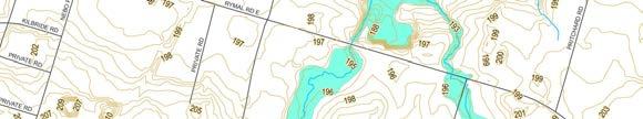
7 Study Area and Karst Field Monitoring Work Locations 7

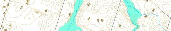
8 Stream Classification Note: Streams that were not assessed (no access granted) require further study Aquatic habitat was characterized based on review of previous data and field investigations. Stream habitats were classified as: Critical Habitat Important Habitat Marginal Habitat No Habitat 8
9 Stream Classification Fisheries Terrestrial Resources/Linkage Stream Morphology Flooding/Conveyance HIGH High quality habitat contains permanent, critical fish habitat and/or aquatic Species at Risk. Fish species observed. Contains designated significant natural heritage features (e.g. PSWs, Significant Woodlands, ESAs, SAR habitat). These corridors contain a defined channel with a well-developed channel morphology (i.e., rifflepool) and/or a well-defined valley. These corridors offer both form and function. Aids in flood control, wetland communities present MEDIUM Contributing habitat. Natural communities present, contributes to overall landscape connectivity. These reaches have a defined channel (bed and banks) or valley (e.g. gullies), may or may not have well-defined bed morphology (form) but do maintain geomorphic function and have potential for rehabilitation. In many cases, these reaches are presently exhibiting evidence of geomorphic instability or environmental degradation due to historic modifications and land use practices. Moderate flood control LOW Poor quality habitat does not directly support a fishery. No natural communities or wildlife habitat present. These reaches consist of ephemeral headwater systems that lack defined bed and banks (form) but do perform a geomorphic function through the conveyance of flow and sediment. Provides little flood control 9
10 Stream Classification Red Red streams are to be preserved as corridors; Red dashed streams are of similar importance as red streams, however significantly degraded. As such they require enhancement. When enhanced, relocation is feasible. Blue Blue streams are to be left as an open watercourse, but can be relocated. They should be reconstructed as a functioning riparian corridor system. Green Green Streams can become part of a piped system. 10


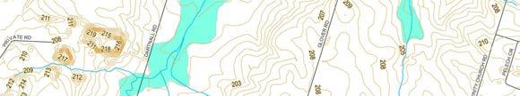
11 Updated Existing Conditions Floodline Mapping 11
12 Erosion Threshold Limit An Erosion Threshold Limit is the flow of stormwater that theoretically can cause erosion within the most sensitive part of a watercourse. In defined watercourses these flows are based on bed and bank materials and channel geometry. The Erosion Threshold Limit target is set so that proposed development conditions flows do not exceed the existing conditions target rate and cause erosion. Where the erosion threshold limit is exceeded at stream segment HC-3, upstream areas could be protected with increased LID targets, or this section of stream could be enhanced by carrying out stream restoration. 12
13 Water Balance A water balance describes the flow of water in and out of a system. An equation can be used to represent this equation, in this case represented by: Precipitation (P) = Evapotranspiration (E) + Recharge (Qc) + Runoff (Qs). A Water Balance was carried out to analyze the effects of the proposed development. Maintaining infiltration through the use of LID features will assist in maintaining the existing water balance. Existing Conditions vs Future Uncontrolled Conditions Water Balance Parameter Existing Conditions Future Conditions % Difference * Precipitation (P) 9,978,137 9,978,137 0% Evapotranspiration E 5,740,111 5,579,174-3% Recharge (Q c ) 1,877,607 1,555,731-17% Runoff (Q s ) 2,360,420 2,843,233 20% 13
14 Constraints Within the study there are several areas that have potential constraints to development Constraints are primarily related to natural environmental features (such as sensitive watercourses and Karst features) Constraints will be further reviewed by developers as part of proposed land use changes 14

 - Underground storage tanks (Private Initiative) - Parking Lot Storage (Private Initiative - Oil Grit Separators (Public Initiative)")
 Detention Facilities Involves")
15 Types of Alternatives 1) Do nothing Involves allowing development to occur in an uncontrolled manner. Results in flooding, erosion and also water quality degradation both within the future development lands and the lands downstream. 2) Source Control Measures This alternative puts the responsibility on the property owner to control run off in such a way that downstream flooding and erosion is avoided. Samples of this include: - Roof top storage (Private Initiative) - Underground storage tanks (Private Initiative) - Parking Lot Storage (Private Initiative - Oil Grit Separators (Public Initiative) Below provides a description of SWM alternatives. 3B) LID Source Control Measures Involves lot-level source controls that promote the infiltration. Samples of these include: Bioretention Downspout Disconnection Filter Strips Green Roofs Permeable Pavement Rainwater Harvesting Soakaway Pits Tree Planting 4) Detention Facilities Involves conventional stormwater facilities such as wet ponds, wetlands and dry ponds at the end of the flow conveyance system. 3) Low Impact Development (LID) 3A) LID Conveyance Control Measures Involve the linear stormwater transport systems that are often located within the road right-of-way such as ditches and sewers but they encourage infiltration. Samples include: - Bio-swales - Grassed Ditches - Perforated Pipes 5) Combination Low Impact Development Practices and Detention Facilities Combination 3) and 4) may also include 2) 15


16 LID Examples Residential Rainbarrel, Credit Conservation Enhanced Grass Swale Grey to Green Road Retrofits, Credit Valley Conservation Enhanced Grass Swale Prien & Newhof Bioretention Swale Grey to Green Road Retrofits, Credit Valley Conservation Etobicoke Exfiltration System, Ryerson University 16


17 Evaluation Criteria The screening level assessment is the first step in evaluating alternatives. The following screening level assessment criteria have been used to assess which alternatives will be carried forward to the full evaluation process. The screening criteria and evaluation are shown below: 17
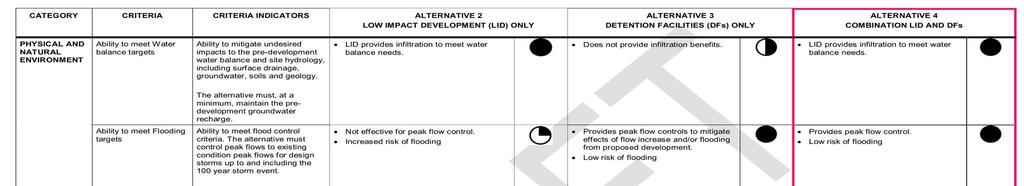
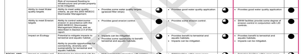
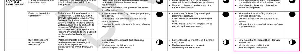
18 Detailed Evaluation of Stormwater Approach Alternatives 18


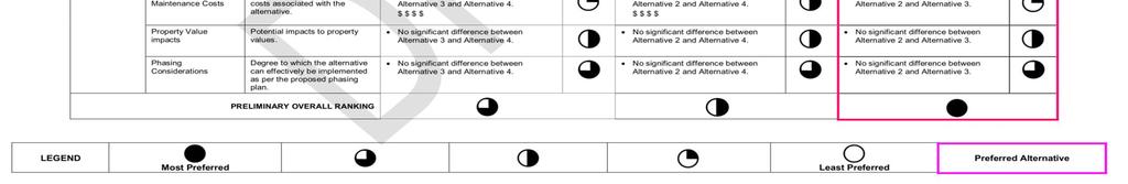
19 Detailed Evaluation of Stormwater Approach Alternatives Cont d 19

20 Preferred Alternative for Stormwater Management (SWM) Overall Strategy Based on the analysis, the preferred alternative is the combined LID control and detention storage option. This is the only option that satisfies all of the criteria and meets all of the targets. The LID controls are required to provide infiltration to meet the water balance targets, and to meet the erosion targets. The SWM facilities are required to mitigate peak flows so that the existing conditions flow targets are met. The SWM facilities also provide some degree of erosion control in conjunction with the LID controls. Lot Level Controls Individual development lot-level controls (opposed to Regional detention facilities) are the preferred method to mitigate future land use changes so that development can occur on a site by site basis. Conveyance or end-of-pipe controls would be difficult to fund and construct as the upstream sites would be developed at varying rates. Lot-level SWM facilities will provide water quality benefits and peak flow control. LID methods will provide infiltration to maintain the overall water balance, as well as to provide addition peak flow attenuation to meet the erosion threshold requirements. Although lot-level controls are recommended, the overall design is intended to mitigate the impacts of development on a watershed basis. Proposed lot level controls were conceptually designed so that the overall integrity of the watershed is maintained. Lot Level SWMF Example of Green Roof Surface Flow Path Diversion 20
21 Implementation Plan A conceptual Servicing Plan was developed to ensure that the existing flow regime is maintained, and that the required length of Low Constraint Streams (Previously shown in Green) are provided to maintain the drainage density requirement. All recommended projects fall under Schedule A (address through site plan) or Schedule A+ (work located in road allowance utility corridors). Schedule A and A+ projects are pre-approved (Schedule A+ projects include notice prior to construction). 21
22 Proposed Projects Addressed by this Study Facility ID Description Class EA Planning Schedule Considerations SWMFs 1-3 New Stormwater Management Facility (SWMF) Refer to Implementation Plan for general location Schedule A Individual land owners will assemble properties, complete land use concepts and functional servicing including siting SWMFs Approval addressed under the Planning Act (approval of consent, site plan, plan of subdivision or condominium) City will assume responsibility once constructed and in operation. NSS-1 Nebo Road Trunk Storm Sewer From Twenty Road East to approximately 400 metres south of Rymal Road East Approximately 900 metres in length Schedule A+ Requires public notice prior to construction Can be implemented as part of road improvements Assumes all works in existing ROW and trenchless water crossings (if required) TCSS-1 Trinity Church Road Trunk Storm Sewer Starts approximately 350 metres south of Rymal Road East Approximately 600 metres in length Schedule A+ Requires public notice prior to construction Can be implemented as part of road improvements Assumes all works in existing ROW and trenchless water crossings (if required) 22
23 Commitments City HCA Private Property Owner Developer Natural Environment Ensure all regulatory requirements to protect the environment are followed during construction to ensure minimal impact to the natural environment. Work with HCA to address potential impacts related to construction. Ensures developer s work is complete and follows this Master Plan and is sufficient to support development applications. Ensures developer s work is complete and sufficient to support development applications and follows this Master Plan. Floodplain Mapping An updated flood impact assessment of proposed developments may be required to confirm the initial findings within the Master Plan. Completion of flood impact assessments for tributaries that are to be maintained or relocated and that were not assessed through the Master Plan. Ensures developer s work is complete and is sufficient to support development applications. Ensures developer s work is complete and sufficient to support development applications and follows this Master Plan. Natural Heritage Completion of seasonally appropriate ecological inventories and assessments as part of an Environmental Impact Statement (EIS) may be required as part of development planning application(s) on a site-specific basis. Hydrogeology and Karst Completion of additional hydrogeological studies and assessments prior to development. 23


24 Next Steps Summer/ Autumn 2017 Review comments received Council endorsement File EA Addendum Report for 30-day public review period Future Select projects proceed to Preliminary and Detailed Design based on development proposals Future Select projects proceed to Tender and Construction Post construction monitoring of how Natural Heritage Features are responding 24

25 We appreciate the time you have taken to learn more about the project and we value your input. Stay involved and up-to-date as the project progresses: Join our mailing list: leave us your mailing address Visit the project website: /UpperHannonCreek Contact us with additional comments or questions at any time: Melanie Anderton Project Manager Growth Management City of Hamilton Phone: ext
WELCOME. Eastern Subwatersheds Stormwater Management Retrofit Study. Online Information Session #2 June 15 to July 13, 2018
 WELCOME Eastern Subwatersheds Stormwater Management Retrofit Study Online Information Session #2 June 15 to July 13, 2018 1 Eastern Subwatersheds Stormwater Management Retrofit Study This study is one
WELCOME. Eastern Subwatersheds Stormwater Management Retrofit Study. Online Information Session
 WELCOME Eastern Subwatersheds Stormwater Management Retrofit Study Online Information Session July 31 to Septemberember 19, 2014 1 Eastern Subwatersheds Stormwater Management Retrofit Study This study
Please complete the sign-in sheet and review display materials.
 Municipal Class Environmental Assessment Please complete the sign-in sheet and review display materials. As you move through the information presented today, we encourage you to ask questions and provide
MOECC Low Impact Development Stormwater Management Guidance Manual
 1 MOECC Low Impact Development Stormwater Management Guidance Manual Purpose The purpose of this presentation is to provide an update on work we are doing in preparation of a guidance document on low impact
Hydromodification Management Measures
 Chapter 7 Hydromodification Management Measures This Chapter summarizes the requirements for controlling erosive flows from development projects. 7.1 Why Require Hydromodification Management? Changes in
Hydromodification Management Measures
 Chapter 7 Hydromodification Management Measures This Chapter summarizes the requirements for controlling erosive flows from development projects. 7.1 Why Require Hydromodification Management? Changes in
Planning Considerations for Stormwater Management in Alberta. R. D. (Rick) Carnduff, M. Eng., P. Eng. February 20, 2013.
 Carnduff, M. Eng., P. Eng. February 20, 2013.") Planning Considerations for Stormwater Management in Alberta R. D. (Rick) Carnduff, M. Eng., P. Eng. February 20, 2013 Photo Optional Purpose The purpose of urban stormwater management is to provide solutions
Planning Considerations for Stormwater Management in Alberta R. D. (Rick) Carnduff, M. Eng., P. Eng. February 20, 2013 Photo Optional Purpose The purpose of urban stormwater management is to provide solutions
Section 1 - Introduction
 VERSION 1.0 Stormwater Solutions for Residential Sites Section 1 - Introduction Prepared for EcoWater Solutions A Department of Waitakere City Council 113 Central Park Drive Henderson WAITAKERE CITY November
low impact development demonstration project
 NORTH HUMBER EXTENSION NEIGHBOURHOOD - KLEINBURG TMIG TRIECA Conference 2012 March 27 and 28 The International Centre Mississauga 8800 Dufferin Street Suite 200 Vaughan ON CA L4K 0C5 905 738 5700 www.tmig.ca
Primer introduction to watershed management Plan Process highlight the major steps of plan development Project types look at some examples of common
 1 Primer introduction to watershed management Plan Process highlight the major steps of plan development Project types look at some examples of common projects Plan Organization how to read the plan Next
COMPREHENSIVE ENVIRONMENTAL IMPACT STUDY & MANAGEMENT PLAN South Albion Bolton Community Plan Employment Needs & North Hill Commercial Lands Study
 COMPREHENSIVE ENVIRONMENTAL IMPACT STUDY & MANAGEMENT PLAN South Albion Bolton Community Plan Employment Needs & North Hill Commercial Lands Study Part A Study Components Background Information Review
Environmental Assessment Derry Road and Argentia Road Intersection
 Environmental Assessment Derry Road and Argentia Road Intersection Project 11-4295 City of Mississauga, Region of Peel October 15, 2014 INTRODUCTION Table of Contents Introduction... 2 Description of the
Public Information Centre September 19 th, 2017
 Public Information Centre September 19 th, 2017 WELCOME! Public Information Centre for the Maple Hill Creek Rehabilitation Class Environmental Assessment Please take the time to sign our sign in sheet
Torbram Road Improvements From Queen Street East to Bovaird Drive
 Torbram Road Improvements From Queen Street East to Bovaird Drive Municipal Class EA Study Public Information Centre No. 1 November 16 2017 6:30 pm 8:30 pm Please sign in so we can keep you updated on
Public Information Centre No. 2
 Public Information Centre No. 2 Stoney Creek and Battlefield Creek Flood and Erosion Control Project East Escarpment Watershed Restoration Program Conservation Ontario Class Environmental Assessment Date:
Incorporating Restoration Planning and Transportation Controls into the Valley Creek Watershed Act 167 Stormwater Management Plan
 Incorporating Restoration Planning and Transportation Controls into the Valley Creek Watershed Act 167 Stormwater Management Plan Pennsylvania State Section American Water Resources Association Fall 2011
City of Mississauga Environmental Impact Studies Terms of Reference 2002
 City of Mississauga Environmental Impact Studies Terms of Reference 2002 1.0 INTRODUCTION To ensure in so far as possible, both private and public developments are consistent with Natural Heritage and
Town of Aurora Stream Management Master Plan PUBLIC INFORMATION CENTRE May 1 st, 2018
 Town of Aurora Stream Management Master Plan PUBLIC INFORMATION CENTRE May 1 st, 2018 Your comments are encouraged and appreciated, as this will provide us an opportunity to address project issues and
Section 3 General Development Policies
 3.4.6 Substandard System Improvements The Municipality will actively encourage the participation of its residents in any program that the HKPRDHU or the MOE designed to upgrade or replace existing substandard
CHAPTER 7: guidance. categories: Pollutant Removal. Jordan Lake watershed) Cisterns. Bioretention Areas. Green Roofs. Dry. Proprietary Devices
 Cisterns. Bioretention Areas. Green Roofs. Dry. Proprietary Devices") CHAPTER 7: TOOLBOXES A. Water Quality BMP Toolbox The Water Quality BMP Toolbox is intended for use by Town off Cary staff and citizens for guidance regarding implementation of traditional, non-traditional,
CHAPTER 7: TOOLBOXES A. Water Quality BMP Toolbox The Water Quality BMP Toolbox is intended for use by Town off Cary staff and citizens for guidance regarding implementation of traditional, non-traditional,
Clean Water Services Design and Construction Standards Update: Base Strategy and Methodology to Address Hydromodification Impacts
 Clean Water Services Design and Construction Standards Update: Base Strategy and Methodology to Address Hydromodification Impacts 1.0 INTRODUCTION The proposed hydromodification base strategy (Base Strategy)
Effectiveness of Non-Structural Measures in Watershed Restoration
 Effectiveness of Non-Structural Measures in Watershed Restoration Bill Frost, PE, D.WRE Sr. Water Resources Engineer KCI Technologies, Inc. Sparks, MD 2011 Low Impact Development Symposium Philadelphia,
I-3 THE IMPERVIOUS COVER MODEL
 I-3 THE IMPERVIOUS COVER MODEL AT A GLANCE Imperviousness is a metric that represents the sum of roads, parking lots, sidewalks, rooftops, and other impermeable surfaces that prevents water from infiltrating
The proponent is responsible for meeting all approval requirements from relevant agencies.
 5.0 INFILL DEVELOPMENT 5.1 General Infill projects can range in size from a single lot to the complete redevelopment of significantly larger areas. Many forms of infill development can be more intensive
Andrea Ludwig, PhD, EIT Assistant Professor Biosystems Engineering and Soil Science University of Tennessee
 Andrea Ludwig, PhD, EIT Assistant Professor Biosystems Engineering and Soil Science University of Tennessee 2 Circa 1891 3 Circa 1900 4 5 Urban Development Stormwater NPDES Permits Phase I (n=4); pop>100,000
Public Information Centre # 2 Flood Mitigation Opportunities Study Fourteen Mile Creek & M c Craney Creek Systems Town of Oakville
 Public Information Centre # 2 Flood Mitigation Opportunities Study Fourteen Mile Creek & M c Craney Creek Systems Town of Oakville Municipal Class Environmental Assessment Study Area The limits of the
Appendix A. Compliance Calculator Guidance
 Compliance Calculator Guidance Appendix A Appendix A. Compliance Calculator Guidance A.1 Introduction The Center for Watershed Protection created the compliance calculator spreadsheet to allow a designer
LID & Detention Pond Sizing Tool to Address Hydromodification and Water Quality in Clackamas County
 LID & Detention Pond Sizing Tool to Address Hydromodification and Water Quality in Clackamas County Leah Johanson, Water Environment Services February 12 th, 2015 Agenda» WES History/Stormwater Standards»
Appendix A Stormwater Site Plan Report Short Form
 Appendix A Stormwater Site Plan Report Short Form The Stormwater Site Plan Report Short Form may be used for projects that trigger only Minimum Requirements #1-#5. These projects typically fall within
Ten Steps to Implementing ROW LID
 connecting drops the Ten Steps to Implementing ROW LID a presentation to TRIECA 2016 Implementing LID on a Watershed Basis and Making a Difference: A 10 Step Process March 24, 2016 John Nemeth, CET Infrastructure
iswm TM Criteria Manual City Date here
 City Date here December 2009 i Overview of the iswm Program The iswm Program for Construction and Development is a cooperative initiative that assists municipalities and counties to achieve their goals
The Role of Pervious Paving in Meeting the Requirements of the Auckland Unitary Plan
 The Role of Pervious Paving in Meeting the Requirements of the Auckland Unitary Plan Nick Vigar Waterways Planning Team Manager Auckland Council Healthy Waters Outline Stormwater management under the Air,
CRWP NERRS Science Collaborative Site Selection Criteria & Scoring System CHAGRIN RIVER WATERSHED PARTNERS, INC.
 CHAGRIN RIVER WATERSHED PARTNERS, INC. NATIONAL ESTUARINE RESEARCH RESERVE SYSTEM SCIENCE COLLABORATIVE GRANT Implementing Credits and Incentives for Innovative Stormwater Management REQUEST FOR PROPOSALS
Natural Systems Planning Primer
 Natural Systems Planning Primer Lise.Guevremont@ottawa.ca Amy.Macpherson@ottawa.ca Land Use and Natural Systems Unit Planning and Growth Management November 2015 1 Welcome Policy Framework Development
SCRCA SECTION 28 WETLAND POLICY
 April 21, 2016 SCRCA SECTION 28 WETLAND POLICY SCRCA Policies and Procedures of Administration of Section 28 Regulations Wetland Policies Definitions section (Source: Section 28 CA Act) Development means:
HMP 101 Hydromodification Management Plan for Santa Clara Valley Guidance for Local Implementation
 HMP 101 Hydromodification Management Plan for Santa Clara Valley Guidance for Local Implementation Jill C. Bicknell, P.E., EOA, Inc. Assistant Program Manager EOA, Inc. GeoSyntec Consultants Presentation
Oshawa Creek Watershed Management Plan EXECUTIVE SUMMARY
 Oshawa Creek Watershed Management Plan EXECUTIVE SUMMARY The Central Lake Ontario Conservation Authority (CLOCA) has recognized the need to prepare comprehensive management strategies for all of its watersheds.
Post-Development Stormwater Runoff Performance Standards
 Post-Development Stormwater Runoff Performance Standards December 9, 2014 Topics Why performance standards? What practices/requirements are in effect in other States? The Workgroup s preliminary and final
3.3 Acceptable Downstream Conditions
 iswm TM Criteria Manual - = Not typically used or able to meet design criterion. 1 = The application and performance of proprietary commercial devices and systems must be provided by the manufacturer and
THE RED HILL VALLEY PROJECT STORMWATER MANAGEMENT DESIGN. Ronald B. Scheckenberger, M. Eng., P. Eng. Philips Engineering Ltd.
 THE RED HILL VALLEY PROJECT STORMWATER MANAGEMENT DESIGN Ronald B. Scheckenberger, M. Eng., P. Eng. Philips Engineering Ltd. Chris Murray Acting Director, Red Hill Valley Project City of Hamilton Paper
Ten Steps to Implementing ROW LID
 connecting drops the Ten Steps to Implementing ROW LID UTRCA Symposium Low Impact Development: Opportunities for Municipalities Implementing LID on a Watershed Basis and Making a Difference: A 10 Step
CVC Wetland Restoration Strategy
 CVC Wetland Restoration Strategy Overview Strategy Development Process Methodology & Analysis Modules Strategic Units & Results Strategy Integration in CVC Programs Strategy Development Wetland Restoration
CITY OF HAMILTON STORM DRAINAGE POLICY. May Philips Engineering Ltd North Service Road P. O. Box 220 Burlington, Ontario L7R 3Y2
 CITY OF HAMILTON STORM DRAINAGE POLICY May 2004 Philips Engineering Ltd. 3215 North Service Road P. O. Box 220 Burlington, Ontario L7R 3Y2 Telephone: (905) 335-2353 Facsimile: (905) 335-1414 E-Mail Address:
Flood Mitigation Opportunities Study Fourteen Mile Creek & McCraney Creek Systems
 Town of Oakville Flood Mitigation Opportunities Study Fourteen Mile Creek & McCraney Creek Systems November 14, 2013 Study Area The limits of the study area extend from Lake Ontario to Dundas Street. McCraney
Policy Review of Municipal Stormwater Management in the Light of Climate Change Summary Report
 Policy Review of Municipal Stormwater Management in the Light of Climate Change Summary Report Executive Summary In response to an Application for Review submitted under the Environmental Bill of Rights,
Type of Problem. All existing and anticipated future problems/concerns. Building Flooding Drainage Issue Street Flooding Restrictive Structure
 Jeffersonville Stormwater Master Plan (SWMP) Advisory Committee Meeting Worksheet (1/10/12) SUMMARY OF SUGGESTED TARGET STUDY AREAS & PROMISING SOLUTIONS FOR EVALUATION IN PHASE 2 Problem Area Name 1 Existing
APPENDIX G METHODOLOGY FOR EVALUATING RETROFIT OPTIONS/RETROFIT STUDIES
 APPENDIX G METHODOLOGY FOR EVALUATING RETROFIT OPTIONS/RETROFIT STUDIES G.1 Introduction Retrofitting of existing infrastructure may be required to achieve water balance, water quantity, water quality,
Stormwater BMP Maintenance
 Stormwater BMP Maintenance Background and Definitions What is Stormwater Runoff? Stormwater Stormwater is the result of precipitation that flows overland to streams and other bodies of water Stormwater
Chapter 7: Utilities and Stormwater Management
 Chapter 7: Utilities and Stormwater Management Utilities are essential services that affect future land use and growth areas, stormwater management, and energy use. Chapter 7 of this Comprehensive Plan
CATEGORY a protection of the natural environment, its ecosystems and biodiversity.
 29. ENVIRONMENTAL DEVELOPMENT PERMIT AREA CATEGORY a protection of the natural environment, its ecosystems and biodiversity. The requirement to obtain an environmental development permit is cited in Section
2017 Wet Weather Flow Master Plan Implementation Status Update
 PW21.6 REPORT FOR ACTION 2017 Wet Weather Flow Master Plan Implementation Status Update Date: April 24, 2017 To: Public Works and Infrastructure Committee From: General Manager, Toronto Water Wards: All
Pennsylvania Stormwater Best Management Practices Manual. Chapter 3. Stormwater Management Principles and Recommended Control Guidelines
 Pennsylvania Stormwater Best Management Practices Manual Chapter 3 Stormwater Management Principles and Recommended Control Guidelines 363-0300-002 / December 30, 2006 Chapter 3 Stormwater Management Principles
3. SHIRLEY S BROOK / WATTS CREEK SUBWATERSHED STUDY COMMITTEE RECOMMENDATION
 3. SHIRLEY S BROOK / WATTS CREEK SUBWATERSHED STUDY COMMITTEE RECOMMENDATION That Council endorse the Shirley s Brook/Watts Creek Subwatershed Study (September 1999) as the technical document to guide
Thinking about developing or building on land with ponding or drainage issues?
 Thinking about developing or building on land with ponding or drainage issues? Much of the Kāpiti Coast is low-lying and subject to flooding, ponding or drainage issues. We need to pay careful attention
Concurrent Session B: LID Design Specifications (Chapter 4 in Draft Manual)
") Concurrent Session B: LID Design Specifications (Chapter 4 in Draft Manual) Should vs. Must In Chapter 4, should means should, and must means must. Poorly Drained Soils Well-Drained Soils Flat Terrain
Concurrent Session B: LID Design Specifications (Chapter 4 in Draft Manual) Should vs. Must In Chapter 4, should means should, and must means must. Poorly Drained Soils Well-Drained Soils Flat Terrain
June 27, 2012 Holly Galavotti U.S. EPA
 June 27, 2012 Holly Galavotti U.S. EPA Urban stormwater is a leading source of water quality impairment Urban stormwater identified as source of impairment (2004 WQ Report) 22,559 miles of impaired rivers
n4.1 Site Assessment for Runoff Reduction Requirements
 Chapter 4 Smart Design for Stormwater Management 4.1 Site Assessment for Runoff Reduction Requirements 4.2 Site Water Balance 4.3 Runoff Reduction Volume 4.4 Runoff Treatment Volume 4.5 Flood Control and
CITY OF AUSTIN'S REGULATORY FRAMEWORK FOR CREEK PROTECTION
 CITY OF AUSTIN'S REGULATORY FRAMEWORK FOR CREEK PROTECTION Liz Johnston, Watershed Protection Department Urban Riparian Symposium February 15 17, 2017 Houston, TX Valuable Resource Drinking Water Intake
Municipal Stormwater Ordinances Summary Table
 APPENDIX F Municipal Ordinances Summary Table Municipality Abington Bryn Athyn Borough Hatboro Borough Ordinance, SALDO Runoff equals pre post Erosion Sediment Control Water Quality Requirements Any which
The Scope of Integrated Stormwater Management
 Stormwater Planning Guidebook The Scope of Integrated Stormwater Management Chapter Three 3.1 Overview and Context Connecting the Natural and Built Environments Integration Means Tackling Water Quantity
DUBUQUE COUNTY SMART PLAN Watershed Management
 Introduction Dubuque County Watersheds are in a state of constant change. Land use changes, Agricultural farming practices, and urban development has produced habitat alteration and a drastic increase
Drainage Criteria Manual Review
 City of Colorado Springs Stormwater Management Assessment and Standards Development Drainage Criteria Manual Review March 8, 2013 Springsgov.com/City Agencies/Stormwater/Stormwater Engineering/ Stormwater
Chapter 6. Hydrology. 6.0 Introduction. 6.1 Design Rainfall
 6.0 Introduction This chapter summarizes methodology for determining rainfall and runoff information for the design of stormwater management facilities in the City. The methodology is based on the procedures
Headwater Drainage Feature Assessment:
 Prepared for: Jim Dougan, MSc Principal & Senior Ecologist DOUGAN & ASSOCIATES Ecological Consulting & Design 77 Wyndham Street South, Guelph, ON, N1E 5R3, Headwater Drainage Feature Assessment: In Support
Our A Team APDS Contracting
 1 Our A Team APDS Contracting 2 Definition of the Problem 3 Canal Importation Basin 4 Existing Floodplain 5 Development by Decades 6 Contributing Factors to Flooding Historic streams obliterated by irrigation
Headwater Drainage Features
 Headwater Drainage Features Their Natural Functions and an Interim Guideline for their Evaluation, Classification and Management Susan Jorgenson (CVC) & Laura Del Giudice (TRCA) Urban development within
Nose Creek Watershed Partnership NOSE CREEK INTERNAL DRAINAGE AREAS STUDY FINAL REPORT MAY, 2013
 NOSE CREEK INTERNAL DRAINAGE AREAS STUDY FINAL REPORT MAY, 2013 NOSE CREEK WATERSHED PARTNERSHIP NOSE CREEK INTERNAL DRAINAGE AREAS STUDY Final Report (29123 001 00) May, 2013 Suite 260, East Atrium, 2635
Instructions for Notice of Ground Disturbance Form:
 Instructions for Notice of Ground Disturbance Form: Prior to beginning any ground disturbance activity or finalizing your storm water plan, submit a completed 2 page Notice of Ground Disturbance Form to
Progressive Solutions for a Historic Watershed
 Progressive Solutions for a Historic Watershed Presenters: Clifford A. Shrive, PE, BCEE Brad S. Clark, PE Adam C. Hoff, PE June 20, 2012 Progressive Solutions for a Historic Watershed Overview of Presentation
CLOCA Rural & Agricultural Guide to Permits
 CLOCA Rural & Agricultural Guide to Permits Regulation of Development, Interference with Wetlands and Alterations to Shoreline and Watercourses, Ontario Regulation 42/06 April 2014 Table of contents Introduction...
Impact of Increased Stormwater Runoff on Urban Drainage Systems
 Impact of Increased Stormwater William E. Spearman, III, PE APWA Stormwater Summit San Antonio, TX September 12, 2007 Contact Information: William E. Spearman, III, PE Member, APWA National Water Resources
The SuDS Manual Frequently asked questions
 The SuDS Manual Frequently asked questions 1. Is source control still a requirement of the new SuDS Manual? Yes. Source control components are fundamental elements of a SuDS scheme. The benefits of source
D Olive Watershed. Path Toward Restoration
 D Olive Watershed Path Toward Restoration Water is the most critical resource issues of our lifetime and our children s lifetime. The health of our waters is the principal measure of how we live on the
City of Hamilton April 2016 Mid-Spencer/Greensville Rural Settlement Area Subwatershed Study
 7 EVALUATION OF ALTERNATIVES 7.1 General This chapter will: provide a general description of the types of alternative solutions that were considered in order to address the key constraints as defined in
New Castle County, DE. Floodplain Regulations
 New Castle County, DE Floodplain Regulations John J. Gysling, PE CFM Department of Land Use New Castle County, DE February 26, 2009 Today s Presentation Floodplain Protection and Uses Terms and Definitions
OurFuture. Protecting. March Ontario Provincial Plans and Conservation Authorities
 Protecting OurFuture Ontario Provincial Plans and Conservation Authorities March 2015 Greenbelt Plan I Niagara Escarpment Plan I Growth Plan for the Greater Golden Horseshoe I Oak Ridges Moraine Conservation
Sustainable Water Resource Practices
 Sustainable Water Resource Practices This section is related to and shoudl be read in conjunction with the Land Use Element, and Conservation Element. Implementing sustainable water resource practices
EXECUTIVE SUMMARY - REVISED
 EXECUTIVE SUMMARY REVISED INTRODUCTION The purpose of the Town of Salem Storm Water Management Plan is to develop recommendations and implementation strategies for addressing drainage problems and minimizing
Virginia Stormwater Regulations Proposed Changes. Planning Commission May 5, 2009
 Virginia Stormwater Regulations Proposed Changes Planning Commission May 5, 2009 WHY MANAGE STORMWATER ANYWAY?? ISSUES OF: 1. Pollution runoff from surfaces 2. Increased volumes of water 3. Increased velocities
Krista Reininga, PE Hydromodification and What it Means for the Design of Stormwater Facilities
 Krista Reininga, PE Hydromodification and What it Means for the Design of Stormwater Facilities Agenda 1. Evolution of Water Quality Facilities 2. Regulatory Response/MS4 Permit Requirements 3. Change
Big Creek Watershed Retrofit Ranking Project
 Big Creek Watershed Retrofit Ranking Project John Stein and Jennifer Olson Tetra Tech, Inc. Bob Gardin, FOBC Innovative Stormwater Conveyance Through Green Infrastructure May 13, 2014 Presentation Outline
Stormwater Erosion Control & Post-Construction Plans (Stormwater Quality Plans)
") Stormwater Erosion Control & Post-Construction Plans (Stormwater Quality Plans) Allen County Stormwater Plan Submittal Checklist The following items must be provided when applying for an Allen County Stormwater
Stormwater Erosion Control & Post-Construction Plans (Stormwater Quality Plans) Allen County Stormwater Plan Submittal Checklist The following items must be provided when applying for an Allen County Stormwater
2014 Municipal Water Policy on Stormwater. Convention Policy Paper
 2014 Municipal Water on Stormwater Convention Paper Contents 1. Background... 3 Objective... 3 2. Statements... 4 Stormwater Management Guidelines for the Province of Alberta... 4 Municipal Government
Sunnyside Heights (Grandview Heights Area #2) Neighbourhood Concept Plan (NCP) - Engineering Servicing and Financial Strategies
 Neighbourhood Concept Plan (NCP) - Engineering Servicing and Financial Strategies") CORPORATE REPORT NO: R236 COUNCIL DATE: November 15, 2010 REGULAR COUNCIL TO: Mayor & Council DATE: November 10, 2010 FROM: General Manager, Engineering FILE: 6520-20 (GH#2) SUBJECT: Sunnyside Heights
CORPORATE REPORT NO: R236 COUNCIL DATE: November 15, 2010 REGULAR COUNCIL TO: Mayor & Council DATE: November 10, 2010 FROM: General Manager, Engineering FILE: 6520-20 (GH#2) SUBJECT: Sunnyside Heights
Storm Water Permitting Requirements for Construction Activities. John Mathews Storm Water Program Manager Division of Surface Water
 Storm Water Permitting Requirements for Construction Activities John Mathews Storm Water Program Manager Division of Surface Water Why Permit Storm Water? Impacts During Construction Not an issue until
WATER QUALITY WORKSHOP
 OAK HILL PARKWAY WATER QUALITY WORKSHOP August 25, 2015 6 8 PM Oak Hill United Methodist Church Fellowship Hall AGENDA I. Welcome Lynda Rife, Facilitator II. III. Green Mobility Challenge Melissa Hurst,
PUBLIC INFORMATION CENTRE Class Environmental Assessment For. Black Creek Flood Management
 PUBLIC INFORMATION CENTRE Class Environmental Assessment For Conservation Ontario Class Environmental Assessment for Remedial Flood and Erosion Control Projects (2002) The Class EA for Remedial Flood and
Welcome South London Wastewater Servicing Study. Municipal Class Environmental Assessment Master Plan Public Information Centre.
 Welcome South London Wastewater Servicing Study Municipal Class Environmental Assessment Master Plan Public Information Centre February 26, 2018 The purpose of this Public Information Centre (PIC) is to:
GRAND NIAGARA Proposed Secondary Plan
 GRAND NIAGARA Proposed Secondary Plan Public Open House #3 January 17. 2017 scope + process BUILT Grand Niagara Secondary Plan The Grand Niagara Secondary Plan will establish a framework for the future
DEVELOPMENT AND INTERFERENCE WITH WETLANDS AND WATERCOURSES REGULATION - POLICIES AND PROCEDURES MANUAL For Planning Act Applications
 DEVELOPMENT AND INTERFERENCE WITH WETLANDS AND WATERCOURSES REGULATION - POLICIES AND PROCEDURES MANUAL For Planning Act Applications REVISED JANUARY, 2017 (administrative edits) Executive Board Motions
14(h)EPA-06 City of Springfield 76 East High Street Springfield, Ohio Clark County Greening City Plaza
EPA-06 City of Springfield 76 East High Street Springfield, Ohio Clark County Greening City Plaza") 14(h)EPA-06 City of Springfield 76 East High Street Springfield, Ohio 45502 Clark County Greening City Plaza $100,000 in FY 2014 Section 319(h) Nonpoint Source grant funding is requested to install three
14(h)EPA-06 City of Springfield 76 East High Street Springfield, Ohio 45502 Clark County Greening City Plaza $100,000 in FY 2014 Section 319(h) Nonpoint Source grant funding is requested to install three
Stormwater Infrastructure Funding Study Public Education Session May 27, :00 9:00 pm City Hall, Multi-Purpose Room Level 100
 Stormwater Infrastructure Funding Study Public Education Session May 27, 2015 7:00 9:00 pm City Hall, Multi-Purpose Room Level 100 What is the Stormwater Infrastructure funding study? Purpose of the Stormwater
How Climate Change Impacts Urban Runoff and Water Quality Design
 How Climate Change Impacts Urban Runoff and Water Quality Design by J. C. Hayes, C. Privette, III and S. J. Klaine AWRA Conference Anchorage, AK May 4-7, 2009 Presentation Outline Introduction: Why manage
ANCR INDIVIDUAL RESPONSES SUMMARY: 2/11/04 WATER RESOURCES GOALS AND OBJECTIVES
 ANCR INDIVIDUAL RESPONSES SUMMARY: 2/11/04 WATER RESOURCES GOALS AND OBJECTIVES Goal 1: Protect the health and safety of the Dane County population. a. Prevent development that may have an adverse effect
Watershed Improvements
 Watershed Improvements Gwinnett County Georgia Association of Floodplain Managers March 14, 2013 Overview Watershed Assessment - 1998 to 2000 Watershed Protection Plan - 2000 Watershed Improvement Plans
Chapter 3 Dispersion BMPs
 Chapter 3 Dispersion BMPs 3.1 BMP L611 Concentrated Flow Dispersion 3.1.1 Purpose and Definition Dispersion of concentrated flows from driveways or other pavement through a vegetated pervious area attenuates
Stormwater Management Update Requirements for Plans and Approvals. Doug Beisch (WEG, now Stantec)
") Stormwater Management Update Requirements for Plans and Approvals Doug Beisch (WEG, now Stantec) April 2, 2014 Introduction and overview Why are we here? About Stantec Williamsburg Environmental Group
Stormwater Management Update Requirements for Plans and Approvals Doug Beisch (WEG, now Stantec) April 2, 2014 Introduction and overview Why are we here? About Stantec Williamsburg Environmental Group
3 rd Annual TRIECA Conference March 25 & 26, CIVICA. Media Partner
 3 rd Annual TRIECA Conference March 25 & 26, 2014 www.trieca.com Thank you to all of our TRIECA 2014 Sponsors! CIVICA Media Partner City of Toronto Wet Weather Flow Management Guidelines 2014 Update TRIECA
Watershed master planning, City of Griffin, Georgia, USA
 Water Resources Management VII 3 Watershed master planning, City of Griffin, Georgia, USA J. K. Kaplan & B. J. Watson Tetra Tech, Water Resources Group, Atlanta, Georgia, USA Abstract Tetra Tech has assisted